An Ecological Flood Control System in Phoenix Island of Huzhou, China: A Case Study

Abstract
:1. Introduction
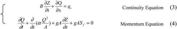
2. Methods
3. Analysis of Demands of Ecological Flood Control
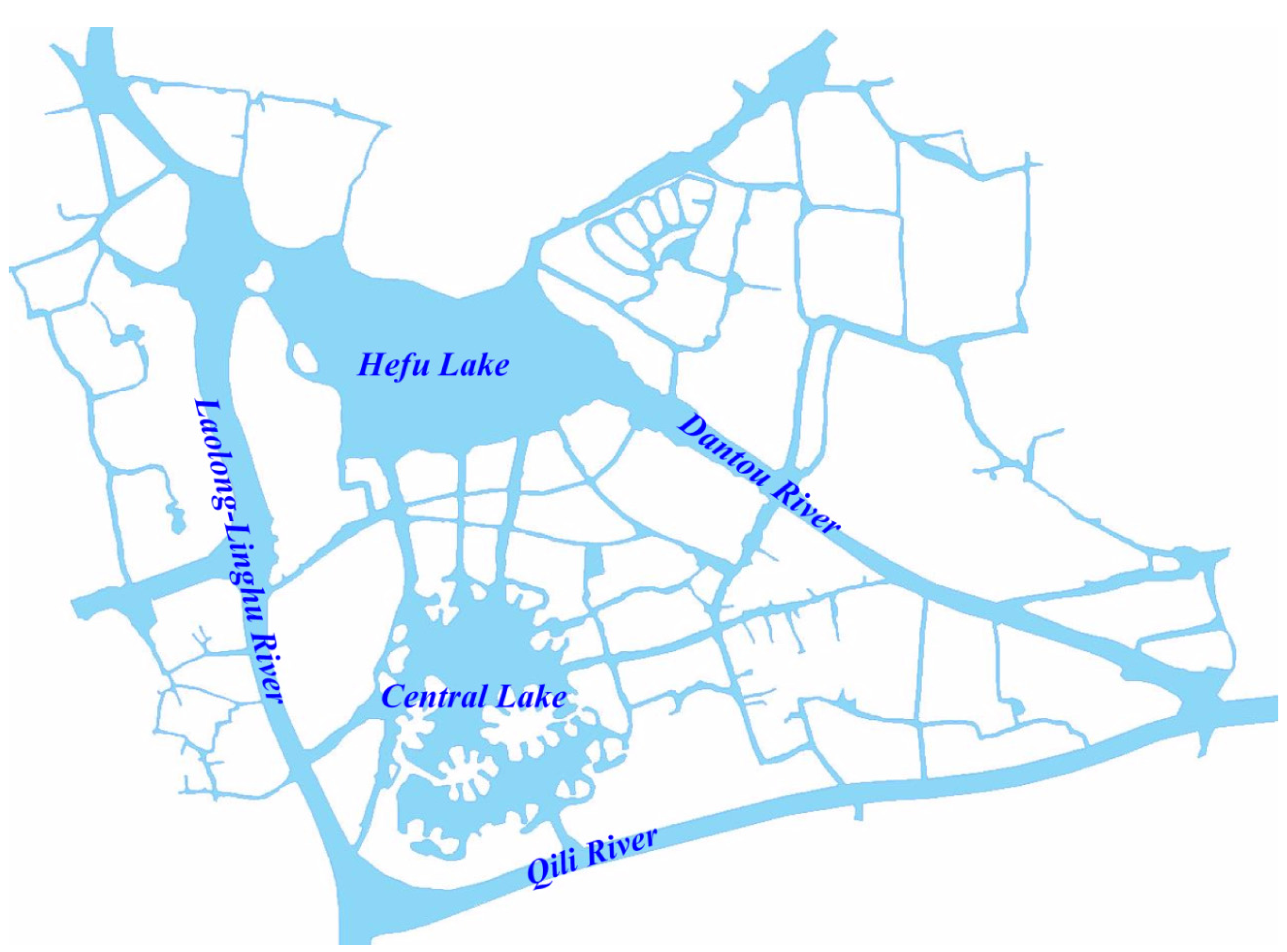
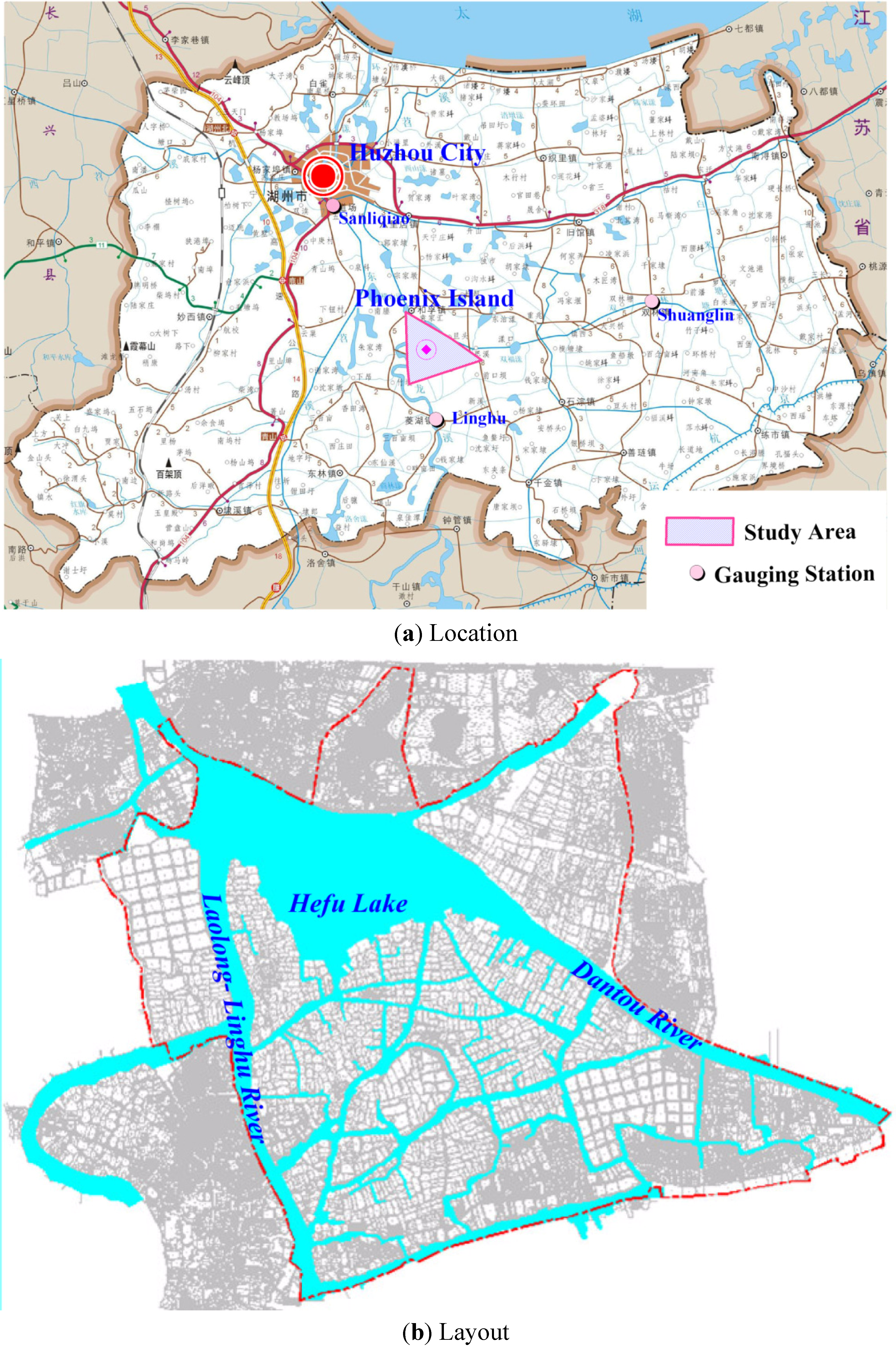
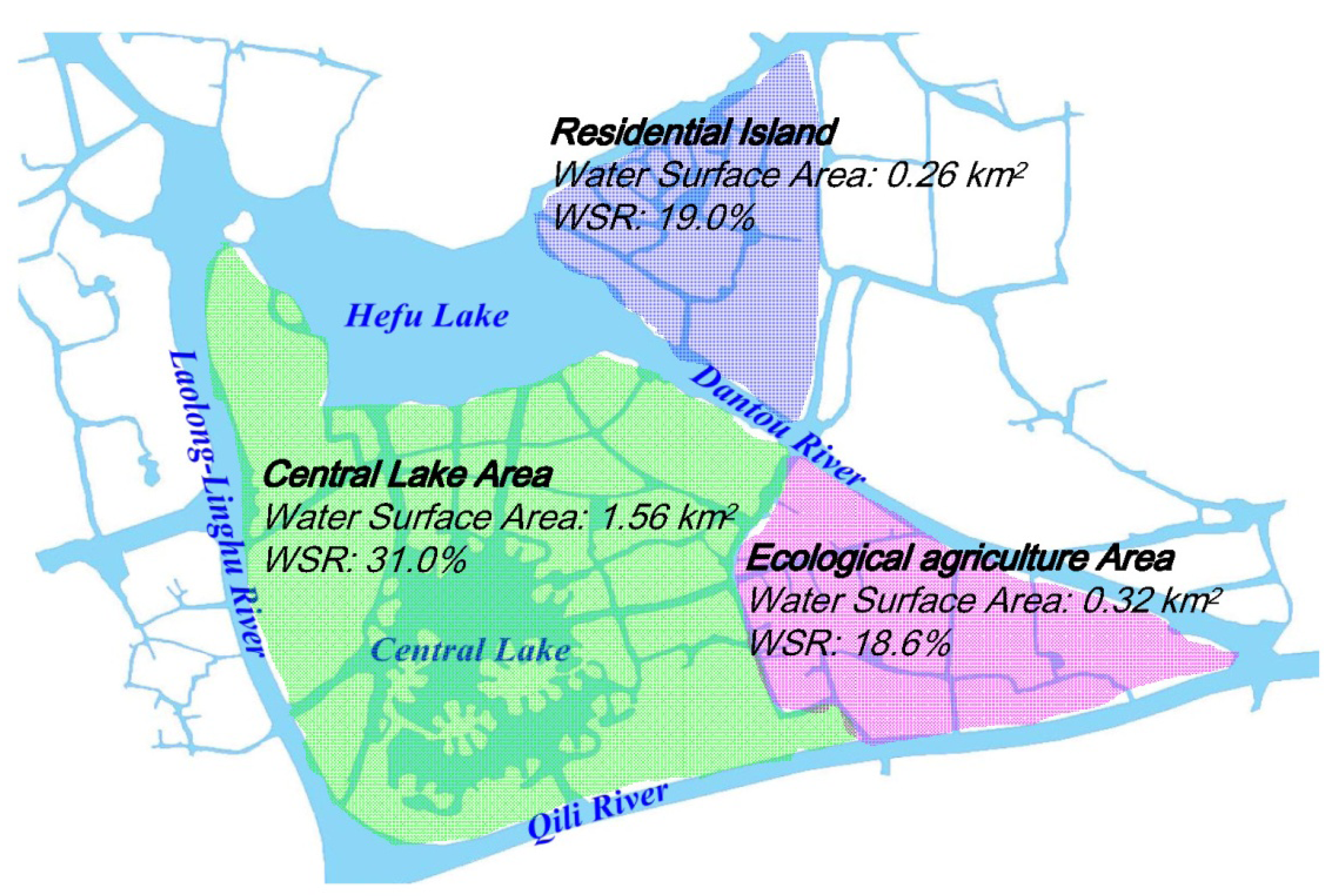
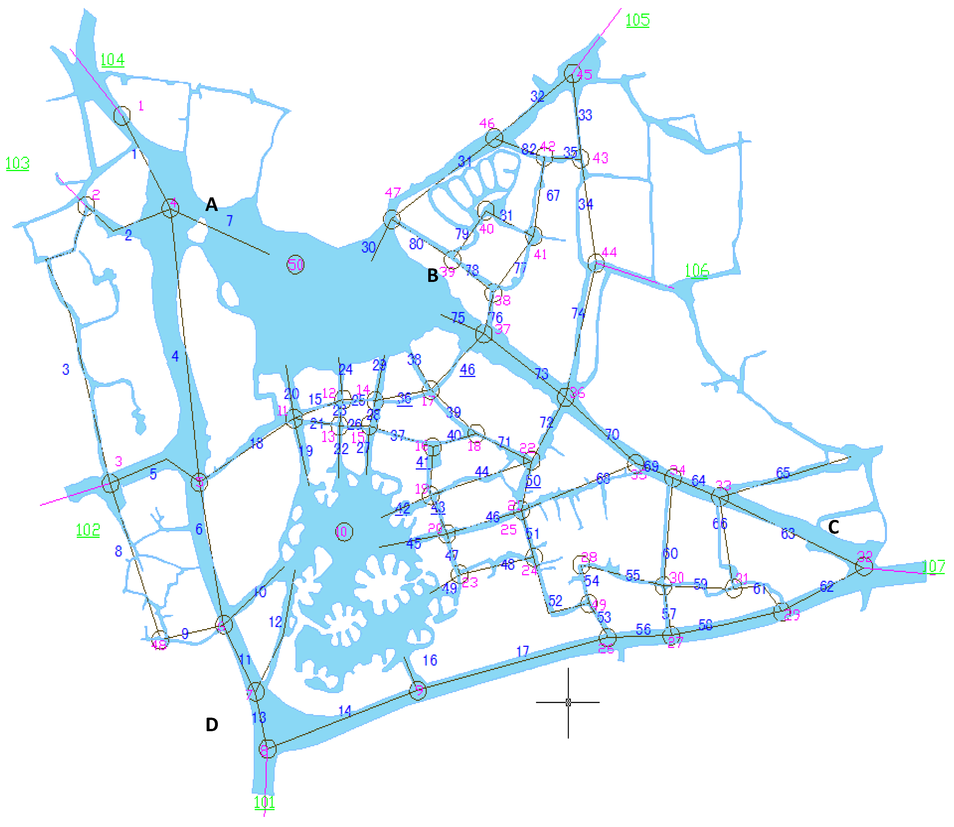
3.1. Overview of Phoenix Island
3.2. Demand for Connectivity of Water System

3.3. Demand for Landscapes of Water Bodies
3.4. Demand for Mobility of Water Bodies
3.5. Demand for Safety of Flood Control
4. Construction of Ecological Flood Control System
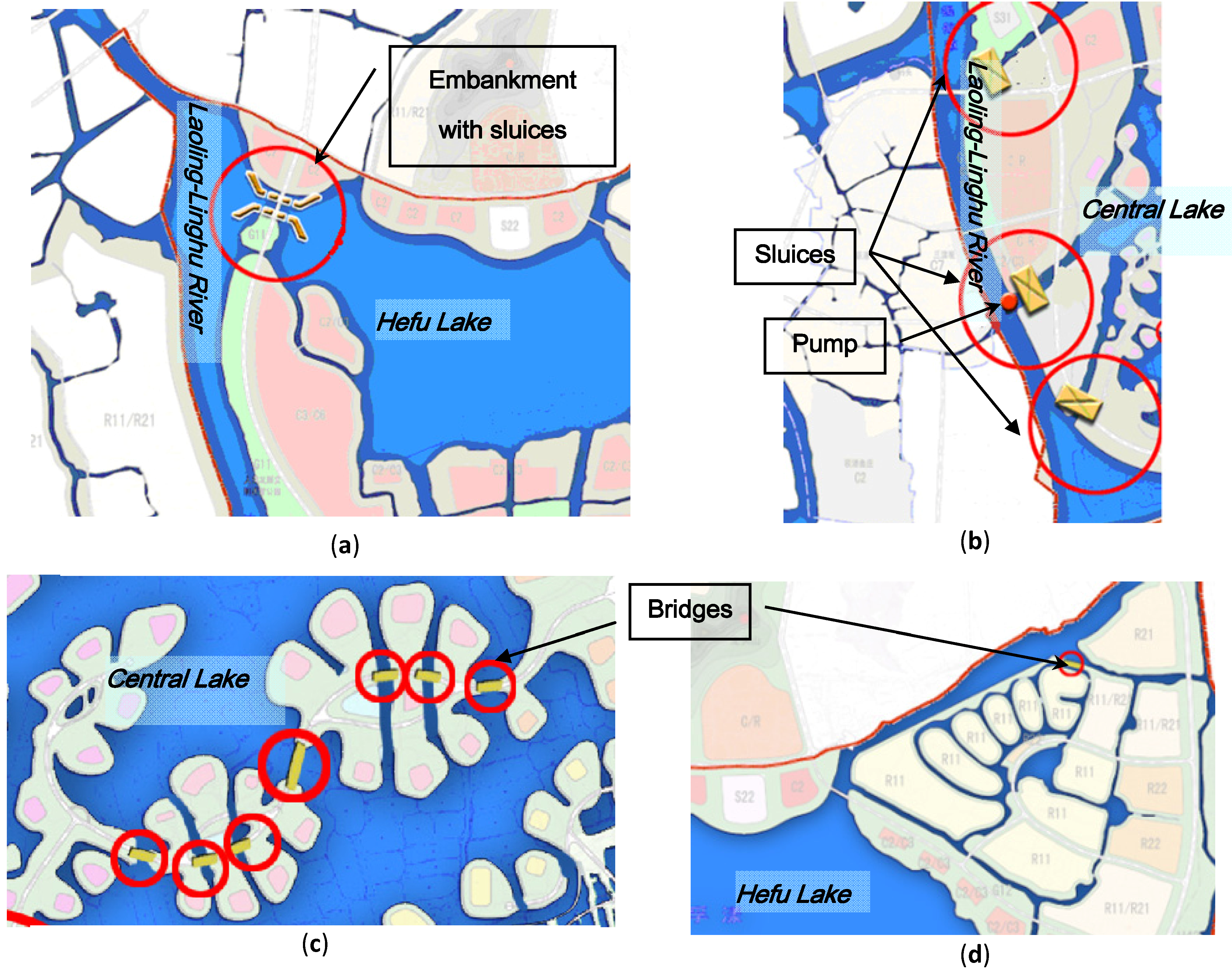
4.1. Adjustment of Water System Layout

4.2. Determination of the Controlled Water Levels for Landscapes

| Guarantee Rate | Water level (m) |
|---|---|
| 25% | 3.31 |
| 50% | 3.05 |
| 75% | 2.83 |
| 95% | 2.59 |
4.3. Analysis of Water System Mobility
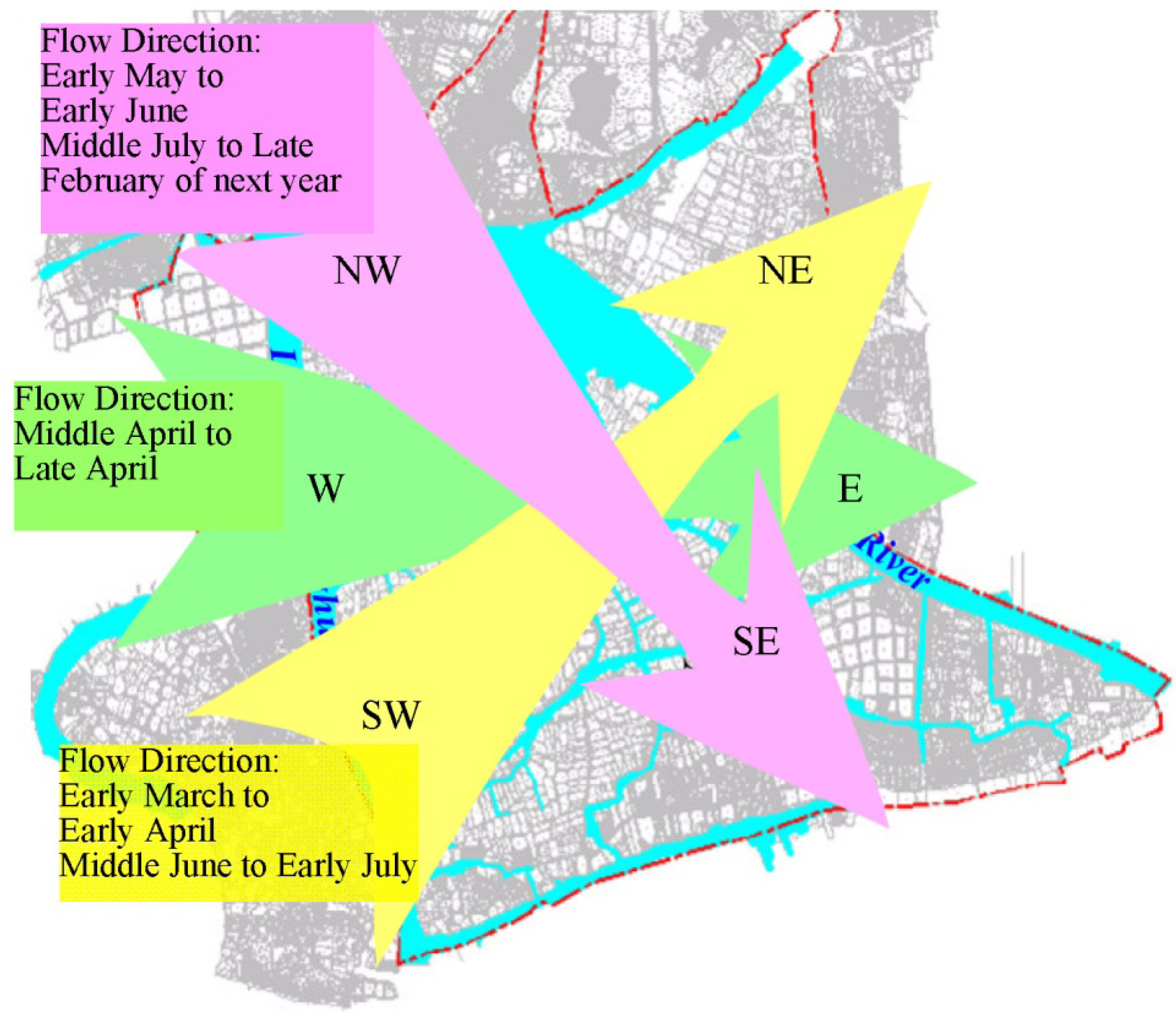
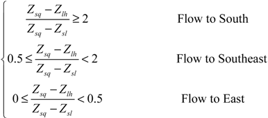
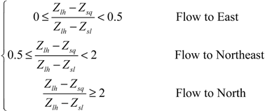
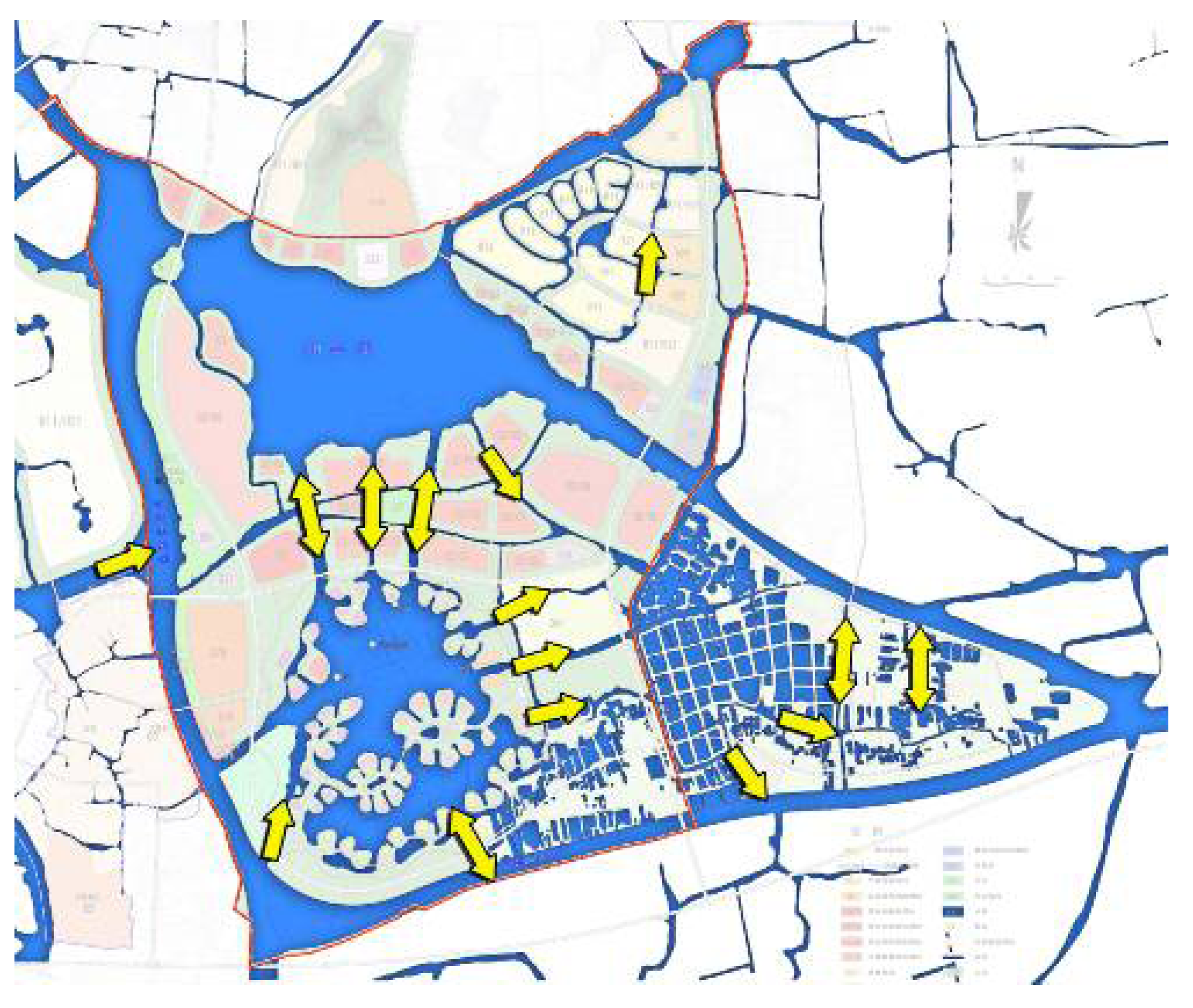
4.3.1. Flow Directions

4.3.2. Determination of Residence Time
| Typical Year | 25%(1998) | 50%(1997) | 75%(2007) | 95%(2003) |
|---|---|---|---|---|
| Rainfall (mm) | 1384.9 | 1226.9 | 1109.4 | 947.6 |
| Water Volume through the Area (million m3) | 552.33 | 453.94 | 595.21 | 628.55 |
| Local Runoff Volume (million m3) | 4.85 | 4.36 | 4.11 | 2.36 |
| Local Storage Volume (million m3) | 16.00 | 16.00 | 16.00 | 16.00 |
| Residence Time (day) | 10.5 | 12.8 | 9.7 | 9.3 |
| Frequency of Water Level | 25% | 50% | 75% | 95% |
|---|---|---|---|---|
| Corresponding water level (m) | 3.22 | 3.09 | 2.97 | 2.80 |
| Typical Year | 1975 | 1990 | 2004 | 1972 |
| Water level of Typical Year (m) | 3.23 | 3.11 | 2.96 | 2.82 |
| Rainfall of Typical Year (mm) | 1393.5 | 1240.3 | 1091.5 | 1052.9 |
| Frequency of Rainfall in Typical Year | 26% | 50% | 76% | 83% |
| Water Volume through the Area (million m3) | 831.75 | 560.75 | 537.82 | 536.06 |
| Local Runoff Volume(million m3) | 4.30 | 2.97 | 2.65 | 2.23 |
| Local Storage Volume (million m3) | 16.00 | 16.00 | 16.00 | 16.00 |
| Residence time (day) | 7.0 | 10.4 | 10.8 | 10.9 |
4.4. Verification of Flood Control
| Recurrence Period (year) | A | B | C | D |
|---|---|---|---|---|
| 100 | 5.33 | 5.32 | 5.32 | 5.35 |
| 50 | 5.16 | 5.14 | 5.14 | 5.17 |
| 20 | 4.90 | 4.89 | 4.89 | 4.91 |
| 10 | 4.68 | 4.67 | 4.67 | 4.70 |
| 5 | 4.43 | 4.42 | 4.42 | 4.44 |

4.5. Other Projects in Ecological Flood Control System
5. Conclusions
Acknowledgments
Conflicts of Interest
References
- Xu, W.L.; Zhang, J.; Zhao, Y.; Dai, B.; Deng, R. Analysis of coordinated development between eco-environment and socio-economy in Chengdu city. J. Catastrophol. 2007, 22, 129–133. [Google Scholar]
- Fu, Q.; Gao, J.; Chen, L. Ecological environment problems of Chongqing and corresponding countermeasures. J. Cent. South Univ. Technol. 2007, 14, 30–34. [Google Scholar] [CrossRef]
- Guo, J.C.Y.; Cheng, J.Y.C. Retrofit storm water retention volume for low impact development. J. Irrig. Drain. Eng. ASCE 2008, 134, 872–876. [Google Scholar] [CrossRef]
- Jia, H.; Ma, H.; Wei, M. Calculation of the minimum ecological water requirement of an urban river system and its deployment: A case study in Beijing central region. Ecol. Model. 2011, 222, 3271–3276. [Google Scholar] [CrossRef]
- Byeon, C.W. Ecological restoration of rivers and wetlands with a sustainable structured wetland biotope (SSB) system. KSCE J. Civ. Eng. 2012, 16, 255–263. [Google Scholar] [CrossRef]
- Song, X.Q.; Frostell, B. The DPSIR framework and a pressure-oriented water quality monitoring approach to ecological river restoration. Water 2012, 4, 670–682. [Google Scholar] [CrossRef]
- Yu, D.Y.; Xun, B.; Shi, P.J.; Shao, H.B.; Liu, Y.P. Ecological restoration planning based on connectivity in an urban area. Ecol. Eng. 2012, 46, 24–33. [Google Scholar] [CrossRef]
- Florens, F.B.V.; Baider, C. Ecological restoration in a developing island nation: How useful is the science? Restor. Ecol. 2013, 21, 1–5. [Google Scholar] [CrossRef]
- Pander, J.; Geist, J. Ecological indicators for stream restoration success. Ecol. Indic. 2013, 30, 106–118. [Google Scholar] [CrossRef]
- Mykra, H.; Tuomas, S.; Mikko, T.; Ben, M.; Heikki, H.; Kati, M.; Bjorn, K. Spatial and temporal variability of diatom and macroinvertebrate communities: How representative are ecological classifications within a river system? Ecol. Indic. 2012, 18, 208–216. [Google Scholar] [CrossRef]
- Ocampo-Duque, W.; Juraske, R.; Kumar, V.; Nadal, M.; Domingo, J.L.; Schuhmacher, M. A concurrent neuro-fuzzy inference system for screening the ecological risk in rivers. Environ. Sci. Pollut. Res. 2012, 19, 983–999. [Google Scholar] [CrossRef]
- Li, M.; Li, B. Calculation and analysis on ecological footprint of 2005 in Chongqing, China. J. Cent. South Univ. Technol. 2007, 14, 20–25. [Google Scholar]
- Wang, Q.; Wang, X.; Mao, Y.; Hu, X. Ecological footprint calculation and development capacity analysis in Wenzhou. J. Cent. South Univ. Technol. 2006, 13, 167–170. [Google Scholar]
- Li, H.; Cai, Y. Ecological risk assessment of flood disaster in major cities in Taihu basin. J. Catastrophol. 2002, 17, 91–95. [Google Scholar]
- Gao, C.; Liu, J.; Liu, X.Y.; Zhang, H.Y. Compensation mechanism of water surface ratio and pervious surface proportion for flood mitigation in urban areas. Disaster Adv. 2012, 5, 1294–1297. [Google Scholar]
- Chang, N.B. Low-impact development, sustainability science, and hydrological cycle. J. Hydrol. Eng. 2010, 15, 383. [Google Scholar] [CrossRef]
- Clary, J.; Quigley, M.; Poresky, A.; Earles, A.; Strecker, E.; Leisenring, M.; Jones, J. Integration of low-impact development into the international stormwater BMP database. J. Irrig. Drain. Eng. ASCE 2011, 137, 190–198. [Google Scholar] [CrossRef]
- Davis, A.P.; Hunt, W.F.; Traver, R.G.; Clar, M. Bioretention technology: overview of current practice and future needs. J. Environ. Eng. ASCE 2009, 135, 109–117. [Google Scholar] [CrossRef]
- Pyke, C.; Warren, M.P.; Johnson, T.; LaGro, J.; Scharfenberg, J.; Groth, P.; Freed, R.; Schroeer, W.; Main, E. Assessment of low impact development for managing stormwater with changing precipitation due to climate change. Landsc. Urban Plan. 2011, 103, 166–173. [Google Scholar] [CrossRef]
- Hurley, S.E.; Forman, R.T. Stormwater ponds and biofilters for large urban sites: Modeled arrangements that achieve the phosphorus reduction target for Boston’s Charles River, USA. Ecol. Eng. 2011, 37, 850–863. [Google Scholar] [CrossRef]
- Sun, D.Y.; Zhang, D.W.; Cheng, X.T. Framework of national non-structural measures for flash Flood disaster prevention in China. Water 2012, 4, 272–282. [Google Scholar] [CrossRef]
- Tsihrintzis, V.A.; Vasarhelyi, G.M.; Lipa, J. Multiobjective approaches in freshwater wetland restoration and design. Water Int. 1995, 20, 98–105. [Google Scholar] [CrossRef]
- Tsihrintzis, V.A.; Vasarhelyi, G.M.; Lipa, J. Hydrodynamic and constituent transport modeling of coastal wetlands. J. Mar. Environ. Eng. 1995, 1, 295–314. [Google Scholar]
- Tsihrintzis, V.A.; Vasarhelyi, G.M.; Lipa, J. Ballona Wetland: A multi-objective salt marsh restoration plan. Proc. Inst. Civ. Eng. Water Marit. Energy 1996, 118, 131–144. [Google Scholar] [CrossRef]
- Bueno, J.A.; Tsihrintzis, V.A.; Alvarez, L. South florida greenways: A conceptual framework for the ecological reconnectivity of the region. Landsc. Urban Plan. 1995, 33, 247–266. [Google Scholar] [CrossRef]
- Tsihrintzis, V.A.; John, D.L.; Tremblay, P.J. Hydrodynamic modeling of wetlands for flood detention. Water Resour. Manag. 1998, 12, 251–269. [Google Scholar] [CrossRef]
- Zhong, G.F. The mulberry dike-fish pond complex: A Chinese ecosystem of land-water interaction on the Pearl River Delta. Hum. Ecol. 1982, 10, 191–202. [Google Scholar] [CrossRef]
- Gao, C.; Liu, J.; Cui, H.; Hu, J. Treatment of pump drainage boundary in riverside city. Environ. Earth Sci. 2013, 68, 1435–1442. [Google Scholar] [CrossRef]
© 2013 by the authors; licensee MDPI, Basel, Switzerland. This article is an open access article distributed under the terms and conditions of the Creative Commons Attribution license (http://creativecommons.org/licenses/by/3.0/).
Share and Cite
Gao, C.; Liu, J.; Wang, Z. An Ecological Flood Control System in Phoenix Island of Huzhou, China: A Case Study. Water 2013, 5, 1457-1471. https://doi.org/10.3390/w5041457
Gao C, Liu J, Wang Z. An Ecological Flood Control System in Phoenix Island of Huzhou, China: A Case Study. Water. 2013; 5(4):1457-1471. https://doi.org/10.3390/w5041457
Chicago/Turabian StyleGao, Cheng, Jun Liu, and Zhuowen Wang. 2013. "An Ecological Flood Control System in Phoenix Island of Huzhou, China: A Case Study" Water 5, no. 4: 1457-1471. https://doi.org/10.3390/w5041457