1. Introduction
Declines in land quality caused by inappropriate land use and management practices are concerned to be an environmental and economic point [
1,
2,
3]. The cultivated land system is a synthesis of natural and socioeconomic factors [
4]. The interactions among these factors have an effect on land quality. Natural factors are usually intrinsic, substantial and relatively stable, whereas socioeconomic factors are extrinsic, invisible and dynamic [
1]. Spatial variability in landscapes arises from a combination of intrinsic and extrinsic factors, while temporal variability is mainly up to changes in soil characteristics and rainfall patterns overtime [
5]. Intrinsic spatial variability refers to natural variations in soil characteristics. These variations are related to soil formation processes, such as weathering, erosion and deposition [
6]. Meanwhile, extrinsic spatial variability refers to variations caused by a lack of uniformity in management practices, e.g., tillage, chemical application and irrigation [
6,
7]. Exploitation of natural resources, including land, leads to degradation and is also stimulated by socioeconomic and political issues. Examples of such issues include land tenure and lack of capital [
8,
9].
To date, considerable research has been conducted on the intrinsic spatial variability of soil properties that is closely related to soil quality. Scientific interest in the spatial variability in field soils dates back to the early 1890s [
10,
11], and the study on soil variability in a systematic way was carried out through the 1960s and 1970s [
12,
13]. Over the years, various indicators have been identified in the literature. E.g. regarding to field-scale soil water properties, the study of Nielsen et al. [
14] firstly demonstrated large variations in hydraulic conductivity values and infiltration rates from location to location. Five factors, identified by Xu et al. [
15], are critical in determining soil quality, specifically texture, organic matter, porosity, phosphorus and microstructure. Other researches, such as those that apply landscape function analysis (LFA), base their assessments on surface hydrological properties, i.e., infiltration, erosion, rainfall, runoff, plant growth and nutrient cycling [
16].
Land evaluation, which attempts to predict the behavior of land for particular uses, is different from soil quality assessment, because the soil biological parameters are not considered in land evaluation [
17]. The realistic assessment of CLQ depends on identification of the variables, which is crucial to the sustainable use of regional land resources [
1]. With the rapid development in rural society, socioeconomic factors are playing an important role in the land resource system and are more important than that of the natural setting sometimes [
1]. Following the FAO framework for land evaluation and the subsequent literature, socioeconomic factors have been more emphasized in land-quality evaluations [
18]. For example, changes in extrinsic spatial variability of selected macronutrients (Ca, Mg, K, and P) in surface (sandy) soils that resulted from tillage and fertilizer application were examined by Nkedi-Kizza et al. [
19]. Dumanski [
20] identified five sets of short-term indicators (nutrient balance, land use intensity, yield trends and variability, land use diversity and land cover) and three sets of long-term indicators (soil quality, agrobiodiversity and land degradation), as well as forest land quality, water quality, land contamination/pollution and range land quality. Thus, considerable research that characterizes intrinsic spatial variability has been performed, whereas fewer studies were carried on the spatial variability of cultivated land caused by extrinsic factors [
6]. To improve the understanding on spatial variability in field soils, more studies on addressing extrinsic and intrinsic variations were proposed by Rao and Wagenet [
5]. Currently, such studies are still lacking.
The equilibrium of land quality is easily disturbed by human activities, such as land consolidation and the behavior of farmers [
21]. The effects of these activities are especially noticeable in China in recent years; the overall CLQ has tended to decline and urban areas and the economy have seen rapid development. Because land consolidation is an extremely efficient method of preventing land parcels from being broken up and ameliorating existing difficulties, the consolidative cultivated land (CCL) can be defined as cultivated land being rearranged and taken precautionary measures to ensure more fruitful working of land areas on the basis of developing agricultural technology [
22,
23]. Scholars and industry have carried out a large number of relevant studies in the past thirty years on the changes in the quality of consolidated cultivated land (CCL) and the factors that drive such changes. For instance, Cay [
24] applied the analytic hierarchy process (AHP) to the reallocation process of land consolidation and evaluated the reallocation criteria and results. Caroline et al. [
25] quantified and modeled the effect of land consolidation and field borders about soil redistribution in agricultural landscapes. Coelho et al. [
26] presented a model that incorporates methods for the evaluation of performing agricultural systems before and after the transformations proposed in land consolidation projects. Tong Luyi [
27] explored a method for the evaluation of cultivated land based on a current grading dataset for achieving a national balance between the requisition and compensation of cultivated land and identifying the impacts of land consolidation.
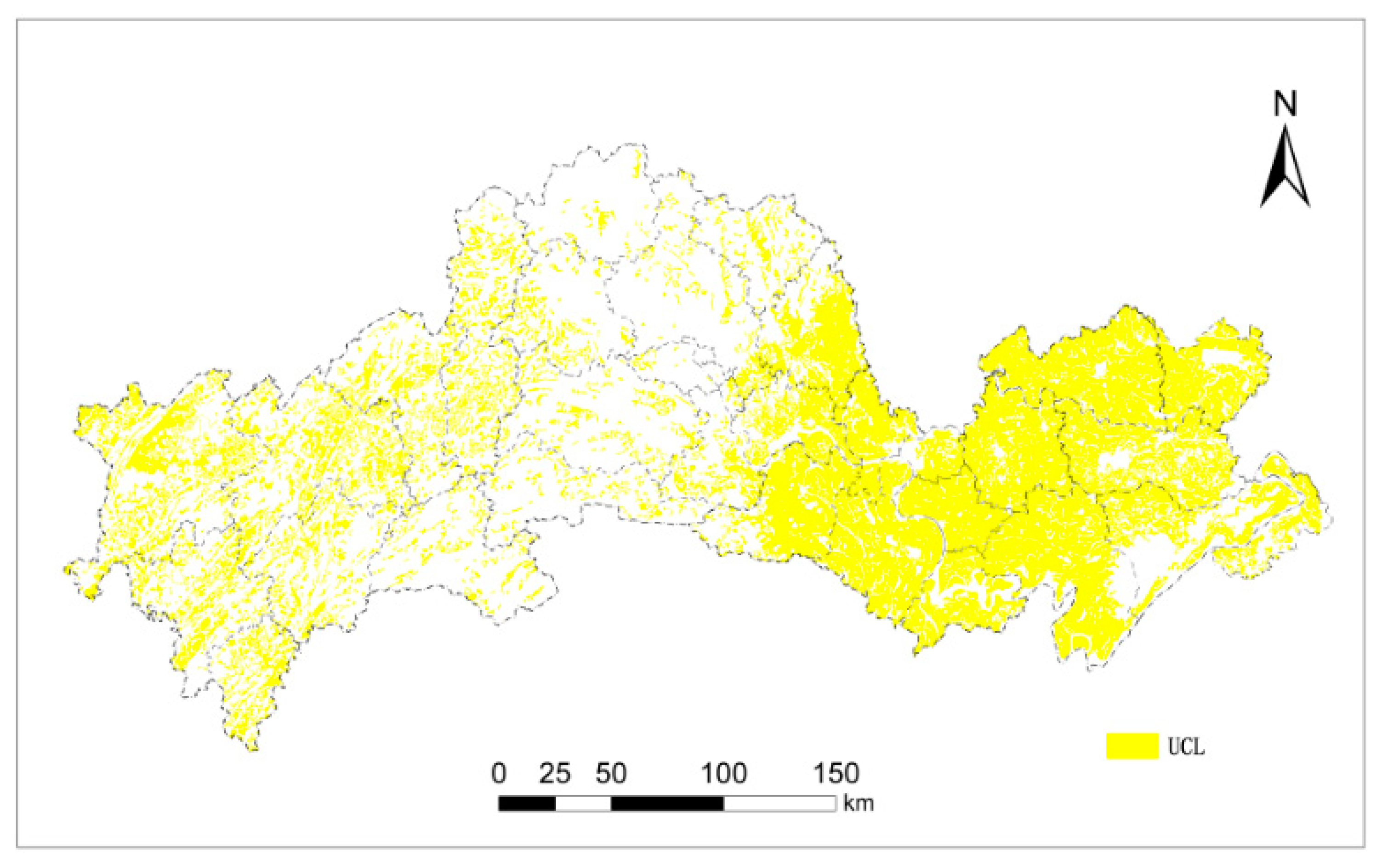
In China, a thematic strategy for the production of cultivated land called “Investigation and Evaluation of Cultivated Land Quality” is currently under development. First, the evaluation area is divided into two parts, depending on whether or not they were to experience land consolidation. In 2014, the 34 national provinces officially launched the evaluation of unconsolidated cultivated land (UCL) at the County level. In 2015, China carried out a comprehensive promotion of the implementation at the provincial level. The most important difference between UCL and CCL is that land consolidation is the main factor that causes the extrinsic spatial variability leading to changes in the CLQ of CCL, but not UCL. Within UCL, the natural factors are intrinsic and relatively stable, whereas the management practices of farmers, economic policies, and other factors maybe the key external driving forces in areas that have not experienced project investment and land consolidation. To date, we do not have a clear understanding of the changes in socioeconomic factors, although they sometimes play a more important role than natural factors.
Determining the internal and external factors that affect UCL, particularly the external factors, will help us to improve the land use conditions of CLQ more effectively. Moreover, it is also beneficial to combine UCL with land consolidation projects effectively. How to carry out a systematic evaluation of UCL that considers intrinsic and extrinsic factors has not been extensively studied, and empirical research is lacking.
Present work on the monitoring and evaluation of UCL still uses the evaluation system of GALQ that has been used in China since the early 2000s. However, the precision and real-time performance of this system, which is called “Global coverage,” cannot fulfill the requirements of the increasing degree of land resource management because monitoring actual changes in land use conditions is difficult [
27]. In addition, the pressure-state-response framework proposed by Dumanski and Pieri [
28], which is based on the behavior of farmers, is difficult to employ to perform a regionally comparable assessment of CLQ. Consequently, it is urgent to establish a reliable and applicable evaluation system for assessing the quality of UCL.
Therefore, establishing criteria to determine [
17] the quality of UCL and to develop indices is increasingly demanded. It may be used to rank and compare the quality of UCL at different locations or at the same location through time [
28,
29]. Moreover, it’s desirable to evaluate the long-term potential limitations of these criteria and indices, and monitor the short-term changes reacting to land use and management practices [
17].
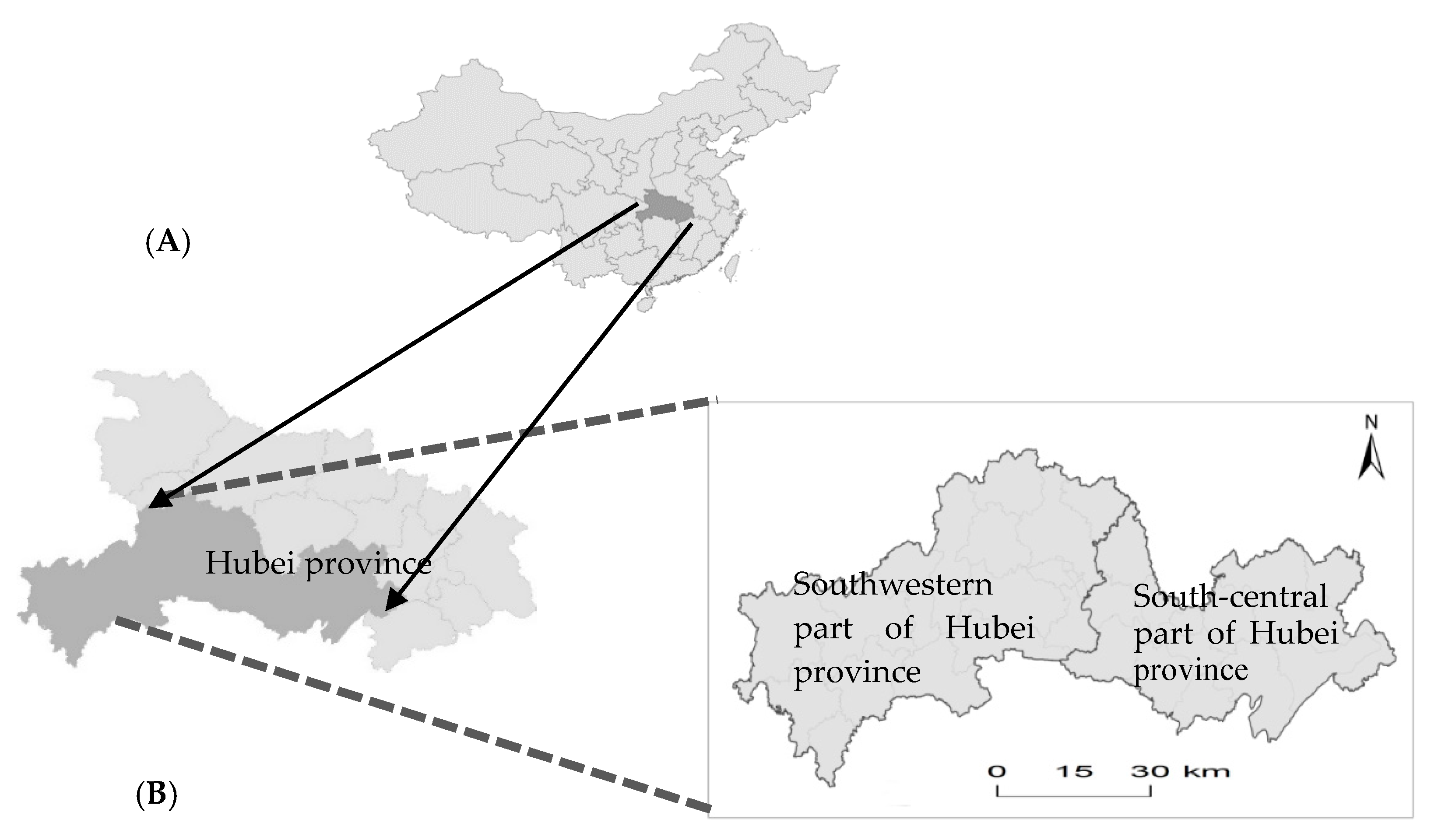
The purpose of this study is to build a comprehensive assessment framework (CAF) of UCL for the south-central and southwestern portions of Hubei Province in China. The specific aims of this study are: (1) to identify the most useful socioeconomic indicators in the assessment by incorporating the natural factors [
1]; (2) to design a comprehensive approach to achieve the objectives of land-quality evaluation and monitoring the quality of UCL; and (3) to explore the basic characteristics and spatial distribution of CLQ within the study area, as well as the degree of spatial differentiation, the limiting factors and the reasons underlying these patterns. The focus will be on how to conductive to the sustainability of land use and comprehensive management systems through conceiving the land-protection strategies.
4. Conclusions
Evaluating and monitoring land quality is a complex and challenging undertaking [
17]. It has become an important activity in China because of the requirement of identify the changes and the natural, socioeconomic attributes of UCL to protect land without specific decisions to perform project investment and land consolidation.
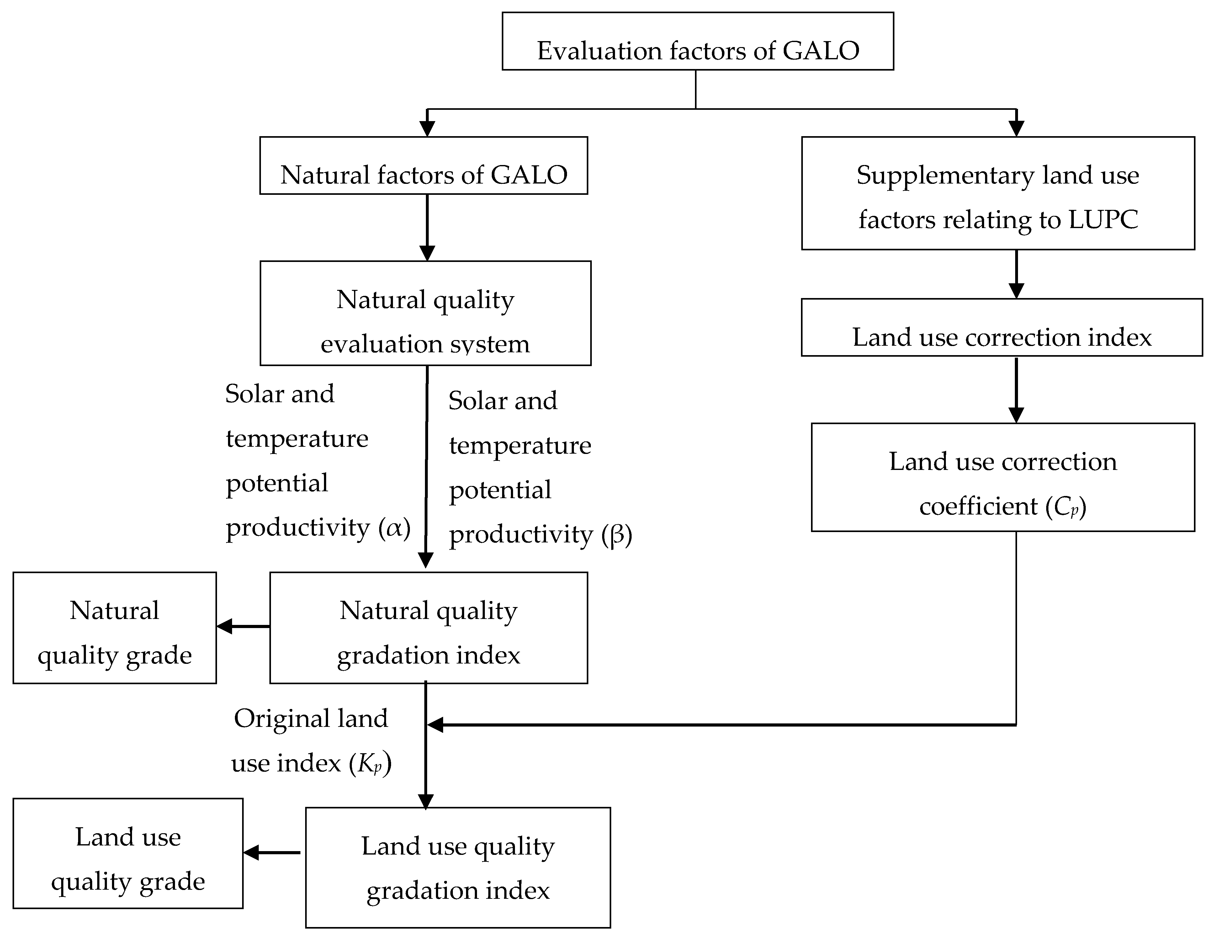
This paper establishes a proper comprehensive assessment framework of UCL for the south-central and southwestern portions of Hubei Province in China using the GALQ method. Assessment supplement 12 proposed land use indicators on the basis of the natural factors of GALQ. The weights are determined by the improved model of fuzzy Analytic Hierarchy Process (FAHP). The scores are determined by Natural breakpoint method to standardize the factor values and assigned different grades, which are implemented by ArcGIS. Use the coefficient correction idea, we complement the LUPC into calculating of land use correction index, re-divide the grade of CLQ.
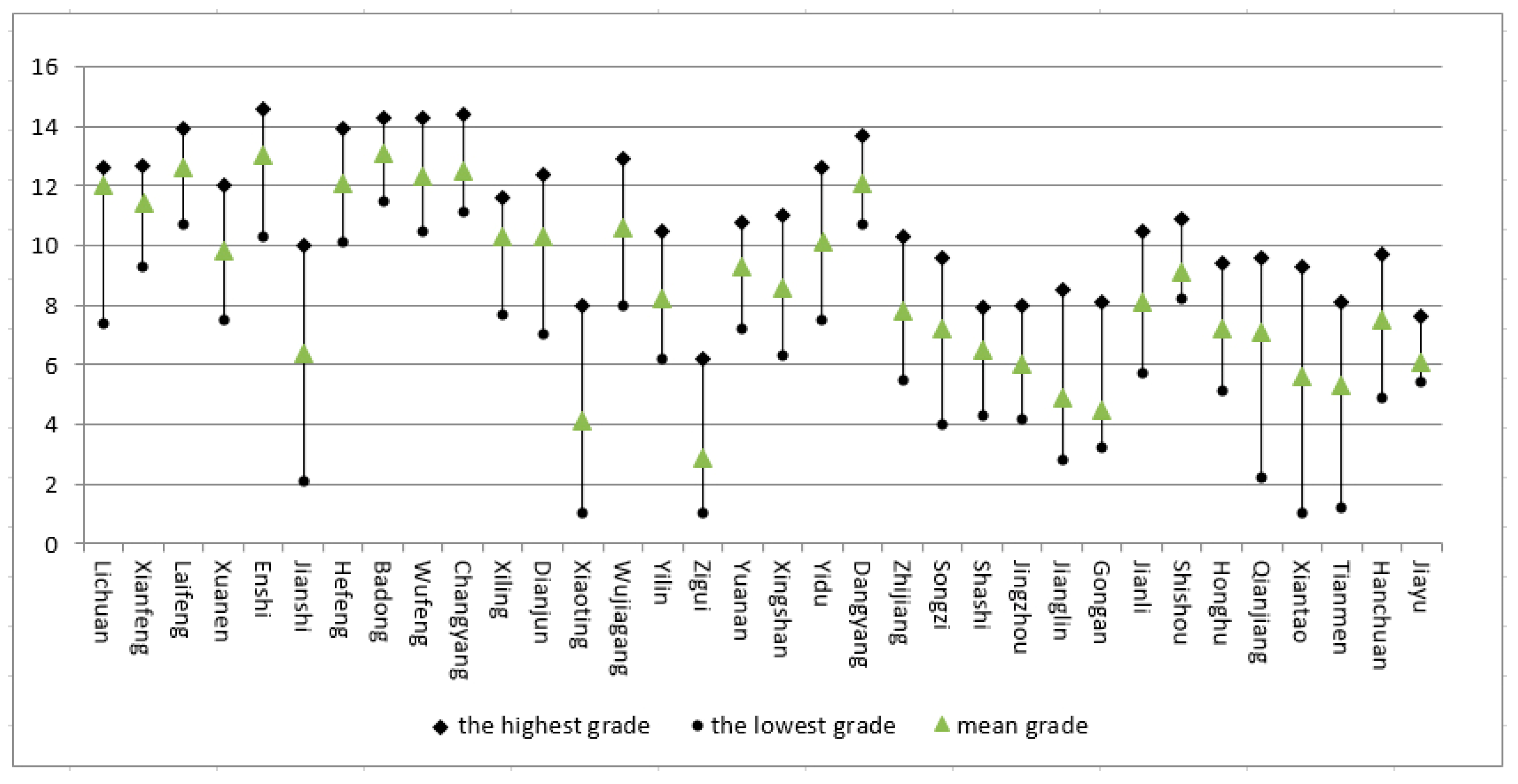
The overall level of CLQ in the study area was moderate, slightly higher than the national average. Assessment supplement 12 proposed land use and production indicators and used the land use coefficient correction method to identify the external factors that cause the spatial variability within the study area. The CV is the most commonly used measure of soil variability [
45,
55]. It found that the spatial differences in the CV in mountainous areas is greater than that in plain areas, and the natural attributes of cultivated land resources are still the main factors that restrict the quality of UCL. In addition, the small-scale agricultural development pattern, which depends strongly on the labor force, was the key extrinsic factor restricting the improvement of regional comprehensive CLQ. The resulting fragmentation of the cultivated land, the disintegration of the farmland road network, and the intensive development of the highway network associated with urbanization are important factors that restrict the convenience and stability of cultivated land use.
The National Resource Inventory assessments are conducted at five-year intervals [
56], as not all of the soil quality factors vary significantly with land use [
56]. Since we have not investigated whether the changes in the LUPCs are significant, two-year intervals are proposed for monitoring UCL.
This research provided adequate information on land-quality differences, as well as the spatial variability and characteristics of extrinsic factors among different management systems, as the outcomes are comparable at different locations. This study provides a valid basis for achieving a national balance in the requisition and compensation of cultivated land and perform in gland management of UCL. This study makes a significant contribution towards providing the theoretical and technical references that are needed for the national project of the evaluation and monitoring of UCL.
Further study is needed to determine whether using ecological indicators. It can be used to evaluate the comprehensive quality of UCL to achieve the coordination of cultivated land production and ecological functions. We suggest that a decision support [
47] from the environmental department to arrive at better informed land management decisions.


