Challenges and Proposals for Socio-Ecological Sustainability of the Tagus–Segura Aqueduct (Spain) under Climate Change


1
Interuniversity Institute of Geography, University of Alicante, 03080 Sant Vicent del Raspeig, Spain
2
Department of Physical Geography and Regional Geographical Analysis, University of Alicante, 03080 Sant Vicent del Raspeig, Spain
*
Author to whom correspondence should be addressed.
Sustainability 2017, 9(11), 2058; https://doi.org/10.3390/su9112058
Submission received: 20 July 2017
/
Revised: 4 November 2017
/
Accepted: 5 November 2017
/
Published: 9 November 2017
(This article belongs to the Special Issue Social-Ecological Restoration for Coastal Sustainability)
Abstract
:Since its inauguration in 1979, the Tagus–Segura Aqueduct has become one of the hydraulic infrastructures that has had the most significant socio-economic repercussions in Spain during the past few decades. The aqueduct is significant for its strategic importance and developmental potential for south-east Spain, where it provides water for agriculture as well as for tourism and urban consumption. The aim of this study is to analyze the uncertainties regarding the future functioning of this infrastructure in view of the reduction of water resources and a higher frequency of drought episodes due to climate change. To this end, an analysis was performed on previous studies of hydrological plans, regulations and studies on climate change in order to enable an assessment to be made of the possible effects of these changes on the normal functions of the Tagus–Segura Aqueduct. Consideration is also given to the new management rules that have regulated this infrastructure since 2014, the use of alternative water resources, and proposals such as measures to increase resilience in light of future climate change scenarios and their effects on the Mediterranean.
1. Introduction
The worldwide uneven distribution of water resources and demand has frequently led to water shortages, and regional demands often exceed supply even in countries with an abundance of water [1,2]. In view of the strong socio-economic growth experienced globally by developed countries during the second half of the last century, numerous water-infrastructure projects have aimed to increase water supply to guarantee considerable expansion of urban and agricultural uses and hydroelectric production [3]. The adoption of the Interbasin Water Transfer (IBWT) has been an age-old method for alleviating and even resolving the urgent demand of water-deficient areas [4]. IBWT projects across national and regional boundaries have been well developed in order to overcome water deficits, and to increase the resilience of the global water system [5] in countries and regions such as China [6,7], the United States [8], Australia [9], South America [10,11], etc.
There are many examples of IBWT. Snaddon et al. [12] identified more than 100 transfers in nearly 30 countries, most of which have been completed and commissioned. Ghassemi and White [13] counted more than 50 (including finished projects and proposals) in just five countries (USA, Australia, Canada, China and India), of which initiatives such as the Central Valley Project planned in 1933 in California (USA) to provide water for irrigation and supply in the Central Valley of California [14], the Snowy Mountains Scheme (Australia) [15], and China’s South-North Water Transfer Project (SNWT) [2], the world’s largest transfer, are of great significance.
A number of countries have made attempts to adopt this approach and have achieved enormous benefits [13]. The implementation of water transfers was one of the most common alternatives during the last century for increasing water supply, but has also given rise to the highest number of socio-regional conflicts between donor and recipient basins [16,17,18,19]. The conflicts caused by transfers have been directly linked to a feeling of unfairness in the decisions regarding the allocation of water resources and, increasingly, to defending the environmental and heritage values of the donor basins [20]. According to Zhuang [17], the objective reality of uneven water-resource distribution and unbalanced water demand by human society has made water transfer inevitable. Zhuang [17] further explained that such changes were two-sided: (1) positive impacts including adding new basins for water-deficient areas, facilitating the water cycle, improving meteorological conditions in the recipient basins, mitigating ecological water shortage, repairing the damaged ecological system, and preserving endangered wildlife and flora; and (2) negative impacts such as salinization and the aridification of donor basins, damage to the ecological environment of the donor basins and both sides of the conveying channel system, increased water consumption in the recipient basins, and the spread of diseases, etc. Furthermore, Zhuang [17] argued that there are some effective alternative measures for IBWT, such as attaching importance to the water cycle, improving water-use efficiency, developing seawater desalination, and rainwater harvesting technology.
During past few decades, protests have extended to developing countries, and today the fight against large dams and transfers constitutes one of the hotspots of socio-environmental conflict in Latin America, Asia, and Africa [21]. In South America, Hommes and Boelens [11] analyzed how urbanization processes and associated rural-urban water transfers in the Lima region (Peru) created water control hierarchies that aligned the municipal drinking water company, hydropower plants, and rural communities in unequal positions. They also concluded that, more specifically, and beyond questions of outright water grabbing, perceived injustices involved the distribution of water-related benefits, loss of autonomy, and the socio-environmental impacts of territorial transformations. In China, IBWT projects effectively overcame water shortages resulting from the uneven distribution of water resources and demand; however, these projects may also create water conflicts between the water source and receiving areas [2]. For example, Rogers et al. [6] showed how the South–North Water Transfer Project (SNWT) naturalized water scarcity, normalized the pre-eminence of northern China, sustained engineering over regulatory solutions, and reconfigured hydro-social relations, whilst also outlining the limits and endemic conflicts within this vast government program.
In Europe, the Water Framework Directive (WFD 2000/60/EC) has led to the consideration of water-planning alternatives that place greater emphasis on the conservation of water bodies, which has, therefore, (according to some authors) in turn led to a reconsideration of the subject of water transfers, owing to their considerable economic and environmental impact [19]. In our case study (Spain), according to Hernández-Mora et al. [18], semi-arid and drought-prone areas have managed to meet ever-increasing water demands for more than 50 years through the construction of publicly funded hydraulic infrastructure. In Spain, IBWT are the most expensive and complex supply-side tools used and are also the most controversial, often associated with such unintended consequences as deteriorating freshwater ecosystems, disappearing recreational opportunities provided by aquatic ecosystems, and the loss of development opportunities for downstream communities [16]. This situation has become increasingly unstable over the past decade due to the scarcity of new supply augmentation alternatives, political changes involving European Union environmental legislation, new political powers in upstream regions, and the appearance of new stakeholders at the decision-making table. As a result, competing demands over available resources and interregional conflicts are delaying water planning efforts, thus signaling the end of an era and demanding a shift from the competitive use of water towards a shared water risk and trade-off governance approach [18].
Added to this is the uncertainty regarding future water resources in the context of global warming due to the anthropogenic greenhouse effect [22]. In this sense, climate change and the resulting changes in hydrology have already altered, and are expected to continue to alter, the timing and amount of water flowing through rivers and streams in the future [14,20,23,24,25]. For this reason, adaptation to climate change is one of the biggest challenges in society and has been growing in importance since the beginning of the 21st century [26].
The aim of this study is to analyze future changes in the normal operation of the Tagus–Segura Aqueduct (TSA) in view of future climate change scenarios, and to propose corrective measures and implement strategies in order to alleviate its effects (proposals and alternatives).
The article is structured as follows. Section 2 presents the methods and materials; Section 3 provides an explanation of the study area and describes the functions of the TSA, paying special attention to the history of transfers and its use and new regulations for use. Section 4 presents our results. Section 5 presents our discussion and debates uncertainty about the functioning of the TSA owing to the effects of climate change and the introduction of new, more conservative, management rules, as well as proposals to mitigate such effects and increase the future resilience of the recipient basin in the light of a possible reduction in transfers. Finally, conclusions are presented in Section 6.
2. Materials and Methods
Methodologically, different materials and steps were consulted to achieve the aims proposed for obtaining the results (see Appendix A):
- (1)
- Donor basin (Tagus Management Plan 2015/21–Royal Decree 1/2016 (8 January)) and recipient basin (Segura Management Plan 2015/21–Royal Decree 1/2016) management plans were analyzed for examinations of water demand and available water resources.
- (2)
- Different regulations that have a direct influence on the functioning of the TSA were consulted: the Water Framework Directive (Directive 2000/60/EC); Law 10/2001 (5 July) regarding the National Hydrological Plan (PHN); Royal Decree-law 2/2004 (18 June), which amended Law 10/2001 (5 July) regarding the National Hydrological Plan; A.G.U.A. Program (2004) (Actions for the Management and Use of Water, Royal Decree Law 2/2004); Law 21/2013 (9 December) regarding environmental assessment; Royal Decree 773/2014 (12 September) (Memorandum); and Law 21/2015 (20 July) regarding forestry.
- (3)
- (4)
- Meetings were conducted with the Sindicato Central de Regantes del Acueducto Tajo-Segura (SCRATS), which is the main association of irrigators in the south-east of Spain (recipient basin). Data and information were provided by this association on water supplies from the TSA (1979–2016) to users (for irrigation and urban uses), current problems and challenges, and possible solutions for the reduction of transfers to this infrastructure. Secondly, information was provided about the social, economic and environmental repercussions of the TSA upon the development of the recipient basin. Thirdly, historical data about water stored in the headwater reservoirs of the TSA (Entrepeñas and Buendía) were provided (1979–2016).
- (5)
- Using data on the water stored in the headwater (1979–2016) and the reduction of precipitation in the donor basin (−7%), according to the Tagus Water Management Plan 2015/21–Royal Decree 1/2016 (8 January), a simulation of the reduction in stored water was conducted and analyzed that considered the old (240 hm3) and new level (400 hm3) of “no transfer” of the TSA.
- (6)
- Finally, possible solutions and alternatives were proposed to guarantee the supply of water and reduce the vulnerability of both basins by taking into account the effects of climate change. Detailed analyzes of these proposals were conducted by considering different scenarios, types and durations of actions, environmental impacts, the benefits and costs, and the stakeholders involved. These proposals were analyzed in an effort to offer a solution that could be applied in other territories and countries with similar water scarcity problems and challenges.
3. Case Study
To guarantee water demands, the south-east of Spain—the area that benefits from the TSA—has made use of traditional solutions, such as transfers and the exploitation of aquifers, together with an increased use of non-conventional sources (desalination and treated reused water) and higher efficiency in the use of water for irrigation and supply [29,30]. All of this should be correlated with the intrinsic characteristics of the recipient basin of this transfer (the Segura basin), which is characterized by an extreme natural scarcity of water resources due to climatic, hydrographic, and hydrogeological factors [31].
The Segura basin, which has climatic situation not subject to drought, has a volume of 1636 hm3/year (860 hm3 surface water, 540.7 hm3 groundwater, 158 hm3 desalinated water and 78.3 hm3/year reused treated water); however, demand is much higher (some 1726 hm3/year). For irrigation, this figure amounts to 1487 hm3/year (86%), followed by urban use of 189 hm3/year (11%), golf courses of 11.3 hm3/year (0.75%), environmental flows of 29.6 hm3/year (1.7%), and industrial use of 9 hm3/year (0.5%). Thus, in view of current levels of exploitation and with the basic premise of agricultural or urban-tourism needs not increasing, the Segura basin accumulates a water deficit of between 400 and700 hm3/year [32]. With ample optimization of non-conventional resources (reuse of treated water and desalination) and with a more efficient management of demand, these water requirements could be between 275 and 575 hm3/year (depending on the rainfall situation). This large imbalance between water supply and demand is due, above all, to the natural scarcity of water resources, the intensification of consumption, and the qualitative changes that have affected its use since the second half of the 20th century [33].
Built in 1979 with a maximum annual transfer capacity of 600 hm3/year in origin (however, 540 hm3 in destination due to losses: evaporation, infiltration, etc.), the TSA (Figure 1) consists of a channel of 286 km in length that begins in the Bolarque reservoir (35 hm3) on the river Tagus, downstream from the headwater reservoirs (Entrepeñas 804 hm3 and Buendía, 1638 hm3). The transfers are intended for urban uses (110 hm3), irrigation (400 hm3) and for supplying the province of Almeria (30 hm3). From Bolarque (after pumping in Altomira), the water is situated in the La Bujeda reservoir (884 m above sea level), which is the starting point for the transfer canal (with a capacity of 33 m3/s) towards the hyper-reservoir of Alarcón (1112 hm3) on the river Júcar; and from there to the Talave reservoir (39.11 hm3) on the river Mundo, the principal tributary of the river Segura. This latter reservoir marks the starting point for the “Post-transfer” complex, which constitutes the set of structures built for the transport, regulation and distribution in the Segura basin of water from the TSA. The regulation work corresponds to the main diversion dam of Ojós, the regulating reservoirs of El Mayés and Crevillente, the reservoir of La Pedrera (246 hm3), and the elevations of Ojós, Alhama de Murcia, Blanca, and Fuente Álamo. The main distribution canals are the Canal of the Right Riverbank (including the Almeria Canal up to the limit with the Southern Basin), the Canal of the Left Riverbank (Crevillente Canal and feeder for the reservoir of La Pedrera), and the Campo de Cartagena Canal.
To date, the contemplated transfers of 600 hm3 have only been reached in one water year, 2000/01. Until then, for irrigation, the corresponding 400 hm3 had never been reached, with a maximum of 377 for the 1986–1987 period. Naturally, with drought in the donor basin (Tagus basin) the cuts were far greater (Figure 2). In this respect, it is appropriate to point out that in 1992–1993, the transfer for this purpose was reduced to 185 hm3 and to just 115 hm3 in 1993–1994 [32]; and since the aqueduct began operation in 1979, the average transfer has been 330 hm3/year, only being considerably higher in the periods 1995–2004 and 2008–2014.
The TSA has had considerable economic consequences in the donor basin of the Tagus. Initially, the villages around the Entrepeñas and Buendía reservoirs were the first to suffer the impacts of the loss of their fertile fields as a consequence of the construction of these reservoirs in the middle of the last century, at a time when agriculture was the principal source of income. Subsequently, these villages developed an economy based on tourism and the leisure use of the reservoirs, around what was known at the time as the “Sea of Castilla”, but these new resources have been affected by fluctuation in the flows, linked to droughts and the transfer of volumes to the south-east of Spain [35]. In this respect, according to Estevan and La Calle [36], since 1980 the resources available in the headwaters have decreased by approximately 47.5%. Thanks to the operation of the TSA in January 2000, a Collaboration Protocol was signed between the Ministry of the Environment, the Regional Government of Castilla-La Mancha, and the Hydrographic Confederation of the Guadiana to connect a drinking-water supply to 33 population nuclei in the donor basin (the provinces of Cuenca, Albacete, and Ciudad Real). Furthermore, with the TSA, there has been an increase in the donor area of so-called environmental demands. This was reflected (thanks to allocations contemplated in Law 13/87) in the diversion of water from the upper basin of the Tagus via the TSA to the National Park of the Tablas de Daimiel (Castilla La-Mancha) owing to the decent water table, which was the result of the overexploitation of aquifers by irrigation wells, that allowed transfer to this wetland of up to 60 hm3 every three years, while not exceeding 30 hm3/year. Since 1987, a total of 256 hm3 has been diverted for environmental uses to this National Park. Furthermore, the irrigators of south-eastern Spain argue that the water transferred was only a surplus in the Tagus basin, that is, the water leftover after attending to all priority demands (including environmental) in the donor basin.
In the recipient basin, the TSA has enabled socio-economic development (agricultural activity and supply for urban and tourism uses). The TSA, in years of normal rainfall, not only supplies approximately a third of the total resources of the Segura basin, but also currently benefits some 145,000 ha of horticulture and fruit for export comprising 54,121 ha of vegetables, 53,706 ha of citrus fruits and, owing to its higher output and economic and social impact, 1603 ha of cultivation under plastic. All of this has an annual repercussion on national gross domestic product (GDP) of about 2.364 billion euros, and supplies water to 80,000 irrigators, enabling 104,000 direct jobs [34]. In this respect, of the 11.903 billion euros marketed in vegetable and fruit exports in Spain in 2015, 42% was marketed in the area benefitting from the TSA. Especially significant is the case of the vegetables in this region, which represent 68% (3.286 billion euros) of the vegetables marketed in Spain [37]. Furthermore, these water transfers guarantee supply to more than 2.5 million inhabitants in the recipient basin (the provinces of Almeria, Alicante and Murcia, with a nearby area of influence of 20,000 km2) that can increase by a million in the summer tourism season [38].
With regard to management rules, the Government of Spain has introduced a series of amendments in water legislation via the Environmental Assessment Law (Law 21/2013, 9 December), which has substantially modified the way the TSA functions. These new management rules were established by the fifteenth additional provision of the Law 21/2015, 20 July in Forestry and by Royal Decree 773/2014, 12 September, which approved various regulatory rules of the TSA. Moreover, they have been included in a memorandum between the Spanish Government and the Autonomous Communities of Murcia and Valencia (recipient basin), and were subsequently joined by the Communities of Castilla-La Mancha, Madrid, and Extremadura (donor basin) [39].
Law 21/2013 (9 December) on Environmental Assessment introduced significant amendments in the regulation of the TSA, giving preference to the donor basin and respecting the determinations of its hydrological planning. In principle, their aim was to improve the regulation of this infrastructure, establishing objective technical rules that eliminated previous insecurity and precariousness and that provided objective and transparent criteria regarding the manner in which these transfers operated. Justification for these new amendments (in force since 1 October 2014) was sought in the new hydrological planning arising from the transposition of the Water Framework Directive (WFD 2000/60/EC), which established that by 2015, the “good ecological condition of the water bodies” should have been achieved. Among the measures introduced, it is appropriate to mention those relating to the volumes stored in the headwater reservoirs (Entrepeñas and Buendía). The volumes to be transferred depend on the total levels of these reservoirs at the beginning of each month, and different levels are established for the monthly transfers, with a total yearly maximum of 650 hm3 in each water year (600 hm3 for the Segura and 50 hm3 for the Guadiana).
The new management rules of the TSA have meant that the minimum “no-transfer” threshold has increased from 240 hm3 to 400 hm3, when this volume is reached in the headwater reservoirs of Entrepeñas and Buendía (total storage of 2494 hm3). The average monthly volume stored in the headwaters during the last decade has been 620 hm3, but this figure varies considerably depending on drought and the rainfall bonanza. Furthermore, it has been accompanied by a substantial amendment of management rules, particularly under exceptional hydrological conditions (in Royal Decree 2530/1985) moving decisions regarding transfer from the Central Management Commission to the Council of Ministers, which set the limit between levels 2 (transferable volume of 38 hm3/month) and 3 (transferable volume of 20 hm3/month) (Table 1).
4. Results
4.1. Effects of Climate Change and Reduction of Water Supply in Spain
Spain is a country that is especially sensitive to the effects of global warming [40]. Owing to its position in the south of the area of general circulation from the west, its proximity to the subtropical subsidence that favors the frequent development of stable weather types throughout the year, especially in the warm summer months, means that precipitation levels in the southern regions of the Iberian Peninsula are not high. This means that surface water resources are closely related to the location of the headwaters of rivers in reliefs well exposed to flows of atmospheric circulation that provide precipitation (water or snow), the routes of which cross regions with high evaporation rates throughout the year, generally, in summer (Table 2).
The global warming process, which has been recorded and evidenced in recent decades, may have three direct effects on water resources in Spain and, therefore, in the context of the water management analyzed here, the rivers Tagus and Segura (see Table 3 and Table 4):
- Reduction of rainwater contributions and, therefore, of the available water resources, accompanied by an increase in temperatures and potential evapotranspiration.
- Changes in the seasonal nature of precipitation.
- Increase in the irregularity of rain, which would bring about an increase in extreme events (droughts and events of large volumes of rain in a short time).
With regard to the first aspect, in the last three decades a reduction was recorded in mean annual supplies (hm3/year) in all Spanish river-basin districts. Comparing data on annual supply between 1996–2005 in relation to the mean values of the 1940–1995 period, this reduction amounts to 14.3% for the country as a whole, with higher values for this reduction (above 20%) corresponding to the water basins located in the southern half of the Iberian Peninsula and on the Mediterranean coast. For the two river basins that make up the Tagus–Segura system, the reduction in supply was −14.4% (Tagus, from 10,533 to 9012 hm3/year) and −38.2% (Segura, from 817 to 505 hm3/year), the latter district having suffered the largest reduction of all the Spanish river basins [41]. Therefore, from the time of design of the TSA to date, water resources in both basins have decreased. This has been corroborated by different authors who point to a clear change in precipitation patterns in the last 20 years in the south-east of the Iberian Peninsula, with a reduction of 15%, an increase in dry periods, and a decrease in the number of rainy days [42].
Added to this is the possible impact of global warming on the future development of precipitation in Spain. The regionalized climate change scenarios prepared by the Spanish Meteorological Agency, AEMET [27], point to a considerable reduction in precipitation in the territories of the river basin districts of the Tagus (between 10% and 15%) and Segura (between 7% and 17%), as shown in Table 3. As well as the annual number of rainy days (in the Tagus between 10 and 20 days and in the Segura between 5 and 10 days), an increase in temperatures of 1.7–6 °C in the Tagus and 1.7–5 °C in the Segura [28] estimated in the climate projections with a 2100 horizon will lead to an increase in evaporation in the Tagus and Segura basins, especially in warmer months, owing to the increase in days with high temperatures, in a critical period for water supplies (Table 4).
At the start of the current water planning process imposed by the Water Framework Directive, the approval of the Hydrological Planning Instruction (Order ARM, 10 September 2008) established values for the reduction of the natural water supply that should be incorporated in the projections of available water resources for forthcoming years (2017 horizon) in each of the river-basin districts. For a scenario in the year 2027, a decrease in the natural water supply in Spain, due to the reduction in precipitation, would vary between 2 and 3% in the districts in the north of the Iberian Peninsula and 11% in those further south (Segura and Guadiana). In the Tagus basin, a decrease of 7% was established. The application of the values of reduction in the natural water supply in the different river-basin districts in scenarios of normality, abundance of rain, and drought, in comparison with the water demands in each (River Basin District Plans) reflected that in many of these areas the resources will be lower than demands, and not only in drought years [43].
In their water planning proposals for the Second Planning Cycle (2015–2021), the Tagus and Segura River Basin District Plans have handled the reduction due to a reduction in precipitation of water-resource percentages of 7% and 5%, respectively. In the case of the Segura River Basin District, the values of existing resources for the planning horizons 2021 and 2033 may be considered as overestimates in relation to those stated by the Hydrological Planning Instruction of 2008. However, when performing an overall assessment of the effects of this reduction in water resources in the Tagus and Segura river-basin districts, it was necessary to analyze the demands contemplated in each district for the planning horizons of 2021 and 2033. Table 5 summarises the data on the evolution of water demands in the Tagus and Segura basins, as well as the available resources (taking into account the contemplated reduction from the HPI and District Plans) using what is known as the short series (1980–2012), the statistical trend that projects a greater reduction of supplies. It should be pointed out that in the Tagus basin, the situation of surface resources is compromised with regard to the satisfaction of demands of the basin in years of drought, and will be more so in view of the reduction in precipitation forecast by the climate change model [25].
Two other aspects of rainwater behavior that would also be altered (seasonality and irregularity) also cause concern in terms of water planning. One of these is the change in the seasonal nature of rain, which has been shown to be real in recent decades. Indeed, De Luis et al. [44] pointed to the change in seasonal rain patterns, with increased amounts in the autumn months, when compared to spring. In our study, this was common in the territories of the Segura and Tagus river-basin districts, with a special incidence in the latter, which in the 1946–1975 period had a significant contribution of spring precipitation which lost its importance in the 1976–2005 period. In middle latitude locations such as mainland Spain, autumn rains usually fall in heavy bursts, which means that they are not very useful as a water resource; on the contrary, they cause economic losses, since they lead to overflow and flooding [45].
Finally, it should be pointed out that another of the possible effects of global warming on precipitation in Spain will be the increase in irregularity, apparent in the greater frequency of episodes of drought and heavy rains. These atmospheric phenomena, apparently contradictory, are a feature of subtropical climates, such as the Mediterranean and, as shown by climate change models [22], will increase in forthcoming decades. Therefore, there is a great need for water planning proposals to take into account this more irregular behavior of precipitation in order to safeguard water use in the territories of the Tagus and Segura.
From the moment the TSA was designed in the late 1960s, the headwater of the river Tagus has experienced a reduction of natural contributions of about 30%. The contribution in this stretch of the river has gone from an average of 1543 hm3/year for the period 1940–1979 to 1026 hm3/year for the period 1980–2011. The average volume of water transferred from the Tagus to the Segura accounts for 35% of the average volume stored in the reservoirs of the headwater (Entrepeñas and Buendia). However, in years of intense drought (for example, 1997–1999, 2003–2004, 2005–2009, and 2015–2017), the volume of water transferred to the Segura basin amounted to 70–80% of the total water stored in these reservoirs, which consequently impacted on the lack of flow downstream in the donor basin [46].
Within the framework of projections for the reduction of precipitation and volume of water available in the Tagus basin, annual transfers to the recipient basin will be seriously compromised. The TSA Memorandum (approved in 2013) contemplates a minimum volume of water stored in Entrepeñas and Buendía of 400 hm3, below which it is not possible to make any monthly transfer to the recipient basin. Since 1979, the reservoirs of Entrepeñas and Buendía (whose total storage capacity is 2494 hm3) have had an average stored monthly volume of 783 hm3. This means that this volume is lower during periods of drought when the stored water was under 400 hm3 (for example, the last important episodes of 2005–2009 and the current period of 2015–2017). Therefore, possible scenarios of a reduction in precipitation and available water resources, more intensive droughts, and increased water demand in the donor basin (see Table 5) have had a direct influence upon the normal operations of the TSA in addition to the new rules of exploitation to guarantee water supply in the Tagus basin.
4.2. Critical Aspects and the Effects of the New Rules on the Exploitation of the Tagus–Segura Aqueduct from a Climate Change Perspective
Taking into account the history of the volume of water stored in the headwater reservoirs of the Tagus (1979–2016), Figure 3 shows the direct repercussions on the reduction of such flows, by considering the effects of climate change on the donor basin (−7% of reduction of precipitation). Additionally, the former no-transfer limit (240 hm3) and the new limit of 400 hm3, are also shown, and have been in force since 1 October 2014. This shows a reduction in the volumes stored in the headwater reservoirs since the end of the 1970s, which were named the “Sea of Castile” and led to the growth of the surrounding villages as tourism and leisure resources. In this respect, Estevan et al. [47] highlighted how, since 1980, the available resources in the headwaters of the Tagus have diminished by approximately 47.5% by taking into account the “80 effect”, which considered the decrease in precipitation (rain and snow). It is also appropriate to explain that the drastic reduction of volumes stored after 1980 was due to the transfer of 1200 hm3 for hydroelectric production, which aggravated the severe drought suffered by the south-east of Spain by preventing the transfer of these resources to the Segura basin [47].
Furthermore, a determining factor to be considered is the new allocation of resources that will be borne by the headwater reservoirs of the Tagus, estimated by the Tagus Axis Model at 230.82 hm3/year in the stretch between Bolarque and Aranjuez. The pressure on the headwater resources was notably increased in the previous Tagus Management Plan (2013) with the inclusion of new demands for the supply of the Algodor and Girasol Commonwealths (20 hm3), Upper and Lower Sagra (20 hm3), and Canal de Isabel II (60 hm3). To a large extent, this strong growth in demand (at 100 hm3/year) responded to an increase in the consumption of drinking water (that was forecast a decade ago) for new and extensive urban developments in the south of the Metropolitan Area of Madrid and in areas such as Sagra (a province of Toledo). Furthermore, it should be noted that the new Tagus Management Plan (2016) specified that the strong demographic growth of the Community of Madrid and Castilla-La Mancha must be supplied from resources regulated in the headwater (Entrepeñas and Buendía reservoirs) since no other possibilities are available to them. This plan envisaged an increase in the water demands in the headwater of the river Tagus by almost 200 hm3 between 2015 and 2033, particularly in urban demands, which will increase from 741 hm3 to 931 hm3, and industrial demands from 42 hn3 to 61 hn3. On the other hand, another factor that has influenced the decrease in stored volumes has been the transfers to south-east Spain. Despite the fact that the TSA is capable of transferring an annual maximum of 600 hm3, this figure has never been reached, with average transfers between 1979 and 2016 being 330 hm3/year.
Regarding the new management rules (no-transfer limit of 400 hm3), it can be appreciated that had these rules been in force since 1979, the TSA would not have been used on numerous occasions (1983–1984, 1992–1993, 1995–1996, 2005–2007, 2008–2009, and 2015–2016) (Figure 3). This is due to the fact that the new management rules are more conservative and adapted to new needs and realities that were more objective and fairer to the donor basin than previous ones. The average volume of water stored in the headwater during the period 1979–2016 was 783 hm3 and, if a reduction of 7% was applied, the volume of water stored would be 728 hm3. This means that if a hypothetical reduction of 7% in the Tagus basin is taken into account, in practical terms this reduction would not entail a substantial change in the normal functioning of the TSA. However, if this reduction threshold is considered, the transfer would be closed, taking into account both the real volumes and the hypothetical values of the precipitation reduction.
Furthermore, it can be seen that, in these four decades of operating the TSA, several cyclical episodes of drought have occurred (1980–1985, 1992–1995, 2004–2009 and 2014–2017), that is, periods of “structural drought” that have affected the headwater of the river Tagus every 8–10 years. Therefore, it can be concluded from this analysis that the function of the TSA is not so much conditioned by the effects of the reduction in precipitation, as by the succession of drought episodes; the new, more conservative and fairer management regulations in favor of the donor basin; and by increases in water demand in the headwater of the Tagus.
5. Discussion
As has been emphasized, with the new management rules, the reserves in the headwater reservoirs of the Tagus will frequently be below the no-transfer threshold that was established at 400 hm3. As a consequence, periods of drought would result in situations where no water would be available for the Segura basin as other resources would be needed to guarantee agricultural and urban supply (Scenario 1: Temporal closure of the TSA). Therefore, if other solutions are not proposed in the framework of a new National Hydrological Plan, one of the possible ad hoc alternatives (short- and long-term actions) to the closure of the TSA coinciding with episodes of drought would be to use desalination and treated reused water and favor water trading between the basins of the Tagus, Júcar and Segura with the development of articles 67 to 72 of the Consolidated Text of the Water Law (Table 6). This latter option (public water markets) is well known in the experiences of mitigating the effects of drought in Spain, which was seen in the case of the replacement by irrigators of the Canal del Bajo Alberche of irrigation water from the Alberche river with water pumped from the Tagus by the Canal de Isabel II to guarantee supplies to the city of Madrid during the drought of 1993–1994 and 2005 (31 hm3/year and 0.20 €/m3) [48]. This measure offers up to 623 hm3/year (0.20 €/m3) but depends on the agreements of the different irrigator associations in the donor basin.
With regard to desalination in the recipient basin, this is a resource of vital importance for urban use, while treated reused water should be allocated to agricultural and municipal uses, such as the watering of gardens, hosing of streets, etc. The recipient area, taking in to account the total capacity of production in the main seven desalination plants (350 hm3/year), has never reached this volume due to the high price of water, the high cost of energy, and because the irrigators cannot pay for it [19]. In the words of Swyngedouw and Williams [49], desalination looks set to become the great solution, although at the moment it is economically more expensive and unfeasible for agricultural use unless a political price is applied. In this respect, the province of Alicante (recipient basin) is home to the desalination plant of Torrevieja (completed in 2010), which is the largest in Europe with a production capacity of 80 hm3/year and which began to produce water in 2015 with a capacity of 30%, but with subsidized water until 2018 under the auspices of the Drought Decree for agricultural use with a price of 0.30 €/m3. Furthermore, according to the detractors of the TSA in the donor basin, the desalination plants built on the Mediterranean coast should produce subsidized water (at a price equal to that of the TSA, at 0.09 €). At present this is an unfeasible solution, even though desalination is a strategic resource for circumstantial alleviation of the decrease of other resources (as has occurred with the river Taibilla, a tributary of the Segura) or with the TSA. It cannot be considered as a substitute resource in the long-term, owing to the price (0.09 € compared to 0.60–1 €, respectively) and to energy consumption (1.11 kWh compared to 4.50 kWh, respectively) [19].
Regarding treated reused water, in the Region of Murcia (recipient basin) and given the relevant historical and socio-economic importance of its irrigated agriculture, these resources are considered a fundamental pillar for the maintenance of this sector. It is for this reason that this region is an example of the reuse of treated water for this purpose, since 65% of irrigated hectares (some 100,000 ha) can complete their allocations of conventional resources with this water (99,452,054 m3, 95.5% treated water) discharging into the sea just 4.5% of the treated volume [30]. In the receiver basin, it is appropriate to note the use of these resources: Murcia treats 109 hm3 and reuses 92.08%; and the province of Alicante treats 119.3 hm3 and reuses 71% [30]. However, in the donor basin, the Region of Madrid treats 573.41 hm3 and reuses only 1.98%, Castilla-La Mancha treats 221.26 hm3 and reuses only 0.67%, and Extremadura treats 164.21 hm3 with no volume of reuse due to the bad quality of the purified water [50]. As a short-term action in the recipient basin in the case of drought, there are the options to exploit aquifers that have not been over-exploited (31.8 hm3/year and 0.20 €/m3) and use water from different aqueducts if there are available resources. This is the case with the Júcar-Vinalopó Aqueduct (JVA) (20 hm3/year and 0.20 €/m3), the possible reversible Rabasa-Fenollar-Amadorio Canal (RFAC) (10 hm3/year and 0.17 €/m3), the increase of water transfers of the Negratín–Almanzora Aqueduct (NAA) (21 hm3/year and 0.20 €/m3) (Figure 4), and the restriction of water-consumption uses (garden irrigations, pool-filling, etc.).
In relation to the ecological impacts in the recipient basin, these measures could increase the over-exploitation of aquifers in the recipient basin, reduce water resources in the donor basins of the infrastructures of the Júcar–Vinalopó Aqueduct (JVA), Negratín–Almanzora Aqueduct (NAA) and Rabasa–Fenollar–Amadorio Canal (RBAC), and increase CO2 emissions due to the increase of desalination production in the recipient basin (4.50 kWh/m3 in comparison with 1.11 kWh/m3 of the TSA).
In the second scenario of a reduction of supply in the headwater due to the intensification of drought and water demand in the donor basin, in addition to those measures already mentioned above, a long-term measure could be proposed that might generate controversy in the framework of the State of Autonomous Communities and Water Planning in Spain; this would consist of the rebalance of the headwater, where the “80 effect” has been most patent, and the rainwater catchment area (Gredos mountains) that has sufficient resources of extraordinary quality to guarantee the demands of the Metropolitan Region of Madrid and Castilla-La Mancha. In this respect, it should be cautioned that construction of the TSA overestimated the resources available in the headwater, since it did not make use of appropriate climatic and hydrological information. As a complementary solution, different organizations (irrigators, agricultural and business organizations) in the recipient basin defend a better use of the resources of the Middle Tagus to satisfy the urban demands of Madrid and Toledo, thus reducing the pressure on the upper basin of the Tagus. Furthermore, this solution would not compromise compliance with the Albufeira Convention (1998) since, with the short series “80 effect”, after satisfying all demands the Tagus would deliver to Portugal 6300 hm3/year, when the treaty establishes a volume of 2700 hm3/year.
It is also appropriate to mention measures contemplated in the Common Agricultural Policy (CAP) to respond to better management of water resources (taking into account that agricultural use is the largest by volume) in both the recipient and donor basins. To this end, it would be interesting to observe how the CAP achieves a better allocation of water during situations of drought, or in hypothetical future climate change scenarios. In this respect, it is appropriate to indicate the “payment for practices that benefit the environment and the climate” or “greening”, also known as a “green payment”. This allows an annual payment to be granted per hectare (admittedly linked to a basic payment right) provided that certain environmental practices are respected, depending on the structure of the farm. In any case, farmers who wish to activate their basic payment rights must respect these environmental practices in all the hectares of the farm that are subject to the “greening” requirements. The amount of this payment is a percentage of the total value of the basic payment rights activated by the farmer each year, which is normally slightly more than 50%. This payment will be funded above 30% from the budgetary limit corresponding to Spain. For the year 2015, the budget amounted to 1453 million euros, a figure that will be increased gradually until it reaches 1468 million euros in 2019. The agricultural practices that benefit the climate and environment as specified are: (1) crop diversification; (2) maintenance of permanent grassland; and (3) ecological focus areas (EFAs). In relation to the ecological impact, in addition to those already mentioned above, these measures could improve water-resources management in both basins (“greening”) and the reduction of water-resources pressure on the reservoirs of Entrepeñas and Buendía from the Metropolitan Area of Madrid. In this scenario, the ecological impacts will the same in the Scenario 1 and the improvement of water-resources management in both basins (“greening”) and the reduction of water-resources pressure on the headwater reservoirs from the Metropolitan Area of Madrid due to the rebalance of the headwater.
In the third scenario, there is the option of carrying out a scheduled closure of the current TSA infrastructure. This measure, also controversial, would require the agreement of the two basins (donor and recipient) and entail a series of water compensation measures for the users of the Segura basin, whereby the transferred flows would be replaced by others of diverse origins (desalination) and compensation between 3021 and 9161 million euros would be paid if water is not guaranteed [51]. If the same socio-economic model in the recipient basin continues, there are the options of measures under the Common Agricultural Policy (CAP) (“greening”) to improve the efficiency of agricultural use (in both basins), and a complete replacement of the TSA by desalination (increasing the current capacity of 350 hm3/year to 540 hm3/year). Currently, urban use would be guaranteed (110 hm3/year) but agricultural use would not be guaranteed (only 160 hm3/year). For this reason, the capacity of production for agricultural use should be increased by 240 hm3/year and the price should be subsidized (0.30 €/m3). This measure will incur the government a cost of 120 million euros/year.
In relation to the environmental impact, if the same socio-economic model in the recipient basin continues and meeting all demands will not be guaranteed by desalination, the closure of the TSA would imply greater over-exploitation of groundwater in the south-east of Spain, impoverishing ecosystems in terms of loss of biodiversity and capacity for regeneration. Moreover, intensive exploitation of the aquifers has led in many cases to the salinization of groundwater owing to the recirculation of irrigation waters or the intrusion of seawater. This is the case, for example, in the aquifers of Campo de Cartagena (recipient basin), which in the 1970s pumped up to 120 hm3/year; thanks to the TSA, extractions have been reduced by up to 50% [52]. Also, water from the river Tagus has an indirect impact on the management of salts in the ground, since the salinity of this water is lower than the levels in water applied to fields originating in the aquifers and river, which enables a mitigation of the salinization process in the ground on these lands [52]. Moreover, CO2 emissions will increase in the recipient basin due to an increase in the production capacity of desalination.
On the other hand, if the same socio-economic model in the recipient basin does not continue, the main users of the TSA (SCRATS for agricultural uses and the Mancomnidad de los Canales del Taibilla (MCT) for urban uses) affirm, likewise, that the cancelation of this infrastructure would imply a breach of the regulations of the WFD. This would be both owing to the deterioration of the water mass as its volume and quality are reduced, and because it would affect the ecosystems that depend on them in the recipient basin. The reduction in the flow of water in the rivers would be caused by a loss of external contributions in the flow circulating in stretches of rivers with transfer water and, to a lesser extent, by the loss of irrigation runoff from the areas irrigated with water from the Tagus that surround the watercourses [53]. This scenario (definitive closure of the TSA) would be complex to implement, and would require a massive effort by the authorities to educate the current users of the transferred water in order to change attitudes, behaviors and the socio-economic model developed over decades. However, fortunately, the donor basin will increase the environmental quality and quantity of the Tajo river due to the cancellation of the transfers to the south-east of Spain.
All of this should entail, moreover, a reflection on the future of agriculture in the affected area and, in short, regarding the future of agricultural production in Spain and its regional specialization, an aspect that, to date, the authorities have not wished to consider in all the years that this infrastructure has functioned. The loss of transfer flows should be replaced by a well-planned alternative at the same economic cost in the area of distribution depending on this State structure. In short, this latter scenario poses many uncertainties, aside from the not insignificant conflicts that it would generate in the recipient area and the initially negative economic repercussions if this option is not planned in detail, including minimizing the full economic costs and loss of employment. The most affected uses would be agricultural, and this would require a Regional Development Plan that would need European funding for the whole of the affected area in order to favor alternative forms of production that consume less water.
Any of the scenarios stated would entail, with a view to the future, the decision by central government to establish a national water tariff system to favor the use of desalinated water. Alternatively, the State could provide sufficient economic resources to establish a “political” price for desalinated water, which would collide with the principles of cost recovery of the Water Framework Directive itself. Other solutions include the proposal of a National Water Pact prior to processing a new National Hydrological Plan with measures adaptable to climate change; the achievement of greater involvement of the European Union and State in the funding of water infrastructure for drought situations; the efficient management of water demand and supply with the coordination of sectoral policies (energy, irrigation, and CAP) with water policy (Framework Directive) and regional planning; an increase in the reuse and quality of treated water for developing this conventional resource; an improvement in the connection of desalination plants with the inland of the recipient basin; and an increase in water-efficiency management among the supply entities and users. Moreover, in relation to desalination, it is important to note that transfering water from the coast inland (100 km from the coast, and 500 m above sea level) will increase energy costs and, therefore, the cost of water.
With these proposals, taking in to account different scenarios, both basins will be beneficiaries: an improvement of water-resources management in both basins, and an increase in the environmental quality and quantity of water of the Tajo river (donor basin). Furthermore, to achieve these possible proposals and guarantee a supply of water and socio-economic development in the donor and recipient basins, different stakeholders will be involved: agricultural, urban and industrial users; agricultural associations; political parties; water-supply entities and companies that supply water for urban uses; ecologists and citizens associations; public organizations differentiating between those responsible for basin management (Segura Hydrographic Confederation and Tagus Hydrographic Confederation); and political-administrative bodies (the Departments of the Environment and of Agriculture and Water of the regions of the source and recipient basins, the Public Water Body of the Region of Murcia, the Water Agency of Castilla-La Mancha, and the Price Commission of the Valencian Government).
IBWT inevitably involves the redistribution of water resources in relevant basins and may cause changes to the ecological environment in different basins [19]. Zhuang [17] explained that IBWT implied negative impacts such as salinization and the aridification of donor basins, damage to the ecological environment of the donor basins and both sides of the conveying channel system, an increase in water consumption in the recipient basins, and the spread of diseases, etc. Besides, Zhuang [17] argues that there are some effective alternative measures for IBWT, such as attaching importance to the water cycle, improving water-use efficiency, developing seawater-desalination, and rainwater-harvesting technology.
The TSA is an example from which to learn and compare with other international cases regarding the controversy between basins. In the USA in the 1970s, for example, opposing sides proffered economic (high costs and funding difficulties), social (resistance by the local population to the construction of dams and water transfer), and environmental (impacts on ecosystems) reasons in such controversies. In the Los Angeles Region, the City of Los Angeles (with a population reaching 4 million people) imports nearly 90% of its water from sources outside the city. However, climate change, population growth, competing demands, water-quality concerns, and environmental-restoration projects have all had a large impact on the dependency of Los Angeles on future water importation. Of the five main water sources that supply this area (the Los Angeles Aqueduct, Colorado River, California Aqueduct, local groundwater, and reclaimed water) most will be impacted by climate change, water quality, energy, and cost constraints [20]. Similar consequences and the implications of climate change were argued in Reference [14] in California in relation to water dependence under IBWT. Similar implications can be shown to exist in the study case (south-east of Spain). It is a semi-arid region with an important dependence of water transfers (50% of the water resources available from the TSA), an area with competing demands (tourist vs. rural uses), and controversy around desalination due its high costs. Restoration of the TSA will generate different ecological impacts in the recipient basin as the over-exploitation of aquifers increases and CO2 emissions rise due to the increase in the production capacity of desalination in the Mediterranean in order to replace water transfers for the TSA.
There are other examples in South America (Lima, Peru), where there are social and environmental problems due to a dependence on water transfers to supply the increasing population and the urbanization in Lima [11]; and in Turkey, where there are socio-territorial and environmental problems due to dams and transfer construction [54]. Another example is China [6], where the SNWT Project naturalizes water scarcity, normalizes the pre-eminence of northern China, sustains engineering over regulatory solutions, and reconfigures hydrosocial relations, while also underlining the limits and endemic conflicts within such a vast program of government.
The amendment of the management rules of the TSA has determined a considerable increase in the no-transfer threshold in the headwater of the river Tagus (Entrepeñas and Buendía reservoirs) that also affects the management rules that determine the levels of emergency and alert. Thus, its functioning capacity has been limited in comparison with previous requirements, and for various reasons. First, as the new thresholds increased by 160 hm3 in both the reserve stored in the Entrepeñas–Buendía system (which rises to 400 hm3) and in the monthly curve of levels that serves to dictate exceptional hydrological conditions (Royal Decree 2530/1985), this would reduce the flexibility of the TSA’s operation when situations of intense and prolonged drought occur in south-east Spain. Furthermore, the same atmospheric and rainwater mechanisms that provoke these droughts also affect the headwater of the Tagus, which aggravates their effect in the recipient basin.
The new rules on the exploitation of the TSA provide a very relevant example of water governance; a political pact that sets out to boost the water planning of the Tagus and of the river-basin districts of the Segura, providing legal security and institutional stability to the irrigation and supplies that currently depend on the infrastructure, while respecting in all cases the prevalence of the demands in the donor basin that logically take priority [39]. Melgarejo et al. [39] affirm that, thanks to these new rules, the system will be operated so that the transfer volume already authorized and pending applications will be maintained preferentially in the headwater reservoirs rather than in other reservoirs in transit or destination. Moreover, this is a measure that will favor both basins, since, on the one hand, it benefits the donor basin by retaining the flows to be transferred in its reservoirs for as long as possible, which facilitates better development of the surrounding municipalities (water sports, improved landscapes, etc.); on the other hand, the recipient basin experiences greater losses through evaporation, since the flows deposited in the Segura, and especially in reservoirs such as that of La Pedrera, are exposed to far greater levels of evaporation.
Added to this is the uncertainty regarding future water resources in the framework of global warming due to the anthropogenic greenhouse effect which, in some regions of the world, such as Spain, may cause a reduction in precipitation and, therefore, a reduction in the water circulating in the rivers. All of this means that the future functioning of the TSA is uncertain since, on one hand, a reduction in water resources has been forecast together with an increase in demands in the headwater; and, second, owing to the effects of the new management rules that increased the no-transfer level from 240 hm3 to 400 hm3.
The impact of these three factors will be to condition the normal functioning of the TSA, and therefore, other resources have been assessed (such as desalination) as solutions to replace the water transfers. The increase in demand for water in the donor basin is estimated at about 200 hm3, while the average transfer volume since 1979 has been 330 hm3. Therefore, a proposal has been put forward to substitute such transfers to meet the increased demand for water in favor of the donor basins. Undoubtedly, it would be necessary to achieve greater efficiency in water use, both in the Tagus and Segura basins, and to increase the supply of non-conventional resources (desalination and treated reused water) at a price and quality acceptable to the various stakeholders. Furthermore, it is important to consider the necessity of improving the quality of the treated water, increase efficient management of the water demand and supply, subsidize the desalinated water in the recipient basin, and establish a national water-tariff system that allows the incorporation of the resources provided by the desalination of sea water.
6. Conclusions
Ecological degradation has generally been an unintended consequence of water management, stemming from a lack of understanding of the water flows necessary to sustain freshwater ecosystems. Traditional water management has generally sought to dampen the natural variability of river flows in order to attain steady and dependable water supplies for domestic and industrial uses, irrigation, navigation, and hydropower, and to moderate extreme water conditions such as floods and droughts [55]. In Spain, the operation of the TSA has generated diverse and continuous controversies between the donor and recipient basins. On the one side, those who oppose this transfer from the center of the Iberian Peninsula accuse those in the south-east of appropriating their resources without receiving anything in exchange, and prejudicing the environment with the reduction of ecological flows and socio-economic development. In this respect, Richer et al. [55] affirm that when natural variability in river flows is altered too much, marked changes in the physical, chemical, and biological conditions and functions of natural freshwater ecosystems can be expected. However, in relation to the socio-ecological sustainability of the TSA, there has been an increase in the donor area of so-called environmental demands. This was reflected (thanks to the allocations contemplated in Law 13/87) in the diversion of water from the upper basin of the Tagus via the TSA destined for the National Park of the Tablas de Daimiel (Castilla La-Mancha), owing to the decent water table, which resulted from the over-exploitation of aquifers that fed them due to the opening of irrigation wells that allowed the transfer to this wetland of up to 60 hm3 every three years, while not exceeding 30 hm3/year. On the other hand, the recipients mention the far-reaching socio-economic impact of the uses that benefit from this water. Today, 50% of the productive wealth of the recipient basin of the TSA depends on the contribution of the waters from the river Tagus [29], owing to which these recipient areas should seek solidarity with the donors and never forget their dependence on them. Furthermore, the closure of the TSA would imply greater overexploitation of the groundwater in the recipient basin, impoverishing the ecosystems as they lose biodiversity and their capacity for regeneration. This intensive exploitation of the aquifers has led in many cases to the salinization of the groundwater owing to the recirculation of irrigation water or the intrusion of seawater. Besides, with the closure of the TSA, CO2 emissions will increase due to the expansion of the production capacity of desalination in the Mediterranean in order to replace water transfers.
As argued by Morote et al. [19], desalination and water-transfer schemes are not panaceas in themselves; rather, they should be considered in terms of technological parameters tailored to the circumstances of each geographical and socio-economic environment. In the words of these authors, desalination presents a number of drawbacks that must be taken into account. For example, its high price is still a major problem because these costs are only feasible for urban or recreational uses with high added value or those that are socially necessary. The worst affected sector in this scenario is agriculture, especially farms that are based on traditional irrigation systems, or those using cutting-edge methods [56,57,58]. For this reason, only a subsidized price or parity with the price of other, cheaper methods (existing or viable water-transfer schemes and the use of reclaimed wastewater or rainwater) in a sustainable mix, could convince farmers of the benefits.
What can be learnt from analysis of the Spanish case is that the TSA has enabled the socio-economic development of the south-east of Spain, although this is infrastructure that has been questioned since it was commissioned in 1979 owing to the tensions between the donor and recipient basins. In the south-east of Spain, the use of desalination (National Hydrological Plan, 2001 and Programa de Actuaciones para la Gestión y el Uso del Agua, A.G.U.A. Program, 2004) has become one solution for increasing the supply of water resources in the area, although it is not clear that this is the solution to the lengthy controversy around the TSA. The accuracy of the forecasts for climate change and the reduction of supplies in the headwater of the Tagus, where the “80 effect” has been patent, and the way the new management rules may influence the functioning of this infrastructure, remain to be seen. In addition, greater involvement of the State, the Autonomous Communities, and different political forces would be necessary to achieve a National Water Pact, with measures for adaptation to climate change. Within these consensus measures, the maintenance and/or review of the current transfers, or the possible performance of others of a moderate quantity that could function on the basis of a regulatory development of articles 67 to 72 of the TRLA, should not be ruled out. The Spanish case allows readers to learn about some proposals and solutions to IBWT problems, especially given the implications of climate change, and how to implement it in other countries.
Finally, the goal of ecologically sustainable water management will not be achieved until humans accept that there are limits to water use, and those limits are defined by what is needed by the natural systems that support us. As explained by Richer et al. [55], scientists and conservationists must work hard to define ecosystem-flow requirements that will protect the ecological integrity of the affected systems. Water managers and users must be willing to live within the limits posed by ecosystem-flow requirements even as they undergo further refinement, in order to use available water supplies efficiently, and commit to long-term water planning and adaptive management. For this reason, and taking into account climate change scenarios, we must all search for innovative solutions, tap human creativity to address those areas where there is conflict, and keep working at it until we get it right.
Acknowledgments
The results presented in this article are part of the research project “Uses and management of non-conventional water resources in the coast of Valencia and Murcia as an adaptation strategy to drought” funded by the Spanish Ministerio de Economía y Competitividad (MINECO) under grant number CSO2015-65182-C2-2-P. The authors are grateful for the data provided by the Sindicato Central de Regantes del Acueducto Tajo–Segura (SCRATS) (José Antonio Andújar and Alfonso Botía).
Author Contributions
The three authors wrote the paper.
Conflicts of Interest
The authors declare no conflict of interest.
Appendix A. Laws and Management Water Plans
AGUA Program (2004) (Actions for the Management and Use of Water, Royal Decree Law 2/2004)
Directive 2000/60/EC
Law 10/2001, of 5 July, on the National Hydrological Plan (PHN)
Law 21/2013 of 9 December, on Environmental Assessment
Law 21/2015, 20 July, on Forestry
Royal Decree-law 2/2004, of 18 June, which amends Law 10/2001, of 5 July, on the Nacional Hydrological Plan
Royal Decree 773/2014, of 12 September (Memorandum)
Tagus Management Plan 2015/21 (Royal Decree 1/2016, of 8 January)
Segura Management Plan 2015/21 (Royal Decree 1/2016, of January)
References
- Matete, M.; Hassan, R. Integrated ecological economics accounting approach to evaluation of inter-basin water transfers: An application to the Lesotho highlands water project. Ecol. Econ. 2006, 60, 246–259. [Google Scholar] [CrossRef]
- Sun, J.; Dang, Z.; Zheng, S. Development of payment standards for ecosystem services in the largest interbasin water transfer projects in the world. Agric. Water Manag. 2017, 182, 158–164. [Google Scholar] [CrossRef]
- Tortajada, C. Policy dimensions of development and financing of water infrastructure: The cases of China and India. Environ. Sci. Policy 2016, 64, 177–187. [Google Scholar] [CrossRef]
- Biswas, A.K. North American water transfers: An overview. In Interregional Water Transfers: Problems and Prospects, Water Development, Supply and Management; Golubev, G.N., Biswas, A.K., Eds.; Pergamon Press Ltd.: Oxford, UK, 1979; Volume 6, pp. 79–90. [Google Scholar]
- Singh, V.P.; Jain, S.K. Hydrology and water resources of India. Water Trans. 2007, 57, 1065–1109. [Google Scholar]
- Rogers, S.; Barnett, J.; Webber, M.; Finlayson, B.; Wang, M. Governmentality and the conduct of water: China’s South–North Water Transfer Project. Trans. Inst. Br. Geogr. 2016, 41, 429–441. [Google Scholar] [CrossRef]
- Zheng, H.; Huang, H.; Zhang, C.; Li, J. National-scale paddy-upland rotation in Northern China promotes sustainable development of cultivated land. Agric. Water Manag. 2016, 170, 20–25. [Google Scholar] [CrossRef]
- Emanuel, R.E.; Buckley, J.J.; Caldwell, P.V.; McNulty, S.G.; Sun, G. Influence of basin characteristics on the effectiveness and downstream reach of interbasin water transfers: Displacing a problem. Environ. Res. Lett. 2015, 10, 124005–124013. [Google Scholar] [CrossRef]
- Grant, S.B.; Fletcher, T.D.; Feldman, D.; Saphores, J.D.; Cook, P.L.M.; Stewardson, M.; Low, K.; Burry, K.; Hamilton, A.J. Adapting urban water systems to a changing climate: Lessons from the millennium drought in Southeast Australia. Environ. Sci. Technol. 2013, 47, 10727–10734. [Google Scholar] [CrossRef] [PubMed]
- Berbel-Filho, W.M.; Martinez, P.A.; Ramos, T.P.A.; Torres, R.A.; Lima, S.M.Q. Inter- and intra-basin phenotypic variation in two riverine cichlids from northeastern Brazil: Potential eco-evolutionary damages of São Francisco interbasin water transfer. Hydrobiologia 2016, 766, 43–56. [Google Scholar] [CrossRef]
- Hommes, L.; Boelens, R. Urbanizing rural waters: Rural-urban water transfers and the reconfiguration of hydrosocial territories in Lima. Political Geogr. 2017, 57, 71–80. [Google Scholar] [CrossRef]
- Snaddon, C.D.; Davies, B.R.; Wishart, M.J. A Global Overview of InterBasin Water Transfer Schemes, with an Appraisal of Their Ecological, Socio-Economic and Socio-Political Implications, and Recommendations for Their Management; Water Research Commission: Pretoria, South Africa, 1999. [Google Scholar]
- Ghassemi, F.; White, I. Inter-Basin Water Transfer: Case Studies from Australia, United States, Canada, China and India; Cambridge University Press: New York, NY, USA, 2007. [Google Scholar]
- Schwarz, A.M. California central valley water rights in a changing climate. San Franc. Estuary Watershed Sci. 2015, 13, 1–13. [Google Scholar]
- Poddar, R.; Qureshi, M.E.; Shi, T. A Comparison of Water Policies for Sustainable Irrigation Management: The Case of India and Australia. Water Resour. Manag. 2014, 28, 1079–1094. [Google Scholar] [CrossRef]
- Saurí Pujol, D.; Del Moral Ituarte, L. Recent development in Spanish water policy. Alternatives and conflicts at the end of the hydraulic age. Geoforum 2001, 32, 351–362. [Google Scholar] [CrossRef]
- Zhuang, W. Eco-environmental impact of inter-basin water transfer projects: A review. Environ. Sci. Pollut. Res. 2016, 23, 12867–12879. [Google Scholar] [CrossRef] [PubMed]
- Hernández-Mora, N.; Del Moral Ituarte, L.; La-Roca, F.; La Calle, A.; Schmidt, G. Interbasin Water Transfers in Spain: Interregional Conflicts and Governance Responses. In Globalized Water: A Question of Governance; Schneier-Madanes, G., Ed.; Springer: Berlin/Heidelberg, Germany, 2014; pp. 175–194. [Google Scholar]
- Morote, A.F.; Rico, A.M.; Moltó, E. Critical review of desalination in Spain: A resource for the future? Geogr. Res. 2017. [Google Scholar] [CrossRef]
- Ashoori, N.; Dzombak, D.A.; Small, M.J. Sustainability Review of Water-Supply Options in the Los Angeles Region. Water Resour. Plan. Manag. 2015, 141, A4015005. [Google Scholar] [CrossRef]
- Mehta, L. The Social Construction of Scarcity: The Case of Water in Western India. In Global Political Ecology; Peet, R., Robbins, P., Watts, M.J., Eds.; Routledge: London, UK, 2011; pp. 371–386. [Google Scholar]
- Intergovernmental Panel on Climate Change (IPCC). Climate Change 2013 and Climate Change 2014 (3 Vols.); IPCC: Geneva, Switzerland, 2014; Available online: http://www.ipcc.ch/ (accessed on 20 February 2017).
- Kadir, T.; Mazur, L.; Milanes, C.; Randles, K. Indicators of Climate Change in California; Offices of Environmental Health Hazard Assessment, California Environmental Protection Agency: Sacramento, CA, USA, 2013. Available online: http://oehha.ca.gov/multimedia/epic/pdf/ClimateChangeIndicatorsReport2013.pdf (accessed on 13 April 2017).
- Stewart, I.; Cayan, D.; Dettinger, M. Changes in snow melt runoff timing in western North America under a “Business as Usual” climate change scenario. Clim. Chang. 2004, 62, 217–232. [Google Scholar] [CrossRef]
- Lobanova, A.; Koch, H.; Liersch, S.; Hatterman, F.F.; Krysanova, V. Impacts of changing climate on the hydrology and hydropower production of the Tajus River basin. Hydrol. Process. 2016. [Google Scholar] [CrossRef]
- Schmidt-Thomé, P. Towards Applying Climate Change Adaptation. Investig. Geogr. 2017, 67, 49–50. [Google Scholar] [CrossRef]
- Agencia Estatal de Meteorología (AEMET). Proyecciones Climáticas Para el Siglo XXI en España; AEMET: Madrid, Spain, 2017. Available online: http://www.aemet.es/es/serviciosclimaticos/cambio_climat (accessed on 20 May 2017).
- CEDEX. Estudio de los Impactos del Cambio Climático en los Recustos Hídricos y las Masas de Agua; Informe Final; Ministerio de Agricultura, Aliméntación y Medio Ambiente: Madrid, Spain, 2011.
- Rico Amorós, A.M.; Saurí, D.; Olcina-Cantos, J.; Vera Rebollo, F. Beyond Megaprojects? Water Alternatives for Mass Tourism in Coastal Mediterranean Spain. Water Resour. Manag. 2013, 27, 553–565. [Google Scholar] [CrossRef]
- Rico Amorós, A.M.; Arahuetes Hidalgo, A.; Morote Seguido, A.F. Depuración y Reutilización de Aguas Residuales en las Regiones de Murcia y Valencia. In Paisaje, Cultura Territorial y Vivencia de la Geografía. Libro Homenaje al Profesor Alfredo Morales Gil; Vera, J.F., Olcina Cantos, J., Hernández, M., Eds.; Servicio de Publicaciones de la Universidad de Alicante: Alicante, Spain, 2016; pp. 1169–1202. [Google Scholar]
- Pérez-Morales, A. Recursos y demandas en la Demarcación Hidrográfica del Segura (DHS). In El Trasvase Tajo-Segura. Propuestas Para su Continuidad y Futuro; Gómez Espín, J.M., Ed.; Editorial Académica Española: Murcia, Spain, 2017; pp. 70–95. [Google Scholar]
- Rico Amorós, A.M. Plan Hidrológico Nacional y Programa A.G.U.A.: Repercusión en las regiones de Murcia y Valencia. Investig. Geogr. 2010, 51, 235–267. [Google Scholar] [CrossRef]
- Vera, F.; Olcina, J.; Díez, D. Repercusiones del Trasvase Tajo-Segura en el Sector Turístico de la Región de Murcia”. In El Trasvase Tajo-Segura: Repercusiones Económicas, Sociales y Ambientales en la Cuenca del Segura; Melgarejo Moreno, J., Ed.; Caja Mediterráneo: Alicante, Spain, 2009; pp. 465–516. [Google Scholar]
- Sindicato Central de Regantes del Acueducto Tajo-Segura (SCRATS). Especial ABC. 37 Años Trasvase Tajo-Segura; Sindicato Central de Regantes del Acueducto Tajo-Segura: Murcia, Spain, 2016. [Google Scholar]
- Hernández-Mora, N. Presentación. In El Tajo. Historia de un río Ignorado; Fundación Nueva Cultura del Agua: Zaragoza, Spain, 2013; pp. 13–22. [Google Scholar]
- Estevan, A.; La Calle, A. Transferencias de Derechos de Agua entre Demandas Urbanas y Agrarias: El Caso de la Comunidad de Madrid. 2007. Available online: www.gestioncanal.es/galeria_ficheros/compromisosocial/publicaciones/Cuaderno1_I+D+i.pdf (accessed on 14 April 2017).
- Federación Española de Asociaciones de Productores Exportadores de Frutas y Hortalizas (FEPEX). Datos del Sector. 2016. Available online: http://www.fepex.es/datos-del-sector/exportacion-importacion-espa%C3%B1ola-frutas-hortalizas (accessed on 25 August 2017).
- Melgarejo Moreno, J.; Molina Jiménez, A. La Mancomunidad de los Canales del Taibilla en la Provincia de Alicante; Mancomunidad de los Canales del Taibilla, Instituto Universitario del Agua y de las Ciencias Ambientales, Universidad de Alicante: Alicante, Spain, 2017. [Google Scholar]
- Melgarejo Moreno, J.; Molina Giménez, A.; López Ortiz, M.I. El Memorándum sobre el trasvase Tajo-Segura. Modelo de resolución de conflictos hídricos. Rev. Aran. Derecho Ambient. 2014, 29, 1–16. [Google Scholar]
- Olcina, J.; Vera, J.F. Adaptación del sector turístico al cambio climático en España. La importancia de las acciones a escala local y en empresas turísticas. Anal. Geogr. 2016, 36, 321–352. [Google Scholar]
- Martín Barajas, S.; González Briz, E. Los Efectos del Cambio Climático Sobre el Agua en España y la Planificación Hidrológica; Ecologistas en Acción: Madrid, Spain, 2015; Available online: https://www.ecologistasenaccion.org/IMG/pdf/informe-agua-cc-castellano.pdf (accessed on 10 February 2017).
- Valdés-Abellán, J.; Pardo, M.A.; Tenza-Abril, A.J. Observed precipitation trend changes in the western Mediterranean region. Int. J. Climatol. 2017. [Google Scholar] [CrossRef]
- Olcina Cantos, J. El turismo ante el Cambio Climático. In Turismo y Territorio. Innovación, Renovación y Desafíos; Lopez Palomeque, F., Cànoves Valiente, G., Eds.; Tirant Lo Blanch: Valencia, Spain, 2014; pp. 615–659. [Google Scholar]
- De Luis, M.; Brunetti, M.; Gonzalez Hidalgo, J.C.; Longares, L.A.; Martin Vide, J. Changes in seasonal precipitation in the Iberian Peninsula during 1946–2005. Glob. Planet. Chang. 2010, 74, 27–33. [Google Scholar] [CrossRef]
- Pérez-Morales, A.; Gil-Guirado, S.; Olcina Cantos, J. Housing bubbles and the increase of flood exposoure. Failures in flood risk management on the Spanish south-eastern coast (1975–2013). J. Flood Risk Manag. 2015. [Google Scholar] [CrossRef]
- San Martín, E.; Larraz, B.; Hernández-Mora, N.; Gallego, M.S. La gestión insostenible del río Tajo. Biblio 3W 2015, 20. Available online: http://www.ub.edu/geocrit/b3w-1133.pdf (accessed on 10 August 2017).
- Rico Amorós, A.M. Sequías y abastecimientos de agua potable en España. Bol. Asoc. Geógr. Esp. 2004, 37, 137–181. [Google Scholar]
- Estevan, A.; La Calle, A.; Naredo, J.M. Las Series Hidrológicas en la Instrucción de Planificación Hidrológica. 2007. Available online: http://www.unizar.es/fnca/docu/docu172.pdf (accessed on March 2017).
- Swyngedouw, E.; Williams, J. From Spain’s hydro-deadlock to the desalination fix. Water Int. 2016, 41, 54–73. [Google Scholar] [CrossRef]
- Instituto Nacional de Estadística (INE). Agua. 2012. Available online: http://www.ine.es/ (accessed on 6 January 2017).
- Melgarejo, J.; Molina, A.; Del Villar, A. La Responsabilidad Patrimonial del Estado ante la Hipotética Reducción o Cancelación del Trasvase Tajo-Segura; Confederación Empresarial de la provincia de Alicante (COEPA): Alicante, Spain, 2009. [Google Scholar]
- Martínez Menchón, M.; Senent Alonso, M. El agua en el Campo de Cartagena. Rev. Murc. Antropol. 2007, 14, 47–61. [Google Scholar]
- Vicente García, M.; Richard, V. Afección Ambiental de la Potencial Cancelación del Trasvase Tajo-Segura en la Cuenca Receptora. In El Trasvase Tajo-Segura: Repercusiones Económicas, Sociales y Ambientales en la Cuenca del Segura; Melgarejo Moreno, J., Ed.; Caja Mediterráneo: Alicante, Spain, 2009; pp. 519–539. [Google Scholar]
- Hommes, L.; Boelens, R.; Maat, H. Contested hydrosocial territories and disputed water governance: Struggles and competing claims over the Ilisu Dam development in southeastern Turkey. Geoforum 2016, 71, 9–20. [Google Scholar] [CrossRef]
- Richter, B.D.; Mathews, R.; Harrison, D.L.; Wigington, R. Ecologically sustainable water management: Managing river flows for ecological integrity. Ecol. Appl. 2003, 13, 206–224. [Google Scholar] [CrossRef]
- López Fernández, J.A. La distribución del agua en el regadío tradicional de la huerta de Mula (Región de Murcia, España). Investig. Geogr. 2015, 64, 37–56. [Google Scholar] [CrossRef]
- Morote Seguido, A.F. El uso del agua en los jardines de las urbanizaciones del litoral de Alicante. Prácticas de ahorro y sus causas. Investig. Geogr. 2016, 65, 135–152. [Google Scholar] [CrossRef]
- López Fernández, J.A.; Gómez Espín, J.M.; Gil Meseguer, E. Concentración parcelaria, puesta en riego y desarrollo rural: El caso de Yéchar (Mula-Región de Murcia). De 1973 a 2016. Investig. Geogr. 2017, 67, 173–192. [Google Scholar] [CrossRef]
Figure 1.
Location and main infrastructures of the Tagus–Segura Aqueduct and the main desalination plants in the recipient basin.
Figure 1.
Location and main infrastructures of the Tagus–Segura Aqueduct and the main desalination plants in the recipient basin.

Figure 2.
Volumes transferred by the Tagus–Segura Aqueduct (1979–2016) (hm3/year). Source: Sindicato Central de Regantes del Acueducto Tajo-Segura (SCRATS) [34].
Figure 2.
Volumes transferred by the Tagus–Segura Aqueduct (1979–2016) (hm3/year). Source: Sindicato Central de Regantes del Acueducto Tajo-Segura (SCRATS) [34].

Figure 3.
Evolution of the volumes stored in the headwater (Entrepeñas and Buendía) (1979–2016) and alert (no-transfer) levels. Source: Sindicato Central de Regantes del Acueducto Tajo-Segura (SCRATS) [34].
Figure 3.
Evolution of the volumes stored in the headwater (Entrepeñas and Buendía) (1979–2016) and alert (no-transfer) levels. Source: Sindicato Central de Regantes del Acueducto Tajo-Segura (SCRATS) [34].

Figure 4.
Alternative water resources in the recipient basin and comparison with the Tagus–Segura Aqueduct (TSA) (hm3/year).
Figure 4.
Alternative water resources in the recipient basin and comparison with the Tagus–Segura Aqueduct (TSA) (hm3/year).


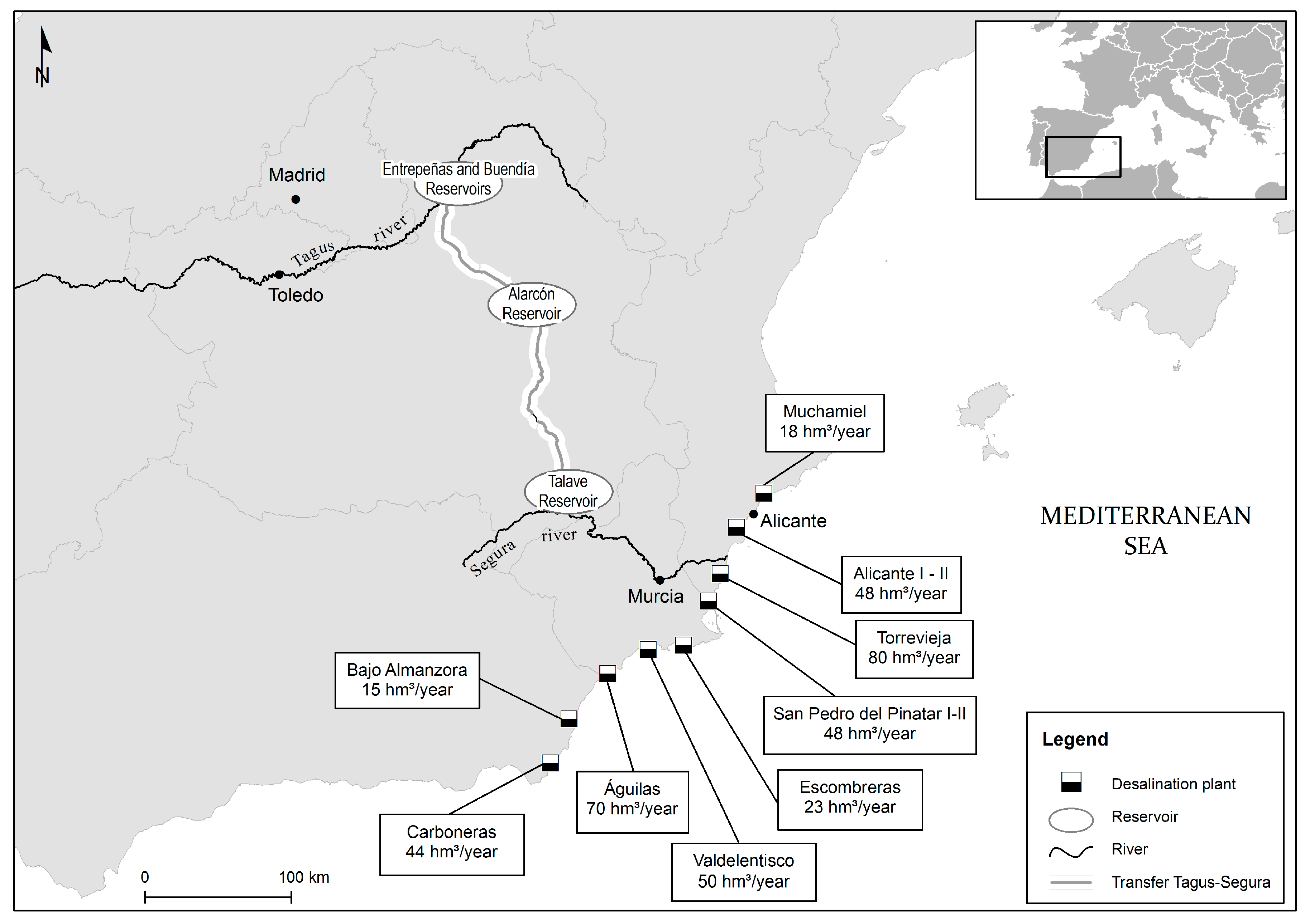
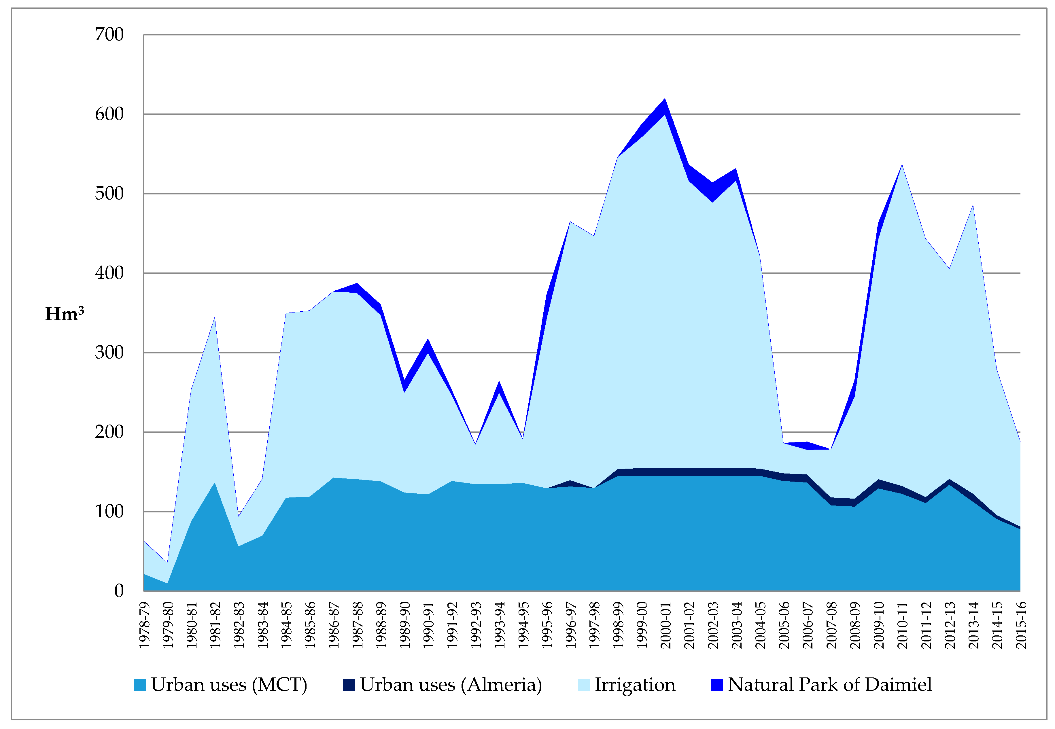
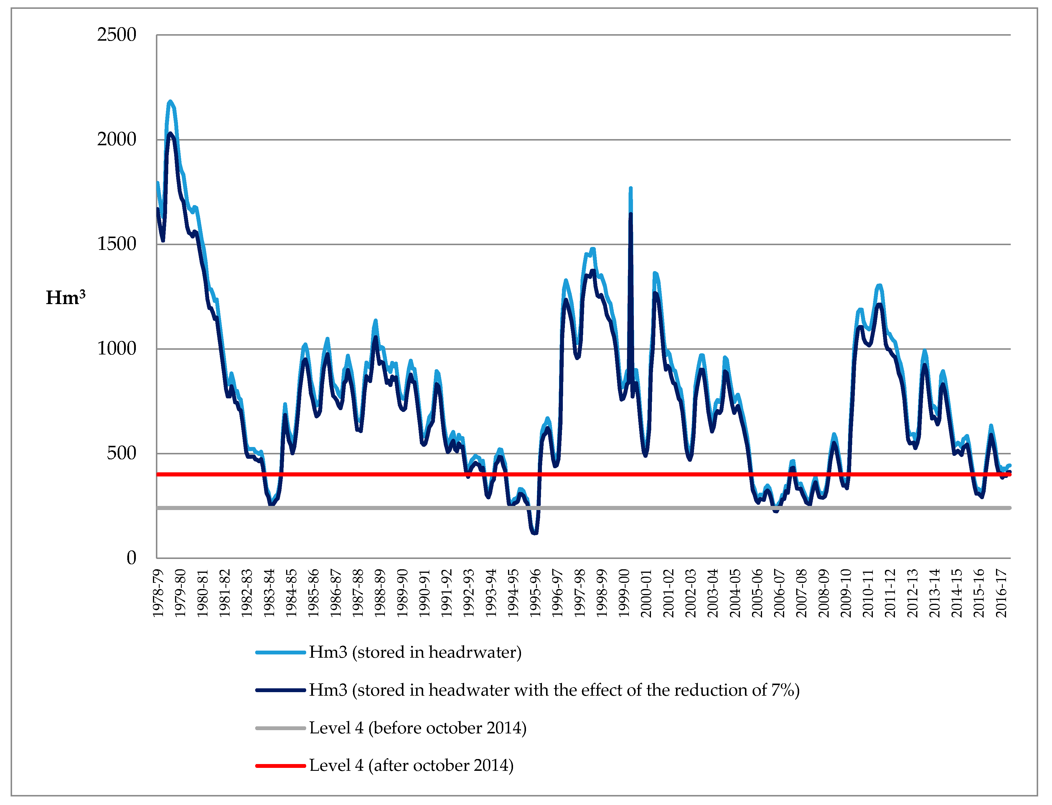
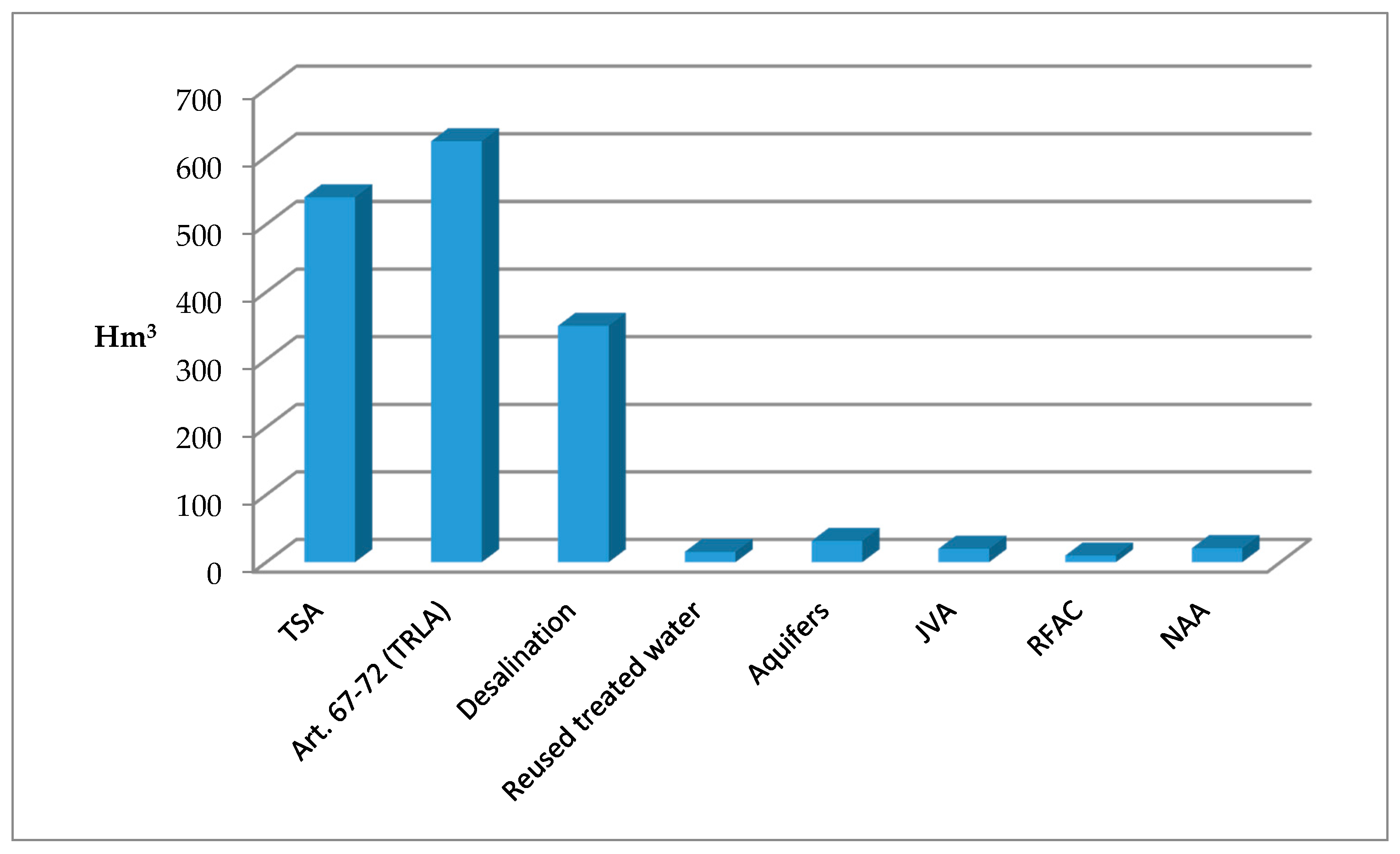
Table 1.
New management rules of the Tagus–Segura Aqueduct. Monthly flow levels stored in the headwater reservoirs (Entrepeñas and Buendía) and monthly transfer volume. Source: Law 21/2015, 20 July, which amends Law 43/2003, 21 November, in forestry.
Table 1.
New management rules of the Tagus–Segura Aqueduct. Monthly flow levels stored in the headwater reservoirs (Entrepeñas and Buendía) and monthly transfer volume. Source: Law 21/2015, 20 July, which amends Law 43/2003, 21 November, in forestry.
| Level 1 Volume Stored:
|
| Level 2 Volume Stored:
|
| Level 3 Volume Stored:
|
| Level 4 Volume Stored:
|
Table 2.
Basic features of water supply in the Tagus and Segura Rivers.
| Water Course | Basic Features of Rainwater Supply |
|---|---|
| Tagus |
|
| Segura |
|
Table 3.
Evolution of precipitation in the river basin districts of the Tagus and Segura, 2100 horizon. Source: Agencia Estatal de Meteorología (AEMET) [27]. Climate Projections for the 21st Century. (Statistical regionalization of analogues).
Table 3.
Evolution of precipitation in the river basin districts of the Tagus and Segura, 2100 horizon. Source: Agencia Estatal de Meteorología (AEMET) [27]. Climate Projections for the 21st Century. (Statistical regionalization of analogues).
| River Basin District | Precipitations (RCP 4.5) | Precipitations (RCP 8.5) | No. of Rainy Days (RCP 4.5) | No. of Rainy Days (RCP 8.5) | No. of Dry Days (RCP 4.5) | No. of Dry Days (RCP 8.5) |
|---|---|---|---|---|---|---|
| Tagus | −10% | −15% | −10 days | −20 days | +2.5 days | +5 days |
| Segura | −7% | −17% | −5 days | −10 days | +2.5 days | +5 days |
Table 4.
Evolution of temperatures in the river basin districts of the Tagus and Segura, with 2060 and 2100 horizons.
Table 4.
Evolution of temperatures in the river basin districts of the Tagus and Segura, with 2060 and 2100 horizons.
| River Basin District | Maximum Temperature (RCP 4.5) 2060 | Maximum Temperature (RCP 8.5) 2060 | Maximum Temperature (RCP 4.5) 2100 | Maximum Temperature (RCP 8.5) 2100 | % Increase No. of Warm Days * (RCP 4.5) 2100 | % Increase No. of Warm Days (RCP 8.5) 2100 |
|---|---|---|---|---|---|---|
| Tagus | +1.7 °C | +3 °C | +2 °C | +6 °C | 20% | 50% |
| Segura | +1.7 °C | +3 °C | +1.8 °C | +5 °C | 30% | 50% |
* No. of days with maximum temperature above the 90th percentile for the period of reference. Source: Agencia Estatal de Meteorología (AEMET) [27]. Climate Projections for the 21st Century. (Statistical regionalization of analogues).
Table 5.
Evolution of water resources and demands in the Tagus and Segura River Basin Districts, for the water planning horizons 2021 and 2033. Source: River Basin District Plans (2015–2021), Tagus and Segura.
Table 5.
Evolution of water resources and demands in the Tagus and Segura River Basin Districts, for the water planning horizons 2021 and 2033. Source: River Basin District Plans (2015–2021), Tagus and Segura.
| Resources (hm3/Year) (Series 1980–2012) | Demands (hm3/Year) | |||||
|---|---|---|---|---|---|---|
| 2015 | 2021 | 2033 | 2015 | 2021 | 2033 | |
| Tagus (Surface Resources) | 1653 (minimum) 6391 (mean) 15,214 (maximum) | 1537 1 (minimum) 5944 (mean) 14,149 (maximum) | 1537 (minimum) 5944 (mean) 14,149 (maximum) | 2800 | 2985 | 2984 |
| Segura (Total Resources) | 1280 --- 740 (natural flow Segura) 158 (desalination) | 1319 --- 740 (natural flow Segura) 193 (desalination) | 1332 --- 703 (natural flow Segura) 226 (desalination) | 1762 | 1731 | 1763 |
1 In the Tagus River Basin District, the reduction of resources has been applied as established in the HPI, which is that included in the River Basin District Plan.
Table 6.
Possible future scenarios and proposals to the Tagus–Segura Aqueduct (TSA).
| Scenarios | Proposals |
|---|---|
| Scenario 1. Design of emergency measures to confront drought years in which transfers cannot be made. Temporal closure of the TSA (Level 4: water stored in the headwater under 400 hm3) | Short-Term Actions |
| |
| Long-Term Actions | |
| |
| Environmental Impacts | |
| |
| Scenario 2. Reduction of supplies in the headwater due to the reduction of precipitation, increased intensity of drought episodes (climate change), and the increase of water demand in the donor basin | Short-Term Actions |
| |
| Long-Term Actions | |
| |
| Environmental Impacts | |
| |
| Scenario 3. Definitive closure of the Tagus–Segura Aqueduct (TSA) | Short-Term Actions |
| |
| Long-Term Actions | |
| |
| Environmental Impacts | |
| |
| In Any Scenario | Short-Term Actions |
| |
| Long-Term Actions | |
| |
| Environmental Impacts | |
|
© 2017 by the authors. Licensee MDPI, Basel, Switzerland. This article is an open access article distributed under the terms and conditions of the Creative Commons Attribution (CC BY) license (http://creativecommons.org/licenses/by/4.0/).
Share and Cite
MDPI and ACS Style
Morote, Á.-F.; Olcina, J.; Rico, A.-M. Challenges and Proposals for Socio-Ecological Sustainability of the Tagus–Segura Aqueduct (Spain) under Climate Change. Sustainability 2017, 9, 2058. https://doi.org/10.3390/su9112058
AMA Style
Morote Á-F, Olcina J, Rico A-M. Challenges and Proposals for Socio-Ecological Sustainability of the Tagus–Segura Aqueduct (Spain) under Climate Change. Sustainability. 2017; 9(11):2058. https://doi.org/10.3390/su9112058
Chicago/Turabian StyleMorote, Álvaro-Francisco, Jorge Olcina, and Antonio-Manuel Rico. 2017. "Challenges and Proposals for Socio-Ecological Sustainability of the Tagus–Segura Aqueduct (Spain) under Climate Change" Sustainability 9, no. 11: 2058. https://doi.org/10.3390/su9112058
Note that from the first issue of 2016, this journal uses article numbers instead of page numbers. See further details here.