1. Introduction
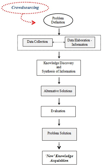
The focus of crowdsourcing is on knowledge acquisition for problem solving through the collection and synthesis of distributed knowledge. Knowledge acquisition involves an integrated process of raw data collection, data elaboration, information production and, finally, evaluation of the information produced. The above process may result in “new” knowledge generation, appropriate for planning purposes. On many occasions, the problem solving process involves the definition of a problem, but also the collection and elaboration of the most relevant data, in order to generate useful information. Sometimes, the process becomes very cumbersome, as specialized information and knowledge is required for problem solving, either at the stage of data collection or at the stage of setting alternative solutions. In such cases, crowdsourcing represents a robust option that facilitates the whole process.
Crowdsourcing has emerged out of the need to combine, in the problem solving process, existing knowledge from several scientific and professional fields, with the “wisdom of the crowd”. According to Surowiecki “under the right circumstances, groups are remarkably intelligent, and are often smarter than the smartest people among them” [
2]. The principal axiom of this approach is that no one knows everything; everyone has a specific expertise, and therefore, solutions can be reached by combining everybody’s knowledge and experience.
Crowdsourcing is a type of participatory process enabling collaborative knowledge to be collected and exploited when seeking for the most effective solution to a problem. Traditionally, knowledge diffusion and sharing can be achieved by organizing meetings where several aspects of the problem under study are discussed and alternative solutions are proposed. Such meetings were, until recently, based on the so-called “traditional” participatory methods and techniques, but the advent of computers and web-based technologies has created further capabilities for knowledge diffusion and exploitation. Based on this potential, Conroy and Gordon consider that “An interactive technology-based approach to public meetings provides a promising alternative” [
3].
During the last few decades, the remarkable progress that has taken place in the field of web technologies and the extended use of e-tools that strongly support crowdsourcing have created new opportunities for knowledge diffusion and problem solving in spatial planning. Several scientists and professionals, working in different fields, have adopted such technologies for the enrichment and facilitation of the decision process. As a result, modern decision support systems have integrated several tools and web services through which information generation and collaborative knowledge can be embodied in the decision making process.
The issues mentioned above are further clarified in the following paragraphs in which analytical details are presented, considering the functionality of crowdsourcing and its contribution to the problem solving process.
3. Crowdsourcing and GIS
As has already been mentioned in the previous sections, crowdsourcing is often adopted in order for a broad range of problems to be resolved. The present article mainly focuses on applications relating to geographic space, where crowdsourcing plays an important role in collecting or even generating geographic data from scratch. In such cases, it is usually integrated with GIS, facilitating the whole process of data collection and contributing thus to the creation of Integrated Public Participation GIS tools.
According to Goodchild, the implementation of several methods (in a geographic context) for data collection by distributed people exists, so that the information to be generated and diffused is so-called “volunteered geographic information” (VGI) [
11]. VGI is increasingly being used in the case of geographic applications, such as map generation or elaboration by several users, as a bottom-up process. In a decentralized system, data are produced “by the users for the users”. Therefore, one of the challenges of web 2.0 is to introduce intelligence into the way users can create, share and apply data by themselves [
12].
Crowdsourcing has been integrated with several web technologies (e.g., web GIS) and computer tools that offer the opportunity to create and manipulate data and information fast, as well as to diffuse knowledge. The creation and manipulation of spatial data (e.g., maps, geographic coordinates, satellite imagery) has nowadays become very popular among users of the web, who try to find places or routes on a map, analyze geographical data and, in many cases, create spatial data and publish them “for free” through the web. Crowdsourcing has essentially contributed to such kinds of applications as the users having the opportunity (in many cases, they are asked) to create geographical data from scratch, edit existing data, etc. Consequently, whole infrastructures have been created and are constantly evolving, allowing millions of users to have access to spatial data or to create and elaborate upon geographic content.
Such types of applications have been developed with the support of GIS, which allow the collection, storage, manipulation, distribution and reproduction of spatial data. Therefore, crowdsourcing has been integrated into other tools and is now a technique that can support spatial and collaborative planning, cartography and many other spatial applications, where the “wisdom of the crowd” is needed.
Interactive maps are usually adopted, as a means of visualization and communication, in cases where spatial problems have to be resolved. Participants in a crowdsourcing process interact with maps in order to add spatial content or represent a spatial problem or a proposed solution on a cartographic background. In some cases, participants are those who create maps and spatial data, so that such kinds of data can then be disposed through the web and be available to an extended number of users.
It is now clear that crowdsourcing in combination with GIS technology has set the basis for an alternative approach on spatial planning, where the process of spatial data generation (maps, etc.) takes place through the web, as volunteers contribute to the whole venture. At the same time, maps and spatial data can be exploited, for several purposes, by the participants of a problem solving process, so that the whole process is facilitated and enriched.
In the fifth part of the article, some cases in which crowdsourcing is combined with GIS are presented. Such cases concern real applications, which have been successfully developed through the integration of the above techniques, and also tools that have been built partially or totally “by the public for the public”.
4. Crowdsourcing Applications: From a General Framework to Spatial Planning Applications
The focus of this part is on the general framework, featuring several crowdsourcing applications, and also on the way the whole process “works”. Emphasis is given to the role that crowdsourcing can play in applications concerning spatial planning.
Crowdsourcing basically involves the definition of a problem, the publicizing of the respective problem or request as an “open call”, the recruitment of possible participants and the proposal of alternative solutions to the problem under study. The best solutions are awarded, and the company or the institution, which firstly published the problem, keeps and exploits the proposed alternatives.
Generally, crowdsourcing can be adopted by companies, institutions and universities in several ways, so that fast, efficient and innovative solutions are discovered. Commercial companies that sale retail, such as clothes, shoes
etc., request from the crowd to design products for them, and the most interesting designs receive a certain award. Several websites ask the crowd to upload products, such as photographs, and select the best among them in order to be uploaded on the site. Every download by the users of the site implies an award to the designer of the respective product. In the case of scientific institutions and universities, scientific problems are discussed and solutions are proposed by the users of the respective sites. As a result, innovative ideas and solutions arise, and organizations are offered the opportunity to discover skillful scientists from all over the world [
9].
It is now clear that the contribution of crowdsourcing to the problem solving process is undoubtedly essential, and this is the main reason for its wide acceptance, either as an autonomous module during the problem solving process or as part of a general methodology, in various scientific or professional fields.
Crowdsourcing enables the introduction of public participation, especially e-participation, into the planning process. In this context, a huge number of applications have been designed to serve several planning purposes and are implemented at both the urban and regional level. Some applications consider the issue of reaching consensus among stakeholders who are affected by the planning process, and thus, the purpose of such applications is stakeholders being involved in the process and expressing their opinions and preferences. Stakeholders can also discuss with each other, share content and knowledge, depict the opinions expressed on a map by the support of the respective web applications and propose and evaluate alternative solutions for the problem under study. In other words, they can “actively participate” and not simply get passively informed by the planners [
13].
In some other cases, citizens may participate even during the design stage of a platform through which a web community can be created. Such actions can take place at the level of a neighborhood, where citizens may act collectively towards a common end. In this way, citizens have the chance to meet each other, exchange the experiences of their daily life and discuss several issues relating to the problems of their neighborhood or city [
14].
As mentioned above, crowdsourcing is usually combined with GIS technologies, especially in cases where spatial information needs to be manipulated or generated. Recent advances referring to public participation GIS (PPGIS) applications include published maps relating to several environmental and spatial planning issues at the homepages of organizations, the implementation of real and dynamic GIS software that enables users to get in touch and interact with spatial information, Internet mapping for planning purposes, Internet-based public participation systems, information distribution and the citizens’ chance to build scenarios and suggest alternatives.
Some applications of this type relate to the shortest path problem. Shortest path algorithms are adopted in combination with information derived from the public, so that web applications relating, for example, to transportation issues are created. The public supports such a process by either providing content or by even participating in the designing phase of the application.
At this point, the essential role of maps as a means of communication among users and planners should be mentioned. Users are offered the opportunity to interact with web maps by depicting several problems detected in their neighborhood or in any other public area onto a map background, while on the other hand, planners can collect the information gathered from the maps in order to further exploit it during the planning process [
15]. In many cases, users may also represent a possible solution of a specific problem on the map.
Another approach, concerning citizens’ participation in the decision making process, is that of spatial planning games. From such a perspective, citizens are involved in a creative and interesting process, which helps them to be more familiarized with the whole planning process. There are some web applications performed under such an approach, which are very popular with the public, as prior knowledge of “how to use” each specific application is not necessary [
16].
Hitherto, it has been clear that crowdsourcing can be adopted in several cases in order for effective solutions to be reached by exploiting the knowledge and experience of the public. Such an approach reinforces democratic processes and transparency in the planning process.
5. Examples of Crowdsourcing Applications in Spatial Planning
The focus of this part is on some specific crowdsourcing applications concerning spatial planning and also on the tools adopted in each of them. The case studies below mainly focus on the issue of knowledge acquisition through the implementation of crowdsourcing techniques in spatial planning problems where the involvement of the crowd plays a crucial role in making plans and decisions. “Strong plans accompanied by broad stakeholder involvement are needed if plans are to have a significant effect on the actions of local governments” [
17]. In the following cases, crowdsourcing is adopted for the collection and manipulation of spatial data, but also for the generation and analysis of spatial information.
In the case of the “Potenza project” (Italy), a “kit of e-participation with free web-ware tools” was developed by the “Laboratory of Urban and Territorial Systems” (University of Basilicata), which combines social, sharing, mapping and decision tools. The aim of this project was the development of a participatory tool enabling the reaching of consensus among stakeholders on several proposed alternative solutions to a planning problem and the acquisition of valuable feedback from the crowd, by combining traditional and electronic approaches. Under this rationale, social network tools and the potentiality of web communities were exploited. Participants in such a process were the coordinators of the Urban Labs, citizens who participated in workshops and also citizens who were interested in the workshops [
18]. Sharing tools like “Box” (an online file sharing tool), “YouTube” (a video sharing tool), “Vimeo” (a video sharing tool), “Flickr” (an online photo management and sharing tool) and “Slideshare” (an online presentations sharing tool) make the process more transparent and were adopted with the purpose of sharing information, like documents, images, slides and multimedia. Among the available mapping tools, Google Earth and Google Maps have been chosen for the scope of this application. By using Google Earth, users can create, represent and exchange spatial information. They can also depict GEO-SWOT analysis results, built during workshops, on Google Maps by creating mashups—“citizens have created some mashups, linking information, photos and comments to a specific location” [
18]. Finally, decision tools have been incorporated to the “kit” in order to help users express their preferences through surveys or an electronic vote. Such an example is “Google Docs”, which helps the design of a survey and the storage of collected data in a spreadsheet. At this point, it should be mentioned that such a kind of survey may also help the online evaluation of several projects.
Some applications consider citizens’ participation at the design stage of a platform through which a web community can be created. The tools needed for the design of web-based online communities, existing in virtual space, are a communication network and also software that defines the user interface. In this way, wireless network communities can be established at the neighborhood level, where citizens discuss several problems and promote solutions. An example of such a kind of neighborhood community is the eco-villages (eco-village Vancouver, Phinney eco-village Seattle), whose main interest is to strengthen the community’s vitality around healthier lifestyles and ecological aspirations [
14]. Another creative web community has been established in Isola (Milan), a collective action called “Cantieri Isola”, where neighbors have the opportunity to share proposals and ideas, acquire and exchange knowledge, anticipate and manage changes in their neighborhood and also attract a diversity of people and services in the neighborhood [
14]. The main purpose of the Isola community—“Cantieri Isola” action—is to compensate for the absence of an institutional organization at the neighborhood level by adopting and exploiting the idea of neighborhood networking [
14]. In Los Angeles, citizens participate in neighborhood councils through wireless neighborhood communities by expressing opinions and proposals on several projects concerning their area, independently of their social or economic situation. Wireless neighborhood communities (WNC) constitute a novel way of initiating, stimulating and maintaining collective actions at the neighborhood level [
14].
Regarding the issue of “map creation”, users of the web can contribute to the creation of online maps and relative geographic information. Google Maps is an example of web mapping where users can enrich the content of base maps by adding spatial or attribute data or information. OpenStreetMap (OSM) is another example of user created map content, which is broader compared to other alternatives, such as WikiMapia, which is based on Google Maps [
12]. “Citizens participating in OSM became more sensitive to the surrounding world, to their representation in computers and also more aware to changes in their neighborhood” [
19]. As a result, citizens are gradually becoming more familiar with tools used for manipulating spatial information with the support of a “web editor”. This is a kind of GIS software requiring no installation or license. Every user can take part and add elements on a map background or even create the map.
“MapTube” is also an application that allows users to overlay shared maps and compare data visually. The map creation process has been combined with responses given by people after invitations from a radio station. Each user-response updates the respective element of a database of the underlying shape file with GMapCreator running every 30 minutes. A new map is created, and subsequently, “MapTube” is updated. “This is Neogeography: free, easy to use and yet potentially very powerful in terms of GI science, social science and the ability of both professionals and amateurs to tap into the expertise of users and
vice versa” [
12].
A project implemented in Portugal concerned the mapping of McDonald’s restaurants. McDonald’s webpage was used for the necessary information about the McDonald’s restaurant distribution to be extracted with parsing techniques. The information was then compared to the existing restaurants in OSM maps, and the user’s task was to map (by editing the OSM map) the missing restaurants or correct the distance between two restaurants. An issue emerged in this context, which had to do with the tracking of changes and the updating of the map. In this case, two approaches were adopted: the first concerned the periodical visiting of the source website for checking to see if any changes exist, while the second concerned the checking of the features’ date and time of last editing [
19].
The “Woodberry Down Project” is another application created for the regeneration of Woodberry Down Estate in the London borough of Hackney, one of the most deprived boroughs of London. It mainly concerns the design of an online system that will support the area’s future development. In this context, an authority’s website has been created, which delivers everything, from routine services to ideas (alternative options) for the area’s future [
13]. The application enables text and maps to be displayed, data to be downloaded and users to provide feedback indirectly through e-mail or directly through modified bulletin boards [
13]. The purpose of this application was to enable local communities to learn more about their local environment and participate (community participation) in the development of ideas for making Hackney a more livable place [
13]. Towards this end, some kinds of “educational software” (site) have been developed, based on GIS and digital panoramas, which facilitate the participation of the residents and the study of the local community. The site contains textual information relating to the area’s regeneration, mappable information (maps and panoramas), so that the residents can “see” the future view of their area, a bulletin board that enables citizens to post comments and also a 3D view of the area’s possible future. That last ability will further be extended by allowing citizens to upload their own designs and schemes [
13].
In cases where crowdsourcing is combined with GIS, there are several interfaces that support the input of points, lines, polygons, as well as users’ comments. Moreover, PPGIS, in combination with multi-media technologies, enables users to share spatial information by using videos (audio-visual information) and “changes over time” (play-back) or proposals for the future of a specific area. Internet GIS may improve the democratic foundations of the participatory process, while PPGIS consists of an effective means for increasing community participation in the evaluation process [
20].
A simple PPGIS application has been developed in the case of Slaithwaite (U.K.), based on the “Planning for Real” (PFR) participatory model. The original idea for such a model was developed and patented by the Neighborhood Initiatives Foundation (NIF) as a means of involving people more closely in local environmental planning problems and decision making [
21]. In the case of Slaithwaite in West Yorkshire, the PFR model was adopted so that the “Virtual Slaithwaite”, an effective web-based mapping application implementing the online model of the village (online PPGIS facility), was created under the “Slaithwaite PFR” or “Shaping Slaithwaite” exercise. The exercise focused on the construction of a three-dimensional model of a 2 km-square area of Slaithwaite and the surrounding valley, which supported the discussion on several planning issues (e.g., plans to re-open the canal through the center of the village, access to industrial sites,
etc.) [
21]. Residents were invited to express their opinion, thus giving feedback, so that the whole exercise was supported by the participation of the crowd. More specifically, the application allows the local community to interact with a digital map (mappable information), which gives relatively instant access to the queries they pose [
21]. Users can access any point or areas of the village by clicking on it, ask questions for further details concerning the spatial entities depicted on the map layer (e.g., buildings) and post comments concerning the future development of specific locations [
21]. The user input is stored and used for future analysis during the planning process. Thus, a community database is created representing a range of views about planning issues in the village. The tools adopted for the construction of such an application include: a Java map application, called GeoTools, which allows the user to perform a simple spatial query and attribute input operations, thus enabling the interaction between the user and the map. The user responses were handled using Perl server-side scripts and HTML (HyperText Markup Language) forms. Finally, the map applet used displays a set of ESRI Arcview shape files allowing pan and zoom operations and the retrieval of attribute information from the associated .dbf file [
21].
Another PPGIS application has been developed in Australia by “Parks Victoria” (the national park management agency for Victoria) and the Parks Victoria Alpine Planning team for national park planning. The study region is the Greater Alpine National Parks, which contain five smaller national parks, wildlife regions and three regions of historical interest [
15]. The expected input to this specific system involves citizens’ points of view (represented as markers on a map), derived from their personal experience about the park, as well as information relating to the environmental effects in the park and the facilities and services offered in the different zones of the park. Such kinds of information are marked with the support of a cartographic internet-based platform, and then, they are imported into a decision support system for national park planning in order to be further analyzed. In some cases, indexes were determined expressing the quality of the variables per park land unit, as well as index thresholds, which were further elaborated by statistical analysis. The main objectives of the project focus on the collection of information from the public (experiences, environmental effects, comments about the offered facilities and services) and the exploitation of this information for redesigning and upgrading the park region in order to cope with climate change, fire risk and grazing. Enforcing alternative tourism activities is also an important objective of the study [
15]. The data were collected and further analyzed with the adoption of GIS and web-GIS technology. A PPGIS website was created through which respondents could interact with the map of the park by placing markers that correspond to several variables of the park and also by optionally annotating each marker location with text [
15]. Thus, data and knowledge from the public were collected using an interactive spatial component (web map) and also an online questionnaire. In parallel, the views of the public were compared to the views of the park staff. The system (PPGIS Mapping for National Park Planning) supports the following operations: inputting data collection from the visitors and the public, analyses carried out by the planners and managers of the park (output) and the generation of a report that contains a descriptive analysis, an inferential and managerial analysis, maps of the density/hot spots of the park (created with ArcGIS software), radar charting and tables [
15].
The whole process is integrated through the following steps:
Collection of data for park variables;
Development of a webpage containing the map of the park;
Representation of each variable as a marker that the user can place onto the map (drag and drop); each marker can be accompanied by a user’s comment;
Completion of a questionnaire by the user concerning personal information and issues related to the park;
Promotion of the system via e-mails.
The collected data are further analyzed, and useful information is produced that may support the decision making process. Based on these data, the setting of priorities for the regions and services where scarce managerial resources should be allocated is carried out. The quality thresholds are specified and the experiences/environmental effects and the level of the offered services presented, and also, proposals for redesigning and upgrading the park for management are described [
15].
Another interesting application was developed at the University of Delft, with the support of several computing tools known as “obstacle avoidance” tools. The goal of the application is the computation of a network of alternative “shortest paths” in a city, in case of an emergency state, such as an earthquake, where obstacles existing on the road network block the traffic and hamper the access of the rescue services in several parts of the city. The tools adopted for the development of this application are Google Maps and the respective application, Directions Service (Google servers), for searching the shortest route by exploiting the A* algorithm. The possible obstacles, existing on the road network, are represented as polygons on the map through a process of gaining feedback from the crowd (the users of the infrastructure), who send the respective information by using their smartphones, personals computers,
etc. The whole concept of the application is based on the process of collection, analysis, dispatch and diffusion of spatial data to the users and the rescue services. In this context, a platform was created that enables the receipt of “crowdsourced” information concerning the infrastructure condition and the existing obstacles. The information is derived from the users of the infrastructure and exploited by rescue services in order for the latter to be informed of the obstacles and seek alternative routes [
22]. Users send the information through their devices, which are provided with the Google Maps’ API tool.
Another approach of public participation and “crowdsourced” knowledge acquisition for planning purposes via the web is the “playful public participation” approach. The goal of such an approach focuses on the adoption of the “playful public participation” concept and the potential use of games and “play” during the public participatory planning process. Games are used as a stimulating computer-based tool that can potentially involve citizens in serious public participatory processes [
16]. Some examples of such kinds of projects are presented below [
16]:
SimCity”: This is a city management game, delivering a true multi-city scale, where users can control a region. The goal of the game is to create “ideal cities”. It was originally designed by Will Wright and published by Maxis (division of Electronic Arts). It was developed inCalifornia, and its characteristics are mainly based on California’s image and development in the 20th century [
23]. The user can “build” a city, define several zones (industrial, residential,
etc.), make proposals about the investments, the taxes, the control of flooding,
etc.PlastiCity”: This is a “multiplayer urban planning game”. The goal of the game is for the players to reshape the Bradford (U.K.) city center. This project started in 2004. It encapsulates the architectural ideas of Will Alsop. It was conceived of by the author, Steve Manthorp, built by Mathias Fuchs and Vera Schlusmans (programming) and Umran Ali and Kelvin Ward (modeling) [
24].
Urban Plans”: This is a video game similar to “SimCity”. The urban environment (buildings, trees, universities, etc.) can be located by the user everywhere in the city. The user, who has a pre-defined budget for shaping the city, tries to manage the urban environment. It is available online through the site “Maniac World”.
City Creator”: The goal of this game is to create a city. It is similar to “Urban Plans”, but the elements of the city are not labeled as in “Urban Plans”; instead, their function should be determined by the user’s perception of the icon. “City Creator” is a joint project by Denise Wilton and Carl Henderson. Wilton came up with the original idea and design, and Henderson helped the idea along and made it all come to operation by programming it [
25].
Computer game environments have been experimentally utilized in an effort to investigate their possible contribution to public participation planning exercises. Such kinds of games can be created for any city and be exploited for “playful public participation” purposes in order to gain feedback from the crowd.
“Marmo Platano-Melandro” is another case where a PPGIS application was created in the framework of the “Marmo Platano-Melandro Territorial Integrated Projects”, which took place from 2006–2009, in the area of Marmo Platano-Melandro (Italy). The purpose of these projects was the development of synergies and scale economies in a multi-scalar perspective of governance favoring groups of municipalities [
26]. The projects were supported by the Laboratory of Urban and Territorial Systems (University of Basilicata), the European Union and the Department of Agriculture, Rural Development and Rural Economy of the Basilicata prefecture. In this application, a website (WEBSITE), containing information on the project and the area, was created, while a web-GIS application (WEBGIS), offering access to geographic information, was implemented on an open-source platform. These tools were combined with a typical blog (BLOG), which provides interaction capabilities in order to acquire feedback from citizens, concerning planning actions, while simultaneously giving them the chance to participate in the different stages of several actions [
26]. A web map service (WMS) was also developed, through which it is possible to reproduce maps dynamically in JPEG, GIF or PNG format in any GIS software. Many activities had been located on maps with the support of municipality staff, while others were identified by means of Google Earth. They were represented on the map as points, lines and polygons. As for the blog, it enriches participation and interaction among citizens and institutions responsible for defining policies. BLOGs’ purposes can be summarized in the following points [
26]:
Active participation of users through comments;
Collection of all instances concerning past and future planning policies;
Establishment of dialogue between organizations and data users;
Constant involvement of citizens in public decisions and enrichment of collaboration;
Transparency and accessibility to the decision making processes;
Transparency in intervention programming.
For the city of Fredericton, New Brunswick, Canada, a GIS-enabled discussion forum (GeoDF) has been implemented, as a means through which the government can gain feedback from the public on several spatially related issues, by exploiting web-mapping and analysis tools.
The characteristics of the system are the following [
27]:
It enables citizens to provide more in-depth feedback to the government, through the use of enhanced, easy-to-use, web-based mapping and analysis tools;
It allows participants to submit and share feedback, as well as to initiate discussions about their concerns, either by writing text messages or by making sketches and annotations on a GIS map;
It “conveys” a participant’s perspective, as the map extent and the map layers that one is viewing are stored by the system and shared among all the participants.
The system is a web-based application that introduces the spatial context to an online discussion forum with the support of a web-based GIS and a spatial database. ArcIMS has been selected as the spatial server, and the online discussion forum is based on the open source bulletin board software, phpBB. The graphic tools used are the Javascript sketching tool and several annotation tools. The map layers are file-based, while data from the discussion forum are stored in a MySQL database with spatial extensions [
27]. The webpage (user’s interface) contains a WebGIS map viewer and a forum menu designed as a tree structure for organizing discussion contributions by issues in reverse chronological order. Depending on the discussing issue, the user can simultaneously choose the suitable graphic representation. With the “Show areas of hottest discussion” command, citizens can view at a glance which areas attract the most discussion contributions. With the “comments tool”, the user can retrieve contributions based on locations by dragging a box over a certain area and selecting which contribution to display on the map.
The case studies presented above concern mainly spatial applications related to spatial planning and the management of spatial problems. In such cases, “e-tools” support the problem solving process and decision making by facilitating data collection and solution formulation through the exploitation of web technologies and crowdsourcing techniques. Crowdsourcing plays a crucial role in the whole process, as it allows for the broad publication of a spatial problem and the extensive participation of the crowd so that spatial and attribute data is created or a solution to the problem under study is explored. In this context, GIS offers an outstanding contribution, as it supports the management of spatial information and the representation of spatial data on a map background. In addition, the adoption of crowdsourcing techniques in spatial planning is of exceptional importance, as it enhances public participation and also enriches the feedback that can be gained in planning exercises. The combination of crowdsourcing and GIS sets the base for the establishment of more successful and effective planning solutions.
The above applications are indicative of the efforts taking place in order for “crowdsourced” information to be produced for planning purposes. All of them adopt the rationale of collecting and exploiting knowledge emanating from the public, thus involving a potential number of participants in the respective planning exercises. GIS enforces the whole process by allowing the visualization of spatial problems and proposed solutions, as well as the establishment of discussions among participants “onto” a map background. Although the participation of the crowd may sometimes be limited, such efforts are particularly remarkable, as they set the base for further development of similar applications and also promote the advantages of crowdsourcing adoption in the planning process. Moreover, through these efforts, deeper research and further progress towards the adoption of such approaches and techniques by planners and “geo-scientists” are encouraged.
Crowdsourcing offers planners the possibility to communicate with a huge number of potential participants, choose the most suitable solution among various available solutions “produced” by the crowd and also gain remarkable feedback that supports the whole planning process. It also enhances the transparency and the pluralistic character of the process, but its most important contribution is basically the potential of acquiring knowledge, exploiting the “wisdom of the crowd” for planning purposes and synthesizing it so that better solutions can be discovered and “new” knowledge produced.


