Understanding Measurement Reporting and Verification Systems for REDD+ as an Investment for Generating Carbon Benefits


Abstract
:1. Introduction
- historical rates of deforestation, degradation and emission factors, also using adjustment factors to allow inclusion of social and economic variables (named “national circumstances”) [13], and
1.1. State of the Art
1.1.1. Model-Assisted Design-Based AGB Estimation Using Remote Sensing
1.1.2. Cost-Efficiency of Lidar-Based Methods
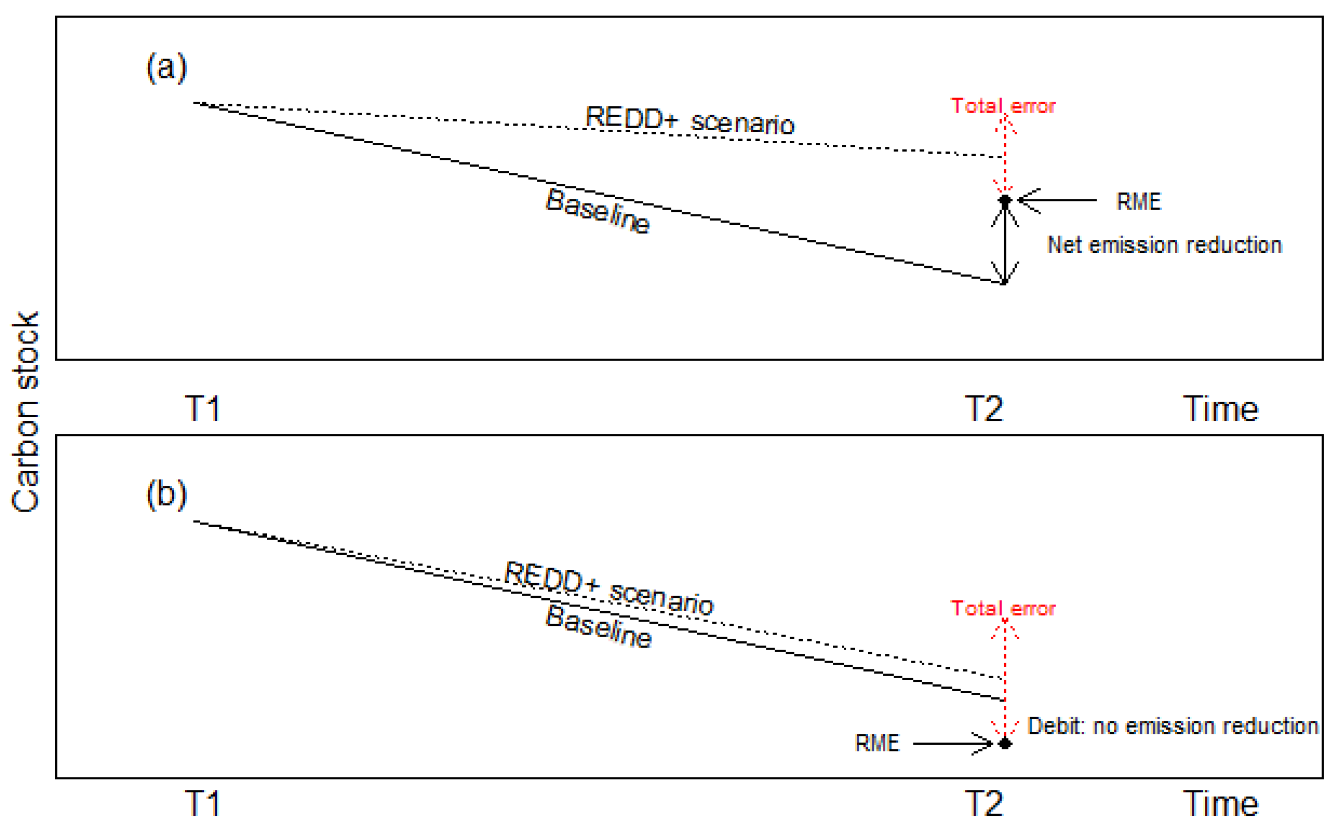
1.1.3. Addressing Uncertainties in REDD+: the Reliable Minimum Estimate
2. Materials and Methods
2.1. Data Used
2.1.1. Field Data
2.1.2. Lidar Data Extraction
2.1.3. Cost of Carbon Monitoring
2.2. Simulation Approach
- (1)
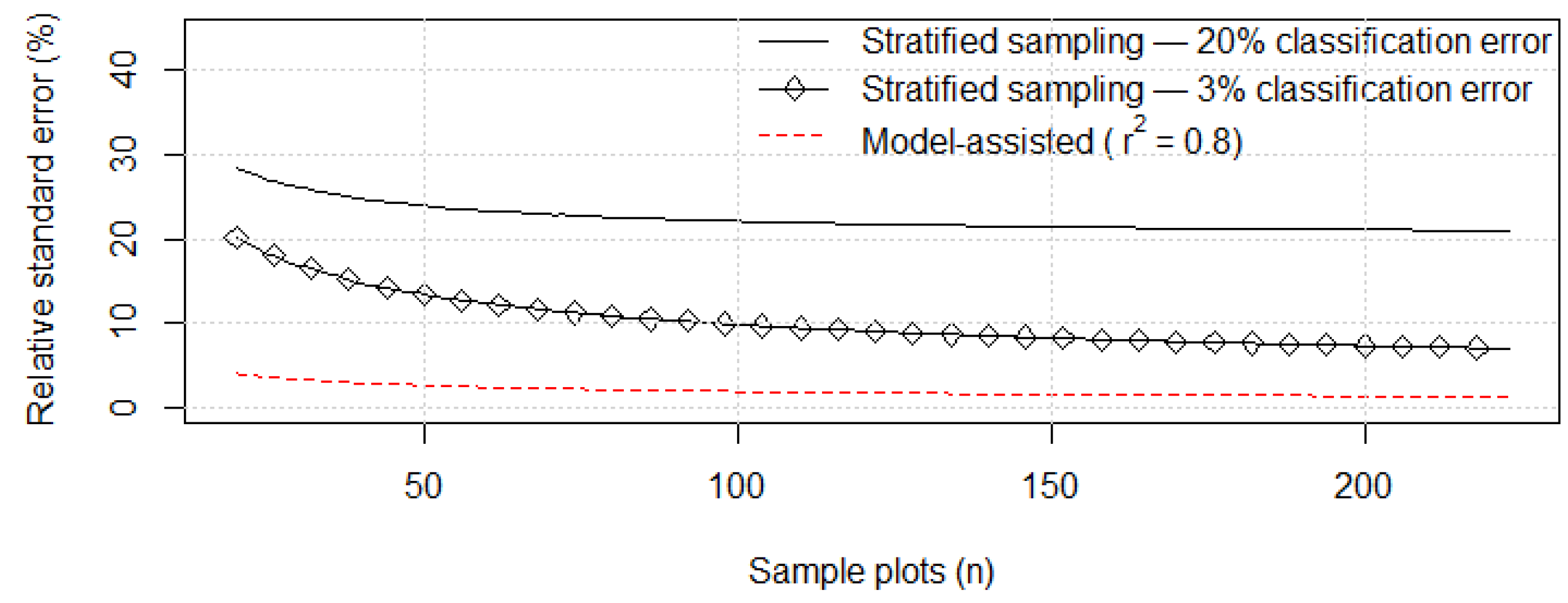
- We created a series of subsamples from the 223 plots via bootstrapping. We simulated sampling with replacement for each sample size with 1000 iterations, starting from a sample size of 20 plots and increasing the size by one unit at a time, up to 223 plots. This resulted in a total of 204 different sample sizes and 204,000 iterations. Subsequently, the variance and the relative standard error of the estimate of aboveground carbon density (i.e., in Equation (1)) were calculated for each iteration. Finally, the relationship between the relative standard error and the number of field plots was assessed.
- (2)
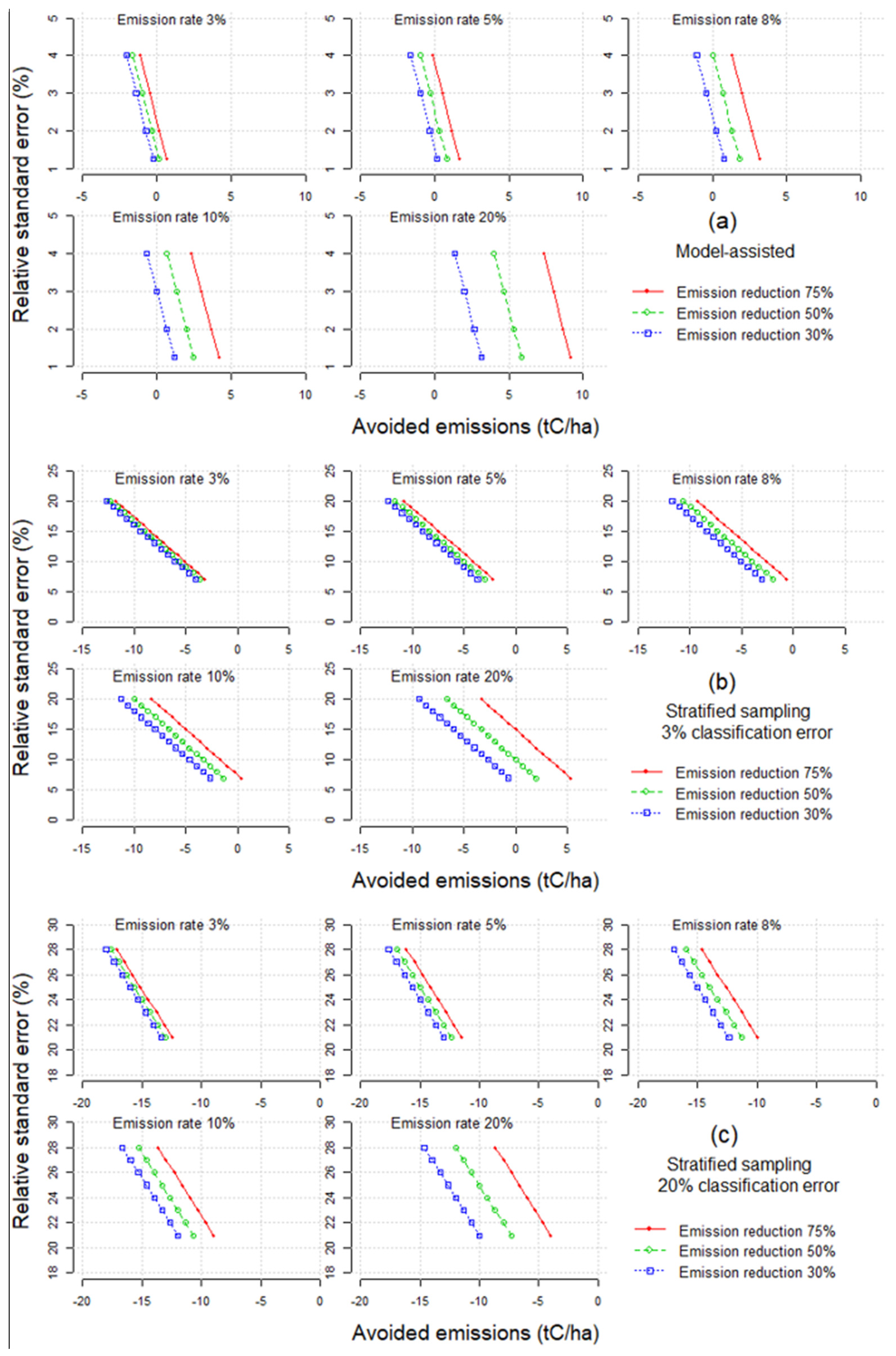
- We investigated, by a scenario approach, how uncertainties expressed by the relative standard error obtained in step 1 determine the accountable avoided emissions. Each scenario is characterized by a different combination of (i) the accuracy of carbon monitoring (expressed by the relative standard error), (ii) the baseline carbon emissions from deforestation and forest degradation (i.e., RLs), and (iii) target for emission reductions as a result of REDD+ activities. The errors associated with the estimation of carbon stock changes were linked to the potential generation of carbon credits. Table 3 presents details of the scenarios implemented.
- (3)
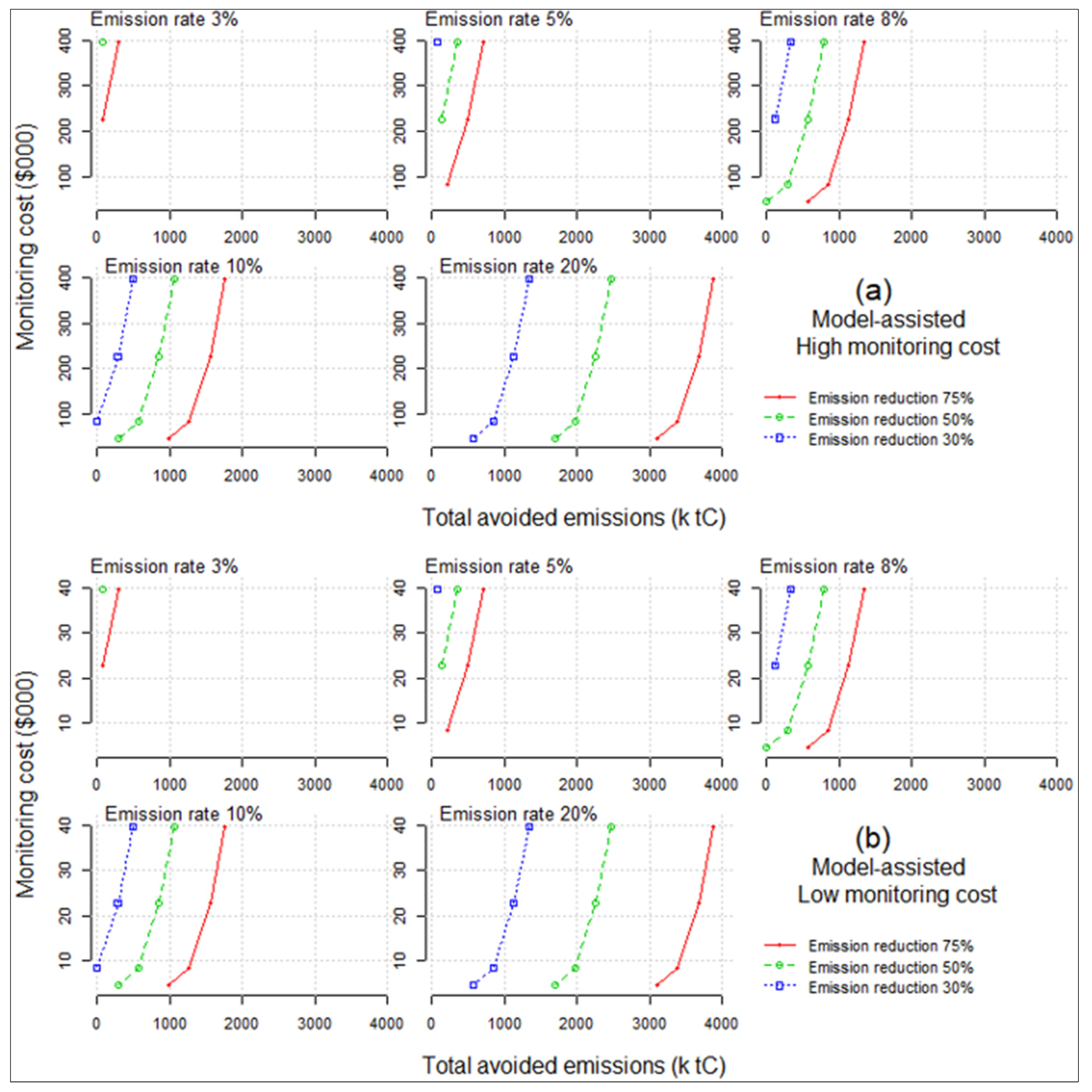
- Finally, the results of steps 1 and 2 were combined with a set of realistic monitoring costs. For the alternative monitoring systems, as presented in step 2, different levels of uncertainty and cost frameworks were realized and the achievable amounts of accountable avoided emissions calculated. This allows to study the cost-efficiency of alternative MRV-designs.
2.3. Sensitivity Analysis
3. Results
4. Discussion
5. Conclusions
Supplementary Materials
Acknowledgments
Author Contributions
Conflicts of Interest
References
- Stern, N. the Price of Change. IAEA Bull. 2006, 48, 25. [Google Scholar]
- Center for International Forestry Research. Realising. REDD+ National Strategy and Policy Options; Angelsen, A., Brockhaus, M., Center for International Forestry Research, Eds.; Center for International Forestry Research: Bogor, Indonesia, 2009; ISBN 978-602-8693-03-5. [Google Scholar]
- Plugge, D.; Baldauf, T.; Köhl, M. The global climate change mitigation strategy REDD: monitoring costs and uncertainties jeopardize economic benefits. Clim. Chang. 2013, 119, 247–259. [Google Scholar] [CrossRef]
- Part two: Action taken by the Conference of the Parties at its nineteenth session. Proceedings of United Nations Framework Convention on Climate Change Report of the Conference of the Parties on its nineteenth session, Warsaw, Poland, 11–23 November 2013; United Nations Office: Geneva, Switzerland, 2014.
- Tomppo, E.; Olsson, H.; Ståhl, G.; Nilsson, M.; Hagner, O.; Katila, M. Combining national forest inventory field plots and remote sensing data for forest databases. Remote. Sens. Environ. 2008, 112, 1982–1999. [Google Scholar] [CrossRef]
- Melville, G.; Stone, C.; Turner, R. Application of LiDAR data to maximise the efficiency of inventory plots in softwood plantations. N. Z. J. For. Sci. 2015, 45. [Google Scholar] [CrossRef]
- Romijn, E.; Lantican, C.B.; Herold, M.; Lindquist, E.; Ochieng, R.; Wijaya, A.; Murdiyarso, D.; Verchot, L. Assessing change in national forest monitoring capacities of 99 tropical countries. For. Ecol. Manag. 2015, 352, 109–123. [Google Scholar] [CrossRef]
- Neeff, T.; Somogyi, Z.; Schultheis, C.; Mertens, E.; Rock, J.; Brötz, J.; Dunger, K.; Oehmichen, K.; Federici, S. Assessing progress in MRV capacity development: experience with a scorecard approach. Clim. Policy 2015, 1–10. [Google Scholar] [CrossRef]
- Angelsen, A. REDD+: What should come next? In Towards a Workable and Effective Climate Regime; CEPR Press: London, UK, 2015; pp. 405–421. ISBN 978-1-907142-95-6. [Google Scholar]
- Köhl, M.; Lister, A.; Scott, C.T.; Baldauf, T.; Plugge, D. Implications of sampling design and sample size for national carbon accounting systems. Carbon Balance Manag. 2011, 6, 1–20. [Google Scholar] [CrossRef] [PubMed]
- Rantala, S.; Hajjar, R.; Skutsch, M. Multilevel Governance for Forests and Climate Change: Learning from Southern Mexico. Forests 2014, 5, 3147–3168. [Google Scholar] [CrossRef]
- Bayrak, M.; Marafa, L. Ten Years of REDD+: A Critical Review of the Impact of REDD+ on Forest-Dependent Communities. Sustainability 2016, 8, 620. [Google Scholar] [CrossRef]
- Mollicone, D.; Achard, F.; Federici, S.; Eva, H.D.; Grassi, G.; Belward, A.; Raes, F.; Seufert, G.; Stibig, H.-J.; Matteucci, G.; et al. An incentive mechanism for reducing emissions from conversion of intact and non-intact forests. Clim. Chang. 2007, 83, 477–493. [Google Scholar] [CrossRef]
- Kamusoko, C.; Oono, K.; Nakazawa, A.; Wada, Y.; Nakada, R.; Hosokawa, T.; Tomimura, S.; Furuya, T.; Iwata, A.; Moriike, H.; et al. Spatial Simulation Modelling of Future Forest Cover Change Scenarios in Luangprabang Province, Lao PDR. Forests 2011, 2, 707–729. [Google Scholar] [CrossRef]
- Di Lallo, G.; Mundhenk, P.; Zamora López, S.; Marchetti, M.; Köhl, M. REDD+: Quick Assessment of Deforestation Risk Based on Available Data. Forests 2017, 8, 29. [Google Scholar] [CrossRef]
- Griscom, B.; Shoch, D.; Stanley, B.; Cortez, R.; Virgilio, N. Sensitivity of amounts and distribution of tropical forest carbon credits depending on baseline rules. Environ. Sci. Policy 2009, 12, 897–911. [Google Scholar] [CrossRef]
- Huettner, M.; Leemans, R.; Kok, K.; Ebeling, J. A comparison of baseline methodologies for “Reducing Emissions from Deforestation and Degradation”. Carbon Balance Manag. 2009, 4, 4. [Google Scholar] [CrossRef] [PubMed]
- Goetz, S.J.; Baccini, A.; Laporte, N.T.; Johns, T.; Walker, W.; Kellndorfer, J.; Houghton, R.A.; Sun, M. Mapping and monitoring carbon stocks with satellite observations: a comparison of methods. Carbon Balance Manag. 2009, 4, 2. [Google Scholar] [CrossRef] [PubMed]
- Särndal, C.-E.; Swensson, B.; Wretman, J. Model Assisted Survey Sampling; Springer Series in Statistics; Springer-Verlag: New York, NY, USA, 1992; ISBN 978-0-387-40620-6. [Google Scholar]
- Asner, G.P.; Knapp, D.E.; Martin, R.E.; Tupayachi, R.; Anderson, C.B.; Mascaro, J.; Sinca, F.; Chadwick, K.D.; Higgins, M.; Farfan, W.; et al. Targeted carbon conservation at national scales with high-resolution monitoring. Proc. Natl. Acad. Sci. USA 2014, 111, E5016–E5022. [Google Scholar] [CrossRef] [PubMed]
- Zolkos, S.G.; Goetz, S.J.; Dubayah, R. A meta-analysis of terrestrial aboveground biomass estimation using lidar remote sensing. Remote. Sens. Environ. 2013, 128, 289–298. [Google Scholar] [CrossRef]
- Sinha, S.; Jeganathan, C.; Sharma, L.K.; Nathawat, M.S. A review of radar remote sensing for biomass estimation. Int. J. Environ. Sci. Technol. 2015, 12, 1779–1792. [Google Scholar] [CrossRef]
- Baldauf, T.; Galo, A.J.J. Fundamentals and Applications of Remote Sensing in Tropical Forestry. In Tropical Forestry Handbook; Pancel, L., Köhl, M., Eds.; Springer: Berlin/Heidelberg, Germany, 2015; pp. 1–20. ISBN 978-3-642-41554-8. [Google Scholar]
- Tokola, T. Remote Sensing Concepts and Their Applicability in REDD+ Monitoring. Curr. For. Rep. 2015, 1, 252–260. [Google Scholar] [CrossRef]
- Saarela, S.; Grafström, A.; Ståhl, G.; Kangas, A.; Holopainen, M.; Tuominen, S.; Nordkvist, K.; Hyyppä, J. Model-assisted estimation of growing stock volume using different combinations of LiDAR and Landsat data as auxiliary information. Remote. Sens. Environ. 2015, 158, 431–440. [Google Scholar] [CrossRef]
- Hansen, E.; Gobakken, T.; Solberg, S.; Kangas, A.; Ene, L.; Mauya, E.; Næsset, E. Relative Efficiency of ALS and InSAR for Biomass Estimation in a Tanzanian Rainforest. Remote. Sens. 2015, 7, 9865–9885. [Google Scholar] [CrossRef] [Green Version]
- IPCC. Good Practice Guidance for Land Use, Land-Use Change and Forestry; Penman, J., Gytarsky, M., Hiraishi, T., Krug, T., Kruger, D., Pipatti, R., Buendia, L., Miwa, K., Ngara, T., Tanabe, K., et al., Eds.; The Intergovernmental Panel on Climate Change: Hayama, Kanagawa, Japan, 2003; ISBN 978-4-88788-003-0. [Google Scholar]
- Grassi, G.; Monni, S.; Federici, S.; Achard, F.; Mollicone, D. Applying the conservativeness principle to REDD to deal with the uncertainties of the estimates. Environ. Res. Lett. 2008, 3, 035005. [Google Scholar] [CrossRef]
- Köhl, M.; Baldauf, T.; Plugge, D.; Krug, J. Reduced emissions from deforestation and forest degradation (REDD): A climate change mitigation strategy on a critical track. Carbon Balance Manag. 2009, 4, 10. [Google Scholar] [CrossRef] [PubMed]
- Grassi, G.; Federici, S.; Achard, F. Implementing conservativeness in REDD+ is realistic and useful to address the most uncertain estimates. Clim. Chang. 2013, 119, 269–275. [Google Scholar] [CrossRef] [Green Version]
- Brandeis, T.J.; Helmer, E.H.; Oswalt, S.N. The Status of Puerto Rico’s Forests, 2003; US Department of Agriculture Forest Service, Southern Research Station: Tennessee, TN, USA, 2003.
- United States Department of Agriculture Forest Service Forest Inventory and Analysis National Core Field Guide. Volume 1: Field Data Collection Procedures for Phase 2 Plots; USDA Forest Service: Washington, DC, USA, 2010. [Google Scholar]
- Asner, G.P.; Powell, G.V.N.; Mascaro, J.; Knapp, D.E.; Clark, J.K.; Jacobson, J.; Kennedy-Bowdoin, T.; Balaji, A.; Paez-Acosta, G.; Victoria, E.; et al. High-resolution forest carbon stocks and emissions in the Amazon. Proc. Natl. Acad. Sci. USA 2010, 107, 16738–16742. [Google Scholar] [CrossRef] [PubMed]
- Asner, G.P.; Flint Hughes, R.; Varga, T.A.; Knapp, D.E.; Kennedy-Bowdoin, T. Environmental and Biotic Controls over Aboveground Biomass Throughout a Tropical Rain Forest. Ecosystems 2009, 12, 261–278. [Google Scholar] [CrossRef]
- Asner, G.P.; Martin, R.E.; Knapp, D.E.; Kennedy-Bowdoin, T. Effects of Morella faya tree invasion on aboveground carbon storage in Hawaii. Biol. Invasions 2010, 12, 477–494. [Google Scholar] [CrossRef]
- Asner, G.P.; Clark, J.K.; Mascaro, J.; Vaudry, R.; Chadwick, K.D.; Vieilledent, G.; Rasamoelina, M.; Balaji, A.; Kennedy-Bowdoin, T.; Maatoug, L.; et al. Human and environmental controls over aboveground carbon storage in Madagascar. Carbon Balance Manag. 2012, 7, 2. [Google Scholar] [CrossRef] [PubMed] [Green Version]
- Asner, G.P.; Clark, J.K.; Mascaro, J.; Galindo García, G.A.; Chadwick, K.D.; Navarrete Encinales, D.A.; Paez-Acosta, G.; Cabrera Montenegro, E.; Kennedy-Bowdoin, T.; Duque, Á.; et al. High-resolution mapping of forest carbon stocks in the Colombian Amazon. Biogeosciences 2012, 9, 2683–2696. [Google Scholar] [CrossRef] [Green Version]
- Baccini, A.; Goetz, S.J.; Walker, W.S.; Laporte, N.T.; Sun, M.; Sulla-Menashe, D.; Hackler, J.; Beck, P.S.A.; Dubayah, R.; Friedl, M.A.; et al. Estimated carbon dioxide emissions from tropical deforestation improved by carbon-density maps. Nat. Clim. Chang. 2012, 2, 182–185. [Google Scholar] [CrossRef]
- Clark, M.L.; Roberts, D.A.; Ewel, J.J.; Clark, D.B. Estimation of tropical rain forest aboveground biomass with small-footprint lidar and hyperspectral sensors. DESDynI VEG-3D Spec. Issue 2011, 115, 2931–2942. [Google Scholar] [CrossRef]
- d’Oliveira, M.V.N.; Reutebuch, S.E.; McGaughey, R.J.; Andersen, H.-E. Estimating forest biomass and identifying low-intensity logging areas using airborne scanning lidar in Antimary State Forest, Acre State, Western Brazilian Amazon. Remote. Sens. Environ. 2012, 124, 479–491. [Google Scholar] [CrossRef]
- Drake, J.B.; Dubayah, R.O.; Clark, D.B.; Knox, R.G.; Blair, J.B.; Hofton, M.A.; Chazdon, R.L.; Weishampel, J.F.; Prince, S. Estimation of tropical forest structural characteristics using large-footprint lidar. Recent Adv. Remote. Sens. Biophys. Var. 2002, 79, 305–319. [Google Scholar] [CrossRef]
- Drake, J.B.; Knox, R.G.; Dubayah, R.O.; Clark, D.B.; Condit, R.; Blair, J.B.; Hofton, M. Above-ground biomass estimation in closed canopy Neotropical forests using lidar remote sensing: Factors affecting the generality of relationships. Glob. Ecol. Biogeogr. 2003, 12, 147–159. [Google Scholar] [CrossRef]
- Fayad, I.; Baghdadi, N.; Guitet, S.; Bailly, J.-S.; Hérault, B.; Gond, V.; El Hajj, M.; Tong Minh, D.H. Aboveground biomass mapping in French Guiana by combining remote sensing, forest inventories and environmental data. Int. J. Appl. Earth Obs. Geoinform. 2016, 52, 502–514. [Google Scholar] [CrossRef] [Green Version]
- Ferraz, A.; Saatchi, S.; Mallet, C.; Meyer, V. Lidar detection of individual tree size in tropical forests. Remote Sens. Environ. 2016, 183, 318–333. [Google Scholar] [CrossRef]
- Kim, E.; Lee, W.-K.; Yoon, M.; Lee, J.-Y.; Son, Y.; Abu Salim, K. Estimation of Voxel-Based Above-Ground Biomass Using Airborne LiDAR Data in an Intact Tropical Rain Forest, Brunei. Forests 2016, 7, 259. [Google Scholar] [CrossRef]
- Lefsky, M.A.; Harding, D.J.; Keller, M.; Cohen, W.B.; Carabajal, C.C.; Del Bom Espirito-Santo, F.; Hunter, M.O.; de Oliveira, R. Estimates of forest canopy height and aboveground biomass using ICESat: ICESAT ESTIMATES OF CANOPY HEIGHT. Geophys. Res. Lett. 2005, 32. [Google Scholar] [CrossRef]
- Lucas, R.M.; Lee, A.C.; Bunting, P.J. Retrieving forest biomass through integration of CASI and LiDAR data. Int. J. Remote Sens. 2008, 29, 1553–1577. [Google Scholar] [CrossRef]
- Mascaro, J.; Asner, G.P.; Muller-Landau, H.C.; van Breugel, M.; Hall, J.; Dahlin, K. Controls over aboveground forest carbon density on Barro Colorado Island, Panama. Biogeosciences 2011, 8, 1615–1629. [Google Scholar] [CrossRef] [Green Version]
- Molina, P.; Asner, G.; Farjas Abadía, M.; Ojeda Manrique, J.; Sánchez Diez, L.; Valencia, R. Spatially-Explicit Testing of a General Aboveground Carbon Density Estimation Model in a Western Amazonian Forest Using Airborne LiDAR. Remote Sens. 2016, 8, 9. [Google Scholar] [CrossRef]
- Vaglio Laurin, G.; Puletti, N.; Chen, Q.; Corona, P.; Papale, D.; Valentini, R. Above ground biomass and tree species richness estimation with airborne lidar in tropical Ghana forests. Int. J. Appl. Earth Obs. Geoinform. 2016, 52, 371–379. [Google Scholar] [CrossRef]
- Schlund, M.; von Poncet, F.; Kuntz, S.; Boehm, H.-D.V.; Hoekman, D.H.; Schmullius, C. TanDEM-X elevation model data for canopy height and aboveground biomass retrieval in a tropical peat swamp forest. Int. J. Remote Sens. 2016, 37, 5021–5044. [Google Scholar] [CrossRef]
- Jakubowski, M.K.; Guo, Q.; Kelly, M. Tradeoffs between lidar pulse density and forest measurement accuracy. Remote Sens. Environ. 2013, 130, 245–253. [Google Scholar] [CrossRef]
- Strunk, J.; Temesgen, H.; Andersen, H.-E.; Flewelling, J.P.; Madsen, L. Effects of lidar pulse density and sample size on a model-assisted approach to estimate forest inventory variables. Can. J. Remote Sens. 2012, 38, 644–654. [Google Scholar] [CrossRef]
- Holmgren, J. Prediction of tree height, basal area and stem volume in forest stands using airborne laser scanning. Scand. J. For. Res. 2004, 19, 543–553. [Google Scholar] [CrossRef]
- Maltamo, M. Estimation of stem volume using laser scanning-based canopy height metrics. Forestry 2006, 79, 217–229. [Google Scholar] [CrossRef]
- Magnusson, M.; Fransson, J.E.; Holmgren, J. Effects on estimation accuracy of forest variables using different pulse density of laser data. For. Sci. 2007, 53, 619–626. [Google Scholar]
- Hummel, S.; Hudak, A.T.; Uebler, E.H.; Falkowski, M.J.; Megown, K.A. A comparison of accuracy and cost of LiDAR versus stand exam data for landscape management on the Malheur National Forest. J. For. 2011, 109, 267–273. [Google Scholar]
- Patenaude, G.; Milne, R.; Dawson, T.P. Synthesis of remote sensing approaches for forest carbon estimation: reporting to the Kyoto Protocol. Environ. Sci. Policy 2005, 8, 161–178. [Google Scholar] [CrossRef]
- Wulder, M.A.; Bater, C.W.; Coops, N.C.; Hilker, T.; White, J.C. The role of LiDAR in sustainable forest management. For. Chron. 2008, 84, 807–826. [Google Scholar] [CrossRef]
- Böttcher, H.; Eisbrenner, K.; Fritz, S.; Kindermann, G.; Kraxner, F.; McCallum, I.; Obersteiner, M. An assessment of monitoring requirements and costs of “Reduced Emissions from Deforestation and Degradation”. Carbon Balance Manag. 2009, 4, 7. [Google Scholar] [CrossRef] [PubMed] [Green Version]
- Asner, G.P.; Hughes, R.F.; Mascaro, J.; Uowolo, A.L.; Knapp, D.E.; Jacobson, J.; Kennedy-Bowdoin, T.; Clark, J.K. High-resolution carbon mapping on the million-hectare Island of Hawaii. Front. Ecol. Environ. 2011, 9, 434–439. [Google Scholar] [CrossRef]
- GOFC-GOLD. A Sourcebook of Methods and Procedures for Monitoring and Reporting Anthropogenic Greenhouse Gas. Emissions and Removals Associated with Deforestation, Gains and Losses of Carbon Stocks in Forests Remaining Forests, and Forestation, Report version COP19-2; GOFC-GOLD Land Cover Project Office, Wageningen University: Wageningen, The Netherlands, 2013. [Google Scholar]
- Part Two: Action taken by the Conference of the Parties at its fifteenth session. Proceedings of United Nations Framework Convention on Climate Change Report of the Conference of the Parties on its fifteenth session, Copenhagen, Denmark, 7–19 December 2009; United Nations Office: Geneva, Switzerland, 2010.
- Hiraishi, T.; Nyenzi, B. Quantifying uncertainties in practice. In IPCC Good Practice Guidance and Uncertainty Management in National Greenhouse Gas Inventories; IPCC National Greenhouse Gas Inventories Programme Technical Support Unit: Hayama, Kanagawa, Japan, 2001. [Google Scholar]
- Saltelli, A. (Ed.) Sensitivity Analysis in Practice: a Guide to Assessing Scientific Models; Wiley: Hoboken, NJ, USA, 2004; ISBN 978-0-470-87093-8. [Google Scholar]
- R Development Core Team. R: A Language and Environment for Statistical Computing; R Foundation for Statistical Computing: Vienna, Austria, 2015. [Google Scholar]
- Asner, G.P.; Mascaro, J.; Anderson, C.; Knapp, D.E.; Martin, R.E.; Kennedy-Bowdoin, T.; van Breugel, M.; Davies, S.; Hall, J.S.; Muller-Landau, H.C. High-fidelity national carbon mapping for resource management and REDD+. Carbon Balance Manag. 2013, 8, 1–14. [Google Scholar] [CrossRef] [PubMed]
- Pelletier, J.; Kirby, K.R.; Potvin, C. Significance of carbon stock uncertainties on emission reductions from deforestation and forest degradation in developing countries. For. Policy Econ. 2012, 24, 3–11. [Google Scholar] [CrossRef]
- McRoberts, R.E.; Tomppo, E.O. Remote sensing support for national forest inventories. For. Spec. Issue 2007, 110, 412–419. [Google Scholar] [CrossRef]
- Clerici, N.; Rubiano, K.; Abd-Elrahman, A.; Posada Hoestettler, J.; Escobedo, F. Estimating Aboveground Biomass and Carbon Stocks in Periurban Andean Secondary Forests Using Very High Resolution Imagery. Forests 2016, 7, 138. [Google Scholar] [CrossRef]
- Smith, W.B. Forest inventory and analysis: A national inventory and monitoring program. Environ. Pollut. 2002, 116, S233–S242. [Google Scholar] [CrossRef]
- Pelletier, J.; Busch, J.; Potvin, C. Addressing uncertainty upstream or downstream of accounting for emissions reductions from deforestation and forest degradation. Clim. Chang. 2015, 130, 635–648. [Google Scholar] [CrossRef]
- Umemiya, C.; Amano, M.; Wilamart, S. Assessing data availability for the development of REDD-plus national reference levels. Carbon Balance Manag. 2010, 5. [Google Scholar] [CrossRef] [PubMed]
- Coren, M.J.; Streck, C.; Madeira, E.M. Estimated supply of RED credits 2011–2035. Clim. Policy 2011, 11, 1272–1288. [Google Scholar] [CrossRef]
- Hargita, Y.; Günter, S.; Köthke, M. Brazil submitted the first REDD+ reference level to the UNFCCC—Implications regarding climate effectiveness and cost-efficiency. Land Use Policy 2016, 55, 340–347. [Google Scholar] [CrossRef]
- Sheng, J.; Ozturk, U.A.; Zhang, S. Effects of asymmetric information and reference emission levels on the emissions from deforestation and degradation. J. Clean. Prod. 2016, 133, 1118–1127. [Google Scholar] [CrossRef]
- Savaresi, A. A Glimpse into the Future of the Climate Regime: Lessons from the REDD+ Architecture. Rev. Eur. Comp. Int. Environ. Law 2016, 25, 186–196. [Google Scholar] [CrossRef]
- Gizachew, B.; Duguma, L.A. Forest Carbon Monitoring and Reporting for REDD+: What Future for Africa? Environ. Manag. 2016, 58, 922–930. [Google Scholar] [CrossRef] [PubMed]

| Forest Type | Plot (n) | Mean (tC ha−1) | Standard Error |
|---|---|---|---|
| Moist forests | 141 | 56.84 | 4.77 |
| Wet and rain forests | 82 | 82.35 | 7.52 |
| Total | 223 | 66.22 | 4.17 |
| Source | Spatial Resolution or Lidar Pulse Density | Coverage or Project Area (ha) | Acquisition and Processing Costs (in US$) |
|---|---|---|---|
| Hummel et al. [57] | 6.3 points/m2 (mean pulse density) | 12,650 | 5.6–9.3 US$ ha−1 |
| Patenaude et al. [58] | - | 2,800,000 | 4.15 US$ ha−1 (only acquisition costs) |
| Wulder et al. [59] | 90 cm (average horizontal distance between Lidar returns) | - | 5 CND$ ha−1 |
| Böttcher et al. [60] | - | 13,600 | 4–5 US$ ha−1 (plus additional 160 h processing time) |
| Asner et al. [20] | 4 points/m2 (mean pulse density) | National-scale (Perù) | 0.01 US$ ha−1 |
| Asner et al. 2011 [61] | 50–70 kHz (pulse repetition frequency) | 253,744 | 0.16 US$ ha−1 |
| GOFC-GOLD [62] | - | - | 0.5–1 $ ha−1 |
| Relative Standard Error (%) | Baseline Emission Rate (or Reference Level) (%) | Emission Reduction Under REDD+ (%) |
|---|---|---|
| 1.2–4 | 1 | 30 |
| 7–28 | 3 | 50 |
| 5 | 75 | |
| 8 | ||
| 10 | ||
| 20 |
| Emission Rate (%) | Relative Standard Error (%) | Emission Reduction (%) | Cost of Monitoring a Single Ton of Carbon ($): Small Area Monitoring | Cost of Monitoring a Single Ton of Carbon ($): Large Area Monitoring |
|---|---|---|---|---|
| 3 | 1.25 | 50 | 5.6 | 0.56 |
| 1.25 | 75 | 1.4 | 0.14 | |
| 2 | 75 | 3.22 | 0.32 | |
| 5 | 1.25 | 30 | 5.6 | 0.56 |
| 1.25 | 50 | 1.12 | 0.11 | |
| 1.25 | 75 | 0.56 | 0.06 | |
| 2 | 50 | 1.61 | 0.16 | |
| 2 | 75 | 0.46 | 0.05 | |
| 3 | 75 | 0.41 | 0.04 | |
| 8 | 1.25 | 30 | 1.22 | 0.12 |
| 1.25 | 50 | 0.51 | 0.05 | |
| 1.25 | 75 | 0.29 | 0.03 | |
| 2 | 30 | 2.01 | 0.2 | |
| 2 | 50 | 0.4 | 0.04 | |
| 2 | 75 | 0.2 | 0.02 | |
| 3 | 50 | 0.3 | 0.03 | |
| 3 | 75 | 0.1 | 0.01 | |
| 4 | 75 | 0.08 | 0.01 | |
| 10 | 1.25 | 30 | 0.8 | 0.08 |
| 1.25 | 50 | 0.37 | 0.04 | |
| 1.25 | 75 | 0.22 | 0.02 | |
| 2 | 30 | 0.81 | 0.08 | |
| 2 | 50 | 0.27 | 0.03 | |
| 2 | 75 | 0.15 | 0.01 | |
| 3 | 50 | 0.15 | 0.02 | |
| 3 | 75 | 0.07 | 0.01 | |
| 4 | 50 | 0.17 | 0.02 | |
| 4 | 75 | 0.05 | >0.01 | |
| 20 | 1.25 | 30 | 0.29 | 0.03 |
| 1.25 | 50 | 0.16 | 0.02 | |
| 1.25 | 75 | 0.1 | 0.01 | |
| 2 | 30 | 0.2 | 0.02 | |
| 2 | 50 | 0.1 | 0.01 | |
| 2 | 75 | 0.06 | 0.01 | |
| 3 | 30 | 0.1 | 0.01 | |
| 3 | 50 | 0.04 | >0.01 | |
| 3 | 75 | 0.03 | >0.01 | |
| 4 | 30 | 0.08 | 0.01 | |
| 4 | 50 | 0.03 | >0.01 | |
| 4 | 75 | 0.02 | >0.01 |
© 2017 by the authors. Licensee MDPI, Basel, Switzerland. This article is an open access article distributed under the terms and conditions of the Creative Commons Attribution (CC BY) license (http://creativecommons.org/licenses/by/4.0/).
Share and Cite
Di Lallo, G.; Mundhenk, P.; Marchetti, M.; Köhl, M. Understanding Measurement Reporting and Verification Systems for REDD+ as an Investment for Generating Carbon Benefits. Forests 2017, 8, 271. https://doi.org/10.3390/f8080271
Di Lallo G, Mundhenk P, Marchetti M, Köhl M. Understanding Measurement Reporting and Verification Systems for REDD+ as an Investment for Generating Carbon Benefits. Forests. 2017; 8(8):271. https://doi.org/10.3390/f8080271
Chicago/Turabian StyleDi Lallo, Giulio, Philip Mundhenk, Marco Marchetti, and Michael Köhl. 2017. "Understanding Measurement Reporting and Verification Systems for REDD+ as an Investment for Generating Carbon Benefits" Forests 8, no. 8: 271. https://doi.org/10.3390/f8080271