Applications of SAR Interferometry in Earth and Environmental Science Research

Abstract
:1. InSAR Overview of InSAR
1.1. Introduction
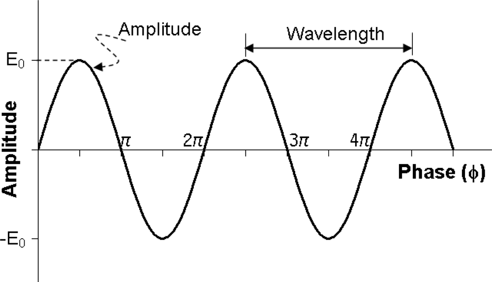
1.2. Phase Change–Basic Measurement of InSAR
1.3. Factors That Impact the Phase of an Image Pixel
1.4. InSAR and Interferogram
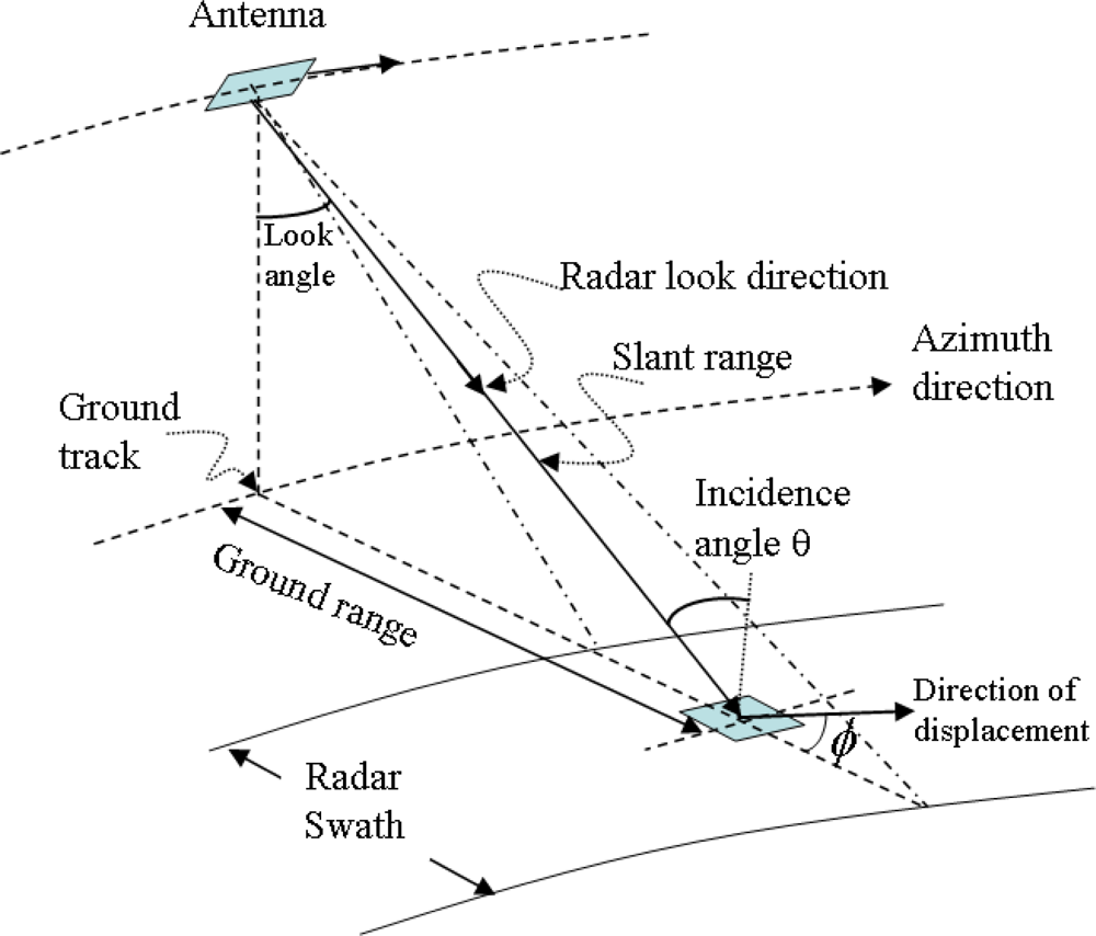
1.5. Range Change Detection from Interferogram
1.6. Selection of Interferometric Pair
1.7. Formation of an Interferogram
1.8 Limits of Conventional InSAR and New Remedy
1.9. SAR Sensors for InSAR and InSAR Software
2. Applications of InSAR
2.1. Application in Seismology
2.2. Application of InSAR in Volcanology
2.3. Applications of InSAR in Land Subsidence and Landslides
2.3.1. Land Subsidence and Uplift
2.3.2. Landslides
2.4. Applications of InSAR in Glaciology
2.5. Application of InSAR in Hydrology
2.5.1. Soil Moisture Monitoring
2.5.2. Water Level Measurement and Monitoring
2.6. Applications in Forestry
3. Discussion and Outlook
Acknowledgments
References
- Massonnet, D; Feigl, K.L. Radar interferometry and its application to changes in the Earth's surface. Rev. Geophys 1998, 36, 441–500. [Google Scholar]
- Balzter, H. Forest mapping and monitoring with interferometric synthetic aperture radar (InSAR). Prog. Phys. Geog 2001, 25, 159–177. [Google Scholar]
- Bamler, R.; Hartl, P. Synthetic aperture radar interferometry. Inverse Probl 1998, 14, R1–R54. [Google Scholar]
- Bürgmann, R.; Rosen, P.A.; Fielding, E.J. Synthetic aperture radar interferometry to measure Earth's surface topography and its deformation. Annu. Rev. Earth Pl. Sc 2000, 28, 169–209. [Google Scholar]
- Gens, R.; Van Genderen, J.L. SAR interferometry - Issues, techniques, applications. Int. J. Remote Sens 1996, 17, 1803–1835. [Google Scholar]
- Hanssen, R.F. Radar interferometry: data interpretation and error analysis. In Remote Sensing and Digital Image Processing; Kluwer Academic: Dordrecht, Netherlands, 2001; Volume 2. [Google Scholar]
- Klees, R.; Massonnet, D. Deformation measurements using SAR interferometry: potential and limitations. Geol. Mijnbouw 1999, 77, 161–176. [Google Scholar]
- Madsen, S.N.; Zebker, H.A. Imaging radar interferometry. In Principles and Applications of Imaging Radar: Manual of Remote Sensing; Henderson, F.M., Lewis, A.J., Eds.; Wiley: New York, USA, 1998; pp. 359–380. [Google Scholar]
- Massonnet, D. Satellite radar interferometry; Scientific American, 1997; pp. 46–53. [Google Scholar]
- Rosen, P.A.; Hensley, S.; Joughin, I.R.; Li, F.K.; Madsen, S.N.; Rodriguez, E.; Goldstein, R.M. Synthetic aperture radar interferometry. Proc. IEEE 2000, 88, 333–382. [Google Scholar]
- Zebker, H.A. Studying the Earth with interferometric radar. Comput. Sci. Eng 2000, 2, 52–60. [Google Scholar]
- Gabriel, A.K.; Goldstein, R.M.; Zebker, H.A. Mapping small elevation changes over large areas: differential radar interferometry. J. Geophys. Res 1989, 94, 9183–9191. [Google Scholar]
- Lu, Z.; Kwoun, O. Radarsat-1 and ERS interferometric analysis over southeastern coastal Louisiana: implication for mapping water-level changes beneath swamp forests. IEEE Trans. Geosci. Remot. Sen 2008, 46, 2167–2184. [Google Scholar]
- Bonforte, A.; Ferretti, A.; Prati, C.; Puglisi, G.; Rocca, F. Calibration of atmospheric effects on SAR interferograms by GPS and local atmosphere models: first results. J. Atmos. Sol.-Terr. Phys 2001, 63, 1343–1357. [Google Scholar]
- Closa, J. The influence of orbit precision in the quality of ERS SAR interferometric data. Tech. Rep. ES-TN-APP-APM-JC01, ESA,. 1998. Available at: http://earth.esa.int/ers/sysutil/ORB_QL.html. (Accessed on November 26, 2008).
- Scharroo, R.; Visser, P.N.A.M.; Mets, J.G. Precise orbit determination and gravity field improvement for the ERS satellites. J. Geophys. Res 1998, 103, 8113–8127. [Google Scholar]
- Murakami, M.; Tobita, M.; Fujiwara, S.; Saito, T.; Masaharu, H. Coseismic crustal deformations of the 1994 Northridge, California, earthquake detected by interferometric JERS 1 synthetic aperture radar. J. Geophys. Res 1996, 101, 8605–8614. [Google Scholar]
- Delacourt, C.; Briole, P.; Achache, J. Tropospheric corrections of SAR interferograms with strong topography: Application to Etna. Geophys. Res. Lett 1998, 25, 2849–2852. [Google Scholar]
- Rosen, P.A.; Hensley, S.; Zebker, H.A.; Webb, F.H.; Fielding, E.J. Surface deformation and coherence measurements of Kilauea volcano, Hawaii, from SIR-C radar interferometry. J. Geophys. Res 1996, 101. [Google Scholar]
- Williams, S.; Boch, Y.; Fang, P. Integrated satellite interferometry: tropospheric noise, GPS estimates and implications for interferometric synthetic aperture radar products. J. Geophys. Res 1998, 103, 27051–27067. [Google Scholar]
- Zebker, H.A.; Rosen, P.A.; Hensley, S. Atmospheric effects in interferometric synthetic aperture radar surface deformation and topographic maps. J. Geophys. Res 1997, 102, 7547–7563. [Google Scholar]
- Nolan, M.; Fatland, D. R. Penetration depth as a DInSAR observable and proxy for soil moisture. IEEE Trans. Geosci. Remot. Sen 2003, 41, 532–537. [Google Scholar]
- Nolan, M.; Fatland, D.R.; Hinzman, L. DInSAR measurement of soil moisture. IEEE Trans. Geosci. Remot. Sen 2003, 41, 2802–2813. [Google Scholar]
- Goldstein, R.M.; Werner, C.L. Radar interferogram filtering for geophysical applications. Geophys. Res. Lett 1998, 25, 4035–4038. [Google Scholar]
- Costantini, M. A novel phase unwrapping method based on network programming. IEEE Trans. Geosci. Remot. Sen 1998, 36, 813–821. [Google Scholar]
- Costantini, M.; Farina, A.; Zirilli, F. A fast phase unwrapping algorithm for SAR interferometry. IEEE Trans. Geosci. Remot. Sen 1999, 37, 452–460. [Google Scholar]
- Fornaro, G.; Franceschetti, G.; Lanari, R. Interferometric SAR phase unwrapping using Green's formulation. IEEE Trans. Geosci. Remot. Sen 1996, 34, 720–727. [Google Scholar]
- Fornaro, G.; Sansosti, E. A two-dimensional region growing least squares phase unwrapping algorithm for interferometric SAR processing. IEEE Trans. Geosci. Remot. Sen 1999, 37, 2215–2226. [Google Scholar]
- Ghiglia, D; Pritt, M.D. Two-dimensional Phase Unwrapping: Theory, Algorithms and Software; Wiley Interscience: New York, NY, USA, 1998. [Google Scholar]
- Lin, Q.; Vesecky, J.F.; Zebker, H.A. Phase unwrapping through fringe-line detection in synthetic-aperture radar interferometry. Appl. Opt 1994, 33, 201–208. [Google Scholar]
- Lyuboshenko, I.; Maitre, H. Phase unwrapping for interferometric Synthetic Aperture Radar by use of Helmholtz equation eigenfunctions and the first Green's identity. J. Opt. Soc. Am. A-Opt. Image. Sci 1999, 16, 378–395. [Google Scholar]
- Pritt, M.D. Phase unwrapping by means of multigrid techniques for interferometric SAR. IEEE Trans. Geosci. Remot. Sen 1996, 34, 728–738. [Google Scholar]
- Trouve, E.; Nicolas, J.M.; Maitre, H. Improving phase unwrapping techniques by the use of local frequency estimates. IEEE Trans. Geosci. Remot. Sen 1998, 36, 1963–1972. [Google Scholar]
- Wang, Z.; Li, S. Phase unwrapping through a branch-cut-based cut-bridging and window-patching method. Appl. Opt 1999, 38, 805–814. [Google Scholar]
- Xu, W.; Cumming, I. A region-growing algorithm for InSAR phase unwrapping. IEEE Trans. Geosci. Remot. Sen 1999, 37, 124–134. [Google Scholar]
- Zebker, H.A.; Lu, Y.P. Phase unwrapping algorithms for radar interferometry: Residue-cut, least-squares, and synthesis algorithms. J. Opt. Soc. Am. A-Opt. Image. Sci 1998, 15, 586–598. [Google Scholar]
- Li, S.; Benson, C.; Gens, R.; Lingle, C. Motion patterns of Nabesna Glacier (Alaska) revealed by interferometric SAR techniques. Remote Sens. Environ 2008, 112, 3628–3638. [Google Scholar]
- Bürgmann, R.; Schmidt, D.; Nadeau, R.M.; d'Alessio, M.; Fielding, E.; Manaker, D.; McEvilly, T.V.; Murray, M.H. Earthquake potential along the northern Hayward fault, California. Science 2000, 289, 1178–1181. [Google Scholar]
- Zebker, H.A.; Villasenor, J. Decorrelation in interferometric radar echoes. IEEE Trans. Geosci. Remot. Sen 1992, 30, 950–959. [Google Scholar]
- Gelautz, M.; Leberl, F.; Kellerer-Pirklbauer, W. Image enhancement and evaluation: SAR layover and shadows. AEU – Archiv für Elektronik und Übertragungstechnik (International Journal of Electronics and Communications) 1996, 50, 100–105. [Google Scholar]
- Zebker, H.A.; Werner, C.L.; Rosen, P.A.; Hensley, S. Accuracy of topographic maps derived from ERS-1 interferometric radar. IEEE Trans. Geosci. Remot. Sen 1994, 32, 823–836. [Google Scholar]
- Goldstein, R.M.; Engelhardt, H.; Kamb, B.; Frolich, R.M. Satellite radar interferometry for monitoring ice sheet motion: application to an Antarctic ice stream. Science 1993, 262, 1525–1530. [Google Scholar]
- Catani, F.; Farinaa, P.; Morettia, S.; Nicob, G.; Strozzi, T. On the application of SAR interferometry to geomorphological studies: Estimation of landform attributes and mass movements. Geomorphology 2005, 66, 119–131. [Google Scholar]
- Ferretti, A.; Prati, C.; Rocca, F. Nonlinear subsidence rate estimation using Permanent Scatterers in Differential SAR Interferometry. IEEE Trans. Geosci. Remot. Sen 2000, 38, 2202–2212. [Google Scholar]
- Ferretti, A.; Prati, C.; Rocca, F. Permanent scatterers in SAR interferometry. IEEE Trans. Geosci. Remot. Sen 2001, 39, 8–20. [Google Scholar]
- Evans, D.L.; Alpers, W.; Cazenave, A.; Elachi, C.; Farr, T.; Glackin, D.; Holt, B.; Jones, L.; Liu, W.T.; McCandless, W.; Menard, Y.; Moore, R.; Njoku, E. Seasat – A 25-year legacy of success. Remote Sens. Environ 2005, 94, 384–404. [Google Scholar]
- Luscombe, A.P.; Feguson, I.; Shepherd, N.; Zimcik, D.G.; Naraine, P. The RADARSAT synthetic Aperture radar development. Can. J. Remote Sens 1993, 19, 298–310. [Google Scholar]
- D’Errico, M.; Fasano, G. Design of interferometric and bistatic mission phases of COSMO/SkyMed constellation. Acta Astronaut 2008, 62, 97–111. [Google Scholar]
- Duchossois, G.; Martin, P. ERS-1 and ERS-2 tandem operations. ESA Bull 1995, 83, 54–60. [Google Scholar]
- Wegmüller, U; Werner, C. L. Gamma SAR processor and interferometry software. Eur. Space Agency Spec. Publ 1997, ESA SP-414, 1686–1692. [Google Scholar]
- Werner, C.; Wegmüller, U.; Strozzi, T.; Wiesmann, A. Gamma SAR and interferometric processing software. Proceedings of ERS-ENVISAT Symposium, Gothenburg, Sweden, 15–20 October 2000; Sawaya-Lacoste, H., Ed.; European Space Agency Publications Division: Noordwijk, 2001. [Google Scholar]
- Massonnet, D.; Rabaute, T. Radar interferometry: limits and potential. IEEE Trans. Geosci. Remot. Sen 1993, 31, 455–464. [Google Scholar]
- Massonnet, D.; Feigl, K.L. Satellite radar interferometric map of the coseismic deformation field of the M=6.1 Eureka Valley, California earthquake of May 17, 1993. Geophys. Res. Lett 1995, 22, 1541–1544. [Google Scholar]
- Delouis, B.; Giardini, D.; Lundgren, P.; Salichon, J. Joint inversion of INSAR, GPS, teleseismic, and strong-motion data for the spatial and temporal distribution of earthquake slip: application to the 1999 İzmit mainshock. Bull. Seismol. Soc. Am 2002, 92, 278–299. [Google Scholar]
- Feigl, K.L.; Sarti, F.; Vadon, H.; McClusky, S.; Ergintav, S.; Durand, P.; Bürgmann, R.; Rigo, A.; Massonnet, D.; Reilinger, R. Estimating slip distribution for the İzmit mainshock from coseismic GPS, ERS-1, RADARSAT, and SPOT measurements. Bull. Seismol. Soc. Am 2002, 92, 138–160. [Google Scholar]
- Árnadóttir, T.; Jónsson, S.; Pollitz, F.F.; Jiang, W.; Feigl, K.L. Postseismic deformation following the June 2000 earthquake sequence in the south Iceland seismic zone. J. Geophys. Res 2005, 110, B12308. [Google Scholar]
- Cakir, Z.; Akoglu, A.M.; Belabbes, S.; Ergintav, S.; Meghraoui, M. Creeping along the North Anatolian Fault at Ismetpasa (Western Turkey): rate and extent from InSAR. Earth Planet. Sci. Lett 2005, 238, 225–234. [Google Scholar]
- Massonnet, D.; Rossi, M.; Carmona, C.; Adragna, F.; Peltzer, G.; Feigl, K.; Rabaute, T. The displacement field of the Landers earthquake mapped by radar interferometry. Nature 1993, 364, 138–142. [Google Scholar]
- Pedersen, R.; Sigmundsson, F.; Feigl, K.L.; Árnadóttir, T. Coseismic interferograms of two Ms = 6.6 earthquakes in the south Iceland seismic zone, June 2000. Geophys. Res. Lett 2001, 28, 3341–3344. [Google Scholar]
- Peltzer, G.; Rosen, P.; Rogez, F.; Hudnut, K. Postseismic rebound in fault step-overs caused by pore fluid flow. Science 1996, 273, 1202–1204. [Google Scholar]
- Cakir, Z.; Meghraoui, M.; Akoglu, A.M.; Jabour, N.; Belabbes, S.; Ait-Brahim, L. Surface deformation associated with the Mw 6.4, February 24, 2004 Al Hoceima (Morocco) earthquake deduced from InSAR: implications for the active tectonics along North Africa. Bull. Seismol. Soc. Am 2006, 96, 59–68. [Google Scholar]
- Akoglu, A.M.; Cakir, Z.; Meghraoui, M.; Belabbes, S.; El Alami, S.O.; Ergintav, S.; Akyüz, H.S. The 1994–2004 Al Hoceima (Morocco) earthquake sequence: Conjugate fault ruptures deduced from InSAR. Earth Planet. Sci. Lett 2006, 252, 467–480. [Google Scholar]
- Pedersen, R.; Jónsson, S.; Árnadóttir, T.; Sigmundsson, F.; Feigl, K.L. Fault slip distribution of two Mw = 6.5 earthquakes in south Iceland estimated from joint inversion of InSAR and GPS measurements. Earth Planet. Sci. Lett 2003, 213, 487–502. [Google Scholar]
- Pritchard, M. E.; Fielding, E. J. A study of the 2006 and 2007 earthquake sequence of Pisco, Peru, with InSAR and teleseismic data. Geophys. Res. Lett 2008, 35, L09308. [Google Scholar]
- Anghel, M. On the effective dimension and dynamic complexity of earthquake faults. Chaos, Solitons Fractals 2004, 19, 399–420. [Google Scholar]
- Fialko, Y. Probing the mechanical properties of seismically active crust with space geodesy: Study of the coseismic deformation due to the 1992 Mw 7.3 Landers (southern California) earthquake. J. Geophys. Res 2004, 109, B03307. [Google Scholar]
- Froger, J.-L.; Fukushimana, Y.; Briole, P.; Staudachr, T.; Souriot, T.; Villneuve, N. The deformation field of the August 2003 eruption at Piton de la Fournaise, Reunion Island, mapped by ASAR interferometry. Geophys. Res. Lett 2004, 31, L14601. [Google Scholar]
- Funning, G.J.; Parsons, B.; Wright, T.J.; Jackson, J.A.; Fielding, E.J. Surface displacements and source parameters of the 2003 Bam (Iran) earthquake from Envisat advanced synthetic aperture radar imagery. J. Geophys. Res 2005, 110, B09406. [Google Scholar]
- Bechor, N.B.D.; Zebker, H.A. Measuring two-dimensional movements using a single InSAR pair. Geophys. Res. Lett 2006, 33, L16311. [Google Scholar]
- Mellors, R.; Bunyapanasarn, T.; Panahi, B. InSAR analysis of the Absheron Peninsula and nearby areas, Azerbaijan. In Mud Volcanoes, Geodynamics and Seismicity; Martinelli, G., Panahi, B., Eds.; NATO Science Series,; Springer, 2005; pp. 201–209. [Google Scholar]
- Pedersen, R.; Sigmundsson, F. Temporal development of the 1999 intrusive episode in the Eyjafjallajökull volcano, Iceland, derived from InSAR images. Bull. Volcanol 2006, 68, 377–393. [Google Scholar]
- Mogi, K. Relations between the eruptions of various volcanoes and the deformation of the ground surfaces around them. Bull. Earthquake Res. Institute, Univ. Tokyo 1958, 36, 99–134. [Google Scholar]
- Okada, Y. Surface deformation due to shear and tensile faults in a half-space. Bull. Seismol. Soc. Am 1985, 75, 1135–1154. [Google Scholar]
- Okada, Y.; Yamamoto, E. Dyke intrusion model for the 1989 seismovolcanic activity off Ito, central Japan. J. Geophys. Res 1991, 96, 10361–10376. [Google Scholar]
- Árnadóttir, T.; Sigmundsson, F.; Delaney, P. T. Sources of crustal deformation associated with the Krafla, Iceland, eruption of September 1984. Geophys. Res. Lett 1998, 25, 1043–1046. [Google Scholar]
- Dvorak, J.J.; Dzurisin, D. Volcano geodesy: the search for magma reservoirs and the formation of eruptive vents. Rev. Geophys 1997, 35, 343–384. [Google Scholar]
- Dzurisin, D. A comprehensive approach to monitoring volcano deformation as a window on the eruption cycle. Rev. Geophys 2003, 41, 1009, doi:1010.1029/2001RG000107. [Google Scholar]
- Lu, Z.; Dzurisin, D.; Wicks, C, Jr.; Power, J.; Kwoun, O.; Rykhus, R. Diverse deformation patterns of Aleutian volcanoes from satellite interferometric synthetic aperture radar (InSAR). In Volcanism and Subduction; Eichelberger, J.C., Gordeev, E., Izbekov, P., Kasahara, M., Lees, J.M., Eds.; AGU Monograph Series 172,; American Geophysical Union: Washington, D.C., 2007; pp. 249–261. 2007b. [CrossRef]
- Lu, Z.; Masterlark, T.; Dzurisin, D.; Rykhus, R.; Wicks, C., Jr. Magma supply dynamics at Westdahl volcano, Alaska, modeled from satellite radar interferometry. J. Geophys. Res 2003, 108. doi:2310.1029/2002JB002311. [Google Scholar]
- Pritchard, M.E.; Simons, M. A satellite geodetic survey of large-scale deformation of volcanic centres in the central Andes. Nature 2002, 418, 167–171. [Google Scholar]
- Amelung, F.; Jonsson, S.; Zebker, H.; Segall, P. Widespread uplift and ‘trapdoor’ faulting on Galapagos volcanoes observed with radar interferometry. Nature 2000, 407, 993–996. [Google Scholar]
- Feigl, K.L.; Gasperi, J.; Sigmundsson, F.; Rigo, A. Crustal deformation near Hengill volcano, Iceland 1993–1998: coupling between magmatic activity and faulting inferred from elastic modeling of satellite radar interferograms. J. Geophys. Res 2000, 105, 25655–25670. [Google Scholar]
- Massonnet, D.; Briole, P.; Arnaud, A. Deflation of Mount Etna monitored by spaceborne radar interferometry. Nature 1995, 375, 567–570. [Google Scholar]
- Lu, Z.; Mann, D.; Freymueller, J. Satellite radar interferometry measures deformation at Okmok volcano. EOS 1998, 79, 461–468. [Google Scholar]
- Avallone, A.; Zollo, A.; Briole, P.; Delacourt, C.; Beauducel, F. Subsidence of Campi Flegrei (Italy) detected by SAR interferometry. Geophys. Res. Lett 1999, 26, 2303–2306. [Google Scholar]
- de Zeeuw-van Dalfsen, E.; Pedersen, R.; Sigmundsson, F.; Pagli, C. Satellite Radar Interferometry 1993–1999 suggests deep accumulation of magma near the crust-mantle boundary at the Krafla volcanic system, Iceland. Geophys. Res. Lett 2004, 31, L13611. [Google Scholar] [CrossRef]
- Froger, J.L.; Remy, D.; Bonvalot, S.; Legrand, D. Two scales of inflation at Lastarria-Cordon del Azufre volcanic complex, cenral Andes, revealed from ASAR-ENVISAT interferometric data. Earth Planet. Sci. Lett 2007, 255, 148–163. [Google Scholar]
- Pritchard, M.E.; Simons, M. An InSAR-based survey of volcanic deformation in the central Andes. Geochem. Geophys. Geosyst 2004, 5, Q02002. [Google Scholar] [CrossRef]
- Ruch, J.; Anderssohn, J.; Walter, T.R.; Motagh, M. Caldera-scale inflation of the Lazufre volcanic area, South America: Evidence from InSAR. J. Volcanol. Geotherm. Res 2008, 174, 337–344. [Google Scholar]
- Geist, D.J.; Harpp, K.S.; Naumann, T.R.; Poland, M.; Chadwick, W.W.; Hall, M.; Rader, E. The 2005 eruption of Sierra Negra volcano, Galápagos, Ecuador. Bull. Volcanol 2008, 70, 655–673. [Google Scholar]
- Abidin, H.Z.; Davies, R.J.; Kusuma, M.A.; Andreas, H.; Deguchi, T. Subsidence and uplift of Sidoarjo (East Java) due to the eruption of the Lusi mud volcano (2006–present). Environ. Geol. [CrossRef]
- Lundgren, P.; Casu, F.; Manzo, M.; Pepe, A.; Berardino, P.; Sansosti, E.; Lanari, R. Gravity and magma induced spreading of Mount Etna volcano revealed by satellite radar interferometry. Geophys. Res. Lett 2004, 31, L04602. [Google Scholar] [CrossRef]
- Palano, M.; Puglisi, G.; Gresta, S. Ground deformation patterns at Mt. Etna from 1993 to 2000 from joint use of InSAR and GPS techniques. J. Volcanol. Geotherm. Res 2008, 169, 99–120. [Google Scholar]
- Poland, M.; Bürgmann, R.; Dzurisin, D.; Lisowski, M.; Masterlark, T.; Owen, S.; Fink, J. Constraints on the mechanism of long-term, steady subsidence at Medicine Lake volcano, northern California, from GPS, leveling, and InSAR. J. Volcanol. Geotherm. Res 2006, 150, 55–78. [Google Scholar]
- Yun, S.; Segall, P.; Zebker, H. Constraints on magma chamber geometry at Sierra Negra Volcano, Galapagos Islands, based on InSAR observations. J. Volcanol. Geotherm. Res 2006, 150, 232–243. [Google Scholar]
- Fialko, Y.; Simons, M.; Khazan, Y. Finite source modelling of magmatic unrest in Socorro, New Mexico, and Long Valley, California. Geophys. J. Int 2001, 146, 191–200. [Google Scholar]
- Lagios, E.; Sakkas, V.; Parcharidis, Is.; Dietrich, V. Ground deformation of Nisyros Volcano (Greece) for the period 1995–2002: Results from DInSAR and DGPS observations. Bull. Volcanol 2005, 68, 201–214. [Google Scholar]
- Parcharidis, I.; Lagios, E. Deformation in Nisyros volcano (Greece) using differential radar interferometry. Bull. Geol. Soc. Greece 2001, 34, 1587–1594. [Google Scholar]
- Sachpazi, M.; Kontoes, C.; Voulgaris, N.; Laigle, M.; Vougioukalakis, G.; Sykioti, O.; Stavrakakis, G.; Baskoutas, J.; Kalogeras, J.; Lepine, J.C. Seismological and SAR signature of unrest at Nisyros Caldera, Greece. J. Volcanol. Geotherm. Res 2002, 116, 19–33. [Google Scholar]
- Sykioti, O.; Kontoes, C.; Elias, P.; Briole, P.; Sachpazi, M.; Paradissis, D.; Kotsis, I. Ground deformation at Nisyros volcano (Greece) detected by ERS-2 SAR differential interferometry. Int. J. Remote Sens 2003, 24, 183–188. [Google Scholar]
- de Zeeuw-van Dalfsen, E.; Rymer, H.; Williams-Jones, G.; Sturkell, E.; Sigmundsson, F. Integration of micro-gravity and geodetic data to constrain shallow system mass changes at Krafla Volcano, N Iceland. Bull. Volcanol 2006, 68, 420–431. [Google Scholar]
- Berardino, P.; Fornaro, G.; Lanari, R.; Sansosti, E. A new algorithm for surface deformation monitoring based on small baseline differential SAR interferograms. IEEE Trans. Geosci. Remote Sens 2002, 40, 2375–2383. [Google Scholar]
- Borgia, A.; Lanari, R.; Sansosti, E.; Tesauro, M.; Berardino, P.; Fornaro, G.; Neri, M.; Murray, J.B. Actively growing anticlines beneath Catania from distal motion of Mount Etna's decollement measured by SAR interferometry and GPS. Geophys. Res. Lett 2000, 27, 3409–3412. [Google Scholar]
- Froger, J.-L.; Merle, O.; Briole, P. Active spreading and regional extension of Mount Etna imaged by SAR interferometry. Earth Planet. Sci. Lett 2001, 187, 245–258. [Google Scholar]
- Lanari, R.; Lundgren, P.; Sansosti, E. Dynamic deformation of Etna volcano observed by satellite radar interferometry. Geophys. Res. Lett 1998, 25, 1541–1544. [Google Scholar]
- Lundgren, P.; Usai, S.; Sansosti, E.; Lanari, R.; Tesauro, M.; Fornaro, G.; Berardino, P. Modeling surface deformation observed with synthetic aperture radar interferometry at Campi Flegrei caldera. J. Geophys. Res 2001, 106, 19355–19366. [Google Scholar]
- Lundgren, P.; Berardino, P.; Coltelli, M.; Fornaro, G.; Lanari, R.; Puglisi, G.; Sansosti, E.; Tesauro, M. Coupled magma chamber inflation and sector collapse slip observed with synthetic aperture radar interferometry on Mt. Etna volcano. J. Geophys. Res 2003, 108, 2247. [Google Scholar] [CrossRef]
- National Research Council. Mitigating Losses From Land Subsidence in the United States; Natl. Acad. Press: Washington, D.C., 1991; pp. 1–58. Available online at: http://books.nap.edu/openbook.php?record_id=1796&page=R1. (Accessed on December 218, 2008).
- Galloway, D.L.; Hudnut, K.W.; Ingebritsen, S.E.; Phillips, S.P.; Peltzer, G.; Rogez, F.; Rosen, P. A. Detection of aquifer system compaction and land subsidence using interferometric synthetic aperture radar, Antelope Valley, Mojave Desert, California. Water Resour. Res 1998, 34, 2573–2585. [Google Scholar]
- Prokopovich, N.P.; Marriott, M.J. Cost of subsidence to the Central Valley Project, California. Assoc. Eng. Geol. Bull 1983, 20, 3325–3332. [Google Scholar]
- Carbognina, L.; Teatini, P.; Tosi, L. Eustacy and land subsidence in the Venice Lagoon at the beginning of the new millennium. J. Marine Syst 2004, 51, 345–353. [Google Scholar]
- Teatini, P.; Tosi, L.; Strozzi, T.; Carbognin, L.; Wegmüller, U.; Rizzetto, F. Mapping regional land displacements in the Venice coastland by an integrated monitoring system. Remote Sens. Environ 2005, 98, 403–413. [Google Scholar]
- Tosi, L.; Carbognin, L.; Teatini, P.; Strozzi, T.; Wegmüller, U. Evidences of the present relative land stability of Venice, Italy, from land, sea, and space observations. Geophys. Res. Lett 2002, 29, 1562. [Google Scholar] [CrossRef]
- Raucules, D.; Le Mouélic, S.; Carnec, C.; King, C. Urban subsidence in the city of Prato (Italy) monitored by satellite radar interferometry. Int. J. Remote Sens 2003, 20, 891–897. [Google Scholar]
- Hoffmann, J.; Zebker, H.; Galloway, D.; Amelung, F. Seasonal subsidence and rebound in Las Vegas valley, Nevada, observed by synthetic aperture radar interferometry. Water Resour. Res 2001, 37, 1551–1566. [Google Scholar]
- Lu, Z.; Danskin, W.R. InSAR analysis of natural recharge to define structure of a ground-water basin, San Bernardino, California. Geophys. Res. Lett 2001, 28, 2661–2664. [Google Scholar]
- Bawden, G.; Thatcher, W.; Stein, R.S.; Hudnut, K.W.; Peltzer, G. Tectonic contraction across Los Angeles after removal of groundwater pumping effects. Nature 2001, 412, 812–8151. [Google Scholar]
- Watson, K.M.; Bock, Y.; Sandwell, D.T. Satellite interferometric observations of displacements associated with seasonal groundwater in the Los Angeles basin. J. Geophys. Res 2002, 107, 2074. [Google Scholar] [CrossRef]
- Schmidt, D.A.; Bürgmann, R. Time-dependent land uplift and subsidence in the Santa Clara valley, California, from a large interferometric synthetic aperture radar data set. J. Geophys. Res 2003, 108, 2416. [Google Scholar] [CrossRef]
- Hole, J.K.; Bromley, C.J.; Stevens, N.F.; Wadge, G. Subsidence in the geothermal fields of the Taupo Volcanic Zone, New Zealand from 1996 to 2005 measured by InSAR. J. Volcanol. Geotherm. Res 2007, 166, 125–146. [Google Scholar]
- Narasimhan, T.N. Subsidence due to geothermal fluid withdrawal. 1984, 6, 35–66. [Google Scholar]
- Massonnet, D.; Holzer, T.; Vadon, H. Land subsidence caused by the East Mesa geothermal field, California, observed using SAR interferometry. Geophys. Res. Lett 1997, 24, 901–904, (Correction, Geophys. Res. Lett. 1998, 25, 3213).. [Google Scholar]
- Vadon, H.; Sigmundsson, F. 1992–1995 Crustal deformation at Mid-Atlantic ridge, SW Iceland, mapped by radar interferometry. Science 1997, 275, 193–197. [Google Scholar]
- Carnec, C.; Fabriol, H. Monitoring and modeling land subsidence at the Cerro Prieto geothermal field, Baja California, Mexico, using SAR interferometry. Geophys. Res. Lett 1999, 26, 1211–1214. [Google Scholar]
- Fialko, Y.; Simons, M. Deformation and seismicity in the Coso geothermal area, Inyo County, California: observations and modeling using satellite radar interferometry. J. Geophys. Res 2000, 105, 21781–21794. [Google Scholar]
- Vasco, D.W.; Wicks, C.W.; Karasaki, K.; Marques, O. Geodetic imaging: reservoir monitoring using satellite interferometry. Geophys. J. Int 2002, 149, 555–571. [Google Scholar]
- Gray, R.E.; Bruhn, R.W. Coal mine subsidence - eastern United States. 1984, 6, 35–66. [Google Scholar]
- Dunrud, C.R. Geology 1984, 6, 35–66.
- Carnec, C.; Massonnet, D.; King, C. Two examples of the application of SAR interferomety to sites of small extent. Geophys. Res. Lett 1996, 23, 3579–3582. [Google Scholar]
- Carnec, C.; Delacourt, C. Three years of mining subsidence monitored by SAR interferometry, near Gardanne, France. J. Appl. Geophys 2000, 43, 43–54. [Google Scholar]
- Snieder, R.; Hubbard, S.; Haney, M.; Bawden, G.; Hatchell, P.; Revil, A.; DOE Geophysical Monitoring Working Group. Advanced noninvasive geophysical monitoring techniques. Annu. Rev. Earth Pl. Sc 2007, 35, 653–683. [Google Scholar]
- Stancliffe, R.P.W.; van der Kooij, M.W.A. The use of satellite-based radar interferometry to monitor production activity at the Cold Lake heavy oil field, Alberta, Canada. AAPG Bull 2001, 85, 781–793. [Google Scholar]
- Rott, H.; Scheuchl, B.; Siegel, A.; Grasemann, B. Monitoring very slow slope motion by means of SAR interferometry: a case study from a mass waste above a reservoir in the Otzal Alps, Austria. Geophys. Res. Lett 1999, 26, 1629–1632. [Google Scholar]
- Leva, D.; Nico, G.; Tarchi, D.; Fortuny-Guasch, J.; Sieber, A. J. Temporal analysis of a landslide by means of a ground-based SAR interferometer. IEEE Trans. Geosci. Remote Sens 2003, 41, 745–752. [Google Scholar]
- Berardino, P.; Costantini, M.; Franceschetti, G.; Iodice, A.; Pietranera, L.; Rizzo, V. Use of differential SAR interferometry in monitoring and modelling large slope instability at Maratea (Basilicata, Italy). Eng. Geol 2003, 68, 31–51. [Google Scholar]
- Bovenga, F.; Nutricato, R.; Refice, A.; Wasowski, J. Engineering, Application of multi-temporal differential interferometry instability detection in urban/peri-urban areas. Geology 2006, 88, 218–239. [Google Scholar]
- Colesanti, C.; Ferretti, A.; Prati, C.; Rocca, F. Monitoring landslides and tectonic motion with the Permanent Scatterers Technique. Eng. Geol 2003, 68, 3–14. [Google Scholar]
- Colesanti, C.; Wasowski, J. Investigating landslides with spaceborne Synthetic Aperture Radar (SAR) interferometry. Eng. Geol 2006, 88, 173–199. [Google Scholar]
- Fruneau, B.; Achace, J.; Delacourt, C. Observation and modelling of the Sant-Etienne-de Tinée landslide using SAR interferometry. Tectonophysics 1996, 265, 181–190. [Google Scholar]
- Hilley, G.E.; Bürgmann, R.; Ferretti, A.; Novali, F.; Rocca, F. Dynamics of slow-moving landslides from permanent scatterers analysis. Science 2004, 304, 1952–1955. [Google Scholar]
- Rizzo, V.; Tesauro, M. SAR interferometry and field data of Randazzo landslide (Eastern Sicily, Italy). Phys. Chem. Earth 2000, 25, 771–780. [Google Scholar]
- Strozzi, T.; Farina, P.; Corsini, A.; Ambrosi, C.; Thüring, M.; Zilger, J.; Wiesmann, A.; Wegmüller, U.; Werner, C. Survey and monitoring of landslide displacements by means of L-band satellite SAR interferometry. Landslides 2005, 2, 193–201. [Google Scholar]
- Nerem, R.S.; Leuliette, É.; Cazenave, A. Present-day sea-level change: a review. C. R. Geoscience 2006, 338, 1077–1083. [Google Scholar]
- Larour, E.; Rignot, E.; Joughin, I.; Aubry, D. Rheology of the Ronne Ice Shelf, Antarctica, inferred from satellite radar interferometry data using an inverse control method. Geophys. Res. Lett 2005, 32, L05503. [Google Scholar]
- Fatland, D.R.; Lingle, C.S. Analysis of the 1993–95 Bering Glacier (Alaska) surge using differential SAR interferometry. J. Glaciol 1998, 44, 532–546. [Google Scholar]
- Fischer, A.; Rott, H.; Bjfrnsson, H. Observation of recent surges of Vatnajfkull, Iceland, by means of ERS SAR interferometry. Ann. Glaciol 2003, 37, 69–76. [Google Scholar]
- Joughin, I.R.; Winebrenner, D.P.; Fahnestock, M.A. Observations of ice-sheet motion in Greenland using satellite radar interferometry. Geophys. Res. Lett 1995, 22, 571–574. [Google Scholar]
- Kwok, R.; Fahnestock, M.A. Ice sheet motion and topography from radar interferometry. IEEE Trans. Geosci. Remote Sens 1996, 34, 189–200. [Google Scholar]
- Rignot, E.J.; Jezek, K.C.; Sohn, H.G. Ice flow dynamics of the Greenland ice sheet from SAR interferometry. Geophys. Res. Lett 1995, 22, 575–578. [Google Scholar]
- Rignot, E.J. Fast reaction of a waste Antarctic glacier. (Pine Island Glacier). Science 1998, 281, 549–551. [Google Scholar]
- Joughin, I.; Winebrenner, D.; Fahnestock, M.; Kwok, R.; Krabill, W. Measurement of ice-sheet topography using satellite-radar interferometry. J. Glaciol 1996a, 42, 10–22. [Google Scholar]
- Gray, A.L.; Short, N.; Mattar, K.E.; Jezek, K.C. Velocities and flux of the Filchner Ice Shelf and its tributaries determined from speckle tracking interferometry. Can. J. Remote Sens 2001, 27, 193–206. [Google Scholar]
- Joughin, I.R.; Kwok, R.; Fahnestock, M.A. Interferometric estimation of the three-dimensional ice-flow velocity vector using ascending and descending passes. IEEE Trans. Geosci. Remote Sens 1998, 36, 25–37. [Google Scholar]
- Michel, R.; Rignot, E. Flow of Glaciar Moreno, Argentina, from repeat-pass Shuttle Imaging Radar images: Comparison of the phase correlation method with radar interferometry. J. Glaciol 1999, 45, 93–100. [Google Scholar]
- Mohr, J.J.; Reeh, N.; Madsen, S.N. Three dimensional glacial flow and surface elevation measured with radar interferometry. Nature 1998, 391, 273–276. [Google Scholar]
- Rabus, R.T.; Fatland, D.R. Comparison of SAR-interferometric and surveyed velocities on a mountain glacier: Black Rapids Glacier, Alaska, U.S.A. J. Glaciol 2000, 46, 119–128. [Google Scholar]
- Rott, H.; Stuefer, M.; Siegel, A.; Skvarca, P.; Eckstaller, A. Mass fluxes dynamics of Moreno Glacier, Southern Patagonia Icefield. Geophys. Res. Lett 1998, 25, 1407–1410. [Google Scholar]
- Li, S.; Matthew, S. Patterns of wind-drifted snow on the Alaskan arctic slope, detected with ERS-1 interferometric SAR. J. Glaciol 2002, 48, 495–504. [Google Scholar]
- Oveisgharan, S.; Zebker, H.A. Estimating snow accumulation from InSAR correlation observations. IEEE Trans. Geosci. Remote Sens 2007, 45, 10–20. [Google Scholar]
- Jónsson, S.; Adam, N.; Björnsson, H. Effects of subglacial geothermal activity observed by satellite radar interferometry. Geophys. Res. Lett 1998, 25, 1059–1062. [Google Scholar]
- Björnsson, H.; Rott, H.; Gudmundsson, S.; Fischer, A.; Siegel, A.; Gudmundsson, M.T. Glacier–volcano interactions deduced by SAR interferometry. J. Glaciol 2001, 47, 58–70. [Google Scholar]
- Magnússon, E.; Rott, H.; Björnsson, H.; Pálsson, F. The impact of jökulhlaups on basal sliding observed by SAR interferometry on Vatnajökull, Iceland. J. Glaciol 2007, 53, 232–240. [Google Scholar]
- Vieli, A.; Payne, A.J.; Shepherd, A.; Du, Z. Causes of pre-collapse changes of the Larsen B ice shelf: Numerical modelling and assimilation of satellite observations. Earth Planet. Sci. Lett 2007, 259, 297–306. [Google Scholar]
- Gray, L.; Joughin, I.; Tulaczyk, S.; Spikes, V.B.; Bindschadler, R.; Jezek, K. Evidence for subglacial water transport in the West Antarctic Ice Sheet through three-dimensional satellite radar interferometry. Geophys. Res. Lett 2005, 32, L03501. [Google Scholar]
- Furuya, M.; Wahr, J.M. Water level changes at an ice-dammed lake in west Greenland inferred from InSAR data. Geophys. Res. Lett 2005, 32, L14501. [Google Scholar]
- Smith, L.C.; Alsdorf, D.E.; Magilligan, F.J.; Gomez, B.; Mertes, L.A.K.; Smith, N.D.; Garvin, J.B. Estimates of erosion, deposition, and net volumetric change caused by the 1996 Skeidarársandur jökulhlaup, Iceland, from synthetic aperture radar interferometry. Water Resour. Res 2000, 36, 1583–1594. [Google Scholar]
- König, M.; Winther, J.G.; Isaksson, E. Measuring snow and glacier ice properties from satellite. Rev. Geophys 2001, 39, 1–27. [Google Scholar]
- Strozzi, T.; Luckman, A.; Murray, T.; Wegmqller, U.; Werner, C. Glacier motion estimation using SAR offset-tracking procedures. IEEE Trans. Geosci. Remote Sens 2002, 40, 2384–2391. [Google Scholar]
- Quincey, D.J.; Richardson, S.D.; Luckman, A.; Lucas, R.M.; Reynolds, J.M.; Hambrey, M.J.; Glasser, N. F. Early recognition of glacial lake hazards in the Himalaya using remote sensing datasets. Global Planet. Change 2007, 56, 137–152. [Google Scholar]
- Berthier, E.; Vadon, H.; Baratoux, D.; Arnaud, Y.; Vincent, C.; Feigl, K.L.; Rémy, F.; Legrésy, B. Surface motion of mountain glaciers derived from satellite optical imagery. Remote Sens. Environ 2005, 95, 14–28. [Google Scholar]
- Blaes, X.; Defourny, P. Retrieving crop parameters based on tandem ERS 1/2 interferometric coherence images. Remote Sens. Environ 2003, 88, 374–385. [Google Scholar]
- Shepherd, A.; Wingham, D.J.; Mansley, J.A.D.; Corr, H.F.J. Inland thinning of Pine Island Glacier, West Antarctica. Science 2001, 291, 862–864. [Google Scholar]
- Wangensteen, B.; Weydahl, D.J.; Hagen, J.O. Mapping glacier velocities on Svalbard using ERS tandem DInSAR data. Norsk Geografisk Tidsskrift–Norwegian. J. Geog 2005, 59, 276–285. [Google Scholar]
- Muskett, R.R.; Lingle, C.S.; Sauber, J.M.; Rabus, B.T.; Tangborn, W.V. Acceleration of surface lowering on the tidewater glaciers of Icy Bay, Alaska, U.S.A. from InSAR DEMs and ICESat altimetry. Earth Planet. Sci. Lett 2008, 265, 345–359. [Google Scholar]
- Benson, C.S.; Follett, A.B. Application of photogrammetry to the study of volcano-glacier interactions on Mount Wrangell, Alaska. Photogramm. Eng. Rem. S 1986, 52, 813–827. [Google Scholar]
- Joughin, I.; Kwok, R.; Fahnestock, M. Estimation of ice-sheet motion using satellite radar interferometry: method and error analysis with application to Humboldt Glacier, Greenland. J. Glaciol 1996, 42, 564–575. [Google Scholar]
- Smith, L.C. Emerging applications of interferometric synthetic aperture radar in geomorphology and hydrology. Ann. Assoc. Am. Geog 2002, 92, 385–398. [Google Scholar]
- Makkeasorn, A.; Chang, N.B.; Beaman, M.; Wyatt, C.; Slater, C. Soil moisture prediction in a semi-arid reservoir watershed using RADARSAT satellite image and genetic programming. Water Resour. Res 2006, 42, 1–15. [Google Scholar]
- Chow, V. T. Open-Channel Hydraulics; McGraw-Hill: New York, NY, USA, 1959; pp. 1–680. [Google Scholar]
- Bjerklie, D.M.; Dingman, S.L.; Vorosmarty, C.J.; Bolster, C.H.; Congalton, R.G. Evaluating the potential for measuring river discharge from space. J. Hydrol 2003, 278, 17–38. [Google Scholar]
- Berry, P.A.M.; Garlick, J.D.; Freeman, J.A.; Mathers, E.L. Global inland water monitoring from multi-mission altimetry. Geophys. Res. Lett 2005, 32, L16401.1–L16401.4. [Google Scholar]
- Bjerklie, D.M.; Moller, D.; Smith, L.C.; Dingman, S.L. Estimating discharge in rivers using remotely sensed hydraulic information. J. Hydrol 2005, 309, 191–209. [Google Scholar]
- Romeiser, R.; Runge, H.; Suchandt, S.; Sprenger, J.; Weilbeer, H.; Sohrmann, A.; Stammer, D. Current measurements in rivers by spaceborne along-track InSAR. IEEE Trans. Geosci. Remote Sens 2007, 45, 4019–4031. [Google Scholar]
- Alsdorf, D.E.; Melack, J.M.; Dunne, T.; Mertes, L.A.K.; Hess, L.L.; Smith, L.C. Interferometric radar measurements of water level changes on the Amazon flood plain. Nature 2000, 404, 174–177. [Google Scholar]
- Alsdorf, D.; Birkett, C.; Dunne, T.; Melack, J.; Hess, L. Water level changes in a large Amazon Lake measured with spaceborne radar interferometry and altimetry. Geophys. Res. Lett 2001, 28, 2671–2674. [Google Scholar]
- Wdowinski, S.; Amelung, F.; Miralles-Wilhelm, F.; Dixon, T.H.; Carande, R. Space-based measurements of sheet-flow characteristics in the Everglades wetland, Florida. Geophys. Res. Lett 2004, 31, L15503. [Google Scholar] [CrossRef]
- Cloude, S.R.; Papathanassiou, K.P. Polarimetric SAR interferometry. IEEE Trans. Geosci. Remote Sens 1998, 36, 1551–1565. [Google Scholar]
- Balzter, H.; Rowland, C.S.; Saich, P. Forest canopy height and carbon estimation at Monks Wood National Nature Reserve, UK, using dual-wavelength SAR interferometry. Remote Sens. Environ 2007, 108, 224–239. [Google Scholar]
- Lee, J.S.; Cloude, S.R.; Papathanassiou, K.P.; Grunes, M.R.; Woodhouse, I.H. Speckle filtering and coherence estimation of polarimetric SAR interferometry data for forest applications. IEEE Trans. Geosci. Remote Sens 2003, 41, 2254–2263. [Google Scholar]
- Patenaude, G.; Milne, R.; Dawson, T.P. Synthesis of remote sensing approaches for forest carbon estimation: reporting to the Kyoto Protocol. Environ. Sci. Policy 2005, 8, 161–178. [Google Scholar]
- Hagberg, J.O.; Ulander, L.M.H.; Askne, J. Repeat-pass SAR Interferometry over forested terrain. IEEE Trans. Geosci. Remote Sens 1995, 33, 331–340. [Google Scholar]
- Askne, J.I.H.; Dammert, P.B.G.; Ulander, L.M.H.; Smith, G. C band repeat-pass interferometric SAR observations of the forest. IEEE Trans. Geosci. Remote Sens 1997, 35, 25–35. [Google Scholar]
- Rignot, E. Dual-frequency interferometric SAR observations of a tropical rain-forest. Geophys. Res. Lett 1996, 23, 993–996. [Google Scholar]
- Andersen, H.-E.; McGaughey, R.; Reutebuch, S.; Schreuder, G.; Agee, J.; Mercer, B. Estimating canopy fuel parameters in a Pacific Northwest conifer forest using multifrequency polarimetric IFSAR. Proceedings of the ISPRS conference, Istanbul, 2004.
- Andersen, H.-E.; Reutebuch, S.E.; McGaughey, R.J. Accuracy of an IFSAR-derived digital terrain model under a conifer forest canopy. Can. J. Remote Sens 2005, 31, 283–288. [Google Scholar]
- Hamilton, G.J. Forest Mensuration; Forestry Commission Booklet no. 39.; The Stationary Office: London, HMSO, 1975; pp. 1–274. [Google Scholar]
- Patenaude, G.; Rowland, C.S.; Dawson, T.P.; Hill, R.A.; Milne, R. Forest carbon accounting using Airborne Laser Scanning remote sensing and modelling approaches. Proceedings of the Forest SAT 2002 Conference, James Watt Conference Centre, Edinburgh, 5–9 Aug. 2002; (Available on CD-ROM ; Session F.G. 1.2). http://www.geos.ed.ac.uk/homes/gpatenau/.
- Ulander, L.M.H. Radiometric slope correction of synthetic aperture radar images. IEEE Trans. Geosci. Remote Sens 1996, 34, 1115–1122. [Google Scholar]
- Castel, T.; Martinez, J.M.; Beaudoin, A.; Wegmüller, U.; Strozzi, T. ERS INSAR Data for Remote Sensing Hilly Forested Areas. Remote Sens. Environ 2000, 73, 73–86. [Google Scholar]
- Dammert, P.B.G.; Askne, J.I.H.; Kuhlmann, S. Unsupervised segmentation of multitemporal interferometric SAR images. IEEE Trans. Geosci. Remote Sens 1999, 37, 2259–3371. [Google Scholar]
- Wegmüller, U.; Werner, C.L. SAR interferometric signatures of forest. IEEE Trans. Geosci. Remote Sens 1995, 33, 1153–1161. [Google Scholar]
- Wegmüller, U.; Werner, C.L. Retrieval of vegetation parameters with SAR interferometry. IEEE Trans. Geosci. Remote Sens 1997, 35, 18–24. [Google Scholar]
- Stevens, N.F.; Wadge, G. Towards Operational Repeat-Pass SAR Interferometry at Active Volcanoes. Natural Hazards 2004, 33, 47–76. [Google Scholar]
- Hooper, A.; Zebker, H.A.; Segall, P.; Kampes, B.M. A new method for measuring deformation on volcanoes and other natural terrains using InSAR persistent scatterers. Geophys. Res. Lett 2004, 31, L23611. [Google Scholar]
- Colesanti, C.; Ferretti, A.; Prati, C.; Rocca, F. Monitoring of progressive and seasonal ground deformation using the permanent scatterers technique. IEEE Trans. Geosci. Remote Sens 2003b, 41, 1685–1700. [Google Scholar]
- Rufino, G.; Moccia, A.; Esposito, S. DEM generation by means of ERS tandem data. IEEE Trans. Geosci. Remote Sens 1998, 36, 1905–1912. [Google Scholar]
- Strozzi, T.; Wegmüller, U.; Werner, C.; Wiesmann, A.; Spreckels, V. JERS SAR interferometry for land subsidence monitoring. IEEE Trans. Geosci. Remote Sens 2003, 41, 1702–1708. [Google Scholar]
- Lu, Z.; Wicks, C.; Kwoun, O.; Power, J.; Dzurisin, D. Surface deformation associated with the March 1996 earthquake swarm at Akutan Island, Alaska, revealed by C-band ERS and L-band JERS radar interferometry. Can. J. Remote Sens 2005, 31, 7–20. [Google Scholar]
- Strozzi, T.; Kääb, A.; Frauenfelder, R. Detecting and quantifying mountain permafrost creep from in situ inventory, space-borne radar interferometry and airborne digital photogrammetry. Int. J. Remote Sens 2004, 25, 2919–2931. [Google Scholar]
- Strozzi, T.; Kouraev, A.; Wiesmann, A.; Wegmüller, U.; Sharov, A.; Werner, C. Estimation of Arctic glacier motion with satellite L-band SAR data. Remote Sens. Environ 2008, 112, 636–645. [Google Scholar]
- Rignot, E.; Echelmeyer, K.; Krabill, W. Penetration depth of interferometeric synthetic-aperture radar signals in snow and ice. Geophys. Res. Lett 2001, 28, 3501–3504. [Google Scholar]
- Lu, Z.; Kwoun, O.; Rykhus, R. Interferometric synthetic aperture radar (InSAR): its past, present and future. Photogramm. Eng. Rem. S 2007, 73, 217–221. [Google Scholar]
- Evans, D.L.; Farr, T.G. The Use of Interferometric Synthetic Aperture Radar (InSAR) in Archaeological Investigations and Cultural Heritage Preservation. In Remote sensing in archaeology; Wiseman, J., El-Baz, F., Eds.; Springer: New York, NY, USA, 2007; pp. 89–102. [Google Scholar]
- Weinberger, R.; Lyakhovsky, V.; Baer, G.; Begin, Z.B. Mechanical modeling and InSAR measurements of Mount Sedom uplift, Dead Sea basin: Implications for effective viscosity of rock salt. Geochem. Geophys. Geosyst 2006, 7, Q05014. [Google Scholar] [CrossRef]
- Vasco, D.W.; Ferretti, A.; Novali, F. Reservoir monitoring and characterization using satellite geodetic data: Interferometric synthetic aperture radar observations from the Krechba field, Algeria. Geophysics 2008, 73, WA113–122. [Google Scholar]
- Cyranoski, D. Standing room only signals US zeal for Earth imaging. Nature 2004, 432, 6. [Google Scholar]
- Donnellan, A.; Glasscoe, M.; Zebker, H. Community InSAR Workshop Calls for Robust Program and Dedicated Satellite Mission. EOS 2005, 86. [Google Scholar]


| Sensor | Repeat cycle (days) | Wavelength (cm) | Resolution (m) (azimuth × ground range) | Look angle | |
|---|---|---|---|---|---|
| ALOS/PALSAR | 46 | 23.62 cm | Fine mode 1 | **10m × (7–44m) | 8°–60° |
| Fine mode 2 | **10m × (14–88m) | ||||
| *PL mode | **10m × (24–89)m | 8°–30° | |||
| *SC mode | 100m × 100m | 18°–43° | |||
| COSMO/SkyMed | 16 | 3.125cm | *SL mode | <1m | >25°–50° |
| *SM mode | <3–15m | >25°–50° | |||
| *SC mode | < 30–100m | >25°–50° | |||
| Envisat/ASAR | 35 | 5.63 cm | Image mode | #30m × 30m | 15°–45° |
| *AP mode | #30m × 30m | 15°–45° | |||
| *WS mode | 150m × 150m | 17°–42° | |||
| Wave mode | 10m × 10m | 15°–45° | |||
| *GM mode | 1km × 1km | 17°–42° | |||
| ERS-1 | 3, 35, 168 | 5.66 cm | 30m × 30m | 20°–26° | |
| ERS-2 | 35 | 5.66 cm | 30m × 30m | 20°–26° | |
| JERS-1 | 44 | 33.53cm | 18m × 18m | 35° | |
| RADARSAT-1 | 24 | 5.66 cm | Fine mode | 9m × (8,9)m | 37°–47° |
| Standard mode | 28m × (21–27)m | 20°–49° | |||
| Wide mode | 28m × (23,27,35)m | 20°–45° | |||
| *SC narrow mode | 50m × 50m | 20°–49° | |||
| *SC wide mode | 100m × 100m | 20°–49° | |||
| Extended H mode | 28m × 25m | 52°–58° | |||
| Extended L mode | 28m × 25m | 10°–22° | |||
| RADARSAT-2 | 24 | 5.55 cm | Ultra-fine mode | 3m × 3m | 30°–49° |
| Multi-look fine mode | 8m × 8m | 30°–50° | |||
| Fine mode | 8m × 8m | 30°–50° | |||
| Standard mode | 26m × 25m | 20°–49° | |||
| Wide mode | 26m × 30m | 20°–45° | |||
| *SC narrow mode | 50m × 50m | 20°–46° | |||
| *SC wide mode | 100m × 100m | 20°–49° | |||
| Extended H mode | 26m × 18m | 49°–60° | |||
| *Fine QP mode | 8m × 12m | 20°–41° | |||
| *Standard QP mode | 8m × 25m | 20°–41° | |||
| Seasat | 3 | 23.44 cm | 25m × 25m | 20°–26° | |
| SIR-C/X-SAR | 23.5cm 5.8cm 3.1cm | (10–50)m - variable | (20°–65°) - variable | ||
| TerraSAR-X | 11 | 3.125cm | *SL mode | 2m × (1.5–3.5)m | 20°–55° |
| *HR SL mode | 1m × (1.5–3.5)m | 20°–55° | |||
| *SM mode | 3m × (3–6)m | 20°–45° | |||
| *SC mode | 16m × 16m | 20°–45° | |||
© 2009 by the authors; licensee MDPI, Basel, Switzerland This article is an open-access article distributed under the terms and conditions of the Creative Commons Attribution license (http://creativecommons.org/licenses/by/3.0/).
Share and Cite
Zhou, X.; Chang, N.-B.; Li, S. Applications of SAR Interferometry in Earth and Environmental Science Research. Sensors 2009, 9, 1876-1912. https://doi.org/10.3390/s90301876
Zhou X, Chang N-B, Li S. Applications of SAR Interferometry in Earth and Environmental Science Research. Sensors. 2009; 9(3):1876-1912. https://doi.org/10.3390/s90301876
Chicago/Turabian StyleZhou, Xiaobing, Ni-Bin Chang, and Shusun Li. 2009. "Applications of SAR Interferometry in Earth and Environmental Science Research" Sensors 9, no. 3: 1876-1912. https://doi.org/10.3390/s90301876