1. Introduction
Forest structural parameters, such as tree height, crown width and canopy cover are critical to study the biomass, biogeochemical cycles, ecological function, exchange between mass and energy, water budgets and radiation transfer in a forest system [
1–
3]. Accurate forest inventory is crucial to forest resource management and wildlife habitat assessment [
4,
5].
It is desirable to use 3D measurement techniques to extract tree height and crown size information. Before airborne LiDAR became available, aerial photogrammetry and InSAR had been used to extract forest structural information at various scales ranging from individual trees to landscapes [
6,
7]. However, these 3D technologies require image matching from multi-angular images and it is often difficult to obtain reliable results. Preprocessing techniques that can help locate individual trees, particularly tree tops, are helpful to improve image matching accuracies. Wulder
et al. adopted local maximum filtering to locate trees on high spatial resolution imagery [
8]. Wang
et al. used a marker-controlled watershed segmentation technique to extract crown size and detect treetops based on high spatial resolution aerial imagery [
9]. However, these methods are based on optical imagery and assumed that treetops and crowns have higher reflected radiation because they expose more sunlit surface. Sometimes, under cloudy imaging conditions or with dense canopy closure, treetops are difficult to identify, even visually.
LiDAR (Light Detection and Ranging) is an active ranging technique that can directly measure 3D forest canopy coordinates at laser illuminated locations. Canopy coordinates can be used to characterize forest structural information [
10]. A number of approaches have been proposed, with varying degrees of success, to characterize individual trees using LiDAR data. Bortolot adopted an object-oriented method using tree clusters as objects to assess canopy cover and density [
11]. Popescu
et al. used a local maximum filtering method with variable window size (based on a canopy height model) to extract tree height and used a regression model to retrieve crown diameter [
12]. Koch
et al. used a pouring algorithm to delineate crown shape based on treetops detected by local maximum filtering algorithm [
13]. Chen
et al. adopted watershed segmentation to isolate individual trees and proposed an improved watershed segmentation algorithm with a distance-transformed image to reduce inadequate segmentation [
14]. All of these methods rely on computer vision techniques developed for optical imagery in order to process canopy height models. The density of the LiDAR point cloud affects the accuracy of crown shape delineation. Optical images provide information about geometry and color that is useful for delineation of tree crown shape and size. There is great potential for synergy between high-resolution optical imagery and LiDAR data for forest structural parameter extraction. However, only a small amount of research has been published on this topic.
Hill and Thomson used HyMap data to classify vegetation type and LiDAR data to retrieve canopy height [
15]. Hudak
et al. integrated Landsat Enhanced Thematic Mapper Plus (ETM+) and LiDAR to assess forest canopy height based on spatial and aspatial models [
16]. Popescu and Wyne used high resolution optical imagery to differentiate deciduous trees and pines, and combined LiDAR data to estimate height of different tree species [
17]. These studies provide evidence that integrating LiDAR data and optical imagery could improve extraction accuracy of forest structural parameters. The main problem in integrating high resolution optical imagery with LiDAR data is co-registration. Absolute geometric coordinate information has been used to match imagery. This method requires high accuracy navigation and tracking hardware, such as global positioning systems (GPS) and inertial measurement units (IMU) which describe the three dimensional orientation of the scanner according to the instrument pitch, roll and yaw.
The objective of this paper was to evaluate the quality, accuracy, and feasibility of an automatic tree extraction method based on low density LiDAR point data and high resolution imagery. Specific questions include:
How can LiDAR data be better registered with high resolution aerial imagery?
How much improvement in structural parameter extraction is possible when LiDAR data are integrated with high resolution aerial imagery?
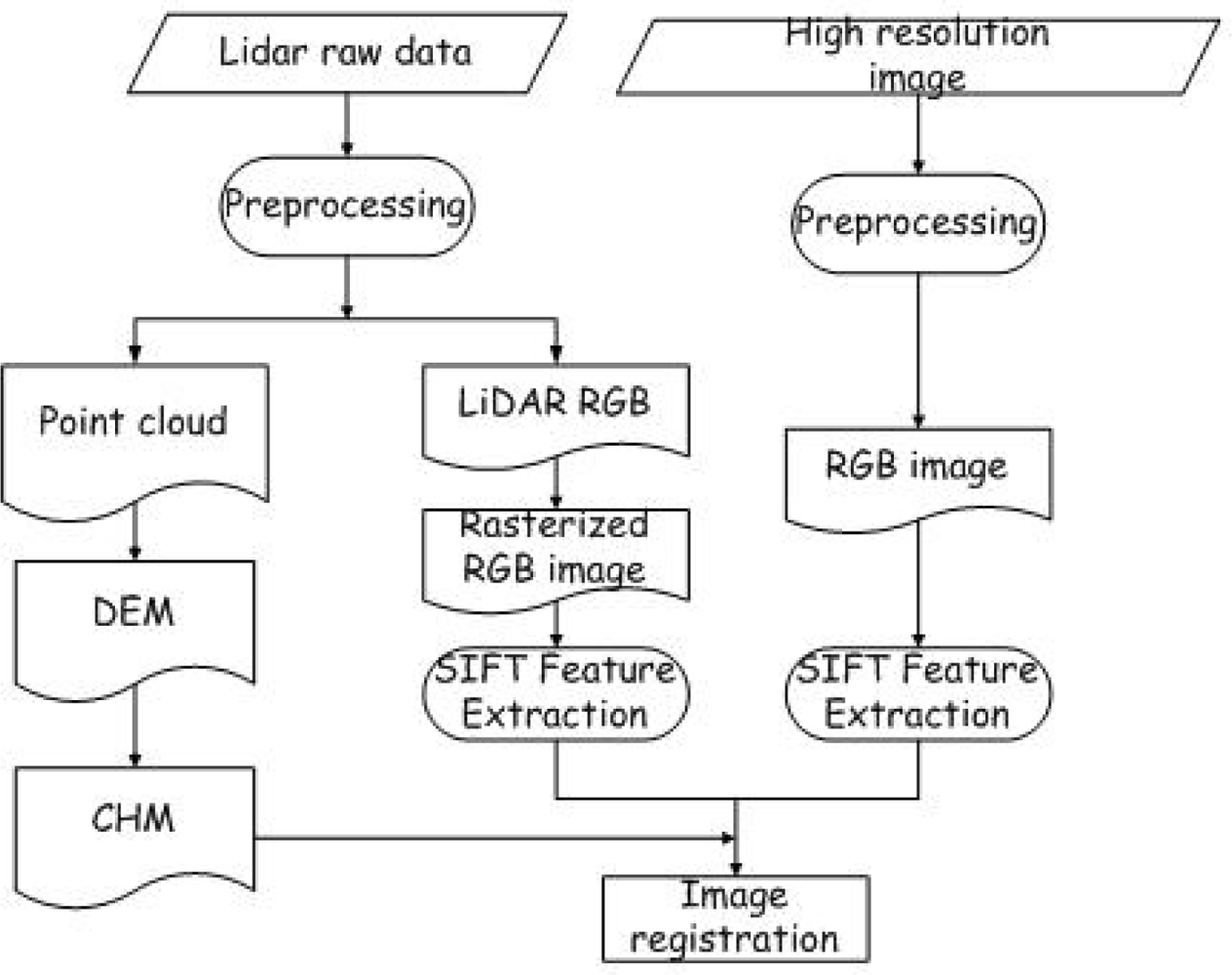
Section 2 outlines the study area, LiDAR data specification, high resolution aerial image characteristics and field data. In Section 3, we introduce methods used for automatic DEM generation, registration and tree structural parameter extraction. The results are presented and discussed in Sections 4 and 5, respectively. Finally, some conclusions are drawn in Section 6.
4. Results
Figure 3 shows the initial DEM after morphological filtering. The LiDAR points above ground have been removed leaving some gaps on the terrain.
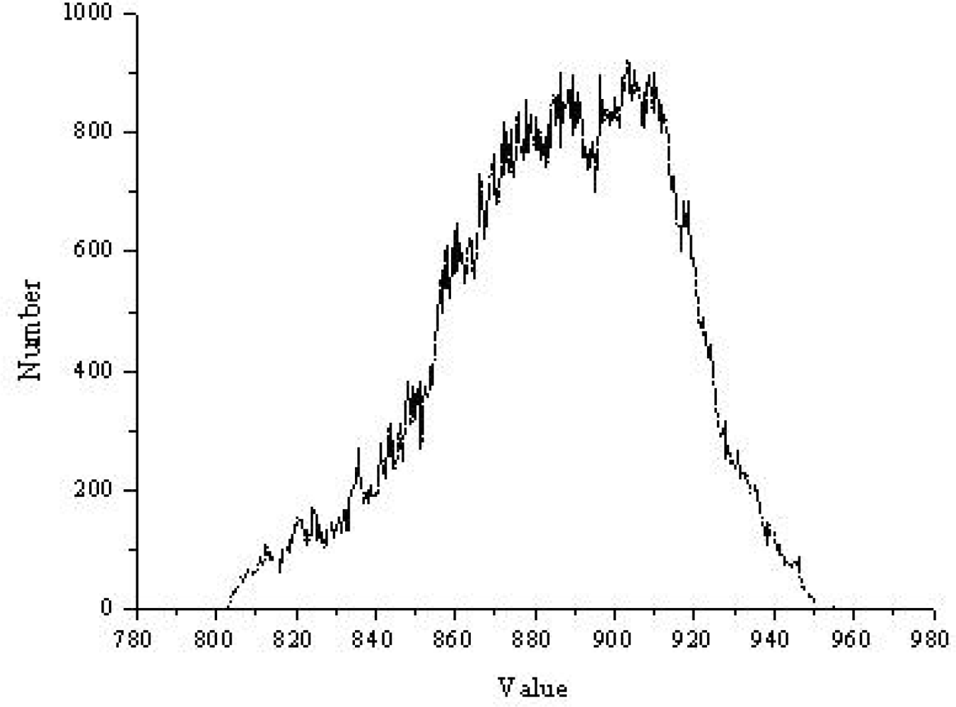
Figure 4 shows the frequency histogram of the initial DEM. As illustrated in
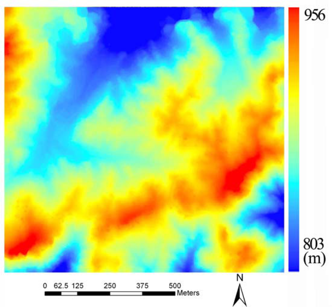
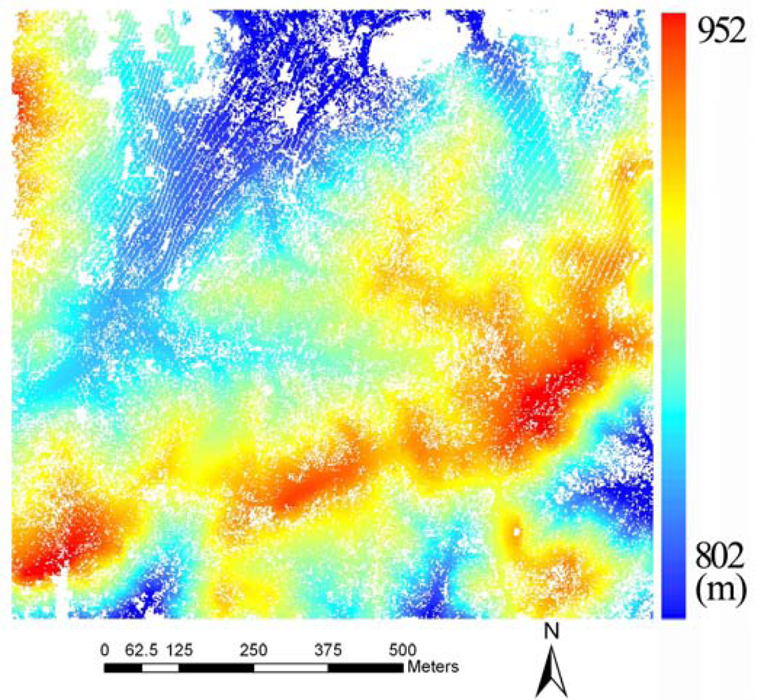
Figure 4, the distribution of the original DEM is approximately normal, so Kriging interpolation was used to generate the final result as illustrated in
Figure 5.
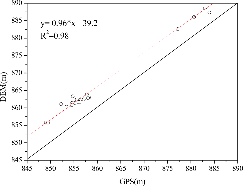
In order to assess the quality of the DEM, several points were measured in the field with high precision GPS. A Pearson’s correlation analysis (R), RMSE and MD (
Equation 2) were performed to calculate the degree of correlation between the GPS measurements and the DEM (
Figure 6):
where
Yj is the estimated measurement and
Yi is the field measurement.
The R squared, RMSE and MD are 0.98, 4.41 and 3.95 m, respectively, and the regression curve is almost parallel to the one to one line. This indicates that the DEM is close to elevation measured by GPS but has a systematic error in it.
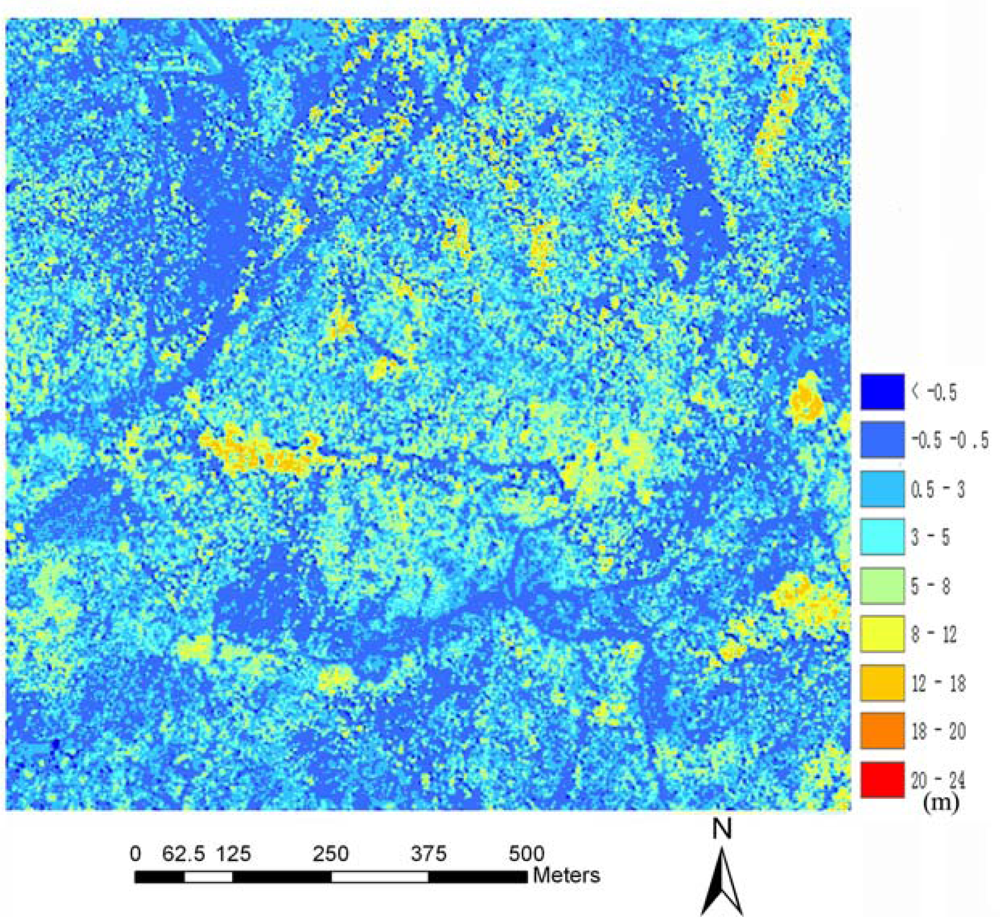
The canopy height model is shown in
Figure 7. As shown as
Figure 7, most points have values from −0.5 to 0.5 m. Greater values were colored by yellow and red, which indicate trees in the CHM.
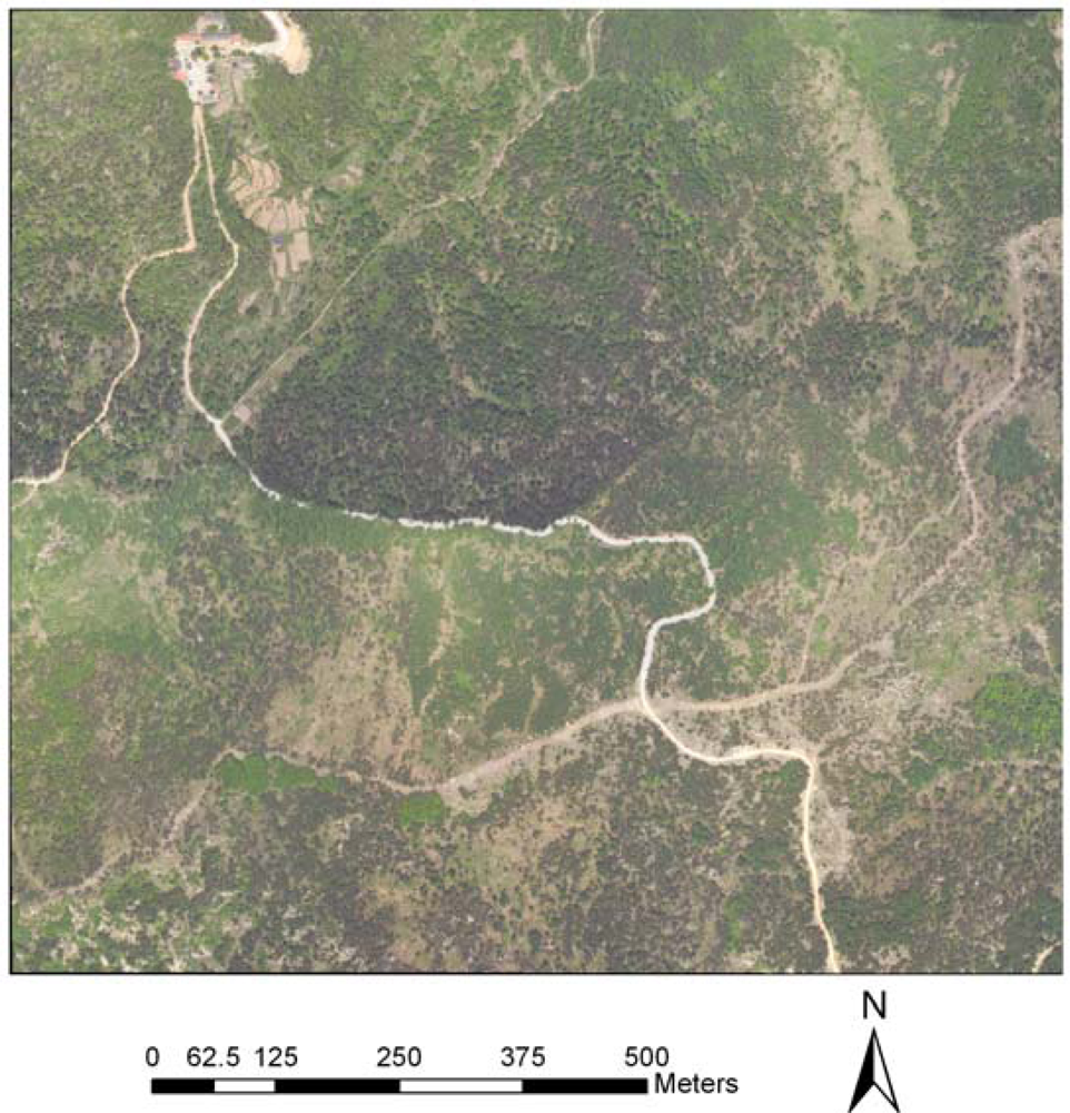
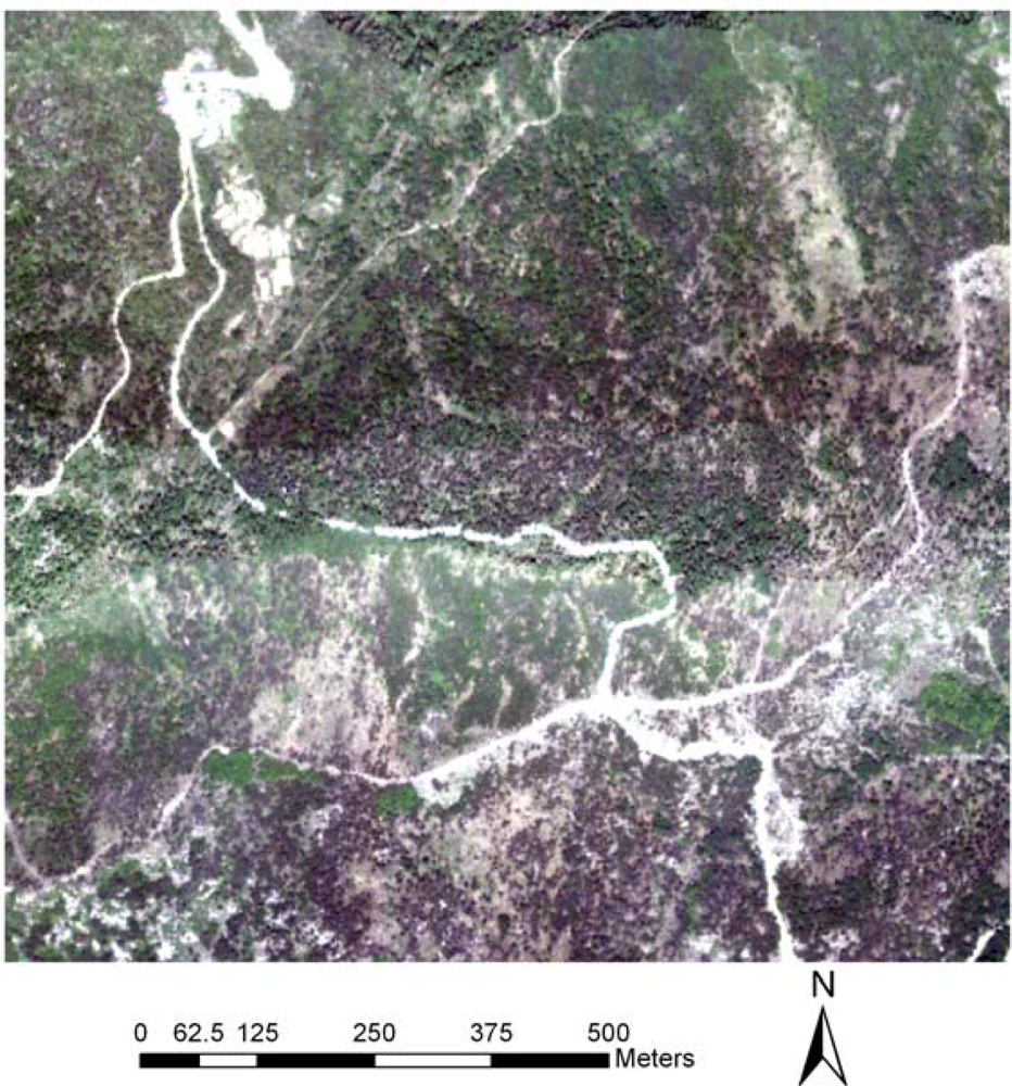
Figures 8 and
9 show high resolution airborne imagery and true color imagery rasterized from the RGB intensity of LiDAR returns, respectively. 141 pairs of control points were selected using the SIFT algorithm and a cubic polynomial was used to match the rasterized RGB to the high resolution airborne imagery.
Figures 10 and
11 show their relative positions before registration and after registration, respectively. As shown in
Figure 11, we can see that roads connect after registration. In order to assess the match accuracy, 20 points was selected randomly, and the RMSE computed from the points is 0.47 pixels, indicating a good match.
Figure 12 shows location of treetops using the local maximum filter and trees are paired by visual analysis. Tree positions measured in the field were compared to the results obtained from the CHM using local maximum filtering and from the aerial image using object-oriented segmentation. Each GPS measured tree was paired with a corresponding treetop when a GPS measured tree location was within the coverage of a crown diameter estimated by watershed segmentation from the CHM or object-oriented segmentation from the aerial image. Errors of omission were recorded when a field-measured tree could not be successfully paired with a tree identified from the CHM or the aerial image. Errors of commission were not recorded because not all of the trees were measured in the field [
22].
Table 2 presents omission errors for broadleaf and conifer trees identified from the CHM and aerial image. As listed in
Table 2, omission errors from the CHM are greater than those from the aerial image for both broadleaf and conifer trees. Omission errors from the CHM have a greater difference between the two species (57.14% for broadleaf trees and 75% for conifer trees) than those from the aerial image (45.71% for broad leaf trees and 51.78% for conifer trees). As a whole, broadleaf trees could be identified better than conifer trees with both methods.
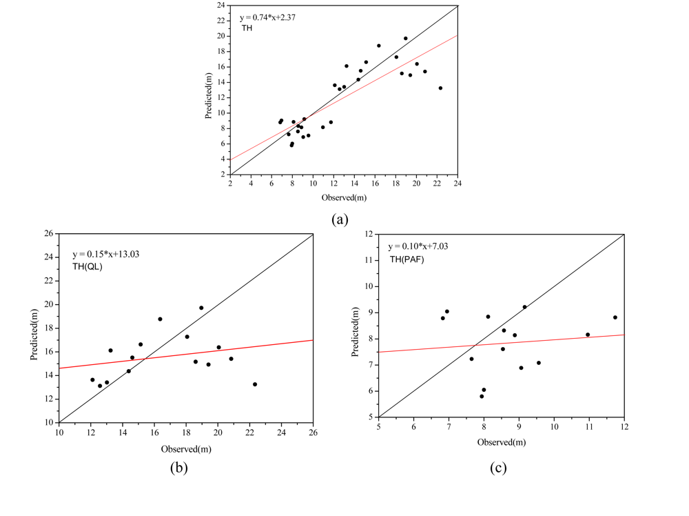
Pearson’s correlation (R), RMSE and MD analysis between measured tree height and predicted tree height is illustrated in
Table 3 and
Figure 13. In order to analyze tree height extraction of different species, tree height statistics for both broadleaf and conifer trees are illustrated. As shown in
Table 3 and
Figure 13, tree heights for conifers and broadleaves are in distinct categories, which contribute to a high correlation when the trees are combined. The R coefficient, RMSE and MD are 0.83, 2.78 and −0.97 m, respectively, though most predicted values are lower than measured values (−0.97 m). As for individual species, tree heights of conifer trees have a smaller RMSE and MD (1.81 m and −0.85 m) than those of broadleaf trees (3.45 m and −1.07 m). However, the correlation between measured and predicted tree heights of broadleaf is greater than that of conifer trees (0.26 for broadleaf trees and 0.12 for conifer trees).
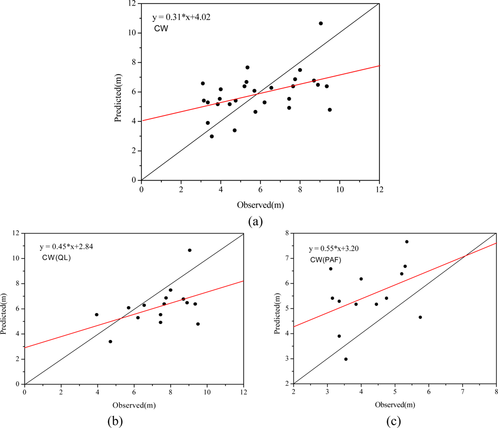
Goodness-of-fit statistics and scatter plots between measured and predicted crown width from the CHM for broadleaf, conifer and combined trees are shown in
Table 4 and
Figure 14, respectively.
As listed in
Table 4, the R coefficient, RMSE and MD are 0.46, 1.88 m and −0.01 m, respectively, for combined species. Goodness-of-fit statistics of broadleaf and conifer are compared in
Table 4. The two species have similar correlation, 0.47 for broadleaf trees and 0.43 for conifer trees. Crown widths of conifer trees have a smaller RMSE (1.71 m) than those of broadleaf trees (2.02 m). As the results in
Table 4 show, most extracted crown widths of broadleaf trees were less than observed crown widths (MD is −1.21 m) and those of conifer trees were greater than measured crown widths (MD is 1.26 m). Comparison of
Figure 14 (b) and (c) also shows a similar result.
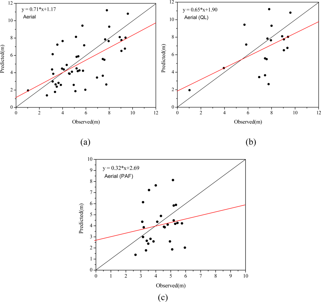
Table 5 and
Figure 15 show statistics and scatter plots of measured crown width and crown width determined from object-oriented segmentation on the high resolution imagery for overall trees, broadleaf and conifer trees. More trees were identified and paired with trees measured in the field, resulting in 19 broadleaf trees and 27 conifer trees matched. The comparison between
Table 4 and
Table 5 shows that the correlation coefficient increases from 0.46 to 0.61 and more points in
Figure 15 are closer to the one to one line. This comparison indicates that higher accuracy of crown width extraction from segmentation of the aerial imagery than from the CHM. As for individual species, correlation between measured and predicted crown widths increases from 0.47 to 0.51 for broadleaf trees, while it decreases from 0.43 to 0.17 for conifer trees. Mean difference is reduced from −1.21 to −0.67 for broadleaf trees and from 1.26 to −0.21 for conifer trees. The two different crown width retrieval methods have divergent results for conifer trees. Predicted crown width from CHM overestimated actual crown width, while those from aerial image underestimated actual crown width.
5. Discussion
Airborne LiDAR data is often used to provide detailed information on tree canopy structure. Lower accuracy was obtained when using low density LiDAR data, as it is difficult to capture crown shape with low density LiDAR data [
22]. As more and more airborne LiDAR systems integrate with CCD cameras, it is highly relevant to assess methods that can combine LiDAR and high resolution imagery for forest structural information extraction. This process is constrained by difficulties in co-registration of airborne LiDAR range data and aerial images. Using the additional RGB intensity included in the LiDAR data, the method proposed here serves as a bridge to match LiDAR range data and high resolution aerial imagery. In this paper, a SIFT algorithm was introduced to automatically find tie points and a cubic polynomial was used to perform registration based on the tie points. The method presented in this paper increased the crown width extraction accuracy when compared with crown width extraction result only based on the CHM, especially for broadleaf trees. More trees were identified and paired with measured trees, and the correlation increases from 0.46 to 0.61. More and more LiDAR systems include intensity information reflected by objects. This intensity could play an important role in co-registration of LiDAR range data and other images. The methods proposed here could also be effective for matching multi-temporal LiDAR data for the purposes of forest growth detection.
The LiDAR point cloud filtering is of primary importance for CHM generation. The morphological filtering algorithm used in this paper achieved mixed results when compared to field estimated values. While the extracted heights seemed to underestimate the field observed values (especially for broadleaf trees), it is just as valid to assume that the field observations over-estimated tree heights. As field estimation of tree heights can be difficult and notoriously inaccurate, we feel it is prudent to exercise caution in using field observed values as “ground truth.” Our results indicate disagreement between LiDAR extracted heights and field estimated heights, but it is difficult to determine which data set is more accurate. It may be possible to increase the accuracy of LiDAR height extraction by incorporating additional information to the automatic filtering algorithm. The filter could be more adaptive by incorporating intensity and contextual information from aerial images and LiDAR point cloud data. Another way to increase accuracy of the LiDAR based tree height extraction is to increase the sampling frequency of the LiDAR. A greater number of LiDAR returns per unit area would result in a denser LiDAR point cloud from which a more accurate CHM can be interpolated.
Although we have demonstrated that combining high resolution aerial imagery with LiDAR can make up for some of the limitations of a low density LiDAR point cloud, both crown widths from CHM and aerial image were poorly correlated with field measured crown widths. Low density of data is one potential source of error, while tree density, models of crown shape, and surface generation also affect accuracy. We estimated the average tree spacing in the study area at about 6 meters. In higher density forests, it is possible that this method would have higher error. The methods we describe (watershed segmentation for CHMs and object-oriented segmentation for aerial imagery) are more effective for dominant tree detection than co-dominant and suppressed trees. Additional research is needed to explore more effective crown width and tree height extraction methods, especially for clustered and/or suppressed trees. There is also a need to establish the relationship between LiDAR point cloud density and the accuracy of extracted forest structural parameters.


