Observation of a Large Landslide on La Reunion Island Using Differential Sar Interferometry (JERS and Radarsat) and Correlation of Optical (Spot5 and Aerial) Images

Abstract
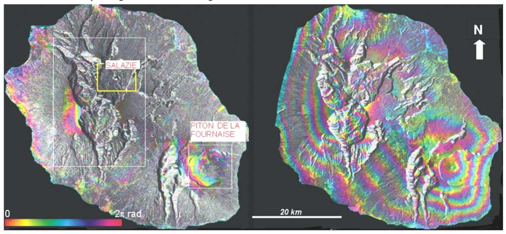
:1. Introduction
2. Differential Radar Interferometry (DInSAR)
2.1. Principle
2.2. Data set
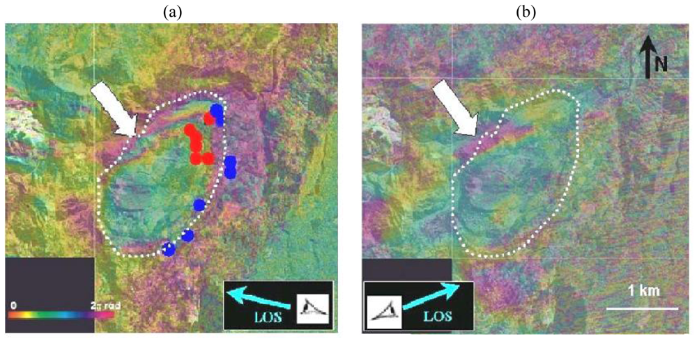
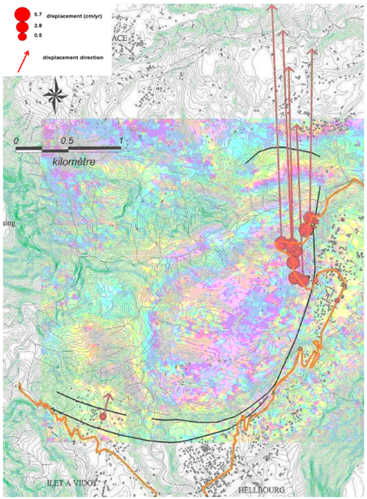
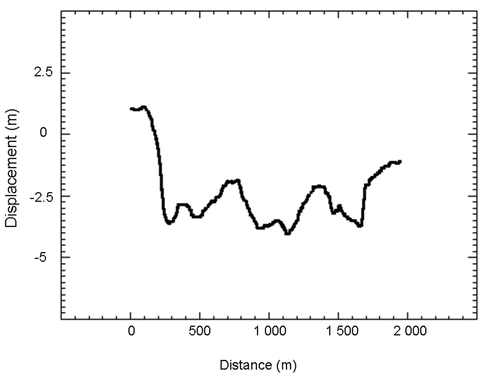
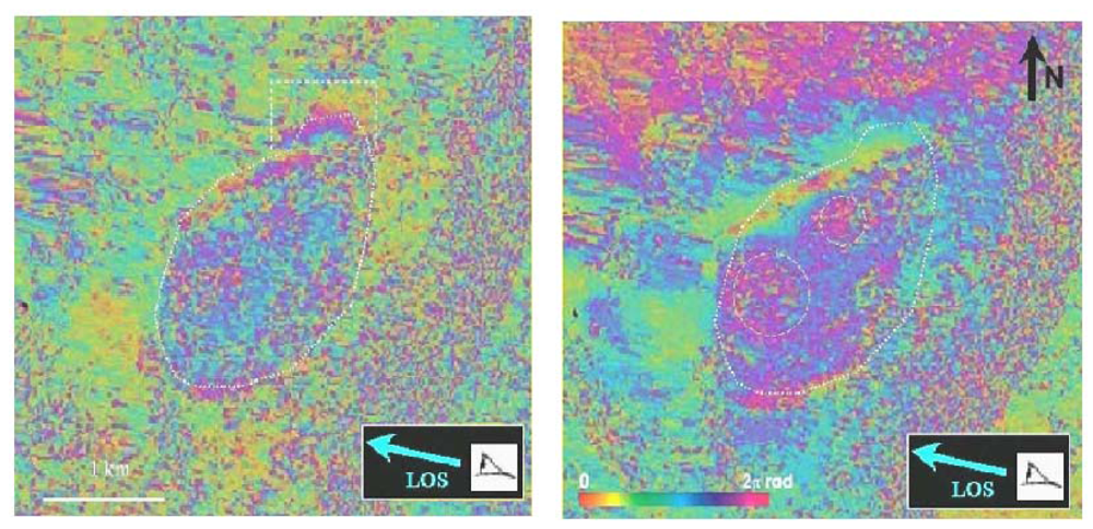
4. Results
4. Optical image correlation
4.1. Methodology and data used
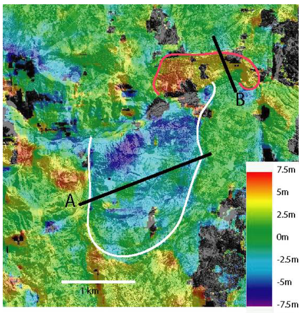
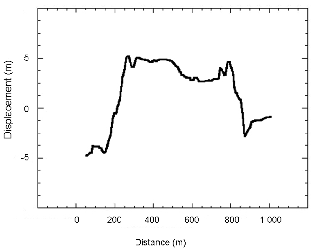
4.2. Results
5. Discussion and Conclusions
Acknowledgments
References and Notes
- Restrepo, C.; Álvarez, N. Landslides and their contribution to land-cover in the mountains of Mexico and Central America. Biotropica 2006, 38, 446–457. [Google Scholar]
- Chazdon, R.L. Tropical forest recovery: legacies of human impact and natural disturbances. Perspectives. Plant Ecol. Evolution. Syst. 2003, 6, 51–71. [Google Scholar]
- Dai, F.C.; Lee, C.F.; Ngai, Y.Y. Landslide risk assessment and management: an overview. Engineering Geology. 2002, 64, 65–87. [Google Scholar]
- Cruchet, M. Approche des problèmes de stabilité des pentes à la Réunion. In Rapport BRGM/RR-37962-FR; 1994; p. 57. [Google Scholar]
- Faye, J.; Lakhdar, Y. Mouvements de Terrains. In Dossier d'information du Ministère de l'Aménagement du Territoire et de l'Environnement; 2000; p. 50. [Google Scholar]
- Cruchet, M. Suivi des déformations au cours de l'année 1999, route de Hellbourg Cirque de Salazie, Ile de La réunion. In Rapport BRGM/RP–50112–FR; 2000; p. 22. [Google Scholar]
- Angeli, M.C.; Pasuto, A.; Silvano, S. A critical review of landslide monitoring experiences. Eng. Geol. 2000, 55, 133–147. [Google Scholar]
- Jackson, M.E.; Bodin, P.W.; Savage, W.Z.; Nel, E.M. Measurement of local horizontal velocities on the Slumgullion landslide using the Global Positioning System. U.S. Geol. Surv. Bull. 1996, 2130, 93–95. [Google Scholar]
- Malet, J.P.; Maquaire, O.; Calais, E. The use of Global Positioning System techniques for the continuous monitoring of landslides. Geomorphology 2002, 43, 33–54. [Google Scholar]
- Squarzoni, C.; Delacourt, C.; Allemand, P. Differential single-frequency GPS monitoring of the La Valette landslide (French Alps). Eng. Geol. 2005, 79, 215–229. [Google Scholar]
- Fruneau, B.; Achache, J.; Delacourt, C. Observation and modelling of the Saint-Etienne-de-Tinée landslide using SAR interferometry. Tectonophysics 1996, 265, 181–190. [Google Scholar]
- Carnec, C.; Massonnet, D.; King, C. Two examples of the use of SAR interferometry on displacement fields of small spatial extension. Geophys. Res. Lett. 1996, 23, 3579–3582. [Google Scholar]
- Squarzoni, C.; Delacourt, C.; Allemand, P. Nine years of spatial and temporal evolution of the “La Valette” landslide observed by SAR interferometry. Eng. Geol. 2003, 68, 53–66. [Google Scholar]
- Strozzi, T.; Wegmuller, U.; Werner, C.; Wiessmann, A.; Spreckels, V. JERS SAR interferometry for land subsidence monitoring. IEEE. Trans. Geosci. Remote Sens. 2003, 41, 1702–1707. [Google Scholar]
- Käab, A.; Huggel, C.; Fischer, L.; Gue, S.; Paul, F.; Roer, I.; Salzmann, N. Remote sensing of glacier- and permafrost-related hazards in high mountains: An overview. Nat. Haz. Earth Syst. Sci. 2005, 5, 527–554. [Google Scholar]
- Delacourt, C.; Allemand, P.; Casson, B.; Vadon, H. Velocity field of the “La Clapière” landslide measured by the correlation of aerial and QuickBird images. Geophys. Res. Lett. 2004, 31, 15. [Google Scholar]
- Delacourt, C.; Allemand, P.; Berthier, E.; Raucoules, D.; Casson, B.; Grandjean, P.; Pambrun, C.; Varrel, E. Remote-sensing techniques for analysing landslide kinematics: a review. Bull.Soc. Géolog. France 2007, 178(2), 89–100. [Google Scholar]
- Casson, B.; Delacourt, C.; Allemand, P. Contribution of multi-temporal remote sensing images to characterize landslide slip surface – Application to the La Clapière landslide (France). Nat. Haz. Earth Syst. Sci. 2005, 5, 425–437. [Google Scholar]
- De Michele, M.; Raucoules, D.; Aochi, H.; Baghdadi, N.; Carnec, C. Measuring coseismic deformation on the northern segment of the Bam Baravat escarpment associated with the 2003 Bam (Iran) earthquake, by correlation of very-high-resolution satellite imagery. Geophys. J. Int. 2008, 173, 459–464. [Google Scholar]
- Zebker, H.A.; Villasenor, J. Decorrelation in interferometric radar echoes. IEEE. Trans. Geosci. Remote Sens. 1992, 30, 950–959. [Google Scholar]
- Massonnet, D.; Feigl, K. Radar interferometry and its application to changes in the earth's surface. Rev. Geophys. 1998, 4, 441–500. [Google Scholar]
- Massonnet, D.; Rossi, M.; Carmona, C.; Adragna, F.; Peltzer, G.; Feigl, K.; Rabaute, T. The displacement field of the Landers earthquake mapped by radar interferometry. Nature 1993, 364, 138–142. [Google Scholar]
- Goldstein, R.M.; Werner, C.L. Radar Interferogram filtering for geophysical applications. Geophys. Res. Lett. 1998, 25, 4035–4038. [Google Scholar]
- Massonnet, D.; Briole, P.; Arnaud, A. Deflation of Mount Etna monitored by spaceborn radar interferometry. Nature 1995, 375, 567–570. [Google Scholar]
- Carnec, C.; Delacourt, C. Three years of mining subsidence monitored by SAR Interferometry, near Gardanne, France. Appl. Geophys. 2000, 43(1), 43–54. [Google Scholar]
- Raucoules, D.; Colesanti, C.; Carnec, C. Use of SAR interferometry for detecting and assessing ground subsidence. Compt. Rend. Geosci. 2007, 339, 289–302. [Google Scholar]
- Williams, S.; Bock, Y.; Fang, P. Integrated satellite interferometry: tropospheric noise, GPS estimates and implications for interferometric synthethic aperture products. J. Geophys. Res. 1998, 103, 27051–27067. [Google Scholar]
- Tarayre, H.; Massonnet, D. Atmospheric propagation heterogeneities revealed by ERS-1 interferometry. Geophys. Res. Lett. 1998, 23, 989–992. [Google Scholar]
- Delacourt, C.; Briole, P.; Achache, J. Tropospheric corrections of SAR interferograms with strong topography: Application to Etna. Geophys. Res. Letters. 1998, 25, 2849–2852. [Google Scholar]
- Strozzi, T.; Kääb, A.; Frauenfelder, R.; Wegmüller, U. Detection and Monitoring of Unstable High-Mountain Slopes with L-Band SAR Interferometry. IGARSS'03, Toulouse, France, July 21-25, 2003.
- Nagler, T.; Mayer, C.; Rott, H. Feasibility of DINSAR for mapping complex motion fields of Alpine ice and rock glaciers. Proceedings of 3rd International Symposium on Retrieval of Bio- and Geophysical Parameters from SAR Data for Land Applications, Sheffield, UK, September 11-14, 2001; Wilson, A., Ed.; Publications Division: Noordwijk, Netherlands, 2002; pp. 377–382. [Google Scholar]
- Werner, C.L.; Wegmuller, U.; Strozzi, T.; Wiesmann, A. GAMMA SAR and interferometric processing software. Proceedings of the ERS-ENVISAT Symposium (European Space Agency Special Publication ESA SP-461, Gothenburg, Sweden, October 16-20, 2000.
- Raucoules, D.; Maisons, C.; Carnec, C.; Le Mouélic, S.; King, C.; Hosford, S. Monitoring of slow ground deformation by ERS radar interferometry - The case of Vauvert (France). Remote Sens. Environ. 2003, 88, 468–478. [Google Scholar]
- Durand, P.; Sigmundsson, F.; Massonnet, D. Opening of the March 1998 eruptive fissure at Piton de la Fournaise volcano measured by RADARSAT satellite radar interferometry. EOS Transactions American Geophysical Union, 79, AGU Fall Meeting Abstracts; 1998; p. F35. [Google Scholar]
- Vadon, H.; Massonnet, D. Earthquake displacement fields mapped by very precise correlation. Complementarity with radar interferometry. IGARSS proc, New York, USA, July 2002.
- Van Puymbroeck, N.; Michel, R.; Binet, R.; Avouac, J.P.; Taboury, J. Measuring earthquakes from optical satellite images. Appl. Optic. 2000, 39, 3486–3494. [Google Scholar]
- Michel, R.; Avouac, J.P. Deformation due to the 17 August 1999 Izmit, Turkey, earthquake measured from SPOT images. J. Geophys. Res. 2002, 107, 2062. [Google Scholar]
- Binet, R.; Bollinger, L. Horizontal coseismic deformation of the 2003 Bam (Iran) earthquake measured from SPOT-5 THR satellite imagery. Geophys. Res. Lett. 2005, 32, L02307. [Google Scholar]
- Kaab, A. Monitoring high-mountain terrain deformation from repeated air- and spaceborne optical data: examples using digital aerial imagery and ASTER data. ISPRS J. Photogram. Remote Sens. 2002, 57, 39–52. [Google Scholar]
- Berthier, E.; Vadon, H.; Baratoux, D.; Arnaud, Y.; Vincent, C.; Feigl, K.L.; Rémy, F.; Legrésy, B. Mountain glaciers surface motion derived from satellite optical imagery. Remote Sens. Environ. 2005, 95, 14–28. [Google Scholar]
- de Michele, M.; Briole, P. Deformation between 1989 and 1997 at Piton de la Fournaise volcano retrieved from correlation of panchromatic airborne images. Geophys. J. Int. 2007, 169, 357–364. [Google Scholar]
- Vadon, H.; Massonnet, P. Earthquake displacement fields mapped by very precise correlation. Complementarity with radar interferometry. IGARSS Proc., New Jersey; 2002; pp. 2700–2702. [Google Scholar]


| Date | Orbit | 16850 | 18908 | 19594 | 21652 | 21995 | 22338 | 23710 | 24053 | 25768 | 26797 | 28855 | 29198 | 29884 | 31599 | 32285 |
|---|---|---|---|---|---|---|---|---|---|---|---|---|---|---|---|---|
| Orbit | ||||||||||||||||
| 26/01/1999 | 16850 | 225 | ||||||||||||||
| 13/07/1999 | 18908 | |||||||||||||||
| 06/08/1999 | 19594 | 85 | 235 | |||||||||||||
| 28/12/1999 | 21652 | 190 | ||||||||||||||
| 21/01/2000 | 21995 | 168 | 115 | 82 | ||||||||||||
| 14/02/2000 | 22338 | 48 | ||||||||||||||
| 20/05/2000 | 23710 | |||||||||||||||
| 13/06/2000 | 24053 | 360 | 260 | |||||||||||||
| 11/10/2000 | 25768 | 280 | ||||||||||||||
| 22/12/2000 | 26797 | 696 | 192 | |||||||||||||
| 15/05/2001 | 28855 | 648 | 68 | |||||||||||||
| 08/06/2001 | 29198 | 480 | 360 | 35 | ||||||||||||
| 26/07/2001 | 29884 | 528 | 48 | |||||||||||||
| 23/11/2001 | 31599 | 192 | ||||||||||||||
| 10/01/2002 | 32285 | 440 |
| Date | 02/01/1997 | 15/02/1997 | 31/03/1997 | 14/05/1997 | 27/06/1997 | 10/08/1997 |
|---|---|---|---|---|---|---|
| 02/01/1997 | 44 | 88 | 132 | |||
| 15/02/1997 | 153 | 44 | 88 | |||
| 31/03/1997 | 111 | 70 | 44 | |||
| 14/05/1997 | 187 | 99 | 90 | |||
| 27/06/1997 | 44 | |||||
| 10/08/1997 | 920 |
© 2009 by the authors; licensee Molecular Diversity Preservation International, Basel, Switzerland. This article is an open access article distributed under the terms and conditions of the Creative Commons Attribution license (http://creativecommons.org/licenses/by/3.0/).
Share and Cite
Delacourt, C.; Raucoules, D.; Le Mouélic, S.; Carnec, C.; Feurer, D.; Allemand, P.; Cruchet, M. Observation of a Large Landslide on La Reunion Island Using Differential Sar Interferometry (JERS and Radarsat) and Correlation of Optical (Spot5 and Aerial) Images. Sensors 2009, 9, 616-630. https://doi.org/10.3390/s90100616
Delacourt C, Raucoules D, Le Mouélic S, Carnec C, Feurer D, Allemand P, Cruchet M. Observation of a Large Landslide on La Reunion Island Using Differential Sar Interferometry (JERS and Radarsat) and Correlation of Optical (Spot5 and Aerial) Images. Sensors. 2009; 9(1):616-630. https://doi.org/10.3390/s90100616
Chicago/Turabian StyleDelacourt, Christophe, Daniel Raucoules, Stéphane Le Mouélic, Claudie Carnec, Denis Feurer, Pascal Allemand, and Marc Cruchet. 2009. "Observation of a Large Landslide on La Reunion Island Using Differential Sar Interferometry (JERS and Radarsat) and Correlation of Optical (Spot5 and Aerial) Images" Sensors 9, no. 1: 616-630. https://doi.org/10.3390/s90100616