Using ASTER Imagery in Land Use/cover Classification of Eastern Mediterranean Landscapes According to CORINE Land Cover Project

Abstract
:1. Introduction
2. Material and Methods
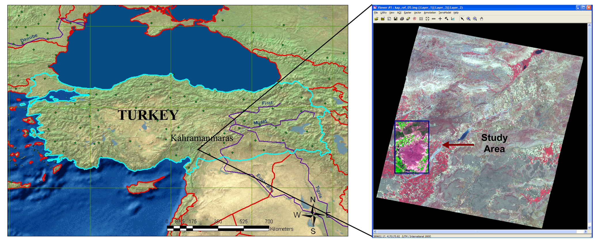
2.1 Study Area
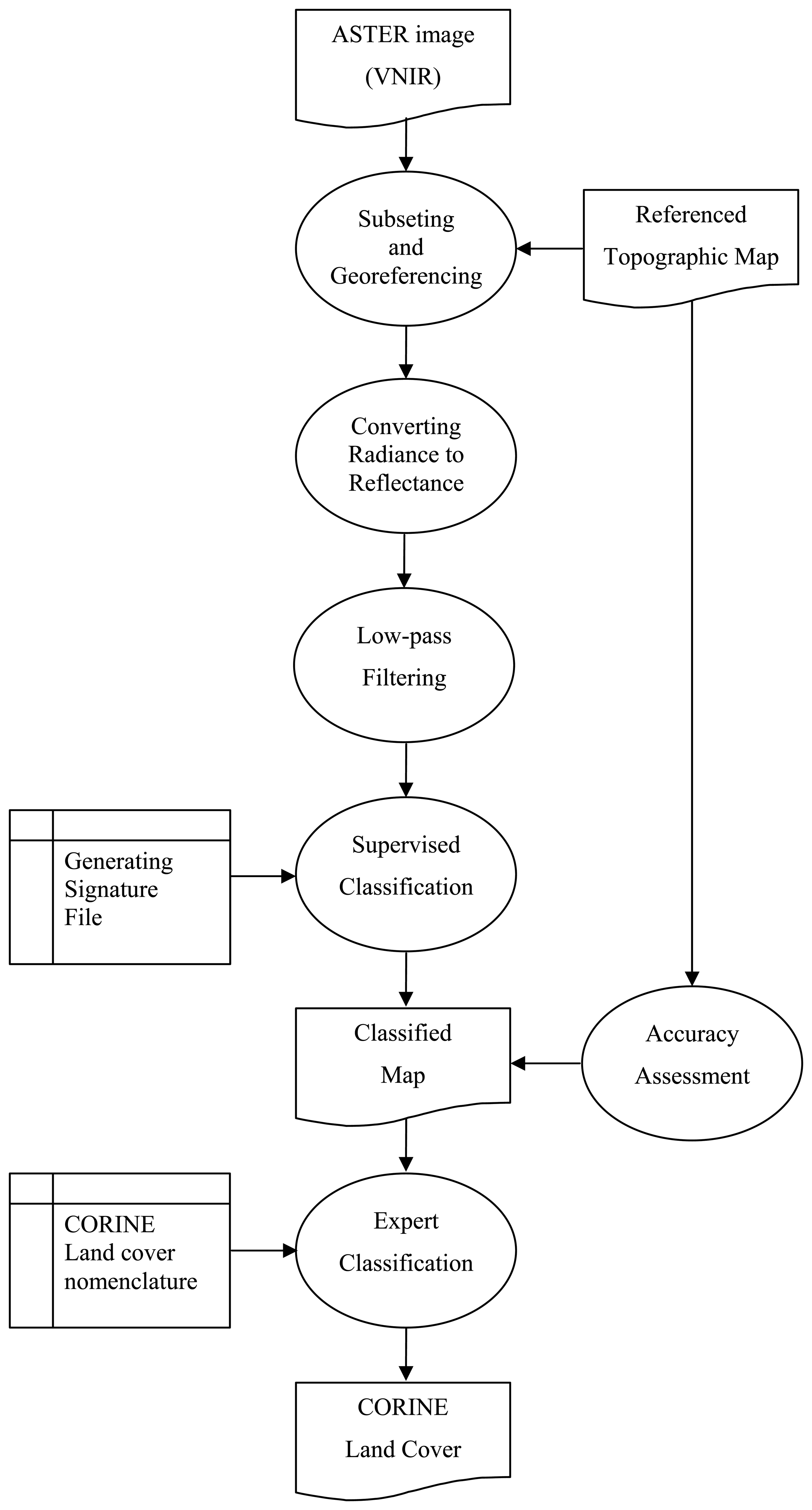
2.2. Image Processing
2.2.1. Preprocessing
2.2.2. Converting ASTER Radiance Values to Reflectance
2.2.3. Land use/cover classification
2.2.4. Expert Classification
3. Results and Discussion
3.1. Converting ASTER Radiance Values to Reflectance
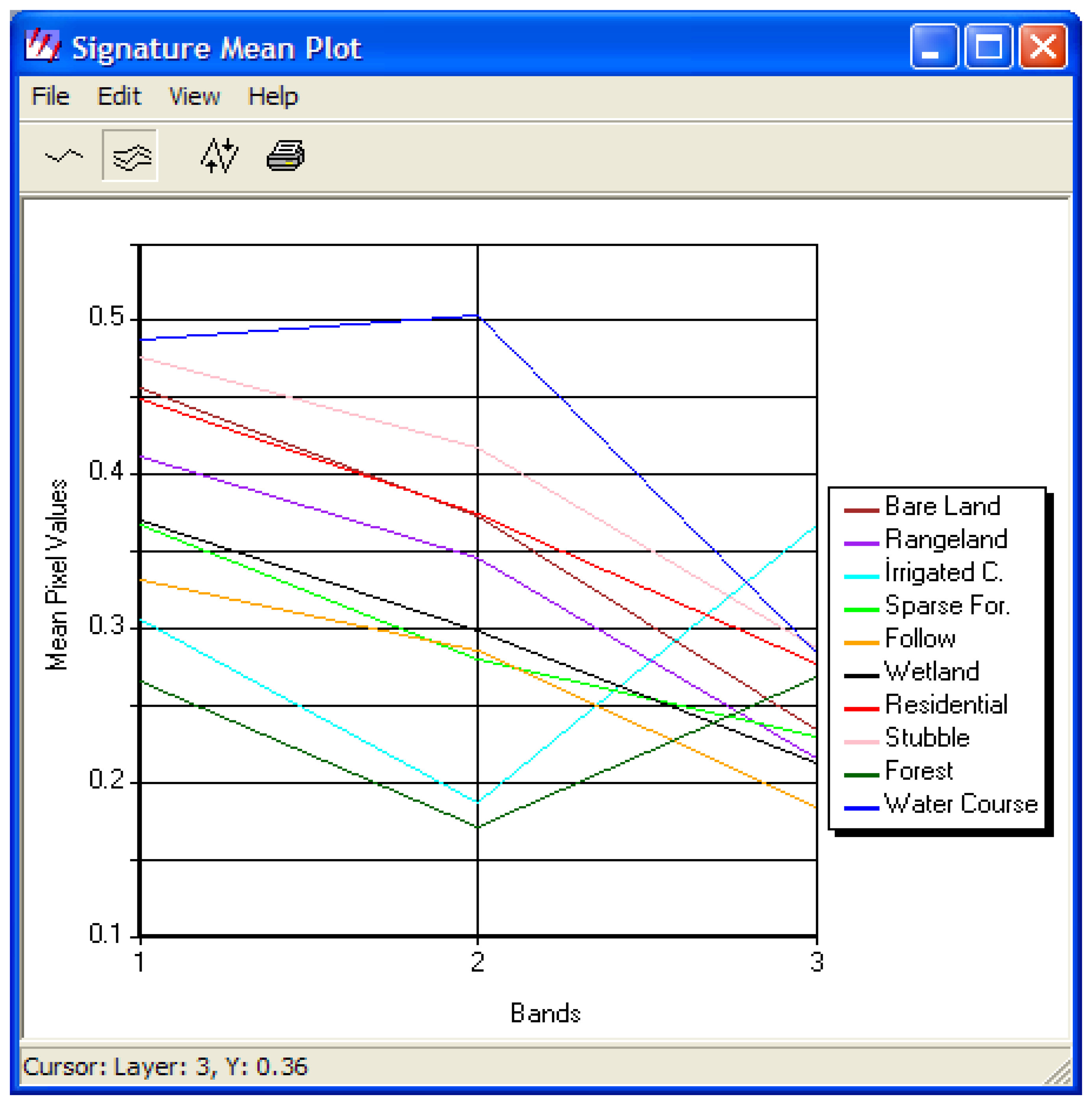
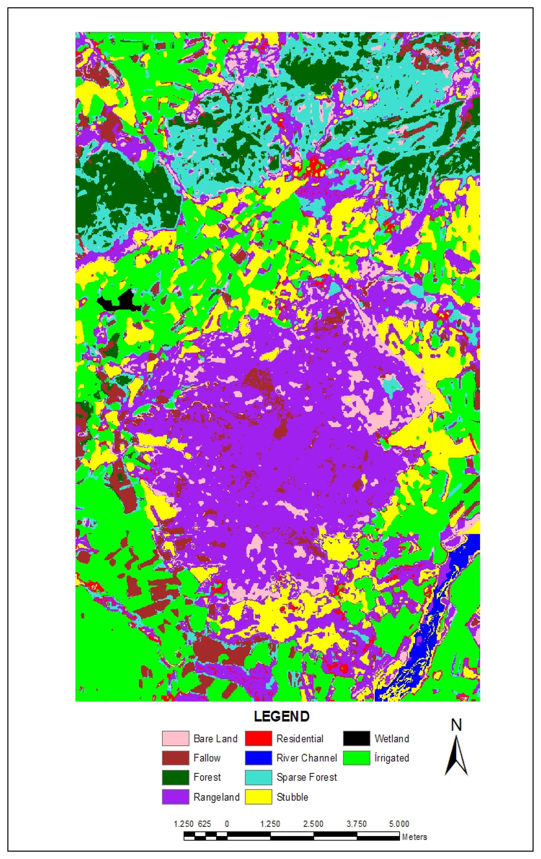
3.2. Land use/cover classification
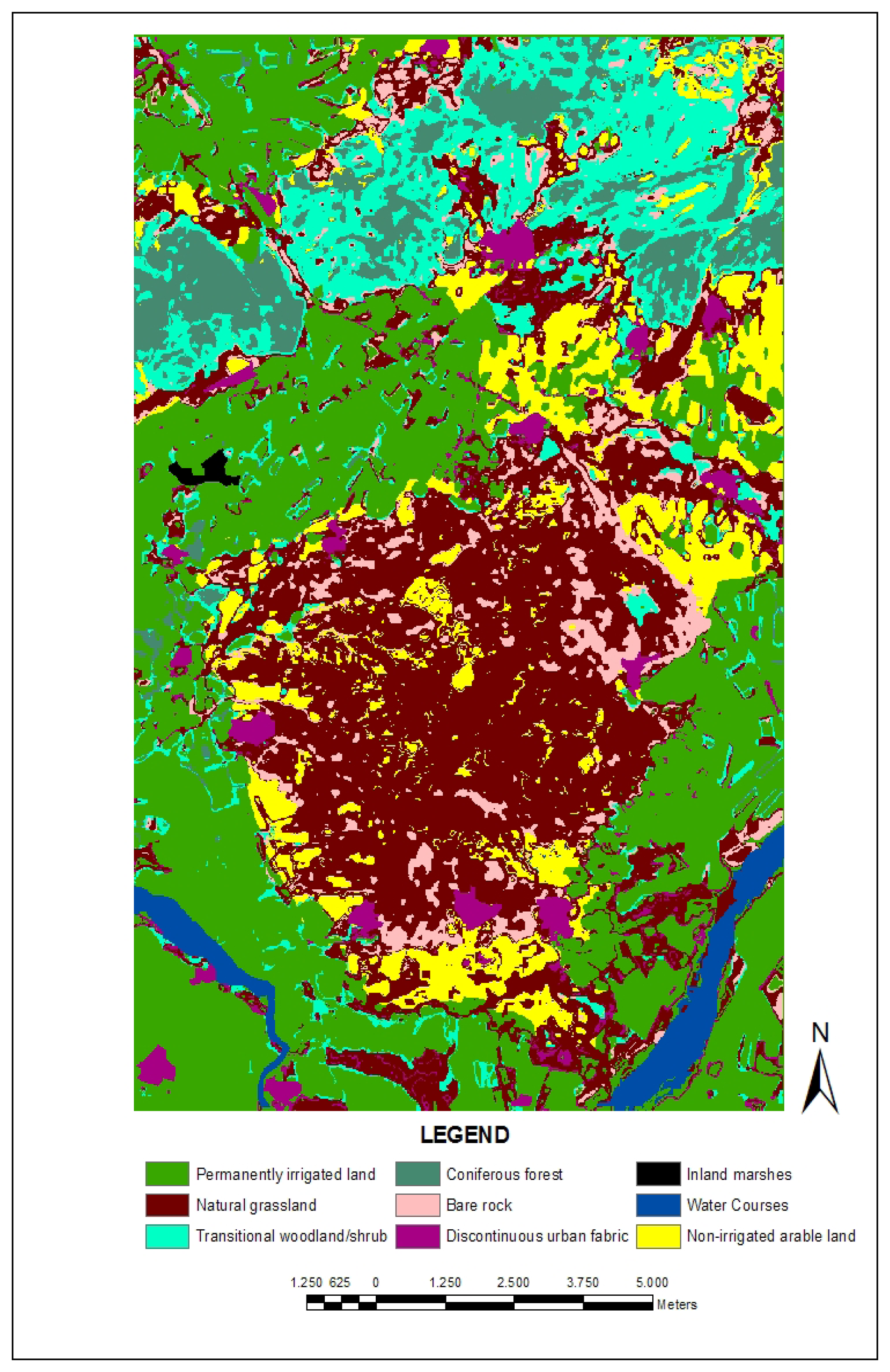
3.3. Expert Classification
4. Conclusions
Acknowledgments
References
- Alrababah, M.A.; Alhamad, M.N. Land use/cover classification of arid and semi-arid Mediterranean landscapes using Landsat ETM. International Journal of Remote Sensing 2006, 27, 2703–2718. [Google Scholar]
- Vogelmann, J.E.; Helderb, D.; Morfitta, R.; Choatea, M. J.; Merchantc, J.W.; Bulley, H. Effects of Landsat 5 Thematic Mapper and Landsat 7 Enhanced Thematic Mapper Plus radiometric and geometric calibrations and corrections on landscape characterization. Remote Sensing of Environment 2001, 78, 55–70. [Google Scholar]
- Berberoglu, S.; Lloyd, C.D.; Atkinson, P.M.; Curran, P.J. The integration of spectral and textural information using neural networks for land cover mapping in the Mediterranean. Computers and Geosciences 2000, 26, 385–396. [Google Scholar]
- Calvao, T.; Palmeirim, J.M. Mapping Mediterranean scrub with satellite imagery: Biomass estimation and spectral behaviour. International Journal of Remote Sensing 2004, 25, 3113–3126. [Google Scholar]
- Koutsias, N.; Karteris, M. Classification analyses of vegetation for delineating forest fire fuel complexes in a Mediterranean test site using satellite remote sensing and GIS. International Journal of Remote Sensing 2003, 24, 3093–3104. [Google Scholar]
- Lobo, A.; Legendre, P.; Rebollar, J.L.G.; Carreras, J.; Ninot, J.M. Land cover classification at a regional scale in Iberia: Separability in a multi-temporal and multi-spectral data set of satellite images. International Journal of Remote Sensing 2004, 25(1), 205–213. [Google Scholar]
- Hirataa, M.; Kogab, N.; Shinjoc, H.; Fujitad, H.; Gintzburger, G.; Miyazaki, A. Vegetation classification by satellite image processing in a dry area of northeastern Syria. International Journal of Remote Sensing 2001, 22, 507–516. [Google Scholar]
- Vieira, I.G.C.; De Almeida, A.S.; Davidson, E.A.; Stone, T.A.; De Ccarvalho, C.J.R.; Guerrero, J.B. Classifying successional forests using Landsat spectral properties and ecological characteristics in eastern Amazonia. Remote Sensing of Environment 2003, 87, 470–481. [Google Scholar]
- Zheng, D.; Rademacher, J.; Chen, J.; Crow, T.; Bresee, M.; Moine, J.L.; Ryu, S.-R. Estimating aboveground biomass using Landsat 7 ETM+ data across a managed landscape in northern Wisconsin, USA. Remote Sensing of Environment 2004, 93, 402–411. [Google Scholar]
- Anderson, A.B.; Wang, G.; Gertner, G. Local variability based sampling for mapping a soil erosion cover factor by co-simulation with Landsat TM images. International Journal of Remote Sensing 2006, 27, 2423–2447. [Google Scholar]
- Shi, P.J.; Yuan, Y.; Zheng, J.; Wang, J.A.; Ge, Y.; Qiu, G.Y. The effect of land use/cover change on surface runoff in Shenzhen region, China. Catena 2007, 69, 31–35. [Google Scholar]
- De Jong, B.H.J. Land-Use Change and Carbon Flux Between 1970s and 1990s in Central Highlands of Chiapas, Mexico. Environmental Management 1999, 23, 373–385. [Google Scholar]
- Evrendilek, F. Integrating Map Algebra and Statistical Modeling for Spatio-Temporal Analysis of Monthly Mean Daily Incident Photosynthetically Active Radiation (PAR) over a Complex Terrain. Sensors 2007, 7, 3242–3257. [Google Scholar]
- Evrendilek, F.; Berberoglu, S.; Gulbeyaz, O.; Ertekin, C. Modeling Potential Distribution and Carbon Dynamics of Natural Terrestrial Ecosystems: A Case Study of Turkey. Sensors 2007, 7, 2273–2296. [Google Scholar]
- Cohen, W.B.; Goward, S.N. Landsat's role in ecological applications of remote sensing. Bioscience 2004, 54, 535–545. [Google Scholar]
- Musaoglu, N.; Coskun, M.; Kocabas, V. Land use change analysis of Beykoz- Istanbul by means of satellite images and GIS. Water Science and Technology 2005, 51, 245–251. [Google Scholar]
- Benedetti, R.; Rossini, P.; Taddei, R. Vegetation classification in the middle Mediterranean area by satellite data. International Journal of Remote Sensing 1994, 15, 583–596. [Google Scholar]
- Abrams, M. The Advanced Spaceborne Thermal Emission and Reflection Radiometer (ASTER): data products for the high spatial resolution imager on NASA's Terra platform. International Journal of Remote Sensing 2003, 21(5), 847–859. [Google Scholar]
- Rowan, L.C.; Mars, J.C. Lithologic mapping in the Mountain Pass, California area using advanced spaceborne thermal emission and reflection radiometer (ASTER) data. Remote Sensing of Environment 2003, 84, 350–366. [Google Scholar]
- Zhu, G.; Blumberg, D.G. Classification using ASTER data and SVM algorithms; the case study of Beer Sheva, Israel. Remote Sensing of Environment 2001, 80, 233–240. [Google Scholar]
- Davis, F. W.; Simonett, D. S. GIS and remote sensing. In Geographical information systems: principles and applications; Maguire, D.J., Goodchild, M.F., Rhind, D.W., Eds.; Longman Scientific and Technical: London, GB, 1991; pp. 191–213. [Google Scholar]
- Jensen, J.R. Introductory Digital Image Processing: A Remote Sensing Perspective, 3rd Ed. ed; Prentice-Hall: Upper Saddle River, NJ, 2005. [Google Scholar]
- Vermote, E. F.; El Saleous, N.Z.; Justice, C.O. Atmospheric correction of MODIS data in the visible to middle infrared: first results. Remote Sensing of Environment 2002, 83, 97–111. [Google Scholar]
- Song, C.; Woodcock, C.E.; Seto, K.C.; Lenney, M.P.; Macomber, S.A. Classification and Change Detection Using Landsat TM Data: When and How to Correct Atmospheric Effects? Remote Sensing of Environment 2001, 75, 230–244. [Google Scholar]
- Kaufman, Y.J. The atmospheric effect on the separability of field classes measured from satellites. Remote Sensing of Environment 1985, 18, 21–34. [Google Scholar]
- Richter, R. A spatially adaptive fast atmospheric correction algorithm. International Journal of Remote Sensing 1996, 17, 1201–1214. [Google Scholar]
- Teillet, P.M. An algorithm for the radiometric and atmospheric correction of AVHRR data in the solar reflective. Remote Sensing Environment 1991, 41, 185–195. [Google Scholar]
- Falkowski, M.J.; Gessler, P.E.; Morgan, P.; Hudak, A.; Smith, T. Characterizing and mapping forest fire fuels using ASTER imagery and gradient modeling. Forest Ecology and Management 2005, 217, 129–146. [Google Scholar]
- Berberoglu, S.; Evrendilek, F.; Ozkan, C.; Donmez, C. Modeling Forest Productivity Using Envisat MERIS Data. Sensors 2007, 7, 2115–2127. [Google Scholar]
- Xiaoling, C.; Xiaobin, C.; Hui, L. Expert classification method based on patch-based neighborhood searching algorithm. Geo-Spatial Information Science 2006, 10(1), 37–43. [Google Scholar]
- Moller-Jensen, L. Classification of Urban land cover based on expert systems, object models and texture. Computers, Environment and Urban Systems 1997, 21, 291–302. [Google Scholar]
- EEA, CORINE Land Cover. European Environment Agency. Acquired from http://reports.eea.europa.eu/CORO-landcover/en Accessed in January 2008.
- ERDAS/Leica Geosystem. ERDAS Imagine 8.5. Tour Guide; 2001; Atlanta; ERDAS Inc. Geosystem. [Google Scholar]
- Smith, A.M.S. How to Convert ASTER Radiance Values to Reflectance. College of Natural Resources, University Idaho. An Online Guide. Acquired from www.cnrhome.uidaho.edu/default.aspx?pid=85984.
- Abrams, M.; Hook, S. ASTER User Handbook; 1998; Version 1; NASA/Jet Propulsion Laboratory: Pasadena. [Google Scholar]
- Thome, K.; Biggar, S.; Slater, P. Effects of assumed solar spectral irradiance on intercomparisons of earth-observing sensors. In Sensors, Systems, and Next-Generation Satellites; Proceedings of SPIE; December 2001; Fujisada, H., Lurie, J., Weber, K., Eds.; Vol. 4540, pp. 260–269. [Google Scholar]
- Archard, F.; D'Souze, G. Collection and pre-processing of NOAA-AVHRR 1km resolution data for tropical forest resource assessment. In Report EUR 16055 for European Commission; Luxembourg, 1994. [Google Scholar]
- Eva, H.; Lambin, E.F. Burnt area mapping in Central Africa using ATSR data. International Journal of Remote Sensing 1998, 19, 3473–3497. [Google Scholar]
- Jensen, J. R. Remote sensing of the environment: An earth resource perspective; Prentice-Hall: Upper Saddle River, NJ, 2000. [Google Scholar]
- Lillesand, T.M.; Kiefer, R.W. Remote Sensing and Image Interpretation; John Wiley & Sons: New York, NY, 1994; p. 750. [Google Scholar]
- ESRI. ERDAS Imagine 8.5. Field Guide; ESRI Inc.: Atlanta, 2001. [Google Scholar]
- Akay, A.E.; Tutus, A. Using Image Analysis in Estimating Blue Stain Defects on Fire-Killed Brutian Pine (Pinus brutia). Wood Research Journal 2006, 51(1), 41–48. [Google Scholar]
- Stefanov, W.L.; Netzband, M. Assessment of ASTER land cover and MODIS NDVI data at multiple scales for ecological characterization of an arid urban center. Remote Sensing of Environment 2005, 99, 31–43. [Google Scholar]
- Chen, X.; Vierling, L.; Deering, D. A simple and effective radiometric correction method to improve landscape change detection across sensors and across time. Remote Sensing of Environment 2005, 98, 63–79. [Google Scholar]
- Richter, R.; Schlapfer, D.; Muller, A. An automatic atmospheric correction algorithm for visible/NIR imagery. International Journal of Remote Sensing 2006, 26, 2077–2085. [Google Scholar]
- Akay, A.E.; Karas, I.R.; Gundogan, R. Classification of Tree and Shrub Species in KSU Research and Application Forest In Kahramanmaras, Turkey. In Proc. 10th Intl. Symposium on Physical Measurements and Spectral Signatures in Remote Sensing; Schaepman, M., Liang, S., Groot, N., Kneubühler, M., Eds.; Intl. Archives of the Photogrammetry, Remote Sensing and Spatial Information Sciences; Vol. XXXVI, WG VII/I, ISPRS; Davos (CH), ISSN; 2007. [Google Scholar]
- Tapiador, F. J.; Casanova, J.L. Land use mapping methodology using remote sensing for the regional planning directives in Segovia, Spain. Landscape and Urban Planning 2003, 62, 103–115. [Google Scholar]


| Band | Coefficient (W/m2*sr*um)/DN) | *ESUNi | ||
|---|---|---|---|---|
| High Gain | Normal | Low Gain 1 | ||
| 1 | 0.676 | 1.688 | 2.25 | 1847 |
| 2 | 0.708 | 1.415 | 1.89 | 1553 |
| 3N | 0.423 | 0.862 | 1.15 | 1118 |
| 3B | 0.423 | 0.862 | 1.15 | |
| Level 1 | Level 2 | Level 3 |
|---|---|---|
| 1. Artificial surfaces | 1.1. Urban Fabric | 1.1.2. Discontinuous urban fabric |
| 1.2. Industrial, commercial, and transport units | 1.2.2. Road and rail networks and associated land | |
| 2. Agricultural areas | 2.1. Arable land | 2.1.1.Non-irrigated arable land |
| 2.1.2.Permanently irrigated land | ||
| 3. Forests and semi-natural areas | 3.1. Forests | 3.1.2. Coniferous forest |
| 3.2. Shrub and/or herbaceous vegetation association | 3.2.1. Natural grassland | |
| 3.2.4. Transitional woodland/shrub | ||
| 3.3. Open spaces with little or no vegetation | 3.3.2. Bare rock | |
| 4. Wetlands | 4.1. inland wetlands | 4.1. 1. Inland marshes |
| 5. Water bodies | 5.1. Inland waters | 5.1.1. Water courses |
| Classified Land Covers | Reference Land Covers | CORINE Land Covers | |||
|---|---|---|---|---|---|
| Class Values | Class Names | Class Values | Class Names | Class Values | CORINE Nomenclature |
| 1 | Irrigated Crops | 1 | Resident | 1 | Permanently irrigated land |
| 2 | Fallow | 2 | Irrigated | 2 | Natural grassland |
| 3 | Stubble | 3 | Water Course | 3 | Transitional woodland/shrub |
| 4 | Rangeland | 4 | Non-irrigated | 4 | Coniferous forest |
| 5 | Sparse forest | 5 | Bare rock | ||
| 6 | Forest | 6 | Discontinuous urban fabric | ||
| 7 | Bare land | 7 | Inland marshes | ||
| 8 | Residential | 8 | Water Courses | ||
| 9 | Wetland | 9 | Non-irrigated arable land | ||
| 10 | Water Courses | 10 | Road and rail networks and associated land | ||
| Statement Used in ERDAS Spatial Modeler: | |||||
| CONDITIONAL {(Reference = = 1) 6, (Reference = = 3) 8, (Classified = = 1) 1, (Classified = = 4) 2, (Classified = = 5) 3, (Classified = = 6) 4, (Classified = = 7) 5, (Classified = = 8) 6, (Classified = = 9) 7, (Classified = = 10) 8, (Classified = = 2 AND Reference = = 1) 6, (Classified = = 2 AND Reference = = 2) 1, (Classified = = 2 AND Reference = = 3) 8, (Classified = = 2 AND Reference = = 4) 9, (Classified = = 3 AND Reference = = 1) 6, (Classified = = 3 AND Reference = = 2) 1, (Classified = = 3 AND Reference = = 3) 8, (Classified = = 3 AND Reference = = 4) 9} | |||||
| Statistics | Radiance | Reflectance |
|---|---|---|
| Min | -0.500 | -0.365 |
| Max | 0.400 | 0.501 |
| Mean | -0.255 | -0.100 |
| Median | 0.342 | -0.019 |
| Mode | -0.402 | -0.257 |
| Std. Dev. | 0.187 | 0.188 |
| Class Name | Class Names | Reference Total | Classified Totals | Number Correct | Producers Accuracy | Users Accuracy | |
|---|---|---|---|---|---|---|---|
| 1 | Irrigated Crops | 59 | 63 | 57 | 96.61% | 90.48% | |
| 2 | Fallow | 26 | 16 | 15 | 57.69% | 93.75% | |
| 3 | Stubble | 41 | 39 | 37 | 90.24% | 94.87% | |
| 4 | Rangeland | 71 | 70 | 62 | 87.32% | 88.57% | |
| 5 | Sparse forest | 33 | 30 | 20 | 60.61% | 66.67% | |
| 6 | Forest | 12 | 13 | 11 | 91.67% | 84.62% | |
| 7 | Bare land | 7 | 17 | 6 | 85.71% | 35.29% | |
| 8 | Residential | 6 | 7 | 4 | 66.67% | 57.14% | |
| 9 | Wetland | 0 | 0 | 0 | -- | -- | |
| 10 | Water Courses | 1 | 1 | 1 | 100.0% | 100.0% | |
| Totals | 256 | 256 | 213 | ||||
| Class Values | CORINE Nomenclature | Percentage | Area (ha) |
|---|---|---|---|
| 1 | Permanently irrigated land | 0.33 | 7206.17 |
| 2 | Natural grassland | 0.28 | 6107.20 |
| 3 | Transitional woodland/shrub | 0.11 | 2504.16 |
| 4 | Coniferous forest | 0.06 | 1385.10 |
| 5 | Bare rock | 0.05 | 1199.20 |
| 6 | Discontinuous urban fabric | 0.04 | 778.21 |
| 7 | Inland marshes | 0.00 | 36.45 |
| 8 | Water Courses | 0.02 | 473.85 |
| 9 | Non-irrigated arable land | 0.10 | 2121.39 |
| 10 | *Road and rail networks and associated land | -- | -- |
© 2008 by MDPI Reproduction is permitted for noncommercial purposes.
Share and Cite
Yüksel, A.; Akay, A.E.; Gundogan, R. Using ASTER Imagery in Land Use/cover Classification of Eastern Mediterranean Landscapes According to CORINE Land Cover Project. Sensors 2008, 8, 1237-1251. https://doi.org/10.3390/s8021287
Yüksel A, Akay AE, Gundogan R. Using ASTER Imagery in Land Use/cover Classification of Eastern Mediterranean Landscapes According to CORINE Land Cover Project. Sensors. 2008; 8(2):1237-1251. https://doi.org/10.3390/s8021287
Chicago/Turabian StyleYüksel, Alaaddin, Abdullah E. Akay, and Recep Gundogan. 2008. "Using ASTER Imagery in Land Use/cover Classification of Eastern Mediterranean Landscapes According to CORINE Land Cover Project" Sensors 8, no. 2: 1237-1251. https://doi.org/10.3390/s8021287
APA StyleYüksel, A., Akay, A. E., & Gundogan, R. (2008). Using ASTER Imagery in Land Use/cover Classification of Eastern Mediterranean Landscapes According to CORINE Land Cover Project. Sensors, 8(2), 1237-1251. https://doi.org/10.3390/s8021287