Infiltration Route Analysis Using Thermal Observation Devices (TOD) and Optimization Techniques in a GIS Environment


Abstract
:1. Introduction
2. Overview of Data and Methodology
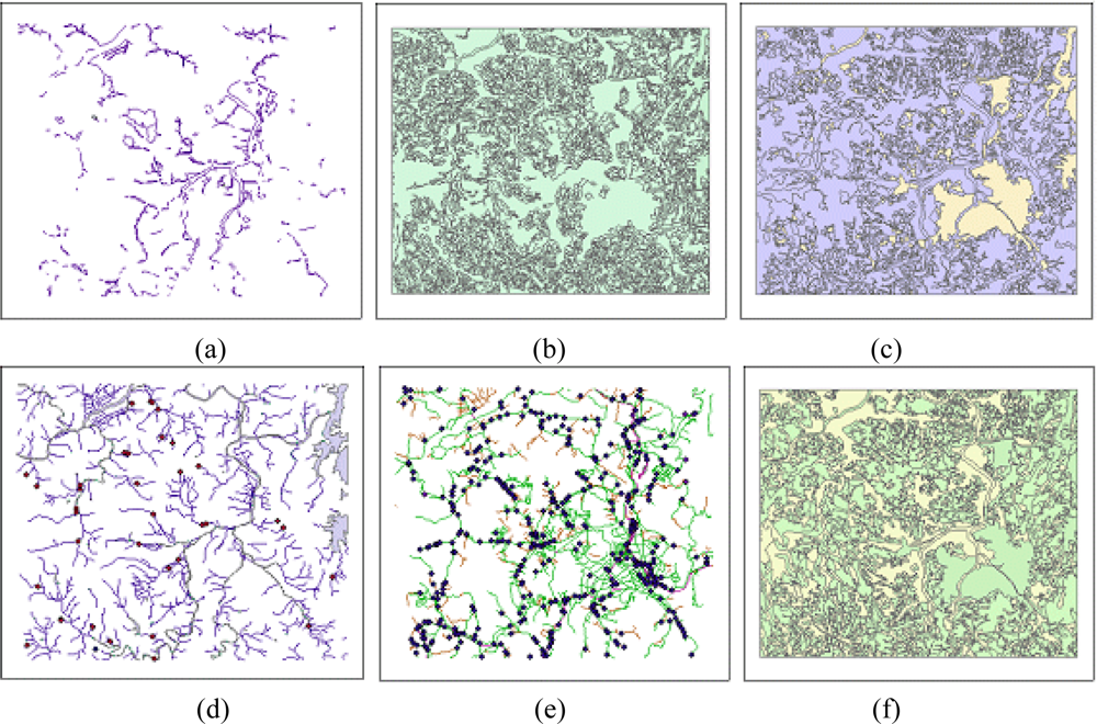
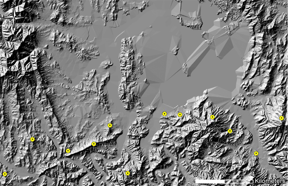
2.1. Description of Input Data
2.2. Thermal Observation Device (TOD)
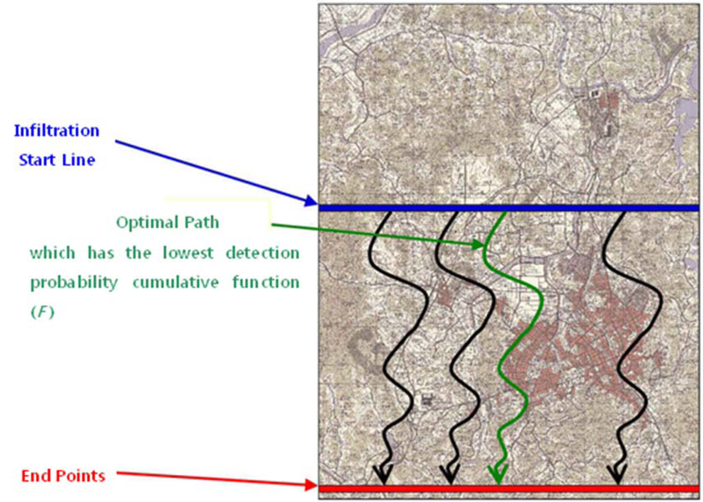
2.3. Optimal Infiltration-Route Analysis
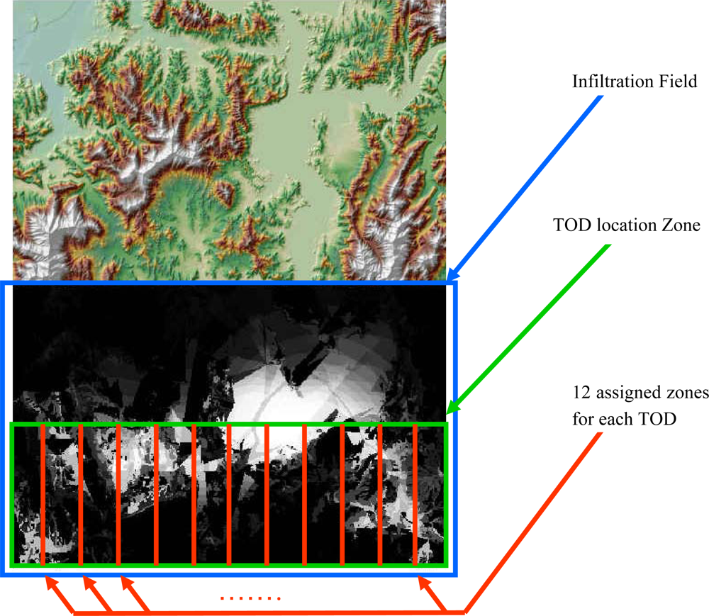
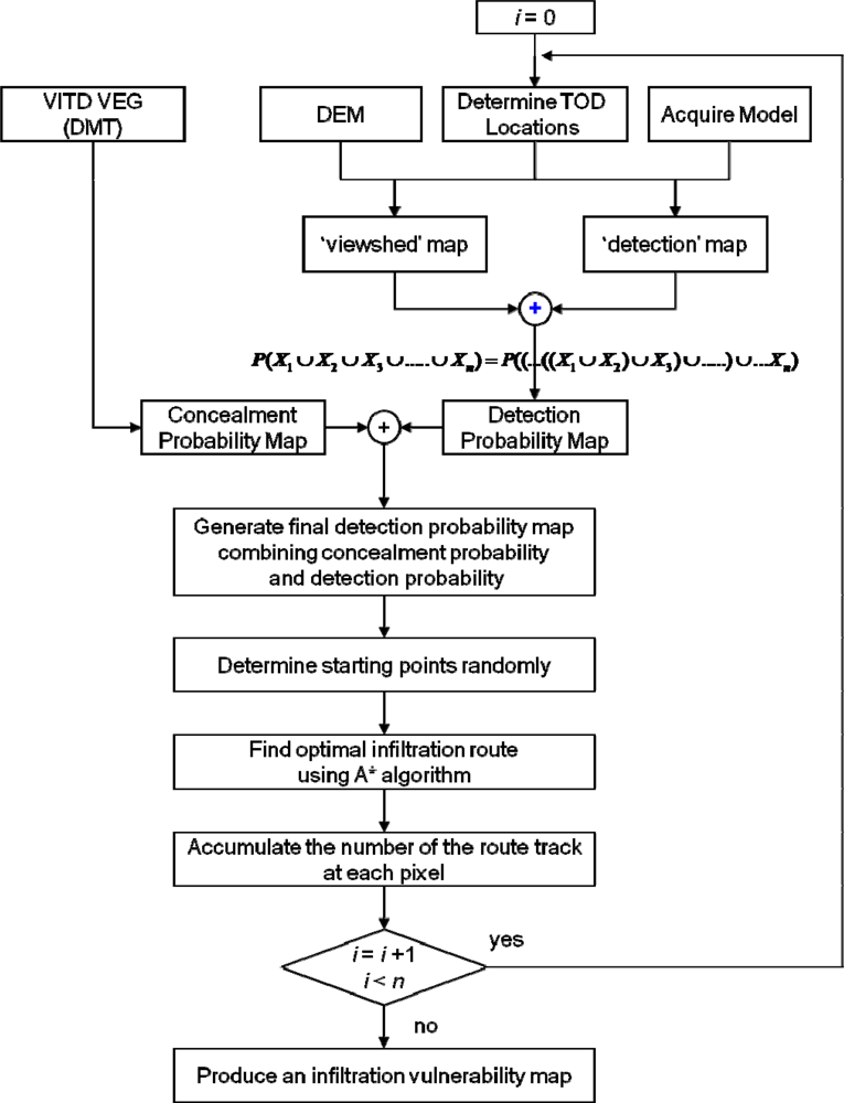
3. Simulation Design
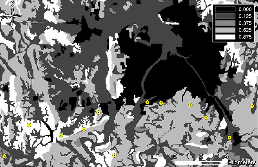
3.1. Concealment Probability
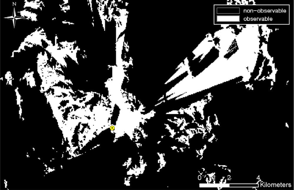
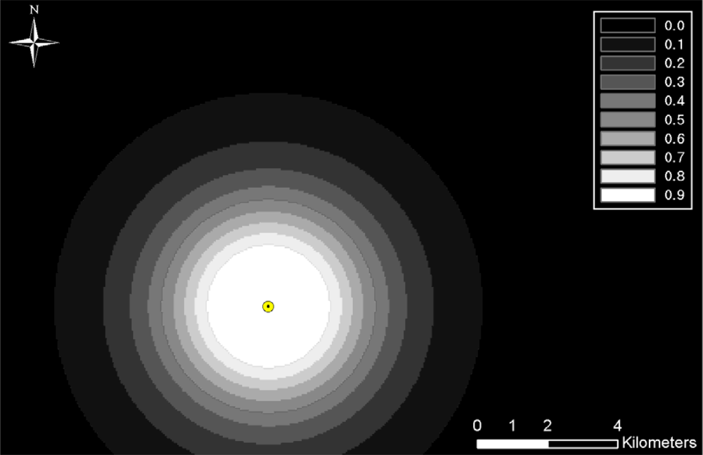
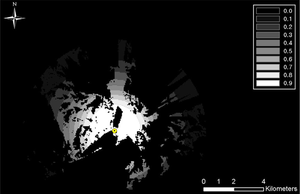
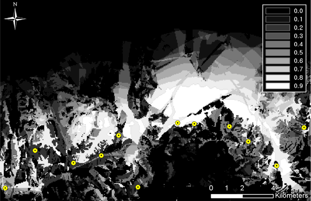
3.2. Viewshed Analysis and TOD Detection Probability
3.3. Detection Probability Map
3.4. Dynamic Simulations
3.5. Optimization Algorithms
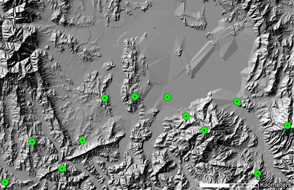
4. Experiments and Analyses
5. Summary and Conclusions
References
- Lillesand, T.M. Use of High-Resolution Remote Sensing for Gas-Line Route Selection. In Affiliated Research Center Final Report (ARC-UWM-004-97); Environmental Remote Sensing Center in University of Wisconsin-Madison and Commercial Remote Sensing Program in NASA: Madison, WI, USA, 1998. [Google Scholar]
- Delavar, M.R.; Naghibi, F. Pipiline Routing Using Geospatial Information System Analysis. Proceedings of 9th Scandinavian Research Conference on Geographical Information Science, Espoo, Finland, June 2003.
- Jong, J.C.; Manoj, K.J.; Paul, S. Preliminary Highway Design with Genetic Algorithms and Geographic Information Systems. Comput.-Aided Civ. Infrastruct. Eng 2000, 15, 261–271. [Google Scholar]
- Musa, M.K.A.; Mohammed, A.N. Alignment and Locating Forest Road Network by Best-Path Modeling Method. Proceedings of 23rd Asian Conference on Remote Sensing, Kathmandu, Nepal, November, 2002.
- Stewart, L.A. The Application of Route Network Analysis to Commercial Forestry Transportation. Proceedings of 2005 ESRI International User Conference, San Diego, CA, USA, July 2005.
- Thirumalaiah, K.; Deo, M.C. Real-Time Flood Forecasting Using Neural Networks. Comput.-Aided Civ. Infrastruct. Eng 1998, 13, 101–111. [Google Scholar]
- Yeu, B.M.; Seo, J.H.; Jo, H.S. A Study on the Tactical Databases of the Army. J. Korean Soc. Geosp. Inf. Syst 1994, 2, 107–119. [Google Scholar]
- Ham, Y.K.; Kim, Y.H.; Joo, J.C. Information Analysis for Special War. In Research Report (KTRC-409-000221L); Agency for Defense Development: Taejon, Korea, 2000. [Google Scholar]
- Meng, A.C.C. AMPES: Adaptive Mission Planning Expert System for Air Mission Tasks. Proceedings of the IEEE National Aerospace and Electronics Conference, Seattle, WA, USA, 1988.
- John, M.; Panton, D.; White, K. Mission Planning for Regional Surveillance. Ann. Oper. Res 2001, 108, 157–173. [Google Scholar]
- Helgason, R.V.; Kennington, J.L.; Lewis, K.R. Cruise Missile Mission Planning: A Heuristic Algorithm for Automatic Path Generation. J. Heuristics 2001, 7, 473–494. [Google Scholar]
- Dial, R.B. Algorithm 360: Shortest-Path Forest with Topological Ordering. Commun. ACM 1969, 12, 632–633. [Google Scholar]
- Ahuja, R.K.; Magnanti, T.L.; Orlin, J.B. Network Flows: Theory, Algorithms and Applications; Prentice Hall: Englewood Cliffs, NJ, USA, 1993. [Google Scholar]
- Dijkstra, E. A Note on Two Problems in Connection with Graphs. Numer. Math 1959, 1, 269–271. [Google Scholar]
- Cherkassky, B.A.; Goldberg, A.V.; Radzik, T. Shortest Paths Algorithms: Theory and Experimental Evaluation. Math. Program 1996, 73, 129–174. [Google Scholar]
- Hart, P.E.; Nilsson, N.J.; Raphael, B. Correction to a Formal Basis for the Heuristic Algorithm for Automatic Path Planning. SIGART Newslett 1972, 37, 28–29. [Google Scholar]
- Marti, J.; Bunn, C. Automated Path Planning for Simulation. Proceedings of the Annual Conference on AI, Simulation, and Planning in High Autonomy Systems, Gainesville, FL, USA, December 1994; pp. 122–128.
- Kwok, K.S.; Driessen, B.J. Path Planning for Complex Terrain Navigation via Dynamic Programming. Proceedings of the American Control Conference, San Diego, CA, USA, June 1999; 4, pp. 2941–2944.
- Howard, A.; Seraji, H.; Werger, B. Fuzzy Terrain-Based Path Planning for Planetary Rovers. Proceedings of the IEEE International Conference on Fuzzy Systems, Honolulu, HI, USA, May 2002; 1, pp. 316–320.
- Niederberger, C.; Radovic, D.; Gross, M. Generic Path Planning for Real-Time Applications. Proceedings of Computer Graphics International, Crete, Greece, June 2004; pp. 299–306.
- Saha, A.K.; Arora, M.K.; Gupta, R. P.; Virdi, M. L.; Csaplovics, E. GIS-Based Route Planning in Landslide-Prone Areas. Int. J. Geogr. Inf. Sci 2005, 19, 1149–1175. [Google Scholar]
- Smith, M.J. Determination of Gradient and Curvature Constrained Optimal Paths. Comput.-Aided Civ. Infrastruct. Eng 2006, 21, 24–38. [Google Scholar]
- Caccetta, L.; van Loosen, I.; Rehbock, V. Effective Algorithms for a Class of Discrete Valued Optimal Control Problems. Optim. Coop. Control Strateg 2009, 381, 1–30. [Google Scholar]
- National Geospatial-Intelligence Agency (NGA) Vector product Interim Terrain Data (VITD). In Military Performance Specifications (MIL-PRF-89040A). 1996. Available online: http://www.nga.mil/ast/fm/acq/MIL-PRF-89040AVITD.pdf/ (accessed on 20 March 2007).
- Lloyd, J.M. Thermal imaging systems; Plenum Press: New York, NY, USA, 1975. [Google Scholar]
- Hong, S.M.; Kim, C.W.; Yu, W.K.; Choi, S.C.; Lee, J.H. Field Test Results of Thermal Imaging Systems. In Test and Evaluation Report (TEDC-317-030544); Agency for Defense Development: Taejon, Korea, 2003. [Google Scholar]
- Russell, S.; Norvig, P. Artificial Intelligence: A Modern Approach; Prentice-Hall: Englewood Cliffs, NJ, USA, 1995. [Google Scholar]


| Operational frequency | far infrared(8∼12 μm) |
| Scanning method | 1st generation serial-parallel scanning |
| Magnification | 3∼10 × duplex magnification infrared optic |
| Resolution | 0.24 mega pixels |
| Monitor | 9 inch |
| Focusing range | 30 m∼infinity |
| Tripod height | 47 cm∼104 cm |
| Operation | directly/indirectly/vehicle mounted |
| Field of view | 3 × (6.3° × 10.1°) in wide mode |
| 10 × (2.0° × 3.1°) in narrow mode | |
| Power consumption | DC 24 V ± 6 V (direct operation) |
| AC 90 V∼245 V (remote operation) | |
| Spinning angle | horizontal: 360°, vertical: ± 22.5° (direct operation) |
| horizontal: 350°, vertical: ± 80.0° (remote operation) | |
| Rotational speed | horizontal:1.5°/sec ∼12.0°/sec, vertical: 0.3°/sec ∼1.5°/sec |
| Layer | vegarea | vgfarea | vgfarea | vgfarea | vgfarea | vfwarea |
|---|---|---|---|---|---|---|
| DMT (%) | - | 0–25 | 25–50 | 50–75 | 75–100 | - |
| Concealment probability | 0.125 | 0.125 | 0.375 | 0.625 | 0.875 | 0.125 |
©2010 by the authors; licensee Molecular Diversity Preservation International, Basel, Switzerland. This article is an open access article distributed under the terms and conditions of the Creative Commons Attribution license (http://creativecommons.org/licenses/by/3.0/)
Share and Cite
Bang, S.; Heo, J.; Han, S.; Sohn, H.-G. Infiltration Route Analysis Using Thermal Observation Devices (TOD) and Optimization Techniques in a GIS Environment. Sensors 2010, 10, 342-360. https://doi.org/10.3390/s100100342
Bang S, Heo J, Han S, Sohn H-G. Infiltration Route Analysis Using Thermal Observation Devices (TOD) and Optimization Techniques in a GIS Environment. Sensors. 2010; 10(1):342-360. https://doi.org/10.3390/s100100342
Chicago/Turabian StyleBang, Soonam, Joon Heo, Soohee Han, and Hong-Gyoo Sohn. 2010. "Infiltration Route Analysis Using Thermal Observation Devices (TOD) and Optimization Techniques in a GIS Environment" Sensors 10, no. 1: 342-360. https://doi.org/10.3390/s100100342