22 pages, 13659 KiB  
Article
Proposal of a Method for Identifying Socio-Economic Spatial Concentrations for the Development of Rural Areas: An Application to the Apulia Region (Southern Italy)
by Marilena Labianca
Sustainability 2023, 15(4), 3180; https://doi.org/10.3390/su15043180 - 9 Feb 2023
Cited by 6 | Viewed by 3385
Abstract
In the international debate, the relationship between sustainable management in agriculture and the enhancement of landscapes is recent and is discussed in various international agendas. These objectives are connected to a growing demand for sustainable agricultural practices, quality productions, and ecosystem services in [...] Read more.
In the international debate, the relationship between sustainable management in agriculture and the enhancement of landscapes is recent and is discussed in various international agendas. These objectives are connected to a growing demand for sustainable agricultural practices, quality productions, and ecosystem services in which farmers and institutions play a strategic role. According to the literature and international guidelines, new functions, and territorial connections can produce added value, especially in marginal rural areas. In this study, the aim is to investigate the factors that allow potential spatial concentrations for sustainable rural development to be identified, placing the landscape at the center of the research. Starting from a literature review, we select specific indicators and variables and analyze them combining Principal Component Analysis and cartographic analysis. The method applied to a region of significant importance in Italy, Apulia, has highlighted the importance of specific factors and significant imbalances, especially in marginal municipalities. The method, applicable in different regional contexts, can represent a useful policy tool, especially in marginal rural areas because it allows us to identify the geography of socio-economic spatial concentrations, suggesting interventions and actions in line with international agendas, such as Common Agricultural Policy reform and Green Deal. Full article
Show Figures

Figure 1

19 pages, 2495 KiB  
Article
Heuristic Surface Path Planning Method for AMV-Assisted Internet of Underwater Things
by Jie Zhang, Zhengxin Wang, Guangjie Han and Yujie Qian
Sustainability 2023, 15(4), 3137; https://doi.org/10.3390/su15043137 - 8 Feb 2023
Cited by 3 | Viewed by 2538
Abstract
Ocean exploration is one of the fundamental issues for the sustainable development of human society, which is also the basis for realizing the concept of the Internet of Underwater Things (IoUT) applications, such as the smart ocean city. The collaboration of heterogeneous autonomous [...] Read more.
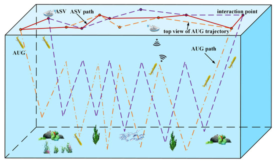
Ocean exploration is one of the fundamental issues for the sustainable development of human society, which is also the basis for realizing the concept of the Internet of Underwater Things (IoUT) applications, such as the smart ocean city. The collaboration of heterogeneous autonomous marine vehicles (AMVs) based on underwater wireless communication is known as a practical approach to ocean exploration, typically with the autonomous surface vehicle (ASV) and the autonomous underwater glider (AUG). However, the difference in their specifications and movements makes the following problems for collaborative work. First, when an AUG floats to a certain depth, and an ASV interacts via underwater wireless communication, the interaction has a certain time limit and their movements to an interaction position have to be synchronized; secondly, in the case where multiple AUGs are exploring underwater, the ASV needs to plan the sequence of surface interactions to ensure timely and efficient data collection. Accordingly, this paper proposes a heuristic surface path planning method for data collection with heterogeneous AMVs (HSPP-HA). The HSPP-HA optimizes the interaction schedule between ASV and multiple AUGs through a modified shuffled frog-leaping algorithm (SFLA). It applies a spatial-temporal k-means clustering in initializing the memeplex group of SFLA to adapt time-sensitive interactions by weighting their spatial and temporal proximities and adopts an adaptive convergence factor which varies by algorithm iterations to balance the local and global searches and to minimize the potential local optimum problem in each local search. Through simulations, the proposed HSPP-HA shows advantages in terms of access rate, path length and data collection rate compared to recent and classic path planning methods. Full article
(This article belongs to the Special Issue Smart Urban and IoT: Advances, Opportunities and Challenges)
Show Figures

Figure 1

27 pages, 31135 KiB  
Article
The Relationship between the Color Landscape Characteristics of Autumn Plant Communities and Public Aesthetics in Urban Parks in Changsha, China
by Yuanyuan Luo, Jun He, Yuelin Long, Lu Xu, Liang Zhang, Zhuoran Tang, Chun Li and Xingyao Xiong
Sustainability 2023, 15(4), 3119; https://doi.org/10.3390/su15043119 - 8 Feb 2023
Cited by 16 | Viewed by 4903
Abstract
Contemporary landscape architecture studies have paid close attention to the interactions between public aesthetic preferences and the landscape environment. Scenic beauty has become an important evaluation indicator of landscape quality. The quality of the plant color landscape is an important factor affecting scenic [...] Read more.
Contemporary landscape architecture studies have paid close attention to the interactions between public aesthetic preferences and the landscape environment. Scenic beauty has become an important evaluation indicator of landscape quality. The quality of the plant color landscape is an important factor affecting scenic beauty. Exploring the relationship between the composition rules and internal properties of autumn plant color landscapes in urban parks and public aesthetic preferences can provide new ideas for the evaluation and design of plant community color landscapes. Taking 12 parks in Changsha City, Hunan Province, China, as the study area and 85 plant communities as the sample plots, scenic beauty estimation (SBE) was used to evaluate the autumn plant color landscape of urban parks. ColorImpact software was used to extract the color values of each plant community. Fifteen original color element indicators were determined, and the data were statistically analyzed by principal component analysis (PCA), one-way ANOVA, multiple comparison analysis and systematic cluster analysis. Four principal components were extracted to construct the characteristic indices and a comprehensive model of the color landscape quality of autumn plant communities. The four characteristic indices showed significant or extremely significant differences among the five SBE grades. From the overall trend, the SBE grades showed a positive correlation with PC1 (primary and adjunctive color index), PC2 (color structure and property index) and PC3 (autumn-color-leafed index) and a negative correlation with PC4 (intersperse color index). RPH (ratio of primary hue), RP (ratio of primary color), RC (color-leafed index), RWC (ratio of warm and cool colors), and NC (number of colors) were the key factors affecting the SBE grade. Overall, RPH, RP, RC, and RWC positively influenced the SBE values, while NC negatively influenced the SBE values, and five to seven colors were more moderate. The quality of the color landscape can be improved by creating plant communities with three types of color composition: warm-toned dominant type, warm- and cold-toned contrast type, and multicolor harmonic type. The results provide a reference for the evaluation, design and construction of autumn plant color landscapes in urban parks. Full article
(This article belongs to the Section Sustainable Urban and Rural Development)
Show Figures

Figure 1

20 pages, 10006 KiB  
Article
Spatial–Temporal Heterogeneity of Urbanization and Ecosystem Services in the Yellow River Basin
by Zhongwu Zhang, Jinyuan Zhang, Liping Liu, Jian Gong, Jinqiang Li and Lei Kang
Sustainability 2023, 15(4), 3113; https://doi.org/10.3390/su15043113 - 8 Feb 2023
Cited by 11 | Viewed by 2505
Abstract
Taking 736 counties in the Yellow River Basin of China as the research area, the comprehensive urbanization development level and ecosystem service capacity from 2000 to 2020 were measured. Combined with spatial autocorrelation, the spatial pattern evolution characteristics of the two systems in [...] Read more.
Taking 736 counties in the Yellow River Basin of China as the research area, the comprehensive urbanization development level and ecosystem service capacity from 2000 to 2020 were measured. Combined with spatial autocorrelation, the spatial pattern evolution characteristics of the two systems in the Yellow River Basin were revealed. The spatio–temporal geographically weighted regression (GTWR) model was used to analyze the spatio–temporal heterogeneity of the impact of various elements of the system on urbanization and ecosystem service capacity. The results showed that (1) the urbanization level and ecosystem service capacity of the Yellow River Basin were on the rise but the urbanization level and ecosystem service capacity were low, while the spatial and temporal heterogeneity was significant. (2) The two systems are positively correlated in space, and the agglomeration characteristics are significant. The evolution trend of urbanization from an L–L agglomeration area to an H–H agglomeration area is occurring gradually. The spatial change in the ecosystem service agglomeration area is small, and the stability is strong. (3) The impact of ecosystem services on comprehensive urbanization is enhanced by time, and the spatial ‘center–periphery’ diffusion characteristics are significant. (4) The influence of urbanization on the comprehensive ecosystem service capacity is enhanced and shows the law of east–west differentiation in space. There are obvious transition zones in the spatial heterogeneity interval of the interaction between the two systems. Full article
(This article belongs to the Special Issue Advances in Ecosystem Services and Urban Sustainability)
Show Figures

Figure 1

30 pages, 9232 KiB  
Article
A Research Paradigm for Industrial Spatial Layout Optimization and High-Quality Development in The Context of Carbon Peaking
by Yang Zhang, Wenlong Li, Jiawen Sun, Haidong Zhao and Haiying Lin
Sustainability 2023, 15(4), 3105; https://doi.org/10.3390/su15043105 - 8 Feb 2023
Cited by 5 | Viewed by 1959
Abstract
The reasonable spatial layout of industries is crucial to carbon reduction and high-quality economic development. This paper establishes a research paradigm for optimizing the industrial spatial layout and high-quality development in the context of carbon peaking. Based on the perspectives of industrial transfer, [...] Read more.
The reasonable spatial layout of industries is crucial to carbon reduction and high-quality economic development. This paper establishes a research paradigm for optimizing the industrial spatial layout and high-quality development in the context of carbon peaking. Based on the perspectives of industrial transfer, the static agglomeration index, dynamic agglomeration index, industrial gradient coefficient, and low-carbon competitiveness index are used to analyze industrial agglomeration, competition status, and low-carbon competitiveness. Taking the Great Bend of the Yellow River (the Bend) as an example, we analyze the current situation in industrial development, guide the orderly transfer of industry, and optimize the spatial layout of industries to achieve high-quality economic development. The results show that resource- and capital-intensive industries have obvious advantages in agglomeration, competitive edge, and low-carbon competitiveness, while labor- and technology-intensive industries have weak advantages. The spatial layout of agglomerated industries was analyzed across four types of factor-intensive industries; these industries are the focus of industrial layout in the Bend. Promising industries were observed in all types of factor-intensive industries except capital-intensive industries, and these industries should be cultivated carefully in all provinces. Scale industries were mainly observed in resource- and capital-intensive industries; these industries should be transformed and upgraded to control the total amount and intensity of carbon emissions. The study’s findings provide a basis for optimizing the spatial layout of industries and reducing carbon emissions through industrial transfer in the context of carbon peaking. The relevant industries should be transformed and upgraded to control the total amount and intensity of carbon emissions. Full article
(This article belongs to the Special Issue Urbanization and Regional Economies towards Sustainability)
Show Figures

Figure 1

18 pages, 309 KiB  
Article
The Transaction Costs of Sustainability: Coase’s Proviso and the Roles of Environmentalists and the Government
by Aleksandar D. Slaev
Sustainability 2023, 15(4), 3096; https://doi.org/10.3390/su15043096 - 8 Feb 2023
Cited by 2 | Viewed by 2447
Abstract
Environmentalists believe that the Coasean approach is economically efficient but environmentally unsustainable. While acknowledging that this approach is not always sustainable, this paper emphasises its important advantage—the presence of a criterion determining when an activity will/will not lead to an efficient/sustainable outcome. Coase [...] Read more.
Environmentalists believe that the Coasean approach is economically efficient but environmentally unsustainable. While acknowledging that this approach is not always sustainable, this paper emphasises its important advantage—the presence of a criterion determining when an activity will/will not lead to an efficient/sustainable outcome. Coase formulated this criterion on what is termed in this paper “Coase’s proviso”—the balance between the net benefits of an institutional change (rearrangement of entitlements) and transaction costs associated with this change. The article also defines the terms “best use”, “second (or next) best use” and “best user”. On this basis, the paper restates Coase’s proviso and argues that there is no inherent contradiction between economic efficiency and environmental sustainability. According to the restated proviso, when the transaction costs associated with the institutional transformation establishing the best use of a resource are lower than the net benefits of this transformation, the result will be economically efficient and environmentally sustainable. However, if the transaction costs outweigh the net benefits of the best use, a second (or next) best use may be established, which will still be economically efficient, but most likely environmentally unsustainable. The paper explores a case study to check the relevance of the restated proviso. Full article
(This article belongs to the Special Issue Transaction Costs and Policy Analysis)
23 pages, 4307 KiB  
Article
Describing Micro-Mobility First/Last-Mile Routing Behavior in Urban Road Networks through a Novel Modeling Approach
by Panagiotis G. Tzouras, Lambros Mitropoulos, Katerina Koliou, Eirini Stavropoulou, Christos Karolemeas, Eleni Antoniou, Antonis Karaloulis, Konstantinos Mitropoulos, Eleni I. Vlahogianni and Konstantinos Kepaptsoglou
Sustainability 2023, 15(4), 3095; https://doi.org/10.3390/su15043095 - 8 Feb 2023
Cited by 18 | Viewed by 4058
Abstract
E-scooters aspire to provide flexibility to their users while covering the first/last mile of a multimodal trip. Yet, their dual travel behavior, i.e., utilizing both vehicles’ roadways and pedestrians’ sidewalks, creates new challenges to transport modelers. This study aims to model e-scooter riding [...] Read more.
E-scooters aspire to provide flexibility to their users while covering the first/last mile of a multimodal trip. Yet, their dual travel behavior, i.e., utilizing both vehicles’ roadways and pedestrians’ sidewalks, creates new challenges to transport modelers. This study aims to model e-scooter riding behavior in comparison to traditional urban transport modes, namely car and walking. The new modeling approach is based on perceived safety that is influenced by the road environment and affects routing behavior. An ordinal logistic model of perceived safety is applied to classify road links in a 7-point Likert scale. The parametric utility function combines only three basic parameters: time, cost, and perceived safety. First/last mile routing choices are modeled in a test road network developed in Athens, Greece, utilizing the shortest-path algorithm. The proposed modeling approach proved to be useful, as the road environment of an urban area is heterogenous in terms of safety perceptions. Indeed, the model outputs show that the flexibility of e-scooters is limited in practice by their low-perceived safety. To avoid unsafe road environments where motorized traffic dominates, e-scooter riders tend to detour. This decision-making process tool can identify road network discontinuities. Nevertheless, their significance regarding routing behavior should be further discussed. Full article
(This article belongs to the Special Issue Transportation Planning and Urban Sustainability)
Show Figures

Figure 1

21 pages, 1031 KiB  
Article
The Performance of the Construction of a Water Ecological Civilization City: International Assessment and Comparison
by Qimeng Yue, Kate Heal, Jingshan Yu, Qianyang Wang, Yuexin Zheng, Zhanliang Zhu, Yuan Liu, Shugao Xu and Xiaolei Yao
Sustainability 2023, 15(4), 3071; https://doi.org/10.3390/su15043071 - 8 Feb 2023
Cited by 4 | Viewed by 2676
Abstract
The water ecological environment problems brought about by rapid urbanization have prompted the proposal and implementation of different approaches to urban water ecological construction, such as eco-cities, best management practices (BMPs), and low-impact development (LID). As one of the most representative urban water [...] Read more.
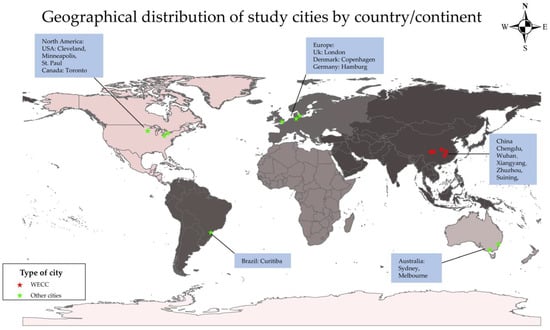
The water ecological environment problems brought about by rapid urbanization have prompted the proposal and implementation of different approaches to urban water ecological construction, such as eco-cities, best management practices (BMPs), and low-impact development (LID). As one of the most representative urban water ecological management policies in China, the Water Ecological Civilization City (WECC) was proposed in 2013, and 105 cities were selected for pilot construction. Many studies have evaluated the effectiveness of WECC construction, but international quantitative comparison is lacking. To address this, an urban Water-Human-Health (WHH) Assessment Model, considering water resources, ecological environment, economic and social development level, and water resources utilization, was developed and applied to five WECC pilot cities in China and 10 other cities worldwide, in which mainstream urban water ecological construction modes have been used. Principal component analysis of the index values in the assessment system was used to evaluate the current status of water ecosystem health in the 15 cities, showing that Sydney, Cleveland, and Hamburg were the most advanced in urban water ecological management. The two cities with the best evaluation results (Sydney and Cleveland), and the WECC city with the highest score (Wuhan) were selected for documentary analysis of their water ecological construction documents to identify similarities and differences to inform best practice internationally for urban water ecological construction. The results showed that Sydney and Cleveland attach similar emphasis across most constituents of urban water ecological construction, while, for Wuhan, greater importance is attached to water resource management and water culture. The advantages and disadvantages of WECC construction and international experience are discussed. The WHH assessment model proposed in this study provides a new quantitative evaluation method for international urban water ecological health evaluation, which could be further improved by including an urban flood risk indicator. Full article
(This article belongs to the Special Issue Green Infrastructure and Sustainable Urban Water Management)
Show Figures

Figure 1

22 pages, 1950 KiB  
Article
Local Feature Search Network for Building and Water Segmentation of Remote Sensing Image
by Zhanming Ma, Min Xia, Liguo Weng and Haifeng Lin
Sustainability 2023, 15(4), 3034; https://doi.org/10.3390/su15043034 - 7 Feb 2023
Cited by 39 | Viewed by 3641
Abstract
Extracting buildings and water bodies from high-resolution remote sensing images is of great significance for urban development planning. However, when studying buildings and water bodies through high-resolution remote sensing images, water bodies are very easy to be confused with the spectra of dark [...] Read more.
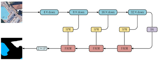
Extracting buildings and water bodies from high-resolution remote sensing images is of great significance for urban development planning. However, when studying buildings and water bodies through high-resolution remote sensing images, water bodies are very easy to be confused with the spectra of dark objects such as building shadows, asphalt roads and dense vegetation. The existing semantic segmentation methods do not pay enough attention to the local feature information between horizontal direction and position, which leads to the problem of misjudgment of buildings and loss of local information of water area. In order to improve this problem, this paper proposes a local feature search network (DFSNet) application in remote sensing image building and water segmentation. By paying more attention to the local feature information between horizontal direction and position, we can reduce the problems of misjudgment of buildings and loss of local information of water bodies. The discarding attention module (DAM) introduced in this paper reads sensitive information through direction and location, and proposes the slice pooling module (SPM) to obtain a large receptive field in the pixel by pixel prediction task through parallel pooling operation, so as to reduce the misjudgment of large areas of buildings and the edge blurring in the process of water body segmentation. The fusion attention up sampling module (FAUM) guides the backbone network to obtain local information between horizontal directions and positions in spatial dimensions, provide better pixel level attention for high-level feature maps, and obtain more detailed segmentation output. The experimental results of our method on building and water data sets show that compared with the existing classical semantic segmentation model, the proposed method achieves 2.89% improvement on the indicator MIoU, and the final MIoU reaches 83.73%. Full article
(This article belongs to the Special Issue Remote Sensing, Sustainable Land Use and Smart City)
Show Figures

Figure 1

33 pages, 4843 KiB  
Article
Assessing the Sustainability of Urban Community Renewal Projects in Southern China Based on a Hybrid MADM Approach
by Junpai Chen, Yue Chen, Yitong Zhu, Mingyan Xiao, Hongfei Yang, Huaming Huang and Linli Li
Sustainability 2023, 15(4), 3023; https://doi.org/10.3390/su15043023 - 7 Feb 2023
Cited by 7 | Viewed by 5051
Abstract
Urban renewal is extensively practiced around the world and has attracted substantial attention among scholars and the public. To ensure that urban renewal is directed toward sustainable development goals, sustainability assessments for urban renewal projects have become critical topics. Simultaneously, the ex ante [...] Read more.
Urban renewal is extensively practiced around the world and has attracted substantial attention among scholars and the public. To ensure that urban renewal is directed toward sustainable development goals, sustainability assessments for urban renewal projects have become critical topics. Simultaneously, the ex ante evaluation research of urban renewal projects has not received enough academic attention, and most results have not fully considered the localization of criteria and the internal correlation between criteria/dimensions. Therefore, this paper proposes an ex ante decision model for the sustainability assessment of urban renewal projects based on a hybrid multiple-attribute decision-making (MADM) approach, which includes 3 dimensions and 16 criteria. It uses a case in Guangzhou to assess the sustainable potential of the project and explore relevant improvement strategies. Empirical results from the Decision Testing and Evaluation Laboratory (DEMATEL) indicate that the economic (D1) and environment (D2) dimensions both impact the social and cultural (D3) dimensions, with the environment (D2) dimension being impacted by the economic (D1) dimension. The criteria occupying the “cause” position include reducing construction costs and materials expenses (C5), increasing greening configuration and open space (C6), reducing resource consumption and waste (C8), improving existing land-use efficiency (C2), promoting the biodiversity of space (C9), and strengthening the safety of pedestrians and residents (C15), where increasing greening configurations and open space (C6) and reducing resource consumption and waste (C5) are considered the key criteria based on the results of DEMATEL and the DEMATEL-Analytic Network Process (DANP). The modified VlseKriterijumska Optimizacija I Kompromisno Resenje (VIKOR) method revealed that the economic (D1) dimension has poor performance, and its improvement needs to be prioritized. Further improvement strategies are proposed based on the influence network relationship graph (INRM). In conclusion, our results show that urban community renewal projects in Guangzhou are steadily progressing toward a sustainable vision. Full article
(This article belongs to the Section Sustainable Urban and Rural Development)
Show Figures

Figure 1

15 pages, 1855 KiB  
Article
Exploring the Potential of Co-Application of Sewage Sludge, Chinese Medicinal Herbal Residues and Biochar in Minimizing Human Exposure to Antibiotics Contamination in Edible Crops
by Min Pan, Hao Zhang, Li-Wen Luo and Pui-Ching Yau
Sustainability 2023, 15(4), 2980; https://doi.org/10.3390/su15042980 - 7 Feb 2023
Cited by 3 | Viewed by 1920
Abstract
Agricultural practices such as wastewater irrigation and manure application may contaminate soils with antibiotics and, consequently, lead to human health risk. The co-application of three waste-derived materials, sewage sludge (SL), Chinese medicinal herbal residues (CMHR) and biochar (BC), as a soil amendment was [...] Read more.
Agricultural practices such as wastewater irrigation and manure application may contaminate soils with antibiotics and, consequently, lead to human health risk. The co-application of three waste-derived materials, sewage sludge (SL), Chinese medicinal herbal residues (CMHR) and biochar (BC), as a soil amendment was proposed recently for minimizing the antibiotic amount in crop tissues. The fate of six antibiotics—amoxicillin, tetracycline, sulfamethazine, norfloxacin, erythromycin and chloramphenicol—were investigated in a greenhouse soil-plant system with a fruit crop species: tomato. The pots were mixed with 5%, 10% or 20% SL-BC and SL-CMHR-BC and irrigated with wastewater with 3 μg/L or 30 μg/L antibiotics. The pot containing 20% SL-CMHR-BC captured the lowest antibiotic concentration in soils and tomato tissues. Norfloxacin was the most abundant antibiotic in the fruits, followed by tetracycline. The pot containing 20% SL-CMHR-BC significantly lowered the bioconcentration factor of the fruit, while its effects on the translocation factor were more varied. Current and some previous data were used to assess the human health risk of consuming carrot, lettuce and tomato. The estimated daily intake suggested a negligible risk to human health in general compared with the acceptable daily intake, except for CAP. A concentration of 20% SL-CMHR-BC helps minimize the human exposure risk to antibiotics contamination in edible crops. Full article
Show Figures

Figure 1

26 pages, 3947 KiB  
Article
Libro del Edificio Electrónico (LdE-e): Advancing towards a Comprehensive Tool for the Management and Renovation of Multifamily Buildings in Spain
by Paúl Espinoza-Zambrano, Carlos Marmolejo-Duarte and Alejandra García-Hooghuis
Sustainability 2023, 15(4), 2957; https://doi.org/10.3390/su15042957 - 6 Feb 2023
Cited by 9 | Viewed by 2626
Abstract
In 2018, the Energy Performance of Buildings Directive (EPBD) introduced Building Renovation Passports (BRP) to enable buildings to scale energy performance through a Scheduled Renovations Roadmap (SRR). The Digital Building Logbook (DBL) was introduced in 2021 as a repository of relevant building data [...] Read more.
In 2018, the Energy Performance of Buildings Directive (EPBD) introduced Building Renovation Passports (BRP) to enable buildings to scale energy performance through a Scheduled Renovations Roadmap (SRR). The Digital Building Logbook (DBL) was introduced in 2021 as a repository of relevant building data to facilitate informed decision-making and information sharing among stakeholders. In Spain, both tools (DBL + SRR) have been studied separately in an incipient way. However, the interconnection of data in the tools come from the same document base. Evidence suggests that when building information is used in isolation, its value is diluted without stakeholder awareness. In this paper, we move towards unifying both tools (DBL+SRR) in a single comprehensive tool called the Libro del Edificio Electrónico (LdE-e), with the aim of producing a single building database to drive multi-building renovations. For this purpose, the data fields of existing building information, assessment and management tools in Spain were studied in detail and reinterpreted in a new interconnected data structure. To evaluate the formulation of the LdE-e proposal, 11 semi-structured interviews were held with a panel of 13 experts specialized in real estate, building and energy efficiency. After these sessions, the LdE-e was reformulated, and the model was strengthened by analyzing vectors such as governance, management, usability, data flows, stakeholders and the impact of including new technologies such as BIM and blockchain. The results suggest that the LdE-e would improve control of the operation and maintenance of (new or existing) buildings, the programming of renovation actions based on deficits identified in technical inspections, and other aspects. Full article
Show Figures

Figure 1

21 pages, 2284 KiB  
Article
Development of Rural Regions in China: Evidence of Industry Integration by the Residents of Yongan Village (Quanzhou City, China)
by Yanyu Wang and Robert Tian
Sustainability 2023, 15(4), 2928; https://doi.org/10.3390/su15042928 - 6 Feb 2023
Cited by 6 | Viewed by 2731
Abstract
This study aims to probe the sustainable development issues in Chinese rural regions. It analyzes the primary, secondary, and tertiary industries by considering the experiences of Yongan village in Quanzhou, China, as a case study. Integrating primary, secondary, and tertiary industries is essential [...] Read more.
This study aims to probe the sustainable development issues in Chinese rural regions. It analyzes the primary, secondary, and tertiary industries by considering the experiences of Yongan village in Quanzhou, China, as a case study. Integrating primary, secondary, and tertiary industries is essential to promoting rural areas’ transformation, upgrading, and development. Yongan village in Quanzhou City, Fujian Province, China, has attempted to integrate primary, secondary, and tertiary industries. Yongan village has creatively practiced the development model of “1 + 3 + 2” (from the primary industry to the tertiary industry and then to the secondary industry). Based on the exploration of Yongan village’s experience, it is proposed to design a program for integrating primary, secondary, and tertiary industries. The study of Yongan village example will enrich the related theories and provide theoretical guidance and practical reference for related practices in rural areas in China and other developing countries. This study’s novelty is that it offers a unique rural development model based on “1 + 3 + 2”. The tertiary industry’s development precedes the secondary industry, paving the way for agro-tourism that leads to the sustainable development of the rural regions with sustained economic activity accelerated by rising tourist inflow. Full article
(This article belongs to the Section Sustainable Urban and Rural Development)
Show Figures

Figure 1

27 pages, 1946 KiB  
Review
Antecedents of Electric Vehicle Purchase Intention from the Consumer’s Perspective: A Systematic Literature Review
by Gulnaz Ivanova and António Carrizo Moreira
Sustainability 2023, 15(4), 2878; https://doi.org/10.3390/su15042878 - 5 Feb 2023
Cited by 50 | Viewed by 12935
Abstract
The growing demand for conventional internal combustion engine vehicles can aggravate the current energy and environmental crisis by presenting a higher dependence on fossil fuels and a higher level of greenhouse gases. The transition to electric mobility is a sustainable solution to mitigate [...] Read more.
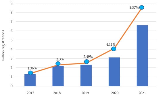
The growing demand for conventional internal combustion engine vehicles can aggravate the current energy and environmental crisis by presenting a higher dependence on fossil fuels and a higher level of greenhouse gases. The transition to electric mobility is a sustainable solution to mitigate the negative impact on the environment and energy security. In recent years, global sales of electric vehicles (EVs) have grown steadily; however, their worldwide market share is still less than 10%. The present study aims to improve and strengthen the knowledge base on consumer behavior toward EV purchases by investigating the antecedents of EV purchase intention, as well as their impact. This paper is based on a systematic literature review where 63 articles published between 1994 and 2021 were analyzed. The antecedents were classified into three main categories: consumer characteristics, EV characteristics, and EV-related policies. A summary model represents the impact information of each of the main antecedents. The descriptive results of the sample are also discussed. Finally, this study indicates directions for future research and recommendations for developing the most effective strategies and policies that will accelerate the transition to a more sustainable future. Full article
(This article belongs to the Special Issue Analysis in Urban Public Transportation Sustainability)
Show Figures

Figure 1

22 pages, 4078 KiB  
Article
Research on the Dynamic Coupling and Coordination of Science and Technology Innovation and Sustainable Development in Anhui Province
by Liyan Sun, Zhuoying Wang and Li Yang
Sustainability 2023, 15(4), 2874; https://doi.org/10.3390/su15042874 - 5 Feb 2023
Cited by 6 | Viewed by 2410
Abstract
The coupling of and coordination between science and technology innovation (STI) and sustainable development (SD) is a basic requirement for Anhui Province’s economic high-quality development. According to panel data of 16 prefecture-level cities in Anhui Province from 2010 to 2021, the entropy method [...] Read more.
The coupling of and coordination between science and technology innovation (STI) and sustainable development (SD) is a basic requirement for Anhui Province’s economic high-quality development. According to panel data of 16 prefecture-level cities in Anhui Province from 2010 to 2021, the entropy method was applied to quantify the comprehensive development level of the two systems. The models of coupling coordination degree, grey GM (1, 1), and ARIMA prediction were constructed to analyze the spatiotemporal dynamic evolution features of the two systems’ coupling coordination. In the time series, the two systems’ comprehensive development showed a steady increase, a high level of coupling, and an increasing overall trend of coupling coordination. Moreover, the two systems’ coupling and coordination levels show the gradient spatial differentiation characteristics of “central > east > west.” The prediction shows that the two systems’ coupling coordination degree exhibits a monotonic increasing trend and reaches the optimal coupling coordination state around 2030. This study provides a decision-making reference for the implementation of the innovation-driven development strategy of Anhui Province. Full article
(This article belongs to the Special Issue Urban Innovation and Sustainability)
Show Figures

Figure 1