You are currently viewing a new version of our website. To view the old version click .

Land

Land is an international, cross-disciplinary, peer-reviewed, open access journal on land system science, landscape, soil and water, urban study, land–climate interactions, water–energy–land–food (WELF) nexus, biodiversity research and health nexus, land modelling and data processing, ecosystem services, multifunctionality and sustainability, and is published monthly online by MDPI.
The International Association for Landscape Ecology (IALE), European Land-use Institute (ELI), Landscape Institute (LI) and Urban Land Institute (ULI) are affiliated with Land, and their members receive discounts on the article processing charges.
Quartile Ranking JCR - Q2 (Environmental Studies)

All Articles (11,823)

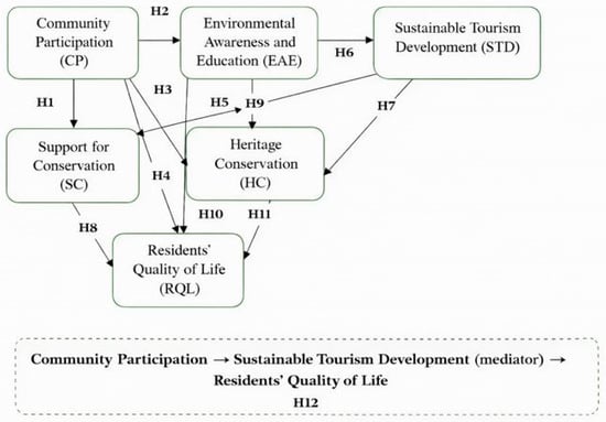
This study explores the interrelationships between community participation, environmental awareness and education, heritage conservation, and sustainable tourism development in shaping quality of life and conservation support in the Mt. Rtanj protected area, Serbia. Using a quantitative approach, data were collected from local residents of Boljevac and Sokobanja municipalities and analyzed through structural equation modeling (SEM). The results confirmed all hypothesized relationships, indicating that active participation and environmental education significantly enhance sustainable tourism development, conservation support, and quality of life. The findings highlight the need for inclusive governance, environmental education programs, and equitable benefit-sharing mechanisms to strengthen local engagement in sustainable tourism. This study contributes to the limited body of literature on sustainable tourism in Southeast European Mountain regions and offers a replicable framework for community-based conservation and development, aligned with the United Nations Sustainable Development Goals (SDGs 8, 12, and 15).

19 December 2025

Flowchart illustrating the conceptual framework developed for this study.

Environmental assessment in high-density urban areas faces significant challenges due to complex building morphology and the Modifiable Areal Unit Problem (MAUP). This study proposes a morphology-adaptive computational framework that integrates the Homogeneous Unit of Building Morphology (HUBM) with geospatial modeling to enhance environmental assessment processes. Using Macao as a case study, the framework quantifies local and accessibility-based ecosystem service flows and evaluates ecological resilience via ecological security patterns and spatial elasticity indices. The results demonstrate that HUBM substantially reduces MAUP-induced biases compared to traditional grid-based approaches, maintaining statistical significance in spatial clustering analyses across all scales. Functionally, ecosystem service value (ESV) analysis reveals that natural green spaces provide more than three times the total ESV, predominantly offering regulating services, while artificial green spaces primarily deliver localized services. Accessibility analysis highlights considerable spatial inequities, with natural green spaces exhibiting a significantly higher recreational accessibility index. In terms of ecological security patterns (ESPs), natural green spaces function as core ecological patches, while artificial green spaces dominate connectivity, accounting for 75% of corridor length and 86% of node density. Natural green spaces exhibit significantly greater ecological resilience. These findings highlight the complementary roles of natural and artificial green spaces in dense urban environments and underscore the need for adaptive spatial analysis in urban planning.

19 December 2025

Lake eutrophication exhibits pronounced spatial heterogeneity at the watershed scale, yet a systematic and quantitative understanding of how landscape characteristics drive these variations remains limited. In this study, a long-term and internally consistent trophic state dataset for the Liangzi Lake Basin was constructed by integrating Landsat imagery from 1990 to 2022 with a semi-analytical water color inversion method. A multi-scale landscape feature system incorporating both land use composition and landscape pattern metrics was developed at the sub-basin level to elucidate the mechanisms by which landscape characteristics influence eutrophication dynamics. The XGBoost model was employed to characterize the nonlinear relationships between landscape attributes and trophic conditions, while the SHAP interpretability approach was applied to quantify the relative contribution of individual landscape components and their interaction pathways. The analytical framework demonstrates that landscape pattern attributes—such as fragmentation, diversity, and connectivity—play essential roles in shaping the spatial variability of eutrophication by modulating hydrological processes, nutrient transport, and ecological buffering capacity. By integrating remote sensing observations with interpretable machine learning, the study reveals the complexity and scale dependence of landscape–water interactions, providing a methodological foundation for advancing the understanding of eutrophication drivers. The findings offer theoretical guidance and practical references for optimizing watershed landscape planning, controlling non-point source pollution, and supporting ecological restoration efforts in lake basins.

19 December 2025

This study examines how platformized e-commerce logistics reshapes urban land use at the neighborhood scale, using Shanghai as an empirical case. It argues that last-mile logistics infrastructure operates through two intertwined mechanisms: as physical service nodes that generate localized pedestrian flows sustaining neighborhood retail, and as neighborhood-level execution points within a digitally coordinated logistics system that produces citywide substitution pressures and restructures commercial spaces, particularly community-oriented shopping malls. Theoretically, the study advances platform and logistics urbanism by reconceptualizing last-mile infrastructure as a dual-role urban system with scale-dependent land-use effects. Methodologically, it combines street-segment regression analysis with shopping-mall case studies to link logistics proximity to fine-grained spatial outcomes. Empirically, the findings reveal complementary effects for street retail alongside accelerated restructuring and functional repurposing in community malls—patterns not captured by uniform displacement models. Planning analysis further identifies a governance mismatch in Shanghai’s 2017–2035 Master Plan, underscoring the need for platform-responsive planning to address emerging hybrid commercial–logistics spaces.

19 December 2025

News & Conferences

Issues

Open for Submission

Editor's Choice

Reprints of Collections

Ecological and Cultural Ecosystem Services in Coastal Areas
Reprint

Ecological and Cultural Ecosystem Services in Coastal Areas

Editors: Mita Drius, Maria Laura Carranza, Robert Philipp Wagensommer

Get Alerted

Add your email address to receive forthcoming issues of this journal.

XFacebookLinkedIn
Land - ISSN 2073-445X