Article

Piloting an Unmanned Aerial Vehicle to Explore the Floristic Variations of Inaccessible Cliffs along Island Coasts

Center for Endangered Species, National Institute of Ecology, Yeongyang 36531, Republic of Korea
*
Author to whom correspondence should be addressed.
Drones 2023, 7(2), 140; https://doi.org/10.3390/drones7020140
Submission received: 20 January 2023 / Revised: 12 February 2023 / Accepted: 14 February 2023 / Published: 17 February 2023
(This article belongs to the Section Drones in Ecology)

Abstract

:
Coastal cliffs are important in plant ecology as a unique frontier between terrestrial and marine ecosystems. This study piloted close-range photogrammetry with an unmanned aerial vehicle (UAV) to clarify floristic patterns using 26 inaccessible coastal cliffs in a warm-temperate, preserved island (area: 6.5 km2). UAV-based flora data were analyzed in terms of cliff aspect (Type-N: northwestern aspect of the island, Type-S: other island aspects) and elevation. The studied coastal cliffs contained 94 flora taxa, of which 13 and 12 taxa were found from either Type-N or Type-S cliffs only. Type-S cliffs retained a larger number of epiphyte and evergreen species but a smaller number of deciduous species than Type-N cliffs (p < 0.05), and 4 out of 8 detected epiphyte species dwelled in Type-S cliffs only. Additionally, the elevation of coastal cliffs was positively related to the proportion of tree and epiphyte species (r = 0.608, p < 0.001) but negatively related to the proportion of herbs (r = −0.649, p < 0.001). These patterns corresponded to differing microclimates such as the severity of cold and dry conditions during winter. We expect that UAV-based approaches will help understand plant ecology under harsh, challenging environments beyond the speculation with traditionally accessible sites only.

1. Introduction

Coastal cliffs gain important research interests in plant ecology as a frontier between terrestrial and marine ecosystems [1,2]. It features steep elevation gradients and direct exposure to wind gusts, tidal erosion, and salt spray from the sea [3]. Because of such heterogeneous and unstable environments, coastal cliffs can provide unique microhabitats for species diversification and population differentiation [4,5]. Moreover, the harsh topography of coastal cliffs acts as a physical barrier to most anthropogenic interventions, which contributes to preserving rare, threatened, and endemic plant populations [6,7]. In this context, research efforts have been made since the middle of the 1900s to elucidate the floristic structure and diversity of coastal cliff landscapes [1,8,9].
Many difficulties are frustrating our knowledge regarding the ecology of plant communities in cliff ecosystems, regardless of their importance. The inherent inaccessibility to cliffs unfortunately results in labor-intensive, time-consuming, and dangerous work to explore; therefore, measuring cliff plant communities traditionally requires the participation of specialists with rappelling and climbing skills [10]. Furthermore, many inaccessible cliff locations were investigated based on indirect observations from the ground level [5,11], which may not be enough to deal with entire plant communities on cliff faces owing to the restricted visibility [7]. These issues frequently lead to the experimental sampling bias to specific locations ensuring accessibility and visibility, by which only a limited number of quadrates or transects can be studied [10,12].
Recent innovations in unmanned aerial vehicles (UAVs) can shed light on our understanding of inaccessible and untouched cliff ecosystems. For example, improved camera systems on UAVs provide highly detailed spatial analyses that can decrease time and labor costs for vegetation coverage estimation and species identification [13]. Smart-controlled flight systems also allow semi-automated data acquisition to clarify individual plant species or overall floristic tendencies by close-range photogrammetry [14]. The latest utilizations of UAVs are further combined with sampling manipulators, deep learning, or 3D modeling technologies to extend their usability as well [13,15,16].
Even with such innovations, some issues still hinder the applicability of UAV-based studies on cliff ecosystems, including solar radiation effects, poor landing areas, and unstable wind turbulence [17]; accordingly, some UAV applications were created to test research questions regarding the ecology of cliff plant communities. For instance, Zhou et al. [14] implemented UAV photogrammetry to address the effects of elevation and distance from river on flora diversity and to compare plant morphology between southern and northern aspects in subtropical inland cliffs. Strumia et al. [7] found the differentiation of coastal cliff microhabitats of five plant species as a result of differing distances from the ocean surface using a UAV-based orthomosaic analysis. However, other UAV studies on cliff flora primarily focused on tracking a specific species or quantifying vegetation coverage [13,16], whereas more diverse hypotheses have been tested for plant ecology of relatively stable, plain ecosystems [18,19,20,21] or large-scale geological alterations across cliff landscapes [22,23,24].
The present study piloted the close-range UAV photogrammetry to examine the floristic patterns along coastal cliffs. Unreachable cliffs along island coasts were specifically explored as an example to show the influences of topographic and climatic variations [4,25]. According to the previous studies on cliff vegetation [14,26], it was hypothesized that (1) floristic structures might differ depending on the cliff aspect affecting the severity of cold, dry conditions during winter and (2) coastal cliffs with a higher elevation might contain more diverse plant species by providing additional microhabitats than those with a lower elevation. Floristic characteristics of coastal cliffs were also sought by comparing them with the non-cliff flora dataset from the same island [27,28].

2. Materials and Methods
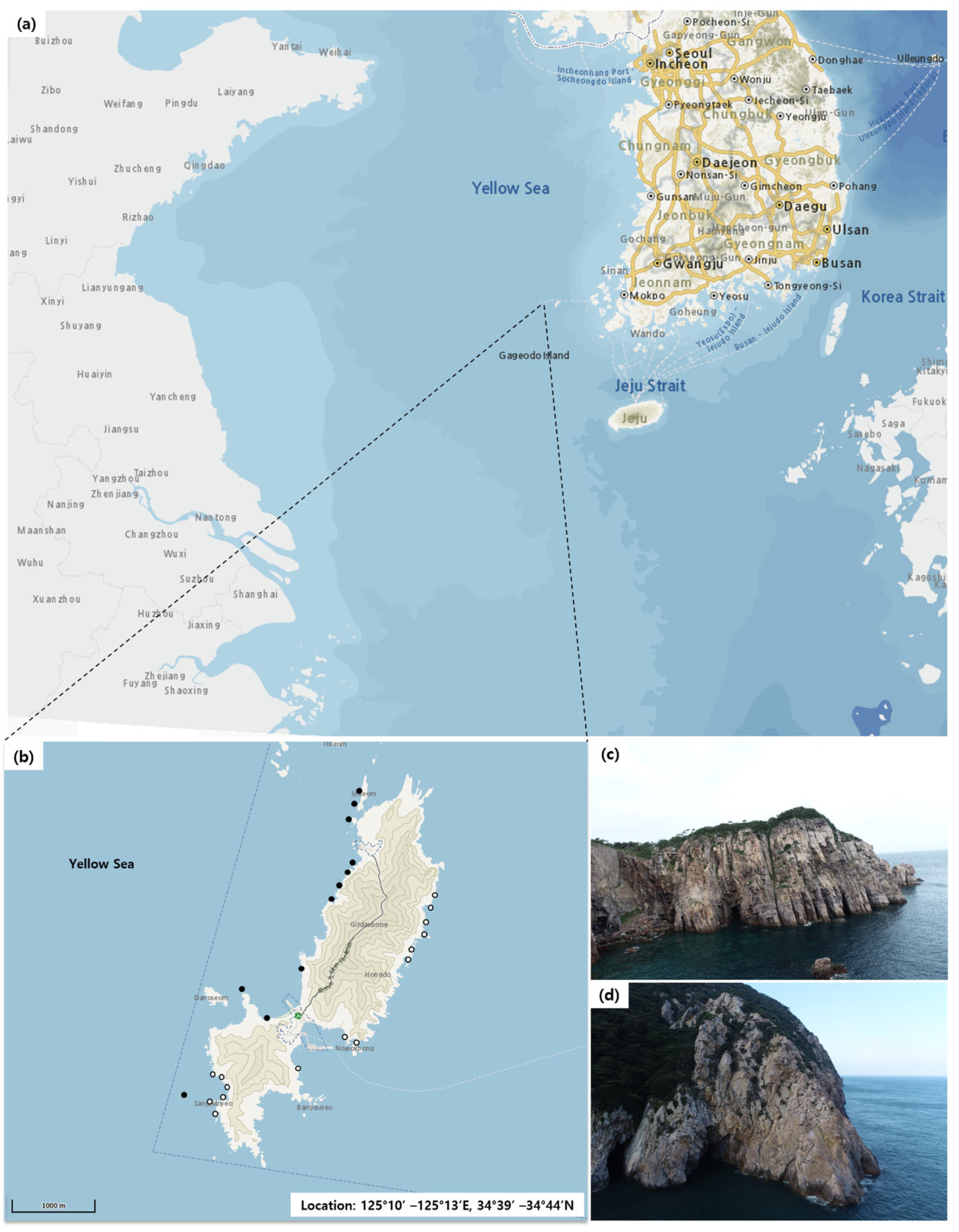
2.1. Study Area

The study area is Hongdo Natural Reserve (125°10′ –125°13′ E, 34°39′ –34°44′ N), an island of 6.5 km2 in Jeonnam Province, South Korea (Figure 1a,b). Hongdo has been preserved as a part of the Dadohaehaesang National Park in the country since 1981 and is isolated 110 km from the main Korean Peninsula. A mountain range continues between the southwestern and northeastern ends of the island (maximum altitude: 370 m), and rocky, steep cliff faces are developed along the coastline without shore plains (Figure 1c,d). Because of this topography, the northwestern aspect of the study area has a colder, drier microclimate due to the seasonal wind gust from the Siberian Anticyclone during winter, whereas the southeastern aspect has warmer conditions under the influences of the Kuroshio Current [27]. The climate of the study area is warm-temperate with precipitation and average air temperature of 1126.3 mm and 13.4 °C [28].
The forest canopy of the non-cliff lands of Hongdo Natural Reserve is generally dominated by evergreen broadleaved trees, including Castanopsis sieboldii, Neolitsea sericea, Quercus acuta, Machilus thunbergii, and Camellia japonica [28]. Previous observations have recorded 472 vascular flora taxa from the non-cliff, accessible area, among which, 4 taxa (Goodyera biflora, Damnacanthus major, Calanthe aristulifera, and Hemerocallis hongdoensis) are known to have the northern distributional limit at the study area [27]. There are 7 endangered, 9 Korea-endemic, and 40 alien plant species, classified by the Ministry of Environment of South Korea.

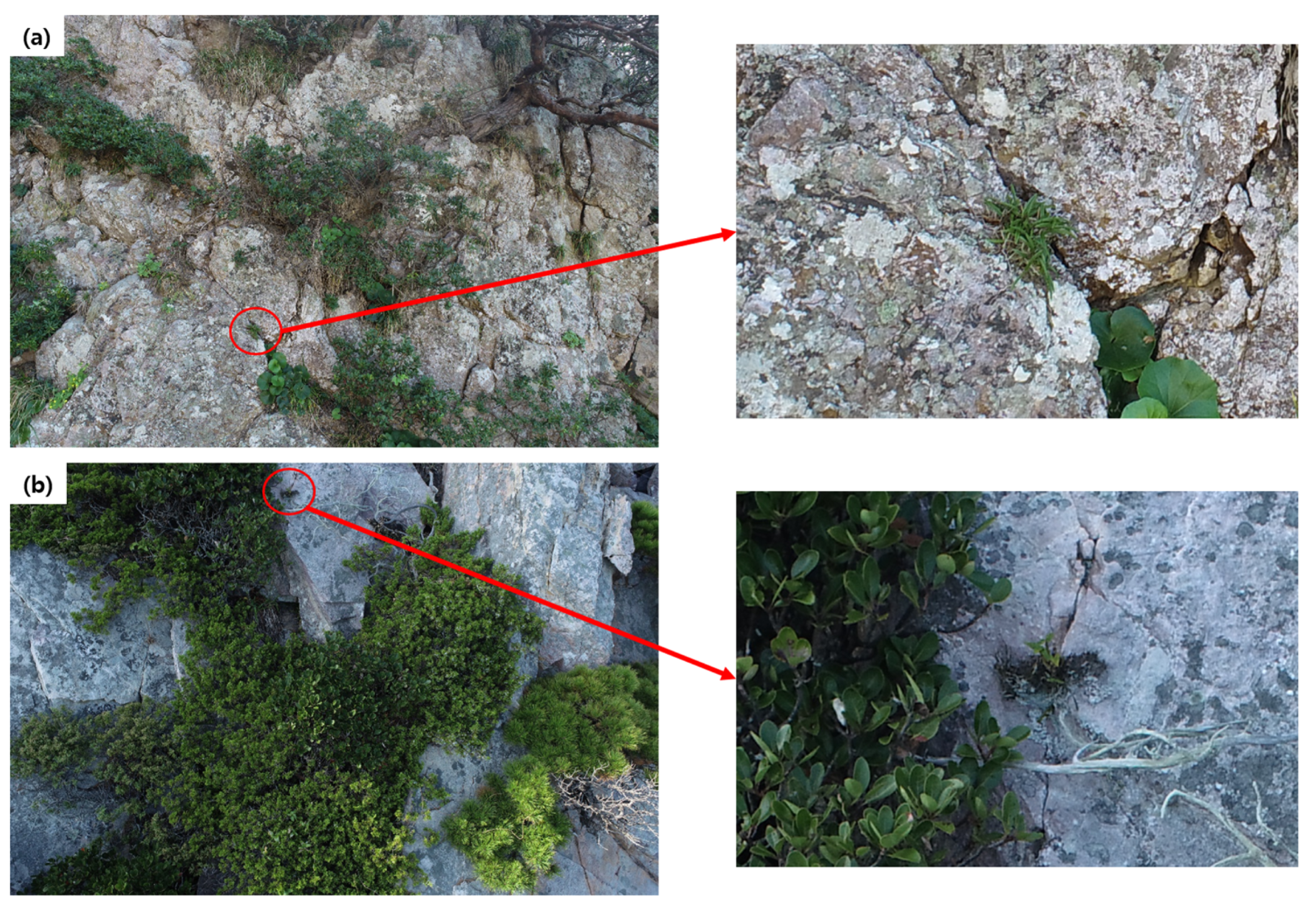
2.2. Study Design for UAV Data Acquisition

A total of 26 unreachable coastal cliffs were selected for the present study and subdivided into two cliff types based on aspect, namely, Type-N and Type-S (Table 1, Figure 1b). The Type-N cliffs face the northwestern aspect of the study area, where the cold, dry wind gust from the north directly affects the cliff vegetation during winter. Inversely, the Type-S cliffs face the southeastern aspect or are sheltered by the mountainous bay landscape, by which, such seasonal events during the winter become weakened. As UAV trials in the field should maintain a clear wireless signal under unstable air turbulence and complicated topography, our field data acquisition inevitably included an approach close to each coastal cliff from sea level using a ship. In this regard, any locations surrounded by severe ocean currents had to be avoided to ensure safety.
Image data were collected for each coastal cliff with a UAV (Phantom 4 pro V2.0, DJI, China) in May 2022. If the image from certain locations within the cliffs presented unidentifiable species, additional images were taken from the same locations again in August and October 2022 to find clearer morphological traits for those species. The camera of the used UAV system features a 20-megapixel sensor allowing the photogrammetry with a 5472 × 3648 pixel size. Our UAV data acquisition was based on the close-range photogrammetry protocol by Zhou et al. [14], but there were several adjustments considering the environments of the coastal cliffs (Figure 2a). First, photograph sampling was initiated from the lowest cliff point, where the UAV started to encounter any identifiable plant species (lowermost cliff location in Figure 2a), given that repetitive tidal impacts tended to create a non-vegetated buffer zone near the ocean surface. Second, the uppermost cliff location (Figure 2a) was defined as the highest edge between the cliff face and the cliff-top areas because the dense evergreen tree canopy did not allow the close-range UAV photogrammetry into forests on the cliff-top plains. Finally, multiple diagonal line transects (red dashed lines in Figure 2a) were used to move the UAV rather than a single vertical transect because our target coastal cliffs were generally wider compared to the pillar-shaped inland cliffs of Zhou et al. [14]. All UAV images were taken at a 1–2 m field of view from the cliff faces with at least 10 m sampling intervals.

2.3. Flora Taxa Identification and Categorization

The plant species in each UAV image were identified independently by three botanical experts familiar with the regional flora. Large plant species such as trees and shrubs were directly identifiable in each image, and the associated taxonomy could be specified (Figure 2b). Nonetheless, this direct approach was inapplicable for smaller herbs, epiphytes, and climbers, which correspondingly needed enlarged images for clear identification (Figure 2c). If any plants were impossible for such specific identification due to the absence of distinct morphological traits (e.g., fruits or flowers) during any of the three periods (May, August, and October), they were specified up to the genus level only (two taxa in the present study, Table S1 in the Supplementary Materials). Then, the results from the experts were integrated, and 1–3 dominant species were selected for each image on the basis of vegetation coverage (Figure 2b) [29]. When the experts reported contradictory identifications for a single species, those results would be compared with previous information from standard illustration books for Korean plants [30,31] and botanical specimen analyses regarding Hongdo Natural Reserve [27]. Each identified species was further categorized according to lifeform (trees, shrubs, climbers, epiphytes, or herbs; Cámara-Leret et al. [4]) and leaf longevity of woody species including trees and shrubs (deciduous or evergreen). Endangered, Korea-endemic, and alien species were informed based on the list by the Ministry of Environment. Nomenclature and taxonomy followed the international standards of the World Checklist of Selected Plant Families (WCSP) and the International Plant Names Index (IPNI) (Table S1).
Figure 2. Examples of line transects to acquire photogrammetry data with an unmanned aerial vehicle (a), the use of an acquired image to identify trees and shrubs on the cliff face (b), and an enlarged image for the detailed identification of small herb species (Aster spathulifolius) (c). The table next to panel (b) shows the list of tree and shrub species on the image.
Drones 07 00140 g002

2.4. Data Analysis

Incidence and dominance ratios were used to reflect floristic tendencies, in addition to the number of flora taxa. These ratios were estimated by the following equations [14]:
Incidence   ratio   % = I x I T o t a l × 100
Dominance   ratio   % = D x D T o t a l × 100
where Ix and Dx indicate the numbers of incidence and dominance of each species, and ITotal and DTotal mean the total number of incidence (total cliffs: 2582) and dominance (total cliffs: 396) of the plant species over the entire analyzed images, respectively. Here, incidence implies the total numbers of individuals for each plant species. The incidence was numbered once per image even when the given species occurred in multiple places within an image, considering the lack of belowground information to separate actual individuals [14]. The dominance represents the count of dominant species selected by the three botanical experts as per the vegetation coverage during the species identification procedure [29].
To test our first hypothesis, the number of the detected flora taxa was compared between the Type-N and Type-S cliff types (Table 1). The significance of the differences between the Type-N and Type-S cliffs was assessed by analysis of covariance with Tukey’s HSD test. This analysis used each studied coastal cliff as a unit of replication (α = 0.05, n = 11 for Type-N cliffs and 15 for Type-S cliffs) and cliff elevation as a covariate to minimize the potential confounding effects as a result of the inconsistent elevations within the same cliff type. The analyses were conducted with the agricolae and lsmeans packages in R 4.2.1. software (R Core Team, 2022). Then, the plant species were subdivided by whether they were detected in either the Type-N cliffs, the Type-S cliffs, or both, for which lifeform and leaf longevity groups were used to describe the floristic differences between the cliff types more in detail.
For our second hypothesis, a Pearson correlation test was conducted to describe the pairwise relationships between the cliff elevation and either the total number of flora taxa or the percentage of the species within each lifeform group relative to the total number of flora taxa (α = 0.05). Additionally, the number of flora taxa was compared between the uppermost and lowermost cliff locations using the generalized linear mixed model with Tukey’s HSD test (α = 0.05). This analysis included the cliff as a random effect (block) to deal with potential divergence among the individual coastal cliff sites. Both correlation and generalized linear mixed model treated each studied coastal cliff as a unit of replication (n = 26). The analyses were conducted with the lme4 package in R 4.2.1. software (R Core Team, 2022).

3. Results

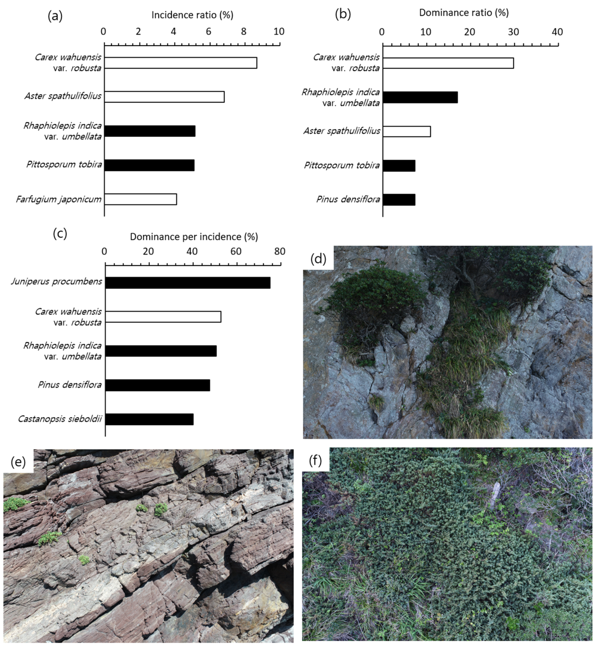
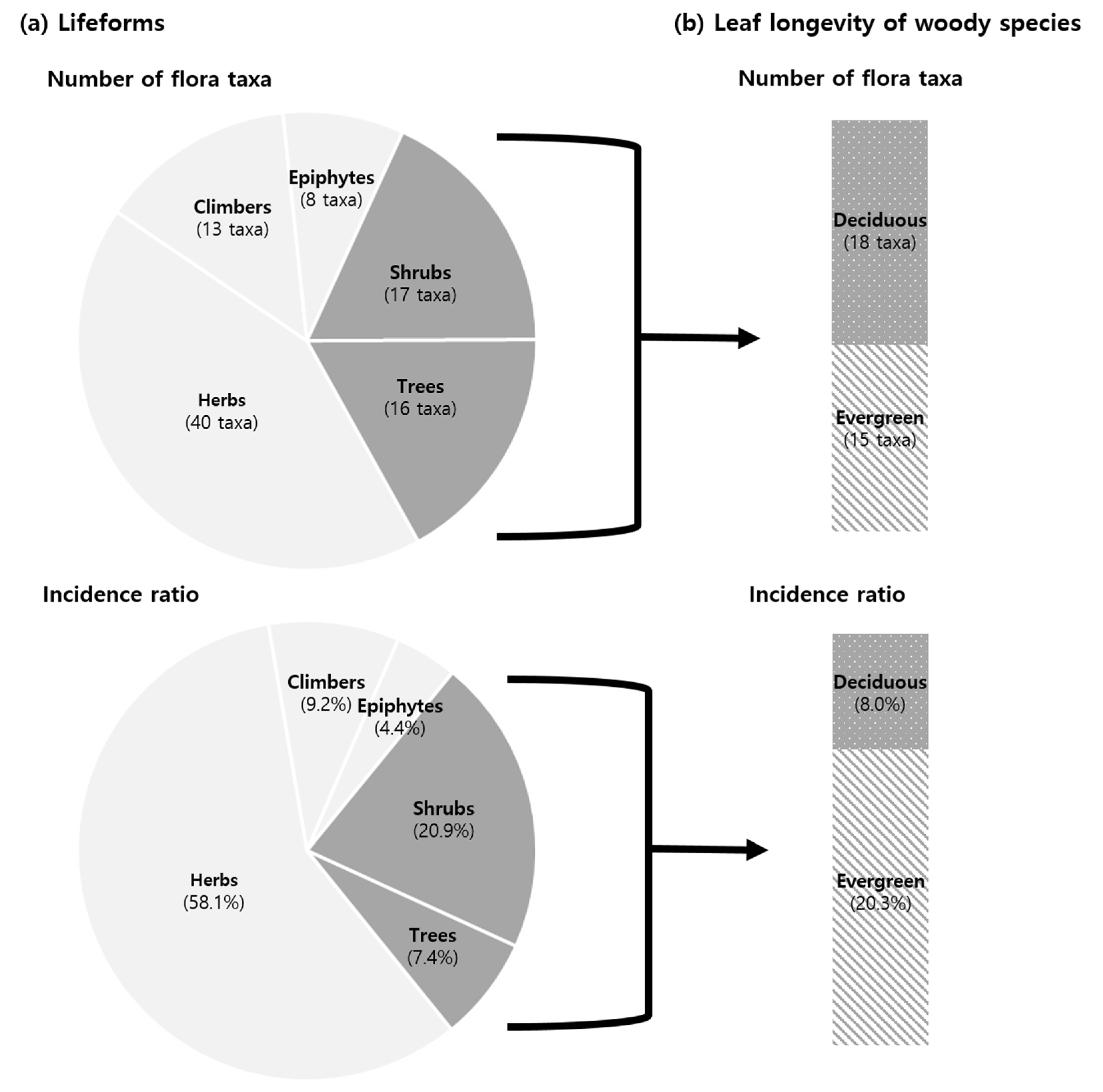
3.1. Coastal Cliff Flora Taxa, Incidence, and Dominance

A total of 94 flora taxa belonging to 46 families were detected from the studied coastal cliffs (Table S1). Asteraceae (10 taxa), Liliaceae (7 taxa), Poaceae (7 taxa), and Rosaceae (5 taxa) were the most widespread families, occupying 31% of the number of detected flora taxa and 47% of the flora incidence (total number of incidence: 2582). There were 2 endangered species (Dendrobium moniliforme and Neofinetia falcata, Figure A1), 4 Korea-endemic species (Hemerocallis hongdoensis, Hosta yingeri, Indigofera koreana, and Saussurea polylepis), and 2 alien species (Chenopodium ficifolium and Rumex crispus) among the 94 flora taxa.
Carex wahuensis var. robusta (8.7%), Aster spathulifolius (6.8%), Rhaphiolepis indica var. umbellata (5.2%), Pittosporum tobira (5.1%), and Farfugium japonicum (4.1%) exhibited the highest incidence ratio across the studied coastal cliffs (total number of incidence: 2582, Figure 3a). In total, 3 of them were herbs, whereas the others were shrubs. On the other hand, C. wahuensis var. robusta (29.8%), R. indica var. umbellata (16.9%), A. spathulifolius (10.9%), P. tobira (7.3%), and Pinus densiflora (7.3%) showed the highest dominance ratio (total number of dominance: 396, Figure 3b). These top 5 species for dominance ratio consisted of 2 herbs, 2 shrubs, and 1 tree species. Compared to the incidence ratio, the dominance ratio was more governed by the top 5 species (incidence ratio: 29.9%, dominance ratio: 72.2%). Juniperus procumbens featured a higher dominance per incidence than the top 5 species for incidence and dominance ratios (Figure 3c), reflecting its dense, creeping morphology on the cliff faces compared to C. wahuensis var. robusta, R. indica var. umbellata, and A. spathulifoliu (Figure 3d–f).
Lifeform grouping demonstrated that herbs (40 taxa, 58.1% incidence ratio) and epiphytes (8 taxa, 4.4% incidence ratio) were the most and least abundant lifeforms over the studied coastal cliffs, respectively (Figure 4a). The most abundant species for each lifeform were C. wahuensis var. robusta for herbs (incidence ratio: 8.7%, dominance ratio: 29.8%), R. indica var. umbellata for shrubs (incidence ratio: 5.2%, dominance ratio: 16.6%), P. densiflora for trees (incidence ratio: 2.4%, dominance ratio: 7.3%), Paederia foetida for climbers (incidence ratio: 2.6%, dominance ratio: 0.0%), and Sedum polytrichoides for epiphytes (incidence ratio: 2.4%, dominance ratio: 0.0%), respectively. Furthermore, leaf longevity grouping for woody species revealed that evergreen trees and shrubs (15 taxa, 20.3% incidence ratio) had a higher incidence ratio than deciduous trees and shrubs (18 taxa, 8.0% incidence ratio), despite their lower number of taxa (Figure 4b). The 15 evergreen species were mostly broadleaved trees and shrubs, except for two conifers (P. densiflora and J. procumbens). Elaeagnus macrophylla (incidence ratio: 1.4%, dominance ratio: 0.8%) and R. indica var. umbellata were the most widespread deciduous and evergreen species, respectively.

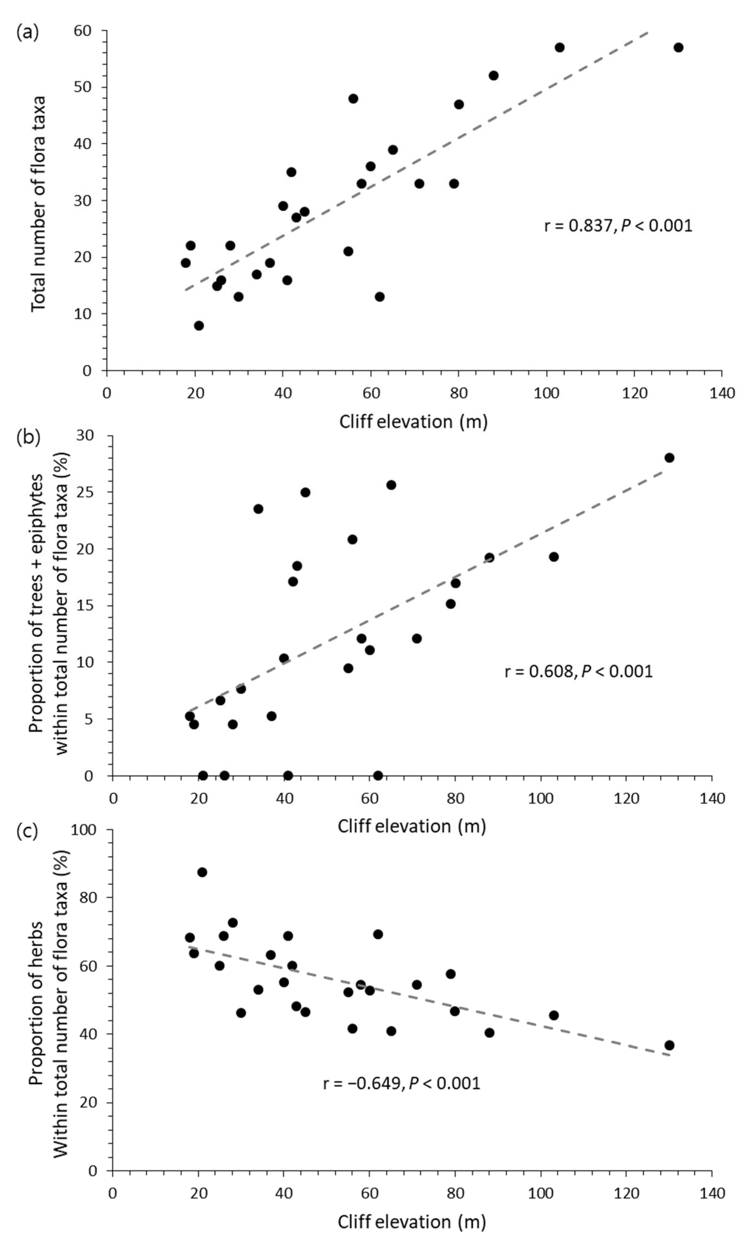
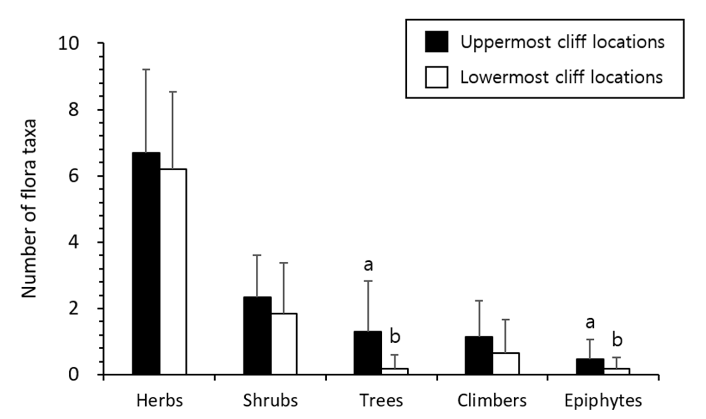
3.2. Patterns Related to Coastal Cliff Aspect and Elevation

The Type-N and Type-S cliffs contained 82 and 81 flora taxa, of which, 69 taxa occurred in both cliff types (Figure 5, Table S1). The analysis of covariance recorded that the Type-S cliffs tended to include a larger number of epiphyte species than the Type-N cliffs (p < 0.05), whereas no difference was significant for the other lifeform groups (Figure 5a). The Type-S cliffs also presented a smaller number of deciduous species (p < 0.01) but a larger number of evergreen species than the Type-N cliffs (p < 0.05) (Figure 5a). Considering the plant species found exclusively from either cliff type, the 13 taxa detected only in the Type-N cliffs consisted of 8 herbs, 2 shrubs, 2 climbers, and 1 tree species (Figure 5b). In contrast, the 12 taxa detected only in the Type-S cliffs comprised 4 epiphytes, 3 trees, 2 shrubs, 2 herbs, and 1 climber species (Figure 5c). Interestingly, half of the detected epiphyte species exclusively dwelled in the Type-S cliffs, whereas no epiphyte species was found in Type-N cliffs only. In other words, microhabitats in the Type-S cliffs might be more suitable for the occurrence of evergreen and epiphyte species than those in the Type-N cliffs.
Pearson correlation tests exhibited that the number of flora taxa increased with the elevation of the coastal cliffs (p < 0.001, Figure 6a). The proportion of tree and epiphyte species also increased with the cliff elevation (p < 0.001, Figure 6b); conversely, the proportion of herb species was negatively related to the elevation of coastal cliffs (p < 0.001, Figure 6c). On the other hand, the generalized linear mixed model demonstrated that the uppermost cliff locations tended to contain a larger number of tree and epiphyte species than the lowermost cliff locations (p < 0.05, Figure 7); inversely, the differences in herb, shrub, and climber species were not significant (Figure 7). These results imply that a higher elevation of coastal cliffs might encourage the occurrence of trees and epiphytes against the abundance of herb species under lower cliff elevation conditions.

4. Discussion

Before discussing our primary hypotheses, it is worth noting that the UAV-based explorations can reflect several floristic characteristics of coastal cliffs contrasting with non-cliff sites. For example, the studied coastal cliffs presented approximately 19.9% of the plant species recorded from the non-cliff lands around the study area (472 flora taxa) by Jang et al. [27], with a higher proportion of endangered and Korea-endemic species (coastal cliffs: 6.4%, non-cliffs: 3.4%) but a lower proportion of alien species (coastal cliffs: 2.1%, non-cliffs: 8.5%). Particularly, the endangered orchid, Neofinetia falcata, has been undetected in the study area since 2014 until our detection (Figure A1a) [27], suggesting that the harsh, unstable environments of coastal cliffs could contribute to sheltering rare, endangered plants from the invasion of non-native, competitive species and anthropogenic land use changes [7]. Our results also show that plant communities along coastal cliffs were frequently dominated by salt- and dry-tolerant shrubs and herbs (e.g., Rhaphiolepis indica var. umbellata, Aster spathulifolius, and Pittosporum tobira), even though the neighboring non-cliff sites comprised terrestrial, mountainous forests with dense tree canopies (e.g., Castanopsis sieboldii, Neolitsea sericea, and Quercus acuta) [28]. These floristic differences support the importance of UAV-based approaches toward the inaccessible cliffs to totally understand the structure and biodiversity throughout coastal ecosystems.

4.1. Floristic Variabilities under Differing Coastal Cliff Aspect and Elevation

Aspect-related variations in microclimates are regarded as one of the principal mechanisms controlling the composition, function, and morphology of plant communities [14,32]. Here, the two coastal cliff types were distinguishable in terms of the occurrence and composition of the detected plant species. The results especially show that the Type-S cliffs retained a higher number of epiphyte species than the Type-N cliffs, and four out of eight epiphyte taxa were recorded exclusively in the Type-S cliffs. This pattern might occur because many epiphyte species in the temperate zone rely on the atmospheric moisture availability in warm, humid microhabitats [33]; therefore, the colder, drier microclimate over the winter season could discourage the survival and growth of epiphytes in the Type-N cliffs relative to the Type-S cliffs [27]. A similar difference was also found in the leaf longevity grouping for woody species, in which the Type-N cliffs featured a significantly larger number of deciduous tree and shrub species but a lower number of evergreen species than the Type-S cliffs. In fact, geographical and climatic gradients are the most critical factors determining the distribution of deciduous and evergreen plants, and evergreen broadleaved species are vulnerable to extreme cold events in warm temperate or subtropical areas [34]. Although the study area might be too small to reflect the latitudinal or altitudinal gradients in the microclimate, the direct, seasonal exposure of the Type-N cliffs to the northern Siberian Anticyclone might enhance the aspect-related differences in the microclimate and the associated floristic structure [27]. Given that most of the detected evergreen species were broadleaved, the different occurrences between the evergreen and deciduous species might fit into such explanations. Overall, our findings assist the first hypothesis on the floristic variations between the coastal cliff aspects under differing exposures to the cold, dry conditions during the winter season.
Other evidence affirms our second hypothesis about the relationship between coastal cliff elevation and plant diversity. For instance, the number of flora taxa was positively related to the elevation of the study’s coastal cliffs, similar to reports from previous UAV applications to inland cliff ecosystems [14]. These patterns might occur as the high elevation of coastal cliffs potentially leads to a wider surface area and heterogeneous topography available for diverse plant species to survive [25]. In addition to this general pattern, our findings unveil the notable alterations in plant community composition following the variation in coastal cliff elevation. Whereas plant communities in the lower coastal cliffs showed an increased proportion of herb species, those in the higher coastal cliffs had more complex lifeform compositions resulting from the elevated proportion of trees and epiphytes. Moreover, the uppermost cliff locations presented more tree and epiphyte species than the lowermost cliff locations within each studied coastal cliff. In fact, the bottom area of the coastal cliffs is subjected to more unstable environments compared to the top area because of the stronger tidal impact and the salt spray from the ocean surface and accelerated soil erosions [35,36]. Such a situation at the bottom of the coastal cliffs possibly reduces the fitness of the plant species that require stable habitat environments and long-term growing periods for reproduction [5,37]. This explanation supports the results of Strumia et al. [7], who found a marked difference in habitat preference depending on plant species along the elevation within a coastal cliff site. Given that the high elevation of coastal cliffs provides additional upper locations unreachable for direct tidal waves [38,39], the higher coastal cliffs could retain more trees and attached epiphytes vulnerable to extremely unstable conditions than the lower coastal cliffs.

4.2. Implications and Future Research Requirements

Information on coastal cliff vegetation remained unclear for decades as a result of its inherent inaccessibility. In this context, the plant ecology of the untouched, unreachable coastal cliffs traditionally depended on estimations using data from other accessible cliff sites [1,3,5,6,9,40,41]. As one of the initial UAV applications for coastal cliff vegetation [7], the present study emphasizes the potential usability of UAV photogrammetry to address ecological questions regarding plant communities of inaccessible coastal cliffs more than mere plant species identification. Our findings verify the topographic effects on the structure and composition of plant communities under harsh, unstable environments beyond indirect speculations relying on the traditionally accessible sites only.
Despite the UAV’s usability for coastal cliff studies, several challenges still require additional research attention and technological innovations. First of all, individuals without clear morphological traits are difficult for image-based species identification [14]. The combination of UAV and sampling manipulators may be an alternative to overcome this uncertainty through direct sampling and botanical specimen analysis in the field [15]. Secondly, UAV investigations for varying coastal cliffs can be confounded by heterogeneous image quality because poor light conditions at the north-facing cliffs inevitably increase blurred and noisy photographs [7]; in this regard, future UAV-based approaches may consider the use of AI-aided object detection to help ensure accuracy under such challenging environments [13,42]. The attachment of the improved telephoto lens may also be useful to solve the limitation of close-range UAV photogrammetry for sites under tree branches and other blocking objects [43]. Last but not least, multispectral and other types of remote sensors should be piloted so that UAV-based studies can cover wider topics such as plant ecophysiology and carbon cycles in unreachable coastal cliffs [21]. Given that such techniques have already played a remarkable role in the understanding of relatively stable, inland plant communities [20], similar implementations will allow the testing of broader research designs and hypotheses under harsh, challenging ecosystems in the near future.

5. Conclusions

The present study unveils the potential applicability of close-range UAV photogrammetry to deal with ecological questions regarding plant communities of unreachable coastal cliffs. Our results demonstrate that the floristic structure of coastal cliffs closely corresponded to the cliff aspect and elevation controlling the magnitude of cold, dry conditions during winter and tidal impacts from the ocean surface. Particularly, northwest-facing coastal cliffs contained more deciduous species but fewer epiphytes and evergreen species than coastal cliffs under other aspect conditions. There were alterations in plant species compositions (especially related to trees and epiphytes) along the gradients of the coastal cliff elevation as well as increases in the total number of detected plant species. Comparisons with previous datasets for non-cliff areas also suggest that the harsh environments around coastal cliffs potentially shelter rare, endangered plants from the invasion of alien, competitive species and anthropogenic interventions. Further research on coastal cliff flora may consider the adaptation of AI-aided object detection, sampling manipulator, telephoto lens, and multispectral sensor technologies to extend the usefulness of UAV systems. As such, technologies already contributing to investigating relatively stable, inland plant communities, and similar applications will be able to diversify experimental designs and hypotheses for exploring inaccessible coastal cliffs near future. We hope that our UAV-based explorations will aid to broaden the insights into coastal cliff ecosystems that still remain challenging and least known in plant ecology.

Supplementary Materials

The following supporting information can be downloaded at: https://www.mdpi.com/article/10.3390/drones7020140/s1, Table S1: List of flora taxa detected in each cliff type of the study area. Extra information includes endangered species (by the Ministry of Environment of South Korea: EN), Korea-endemic species (KE), and alien species (AL) data. The word “sp.” indicates the taxa classified only up to the genus level.

Author Contributions

Conceptualization, S.K. and C.W.L.; methodology, S.K. and C.W.L.; software, C.W.L.; formal analysis, S.K. and C.W.L.; investigation, S.K., C.W.L., H.-J.P., and B.-D.L.; resources, C.W.L. and N.Y.K.; data curation, S.K., C.W.L., and H.-J.P.; writing—original draft preparation, S.K.; writing—review and editing, C.W.L., B.-D.L., J.E.H., H.B.P., J.A., and J.B.; visualization, S.K. and C.W.L.; supervision, C.W.L. and N.Y.K.; project administration, C.W.L. and N.Y.K.; funding acquisition, N.Y.K. All authors have read and agreed to the published version of the manuscript.

Funding

This study was supported by a research grant from the National Institute of Ecology (grant number: NIE-B-2023-49) of South Korea.

Data Availability Statement

The data used for the present study can be sought in the figures, tables, and supporting information. The data can be made available from the corresponding author.

Acknowledgments

We especially thank Hong-Jo Hwang, who helped to select the coastal cliff sites and safely utilize the ship.

Conflicts of Interest

The authors approve that there are no conflicts of interest potentially affecting the findings of the present study.

Appendix A

Figure A1. UAV photographs of the endangered orchid species from the studied coastal cliffs: Neofinetia falcata (a) and Dendrobium moniliforme (b).
Drones 07 00140 g0a1

References

  1. Goldsmith, F.B. Interaction (competition) studies as a step towards the synthesis of sea-cliff vegetation. J. Ecol. 1978, 66, 921–931. [Google Scholar] [CrossRef]
  2. Panitsa, M.; Kokkoris, I.P.; Kougioumoutzis, K.; Kontopanou, A.; Bazos, I.; Strid, A.; Dimopoulos, P. Linking taxonomic, phylogenetic and functional plant diversity with ecosystem services of cliffs and screes in Greece. Plants 2021, 10, 992. [Google Scholar] [CrossRef] [PubMed]
  3. Wilson, J.B.; Cullen, C. Coastal cliff vegetation of the Catlins region Otago, South Island, New Zealand. New Zealand J. Bot. 1986, 24, 567–574. [Google Scholar] [CrossRef]
  4. Cámara-Leret, R.; Frodin, D.G.; Adema, F.; Anderson, C.; Appelhans, M.S.; Argent, G.; Guerrero, S.A.; Ashton, P.; Baker, W.J.; Barfod, A.S.; et al. New Guinea has the world’s richest island flora. Nature 2020, 584, 579–583. [Google Scholar] [CrossRef]
  5. Jung, S.H.; Kim, A.R.; Lim, B.S.; Seol, J.W.; Lee, C.S. Spatial distribution of vegetation along the environmental gradient on the coastal cliff and plateau of Janggi peninsular (Homigot), southeastern Korea. J. Ecol. Environ. 2019, 43, 14. [Google Scholar]
  6. Caperta, A.D.; Espírito-Santo, M.D.; Silva, V.; Ferreira, A.; Paes, A.P.; Róis, A.S.; Costa, J.C.; Arsénio, P. Habitat specificity of a threatened and endemic, cliff-dwelling halophyte. AOB Plants 2014, 6, plu032. [Google Scholar] [CrossRef] [Green Version]
  7. Strumia, S.; Buonanno, M.; Aronne, G.; Santo, A.; Santangelo, A. Monitoring of plant species and communities on coastal cliffs: Is the use of unmanned aerial vehicles suitable? Diversity 2020, 12, 149. [Google Scholar] [CrossRef] [Green Version]
  8. Davis, P.H. Cliff vegetation in the eastern Mediterranean. J. Ecol. 1951, 39, 63–93. [Google Scholar] [CrossRef]
  9. Randall, R.E. Vegetation and environment on the Barbados coast. J. Ecol. 1970, 58, 155–172. [Google Scholar] [CrossRef]
  10. Boggess, L.M.; Walker, G.L.; Madritch, M.D. Cliff flora of the Big South Fork National River and Recreation Area. Nat. Areas J. 2017, 37, 200–211. [Google Scholar] [CrossRef]
  11. Covy, N.; Benedict, L.; Keeley, W.H. Rock climbing activity and physical habitat attributes impact avian community diversity in cliff environments. PLoS ONE 2019, 14, e0209557. [Google Scholar] [CrossRef]
  12. March-Salas, M.; Moreno-Moya, M.; Palomar, G.; Tejero-Ibarra, P.; Haeuser, E.; Pertierra, L.R. An innovative vegetation survey design in Mediterranean cliffs shows evidence of higher tolerance of specialized rock plants to rock climbing activity. Appl. Veg. Sci. 2018, 21, 289–297. [Google Scholar] [CrossRef]
  13. Reckling, W.; Mitasova, H.; Wegmann, K.; Kauffman, G.; Reid, R. Efficient drone-based rare plant monitoring using a species distribution model and AI-based object detection. Drones 2021, 5, 110. [Google Scholar] [CrossRef]
  14. Zhou, H.; Zhu, J.; Li, J.; Xu, Y.; Li, Q.; Yan, E.; Zhao, S.; Xiong, Y.; Mo, D. Opening a new era of investigating unreachable cliff flora using smart UAVs. Remote Sens. Ecol. Conserv. 2021, 7, 638–648. [Google Scholar] [CrossRef]
  15. La Vigne, H.; Charron, G.; Rachiele-Tremblay, J.; Rancourt, D.; Nyberg, B.; Desbiens, A.L. Collecting critically endangered cliff plants using a drone-based sampling manipulator. Sci. Rep. 2022, 12, 14827. [Google Scholar] [CrossRef]
  16. Li, M.; Yan, E.; Zhou, H.; Zhu, J.; Jiang, J.; Mo, D. A novel method for cliff vegetation estimation based on the unmanned aerial vehicle 3D modeling. Front. Plant Sci. 2022, 13, 1006795. [Google Scholar] [CrossRef]
  17. Duffy, J.P.; Cunliffe, A.M.; DeBell, L.; Sandbrook, C.; Wich, S.A.; Shutler, J.D.; Myers-Smith, I.H.; Varela, M.R.; Anderson, K. Location, location, location: Considerations when using lightweight drones in challenging environments. Remote Sens. Ecol. Conserv. 2018, 4, 7–19. [Google Scholar] [CrossRef]
  18. Kim, S.; Park, H.J.; Lee, C.W.; Kim, N.Y.; Hwang, J.E.; Lee, B.D.; Park, H.B.; An, J.; Baek, J.H. Endangered plant species under differing anthropogenic interventions: How to preserve Pterygopleurum neurophyllum in Wondong wetland? PeerJ 2022, 10, e14050. [Google Scholar] [CrossRef]
  19. Rominger, K.R.; DeNittis, A.; Meyer, S.E. Using drone imagery analysis in rare plant demographic studies. J. Nat. Conserv. 2021, 62, 126020. [Google Scholar] [CrossRef]
  20. Sun, Z.; Wang, X.; Wang, Z.; Yang, L.; Xie, Y.; Huang, Y. UAV as remote sensing platforms in plant ecology: Review of applications and challenges. J. Plant Ecol. 2021, 14, 1003–1023. [Google Scholar] [CrossRef]
  21. Villoslada, M.; Bergamo, T.F.; Ward, R.D.; Burnside, N.G.; Joyce, C.B.; Bunce, R.G.H.; Sepp, K. Fine scale plant community assessment in coastal meadows using UAV based multispectral data. Ecol. Indic. 2020, 111, 105979. [Google Scholar] [CrossRef]
  22. Clark, A.; Moorman, B.; Whalen, D.; Fraser, P. Arctic coastal erosion: UAV-SfM data collection strategies for planimetric and volumetric measurements. Arct. Sci. 2021, 7, 605–633. [Google Scholar] [CrossRef]
  23. Gilham, J.; Barlow, J.; Moore, R. Detection and analysis of mass wasting events in chalk sea cliffs using UAV photogrammetry. Eng. Geol. 2019, 250, 101–112. [Google Scholar] [CrossRef] [Green Version]
  24. Kong, X. Identifying geomorphological changes of coastal cliffs through point cloud registration from UAV. Remote Sens. 2021, 13, 3152. [Google Scholar] [CrossRef]
  25. Irl, S.D.H.; Harter, D.E.V.; Steinbauer, M.J.; Puyol, D.G.; Fernández-Palacios, J.M.; Jentsch, A.; Beierkuhnlein, C. Climate vs. topography—Spatial patterns of plant species diversity and endemism on a high-elevation island. J. Ecol. 2015, 103, 1621–1633. [Google Scholar] [CrossRef]
  26. Boggess, L.M.; Harrison, G.R.; Bishop, G. Impacts of rock climbing on cliff vegetation: A methods review and best practices. Appl. Veg. Sci. 2021, 24, e12583. [Google Scholar] [CrossRef]
  27. Jang, Y.J.; Park, J.S.; Lee, J.S.; Lee, J.Y.; Choi, B.-H. Re-examination of the vascular plants on Hongdo Island, Korea. Korean J. Plant Taxon. 2021, 52, 205–249, (In Korean with English Abstract). [Google Scholar] [CrossRef]
  28. Kim, H.J.; Shin, J.K.; Lee, C.H.; Yun, C.W. Phytosociological community type classification and stand structure in the forest vegetation of Hongdo Island, Jeollanam-do Province. J. Korean Soc. For. Sci. 2018, 107, 245–257, (In Korean with English Abstract). [Google Scholar]
  29. Braun-Blanquet, J. Plant Sociology. The Study of Plant Communities; McGraw-Hill Book Co., Inc.: New York, NY, USA, 1932; p. 439. [Google Scholar]
  30. Lee, W.T. Standard Illustrations of Korean Plants; Academy Press: Seoul, Republic of Korea, 1996; p. 624. (In Korean) [Google Scholar]
  31. Lee, T.B. Coloured Flora of Korea; Hyangmun Publ. Co., Ltd.: Seoul, Republic of Korea, 2003; p. 1928. (In Korean) [Google Scholar]
  32. Noh, N.J.; Son, Y.; Koo, J.W.; Seo, K.W.; Kim, R.H.; Lee, Y.Y.; Yoo, K.S. Comparison of nitrogen fixation for north- and south-facing Robinia pseudoacacia stands in central Korea. J. Plant Biol. 2010, 53, 61–69. [Google Scholar] [CrossRef]
  33. Zotz, G.; Hietz, P. The physiological ecology of vascular epiphytes: Current knowledge, open questions. J. Exp. Bot. 2001, 52, 2067–2078. [Google Scholar] [CrossRef]
  34. Ge, J.; Xie, Z. Geographical and climatic gradients of evergreen versus deciduous broad-leaved tree species in subtropical China: Implications for the definition of the mixed forest. Ecol. Evol. 2017, 7, 3636–3644. [Google Scholar] [CrossRef]
  35. Earlie, C.; Masselink, G.; Russell, P. The role of beach morphology on coastal cliff erosion under extreme waves. Earth Surf. Process. Landf. 2018, 43, 1213–1228. [Google Scholar] [CrossRef] [Green Version]
  36. Alessio, P.; Keller, E.A. Short-term patterns and processes of coastal cliff erosion in Santa Barbara, California. Geomorphology 2020, 353, 106994. [Google Scholar] [CrossRef]
  37. Bergillos, R.J.; Rodriguez-Delgado, C.; Cremades, J.; Medina, L.; Iglesias, G. Multi-criteria characterization and mapping of coastal cliff environments: A case study in NW Spain. Sci. Total Environ. 2020, 746, 140942. [Google Scholar] [CrossRef]
  38. Lee, E.M. Coastal cliff behaviour: Observations on the relationship between beach levels and recession rates. Geomorphology 2008, 101, 558–571. [Google Scholar] [CrossRef]
  39. Kogure, T. Rocky coastal cliffs reinforced by vegetation roots and potential collapse risk caused by sea-level rise. Catena 2022, 217, 106457. [Google Scholar] [CrossRef]
  40. Peña-Lastra, S.D.L.; Gómez-Rodríguez, C.; Pérez-Alberti, A.; Torre, F.; Otero, X.L. Effects of a yellow legged gull (Larus michahellis) colony on soils and cliff vegetation in the Atlantic Island of Galicia National Park (NW Spain). Catena 2021, 199, 105115. [Google Scholar] [CrossRef]
  41. Sawtschuk, J.; Bioret, F.; Gallet, S. Spontaneous succession as a restoration tool for maritime cliff-top vegetation in Brittany, France. Restor. Ecol. 2010, 18, 273–283. [Google Scholar] [CrossRef]
  42. Augusto, J.; Martins, C.; Marcato Junior, J.; Pätzig, M.; Sant’Ana, D.A.; Pistori, H.; Liesenberg, V.; Eltner, A. Identifying plant species in kettle holes using UAV images and deep learning techniques. Remote Sens. Ecol. Conserv. 2022. Published online. [Google Scholar] [CrossRef]
  43. Niwa, H.; Hirata, T. A new method for surveying the world’s smallest class of dragonfly in wetlands using unoccupied aerial vehicles. Drones 2022, 6, 427. [Google Scholar] [CrossRef]
Figure 1. Geographic location of the study area (a,b) and examples of the studied coastal cliffs (c,d). Black and white dots in panel (b) demonstrate Type-N and Type-S cliffs, respectively. The maps used for panels (a,b) are acquired from the open source platform by the National Geographic Information Institute of South Korea (https://www.ngii.go.kr/eng/main.do, accessed on 8 February 2023).
Drones 07 00140 g001
Figure 3. Summary for the major plant species of the studied coastal cliffs: incidence ratio (a), dominance ratio (b), dominance per incidence (c), and typical cliff habitats of Carex wahuensis var. robusta and Rhaphiolepis indica var. umbellata (d), Aster spathulifolius (e), and Juniperus procumbens (f). The black and white colors of the bars in the panels (ac) indicate woody (trees and shrubs) and herbaceous (herbs, climbers, and epiphytes) species, respectively. The incidence and dominance ratios were calculated based on the proportion of the counted plant individuals for each species relative to the total number of the counted individuals across all studied coastal cliffs (n = 2582 for incidence and 396 for dominance).
Drones 07 00140 g003
Figure 4. Number of flora taxa and incidence ratio across the studied coastal cliffs, summarized based on lifeform (a) and the leaf longevity of woody species (i.e., trees and shrubs) (b). The light and dark gray colors of the panel (a) indicate herbaceous and woody species, respectively. The incidence ratio was calculated based on the proportion of the counted plant individuals for each group relative to the total number of the counted plant individuals across all studied coastal cliffs (n = 2582).
Drones 07 00140 g004
Figure 5. Comparisons between Type-N and Type-S cliffs: difference in flora taxa between the cliff types according to analysis of covariance (a), and composition of plant species detected exclusively in either the Type-N cliffs (b) or the Type-S cliffs (c). The light and dark gray colors of the pie graphs in panels (b) and (c) indicate herbaceous and woody species, respectively. The error bars in panel (a) represent standard error values, and the lowercased letters on the bars indicate statistically significant differences between the cliff types within each group in accordance with Tukey’s HSD test (α = 0.05, n = 11 for the Type-N cliffs and 15 for the Type-S cliffs).
Drones 07 00140 g005
Figure 6. Pairwise relationships of coastal cliff elevation with the total number of flora taxa (a), the proportion of trees plus epiphyte taxa compared to the total number of flora taxa (b), and the proportion of herb taxa compared to the total number of flora taxa (c) across the studied coastal cliffs (α = 0.05, n = 26). Here, the term “herb” implies herbaceous, ground-dwelling plant species except for climbers and epiphytes.
Drones 07 00140 g006
Figure 7. Comparisons between the number of flora taxa between the uppermost and lowermost cliff locations based on the generalized linear mixed model. The error bars inform standard error values. The letters on the bars show statistically significant differences between the locations within each lifeform group in accordance with Tukey’s HSD test (α = 0.05, n = 26).
Drones 07 00140 g007
Table 1. Information on the studied coastal cliff types.
Cliff TypeCharacteristicsNumber of CliffsCliff Elevation (m)
Average aMinimumMaximum
Type-NDirectly exposed to cold, dry wind gusts in winter (northwestern aspect of the study area)1155 (28)18103
Type-SSheltered from the wind gust in winter (facing southeast or surrounded by the mountainous bay)1550 (22)28130
a Values in parentheses indicate standard errors.
Disclaimer/Publisher’s Note: The statements, opinions and data contained in all publications are solely those of the individual author(s) and contributor(s) and not of MDPI and/or the editor(s). MDPI and/or the editor(s) disclaim responsibility for any injury to people or property resulting from any ideas, methods, instructions or products referred to in the content.

