1. Introduction
Agriculture is one of the most susceptible sectors to climate change [
1], with livestock production being the most climate sensitive economic area [
2]. Climate change may adversely affect various aspects of livestock production systems including animal health and productivity, fodder production, water availability, pests, and diseases [
3]. The livestock sector—an integral part of the mixed farming system of Nepal—is facing adverse impacts from climate variability and extremes [
4,
5]. Smallholder farmers with low income are a large and particularly vulnerable group. Precipitation analysis indicates that there has been a tendency toward more frequent and intense droughts during the dry season over the past decades in the Gandaki River Basin (GRB) region of central Nepal [
5,
6]. Western Nepal has also experienced consecutive and worsening winter droughts since 2000, culminating in a severe drought episode during 2008–09 [
7]. The summer monsoon (June–September) is the main rainy season, contributing around 80% of the annual rainfall. However, the spatial and temporal distribution of monsoon rainfall in the region has become erratic in recent years [
6,
7,
8,
9]. As most agriculture in Nepal is rain-fed, these changes pose a significant threat to agricultural production.
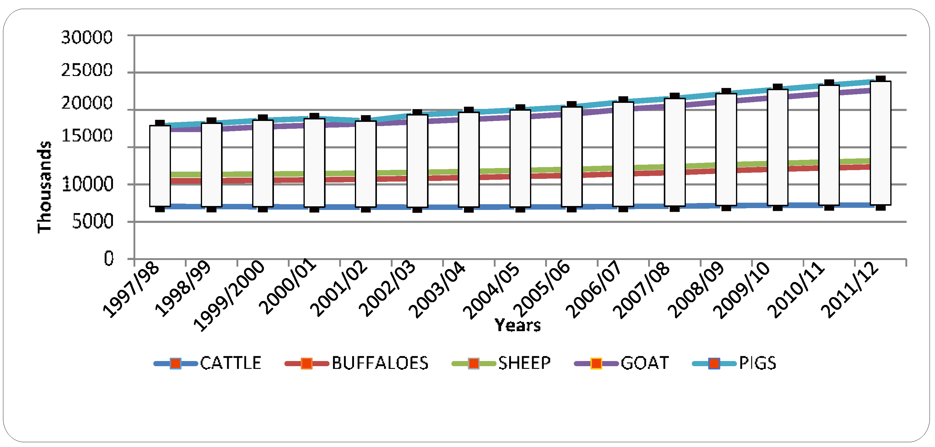
The topography of Nepal is rugged, and although large rivers frequently cause flooding events, insufficient water for farming often occurs due to lack of infrastructure for water storage and irrigation. Rainfed cultivation and traditional irrigation have served farms and farmers well in the past. Water applied using these systems supported the growth of annual and perennial fodders, yielding a cost effective production system. In recent years, rising temperatures, more variation in summer and winter temperature, erratic rainfall, and prolonged droughts, along with steady growth in human and livestock populations (
Figure 1), have resulted in reduced supply and increased cost of irrigation water and other pressures on perennial pastures, forcing farmers to consider alternative land uses and irrigation systems [
10]. This has created an increased reliance on annual crops and fodders purchased from outside the farm at higher cost compared to home-grown feed to fill feed gaps.
Figure 1.
Trends in population of major livestock species in Nepal [
11].
Figure 1.
Trends in population of major livestock species in Nepal [
11].
Furrow irrigation is the dominant method of water delivery in Nepal. Furrow irrigation, a system where water is transferred from a head ditch to crop furrows via siphons, is one of the simplest and most ancient forms of irrigation delivery [
12]. It can achieve reasonable irrigation efficiency (IE), although this can be highly variable. The efficiency of furrow irrigation is affected by field slope and length, and by water infiltration rates. Control of the rate of irrigation application and reduction in drainage beyond the root zone is difficult. With water delivered by inundation of furrows, waterlogging is common [
13]. In slopes, a greater amount of water is supplied to the upper portion of the field, which increases deep water drainage beyond the root zone, depriving the root zones of plants at the lower end of the field of full recharge. Heavy or prolonged water application can result in excessive runoff, while low rates of application tend to result in slow water advance, causing poor water distribution and deep drainage losses. Soil type and heterogeneity in infiltration rates both across and down the field also affect the efficiency of furrow irrigation. Soil crusting can be problematic in furrow irrigation systems, as soil slaking can result in bed deformation and slumping. Tail water losses, deep drainage, and evaporative and drainage losses from irrigation channels constitute predominant water losses from furrow irrigation systems. Furrow irrigation, although inherently limited, is a reliable and flexible system that can be managed to achieve reasonable IE. Furthermore, such a system encourages deeper crop rooting depths that utilize water from the entire soil profile.
Compared to furrow systems, drip irrigation can substantially improve water use efficiency (WUE) by minimizing evaporative loss of water and maximizing capture of in-season rainfall by the soil profile [
14]. The main disadvantage of drip irrigation systems is the cost of installation and maintenance. Historically, irrigation scheduling in drip irrigation systems has proved to be slightly more difficult than for other irrigation delivery methods [
15,
16]. Nevertheless, drip irrigation can help satisfy the demands associated with increased pressures of growers to increase WUE and maximize production [
15].
Precipitation in mountain regions is often highly variable, and efficient irrigation is the best approach for managing limited water supplies and irregular precipitation events. Surface drip irrigation slowly releases water directly to the roots of crops, saving 60%–70% in water consumption and reducing the chance of disease infestation as waterlogged plants are susceptible to fungal and other diseases [
17]. This system of irrigation keeps the topsoil layer moist but not excessively wet, and can be used to provide the exact amount of water required to the plants [
18]. One of the major challenges faced by livestock farmers in Nepal is obtaining fodder due to lack of rainfall and water availability outside the monsoon season. We propose that this problem can be minimized by adopting efficient irrigation technologies [
18,
19], such as drip irrigation, for cultivating nutritious fodder varieties during the dry season.
In the small farming system, IE is the fraction of water applied that is available to the crop, in the crop root zone, for uptake. Nutrients such as nitrogen (N), phosphorus (P) and potassium (K) are also critical for maximizing yield of fodder crops. Thus, soil testing is essential to determine the nutritional status of the soil, which dictates the management approach to maximize yields.
Given these considerations, the objective of this study is to evaluate WUE and soil nutrient levels as a function of irrigation system (drip versus furrow irrigation) when growing nutritional fodder crops in livestock smallholders' fields during the dry season. This research is important for effective utilization of available land, fertilizer and water especially in dry districts and seasons of Nepal for nutritional fodder production. The strategies tested have the potential to keep livestock smallholders resilient to the stresses caused by ongoing climate change.
2. Study Area and Methodology
Field experiments were conducted at farmers‘ fields from March 2013 to July 2014 at three locations representing various agro-ecological zones of the GRB in Nepal: Baireni village of Dhading district (highland); Tindobate of Syangja district (mid-hills), and Jayanagar of Kapilvastu district (lowland). The GRB area covers 31,100 km
2 in Nepal. (
Figure 2). The Dhading, Syangja and Kapilvastu field sites had altitudes of 583, 780 and 126 m, respectively.
The soils of Nepal are very variable and are derived mainly from young parent material [
20]. Soils in Nepal have been classified on the basis of soil texture, mode of transportation, and color, and are broadly divided into alluvial, sandy, gravelly, residual, and glacial types. Alluvial soil is found in the valleys of the Terai region and in the middle hill valleys around Kathmandu and Pokhara. The soil type were mostly sandy and silty alluvial in all the field locations.
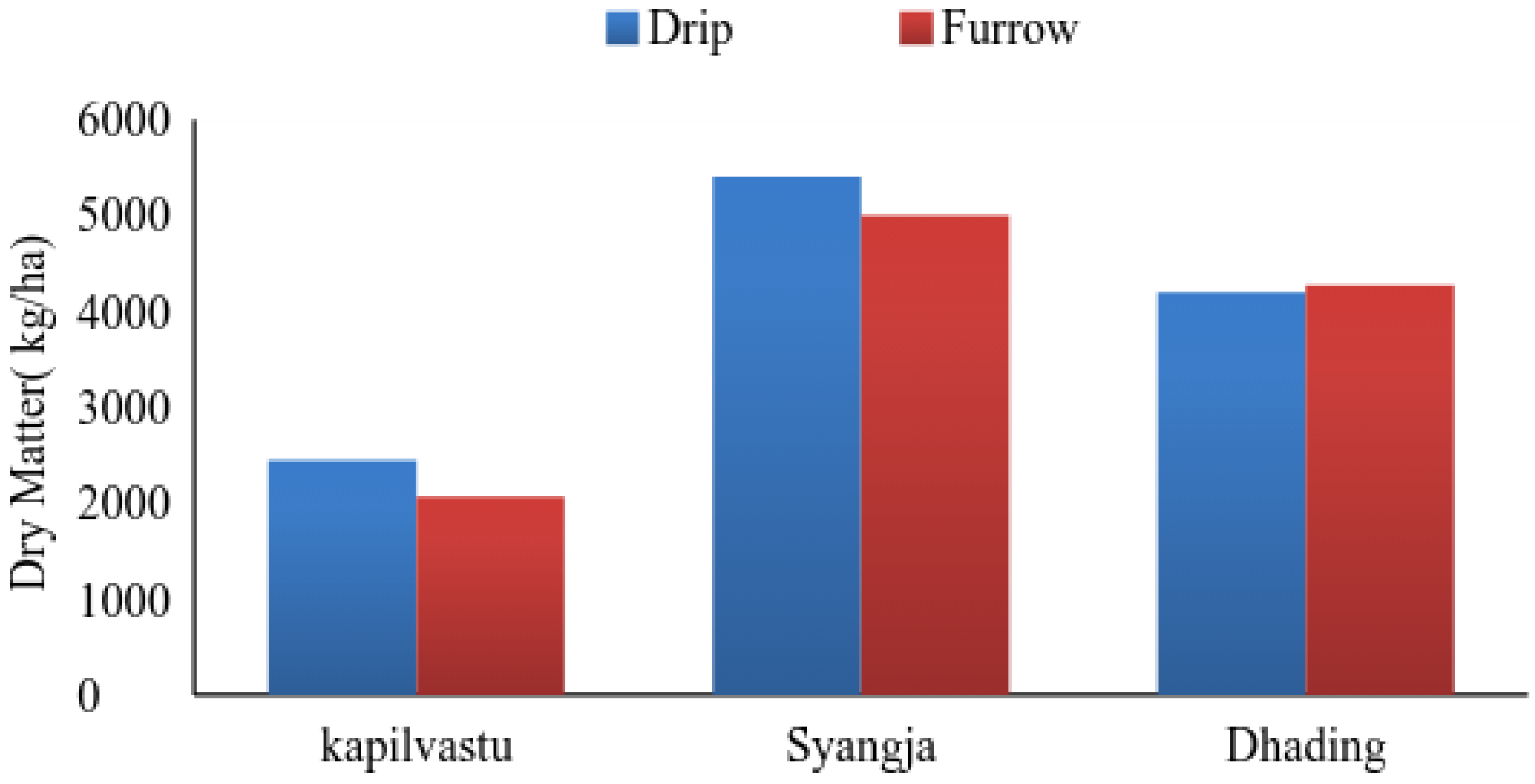
We compared the effect of drip and furrow irrigation on the productivity of common nutritional fodder species using a split-plot design. The factors considered were three sites (Dhading, Syangja, Kapilvastu, representing different elevations and ecological zones in the GRB); two fodder crops (teosinte and cowpea); and two irrigation systems (drip and furrow). Fodder biomass (green and dry weight) was the main measured outcome. Except for the irrigation system, commonly used agronomical practices were followed in all the plots.
To determine biomass (over-ground) green (fresh) weight, green fodder from 1 m2 of each plot was cut and weighed immediately on site. Five hundred gram samples from the fresh biomass were then dried for 24 hours at 70 °C in an oven and weighed to determine dry weight. Two sample cuts of biomass from each plot were averaged.
Figure 2.
Gandaki River Basin, Nepal, showing locations of field sites.
Figure 2.
Gandaki River Basin, Nepal, showing locations of field sites.
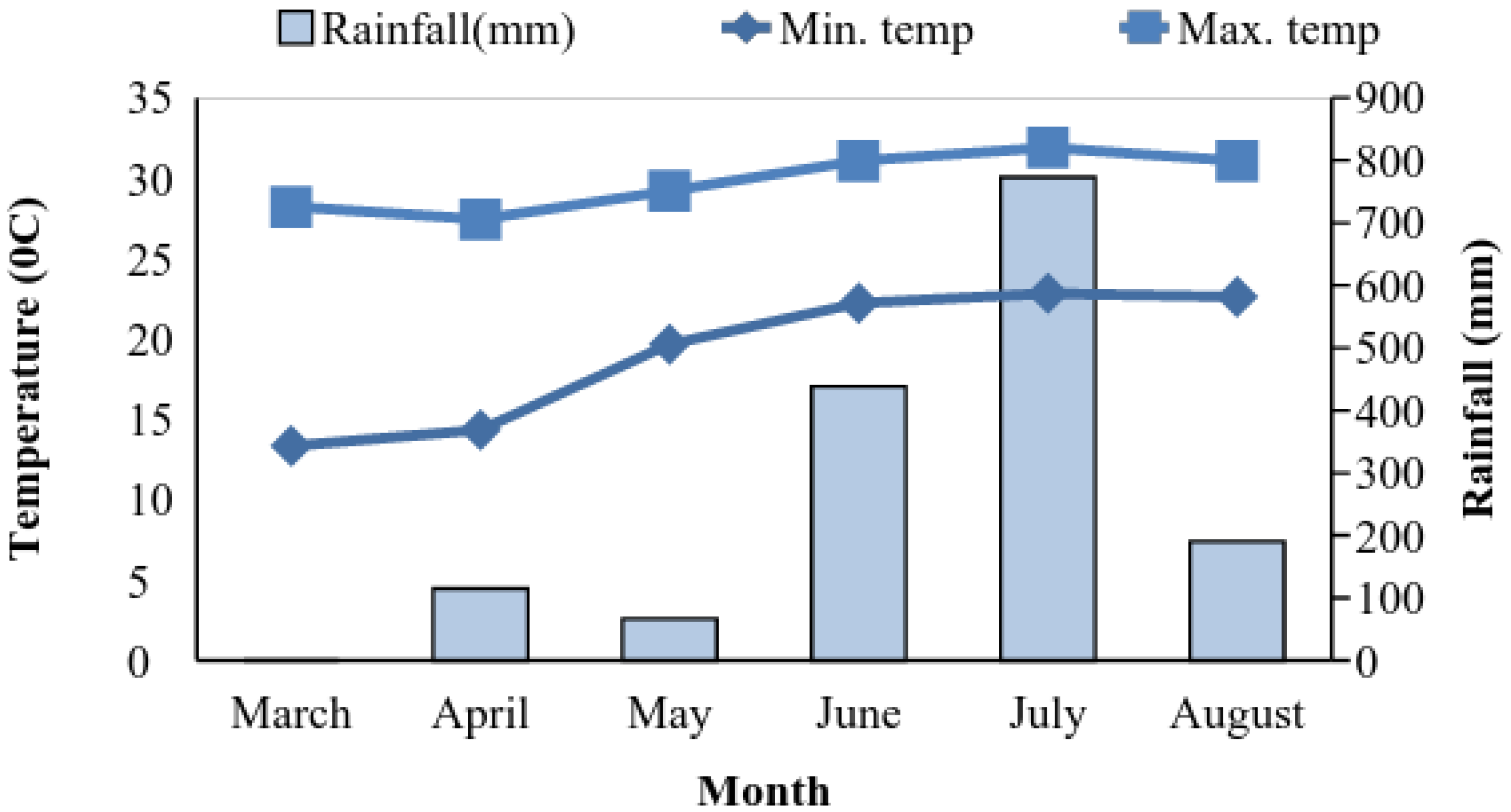
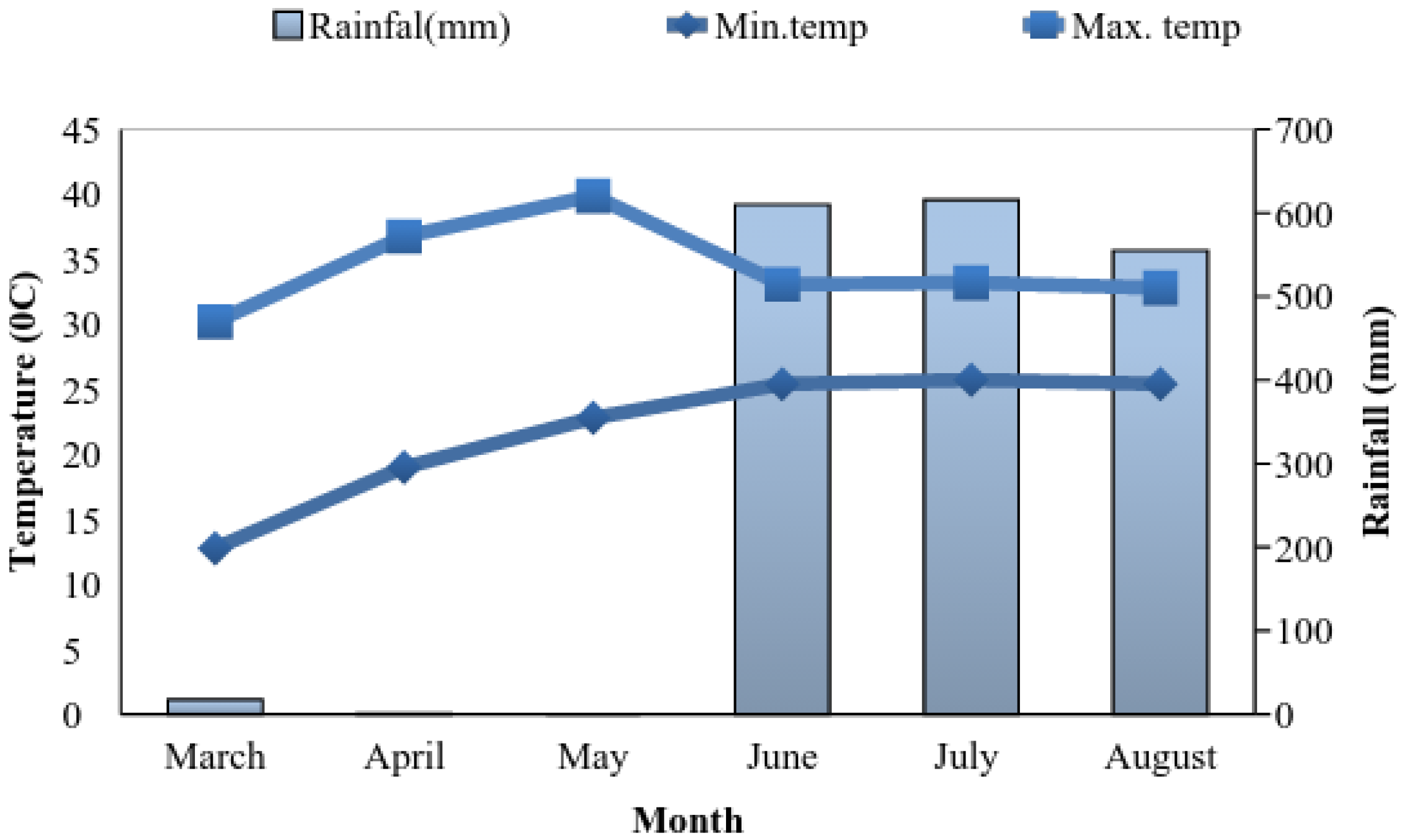
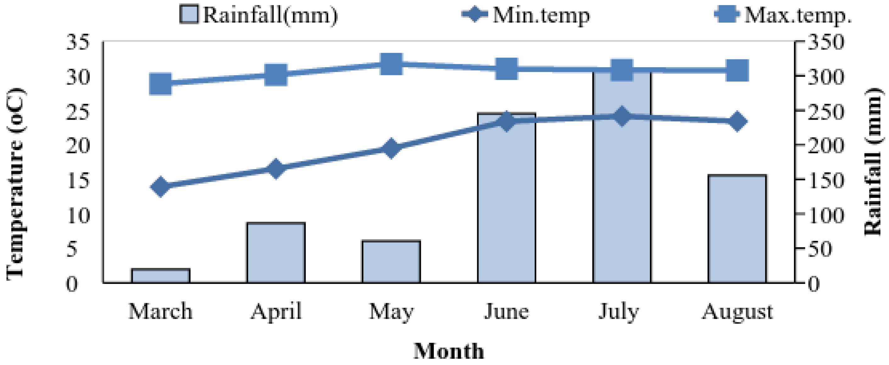
Meteorological conditions: Rainfall and maximum and minimum air temperatures were measured using automatic weather stations installed at each site from 2013 to 2014 (
Figure 3,
Figure 4 and
Figure 5). The period from March–May is hot (especially in the lower-elevation Kapilvastu site) and quite dry, while the summer monsoon normally begins in the early part of June.
Figure 3.
Monthly observed rainfall and mean maximum and minimum temperatures during the 2013–14 growing seasons at the experimental site in Syangja, Nepal.
Figure 3.
Monthly observed rainfall and mean maximum and minimum temperatures during the 2013–14 growing seasons at the experimental site in Syangja, Nepal.
Soil measurements: Five soil samples from 15–20 cm deep were taken using a core sampler from each site before sowing, and combined to make a composite site sample. These samples were air dried in shade for three days and mixed thoroughly, with any debris removed. Soil’s physical and chemical characteristics measured included texture, pH, total organic matter, total nitrogen (N), available phosphorous (P
2O
5), extractable potash (K
2O), field capacity (FC), permanent wilting point (PWP) and bulk density (BD). For analyzing organic matter, soil samples were passed through a 0.5 mm sieve, and 500 g of sample was kept in a plastic bottle for further analysis. The soil properties at the experimental sites and the analysis methods are presented in
Table 1.
Figure 4.
Monthly observed rainfall and mean maximum and minimum temperatures during the 2013–14 growing seasons at the experimental site in Dhading, Nepal.
Figure 4.
Monthly observed rainfall and mean maximum and minimum temperatures during the 2013–14 growing seasons at the experimental site in Dhading, Nepal.
Figure 5.
Monthly observed rainfall and mean maximum and minimum temperatures during the 2013–14 growing seasons at the experimental site in Kapilvastu, Nepal.
Figure 5.
Monthly observed rainfall and mean maximum and minimum temperatures during the 2013–14 growing seasons at the experimental site in Kapilvastu, Nepal.
Table 1.
Soil properties collected from experimental sites.
Table 1.
Soil properties collected from experimental sites.
| Experimental Site | pH | OM (%) | Total N% | P2O5 (kgha−1) | K2O (kgha−1) | Sand (%) | FC (%) | PWP (%) | Silt (%) | Clay (%) | Text | BD (gcm−3) |
|---|
| Kapilvastu | 7.1 | 0.53 | 0.05 | 40.0 | 94.3 | 38.3 | 16 | 29 | 37.5 | 24.1 | L | 1.37 |
| Syangja | 6.9 | 0.77 | 0.06 | 42.5 | 176.5 | 42.5 | 12 | 24.6 | 38.0 | 19.4 | L | 1.41 |
| Dhading | 5.1 | 1.2 | 0.07 | 7.5 | 103.4 | 49.0 | 13.3 | 25 | 29.5 | 21.4 | L | 1.41 |
The experiment was laid out in a split plot design and with six total treatments on each site. Each treatment was replicated four times, resulting in a total of 24 plots. Each individual plot measured 3m in length and 2 m in width. There was 0.5 m spacing between each plot and the main plots were separated by 1 m. There were 6 rows in each plot, with spacing of 0.25 × 0.50 m2. The outermost two rows of both sides of each plot were considered as border rows to study the impact of intercropping cowpea and teosinte compared to growing them separately.
The two nutritious fodder species considered for growing with irrigation during the dry season were cowpea and teosinte. Cowpea (Vigna unguiculata) is a leguminous fodder crop typically grown below 500 m altitude as a pure crop or in mixture with maize, teosinte or napier-bajra hybrid. Cowpea is a crop well adapted to warm weather where there is limited rainfall. The crop is grown in semiarid regions of tropics and sub-tropics. Forage teosinte (Euchlaena mexicana) closely resembles maize and has preferential characteristics like profuse tillering, multi cut, high yield, and nutritional value. It is a tall and vigorously growing crop. It is comparatively less nutritious and palatable than maize, but due to its profuse tilling capacity it gives very good fodder yield. Teosinte can tolerate moderate drought and temporary flooding caused by heavy monsoon showers. Normally, it does not lodge. There is little difference in water requirement between the two crops, with both being well adapted to warm weather and limited rainfall and commonly grown in semiarid regions of the tropics and sub-tropics.
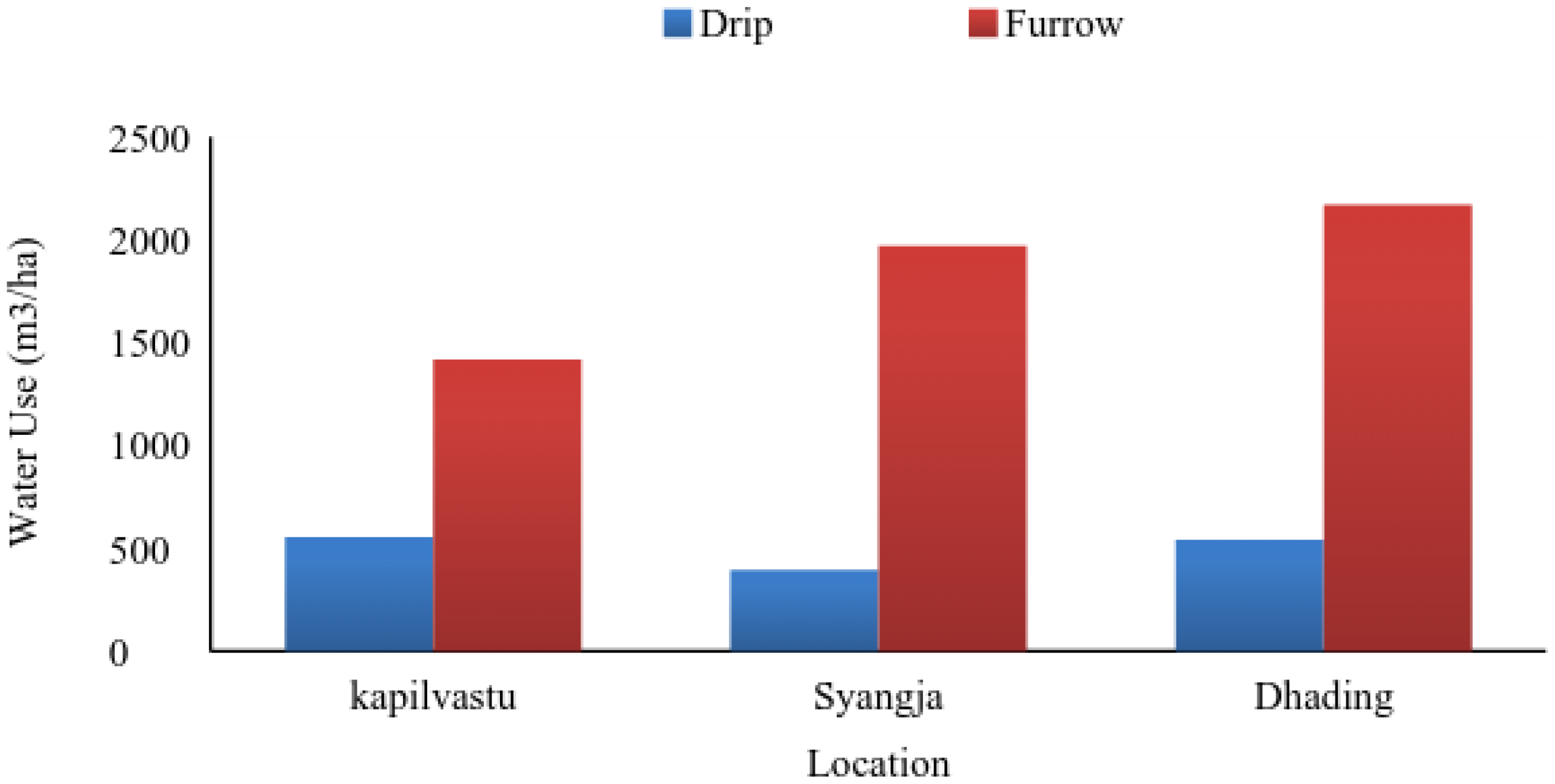
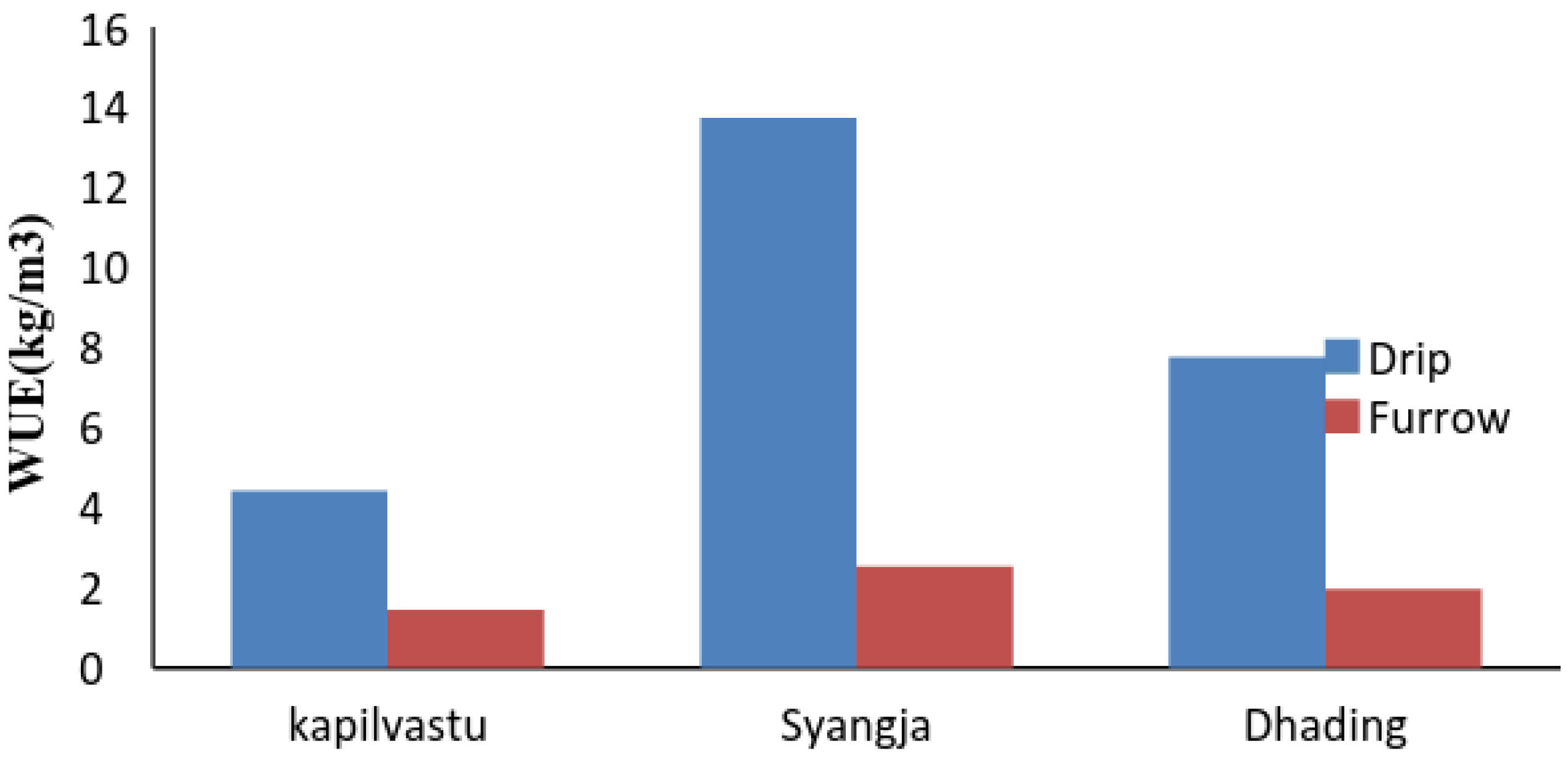
Irrigation schedule: Water was applied at the rate of 80 Liter per day (4 Liter per minute for 20 min) on the drip treatment plots, while, based on prevailing local practice, furrow treatment plots were inundated with 200 Liter per day. The plots were not irrigated on rainy days or on other days when there was sufficient moisture. The irrigation scheduling strategies implemented were intended to prevent over-application of water while minimizing yield loss due to water shortage or drought stress.
Water use efficiency: WUE (kg/m
3) of drip and furrow irrigation systems was calculated by the formula:
where Y = Yield (dry matter) of crop (kg/ha),
Manure and nutrient management: To supply nitrogen (N), phosphorus (P) and potassium (K) at 60:40:40 kg/ha for cowpea and 120:60:40 kg/ha for teosinte, fertilizers were applied at all the sites. Urea, single super phosphate (SSP) and muriate of potash (MOP) were used as sources of fertilizer for supplying these recommended amounts of N, P, and K, respectively.
Statistical analysis: The recorded data were subjected to analysis of variance and Duncan’s Multiple Range Test (DMRT) for mean separations. MSTAT-C Microsoft word computer programs was used for running statistical analysis. ANOVA was used to compare multiple factors and field conditions, and indicate whether the difference between multiple sample means across each factor (location, irrigation method, crop) were significant at the 5% level.


 ,
, 


