3.1. Seasonal and Inter-Annual Fluctuation of Groundwater Levels
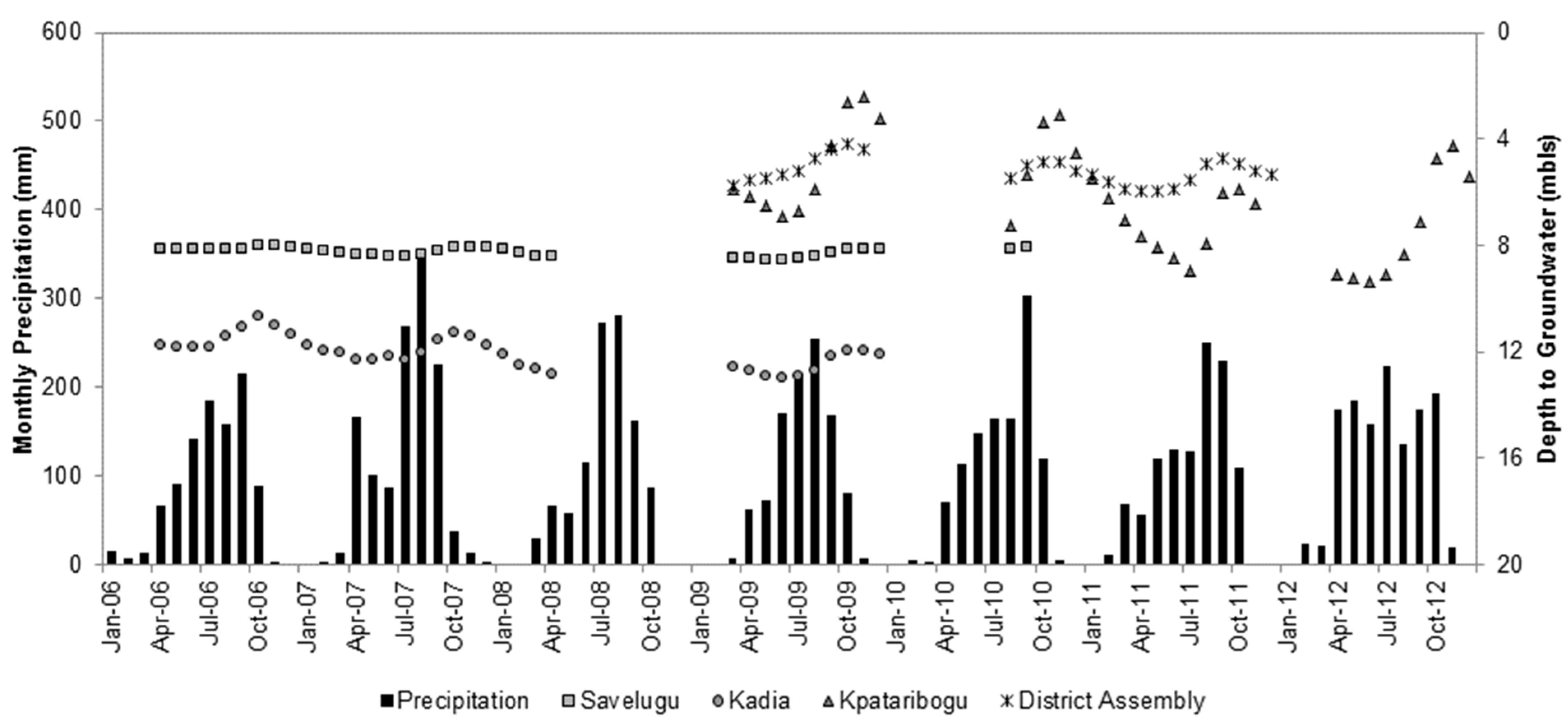
Figure 3 shows average monthly precipitation and average monthly depth to groundwater at each site between January 2006, and December 2012. The depth of groundwater ranges from about 2 mbls at Kpataribogu to 12 mbls at Kadia. Shallow unconfined aquifers, such as those found in the study area, are characterized by groundwater levels less than 50 mbls [
1]. In these types of aquifers, the response of groundwater levels to precipitation can happen during a relatively short period [
12]. At Savelugu, Kadia, Kpataribogu and District Assembly, groundwater levels increase in response to wet-season precipitation, are at their highest levels approximately two to four months following peak wet-season precipitation, then decrease into the dry season. Groundwater levels appear to be deepest below land surface between about April and June.
Figure 3.
Average monthly precipitation (mm) and groundwater level response measured in meters below land surface (mbls) at the study sites.
Figure 3.
Average monthly precipitation (mm) and groundwater level response measured in meters below land surface (mbls) at the study sites.
All groundwater levels show responses to precipitation as increases, though hydrogeologic site uniqueness and spatio-temporal variation of precipitation (both are discussed in more detail later) lead to variation in the amount and timing of response. As compared with the other sites, Savelugu shows relatively small responses of 0.1 to 0.4 m, measured between the lowest point and the peak in the same season. Kadia and District Assembly show slightly larger responses between 1.0 and 1.6 m, respectively. The largest responses are observed at Kpataribogu, with the largest overall of 5.1 m in 2012. Relatively large fluctuations of groundwater are not unusual in aquifers with limited or low porosity [
22]; in similar aquifer systems located in nearby Burkina Faso, groundwater level fluctuations between 1 and 9 m∙yr
−1 are observed [
23]. With respect to timing, increases appear to occur slightly later at Savelugu and Kadia, as compared to Kpataribogu and District Assembly.
The delay between peak precipitation and the response of groundwater suggests that some threshold of precipitation must be reached before the saturation of soil moisture and the rock matrix reaches the aquifer.
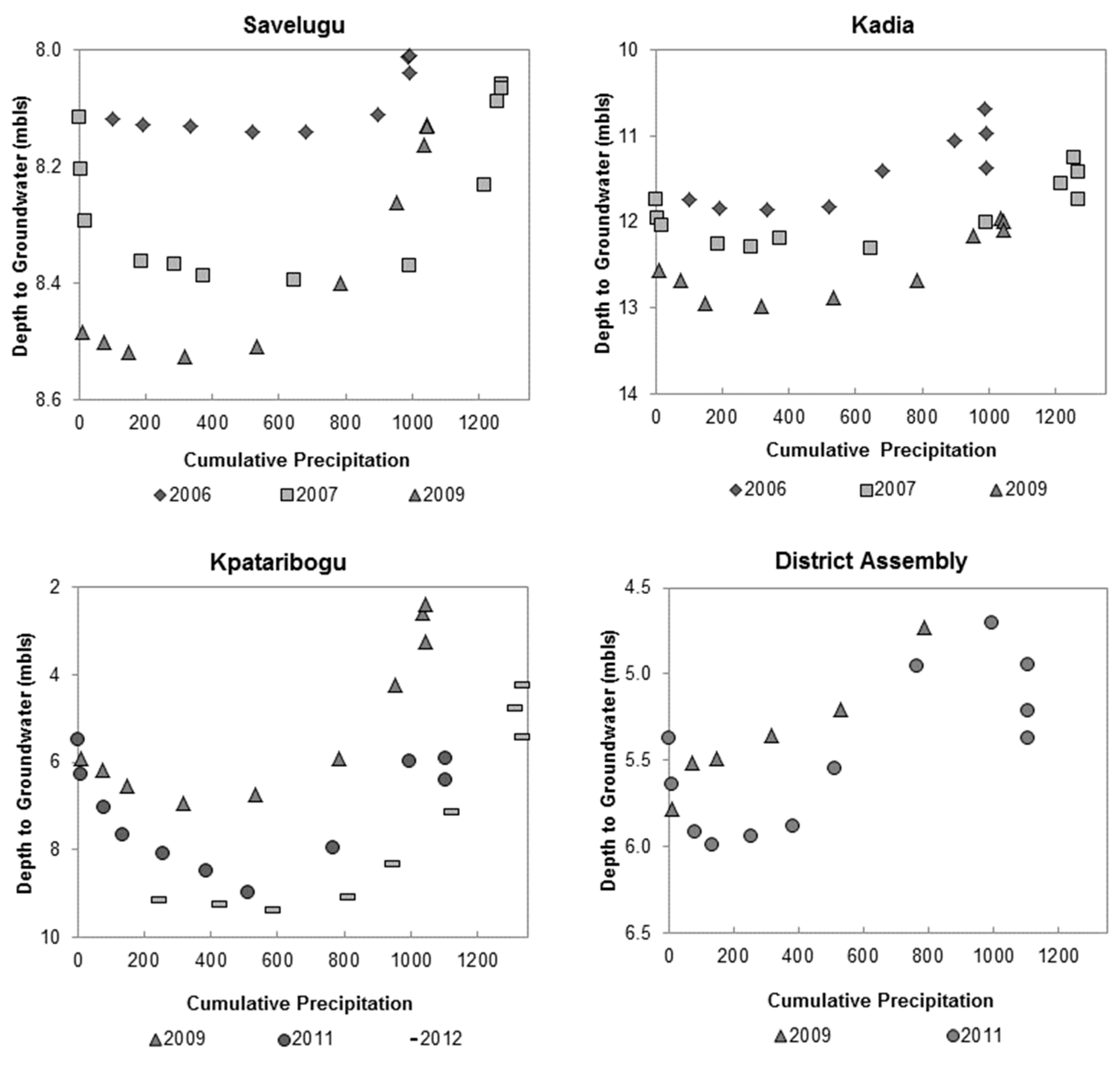
Figure 4 shows monthly groundwater levels in response to cumulative precipitation. Cumulative precipitation is summed for each month beginning in January and added to the sum of the previous month until December is reached. As a generalization across all sites, there is clustering of groundwater level values near zero on the x-axis, when little or no precipitation occurs. Groundwater levels remain relatively constant as precipitation accumulates, then increase more rapidly, almost linearly, after approximately 600 mm occurs. The linear increase breaks down after a maximum threshold of approximately 1000 mm is reached. After that volume, groundwater levels cluster together, remain constant or begin to decline, suggesting the movement of groundwater to other locations in the aquifer.
Variation of thresholds and the measured response of groundwater level on a site-by-site and inter-annual basis may be explained by the spatio-temporal variation of precipitation and hydrogeological site uniqueness. The 600-mm minimum threshold does not apply to District Assembly, for instance, and it does not apply all years at Savelugu and Kadia. Similarly, the maximum threshold of 1000 mm does not apply during 2007 at Savelugu and Kadia nor 2012 at Kpataribogu. Both the minimum and maximum precipitation thresholds are likely to be affected by the variability of precipitation and the saturation of soil moisture and the rock matrix. In similar hard-rock geological systems of India, a threshold of 335 mm∙yr
−1 was observed before recharge took place [
24].
As an example is the larger minimum precipitation threshold at Savelugu and Kadia during 2007. Below-average precipitation during 2006 may have contributed to drier conditions of soil moisture and the rock matrix. During 2007, no significant groundwater level response was observed until 1000 mm of precipitation accumulated. As 1250 mm of accumulated precipitation was exceeded, groundwater level remained steady at 8.1 mbls at Savelugu and 11.5 mbls at Kadia.
Figure 3 shows the onset of above-average April 2007, precipitation, followed by above-average precipitation during August. At this point, the soil and rock matrix were likely to be saturated from April precipitation; any additional precipitation was forming runoff. Some of the worst flooding in decades was reported regionally across West Africa during 2007, with Ghana being particularly hard hit [
25].
Despite the responses of increasing groundwater levels from precipitation each year, however, there is an overall net decline of groundwater levels over the course of the study. Negative departures from average precipitation occurring five of the seven study years (
Table 1) may be linked with these decreases (
Figure 3 and
Figure 4). In the nearby Niger River basin, negative precipitation anomalies are observed with declining groundwater levels [
26]. At Savelugu, the net groundwater level decline is about 0.4 m. The larger decline between 2006 and 2007 may be due to the larger negative precipitation departure during 2006 and is based on the assumption that the 2008 depth to groundwater falls in between those recorded for 2007 and 2009.
Figure 4.
Cumulative monthly precipitation and monthly groundwater level. Cumulative monthly precipitation is summed for each month beginning in January and added to the sum of the previous month until December is reached. The monthly groundwater level is measured as meters below land surface (mbls) at the study sites.
At Kadia, the net decline is 0.9 m, and while the overall decline is greater at Kadia compared to Savelugu, it is difficult to determine if there is annual variation similar to Savelugu. District Assembly shows a decline of about 0.5 m between 2009 and 2011. Kpataribogu shows the largest decline of 3 m, observed between 2009 and 2012. While all sites show a decline of groundwater levels, the decline may be slightly greater at Kpataribogu, due to the mechanized pump extraction in excess of recharge. As more data become available, inter-site and inter-annual comparisons can be made to support or exclude this possibility.
Interestingly, the difference in depth to the groundwater level at Kpataribogu measured between 2011 and 2012 is relatively smaller, suggesting that above-average precipitation during 2012 may be contributing to some recovery of the system. This was not necessarily the case in 2007, when above-average precipitation during two months was associated with flooding. Whereas in 2007, excess precipitation formed runoff, in 2012, precipitation distributed more evenly between April and October may have allowed more substantial recharge to the groundwater system. In semi-arid areas of Africa, precipitation-fed recharge may occur only a few years each decade [
27]. This phenomenon has also been observed in semi-arid areas of India with a similar geology [
24]. As more groundwater level data become available from these study sites, it may be possible to evaluate what precipitation conditions lead to more and less substantial recharge to the aquifer and what type of temporal buffering (storage) the system may offer to offset the effects of drought and mechanized pump extraction.
3.2. Recharge Patterns
In shallow unconfined aquifers where groundwater levels respond to precipitation, the water table fluctuation (WTF) method can be used to calculate recharge. The WTF method is preferred because it is not restricted by the mechanisms by which water flows through the unsaturated zone (preferential pathways); it is best applied to a shallow water table; it can be applied to a fractured rock system; and, it is best in cases of short-term water level rise in response to a series of storms [
23]. This study uses the equation
where Q
prec is the rate of recharge from precipitation in m d
1; S
y is the specific yield of the aquifer; Δϕmod is the modified rise in the groundwater level in m; and Δt is observation period in days [
28]. Measuring precipitation, the response of groundwater levels and recharge over one year, the equation is modified to:
where Q
prec is rewritten as R for recharge in mm∙yr
−1; S
y remains the specific yield of the aquifer; and Δh is the measured increase of groundwater level in mm [
29].
Specific yield, S
y, is a dimensionless storage term that accounts for the release of water by gravity from the aquifer. Values of S
y vary according to geological material, soil, depth of groundwater and fracture size in the case of fractured aquifers [
23]. The increase of groundwater level, Δh, is measured as the difference between the peak in response to precipitation and the low point of the extrapolated antecedent recession curve [
23].
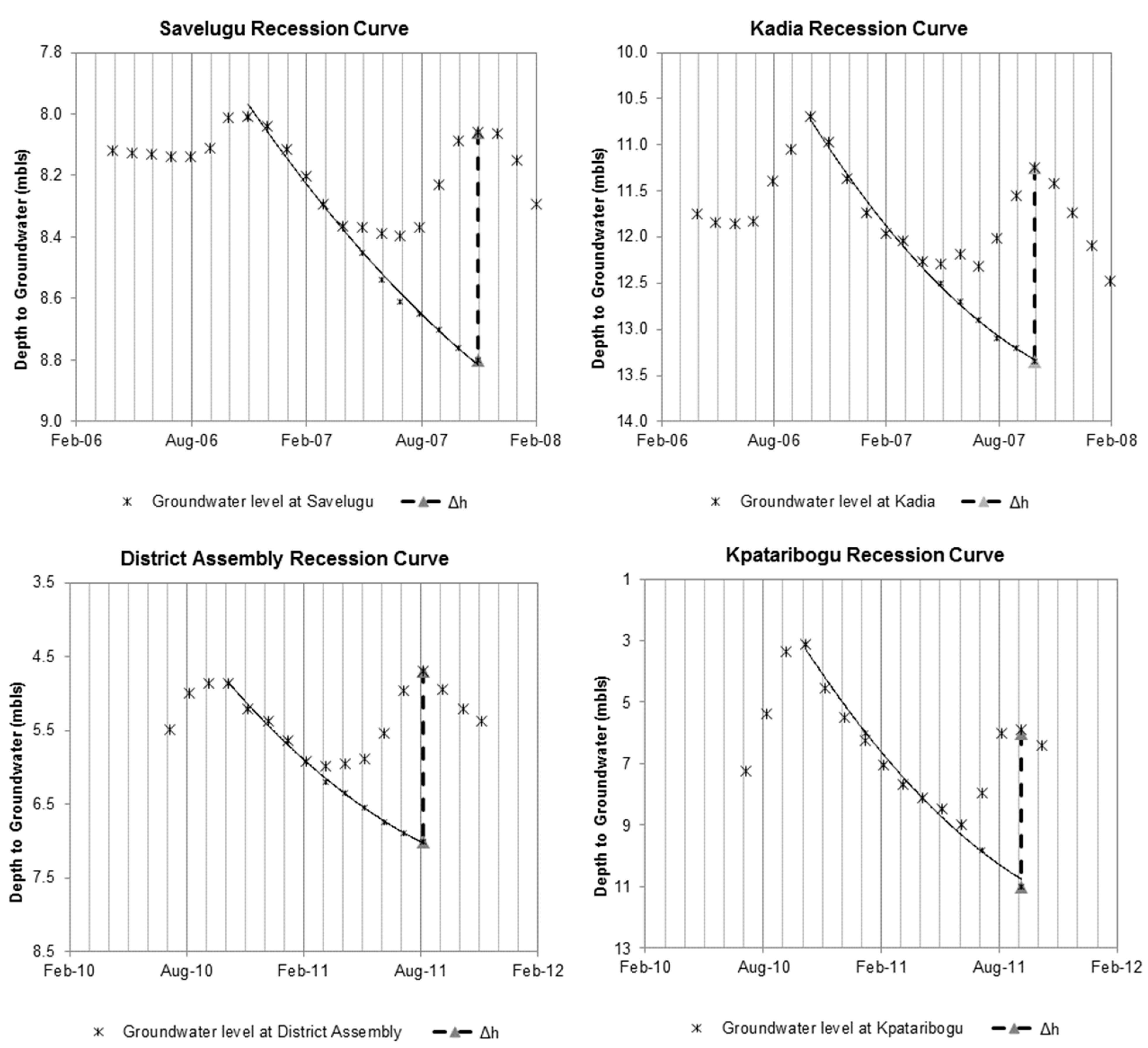
Figure 5 shows extrapolated antecedent recession curves for Savelugu, Kadia, District Assembly and Kpataribogu, giving Δh values of 0.7, 2.1, 5.0 and 2.3 m, respectively.
The variation of Δh between sites and years is attributed in part to hydrogeologic site uniqueness, which includes variation of S
y. There is a near absence of, or very few, reliable estimates of aquifer storage for Africa [
2]. A review of S
y from the literature gives values ranging from 0.02 to 2.1 for fractured sandstones in similar fractured sandstone aquifer systems in Mali [
30] and Utah [
31]. Applying the full range of S
y values, however, gives estimates of recharge that far exceed the total amount of annual precipitation. The maximum observed recharge for fractured sandstone is 20% of average annual precipitation or 225 mm [
31]. Using that value as an upper-limit constricts values of S
y from: 0.02 to 0.3 at Savelugu, 0.02 to 0.11 at Kadia, 0.02 to 0.05 at Kpataribogu and 0.02 to 0.10 at District Assembly.
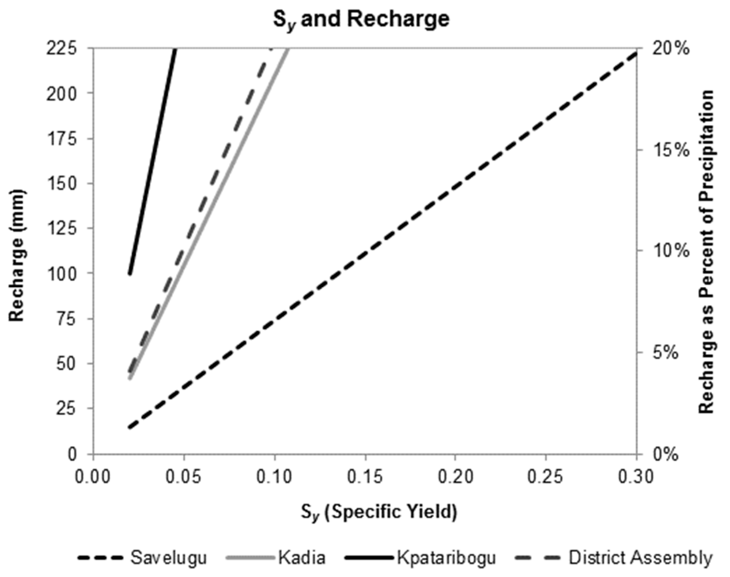
Figure 6 shows the range of recharge estimates based on these S
y values.
Besides hydrogeologic site uniqueness, the differences of Δh are also attributed to spatio-temporal variation of precipitation. A study of spatio-temporal precipitation patterns in a 9 by 9-km grid near Tamale yielded coefficient of variation values from 0.25 to 0.4 and concluded that reliable point precipitation is “extremely difficult to determine” [
21]. Supporting this is a slight increase in groundwater levels during June, 2007, at Kadia in response to above-average April precipitation; there is a slight response during May at Savelugu (
Figure 3). It is plausible that more April precipitation occurred at Kadia compared to Savelugu.
Figure 5.
Extrapolated antecedent recession curves to determine Δh for recharge calculations at the study sites.
Figure 5.
Extrapolated antecedent recession curves to determine Δh for recharge calculations at the study sites.
On a site-by-site basis, a vast matrix of information is generated by the observation of groundwater levels, precipitation data, consideration of S
y values and resultant recharge patterns. When the sites are viewed as a continuum, however, more reasonable recharge estimates emerge. Savelugu may be a reasonable representation of the study area continuum. At Kadia, Kpataribogu and District Assembly, hydrogeological conditions are such that the response to precipitation is greater and more rapid, as observed by larger increases of the groundwater levels’ shorter lag times, respectively. Until more sites can be included in this study, it cannot be assumed that conditions at these three sites are representative of the area. Studies made in other areas of northern Ghana and parts of Burkina Faso give estimates that approximately 3.7% to 5% of average annual precipitation recharges groundwater by infiltration through the soil and rock matrix [
7,
9,
19].
Figure 5 shows that, with the exception of Savelugu, these estimates are low, given the groundwater level responses observed and S
y values used in this study. At Kadia, Kpataribogu and District Assembly, more than 3.7% to 5% of average annual precipitation forms recharge.
Figure 6.
Range of recharge estimates for study sites using values of Sy (specific yield).
Figure 6.
Range of recharge estimates for study sites using values of Sy (specific yield).
Additionally, Savelugu may be a reasonable representation of the study area continuum, because it is a hand pump and experiences the least amount of pumping. Both District Assembly and Kadia are sites that the authors have observed as being frequently pumped. It is currently unclear if Kpataribogu, a mechanized pump, is experiencing extraction in excess of recharge. Conditions at Savelugu are more likely to represent recharge patterns and more conservative estimates of recharge of the study area continuum.
3.3. Caveats and Potential Benefits
Several caveats and potential benefits are noted for this study. One caveat is the limitation of the dataset (groundwater levels are sporadically available from a few sites, causing difficulty for making inter-site and inter-annual comparisons with groundwater levels in this study). Furthermore, the gridded precipitation data cannot account for spatio-temporal variability; however, even a 9 by 9 km precipitation network could not. The implementation of precipitation gauges at each individual study site is ideal. Finally, while the gross surficial geology of the study area is understood, more localized sub-surface geologic investigations are lacking. The same is true with respect to localized hydrogeologic parameters.
The overarching potential benefit of any study is to contribute to closing knowledge gaps. In this study, evaluating seasonal fluctuations of groundwater levels, for instance, helps the sustainability of the wells in the area. Drillers can now ensure that wells and pumps are at depths sufficient enough, so as to avoid hand pump failure due to declining groundwater levels during the dry season. Evaluating inter-annual fluctuations of groundwater levels helps to determine groundwater storage and the quantity available. For instance, the study sites may reveal the system’s capacity (or lack thereof) to provide the resource despite groundwater level declines due to several years of negative departures of precipitation. Conversely, the sites may show what precipitation conditions lead to the recovery of the system, following the notion that precipitation-fed recharge may occur only a few years each decade. A more thorough evaluation of recharge patterns with respect to the onset/distribution of precipitation and the frequency of extreme events will become increasingly critical, since the changes of precipitation patterns are future climate projections for many tropical and semi-tropical areas [
1,
32].
In the interest of closing knowledge gaps, the sites in this study are actively used community wells and may provide information as to extraction patterns. Currently, extraction volumes from hand pumps are not known, and many studies use manufacturer’s specifications of hand pump yield. With borehole log information, it may be possible to evaluate true hand pump yield and understand community usage patterns. The added benefit of including Kpataribogu in the study will provide insight into the potential effects on the groundwater system as more communities move towards mechanized groundwater pumping systems with storage tanks and distribution pipes in the community. Though water quality is beyond the scope of this study, the hand pump at Kadia is connected to a treatment system for the removal of naturally-occurring arsenic. Another interesting study could assess whether seasonal and inter-annual variations in arsenic concentrations are correlated with recharge patterns.


