Areal Delineation of Home Regions from Contribution and Editing Patterns in OpenStreetMap



Abstract
1. Introduction
2. Contribution Patterns in OSM
3. Areal Delineation of OSM Contributor Information
3.1. Data Preparation and Contributor Selection

| OSM Member | Created Nodes | Modified Nodes | No. of Changesets | No. of Countries | Active Days (abs.) | Active Days (%) |
|---|---|---|---|---|---|---|
| 1 | 325,139 | 145,951 | 2369 | 12 | 1456 | 57% |
| 2 | 429,962 | 146,510 | 3811 | 15 | 1084 | 82% |
| 3 | 917,417 | 164,612 | 4486 | 13 | 833 | 77% |
| 4 | 402,783 | 119,269 | 6915 | 8 | 1280 | 87% |
| 5 | 333,075 | 101,109 | 7470 | 3 | 896 | 56% |
| 6 | 779,798 | 338,749 | 14,810 | 11 | 1586 | 86% |
| 7 | 573,133 | 79,008 | 4577 | 4 | 722 | 87% |
| 8 | 920,702 | 112,489 | 20,398 | 14 | 1827 | 84% |
| 9 | 774,395 | 299,257 | 16,340 | 7 | 1402 | 87% |
| 10 | 475,366 | 2,090,481 | 21,188 | 4 | 1979 | 88% |
| 11 | 949,472 | 330,927 | 5946 | 4 | 1298 | 81% |
| 12 | 471,268 | 60,759 | 1137 | 3 | 727 | 84% |
| 13 | 340,912 | 200,771 | 2260 | 11 | 625 | 85% |
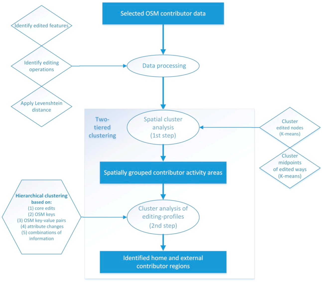
| Operations | Node | Way | |
|---|---|---|---|
| Core edits | Remove/add/update tag | x | x |
| Remove/add/update primary tag | x | x | |
| Add geometry (new feature) | x | x | |
| Change geometry position | x | ||
| Remove node from way | x | ||
| Add node to way | x | ||
| Attribute changes | Name | x | x |
| Address | x | x | |
| Traffic signs | x | ||
| Crossing | x | ||
| Cycleway | x | ||
| Surface | x | ||
| Foot | x | ||
| Oneway | x | ||
| Restrictions motorized | x | ||
| General restrictions | x |
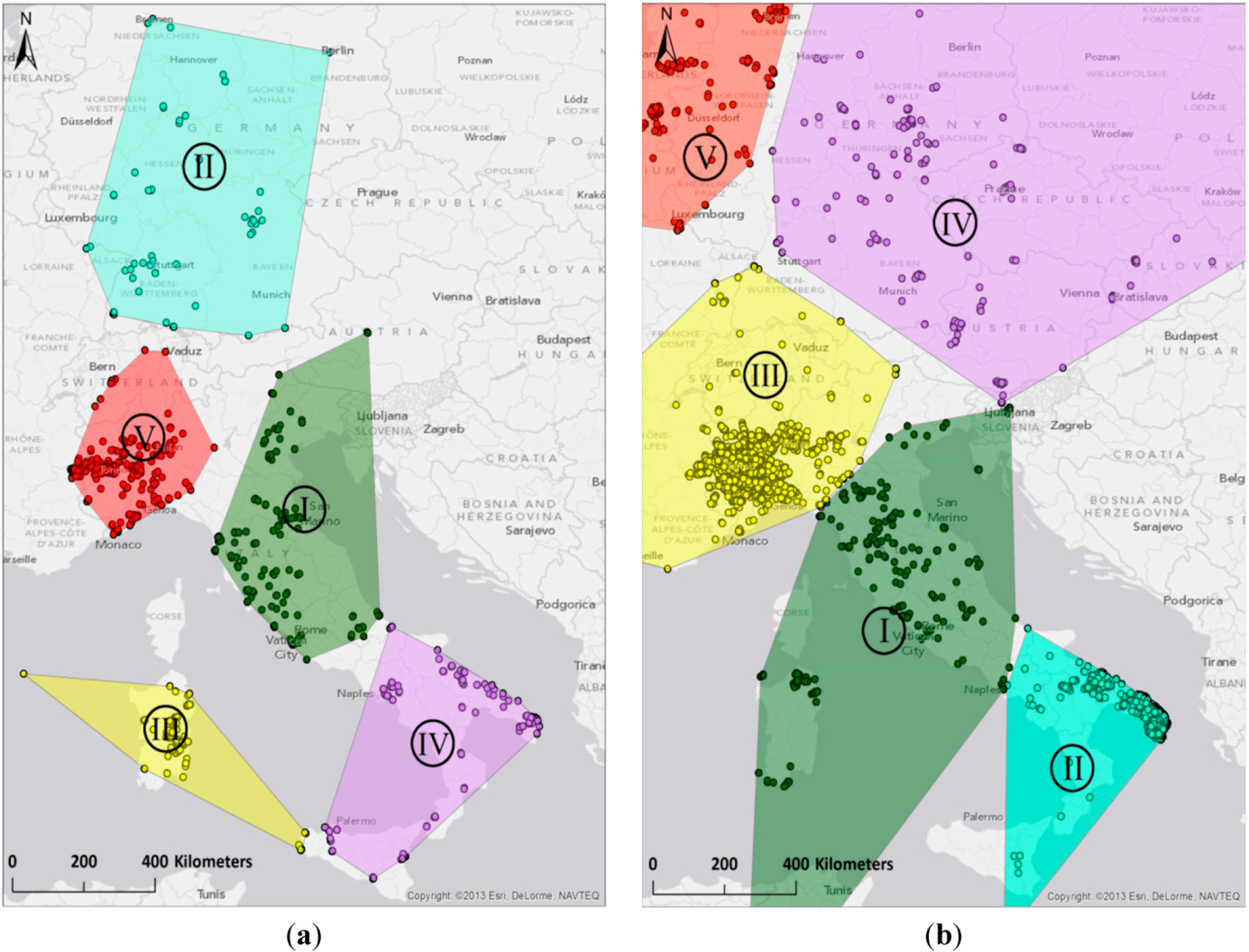
3.2. Clustering Step 1: Spatial Delineation of Activity Areas through k-Means Clustering
| K_grp | K_grp Size | Rem Tag | Add Tag | Upd Tag | … | Key Sum1 | Key Sum2 | … | KeyVal Sum1 | KeyVal Sum2 | … |
|---|---|---|---|---|---|---|---|---|---|---|---|
| 1 | 245 | 0.000 | 0.012 | 0.000 | … | 0.000 | 0.992 | … | 0.000 | 0.976 | … |
| 2 | 97 | 0.000 | 0.010 | 0.010 | … | 0.000 | 0.763 | … | 0.000 | 0.763 | … |
| 3 | 91 | 0.000 | 0.000 | 0.000 | … | 0.000 | 0.989 | … | 0.000 | 0.989 | … |
| 4 | 231 | 0.000 | 0.013 | 0.000 | … | 0.000 | 0.961 | … | 0.000 | 0.887 | … |
| 5 | 1662 | 0.016 | 0.223 | 0.076 | … | 0.002 | 0.764 | … | 0.001 | 0.487 | … |
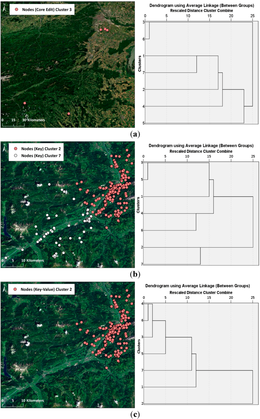
3.3. Clustering Step 2: Identification of Home and External Region through Hierarchical Clustering of Region-Based Editing Profiles
| OSM Member | Core Edits | Keys | Key-Values | |||
|---|---|---|---|---|---|---|
| Nodes | Ways | Nodes | Ways | Nodes | Ways | |
| 1 | - | - | 2 | 1 | 1 | 1 |
| 2 | 1 | - | 1 | 1 | 1 | 1 |
| 3 | 1 | - | 1 | 2 | 1 | 2 |
| 4 | - | - | - | - | 1 | 1 |
| 5 | - | - | - | 1 | 1 | 1 |
| 6 | 1 | - | 1 | 1 | 1 | 1 |
| 7 | - | - | 1 | 1 | 1 | 1 |
| 8 | - | - | - | - | 1 | 1 |
| 9 | - | 1 | 1 | - | 1 | 1 |
| 10 | 1 | - | - | - | 1 | 1 |
| 11 | - | - | 1 | - | - | - |
| 12 | - | - | - | - | 1 | 1 |
| 13 | - | - | - | 1 | 1 | 1 |
| TOTAL SUCCESS | 4 | 1 | 7 | 7 | 12 | 11 |
4. Evaluation
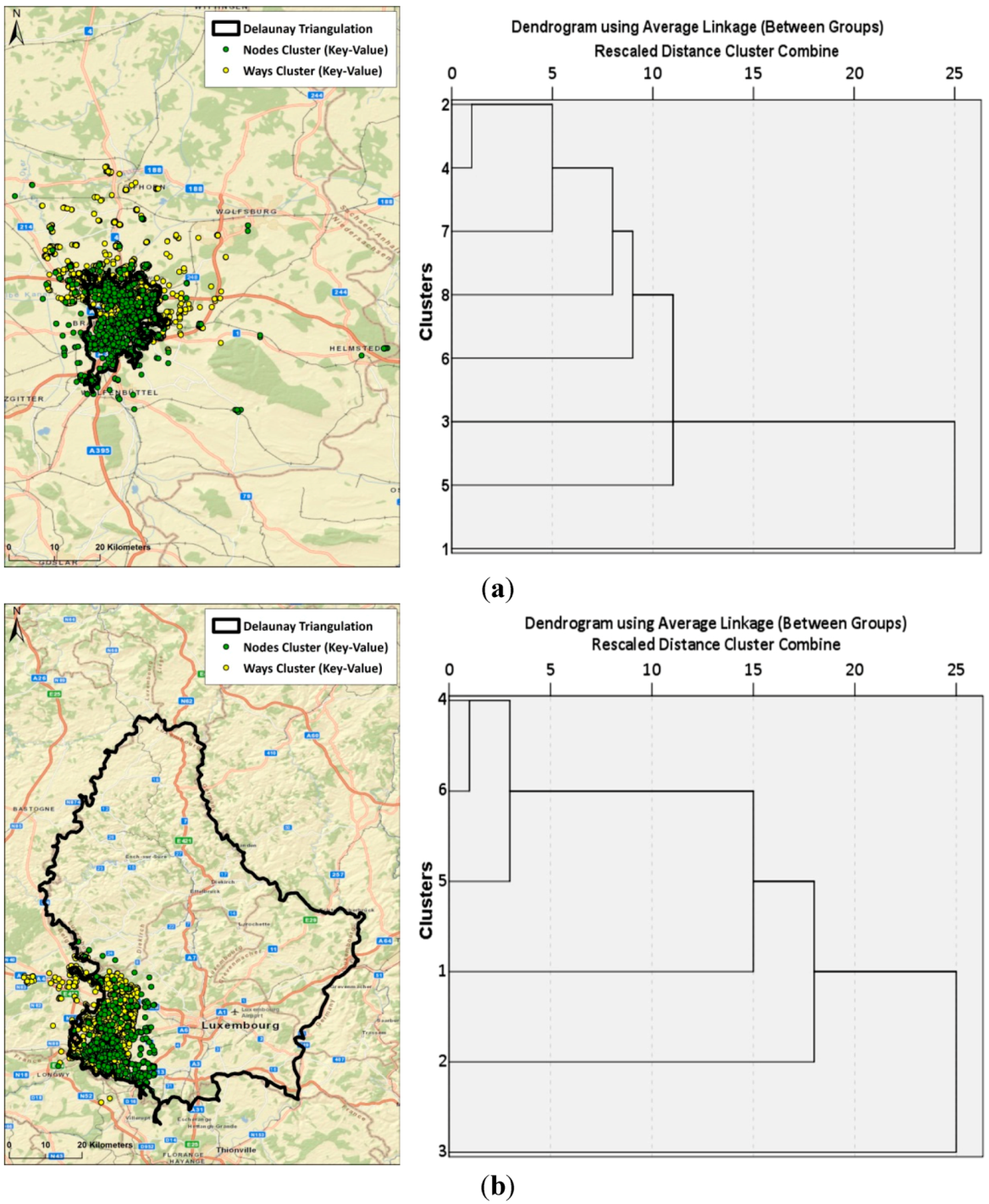
4.1. Comparison of Cluster Methods
4.2. Classification Sensitivity
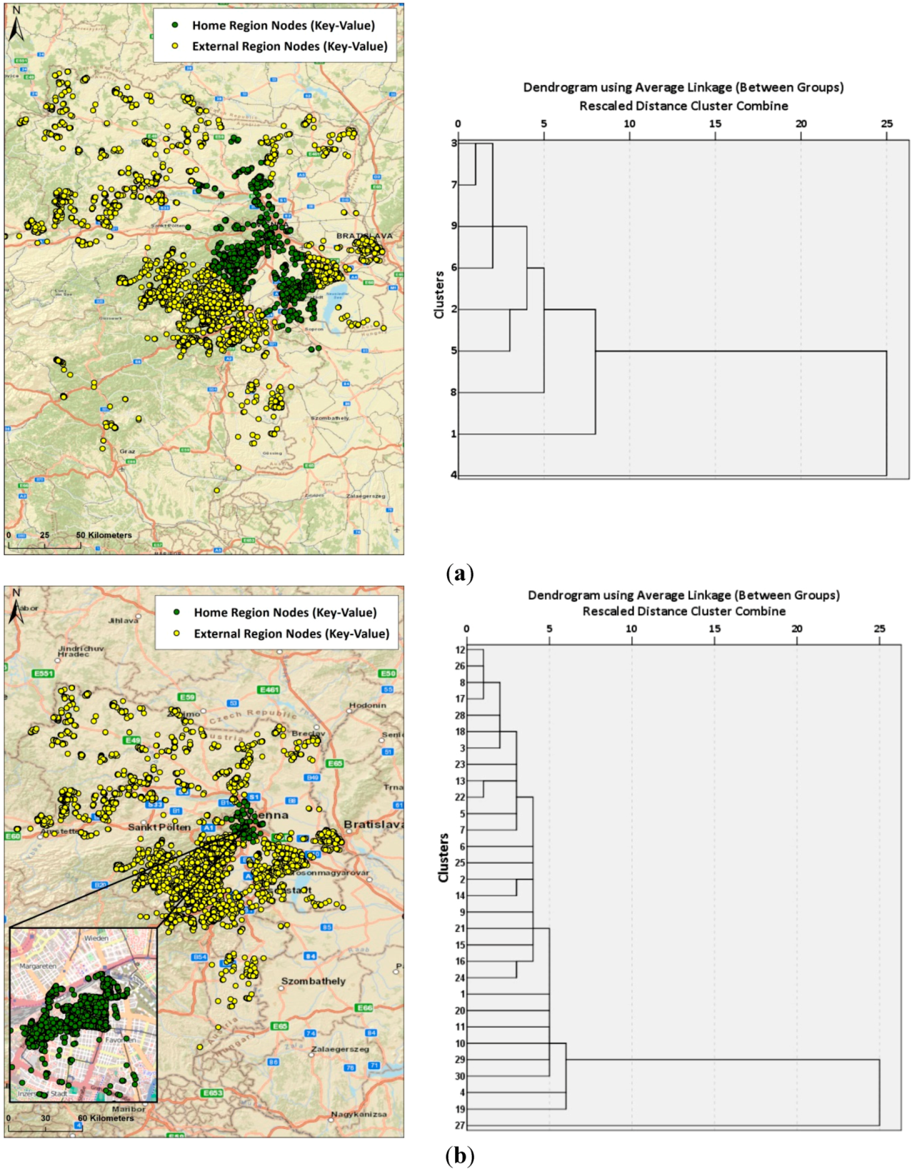
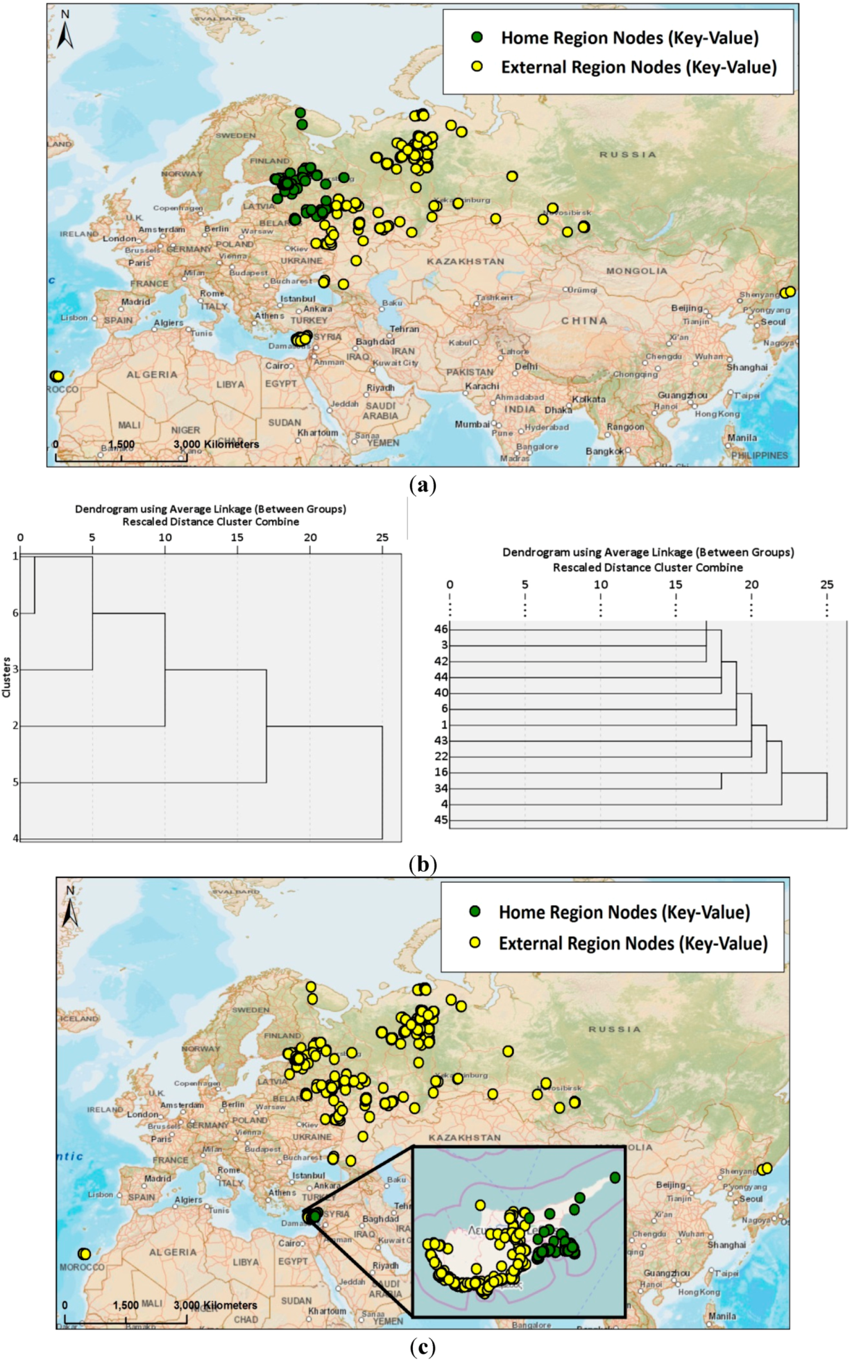
4.3. Diversity and Activity
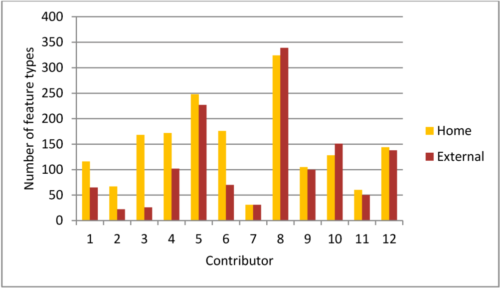
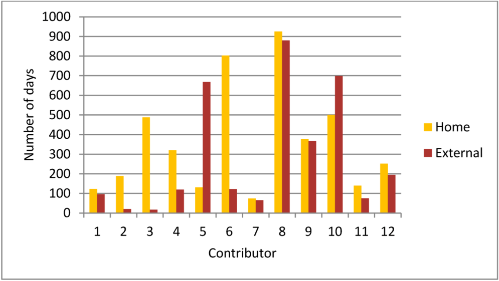
5. Summary and Conclusions
Author Contributions
Conflicts of Interest
References
- Goodchild, M.F. Citizens as voluntary sensors: Spatial data infrastructure in the World of Web 2.0. Int. J. Spat. Data Infrastruct. Res. (IJSDIR) 2007, 2, 24–32. [Google Scholar]
- Girardin, F.; Blat, J.; Calabrese, F.; Fiore, F.D.; Ratti, C. Digital footprinting: Uncovering tourists with user-generated content. Pervasive Comput. 2008, 7, 36–43. [Google Scholar] [CrossRef]
- Andrienko, G.; Andrienko, N.; Bak, P.; Kisilevich, S.; Keim, D. Analysis of community-contributed space- and time-referenced data (example of flickr and panoramio photos). In Proceedings of the IEEE Symposium on Visual Analytics Science and Technology, Atlantic City, NJ, USA, 12–13 October 2009; pp. 213–214.
- Chen, L.; Roy, A. Event detection from flickr data through wavelet-based spatial analysis. In Proceedings of the 18th ACM Conference on Information and Knowledge Management, Hong Kong, China, 2–6 November 2009; ACM: New York, NY, USA; pp. 523–532.
- Schlieder, C.; Matyas, C. Photographing a city: An analysis of place concepts based on spatial choices. Spat. Cogn. Comput. 2009, 9, 212–228. [Google Scholar]
- Hollenstein, L.; Purves, R.S. Exploring place through user-generated content: Using flickr to describe city cores. J. Spat. Inf. Sci. 2010, 1, 21–48. [Google Scholar]
- Andrienko, G.; Andrienko, N.; Bosch, H.; Ertl, T.; Fuchs, G.; Jankowski, P.; Thom, D. Thematics patterns in georeferenced tweets through space-time visual analytics. Comput. Sci. Eng. 2013, 15, 72–82. [Google Scholar] [CrossRef]
- Krumm, J.; Caruana, R.; Counts, S. Learning likely locations. In User Modeling, Adaption, and Personalization; Carberry, S., Weibelzahl, S., Micarelli, A., Semeraro, G., Eds.; Springer: Berlin, Germany; pp. 64–76.
- Li, Y.; Shan, J. Understanding the spatio-temporal pattern of tweets. Photogramm. Eng. Remote Sens. 2013, 79, 769–773. [Google Scholar] [CrossRef]
- Collins, C.; Hasan, S.; Ukkusuri, S.V. A novel transit rider satisfaction metric: Rider sentiments measured from online social media data. J. Public Transp. 2013, 16, 21–45. [Google Scholar]
- Mitchell, L.; Frank, M.R.; Harris, K.D.; Dodds, P.S.; Danforth, C.M. The geography of happiness: Connecting twitter sentiment and expression, demographics, and objective characteristics of place. PLoS One 2013, 8, e64417. [Google Scholar] [CrossRef] [PubMed]
- Noulas, A.; Scellato, S.; Mascolo, C.; Pontil, M. An empirical study of geographic user activity patterns in foursquare. In Proceedings of the 5th International AAAI Conference on Weblogs and Social Media, Menlo Park, CA, USA, 19–21 July 2011; Adamic, L., Baeza-Yates, R., Counts, S., Eds.; The AAAI Press: Palo Alto, CA, USA; pp. 570–573.
- Mooney, P.; Corcoran, P. Characteristics of heavily edited objects in OpenStreetMap. Future Internet 2012, 4, 285–305. [Google Scholar] [CrossRef]
- Arsanjani, J.J.; Barron, C.; Bakillah, M.; Helbich, M. Assessing the quality of OpenStreetMap contributors together with their contributions. In Proceedings of the AGILE 2013, Leuven, Belgium, 5–9 August 2013.
- Haklay, M.; Basiouka, S.; Antoniou, V.; Ather, A. How many volunteers does it take to map an area well? The validity of Linus’ law to volunteered geographic information. Cartogr. J. 2010, 47, 315–322. [Google Scholar] [CrossRef]
- Neis, P.; Zielstra, D.; Zipf, A. Comparison of volunteered geographic information data contributions and community development for selected world regions. Future Internet 2013, 5, 282–300. [Google Scholar] [CrossRef]
- Neis, P.; Zipf, A. Analyzing the contributor activity of a volunteered geographic information Project—The case of OpenStreetMap. ISPRS Int. J. Geo. Inf. 2012, 1, 146–165. [Google Scholar] [CrossRef]
- Heipke, C. Crowdsourcing geospatial data. ISPRS J. Photogramm. Remote Sens. 2010, 65, 550–557. [Google Scholar] [CrossRef]
- Mooney, P.; Corcoran, P. Analysis of interaction and co-editing patterns amongst OpenStreetMap contributors. Trans. GIS 2013, 18, 633–659. [Google Scholar] [CrossRef]
- Gröchenig, S.; Brunauer, R.; Rehrl, K. Estimating completeness of VGI datasets by analyzing community activity over time periods. In Connecting a Digital Europe through Location and Place; Huerta, J., Schade, S., Granell, C., Eds.; Springer: Berlin, Germany, 2014; pp. 3–18. [Google Scholar]
- Rehrl, K.; Gröchenig, S.; Hochmair, H.H.; Leitinger, S.; Steinmann, R.; Wagner, A. A conceptual model for analyzing contribution patterns in the context of VGI. In Progress in Location Based Services; Krisp, J.M., Ed.; Springer: Berlin, Germany, 2013; pp. 373–388. [Google Scholar]
- Gröchenig, S. Using Spatial and Temporal Editing Patterns for Evaluation of Open Street Map Data. MSc Thesis, Carinthia University of Applied Sciences, Villach, Carinthia, Austria, 2012. [Google Scholar]
- Steinmann, R.; Brunauer, R.; Gröchenig, S.; Rehrl, K. Wie aktiv sind freiwillige Mapper? Ein Vergleich der OpenStreetMap-Aktivitäten in den Jahren 2005–2012 am Beispiel der DACH-Region. In Angewandte Geoinformatik; Strobl, J., Blaschke, T., Griesebner, G., Zagel, B., Eds.; Wichmann: Berlin, Germany, 2013; pp. 173–182. [Google Scholar]
- Steinmann, R.; Gröchenig, S.; Rehrl, K.; Brunauer, R. Contribution profiles of voluntary mappers in OpenStreetMap. In Proceedings of Action and Interaction in Volunteered Geographic Information (ACTIVITY) Workshop at AGILE 2013, Leuven, Belgium, 14 May 2013.
- Haklay, M. How good is Volunteered Geographical Information? A comparative study of OpenStreetMap and Ordnance Survey datasets. Environ. Plan. B Plan. Des. 2010, 37, 682–703. [Google Scholar]
- Zielstra, D.; Zipf, A. OpenStreetMap data quality research in Germany. In Proceedings of the 6th International Conference on Geographic Information Science (GIScience), Zurich, Switzerland, 14–17 September 2010.
- Neis, P.; Zielstra, D.; Zipf, A. The street network evolution of crowdsourced maps: OpenStreetMap in Germany 2007–2011. Future Internet 2012, 4, 1–21. [Google Scholar]
- Zielstra, D.; Hochmair, H.H. Using free and proprietary data to compare shortest-path lengths for effective pedestrian routing in street networks. Transp. Res. Record 2012, 2299, 41–47. [Google Scholar] [CrossRef]
- Zielstra, D.; Hochmair, H.H. A comparative study of pedestrian accessibility to transit stations using free and proprietary network data. Transp. Res. Record 2011, 2217, 145–152. [Google Scholar] [CrossRef]
- Hochmair, H.H.; Zielstra, D.; Neis, P. Assessing the completeness of bicycle trail and designated lane features in OpenStreetMap for the United States. Trans. GIS 2014, in press. [Google Scholar]
- Zook, M.A.; Graham, M.; Shelton, T.; Gorman, S. Volunteered geographic information and crowdsourcing disaster relief: A case study of the Haitian earthquake. World Med. Health Policy 2010, 2, 7–33. [Google Scholar] [CrossRef]
- Parker, C.J.; May, A.J.; Mitchell, V. The role of VGI and PGI in supporting outdoor activities. Appl. Ergon. 2012, 44, 886–894. [Google Scholar] [CrossRef] [PubMed]
- Parker, C.J.; May, A.J.; Mitchell, V. User centred design of neogeography: The impact of volunteered geographic information on trust of online map “mashups”. Ergonomics 2014, 57, 987–997. [Google Scholar] [CrossRef] [PubMed]
- Parker, C.J.; May, A.J.; Mitchell, V. Understanding design with VGI using an information relevance framework. Trans. GIS 2012, 16, 545–560. [Google Scholar] [CrossRef]
- Girres, J.F.; Touya, G. Quality assessment of the French OpenStreetMap dataset. Trans. GIS 2010, 14, 435–459. [Google Scholar] [CrossRef]
- Mooney, P.; Corcoran, P. The annotation process in OpenStreetMap. Trans. GIS 2012, 16, 561–579. [Google Scholar] [CrossRef]
- Keßler, C.; de Groot, R. Trust as a Proxy Measure for the quality of volunteered geographic information in the case of OpenStreetMap. In Geographic Information Science at the Heart of Europe; Vandenbroucke, D., Bucher, B., Crompvoets, J., Eds.; Springer: Heidelberg, Germany, 2013; pp. 21–37. [Google Scholar]
- Keßler, C.; Trame, J.; Kauppinen, T. Provenance and trust in volunteered geographic information: The case of OpenStreetMap. In Proceedings of the Conference on Spatial Information Theory: COSIT’11, Belfast, ME, USA, 12–16 September 2011; pp. 1–3.
- Zielstra, D.; Hochmair, H.H.; Neis, P. Assessing the effect of data imports on the completeness of OpenStreetMap—A United States case study. Trans. GIS 2013, 17, 315–334. [Google Scholar] [CrossRef]
- Hochmair, H.H.; Zielstra, D. Development and completeness of points of interest in free and proprietary data sets: A Florida case study. In Proceedings of GI_Forum 2013, Creating the GISociety, Salzburg, Austria, 2–5 July 2013; Jekel, T., Car, A., Strobl, J., Griesebner, G., Eds.; Wichmann: Berlin, Germany; pp. 39–48.
- Perkins, C.; Dodge, M. The potential of user-generated cartography: A case study of the OpenStreetMap project and Mapchester mapping party. North West Geogr. 2008, 8, 19–32. [Google Scholar]
- Bacher, J.; Wenzig, K.; Vogler, M. Twostep Cluster: A First Evaluation. 2004. Available online: http://www.opus.ub.uni-erlangen.de/opus/volltexte/2004/81/pdf/a_04-02.pdf (accessed on 16 August 2014).
- Abubaker, M.; Ashour, W. Efficient data clustering algorithms: Improvements over Kmeans. Int. J. Intell. Syst. Appl. 2013, 5, 37–49. [Google Scholar]
- Humanitarian OpenStreetMap Team [HOT]. Available online: http://hot.openstreetmap.org/projects (accessed on 16 August 2014).
- OpenStreetMap Operation Cowboy. Available online: http://wiki.openstreetmap.org/wiki/Operation_Cowboy (accessed on 16 August 2014).
© 2014 by the authors; licensee MDPI, Basel, Switzerland. This article is an open access article distributed under the terms and conditions of the Creative Commons Attribution license (http://creativecommons.org/licenses/by/4.0/).
Share and Cite
Zielstra, D.; Hochmair, H.H.; Neis, P.; Tonini, F. Areal Delineation of Home Regions from Contribution and Editing Patterns in OpenStreetMap. ISPRS Int. J. Geo-Inf. 2014, 3, 1211-1233. https://doi.org/10.3390/ijgi3041211
Zielstra D, Hochmair HH, Neis P, Tonini F. Areal Delineation of Home Regions from Contribution and Editing Patterns in OpenStreetMap. ISPRS International Journal of Geo-Information. 2014; 3(4):1211-1233. https://doi.org/10.3390/ijgi3041211
Chicago/Turabian StyleZielstra, Dennis, Hartwig H. Hochmair, Pascal Neis, and Francesco Tonini. 2014. "Areal Delineation of Home Regions from Contribution and Editing Patterns in OpenStreetMap" ISPRS International Journal of Geo-Information 3, no. 4: 1211-1233. https://doi.org/10.3390/ijgi3041211
APA StyleZielstra, D., Hochmair, H. H., Neis, P., & Tonini, F. (2014). Areal Delineation of Home Regions from Contribution and Editing Patterns in OpenStreetMap. ISPRS International Journal of Geo-Information, 3(4), 1211-1233. https://doi.org/10.3390/ijgi3041211