1. Introduction
The frequency and intensity of natural disasters have increased in the last few decades. According to the World Disaster Report 2011, 4,022 natural disasters occurred between 2001 and 2010 worldwide, reportedly killing a total of 1,221,332 people [
1]. As reported in [
2], high population growth, intense urbanization and industrialization and disorderly occupation promote the presence of high-density populations in risk areas, which may be responsible for the increase in natural disasters.
The international community is recognizing that the magnitude and recurrence of these events, as well as the number of victims, are increasing [
3]. Disorderly occupation and a lack of urban planning are primarily responsible for the loss of human lives.
Some natural disasters occur in an abrupt manner and affect large areas; therefore, it is difficult to develop preventive plans, for example, tsunamis, tornados, earthquakes. On the other hand, disasters such as floods and landslides tend to be mapped more easily, and the people who will potentially be affected can be predicted in advance because the vulnerable areas in which these events occur are generally known [
4].
Due to their broad applicability, remote-sensing (RS), Geographic Information System (GIS) and Global Navigation Satellite System (GNSS) techniques are valuable tools for risk and disaster management [
5].
However, to use RS and GIS techniques for risk and natural disaster management, data and information must be available. Moreover, the government needs to have technical staff prepared to handle and analyze the associated information. A Spatial Data Infrastructure (SDI) has been proposed by the scientific community and implemented as an alternative to address data sharing issues.
In developing countries, technological institutions and research groups should provide assistance through natural disaster preventive and emergency programs to minimize the negative consequences of disasters. Thus, the United Nations (UN) has established the Platform for Space-Based Information for Disaster Management and Response (SPIDER) to ensure that organizations and countries have access to and develop the capability to use space-based information to support the entire risk and disaster management cycle. The main purpose of this platform is to promote the use of satellite information to monitor geological, hydrological and climatic conditions to facilitate planning, mitigation and rapid response in the event of natural disasters [
6].
The use of RS, GIS and GNSS techniques and data is very important in natural disaster management, and discussions regarding the actual condition of the applications and methodologies permit the identification of gaps in usability and opportunities to facilitate data use. In addition, the establishment of data and information sharing and the use of initiatives, such as the implementation of an SDI, are very important.
This paper presents the state of RS, GIS and GNSS technologies for disaster management. In addition, the importance of the accessibility of previously produced spatial data and the proposed technologies, such as SDIs, for receiving, integrating and sharing new spatial data, particularly with respect to interoperability issues, are discussed. Finally, the prominence and significance of volunteered data provided by citizens (VGI), particularly for disaster management when information is lacking, is discussed. A conceptual model relating all spatial data is proposed, and sharing aspects are discussed throughout the article. Important issues, such as metadata and institutional and political agreements, are also considered.
A review of applications, such as the use of RS, GIS and GNSS technologies in disaster management, is presented in
Section 2, the SDI is presented in
Section 3 and VGI is discussed in
Section 4. The discussion and conclusions are presented in
Section 5 and
Section 6, respectively.
2. Satellite Images, GIS and GNSS Data for Risk and Disaster Management
Global natural disasters cause billions of dollars in infrastructure damages, unexpected disruption to socioeconomic activities and the tragic loss of human lives each year [
7]. Remote-sensing techniques and GIS and GNSS tools are frequently used in applications for disaster management in pre- and post-disaster activities. Pre-disaster applications are associated with mitigation and preparedness efforts. Mitigation refers to activities that reduce the vulnerability of societies to the impacts of a disaster, while preparedness refers to activities that facilitate preparation for responding to a disaster when it occurs [
8]. Post-disaster applications are associated with response and recovery efforts. Response is related to the immediate and short-term effects of a disaster, while recovery refers to activities that restore communities to pre-disaster conditions, such as reconstruction [
8].
Applications associated with mitigation and preparedness efforts are usually associated with landslide and flood disaster prevention, as part of land-use planning studies and/or the identification of vulnerable areas. GIS techniques are commonly used to analyze remote-sensing information, permitting process comprehension and the identification of standards and relationships between variables. In addition, geological, geomorphological and climatological information may be combined with risk assessments to provide important planning subsides.
To evaluate areas vulnerable to landslides, methodologies that involve the use of GIS and remote sensing and that have been proposed in recent decades usually analyze land cover maps developed through the classification of satellite images with other map information, such as topography, geology and geomorphology. Apart from the different geographical areas studied, the differences between landslide studies are usually derived from the model proposed to combine the information in the GIS, the method used to assign the weights for each information layer, the type of satellite image used and the method used to classify the satellite images. In [
9], the weights-of-evidence model (a Bayesian probability model) was used to choose variables (maps) and respective weights. In [
10], the use of rough set theory to accommodate the complex geographical characteristics of landslide susceptibility and to determine rules relating landslide conditioning factors and landslide events was explored. A multivariate logistic regression model was used in [
11] to combine variables in the GIS and SPOT (Système Pour l’Observation de la Terre) 5 and Landsat TM satellite images to map landcover, while [
12] used multivariate regression analysis. A methodology involving photogrammetry and 3D GIS analysis was developed in [
13].
The use of satellite imagery has demonstrated that satellite observations are complementary to traditional
in situ measures and are important tools to enable analysis and geospatial products to meet the operational demands of decision support systems for all types of natural disasters [
14]. There is a diverse and growing constellation of remote-sensing satellites, and studies of natural disasters usually explore different types of images with different spatial, spectral and radiometric resolutions and different image processing methodologies. In [
15], object-oriented image analysis associated with machine learning algorithms was used to propose a supervised workflow to reduce manual labor and objectify the choice of significant object features and classification thresholds, which was tested with different images, including Quickbird, IKONOS, Geoeye-1 and aerial photographs of sites affected by landslides. Object-based image analysis techniques were also used in [
16] to classify soil exposure to identify erosion and landslide susceptibility according to slope models. A generic algorithm for the detection of elements at risk from high-resolution images was proposed in [
17].
Regarding flood disaster preparedness and mitigation, some studies have considered the use of GIS to explore the development of hydrological models and have proposed methodologies for the elaboration of flood area scenarios and maps. Floods and flash-flood areas were mapped in [
18,
19] by combining morphological information extracted from digital elevation models and hydrological models using GIS tools. In [
20], a web-based hydrological modeling system was developed that permits the integration of real-time rainfall data from a wireless monitoring network in a spatially distributed GIS-based model.
Many studies of flood disasters have used remote sensing in the response and recovery phases, mainly to detect changes in land cover. In [
21], SPOT images were used with a multi-temporal change-vector algorithm to produce change maps displaying the impact of flood disasters. A methodology based on MODIS (Moderate Resolution Imaging Spectroradiometer) time series imagery to detect spatio-temporal changes in flood inundation was presented in [
22]. In [
23], the use of satellite images such as ETM+ (Enhanced Thematic Mapper Plus) and UK-DMC (a satellite that is one of a number of satellites in the Disaster Monitoring Constellation) to map change detection after a flood disaster was investigated, and it was suggested that this mapping could be used in areas affected by any type of natural disaster that could result in land cover changes. In fact, there are many studies, not only of flood disasters, but also earthquakes, fires, landslides and tsunamis, among others, that have explored the use of remote-sensing techniques in the response and recovery phases to detect changes in land cover.
A methodology to identify damaged buildings and land-use changes in a post-tsunami disaster using IKONOS and Quickbird images was proposed as a quick-response methodology for use immediately after a disaster in [
24]. In [
25], images from the FORMOSAT-2 satellite, which was designed to acquire timely and low-cost daily images, were assessed for their adequacy for use in evaluating damage in areas devastated by earthquakes and tsunamis. The use of MODIS images after a 2004 tsunami disaster was explored in [
26], which concluded that, even though it is not possible to determine land cover type from these moderate-resolution satellite images, rapid assessments of severe damage to land resources can be provided. In [
27], a methodology was proposed to explore multi-sensor and multi-temporal images with GIS data to evaluate infrastructure objects, such as roads, for usability immediately after a natural disaster using near-real-time analysis. In [
28], landslide hazards caused by an earthquake were examined with Beijing-1 microsatellite data in combination with digital elevation and slope gradient maps before and after the disaster event to calculate changes in vegetated areas and to monitor mass movements caused by the earthquake. Beijing-1 data were also used in [
29] to map land cover after the Wenchuan earthquake in 2008. In [
30], methods were suggested to estimate areas impacted by the loss or reduction of city lights using Defense Meteorological Satellite Program Operational Linscan System (DMSO-OLPS) images. Advanced Land Observing Satellite (ALOS) and Phased Array Type L-band Synthetic Aperture Radar (PALSAR) data from areas affected by the 2008 Japan earthquake were analyzed in [
31] to identify 11 of the 13 landslide areas. The use of Light Detection and Ranging (LIDAR) was explored in [
32] to detect transport network obstructions using data from before and after Hurricane Katrina to analyze routing schemes to reduce the response time to reach disaster sites.
For fire disasters, a method to detect and monitor the plumes produced by large amounts of smoke emitted by a fire was developed in [
33] using AVHRR (Advanced Very High Resolution Radiometer) data. Data acquired from the International Charter “Space and Major Disasters” from NigeriaSat-1 was used in [
34] to study the extent of the total burned area from a fire disaster to analyze its environmental implications. An index based on MODIS/ASTER data was proposed in [
35] to assess fire severity to coordinate a timely post-fire rehabilitation response.
Beyond imagery, out-space technologies are also useful for precise positioning, such as the GNSS, the most popular of which is the Global Positioning System (GPS). GPS data are used in most preventive, management and emergency situations in natural disasters because they provide precise geographical location information.
GPS technology has been frequently applied in natural disasters and in the monitoring of geophysical phenomena, mainly landslides, which require the application of a different type of GPS technique [
36]. The Sensing Node Network System (SNNS) is an example of the detection of slow mass movements and is used in Japan [
37].
GPS data were also used for natural disaster monitoring of the Koyulhisar landslide, which was located to the north of Koyulhisar City (Turkey). The efficacy of the fast static method for slope monitoring was demonstrated in [
36]. The authors highlighted the applicability of the method for other regions with similar physical characteristics, as well as for the monitoring of volcanic activity.
According to [
38], landslides may occur due to natural phenomena, such as earthquakes, high precipitation and volcanic activities, affecting roads and buildings. In a study of the southern Italian Apennines, the authors monitored landslides with a combination of inclinometer data and GPS stations. The GPS stations were crucial for the detection of potential landslides.
Using monitoring data from GPS stations in Taiwan, [
39] demonstrated the co-seismic displacement of the Chi-Chi earthquake (Japan). The measurements were taken at pre- and post-phases of the event, generating a complete dataset for displacement studies.
In addition, portable navigation receivers are widely used in natural disaster situations, as observed in the mapping efforts after the tsunami in 2004 at Escotra Island, Indian Ocean. With portable receivers, the water level was measured, and the flooded areas were mapped [
39]. The use of GEO-PICTURES was proposed in [
40], which is a system that integrates satellite images,
in-situ sensors, geo-tagged pictures, text and other pertinent types of information. This system may aid in providing missing information in remote-sensing analyses, another important contribution of GNSS to natural disaster management.
The integration of GIS, remote-sensing and GNSS data may facilitate the comprehension of climate-related disasters, the identification of slope instabilities (regional scale), an understanding of the geological and geomorphological controlling factors of seismicity and the effects of earthquakes on ground structure and infrastructure. All of this information facilitates the compilation of databases on natural disasters and supports humanitarian relief and disaster management activities [
41]. Although these are good examples of the applicability of GIS, remote-sensing and GNSS techniques, it is important to demonstrate that the methodologies and information can be shared to achieve results. In addition, the technical staff of risk and disaster management centers must be trained, and the methodologies must be adapted to each specific case.
In Brazil, natural disasters recently occurred in the highlands of the state of Santa Catarina in 2008; high precipitation levels led to flood and landslide events, causing heavy damage in southern and southeastern Brazil, in the city of São Luiz do Paraitinga (state of São Paulo) in 2010 and in the Petrópolis and Teresópolis highlands of the state of Rio de Janeiro in 2011. As presented in this section, examples of the use of remote-sensing and GIS techniques can be identified worldwide, although only a few studies have occurred in Brazil. In the highlands of Santa Catarina (southern Brazil), geotechnologies were applied to understand the distribution of precipitation and floods over the years and throughout the territory of the state ([
42,
43]). Remote-sensing techniques were used to understand the relationship between the presence of vegetation and the occurrence of floods in the same region [
44]. In the state of São Paulo, where a rural city suffered a severe flood that destroyed almost the entire city, post-disaster analysis with remote-sensing data was used to understand the flooding process and establish preventive plans [
45]. In the highlands of Rio de Janeiro (southeastern Brazil), studies have investigated the mapping of risk areas [
46] and the development and application of a web-based GIS model to support emergency response activities [
47].
Related to emergency response, in [
48] the relation of time and information concept is presented, as well as the information that can realistically be derived from remote sensing data, three days after a disaster. The first information derived is the disaster type, its location and rough magnitude, which is followed by a refined magnitude and the damage extent. A preliminary aerial survey is commonly made by the police or media. An aerial photography survey on visible and thermal channels is collected, as well as the generation of a Digital Elevation Model (DEM) and its integration with pre-disaster data.
In addition, the suitability of the technical solution to the natural disaster is discussed, once there are sensors that capture essential information for some specific cases. Furthermore, several technical solutions can be used to achieve the adequate response. However it must be supported by the financial and technical means available. Some events have consequences that call for appropriate remote sensing tools, which can provide sophisticated products to the integration in a GIS environment, improving the response capability. In this sense, airborne remote sensing has a great potential to aid in an emergency situation, due to its facility of data acquisition [
48].
However, according with [
49], due to technical limitations, satellite data still have some difficulties in real-time data. Some of the critical technical aspects for this are: spatial, spectral and temporal resolution, spatial coverage as well as 2D and 3D capacity. Moreover, another challenge is the capability to interpret and extract information from satellite imagery for some specific disasters.
The lack of information of satellite data due to the limitation of spatial resolution within an urban context might be solved by land-based mobile mapping systems to rapidly acquire detailed geospatial data. The integration of platforms and sensors establishes a trend towards real-time spatial data acquisition. In this sense, individuals might become potential data collectors. Besides the applications in transportation problems, terrestrial mobile mapping systems might be used to support on-site investigation for emergency response and disaster management in urban areas [
50].
In all of the technologies mentioned, RS, GIS and GNSS are increasingly being used and will be used even more in the near future as the constellation of remote-sensing and GNSS satellites grows and open-source or free-access GIS software alternatives emerge. Nevertheless, the importance of sharing spatial data to facilitate risk and disaster management will increase, as will be discussed in the next section.
3. The Importance of Web-Based Data-Sharing Systems to Facilitate Risk and Disaster Management
Spatial data and associated technologies have been important for effective collaborative decision-making in disaster management [
8]. Nevertheless, challenges remain in spatial data-sharing in disaster management activities. Some studies have suggested the use of a Spatial Data Infrastructure (SDI) to overcome some of these challenges. One of the challenges of a data-sharing system is the establishment of technologies and standards for data management such that the technical staff of risk and disaster management institutions can access and use the data easily and rapidly. SDIs can be used to facilitate the development of risk assessment and relocation planning and can also support the establishment of disaster management plans to minimize damage from a potential natural disaster. The use of SDIs in disaster management aids in creating the technology for web-based access to spatial information and involves organizations in disaster management as the main stakeholders for producing, updating and maintaining the required spatial datasets for disaster response. If these data are shared and exchanged, datasets will be accessible to a wider disaster management community. This collaborative environment is based on the concept of partnerships in spatial data production and sharing [
51].
A SDI can be used as an important framework to facilitate decision-making for disaster management. According to [
52], an SDI is a set of mechanisms and standards for interoperability, exchange, access and data distribution. Designing an SDI model for a disaster management community, as well as the use of relevant information and communication technologies in disaster management, will improve decision-making and increase the efficiency and effectiveness of all levels of disaster management activities from mitigation to the preparedness, response and recovery phases. Governmental and non-governmental organizations are the producers and maintainers of different spatial databases. Once this set of data is shared, it can be accessed by the disaster management community to develop preparedness actions and to mitigate natural disasters.
In [
53], the SDI components are defined, and their hierarchy is established. The establishment of an SDI is a dynamic process in which people are a key element, as they are needed to continue to provide data to maintain the SDI. The relationship between people and data exchange must be defined by policies, standards and networks. Because the data sharing policies must be defined, access to the data and data interoperability must be clearly established.
The hierarchy of the SDI is defined based on jurisdiction levels. Corporative SDIs, which demand fewer policies and arrangements, constitute the lowest level of this hierarchy. At the next level is the Local SDIs; at this point, the SDI is primarily formed by the integration of different datasets. From this level on, the SDI demands rigorous standards and policies. The subsequent levels are State/Province, National, Regional and Global. As the hierarchy level increases, so does the demand for standards and policies. An interesting intergovernmental initiative is the Global Earth Observation System of Systems (GEOSS), which comprises 88 nations, the European Commission and 64 international organizations and has the goal of promoting scientific networks for earth observation systems [
54]. Another example of intergovernmental geo-information collection initiative was the Infrastructure for Spatial Information in Europe (INSPIRE), which emerged as an action of the European Commission and aims to promote the accessibility of geo-information in the formulation, implementation and evaluation of policies of the European Union [
55].
Another aspect related to data sharing in the context of natural disasters is the Network-Centric Operations (NCO), originated in the US Department of Defense (DoD) and first mentioned by David Alberts, Art Cebrowski and John Gartska with a series of articles, started in 1996. According to [
56,
57], network-centric can be considered as a set of necessary capacities for better sharing and access to information for people involved in risk management. According to the concept of NCO, the information is not distributed in a hierarchical way, which facilitates collaboration between the groups involved and the speed of data transmission. Thus, the implementation of a spatial data infrastructure becomes important for the organization and sharing of information, because this should be available at all levels and simultaneously through information networks.
In addition, missing metadata should be emphasized in the creation of an SDI. The use of spatial data and the establishment of a spatial database must be accomplished with very reliable metadata standardization. This step must be accomplished before the data sharing process begins. It is a prerequisite to information sharing, and the maximum information about the data must be provided to enable the best use of it [
58].
If the metadata structure is defined, the number of data users can be greatly expanded without wasting resources. Metadata are essential for data comprehension, utilization and management. There are many proposed metadata standards (e.g., ISO 19115, Dublin Core and Federal Geographic Data Committee), although a single standard must be chosen and followed strictly when optimizing the data-sharing procedure [
59].
Semantics are another important aspect of metadata and data sharing. Complete interoperability requires not only a syntactic equivalence between the entities represented by the systems but also the equivalence of the concepts and meanings of these entities. Therefore, the definition of ontologies aids the identification of data, thus facilitating data sharing [
60,
61].
Some studies have discussed SDI issues in disaster management applications. In [
8], a research project was conducted for an earthquake disaster response in Iran. An SDI conceptual model and a web-based system were developed for disaster management with the collaboration of different organizations from disaster management communities. Enhancing this SDI for disaster management in Iran is associated with social, technical, technological, political, institutional and economic challenges. This SDI conceptual model is a framework that defines a clear regime for the partnership of organizations in spatial data production and sharing. Four important requirements were identified for standards, policies, interoperability, metadata standards, data quality standards, guides and specifications.
The concepts of spatial data infrastructures and the needs and requirements of an ongoing research and development project in the Netherlands are presented in [
62]. A spatial data infrastructure is expected to facilitate and coordinate the exchange and sharing of static and dynamic spatial data between all emergency forces. In the Netherlands, there are currently two innovation projects that aim to improve spatial data exchange for emergency management: Geographical Data Infrastructure for Emergency management (GDi4DM) and Geo-information for Risk Management.
In [
63], a pioneer system for sharing spatial information, called SIAPAD (Andean Information System for Disaster Prevention and Relief), was developed for the Andean Community that integrates spatial information from 37 technical organizations in the Andean countries (Bolivia, Colombia, Ecuador, and Peru). SIAPAD was based on the concept of a thematic Spatial Data Infrastructure (SDI) and includes a web application called GEORiesgo.
The use of SDI and mash-up applications for crisis management in natural disasters was analyzed in [
64]. The authors concluded that the most complete solution should involve mash-ups for visualization and simple analysis, GIS for cartography and advanced analysis and an underlying SDI to serve data and web services.
In [
65], a web system implemented by Information Technology for Humanitarian Assistance, Cooperation and Action (ITHACA), a non-profit association that built a web application for data sharing to allow both field and headquarter users to obtain data as soon as they were produced or updated after the Port-au-Prince earthquake in 2010, is described. The developed framework successfully accelerated ITHACA web mapping capabilities, which was useful during the emergency in Haiti. In fact, the ITHACA organization supports the United Nations (UN) and the World Food Programme (WFP) in the development and implementation of an SDI based on UN Geographic Information Working Group (UNGIWG) recommendations [
66]. A geoportal for the SDI centered in transportation infrastructure (SDI-T) can be accessed online at
http://geoportal.logcluster.org/useradmin/auth. In addition, many other examples of national, regional and local SDIs can be found on the Global Spatial Data Infrastructure Association webpage (
http://www.gsdi.org/SDILinks).
The technology required to integrate spatial data exists, permitting initiatives such as the Brazilian Geowebsite Spatial Data Infrastructure [
67], although there is a lack of public policies in disaster management to support data sharing in this area. The National Spatial Data Infrastructure was created by the Brazilian government in 2008 to establish an integrated set of technologies, policies, mechanisms and procedures to coordinate and monitor data sharing to facilitate the dissemination and use of public-produced geospatial data. Data, metadata and geospatial information are available through internet services (GeoWeb Services) according to international protocols, which permits access to the information with little technical knowledge required.
In this sense, at the last 2011 United Nations assembly, the Brazilian representative presented the use of digital nets to increase the availability of interoperable data on the internet and the development of an open data national infrastructure. The use of digital nets is essential for governmental transparency and accessibility to citizens and also aids in improving the educational, environmental, health and security sectors of society.
Recent studies have discussed the use of spatial information in disaster management. In addition to traditional data from remote sensing, GNSS and cartographic maps used in GIS, non-technical internet users have recently been increasingly producing data, known as Volunteered Geographic Information (VGI), which performed well in recovery efforts; for example, after the Hurricane Katrina disaster, VGI generated mobile information using GPS technology and cameras with mobile sensors [
68]. More details regarding this initiative and its perspectives will be discussed in the next section.
4. Volunteered Geographic Information (VGI) in Natural Disasters
The use of spatial data in natural disaster management, as cited in the previous sections, demonstrates the importance of maps in emergency situations. According to [
69], spatial data can be used to recognize affected areas, locate and identify necessary objects, plan actions to mitigate the problem, and route rescues, relocations and the distribution of food/medicines to the affected areas.
However, conventional maps can be ineffective in these situations depending on the degree of destruction because the area affected by a disaster can be greatly modified, invalidating maps made days before the occurrence of the event [
69].
Thus, this technology is of great value, as it permits faster communication and eliminates wasted time. However, additional preventive measures should be promoted, such as the investment of resources, training and coordination by both civil society and government leaders [
69].
Since the earthquake in Haiti, many efforts have been made in collaboration with civil society to produce maps of areas affected by natural disasters, and this collaboration has only become possible because of the development of information and communication technologies, such as GPS, Web 2.0 and mobile phones.
In [
70], attention is drawn to current human behavior in the face of new technology, characterized by the contribution of large numbers of ordinary citizens, with few or no formal qualifications, to the creation of geographic information, a function that for centuries has been reserved for official institutions. These citizens are acting voluntarily, and their information may or may not be accurate. However, collectively, this represents a great innovation that will have a strong impact on GIS and is defined by [
70] as VGI, or geographic information obtained by ordinary citizens, collectively and voluntarily, without the need for qualifications.
According to [
71], humans can behave as sensors because, throughout their lives, they acquire knowledge about the places where they live, work or visit, such as place names, topographic features and transport networks. A human can be considered an intelligent mobile sensor that is equipped with the abilities of interpretation and integration that vary according to the person’s experiences. These abilities could be enhanced through the use of mobile phones with embedded GPS, digital cameras, and tracking devices.
In [
72], the characteristics of volunteered information are defined as being distinct from those of information obtained conventionally. According to [
72], the information content; technologies used to acquire this information; questions about the quality, methods and related techniques; and social processes involved in the creation and impact of VGI create a different platform for the acquisition, sharing, dissemination and use of geographic information. Although many questions about VGIs remain, such as the reasons that lead people to contribute information, the quality of the data and the appropriate methods for the synthesis and analysis of VGI, the vast amount of data made available through the VGI system constitutes a rich and immediate source of geographic information for various purposes.
Recently, the number of webpages that allow users to contribute to a diversified range of geographic or attribute information has increased rapidly, e.g., WikiMapia, OpenStreetMap, Mapufacture, GeoCommons, TerraWiki, FixMyStreet, and WhoIsSick, among others. This so-called
wikification has also reached GIS because the four main functions of GIS (data acquisition, storage, modeling and mapping/visualization) have been constantly realized in the wiki system. The most meaningful development in GIS wikification has occurred in the area of data production because
wikification changes the behavior of individuals toward the vast geospatial information available online. People are now active users in the production and sharing of data, while, until recently, they were considered passive users [
73].
To illustrate the ideas formulated in [
73], consider the series of fires in Santa Barbara (CA/USA) during 2008/2009 that burned for days, destroying hundreds of homes. One of the fire episodes, namely the Jesusita Fire, occurred in May 2009, burned for two days and destroyed 75 homes. Several individuals mobilized and produced volunteer information, constantly providing updates on the perimeter of the fire. At the end of the event, 27 volunteer maps were available online, the most popular of which had 600,000 hits, providing essential information about the location of the points of fire, evacuation orders, and emergency shelters [
74].
A similar phenomenon occurred in Australia (February 2009). Several volunteer maps appeared online during the fires in the states of Victoria, New South Wales and the Australian Capital Territory. The fires were marked with dots in the Google Maps API, which were linked to characteristics such as date and time, status, type, size, and vehicles available to help, among others [
75].
With the same purpose, a platform called Ushahidi was developed in 2008 to generate dynamic maps dedicated to crisis management (e.g., political crises, natural disasters, and local conflicts).This application allows anyone to share information via SMS, Email or other available forms on the site. It is a free platform that is open-source and operates according to the logic of mash-ups, which combine several Web services, such as mapping, databases, data manipulation tools, and visual functionality, among others. Ushadidi was used during the Haiti earthquake in 2010 and, more recently, during the Christchurch earthquake in February 2011. Ushahidi has also been used in other disaster situations, such as to provide support to victims, non-governmental organizations (NGOs) and authorities in the response to events [
75].
In Brazil, experiences with VGI are also emerging. There are several volunteer mapping websites, such as Wikimapa, WikiCrimes, and OpenStreetMap Brazil, among many others. This technology was used after the occurrence of the recent tragic landslides in the southern region of the country, the heavy rains and floods in southeastern Brazil and the great landslides in the mountainous region of the state of Rio de Janeiro in early 2011.
Volunteer data on natural disasters in Brazil are currently distributed over the internet. The website O ECO, published in January 2011, consists of a map with information about rain damage in 2011. Users can post photographs, videos and reports of floods, landslides and interment through a Google Maps database [
76].
Another example is the Disaster Map created in 2009, which allows the inclusion of catastrophic events on a map of disasters worldwide, also based on Google Maps. Information can be posted in the form of text, photographs, videos or links after the occurrence of an event [
77].
These experiences in Brazil and around the world demonstrate that there is a strong tendency for civil society to collect, share and disseminate data. People are increasingly engaged in the process, and the facilitation of information access permits the creation and publication of such data. VGI has become an important resource in natural disaster situations. In many cases, data and information are required within a few hours to save lives.
The availability of high-resolution satellite images, combined with services such as Google Earth, make it possible to provide spatial data through simple interfaces that ordinary people can use effectively in the absence of any professional qualifications other than the desire to collaborate [
78].
Concerns have been raised regarding the suitability, for specific applications, of the essential features of a global data service in which data acquired from the Web and other sources are evaluated in terms of their qualities and users [
79]. What protocols and procedures can be developed for VGI data, crowd-sourced social media and data obtained from officers to fill gaps in the infrastructure of spatial data? As challenges, the authors also propose that methods need to be developed to create applications of the generated data, track the source of the data, develop an approach to semantic interoperability and determine how to work with large quantities of data from different sources in real time. How can data with different accuracies and different levels of detail and generalization be combined?
With respect to data quality, [
79] argue that the quality of VGI data can be evaluated by comparison methods; that is, information can be compared with other information on the same subject. Another indication may be the number of people contributing data; facts about more-populated places tend to be more accurate than facts about less-populated places. Furthermore, in many cases, data revision is conducted by a group of volunteers, which can also reduce errors [
72].
In [
80], an approach is made about the quality of VGI data through a conceptual workflow to automatically assess the quality of volunteered data in situations of crisis management. The authors emphasize the potential of VGI in such situations, but with some difficulties toward the quality control of data, since the content is generated by the user. One challenge would be acquisition: an automatized model for retrieval and filtering data, as well as integration with SDIs to support decision making in contexts of crisis. The conceptual model consists of the following steps: (1) retrieval of data from different sources of social media, (2) syntactic validation and formatting according to the needs of later phases of processing, (3) enriching the data with additional information (4) integration with SDIs available, and (5) dissemination of data. The assessment of the quality of data is realized during the processing phase when the credibility of the source and relevance of information are used as metrics. More specific are: observed rating from other users, the occurrence of keywords pre-defined, spatial information about the event and cross-checking between different sources (platforms) and also with administrative or commercial databases. Methods for studying VGI are already being developed, as observed in [
81]. In [
81], a quantitative method was developed to measure distances between the location of the author and the location of the subject, with a discussion of the role of distance in the production of VGI; in other words, how contributions are affected by distance, and, consequently, how socio-behavioral issues are generated from the new online forms of collective authorship, which the authors call "online collective authorship." In addition, according to [
81], new approaches to the geolocation of geographic information contributors would have a significant impact on VGI research.
5. Discussion
The sharing of remote-sensing, GNSS, GIS and volunteer data, technology and procedures with risk and natural disaster management should be encouraged to support communication and transportation systems, avoid damage due to disasters and establish emergency plans. The exchange of information will aid in the development of intelligent systems, enable the communication of the precise location and magnitude of damage and the determination of escape routes, and facilitate the development of mitigation and aid procedures after disasters.
The United Nations is conducting an initiative in Latin American and Caribbean countries, through the United Nations Space-based Information for Disaster Management in Emergency Response (UN-SPIDER), to develop methodologies for the prevention and mitigation of natural disasters using satellite technologies, particularly orbital remote-sensing images. This enterprise is being supported by Latin American and Caribbean governments and universities.
International arrangements guarantee the free provision of satellite images of affected regions during natural disasters. To specifically address the pre- and post-disaster phases, there is an international agreement for collaboration among space agencies, namely the International Charter for Space and Major Disasters. The charter members are the European Space Agency, Centre National d'Études Spatiales (CNES), Spotimage, NSPO, the Canadian Space Agency (CSA), the Indian Space Research Organisation (ISRO), the National Oceanic and Atmospheric Administration (NOAA), Argentina's Comisión Nacional de Actividades Espaciales (CONAE), the Japan Aerospace Exploration Agency (JAXA), the United States Geological Survey (USGS), Digital Globe, GeoEye, DMC International Imaging (DMC), Centre National des Techniques Spatiales (in Algeria), and National Space Research and Development (in Nigeria) [
82].
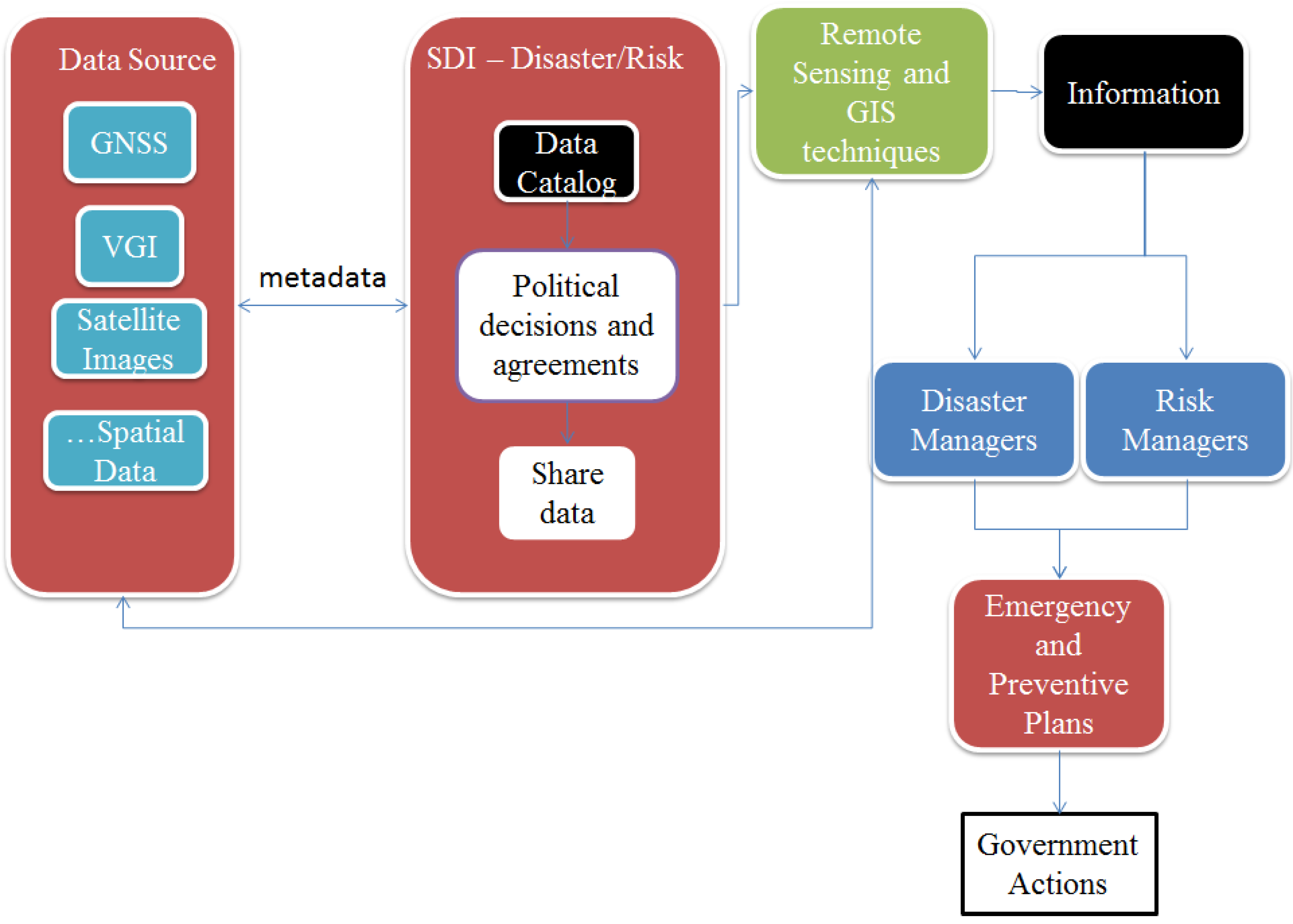
Figure 1 presents a proposal for the organized use of VGI, RS and GNSS data for risk and natural disaster management. To facilitate data availability, an SDI should be established through political decisions and agreements to permit data sharing. Remote-sensing and GIS techniques permit the transformation of the data into information that will support decision-making by risk and disaster managers. Both the developed methodologies and the created information should be shared through political mechanisms. Sharing methodologies and techniques is an important mechanism for increasing the potential of the data and improving the risk and disaster assessment process. The information generated should be available for direct use by managers and may also be useful in further analyses (emergency and preventive). Therefore, with the relevant information, managers can develop plans and create processes that may decrease the potential damage of severe events.
New arrangements of data integration can be developed to increase the potential for data sharing. In addition, financial support for research in this area should be increased, particularly in developing countries, to contribute to the development of methodologies and techniques and ensure the adequacy of procedures for specific areas and events. To encourage these initiatives, the cost of damage recovery should be determined to demonstrate the amount of money that could be saved by investing in these studies.
The implementation of volunteered geographic information is another important initiative for improving alert systems and aiding emergency plans. The information provided by citizens is important for improving the disaster management system, although citizens should undergo training and the communities in risk areas should have a minimum number of volunteers to provide information and facilitate aid action during severe events.
Figure 1.
Scheme for space-based data use for risk and natural disaster management.
Figure 1.
Scheme for space-based data use for risk and natural disaster management.
Methods to assess the reliability of VGI data must also be established by the scientific community. The proposed inclusion of metadata in SDIs and increased flexibility of VGI data, as well as the necessity of standards, should be better investigated. The determination of VGI metadata could be associated with the potential development of statistical inferences of the reliability of the data, for example, by considering the characteristics of a user or by verifying the volume of data reaffirming the same event.
The implementation of VGI systems for emergency response will enhance the SDI data and improve the response time during crisis. The VGI information should be used not only to help managers to identify the best actions plans, but also to provide citizens’ precious information. The Google Crisis Response [
83] is an example of use of VGI information to transmit to the population the status of the crisis through maps and other tools. This kind of initiative enhances the disaster response and improves the results in post-disaster recovery.
Therefore, the political deals are the first step to achieve high quality results for the application of geospatial technologies in risk and disaster management. It will permit the establishment of an international SDI cooperative, which will facilitate information sharing. However it is important to emphasize that besides providing information with quality it is necessary to ensure the correct interpretation and usage of information. To do so, standardized procedures and well prepared technical staff should be available in order to facilitate the analysis and further actions.

