Fallow Land, Recession and Socio-Demographic Local Contexts: Recent Dynamics in a Mediterranean Urban Fringe


Abstract
1. Introduction
2. Materials and Methods
2.1. Study Area
2.2. Land-Use Indicators
2.3. Data Analysis
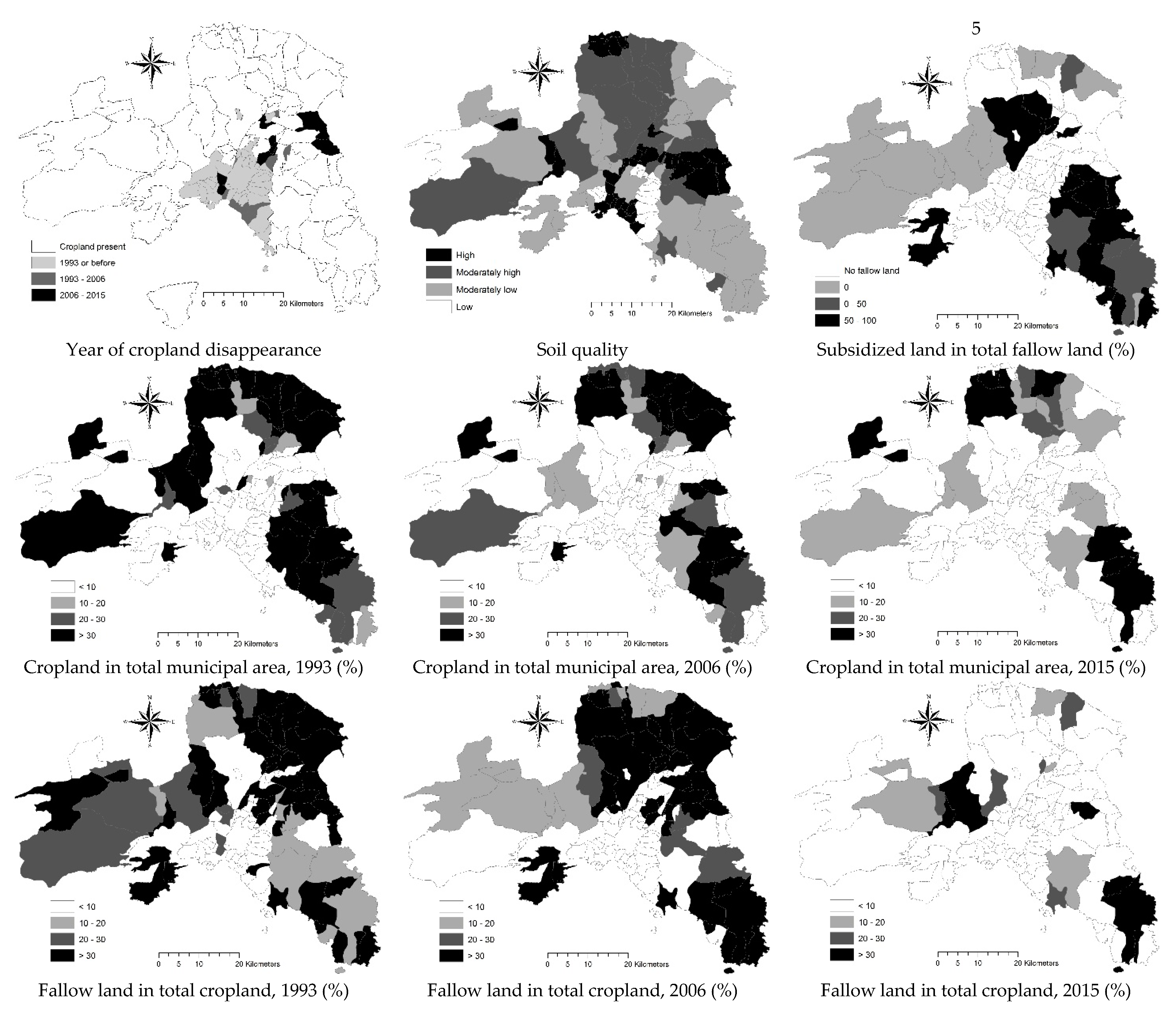
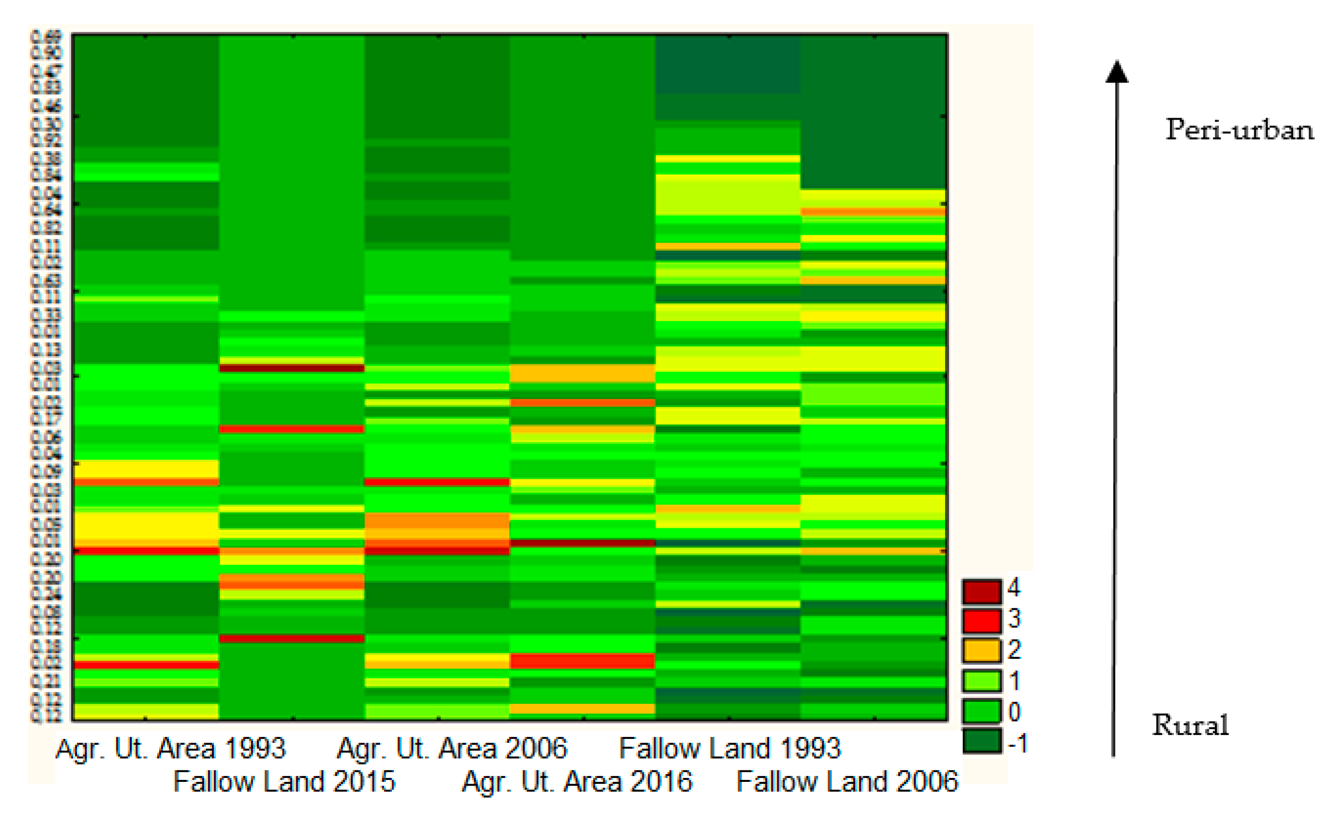
3. Results
3.1. Trends over Time in Total Cropland and Basic Classes of Rural Land-Use Including Fallow Land in Attica
3.2. Spatial Distribution of Total Cropland and Fallow Land in Attica
3.3. Results of a Two-Way Clustering
3.4. Spearman Rank Correlation Analysis
4. Discussion
5. Conclusions
Author Contributions
Funding
Conflicts of Interest
References
- Nuissl, H.; Haase, D.; Lanzendorf, M.; Wittmer, H. Environmental impact assessment of urban land use transitions—A context-sensitive approach. Land Use Policy 2009, 26, 414–424. [Google Scholar] [CrossRef]
- Wu, K.Y.; Zhang, H. Land use dynamics, built-up land expansion patterns, and driving forces analysis of the fast-growing Hangzhou metropolitan area, eastern China (1978–2008). Appl. Geogr. 2012, 34, 137–145. [Google Scholar] [CrossRef]
- Boubaker, K.; Colantoni, A.; Marucci, A.; Longo, L.; Gambella, F.; Cividino, S.; Cecchini, M. Perspective and potential of CO2: A focus on potentials for renewable energy conversion in the Mediterranean basin. Renew. Energy 2016, 90, 248–256. [Google Scholar] [CrossRef]
- Delfanti, L.; Colantoni, A.; Recanatesi, F.; Bencardino, M.; Sateriano, A.; Zambon, I.; Salvati, L. Solar plants, environmental degradation and local socioeconomic contexts: A case study in a Mediterranean country. EIA Rev. 2016, 61, 88–93. [Google Scholar] [CrossRef]
- Colantoni, A.; Allegrini, E.; Boubaker, K.; Longo, L.; Di Giacinto, S.; Biondi, P. New insights for renewable energy hybrid photovoltaic/wind installations in Tunisia through a mathematical model. Energy Convers. Manag. 2013, 75, 398–401. [Google Scholar] [CrossRef]
- Marucci, A.; Zambon, I.; Colantoni, A.; Monarca, D. A combination of agricultural and energy purposes: Evaluation of a prototype of photovoltaic greenhouse tunnel. Renew. Sustain. Energy Rev. 2018, 82, 1178–1186. [Google Scholar] [CrossRef]
- Marucci, A.; Colantoni, A.; Zambon, I.; Egidi, G. Precision farming in hilly areas: The use of network RTK in GNSS technology. Agriculture 2017, 7, 60. [Google Scholar] [CrossRef]
- Zambon, I.; Monarca, D.; Cecchini, M.; Bedini, R.; Longo, L.; Romagnoli, M.; Marucci, A. Alternative energy and the development of local rural contexts: An approach to improve the degree of smart cities in the Central-Southern Italy. Contemp. Eng. Sci. 2016, 9, 1371–1386. [Google Scholar] [CrossRef]
- Estel, S.; Kuemmerle, T.; Alcántara, C.; Levers, C.; Prishchepov, A.; Hostert, P. Mapping farmland abandonment and recultivation across Europe using MODIS NDVI time series. Remote. Sens. Environ. 2015, 163, 312–325. [Google Scholar] [CrossRef]
- Kuemmerle, T.; Erb, K.; Meyfroidt, P.; Müller, D.; Verburg, P.H.; Estel, S.; Levers, C. Challenges and opportunities in mapping land use intensity globally. Curr. Opin. Environ. Sustain. 2015, 5, 484–493. [Google Scholar] [CrossRef] [PubMed]
- Primdahl, J.; Peco, B.; Schramek, J.; Andersen, E.; Oñate, J.J. Environmental effects of agri-environmental schemes in Western Europe. J. Environ. Manag. 2003, 67, 129–138. [Google Scholar] [CrossRef]
- Colantoni, A.; Ferrara, C.; Perini, L.; Salvati, L. Assessing Trends in Climate Aridity and Vulnerability to Soil Degradation in Italy. Ecol. Indic. 2015, 48, 599–604. [Google Scholar] [CrossRef]
- Tanrivermis, H. Agricultural land use change and sustainable use of land resources in the Mediterranean region of Turkey. J. Arid. Environ. 2003, 54, 553–564. [Google Scholar] [CrossRef]
- Garcia Latorre, J.; Garcia-Latorre, J.; Sanchez-Picon, A. Dealing with aridity: Socio-economic structures and environmental changes in an arid Mediterranean region. Land Use Policy 2001, 18, 53–64. [Google Scholar] [CrossRef]
- Schneider, A.; Woodcock, C.E. Compact, dispersed, fragmented, extensive? A comparison of urban growth in twenty-five global cities using remotely sensed data, pattern metrics and census information. Urban Stud. 2008, 45, 659–692. [Google Scholar] [CrossRef]
- Colantoni, A.; Grigoriadis, E.; Sateriano, A.; Venanzoni, G.; Salvati, L. Cities as selective land predators? A lesson on urban growth, deregulated planning and sprawl containment. Sci. Total. Environ. 2016, 545, 329–339. [Google Scholar] [CrossRef] [PubMed]
- Ceccarelli, T.; Bajocco, S.; Perini, L.; Salvati, L. Urbanisation and Land Take of High Quality Agricultural Soils—Exploring Long-term Land Use Changes and Land Capability in Northern Italy. Int. J. Environ. Res. 2014, 8, 181–192. [Google Scholar]
- Arapoglou, V.P.; Sayas, J. New facets of urban segregation in southern Europe. Eur. Urban Reg. Stud. 2009, 16, 345–362. [Google Scholar] [CrossRef]
- Di Feliciantonio, C.; Salvati, L. ‘Southern’ alternatives of urban diffusion: Investigating settlement characteristics and socioeconomic patterns in three Mediterranean regions. Tijdschr. Econ. Soc. Geogr. 2015, 106, 453–470. [Google Scholar] [CrossRef]
- Maloutas, T. Segregation and residential mobility: Spatially entrapped social mobility and its impact on segregation in Athens. Eur. Urban Reg. Stud. 2004, 11, 195–211. [Google Scholar] [CrossRef]
- Carlucci, M.; Grigoriadis, E.; Rontos, K.; Salvati, L. Revisiting an Hegemonic Concept: Long-term ‘Mediterranean Urbanization’ in between city re-polarization and metropolitan decline. Appl. Spat. Anal. Policy 2017, 10, 347–362. [Google Scholar] [CrossRef]
- Chorianopoulos, I.; Pagonis, T.; Koukoulas, S.; Drymoniti, S. Planning, competitiveness and sprawl in the Mediterranean city: The case of Athens. Cities 2010, 27, 249–259. [Google Scholar] [CrossRef]
- Chorianopoulos, I.; Tsilimigkas, G.; Koukoulas, S.; Balatsos, T. The shift to competitiveness and a new phase of sprawl in the Mediterranean city: Enterprises guiding growth in Messoghia—Athens. Cities 2014, 39, 133–143. [Google Scholar] [CrossRef]
- Rontos, K.; Grigoriadis, E.; Sateriano, A.; Syrmali, M.; Vavouras, I.; Salvati, L. Lost in protest, found in segregation: Divided cities in the light of the 2015 “Οχι” referendum in Greece. City Cult. Soc. 2016, 7, 139–148. [Google Scholar] [CrossRef]
- Souliotis, N. Cultural economy, sovereign debt crisis and the importance of local contexts: The case of Athens. Cities 2013, 33, 61–68. [Google Scholar] [CrossRef]
- Zitti, M.; Ferrara, C.; Perini, L.; Carlucci, M.; Salvati, L. Long-term urban growth and land use efficiency in Southern Europe: Implications for sustainable land management. Sustainability 2015, 7, 3359–3385. [Google Scholar] [CrossRef]
- Gospodini, A. Portraying, classifying and understanding the emerging landscapes in the post-industrial city. Cities 2006, 23, 311–330. [Google Scholar] [CrossRef]
- European Environment Agency. Mapping Guide for a European Urban Atlas. Copenhagen. Available online: http://www.eea.europa.eu/data-and-maps/data/urban-atlas (accessed on 11 December 2017).
- Cecchini, M.; Zambon, I.; Pontrandolfi, A.; Turco, R.; Colantoni, A.; Mavrakis, A.; Salvati, L. Urban Sprawl and the ‘olive’landscape: Sustainable land management for ‘crisis’ cities. GeoJournal 2018, 1–19. [Google Scholar]
- Zambon, I.; Sauri, D.; Serra, P.; Carlucci, M.; Salvati, L. Beyond the ‘Mediterranean city’: Socioeconomic disparities and urban sprawl in three Southern European cities. Geogr. Ann. Ser. B Hum. Geogr. 2017, 99, 319–337. [Google Scholar] [CrossRef]
- Gargiulo, M.V.; Rontos, K.; Salvati, L. Between suburbanisation and re-urbanisation? Revisiting the Urban Life Cycle in a Mediterranean Compact City. Urban Res. Pract. 2014, 7, 74–88. [Google Scholar]
- Kallis, G. Co-evolution in water resource development. The vicious cycle of water supply and demand in Athens, Greece. Ecol. Econ. 2010, 69, 796–809. [Google Scholar] [CrossRef]
- Kaika, M. The economic crisis seen from the everyday. City 2012, 16, 422–430. [Google Scholar] [CrossRef]
- De Rosa, S.; Salvati, L. Beyond a ‘side street story’? Naples from spontaneous centrality to entropic polycentricism, towards a ‘crisis city’. Cities 2016, 51, 74–83. [Google Scholar] [CrossRef]
- Gkartzios, M.; Remoundou, K.; Garrod, G. Emerging geographies of mobility: The role of regional towns in Greece’s ‘counterurbanisation story’. J. Rural. Stud. 2017, 55, 22–32. [Google Scholar] [CrossRef]
- Gkartzios, M.; Scott, K. A Cultural Panic in the Province? Counterurban Mobilities, Creativity, and Crisis in Greece. Popul. Space Place 2015, 21, 843–855. [Google Scholar] [CrossRef]
- Aretano, R.; Petrosillo, I.; Zaccarelli, N.; Semeraro, T.; Zurlini, G. People perception of landscape change effects on ecosystem services in small Mediterranean islands: A combination of subjective and objective assessments. Landsc. Urban Plan. 2013, 112, 63–73. [Google Scholar] [CrossRef]
- Beriatos, E.; Gospodini, A. Glocalising urban landscapes: Athens and the 2004 Olympics. Cities 2004, 21, 187–202. [Google Scholar] [CrossRef]
- Biasi, R.; Brunori, E.; Smiraglia, D.; Salvati, L. Linking traditional tree-crop landscapes and agro-biodiversity in Central Italy using a database of typical and traditional products: A multiple risk assessment through a data mining analysis. Biodivers. Conserv. 2015, 24, 3009–3031. [Google Scholar] [CrossRef]
- Biasi, R.; Colantoni, A.; Ferrara, C.; Ranalli, F.; Salvati, L. In-between Sprawl and Fires: Long-term Forest Expansion and Settlement Dynamics at the Wildland-Urban Interface in Rome, Italy. Int. J. Sustain. Dev. World Ecol. 2015, 22, 467–475. [Google Scholar] [CrossRef]
- Cimini, D.; Tomao, A.; Mattioli, W.; Barbati, A.; Corona, P. Assessing impact of forest cover change dynamics on high nature value farmland in Mediterranean mountain landscape. Ann. Silvic. Res. 2013, 37, 29–37. [Google Scholar]
- Cohen, M.; Bilodeau, C.; Alexandre, F.; Godron, M.; Andrieu, J.; Gresillon, E.; Garlatti, F.; Morganti, A. What is the plant biodiversity in a cultural landscape? A comparative, multi-scale and interdisciplinary study in olive groves and vineyards (Mediterranean France). Agric. Ecosyst. Environ. 2015, 212, 175–186. [Google Scholar] [CrossRef]
- Economidou, E. The Attic landscape throughout the centuries and its human degradation. Landsc. Urban Plan. 1993, 24, 33–37. [Google Scholar] [CrossRef]
- Kizos, T.; Vakoufaris, H. Valorisation of local asset: The case of olive oil on Lesvos Island, Greece. Food Policy 2011, 36, 705–714. [Google Scholar] [CrossRef]
- Kristensen, S.P.; Thenail, C.; Kristensen, L. Farmers’ involvement in landscape: An analysis of the relationship between farm location, farm characteristics and landscape changes in two study areas in Jutlund, Denmark. J. Environ. Manag. 2001, 61, 301–318. [Google Scholar] [CrossRef] [PubMed]
- Raudsepp-Hearne, C.; Peterson, G.D.; Bennett, E.M. Ecosystem service bundles for analyzing tradeoffs in diverse landscapes. Proc. Natl. Acad. Sci. USA 2010, 107, 5242–5247. [Google Scholar] [CrossRef] [PubMed]
- Salvati, L. Agro-forest landscape and the ‘fringe’ city: A multivariate assessment of land-use changes in a sprawling region and implications for planning. Sci. Total. Environ. 2014, 490, 715–723. [Google Scholar] [CrossRef] [PubMed]
- Serra, P.; Pons, X.; Saurì, D. Land-cover and land-use change in a Mediterranean landscape: A spatial analysis of driving forces integrating biophysical and human factors. Appl. Geogr. 2008, 28, 189–209. [Google Scholar] [CrossRef]
- Tsilimigkas, G.; Kizos, T. Space, pressures and the management of the Greek landscape. Geogr. Ann. Ser. B Hum. Geogr. 2014, 96, 159–175. [Google Scholar] [CrossRef]
- Vieri, M. Traditional olive crop mechanization in areas with a high landscape value. Results of tests with new olive picking equipment. Adv. Hortic. Sci. 2002, 16, 235–239. [Google Scholar]
- Zambon, I.; Ferrara, A.; Salvia, R.; Mosconi, E.M.; Fici, L.; Turco, R.; Salvati, L. Rural Districts between Urbanization and Land Abandonment: Undermining Long-Term Changes in Mediterranean Landscapes. Sustainability 2018, 10, 1159. [Google Scholar] [CrossRef]
- Orsini, S. Landscape polarisation, hobby farmers and valuable hills in Tuscany: Understanding landscape dynamics in a peri-urban context. Geogr. Tidsskr. Dan. J. Geogr. 2013, 113, 54–64. [Google Scholar] [CrossRef]
- Moissidis, A.; Duquenne, M.-N. Peri-urban rural areas in Greece: The case of Attica. Sociol. Rural. 1997, 37, 228–239. [Google Scholar] [CrossRef]
- Gkartzios, M. ‘Leaving Athens’: Narratives of counterurbanisation in times of crisis. J. Rural. Stud. 2013, 32, 158–167. [Google Scholar] [CrossRef]
- Delladetsima, P.M. The emerging property development pattern in Greece and its impact on spatial development. Eur. Urban Reg. Stud. 2006, 13, 245–278. [Google Scholar] [CrossRef]
- Giannakourou, G. Planning regulation, property protection, and regulatory takings in the Greek planning law. Wash. Univ. Glob. Stud. Law Rev. 2006, 5, 534–557. [Google Scholar]
- Cuadrado-Ciuraneta, S.; Durà-Guimerà, A.; Salvati, L. Not only tourism: Unravelling suburbanization, second-home expansion and “rural” sprawl in Catalonia, Spain. Urban Geogr. 2017, 38, 66–89. [Google Scholar] [CrossRef]
- Serra, P.; Vera, A.; Tulla, A.F.; Salvati, L. Beyond urban-rural dichotomy: Exploring socioeconomic and land-use processes of change in Spain (1991–2011). Appl. Geogr. 2014, 55, 71–81. [Google Scholar] [CrossRef]
- Almeida, A.; Figueiredo, T.; Fernandes-Silva, A. Evolution of factors affecting mechanical olive harvesting. Acta Hortic. 2016, 1139, 575–579. [Google Scholar] [CrossRef]
- Calabrese, G.; Tartaglini, N.; Ladisa, G. Study on Biodiversity in Century-Old Olive Groves; CIHEAM-Mediterranean Agronomic Institute: Bari, Italy, 2012. [Google Scholar]
- Famiani, F.; Farinelli, D.; Rollo, S.; Camposeo, S.; Di Vaio, C.; Inglese, P. Evaluation of different mechanical fruit harvesting systems and oil quality in very large size olive trees. Span. J. Agric. Res. 2014, 12, 960–997. [Google Scholar] [CrossRef]
- Gutierrez, A.P.; Ponti, L.; Cossu, Q.A. Effects of climate warming on Olive and olive fly (Bactrocera oleae Gmelin) in California and Italy. Clim. Chang. 2009, 95, 195–217. [Google Scholar] [CrossRef]
- Kizos, T. Multifunctionality of farm households in Greece. Nor. Geogr. Tidsskr. Nor. J. Geogr. 2010, 64, 105–116. [Google Scholar] [CrossRef]
- Kizos, T.; Vasdeki, M.; Chatzikiriakou, C.; Dimitriou, D. ‘For my children’: Different functions of the agricultural landscape and attitudes of farmers on different areas of Greece towards small scale landscape change. Geogr. Tidsskr. Dan. J. Geogr. 2011, 111, 117–130. [Google Scholar] [CrossRef]
- Loumou, A.; Giourga, C. Olive groves: ‘The life and identity of Mediterranean’. Agric. Hum. Values 2003, 20, 87–95. [Google Scholar] [CrossRef]
- Meneley, A. Extra Virgin Olive Oil and Slow Food. Anthropologica 2004, 46, 165–176. [Google Scholar] [CrossRef]
- Palazzo, A.L.; Aristone, O. Peri-Urban Matters. Changing Olive Growing Patterns in Central Italy. Sustainability 2017, 9, 638. [Google Scholar] [CrossRef]
- Tanasijevic, L.; Todorovic, M.; Pereira, L.S.; Pizzigalli, C.; Lionello, P. Impacts of climate change on olive crop evapotranspiration and irrigation requirements in the Mediterranean region. Agric. Water Manag. 2014, 144, 54–68. [Google Scholar] [CrossRef]
- Makhzoumi, J.M. The changing role of rural landscapes: Olive and carob multi-use tree plantations in the semiarid Mediterranean. Landsc. Urban Plan. 1997, 37, 115–122. [Google Scholar] [CrossRef]
- Paetzold, A.; Warren, P.H.; Maltby, L.L. A framework for assessing ecological quality based on ecosystem services. Ecol. Complex. 2010, 7, 273–281. [Google Scholar] [CrossRef]
- Duvernoy, I.; Zambon, I.; Sateriano, A.; Salvati, L. Pictures from the Other Side of the Fringe: Urban Growth and Peri-urban Agriculture in a Post-industrial City (Toulouse, France). J. Rural. Stud. 2018, 57, 25–35. [Google Scholar] [CrossRef]
- Newman, L.; Powell, L.J.; Nickel, J.; Anderson, D.; Jovanovic, L.; Mendez, E.; Kelly-Freiberg, K. Farm stores in agriburbia: The roles of agricultural retail on the rural-urban fringe. Canadian Food Studies/La Revue Canadienne des Études sur L’alimentation 2017, 4, 4–23. [Google Scholar] [CrossRef]
- Sandul, P.J. The agriburb: Recalling the suburban side of ontario, california’s agricultural colonization. Agric. Hist. 2010, 84, 195–223. [Google Scholar] [CrossRef] [PubMed]
- Le Houérou, H.N. Land degradation in Mediterranean Europe: Can agroforestry be a part of the solution? A prospective review. Agrofor. Syst. 1993, 21, 43–61. [Google Scholar] [CrossRef]
- Brunori, E.; Farina, R.; Biasi, R. Sustainable viticulture: The carbon-sink function of the vineyard agro-ecosystem. Agric. Ecosyst. Environ. 2016, 223, 10–21. [Google Scholar] [CrossRef]
- Giourga, C.; Loumou, A. Assessing the impact of pluriactivity on sustainable agriculture. A case study in rural areas of Beotia in Greece. Environ. Manag. 2006, 37, 753–763. [Google Scholar] [CrossRef] [PubMed]
- Monarca, D.; Cecchini, M.; Colantoni, A.; Di Giacinto, S.; Menghini, G.; Longo, L. Study on the possibility of application of a compact roll over protective structure for agricultural wheeled narrow track tractors. J. Agric. Eng. 2013, 44, e136. [Google Scholar] [CrossRef]
- Mousazadeh, H.; Keyhani, A.; Mobli, H.; Bardi, U.; El Asmar, T. Sustainability in agricultural mechanization: Assessment of a combined photovoltaic and electric multipurpose system for farmers. Sustainability 2009, 1, 1042–1068. [Google Scholar] [CrossRef]
- Portnov, B.A.; Safriel, U.N. Combating desertification in the Negev: Dryland agriculture vs. dryland urbanization. J. Arid Environ. 2004, 56, 659–680. [Google Scholar] [CrossRef]
- Savo, V.; Caneva, G.; McClatchey, W.; Reedy, D.; Salvati, L. Combining environmental factors and agriculturalists’ observations of environmental changes in the traditional terrace system of the Amalfi Coast (Southern Italy). Ambio 2014, 43, 297–310. [Google Scholar] [CrossRef] [PubMed]
- Colantoni, A.; Cecchini, M.; Monarca, D.; Bedini, R.; Riccioni, S. The risk of musculoskeletal disorders due to repetitive movements of upper limbs for workers employed in hazelnut sorting. J. Agric. Eng. Res. 2013, 44. [Google Scholar] [CrossRef]
- Monarca, D.; Cecchini, M.; Colantoni, A.; Marucci, A. Feasibility of the electric energy production through gasification processes of biomass: Technical and economic aspects. In Proceedings of the International Conference on Computational Science and Its Applications, Santander, Spain, 20–23 June 2011; Springer: Berlin/Heidelberg, Germany, 2011; pp. 307–315. [Google Scholar]
- Monarca, D.; Cecchini, M.; Guerrieri, M.; Colantoni, A. Conventional and alternative use of biomasses derived by hazelnut cultivation and processing. Acta Horticult. 2008, 845, 27–634. [Google Scholar] [CrossRef]
- Amato, F.; Maimone, B.A.; Martellozzo, F.; Nolè, G.; Murgante, B. The Effects of Urban Policies on the Development of Urban Areas. Sustainability 2016, 8, 297. [Google Scholar] [CrossRef]
- Amato, F.; Tonini, M.; Murgante, B.; Kanevski, M. Fuzzy definition of Rural Urban Interface: An application based on land use change scenarios in Portugal. Environ. Model. Softw. 2018, 104, 171–187. [Google Scholar] [CrossRef]
- Aubry, R.J.; Abat, M.-H.; Ramamonjisoa, J.; Dabat, M.H.; Rakotoarisoa, J.; Rakotondraibe, J.; Rabeharisoa, L. Urban agriculture and land use in cities: An approach with multi-functionality and sustainsability concepts in the case of Antananarivo (Madagascar). Land Use Policy 2012, 29, 429–439. [Google Scholar] [CrossRef]
- Audsley, E.; Pearn, K.R.; Simota, C.; Cojocaru, G.; Koutsidou, E.; Rounsevell, M.D.A.; Trnka, M.; Alexandrov, V. What can scenario modelling tell us aboutfuture European scale agricultural land use and what not? Environ. Sci. Policy 2006, 9, 148–162. [Google Scholar] [CrossRef]
- Giannakourou, G. Transforming spatial planning policy in Mediterranean countries: Europeanization and domestic change. Eur. Plan. Stud. 2005, 13, 319–331. [Google Scholar] [CrossRef]
- Kelly, C.; Ferrara, A.; Wilson, G.A.; Ripullone, F.; Nolè, A.; Harmer, N.; Salvati, L. Community resilience and land degradation in forest and shrubland socio-ecological systems: Evidence in Gorgoglione, Basilicata, Italy. Land Use Policy 2015, 46, 11–20. [Google Scholar] [CrossRef]
- Mosquera-Losada, M.R.; Santiago Freijanes, J.J.; Pisanelli, A.; Rois, M.; Smith, J.; den Herder, M.; Ferreiro Domínguez, N. Extent and Success of Current Policy Measures to Promote Agroforestry Across Europe; Agforward European Project Policy Report; Agforward: Cranfield, UK, 2012. [Google Scholar]
- Paul, V.; Haslam Mckenzie, F. Peri-urban farmland conservation and development of alternative food networks: Insights from a case study area in metropolitan Barcelona (Catalonia, Spain). Land Use Policy 2013, 30, 94–105. [Google Scholar] [CrossRef]


| Year | Total Crops | Arable Land | Garden Crop | Vineyards | Tree Crop | Fallow Land | Total Crops | Arable Land | Garden Crop | Vineyards | Tree Crop | Fallow Land |
|---|---|---|---|---|---|---|---|---|---|---|---|---|
| Greater Athens’ area | Rural Attica | |||||||||||
| 1970 | 4.2 | 19.9 | 38.6 | 4.4 | 12.3 | 24.8 | 42.5 | 22.0 | 5.4 | 16.6 | 22.8 | 33.2 |
| 1979 | 3.2 | 15.6 | 35.0 | 4.2 | 18.7 | 26.4 | 39.6 | 19.5 | 4.7 | 17.1 | 26.5 | 32.2 |
| 1988 | 2.9 | 12.3 | 28.0 | 3.2 | 16.1 | 40.5 | 38.3 | 18.7 | 6.0 | 15.5 | 29.2 | 30.6 |
| 1997 | 2.2 | 14.6 | 5.6 | 12.0 | 32.1 | 35.6 | 38.0 | 14.6 | 5.6 | 12.0 | 32.1 | 35.6 |
| 2006 | 0.1 | 0.9 | 25.8 | 13.2 | 12.2 | 47.9 | 29.6 | 13.8 | 7.6 | 9.6 | 34.7 | 34.3 |
| 2015 | 0.1 | 1.3 | 20.5 | 4.3 | 73.9 | 0.0 | 20.2 | 18.5 | 6.0 | 12.2 | 53.2 | 10.0 |
| Attica as a whole | Greece | |||||||||||
| 1970 | 28.9 | 22.0 | 5.8 | 16.4 | 22.7 | 33.1 | 30.9 | 61.9 | 2.6 | 5.4 | 16.6 | 13.4 |
| 1979 | 26.9 | 19.4 | 5.2 | 16.9 | 26.4 | 32.1 | 31.0 | 60.0 | 2.8 | 4.8 | 19.6 | 12.8 |
| 1988 | 26.0 | 18.6 | 6.4 | 15.3 | 29.0 | 30.7 | 30.4 | 59.0 | 2.8 | 4.1 | 22.3 | 11.8 |
| 1997 | 25.7 | 14.5 | 5.8 | 12.0 | 31.9 | 35.8 | 29.8 | 57.6 | 3.1 | 3.4 | 24.4 | 11.5 |
| 2006 | 19.8 | 13.8 | 7.7 | 9.5 | 34.7 | 34.3 | 28.5 | 55.3 | 3.0 | 3.4 | 26.9 | 11.4 |
| 2015 | 13.5 | 18.5 | 6.1 | 12.2 | 53.2 | 10.0 | 24.9 | 52.9 | 2.1 | 2.9 | 31.0 | 11.2 |
| Variable | Utilized Agricultural Area | Fallow Land in Total Cropland | Subsidized Land | ||||
|---|---|---|---|---|---|---|---|
| 1993 | 2006 | 2015 | 1993 | 2006 | 2015 | In Total Fallow Land | |
| Population density | −0.60 | −0.67 | −0.74 | −0.42 | −0.47 | −0.49 | |
| Forests in total landscape | 0.44 | ||||||
| Per-capita built-up area | 0.74 | 0.48 | 0.46 | ||||
| Distance from Athens | 0.53 | 0.64 | 0.69 | 0.43 | |||
| Distance from Piraeus | 0.50 | 0.60 | 0.64 | ||||
| Distance from Maroussi | 0.50 | 0.57 | 0.42 | ||||
| Distance from Markopoulo Me. | −0.65 | ||||||
| Municipal area | 0.46 | 0.56 | 0.52 | ||||
| Per-capita declared income (log) | −0.45 | 0.65 | |||||
| Self-contained workers | 0.50 | 0.51 | 0.59 | ||||
| Self-contained population | −0.60 | ||||||
| Per cent rate of non-native population born in Europe | 0.61 | ||||||
© 2018 by the authors. Licensee MDPI, Basel, Switzerland. This article is an open access article distributed under the terms and conditions of the Creative Commons Attribution (CC BY) license (http://creativecommons.org/licenses/by/4.0/).
Share and Cite
Zambon, I.; Serra, P.; Salvia, R.; Salvati, L. Fallow Land, Recession and Socio-Demographic Local Contexts: Recent Dynamics in a Mediterranean Urban Fringe. Agriculture 2018, 8, 159. https://doi.org/10.3390/agriculture8100159
Zambon I, Serra P, Salvia R, Salvati L. Fallow Land, Recession and Socio-Demographic Local Contexts: Recent Dynamics in a Mediterranean Urban Fringe. Agriculture. 2018; 8(10):159. https://doi.org/10.3390/agriculture8100159
Chicago/Turabian StyleZambon, Ilaria, Pere Serra, Rosanna Salvia, and Luca Salvati. 2018. "Fallow Land, Recession and Socio-Demographic Local Contexts: Recent Dynamics in a Mediterranean Urban Fringe" Agriculture 8, no. 10: 159. https://doi.org/10.3390/agriculture8100159
APA StyleZambon, I., Serra, P., Salvia, R., & Salvati, L. (2018). Fallow Land, Recession and Socio-Demographic Local Contexts: Recent Dynamics in a Mediterranean Urban Fringe. Agriculture, 8(10), 159. https://doi.org/10.3390/agriculture8100159