
Analysis and Diagnosis of the Agrarian System in the Niayes Region, Northwest Senegal (West Africa)

Abstract
:1. Introduction
- Understanding conditions of market gardening development in the Niayes (environmental parameters: Soil fertility, water resources, etc.) and the diversity of production units in this region to fine-tune forthcoming projects.
- Determining the conditions necessary for the Niayes to better contribute to the country’s agricultural production. Beyond technological choices, we had to understand the economic rationality of Niayes’ production units. Understanding their rationality will help this project to better suggest social, economic and political actions that would be able to boost production and create jobs while respecting the environment.
2. Materials and Methods
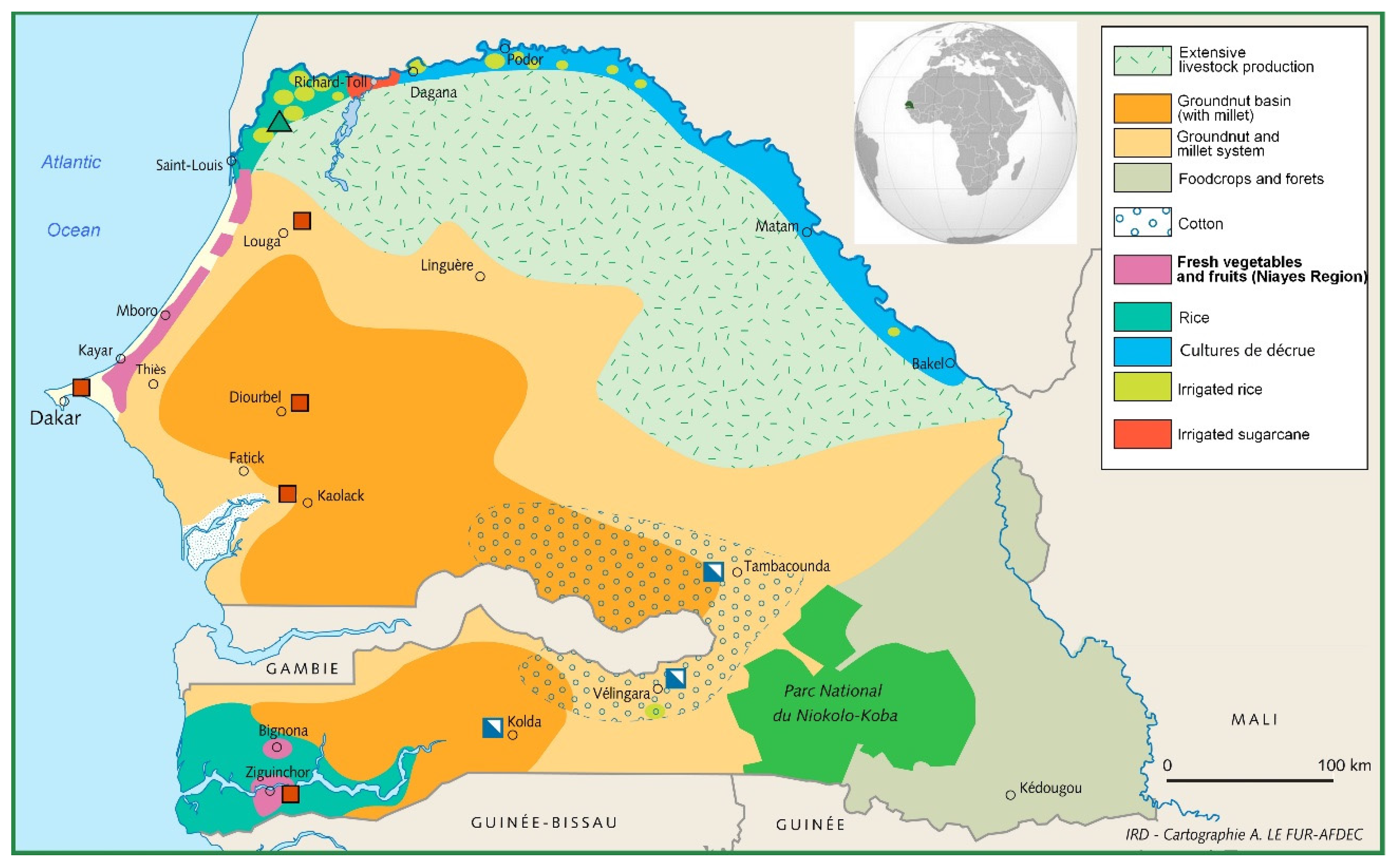
2.1. The Survey Area
2.1.1. Boundaries
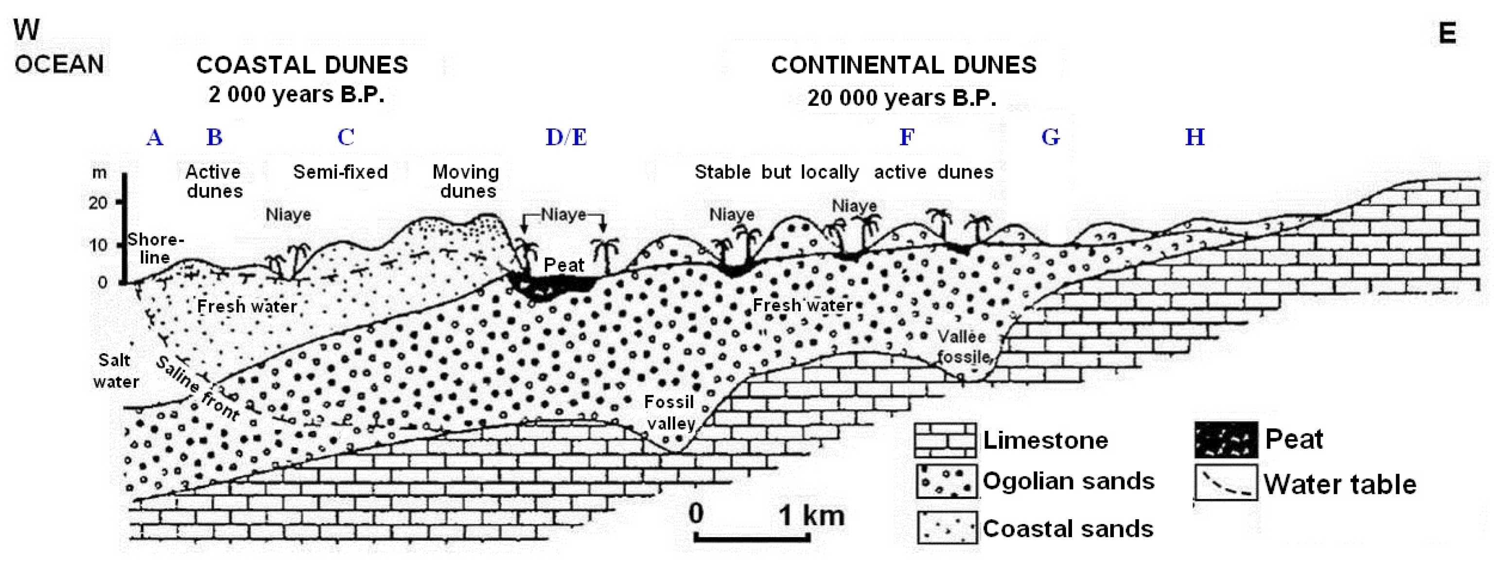
- Long red and levelled dunes, oriented from northeast to southwest, running parallel with the shore line, witnessing the regressive and dry phase (Ogolien) of the last ice age (18,000 years ago). These dunes are steady and indicate the borders of the Niayes and the Dieri (the local name for the ancient peanut basin).
- Shorter and higher red dunes, sheltering much more than anywhere else humus-bearing soils and peat bogs. These dunes would be resulting from Ogolian dunes alteration by a marine tradewind [16]. They are in general permanent but revive in some places.
- Semi-permanent yellow dunes, forming a coastal dune stretch with variable width from one to four kilometres. Of 20 to 30 m high, they end with an abrupt front in the windy part. They would have been settled in the regressive phase after 5500 BCE. The depressions between dunes bear less humus [16].
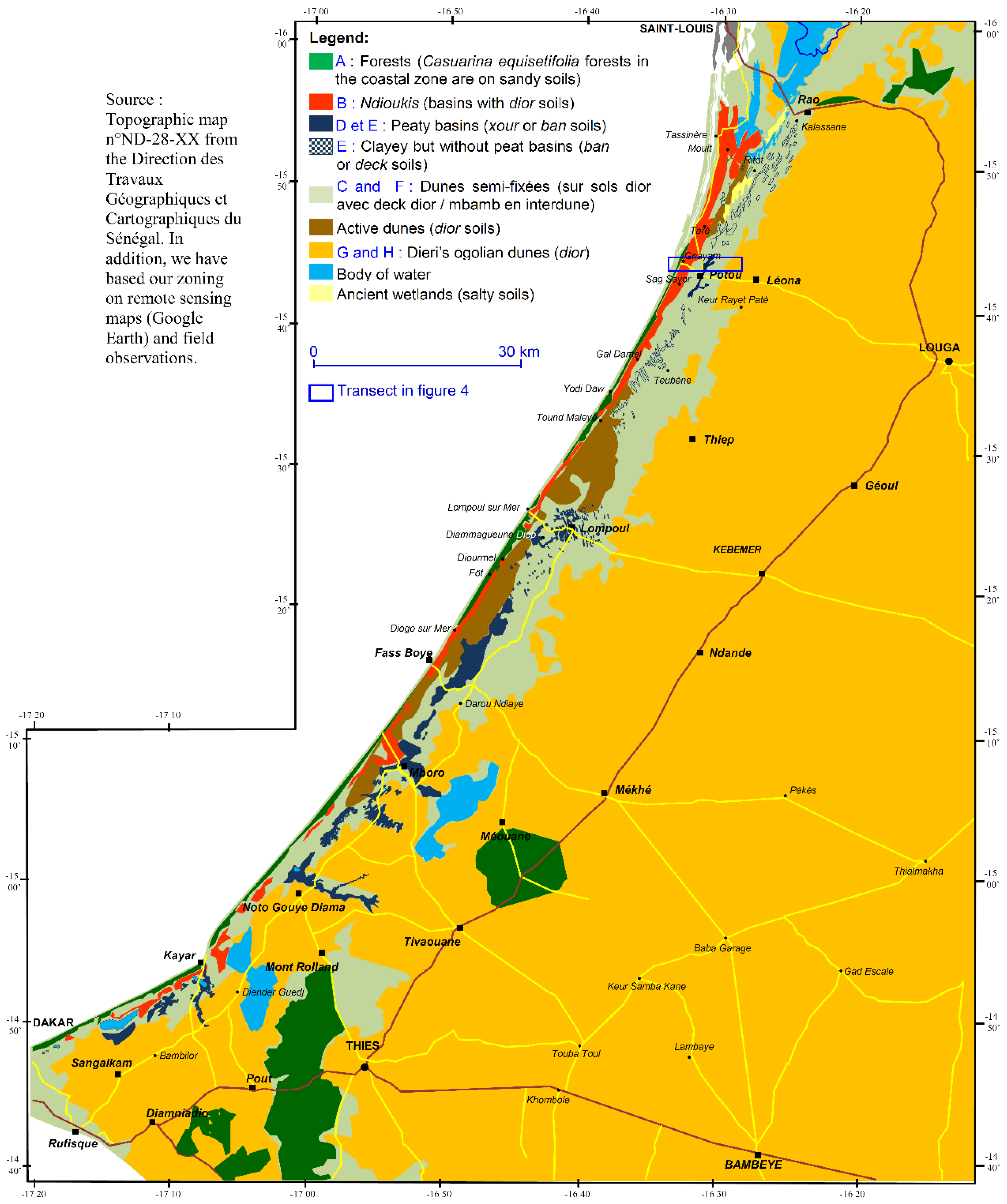
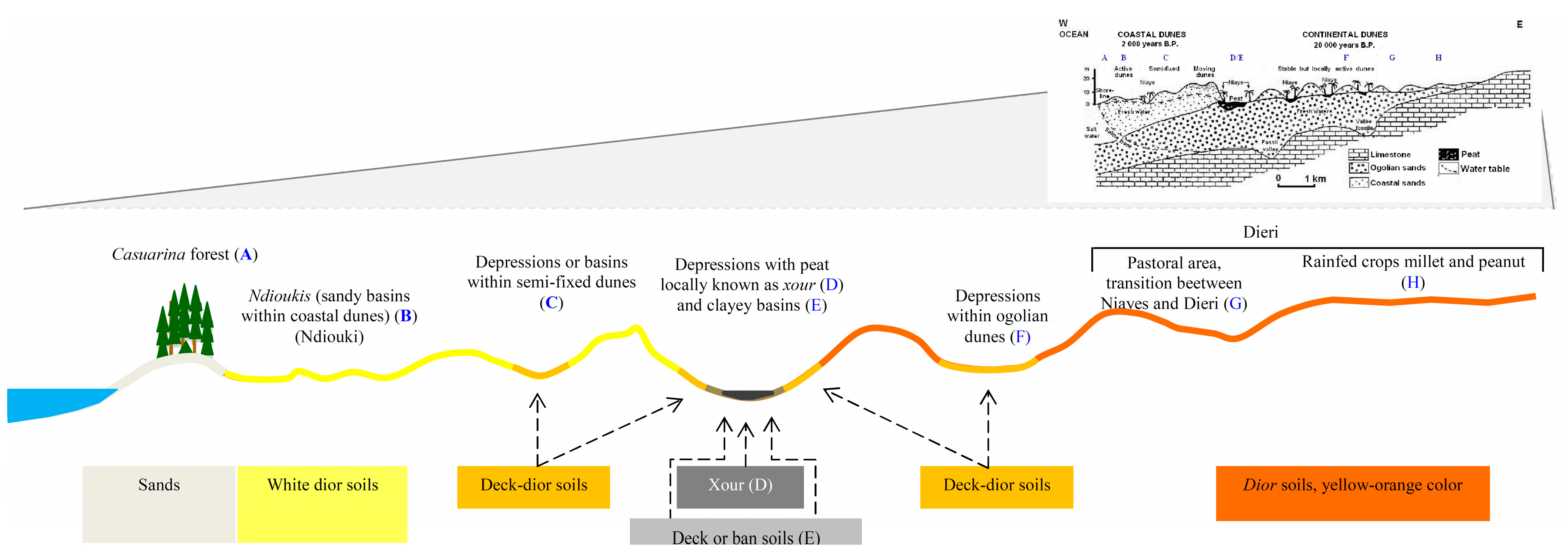
2.1.2. Zoning Elements
- A coastal dune string (A), composed of raw mineral soils. On these dunes, which can be potentially mobilized by wind, colonial forestry administration by the Senegalese government established in successive stages a filao trees strip (Casuarina equisetifolia L.), a vegetal barrier protecting against the sand-silting risk to the basins between dunes.
- Small-sized depressions, between levelled and scarcely collected dunes (B). On this area, which stretches a few hundreds of meters behind the filao trees strip, the groundwater level is not very deep (two to five meters). For that reason, undoubtedly, depressions are named “Ndioukis,” meaning “drawing water with a bucket using a pulley.” Soils are of a siliceous type, poor in organic materials and sometimes salinated. Ndioukis are much more numerous in the North of the Niayes (Northern zone: from the South of Saint Louis to the Lompoul s/mer-Kebemer axis; Central zone: between Lompoul-Kebemer axis and Kayar-Thies axis (corresponding to the Eastern boundary and Cape Verde Peninsula: Southern zone: East of the Cape Verte Peninsula, Keur Moussa, Sébikotane, Bayakh, Diender).
- A dune area partly fixed by scarce shrubby and wooded vegetation, with sandy-soiled inter-dune depressions, slightly moist and of ochre colour. This area (C) covers the intermediate part of Niayes (from 300 to 2000 m towards lands, to the west). Depressions are of varied sizes and forms.
- The ancient riverbed or lake zones (D and E) resulting in large depressions; the NSQ is at grounds’ level. Depressions are embanked, clayey or even peaty (local name: xour; we classify them under subzone D) or clayey and muddy soils (called ban in Wolof) (subzone E). The relics of Guinean vegetation can be seen in this area. As we can see in the literature, the term “Niayes” was first associated with this well knows and early populated area. We call this part the “peaty Niayes zone.” The width of that area is much more important in the south and centre than it is in the north (Figure 3).
- The last dunes area, where access to water allows market gardening with adapted drainage means. Soils are of dior type in height and of deck dior in the bottom (F). This constitutes the boundary with the Dieri.
- In the Dieri eastern boundary (G and H), which marks the start of the Senegalese peanut basin, the first subzone (G) is not cultivated but reserved as a livestock way and for forestry produce collection. The ‘H’ area in the diagram (Figure 2) is cultivated with a millet/peanut system under cover of Acacia albida Del.
2.2. Definition of the Agricultural Surface
2.3. Economic Analysis
2.3.1. Evaluation of Performances of Cropping Systems and Livestock Farming System
a = (GP − ICp − Amtp)/hectare
b = (ICnp + Amtnp),
2.3.2. Typology of Production Systems
2.3.3. Evaluation of Performance of Each Type of Production System
A = (GP − ICp − Amtp − land property taxes − rents)/hectare
B = (ICnp + Amtnp + taxes + salaries − subsidies)/family worker.
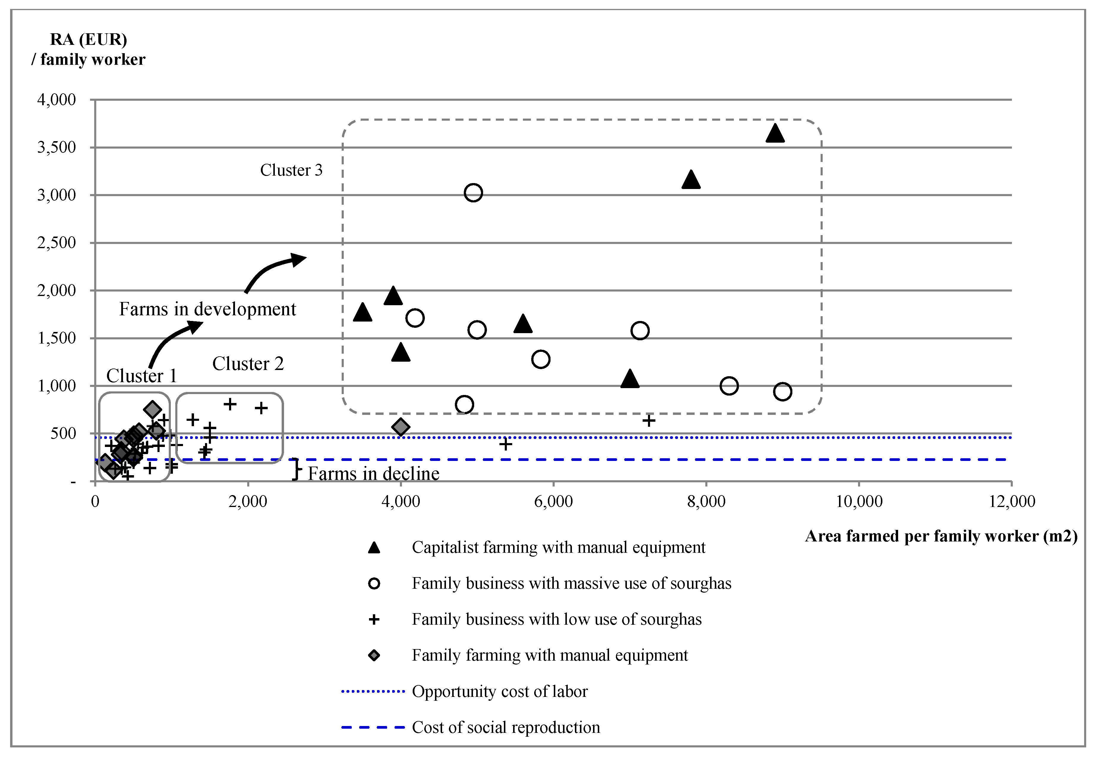
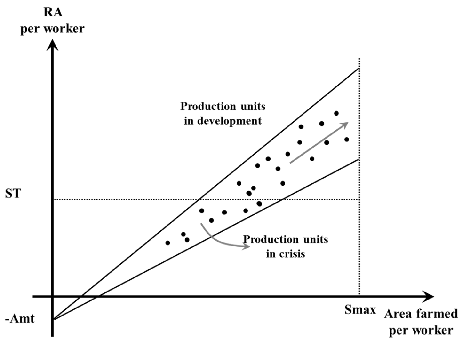
- A survival threshold (ST): such a comparison informs us about the future of the farm and its capacity to develop (Figure 5).
- ○
- If RA > ST, then the production unit is increasing in wealth, which enables the farmer to make some additional net investments.
- ○
- If RA < ST, then the production unit is even less able to make any additional net investments, and cannot even entirely renew its means of production and remunerate its labour power at the market price. Such a farm is in crisis, losing assets and facing basic needs; in the end, it may disappear, shift to another activity (labourers moving to wealthy neighbouring farms), or the owner may choose to migrate.
In the evaluation of this “survival threshold” (per working person and per person to feed within the family) we asked family members what their basic needs were for a given year. - The regional opportunity cost of labour: informs about the economic interest farmers may have in dedicating their work to current production system or a possible shift to another competing activity (e.g., urban migration).
3. Results
3.1. History and Main Features of the Agrarian System
3.1.1. Original Ecosystem
3.1.2. Settling Processes and Pre-Colonial Agriculture
- In the Southern part, a temporary Manding occupation before the 13th century and undoubtedly following the Ghana Empire dislocation. In their raid to the south, they settled around Mont Rolland in the 13th century, where they practiced shifting agriculture and palm tree exploitation in coast. Lebous practiced coastal fishing.
- In the north and centre, towards 1680, Fula from Senegal River (Waalowaalbes) and from the edge of the current Louga (Jeerinkkobes). Hamlets were established along the coast by populations who already know the area due to transhumance: the Niayes provides pasture in the dry season.
- All along the area, Wolofs, after a temporary presence regulated by seasons, were installed in the 18th century to escape instability in the Joloof kingdom and slave raids in the Walo, Cayor and Baol. They occupied the region without established rules and practiced shifting agriculture (millet, peanut with 15 years of fallow lands).
3.1.3. Pre-Colonial Agriculture (Before 1885)
3.1.4. Introduction of New Cultures by Colonial Administration
3.1.5. Fruit and Vegetable Market Development during the Colonial Period (1885–1960)
3.1.6. Impacts of the Drought in the 1970s–1980s
3.1.7. Since 1995, an Increasing Level of Equipment and Production
- Capitalist arrangements (all workers are employees), which little by little concentrated peat bog land in the southern and central zones. They were equipped with powerful motor-pumps and irrigation networks. Watering was done using a hose. Workers receive monthly wages.
- Family businesses (farms with both family workers and employees) in the entire region, of variable size depending on equipment (simple wells using pulley for drainage; small motor-pumps feeding a concrete basin network; big motor-pumps associated with spraying hoses). Workers, sourghas, are fed and accommodated and receive by the end of the year half of the added value.
- Family businesses (all workers are family members), mostly of humble size, with equipment varying from wells to basin networks. They are situated mostly in the central and northern Niayes zones.
3.2. Contemporary Agrarian System Analysis
3.2.1. Determining the Economic Thresholds
3.2.2. Typology of Production Systems
- Main Lebou owners. Installed very close to southern peat bogs’ surrounding, they had access to most fertile lands in Southern Niayes and could develop a more diversified culture and access to motorization by converting a part of land inheritance into money and/or making savings from fish sales.
- Wealthy families descended from Fulani or Toucouleur’s stockbreeders. Established very early in the pasture area (G), they could start market gardening and were at once able to finance campaigns (treasury from stock sales), get materials (transportation of manure, crops, pumps, and hoses), and fertilize fields: these families have important land reserves, both in Niayes and Dieri; herds are parked in the Dieri in rainy season and dried manure from stockyards are transferred to the Niayes progressively with culture installation.
- Wealthy Wolof families also settled very early. They started off with combined rain-fed agriculture in the Dieri and market gardening in the Niayes during the dry season. Little by little, with the peanut channel crisis and drought, they became established in the Niayes. Those who saved capital in the form of herds could later get enough materials.
- They are cultivators arriving in a place with no other means than their ability to work. They started as sourghas, moving between the peanut basin and the Niayes. Then, they progressively made alliances (marriages) and became autonomous, but very slowly (free land lending).
- They are cultivators and tradespeople (bana bana). They were either in charge of peanut cooperatives, or peanut collectors in the Dieri, or hawkers of various goods. They knew the Niayes from their trading activity, or from associative movements (agricultural syndicates). Owning some capital, they could get land in the peat bogs, and became rapidly equipped with motor-pumps. Today, bana bana merchants still buy land to cultivate that is on the way to decapitalization; bana bana can also open new fields in area where watering is more difficult. Their heavy equipment allows them to resolve drainage issues. The bana bana group generally calls for paid manpower (Table 4).
- Direct control, in which all activities are accomplished by family members. During heavy periods, they manage the work with assistance from villagers. In comparative agriculture, this is called “a family farm”.
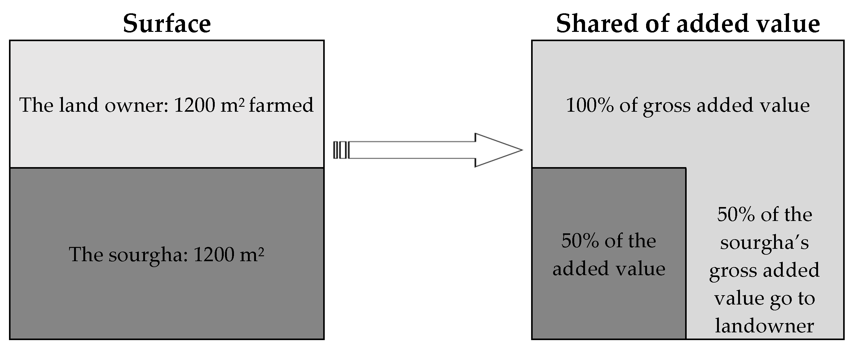
- The mbey seddo, in which the gross added value is split fifty-fifty between the employer and the sourgha. The sourghas are foreigners—Guinean, Malian, Gambian—or Senegalese from poor villages of the Dieri. These groups are generally present in the Niayes for about six months a year. In comparative agriculture, this is called “a family business farm”.
- The use of employees (with a monthly salary and not a share of added value). The head of the business hires labour on a monthly basis. In comparative agriculture, this is called “a capitalist farm”. During heavy periods, the head also calls for workers, who are paid on a daily basis, with money or in kind. The labourer often comes from a nearby village or are manual farmers who devote a quarter of their time to such employment and the rest to his family’s vegetable garden.
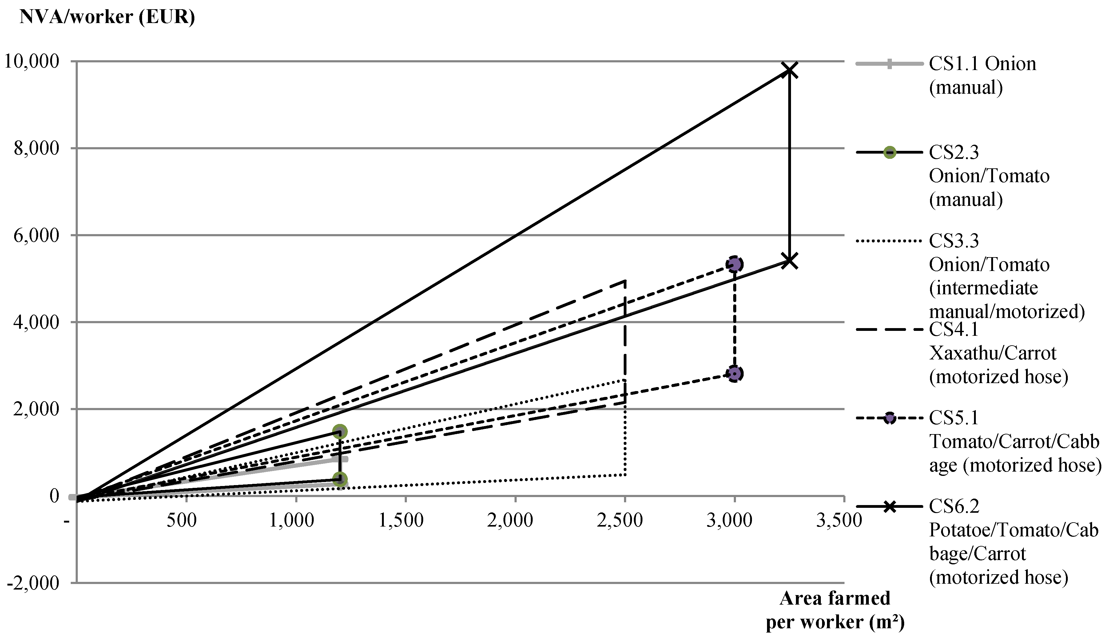
- Manual: water drawing and distribution are manual (with a bucket-pulley and a bucket, respectively);
- Combined: water drawing is motorized (motor-pump) but water is distributed manually (bucket);
- Almost entirely motorized: use of a motor-pump, then water is distributed via a network of vinyl tubing (PVC) and sprayed through a hose.
3.2.3. Land Owners’ Accumulation of Wealth
3.2.4. Motorization Allows an Acceleration of Enrichment
4. Discussion
5. Conclusions
Acknowledgments
Author Contributions
Conflicts of Interest
References
- Loloum, M. Analyse-Diagnostic de L’Agriculture de la Zone des Niayes au Nord-Ouest du Sénégal: Etude de la Zone des Niayes de la communauté Rurale de Léona, Département et Région de Louga; Mémoire de Mastère en Agriculture Comparée et Développement Agricole, AgroParisTech: Paris, France, 2010. [Google Scholar]
- Mazoyer, M.; Roudart, L. Histoire des Agricultures du Monde. Du Néolithique à la Crise Contemporaine; Seuil: Paris, France, 1997; p. 534. [Google Scholar]
- Dufumier, M. Les Projets de Développement Agricole. Manuel d’Expertise; Karthala and CTA: Paris, France; Wageningen, The Netherlands, 1996; p. 354. [Google Scholar]
- Cochet, H. Comparative Agriculture; Springer: Dordrecht, The Netherlands; Quae Editions: Versailles, France, 2015; p. 154. [Google Scholar]
- Dufumier, M. Agriculture et Paysanneries Des Tiers Mondes; Karthala: Paris, France, 2004; p. 600. [Google Scholar]
- Brossier, J. Système et système de production, note sur les concepts. In Cahiers des Sciences Humaines; ORSTOM: Paris, France, 1987; Volume 23, pp. 377–390. [Google Scholar]
- Cochet, H.; Devienne, S. Fonctionnement et performances économiques des systèmes de production agricole: Une démarche à l’échelle régionale. Cah. Agric. 2006, 15, 578–583. [Google Scholar]
- Khastalani, A.K. Études des transformations agraires dans la communauté rurale de Thieppe dans le département de Kébémer. In Mémoire d’Ingénieur Agronome de l’ENSA; Ecole Nationale des Sciences Agronomiques: Thiès, Sénégal, 2010. [Google Scholar]
- Pouye, A. Etudes des transformations agraires dans la Communauté rurale de Bandègne Wolof, dans le département de Kébémer (région de Louga). In Mémoire d’Ingénieur Agronome de l’ENSA; Ecole Nationale des Sciences Agronomiques: Thiès, Sénégal, 2010. [Google Scholar]
- Miss, F. La bande de filaos: Analyse de la gestion mise en œuvre par les groupements maraîchers des Niayes et perspectives de développement de la filière. In Mémoire Pour Obtenir le Diplôme d’ingénieur du GÉNIE Rural Des Eaux et Forêts, Spécialisation Forêt-Nature-Société; AgroParisTech-ENGREF: Montpellier, France, 2010. [Google Scholar]
- Gaye, A.T.; Lo, H.M.; Sakho-Djimbira, S.; Fall, M.S.; Ndiaye, I. Sénégal: Revue du Contexte Socioéconomique, Politique et Environnemental; IED: Dakar, Senegal, 2015; p. 87. [Google Scholar]
- Ministère de L’Environnement et de la Protection de la Nature. Rapport National Sur L’état de L’environnement Marin et Côtier; MEPN: Dakar, Senegal, 2002.
- Trochain, J. Contribution à L’étude de La Végétation du Sénégal; Larose: Paris, France, 1940; p. 434. [Google Scholar]
- Fall, M. Environnements sédimentaires quaternaires et actuels des tourbières des Niayes de la Grande Côte du Sénégal. In Thèse du 3e Cycle Géologie: Sédimentologie; Université Cheikh Anta Diop: Dakar, Senegal, 1986. [Google Scholar]
- Monciardini, C. La Sédimentation Éocène au Sénégal; Mémoire B.R.G.M: Paris, France, 1965; p. 105. [Google Scholar]
- Michel, P. Les Bassins des Fleuves Sénégal et Gambie: Etude Géomorphologique. Ph.D. Thesis, Université Louis Pasteur, Strasbourg, France, 1973. [Google Scholar]
- Noël, Y. Étude Hydrogéologie Des Calcaires Lutétiens Entre Bambey et Louga (2ème phase); BRGM: Dakar, Sénégal, 1978; p. 82. [Google Scholar]
- Claude, A. Sensibilité d’Hydrosystèmes Côtiers Particuliers Aux Variations Millénaires du Niveau Marin au Sénégal. Mémoire de Master 2 Sciences de l’Univers, Environnement, Écologie, Parcours Hydrologie-Hydrogéologie. Master’s Thesis, Université Pierre et Marie Curie, École des Mines de Paris & École Nationale du Génie Rural des Eaux et des Forêts, Saclay, France, 2007. [Google Scholar]
- Saos, J.L.; Fall, M. Sédimentologie et Variations Climatiques Dans Les Tourbières Holocènes Sénégalaises, SEMINAIRE Paléolacs et Paléoclimats en Amérique Latine et en Afrique (20 000 ans B.P.-Actuel): Résumés des Communications Présentées au Séminaire Géodynamique; ORSTOM: Bondy/Montpellier, France; Dakar, Sénégal, 29–30 January 1987. [Google Scholar]
- Lézine, A.M. Paléo-Environnements Végétaux d’Afrique Occidentale Nord-Tropicale Depuis 12 000 B.P.: Analyse Pollinique de Séries Sédimentaires Continentales (Sénégal-Mauritanie), Séminaire Paléolacs et Paléoclimats en Amérique Latine et en Afrique (20 000 ans B.P.-Actuel): Résumés des Communications Présentées au Séminaire Géodynamique; ORSTOM: Bondy/Montpellier, France; Dakar, Sénégal, 1987. [Google Scholar]
- Ministère de l’Environnement et de la Protection de la Nature. Plan D’Action National D’Adaptation Aux Changements Climatiques; MEPN: Dakar, Sénégal, 2006; p. 84.
- Pezeril, G.; Châteauneuf, J.J.; Diop, C.E. La Tourbe des Niayes au Sénégal: Genèse et Gitologie, Symposium International INQUA/ASEQUA du 21 au 28 avril 1986: Changements Globaux en Afrique; ORSTOM: Paris, France, 1986. [Google Scholar]
- Eswaran, M.; Kotwal, A. Access to Capital and Agrarian Production Organization. Econ. J. 1986, 96, 482–498. [Google Scholar] [CrossRef]
- Bélières, J.F.; Bonnal, P.; Bosc, P.M.; Losch, B.; Sourisseau, J.M. Les Agricultures Familiales du Monde: Définitions, Contributions et Politiques Publiques; AFD: Paris, France, 2013; p. 281. [Google Scholar]
- Raynal, A. Flore et Végétation des Environs de Kayar (Sénégal): De la Côte au Lac Tanma; Faculté des Sciences, Université de Dakar: Dakar, Senegal, 1963; pp. 121–231. [Google Scholar]
- Maley, J.; Vernet, R. Peuples et Evolution Climatique en Afrique Nord-Tropicale, de la Fin du Néolithique à l’aube de l’époque Moderne; Afriques: Paris, France, 2013; p. 50. [Google Scholar]
- Boulègue, J. Les Anciens Royaumes Wolof (Sénégal). Volume 1: Le grand Jolof. XIII–XVIème Siècle; Editions Façades: Paris, France, 1987; p. 208. [Google Scholar]
- Camara, M. Approche Participative Dans la Gestion Intégrée des Ressources en Eau De la Zone des Niayes (de Dakar à Saint-Louis). Master’s Thesis, Faculté des Lettres et des Sciences Humaines, Département de Géographie, Université Cheikh Anta Diop, Dakar, Sénégal, 2010. [Google Scholar]
- Thiam, E.H.I. Les Terroirs Périphériques de la Reserve Spéciale de Faune de Gueumbeul. Master’s Thesis, Université Cheikh Anta DIOP (UCAD), Dakar, Sénégal, 2004. [Google Scholar]
- Coly, B. Dynamique Des Ressources Naturelles Dans la côte Nord du Sénégal, de Dakar à Saint Louis. L’exemple de la communauté rurale de Mboro. Master’s Thesis, Université Cheikh Anta Diop, Dakar, Sénégal, 2000. [Google Scholar]
- Dione, D. Problèmes de Développement Des Activités du Secteur Primaire Dans la Banlieue De Dakar. Ph.D. Thesis, Université de Limoges, Limoges, France, 1986. [Google Scholar]
- Dieng, N.M. l’Impact du Maraichage Dans la Dégradation Des Ressources Naturelles Dans Les Niayes de la Bordure du lac Tanma. Master’s Thesis, Université Cheikh Anta Diop, Dakar, Sénégal, 2008. [Google Scholar]
- Mbengue, A.A. Analyse des Stratégies de Commercialisation de l’Oignon Local Dans Les Niayes. Master’s Thesis in Rural economy, ENSA, Thiès, Sénégal, 2007; p. 73. [Google Scholar]
- Institut Sénégalais de Recherches Agricoles. Exploitations Horticoles Avec Irrigation Goutte-à-Goutte Dans le Bassin Arachidier; Institut Sénégalais de Recherches Agricoles: Dakar, Sénégal, 2013; p. 120. [Google Scholar]
- Groupe de Travail Désertification. Agroécologie, une Transition Vers des Modes de Vie et de Développement Viables Paroles d’Acteurs; Groupe de Travail Désertification: Montpellier, France, 2013; p. 60. [Google Scholar]


| Zones | Ndioukis (B) | Semi-Fixed Dunes (C) | Peaty Niayes (D and E) | High Basins of Continental Dunes (F) | Dieri | |
|---|---|---|---|---|---|---|
| Pastoral Transition Area and Dieri Area (G) | Rainy Cultivating Area (H) | |||||
| Altitude (≈level difference between thalweg bottom and dune top) | Five to ten meters (m) | 10–20 m | 10–15 m (more important level difference towards Fass Boye with about 20 m summits) | 15–25 m | 25 to 30 m | 30 to 45 m |
| Access to water | Water ground is in average two to five meters. | Relatively easy access (water ground is at seven to fifteen meters) | Water is almost flushing in the basin bottom. | Difficult access (15–20 m) | Very deep water ground (>25 m), for annual plants, available water is rain). | |
| Soils | Sandy and very poor in organic material. | Sandy (dior) in height and sandy and muddy or deck-dior in basin bottom. | Clayey and peaty (xour) in basin bottom, clayey and sandy in mid-slope (ban) | Sandy (Dior) | Sandy dior type, with very slight textural variation on the top of dunes (weak textural stability) in slope bottom (with few silts accumulated by colluviation). | |
| Spontaneous and woody vegetation | Steppe, with scarce Casuarina equisetifolia, due to close presence of filao trees strip. | Various acacias and combretacea. Cactacea and euphorbiacea disseminated by humans. | Guinean-type vegetation with palm trees (Elaeis guineensis and Cocos nucifera) With aquaphyle plants (Nymphaea lotus, Phragmites vulgaris, Typha australis) | Various acacias and combretacea. Cactacea and euphorbiacea disseminated by humans. | Shrubby savanna with Detarium senegalensis, Cassia sieberiana, Celtis integrifolia, Prosopis africana and Securidaca longipediculata | Wooded parks with Acacia albida and Adansonia digitata. |
| Entrepreneurial Agricultures |  | Family Agricultures | |
|---|---|---|---|
| Types of production units | Enterprise farm | Family business farm | Family farm |
| Labour | Specialize in supervision of hired labour | Work on farm and supervise hired labour | Family labour; no permanent hired labour |
| Item | Qty | Unit | Unit Price (FCFA) | Expense (FCFA) | Frequency | Ratio | Yearly Expenses (FCFA) |
|---|---|---|---|---|---|---|---|
| Food | |||||||
| Rice | 3 | kg/day | 300 | 328,500 | every day | 1.00 | 328,500 |
| Millet | 3.7 | kg/day | 150 | 202,575 | every day | 1.00 | 202,575 |
| Fresh mill | 3.7 | kg/day | 30 | 40,515 | every day | 1.00 | 40,515 |
| Peanut paste | 0.4 | kg/day | 240 | 23,360 | 2 days over 3 | 1.00 | 23,360 |
| Crushed peanut | 0.4 | kg/day | 480 | 23,360 | 1 day over 3 | 1.00 | 23,360 |
| Charge in water | 1 | Daily rate | 150 | 54,750 | every day | 1.00 | 54,750 |
| Condiments | 1 | Daily rate | 400 | 146,000 | every day | 1.00 | 146,000 |
| Total | 819,060 | ||||||
| Clothes | |||||||
| Uniform for children | 9 | set | 2500 | 22,500 | 3 times per year (start of academic year, tabaski and other) | 1.00 | 22,500 |
| Sandals for women | 6 | pair | 750 | 4500 | 2 times a year | 1.00 | 4500 |
| Uniforms for women | 16 | Set of 3 pagnes | 4000 | 64,000 | 3 times | 1.00 | 64,000 |
| Sandals for men | 8 | pair | 750 | 6000 | 2 times a year | 1.00 | 6000 |
| Uniforms for men | 12 | uniform | 4000 | 48,000 | 2 times | 1.00 | 48,000 |
| Sandals | 8 | pair | 750 | 6000 | 2 times a year | 1.00 | 6000 |
| Total | 151,000 | ||||||
| Consumable | |||||||
| Soap | 12 | month | 1500 | 18,000 | pm | 1.00 | 18,000 |
| Battery or oil | 1 | Monthly rate | 1500 | 1500 | pm | 1.00 | 1500 |
| Health care | 12 | month | 3000 | 36,000 | pm | 1.00 | 36,000 |
| Total | 55,500 | ||||||
| Utensils | |||||||
| Torch | 8 | Unit | 1000 | 8000 | 1 year over 4 | 0.25 | 2000 |
| Cooking pot | 4 | Unit | 4000 | 16,000 | 1 year over 2 | 0.50 | 8000 |
| Basin | 2 | Unit | 3000 | 6000 | 1 year over 4 | 0.25 | 1500 |
| Bucket | 2 | Unit | 3000 | 6000 | 1 year over 4 | 0.25 | 1500 |
| Spoon | 4 | Unit | 500 | 2000 | 1 year over 5 | 0.20 | 400 |
| Cup | 10 | Unit | 300 | 3000 | 1 year over 5 | 0.20 | 600 |
| Tray | 4 | Unit | 2000 | 8000 | 1 year over 5 | 0.20 | 1600 |
| Plate | 10 | Unit | 300 | 3000 | 1 year over 5 | 0.20 | 600 |
| Mortar | 2 | Unit | 2500 | 5000 | 1 year over 5 | 0.20 | 1000 |
| Pestle | 2 | Unit | 250 | 500 | 1 year over 5 | 0.20 | 100 |
| Total | 17,300 | ||||||
| Survival threshold | 1,042,860 (≈1,590 €) | ||||||
| Per working person | 148,980 (≈227 €) |
| Main Types Based on Social Organization of the Farm | Sub-Types Based on Irrigation Capacities of the Farm | Basin Types | Origins/Social Trajectories of the Farmers |
|---|---|---|---|
| PS1: Familial | PS1.1: Familial Manual | B | Recent migrants in zone B, coming in the 1980’s–1990’s from zone H, with no other means but their labour force. Fulani shepherds starting agriculture (treasury brought by cattle selling) |
| PS2: Familial with employees | PS2.1: Employer Manual | B, C | Idem, but with some amount as economy brought from the Dieri. Thanks to success in livestock farming, they were gradually able to employ sourghas. |
| PS3: Capitalist | PS3.1: Capitalist manual | B, C, D | Bana-bana traders from Dieri knowing the Niayes from their work. |
| PS1: Familial | PS1.2: Familial semi-motorized (pumps and basins) | C, F | Recent migrants with consistent means. Fulani shepherds from zones C, F and B, with few cattle in the beginning. |
| PS2: Familial with employees | PS2.2: Employer semi-motorized (motor-pumps and basins) | C, D | Fulani shepherds from C, F and B zones, with access to larger surfaces and integration agriculture-breeding. |
| PS1: Familial | PS1.3: Familial motorized (hoses, drop-by-drop) | D, E | Young people from large families. Recent comers, former employees in cities or traders having invested little by little in the area through harvesting campaigns. |
| PS2: Familial with employees | PS2.3: Employer motorized (hoses, drop-by-drop) | D, E | Descendants of wealthy families; marabout notables; bana bana traders; former employees in cities (early retired or in reorientation, former immigrant). Systems maximizing peat bog valuing. |
| PS3: Capitalist | PS3.3: Capitalist motorized (hoses, drop-by-drop) | D, E, F | Wealthy bana bana traders; marabout notables or their relatives. |
| Strictly Manual | Manual + Basins | Motor-Pumps + Basins | Motor-Pumps + Hoses | Drop-by-Drop | |
|---|---|---|---|---|---|
| Volume of water (l/m²/j) | 9 | 9 | 9 | 7 | 4 |
| Maximal watered surface Smax/working person/campaign | 800 m²/working person (cabbage) to 1200 m²/working person (onion) (1 ha p. 10 working persons) | 1200–1500 m² (1 ha p. 8 working persons) | 2000–2500 m²/working person | 2 ha p. 2 working person + 2 trainees (sometimes 4 working persons + 4 trainees), so 5000 m²/working person (sometimes 2500) | 1 ha p. 1 working person, even more |
| Cultivation ability ratio (basis1 = Smax in manual) | 1 | 1.2–1.5 | 2–2.5 (+40% of basins) | 3.5 | 10 |
| Number of campaigns maximum/year/working person | 2 | 2 | 2 | 3–4 | 2–3 |
| Investment (annual depreciation per ha) | 230 € | 380 € | 300 € | 160 € | 4000 € |
| Plot of 1200 m2 | GAV (€) | GAV Sourgha (€) | GAV Employer (€) | Workload (Man Days) | Labour Productivity GAV/md (before Sharing) | Income/md Sourgha | Income/md Employer and Family | |||
|---|---|---|---|---|---|---|---|---|---|---|
| Total | Employee (Sourgha) | Employer | Punctual Labourers | |||||||
| Low yields | 301 | 151 | 151 | 183 | 138 | 26 | 20 | 1.6 € | 1.1 € | 6 € |
| Average yields | 684 | 342 | 342 | 196 | 138 | 32 | 27 | 3.5 € | 2.5 € | 11 € |
| High yields | 875 € | 438 | 438 | 203 | 138 | 35 | 31 | 4.3 € | 3.2 € | 13 € |
| Manual Production System (Number of Farms Surveyed) | ||||||||||||
| Family-Type Farms with Manual Equipment SP1.1 (13) | Family Business/Manual Equipment SP2.1 (37) | Capitalist-Type Farms with Manual Equipment SP3.1 (7) | ||||||||||
| Av. | Max. | Min. | Av. | Max. | Min. | Av. | Max. | Min. | ||||
| Number of family members | 8 | 17 | 2 | 8 | 25 | 2 | 2 | 3 | 2 | |||
| Number of family workers | 5 | 12 | 1 | 5 | 13 | 1 | 1 | 2 | 1 | |||
| Number of employees or sharecropper | - | - | - | 4 | 10 | 1 | 9 | 16 | 5 | |||
| Arable land (m2/family worker) | 733 | 4000 | 129 | 2329 | 9000 | 208 | 5814 | 8900 | 3500 | |||
| Total cultivated area (m2/family worker) | 440 | 750 | 129 | 1140 | 4186 | 169 | 4750 | 8300 | 3000 | |||
| Livestock (Tropical Livestock Unit/ha cultivated) | 25 | 125 | - | 16 | 146 | - | 6 | 13 | - | |||
| Net annual income (EUR/family worker) | ||||||||||||
| Average | 397 | 620 | 2091 | |||||||||
| Maximum | 751 | 3025 | 3653 | |||||||||
| Minimum | 116 | 51 | 1079 | |||||||||
| Intermediate and Fully Motorized Irrigation Systems (Number of Farms Surveyed) | ||||||||||||
| Family-Type Farms/Intermediate Motorizationsp1.2 (2) | Family Business Intermediate Motorization SP2.2 (6) | Family-Type Farms with Machines SP1.3 (3) | Capitalist-Type Farms with Machines SP3.3 (11) | |||||||||
| Av. | Max. | Min. | Av. | Max. | Min. | Av. | Max. | Min. | Av. | Max. | Min. | |
| Number of family members | 15 | 19 | 11 | 10 | 17 | 3 | 31 | 79 | 6 | 12 | 23 | 5 |
| Number of family workers | 10 | 12 | 7 | 7 | 11 | 2 | 20 | 51 | 5 | 8 | 13 | 5 |
| Number of employees or sharecropper | 4 | 8 | - | 5 | 11 | 1 | 1 | 3 | - | 6 | 16 | 2 |
| Arable land (m2/family worker) | 1627 | 2254 | 1000 | 1313 | 2250 | 500 | 5296 | 9804 | 2970 | 3158 | 8475 | 777 |
| Total cultivated area (m2/family worker) | 1484 | 2254 | 714 | 1118 | 2000 | 500 | 2152 | 3113 | 1431 | 2358 | 5556 | 777 |
| Livestock (Tropical Livestock Unit/ha cultivated) | 1 | 2 | 1 | 2 | 6 | - | 5 | 14 | - | 10 | 39 | 1 |
| Net annual income (EUR/family worker) | ||||||||||||
| Average | 902 | 504 | 1913 | 1858 | ||||||||
| Maximum | 1304 | 640 | 2892 | 4248 | ||||||||
| Minimum | 499 | 353 | 996 | 393 | ||||||||
© 2017 by the authors. Licensee MDPI, Basel, Switzerland. This article is an open access article distributed under the terms and conditions of the Creative Commons Attribution (CC BY) license (http://creativecommons.org/licenses/by/4.0/).
Share and Cite
Fare, Y.; Dufumier, M.; Loloum, M.; Miss, F.; Pouye, A.; Khastalani, A.; Fall, A. Analysis and Diagnosis of the Agrarian System in the Niayes Region, Northwest Senegal (West Africa). Agriculture 2017, 7, 59. https://doi.org/10.3390/agriculture7070059
Fare Y, Dufumier M, Loloum M, Miss F, Pouye A, Khastalani A, Fall A. Analysis and Diagnosis of the Agrarian System in the Niayes Region, Northwest Senegal (West Africa). Agriculture. 2017; 7(7):59. https://doi.org/10.3390/agriculture7070059
Chicago/Turabian StyleFare, Yohann, Marc Dufumier, Myriam Loloum, Fanny Miss, Alassane Pouye, Ahmat Khastalani, and Adama Fall. 2017. "Analysis and Diagnosis of the Agrarian System in the Niayes Region, Northwest Senegal (West Africa)" Agriculture 7, no. 7: 59. https://doi.org/10.3390/agriculture7070059