1. Introduction
In the first decade of the 21st century, migratory movement from the countryside to the city has been prevalent, especially in recent years, due to the economic crisis. This migratory pressure is more noticeable in large cities within Europe, such as the city of Madrid (Spain). To provide urban services and housing to meet population demand, it is necessary to occupy terrains characterized as problematic that were previously discarded due to their high content of potentially expansive clays. In general, this type of deposit is found in regions with arid and semi-arid climates, such as the Mediterranean strip, South Africa, southern North America, northern South America, etc. It is estimated that 28% of the existing geological formations contain clays with expansive capacity forming the subsoil of large cities such as London, Madrid, Cape Town, etc. A common solution would be to remove the clays to landfill, or to use loans of other materials with better geotechnical characteristics, which would require great economic resources and potentially cause environmental problems.
The growing demand for urban land in the city of Madrid in recent years has made it necessary to use geotechnically problematic areas which have historically been avoided [
1,
2,
3]. Without any doubt, the lands in the southeast of Madrid are the most relevant in this aspect, not only because they are the new and future areas of expansion of the capital city of Spain, but also because they pose a barrier to the social and economic growth of the city due to their clayey and potentially expansive nature [
4].
The construction of infrastructure in this area: roads, railway lines, and macro-housing developments (meaning urban actions with an occupation of 7,000,000 m
2 or more), has made it necessary to improve a series of design and construction procedures that take into consideration the presence of volumetrically unstable clay in an effort to reuse excavated material to minimize the environmental impact of creating new landfills and borrow pits [
5,
6].
There are no inert landfill areas in the area of new urban developments in the southeast of Madrid and its contiguous towns. This, in addition to the fact that the borrow pits of traditionally used materials are far from the area of action, makes the expansion of the urban network economically unfeasible. In order to overcome this problem, construction methods and procedures have been developed to make use of materials which, in accordance with the General Technical Specifications for Road and Bridge Work (PG-3) of the Spanish Ministry of Public Works, would be defined as marginal materials.
This work aims to propose a constructive procedure that allows the reuse and implementation of these clay materials, improving their geotechnical properties. The proposed procedure is applied to a case study, the new urban extensions of the city of Madrid. The results show that it is possible to apply the proposed methodology in a generalized manner in the construction sector. Additionally, when using existing materials, the environmental impact associated with the expansion of these areas is drastically reduced, with fewer transport costs and less collection of materials in landfills. In parallel, the need for consumption of raw materials associated with this activity decreases.
2. Methodology
The geology and geotechnics of southeast Madrid, where volumetrically unstable clayey deposits have been described, requires techniques that allow for the use of this type of material; always with an adequate analysis of the problems associated with the particular linear infrastructure work or with the construction of buildings. This article is structured as follows (
Figure 1). Firstly, the geological environment is described, establishing a sedimentary setting and a detailed mineralogy analysis of the tertiary clay. Secondly, a geotechnical characterization is done, based on a quantitative description of the basic properties (soil quality indicators), which, along with grain size and mineralogy composition, will determine the geotechnical classification. The information obtained is synthetized to reflect the most significant values for each quantified characteristic. Then, a detailed description of the methodology developed is offered. Finally, a methodology is established in order to contribute to the improvement and development of new techniques that have been proven valid for this type of land, and, the future fields of application are described.
In order to understand the construction procedures to be used in new areas of development, the geological characteristics of this sector of Madrid’s river basin must be established, focusing on the study of the clayey and plastic transition deposits as well as on the processes originating in them.
Following this line of reasoning, different deposition systems will be reconstructed taking into account the basin fill, and, along with this, the syngenetic conditions that will mark the final distribution of the deposits. In general, the basin fill enters in a model of mixed continental endorheic basin deposition, where the deposits outcrop to the inside, creating the classical facies distribution outline with edge, intermediate, and central areas with various changes in facies [
7,
8].
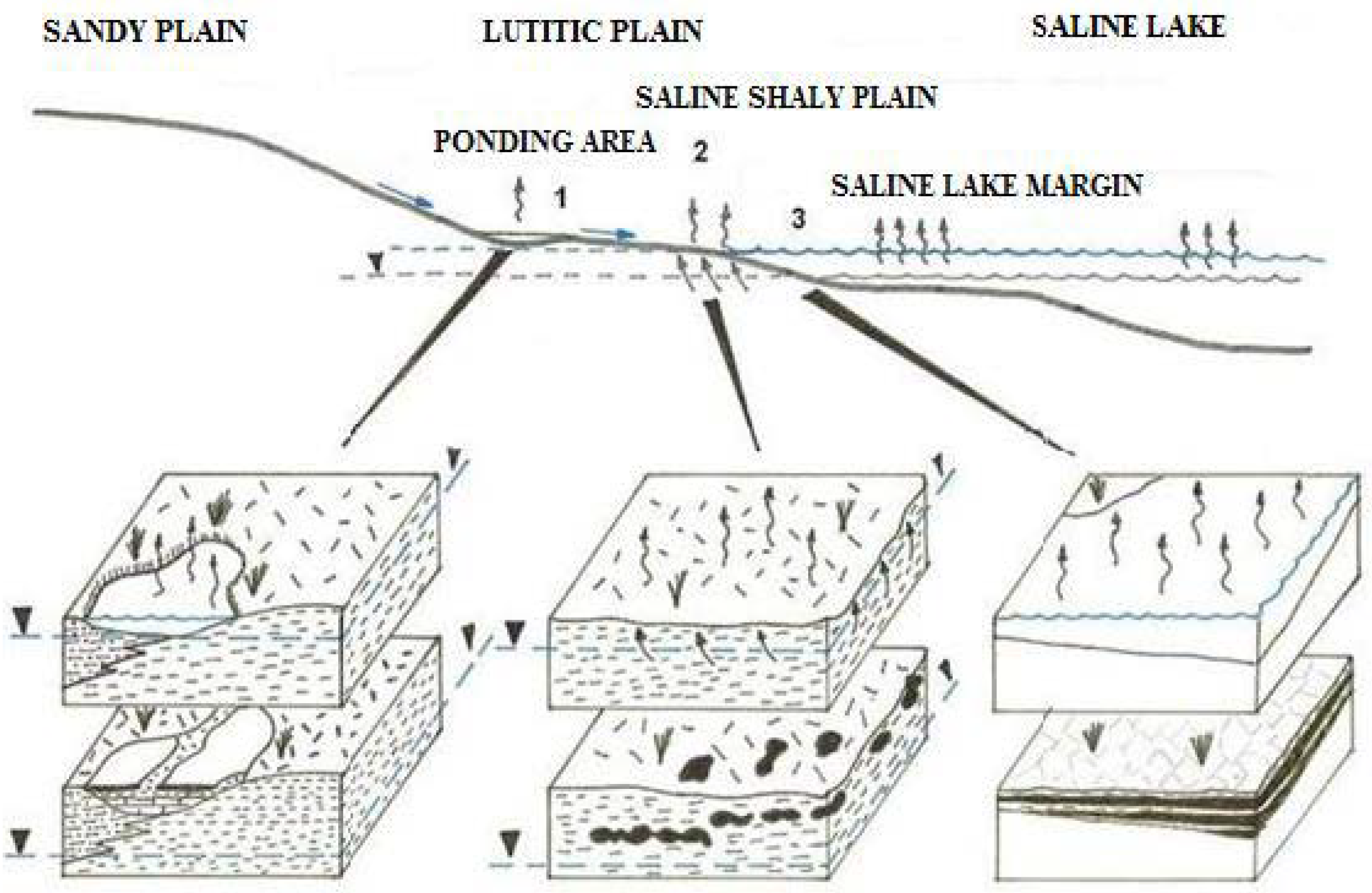
The larger grain size materials that are deposited on the edge of the river basin are predominantly granitic, this gives rise to sandy deposits and smaller size detritus which are transported a longer distance to where they will logically be distributed according to the energy in the environment and the size of the particle (
Figure 2). There is no energy in the middle of the basin, and water stagnates to flood a large area which gives rise to a lacustrine environment where chemical precipitation is abundant.
In principle, this very simple and classical outline allows for the establishment of spatial distribution of the different geological formations, which, due to their syngeneic characteristics, occupy very specific positions in the river basin [
9]. As will be seen, these geological formations will have key geotechnical repercussions. It also enables us to be able to differentiate, thanks to the existing sedimentary discontinuities, three major deposition sequences: an upper, intermediate, and lower deposition sequence; the last two are present in the Southeast of Madrid.
The lower deposition sequence is represented by predominantly evaporite deposits (gypsum) where detritus materials of a predominantly clayey nature interdigitate to a greater or lesser extent. The following can be differentiated, massive gypsum, folded gypsum, and clay with gypsum along with other units of lower entity. Regarding the sediment, it corresponds to native syngenesis which is typical of the central part of the river basin, and the deposition environment corresponds to the lacustrine areas.
The intermediate deposition sequence found on this part largely consists of evaporite deposits (gypsum). It is represented by a series of predominantly clay sediments that are lithologically quite heterogeneous and are comprised of brownish-green clay with whitish marl and marl-dolomite, beige sepiolite clay, brown smectite clay, and folds of purplish opaline silica.
These sediments are articulated in a varied range of sequences, a reflection of the great variety of deposition environments, separated from the underlying gypsum deposits by a paleokarstick surface [
10]. The thickness of the clay deposits once reached several dozens of meters above the current land surface, although later, erosion processes created the current thickness of these sediments between fifteen and forty meters. It is over these deposits where the esplanade works and the construction of primary infrastructures of the urban development are planned.
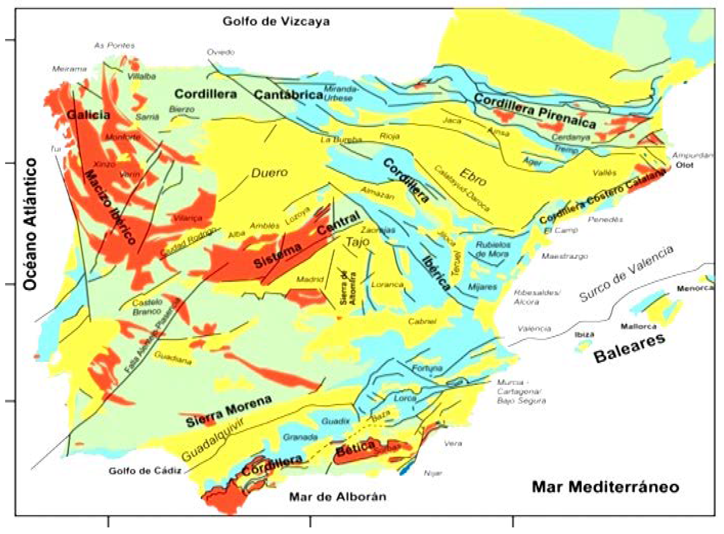
These marginal lands are very frequent within the tertiary deposits of continental origin, as in the tertiary basins of the Iberian Peninsula and Latin America. Such areas are highlighted in yellow in
Figure 3.
Mineralogical Characteristics
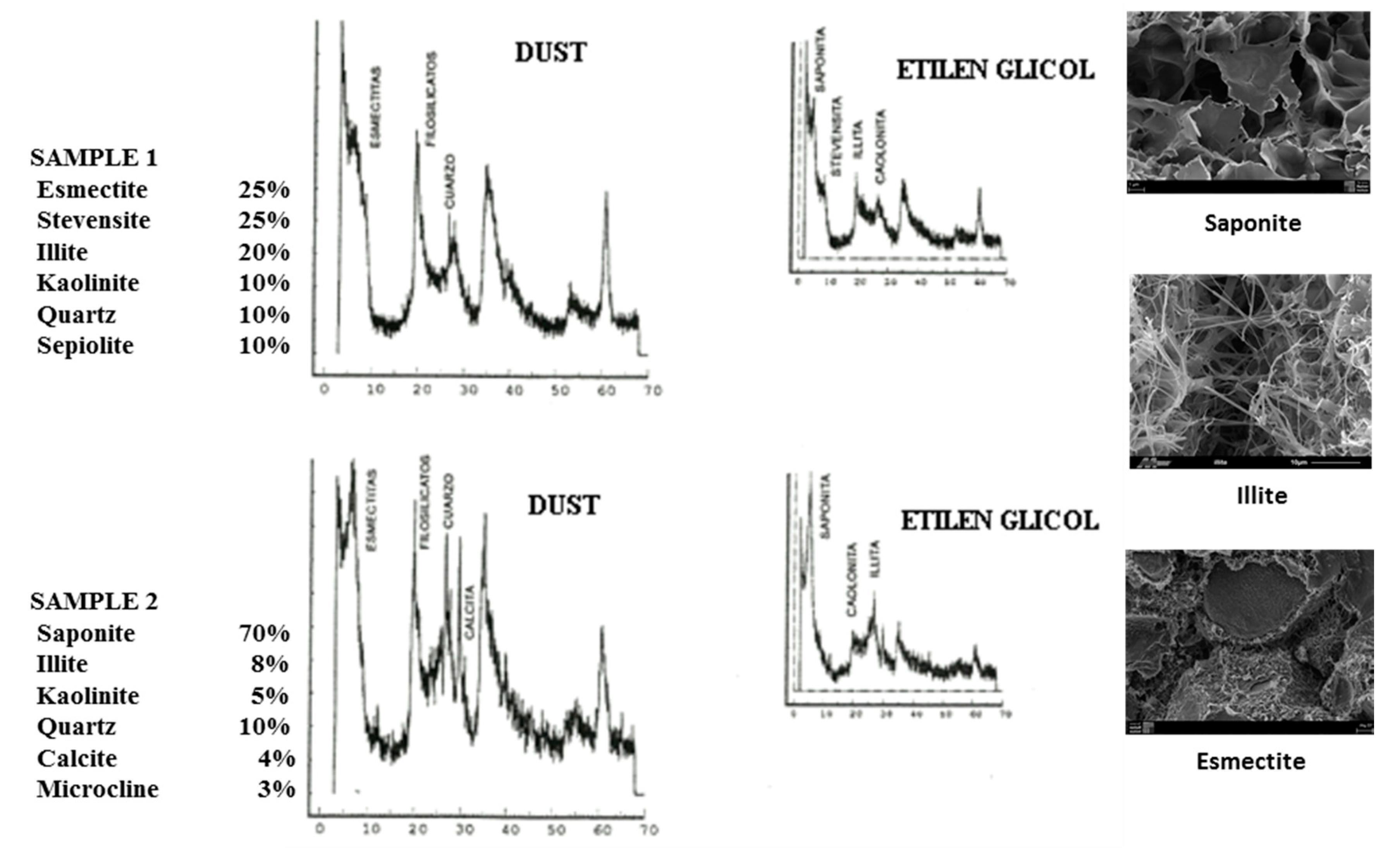
Dust diffractograms were performed on the samples representing these types of clayey deposits in order to determine their mineralogical composition. To do so, the samples were dried at 55 °C for at least 24 h. They were later quartered to obtain homogenous samples for the test.
Given the importance of characterizing the clay minerals from a mineralogical perspective, oriented aggregation was done with ethylene glycol at 550 °C. The aim was to use these techniques to be able to identify and quantify mineral phases with a maximum margin of error of 5%.
As seen in
Figure 4, most of the minerals are smectites. This is a group of clay minerals with a laminar T–O–T (2:1) structure, in other words, an octahedral layer between two tetrahedral layers tightly joined together by means of a covalent connection. The main characteristic is that the structural unit is not electrically neutral, mainly because of the isomorphic substitutions of cations with others of different valences.
In fact, the presence of this laminary layer explains the intrusion of fluids or molecules in the interlaminar spacing which separate the laminae producing swelling or retraction; these fluids are lost during dry periods. The most common mineral found in the smectite group is saponite, and, to a lesser extent, stevensite. Their main characteristics are low density, situation below the Casagrande A line, and significant volumetric change (expansion and retraction).
3. Geotechnical Characterization
3.1. Characteristics of Identification
From a geotechnical perspective, clayey deposits are characterized by the percentage of material that passes through a UNE 0.080 (No. 200 ASTM Series) sieve, which is often very close to 100% [
11]. In order to emphasize this characteristic,
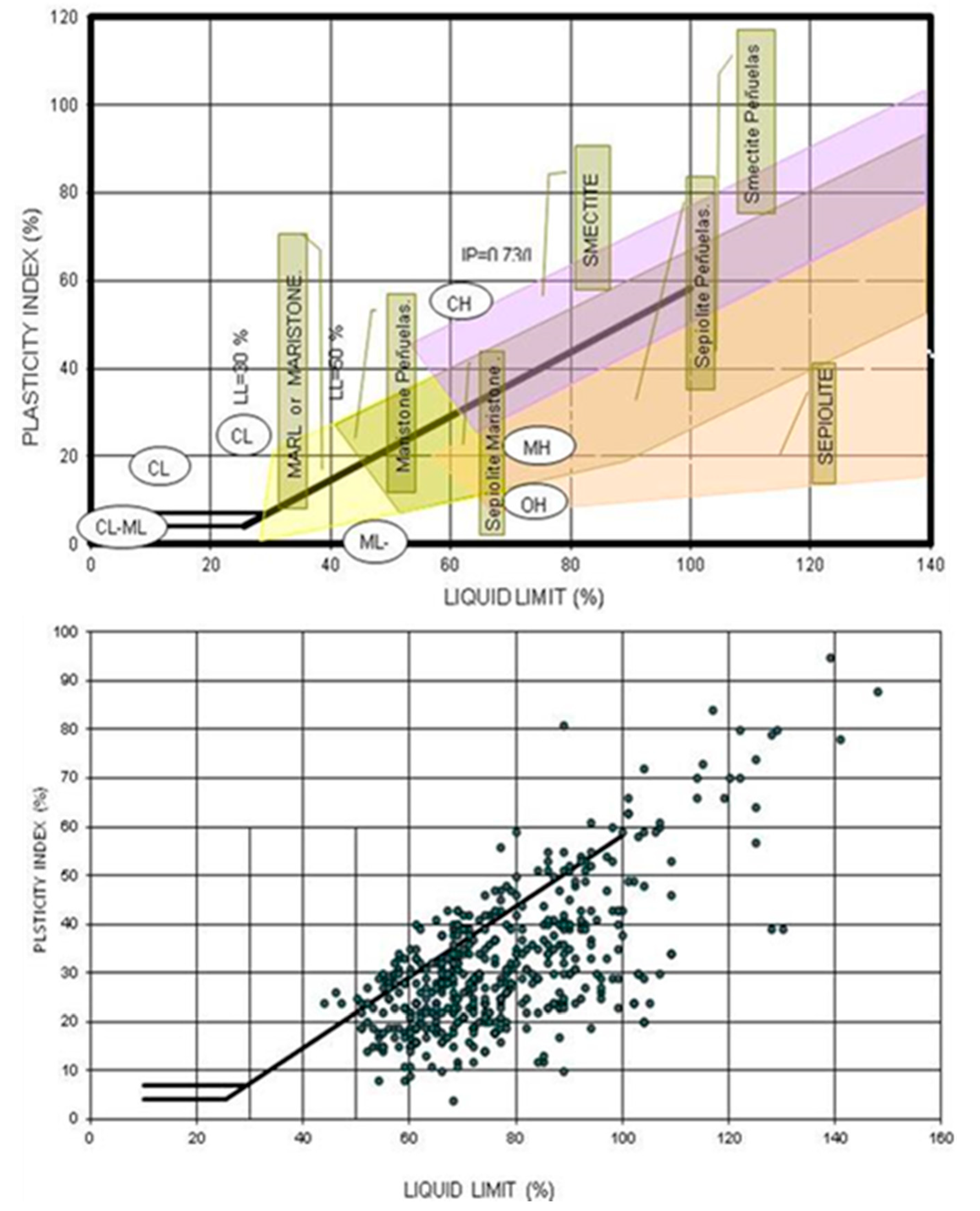
Table 1 shows the percentage of the fine material that passes through a No. 0.080 UNE sieve (200 ASTM). It is a highly plastic soil perfectly concordant with the mineralogy due to a high content of smectite and characteristic grain sizes. The liquid limit shows values that vary between 46 and 104, with occasional values above 120, as can be seen in
Figure 5.
Another noteworthy aspect is the distribution and positioning of the resulting point cloud around the “A” line. This aspect will provide information as far as the mineralogical composition of the particles comprising this formation [
12]. In fact, most of the representative samples (around 85%) are below the threshold “A” line that divides the graph into two main domains: the silt domain situated below the “A” line and the clay domain (above the “A” line). According to this first classification, most of the points represented are in the silt domain, occupying an area defined as “MH”, which, as per the Unified Soil Classification System (USCS), corresponds to high plasticity silt. According to the AASHTO classification, they correspond to group A-7-5 and A-7-6 materials with group indices that vary between 12 and 20.
Therefore, and irrespective of the classification system used, these types of materials can be classified as marginal (as per the Spanish Ministry of Public Works Technical Specifications), meaning a very detailed feasibility study is required for them to be used to build embankments.
3.2. Characteristics of State
The characteristics of state make it possible to establish some physical properties which are intrinsic as far as the material studied as well as dependent on the subsoil conditions. They account for one of the most important factors that will determine the behavior of some of the determinant geotechnical parameters of these types of clay deposits.
One of the most representative characteristics of these types of deposits is the density. They are materials with a very low density and a range of values of between 0.76 and 1.68 g/cm3 with an average value of 1.24 g/cm3, due to the presence of sepiolite and saponite materials. The natural humidity of all the analyzed samples shows values ranging between 18.4% and 70.5%, with an average value of 34.1%. This dispersion of values is due to the mineralogical variations in these types of clayey deposits. Also noteworthy is how the lowest values coincide with samples with high natural humidity content (around 58%) and a high liquid content limits conditions that expose a mineralogical composition that is predominantly sepiolite and saponite.
3.3. Swelling Tests: Expansion
The aim of the expansivity test is a qualitative and quantitative characterization of the change in volume in these clayey deposits when faced with variations in humidity. The tests were performed to objectively produce the classification and quantification ranges for the volumetric variations observed, and are based on direct laboratory testing methods. To this end, and in order to determine the potential expansivity, the three most common types of tests were used:
The free swelling tests were done following the specifications of Standard UNE 1003-601. The procedure followed the lateral confinement of the remoulded and compacted sample which is subjected to a pressure of 1 kp/cm2 and then flooded.
The proportion of deformation in relation to the original height of the sample, expressed as a percentage, defines the free swelling. The obtained results, which are reflected in
Table 2, show a wide range of values of between 0.2% and 4.45%, with very sporadic values of 10% and even 20%.
Swelling pressure tests were performed in order to obtain the pressure caused by the expansiveness. The sample (unaltered, in this case) is subjected to a pre-established load. Later it is flooded and the load is gradually increased to the extent necessary to keep the sample at a constant volume. The pressure exerted to reach the balance is defined as swelling pressure. The obtained results are shown in
Table 3.
Finally Lambe swelling tests were performed. This test, which is performed as per Standard UNE 103600, is based on Lambe’s expansion apparatus, and consists of an expansive soil identification and quantification test which results in an “expansion index”. The advantages include simplicity and speed. The obtained results are shown in
Table 4.
3.4. Bearing and Stiffness Tests
These tests were done to determine the use of these plastic and potentially expansive clayey deposits. The tests performed were as follows:
The range of variation in the results obtained determines the rating of the natural esplanade materials. The standard Proctor compactness test was done following Standard UNE 103500/94 specifications and the values obtained for maximum density and optimal humidity are shown in
Table 5.
Several tests were done to determine the CBR index, as per Standard UNE 103502/95, with the compaction energy from the standard Proctor test on the altered samples mentioned above. The importance of this test lies in determining the behavior of the tertiary clayey deposits, once they are used in construction, by measuring the resistance of the land against the penetration of a piston on three test tubes with soil compacted at different energies with Proctor humidity, after having subjected them to immersion for a certain period of time under the action of a specific overload. After this period of immersion, the difference in volume in the test tubes was measured. The results obtained are rather homogenous, meaning the index ranges between 3 and 10, with swelling between 0.0 and 0.6; the most significant values are summarized in
Table 6 below.
3.5. Summary of the Information Obtained
Table 7 quantifies all of the geotechnical properties of the clayey deposits in this sector of Madrid’s river basin. The quantification of the main characteristics and properties are concordant with the contributions of other authors on these types of deposits when studying the different infrastructures of the city of Madrid.
4. Works Execution and Control
The only urban development action completed to date of the 14 planned was the Ensanche de Vallecas. With this urban development action, the earth moving work was conditioned on the ridged topography of the area, where the corresponding clearing and embankments were completed in order to create a flat surface.
Under these conditions, planned land movement measurements account for a total dismantling volume of 12.5 million cubic meters, of which 9 million cubic meters will be used in the formation of embankments, roads, and parcels destined for building. The remaining 3.5 million cubic meters will be used for the formation of embankments in green areas, where the geotechnical condition is lower.
The material used for the construction of the embankments was potentially expansive plastic clay obtained from the excavation performed when clearing.
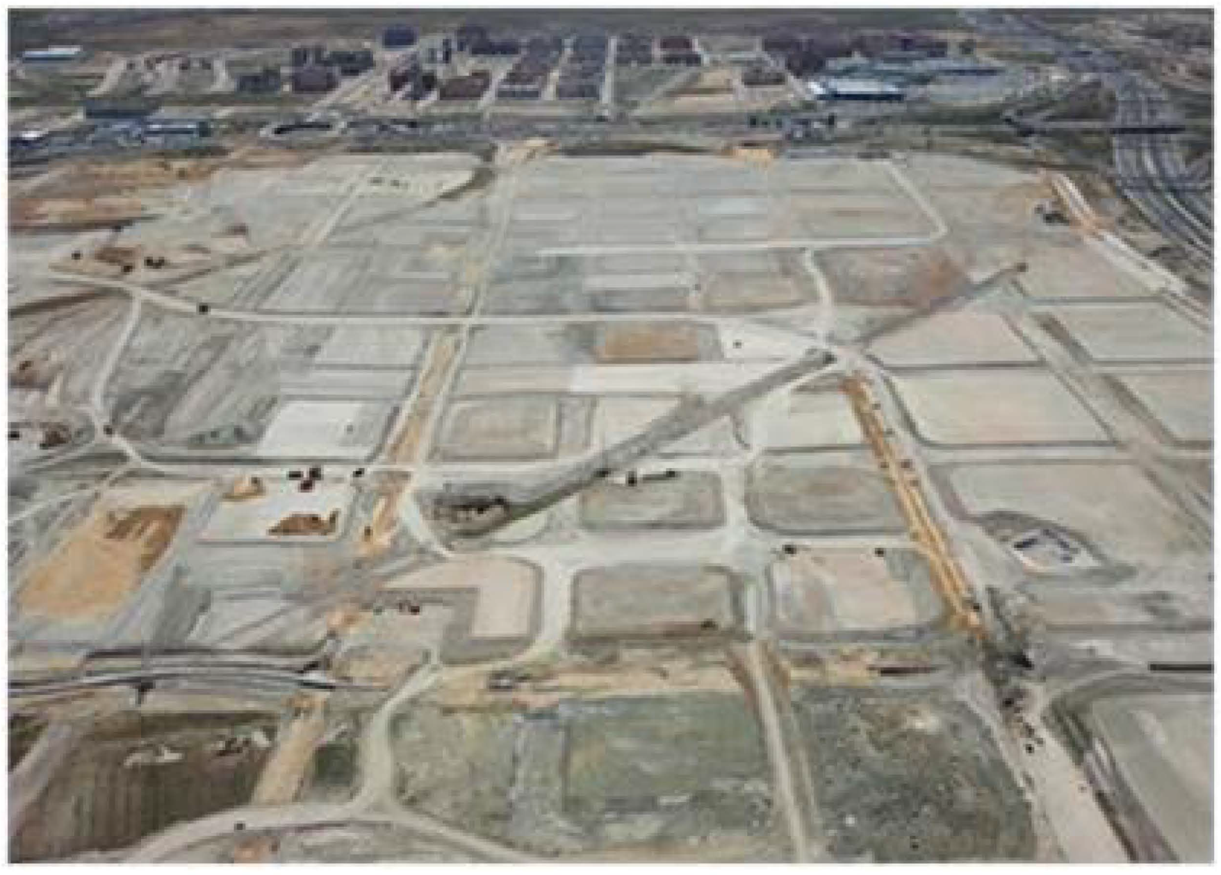
Figure 6 shows an aerial view of the earth movements associated with the construction of the vertebral vials of a macro urbanization in voluminously unstable clay soils. As previously mentioned, and from a strict perspective, this type of clay is not the right soil to build the bodies of the road embankments.
On the other hand, rejecting its use or re-use would involve removing it to a landfill as well as the use of borrow pits with other materials of better geotechnical characteristics. These borrow pits are located in areas that are far away, given the geology of the environment, which causes the associated environmental impacts, as well as the unquestionably higher financial costs involved in the operation.
The fillings were completed with lime stabilization using the same clay that was used for the embankments to stabilize the soil. The mix was comprised of 6% lime in dry soil. Lower dosages were not adequate because of the plasticity and swelling pressure, which initially decreased but began to increase after long curing times at high pH and room temperature [
12].
In the treatment of these soils, quicklime, with a maximum of 5% calcium oxide, was used to guarantee an improvement in the geotechnical characteristics of the treated soils. Thus, as an empirical rule, approximately 3 percent of quicklime is equivalent to 5 percent of hydrated lime, when conditions allow complete hydration of quicklime with sufficient moisture.
It is also widely accepted that the stabilization is less effective with concentrations lower than 6%, since the mechanical properties of treated clays need improvement in the short and long term. Higher concentrations, however, could be harmful since the lime can act as a pH buffer, resulting in a premature pH reduction, therefore limiting the long-term mineralogical changes in the clay minerals subjected to treatment with lime.
Execution Procedure. Test Stretches
With the construction of earth moving work it is fundamental to verify the behavior of the materials on a real scale as well as the adequacy of the machinery used and the work control methodology [
12,
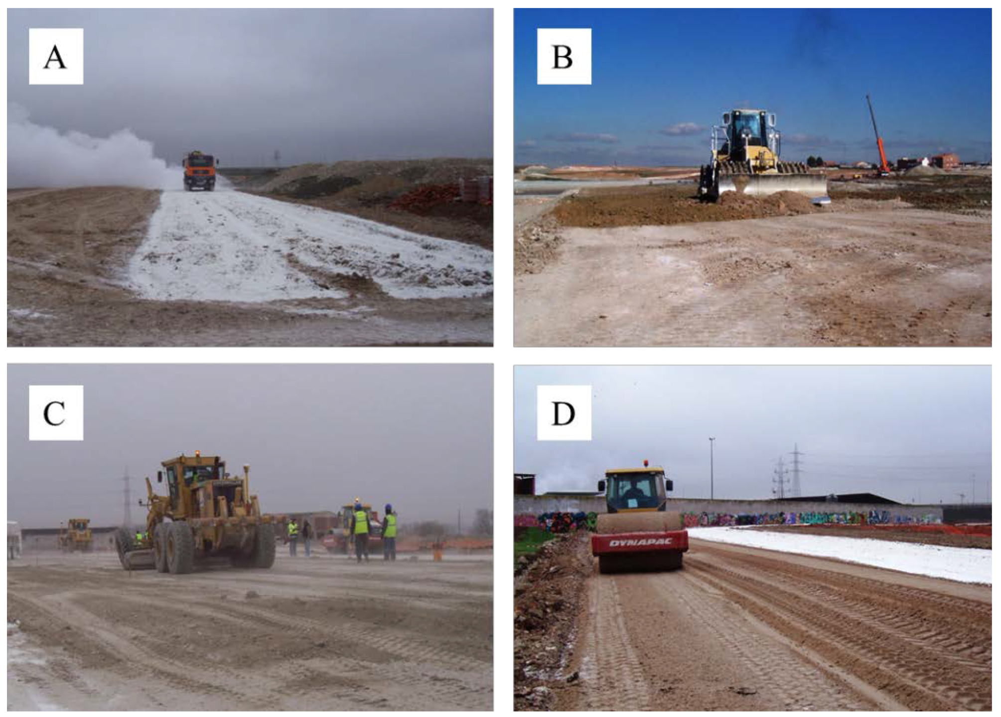
13]. A test stretch was completed for this purpose; the system for controlling the embankments consisted of the following (
Figure 7A–D depicts the described stages).
The materials were mixed using a 25 ton static weight pad foot drum (Caterpillar 825b model), with a minimum of four passes. At the same time, the materials were wetted. Once this first compacting process was complete, the layer was profiled with a bulldozer in order to create an adequately finished layer, which will ensure water from any precipitation is evacuated as quickly as possible.
The thickness of each layer was 0.25 m, and comprised of soil obtained from the clearing, which, as mentioned above, was clay of varied mineralogical composition (montmorilonite, saponite, stevensite, sepiolite, etc.). No logical grade could be deduced as far as the composition because of the spatial distribution. For this reason, and due to the difficulties of accurately determining the mineralogical composition of the materials, as well as the conditions for implementation, the choice was made to perform an exhaustive control of the embankment execution procedure, from the preparation of the foundation ground to the exploitation of the clearings and the compacting.
The quality control was performed following the standard procedure and was supplemented with density and humidity tests using nuclear methods that were duly calibrated and contrasted with sand and stove drying methods. The obtained results showed average values of 99% regarding the respective used pattern densities and average humidity, corresponding with the optimal humidity of the standard Proctor tests. Similar experiments have been recorded with fine non-cohesive soil. The backfills were completed with lime stabilization using the same clay as was used for the embankments to stabilize the ground; backfills were mixed with 6% lime. The treated thickness was 0.30 m, and was spread over the esplanade layer with:
A 0.20 m layer of clean gravel, protected with a geotextile to prevent the contamination of the gravel. This layer features a slope that drains toward the manifold situated at the foot of the road
A 0.80 m layer of adequate soil, where the services were arranged
A 0.25 m layer of artificial ballast
The concrete pavement and tread layer of bituminous mix.
5. Final Remarks Regarding Embankments
After completion of the test embankments, an experimental campaign was performed to verify the effectiveness of treatments and procedures carried out during the construction of embankments. This experimental campaign consisted of the following.
In situ: mechanical rotating drilling probes with continuous sample extraction, sampling of undisturbed sediment, and continuous dynamic penetration tests type DPSH [
14].
Laboratory: characterization tests (natural moisture and dry specific weight), mechanical tests (strength resistance, confined strength resistance, and free swelling).
Finally, we proceeded to establish a certain number of reference leveling bases by distributing points on the surface points of the embankment, in order to register data on the evolution of the seats or swellings that the fillings might experience. No anomalies were observed to date. A summary of the results is shown in
Table 8.
6. Perspectives and Applicability
In general, potentially expansive soils are located in areas of arid and semi-arid climates, such as the Mediterranean fringe, South Africa, southern North America, northern South America, etc. Globally, 28% of existing geological formations contain clays with expansive capacity. Among them, 70% are found in climates where there are representative humidity changes that are also form the subsoil of large cities such as London, Madrid, Cape Town, etc.
An excellent example is the city of Madrid (Spain), as in recent years the housing demand in the city of Madrid has led to the expansion of the urban layout and the search for new areas for urban development. By the end of 1997, 14 urban development plans (namely PAU, as referred to in Spanish) were approved with a construction schedule ending in 2015. However, the economic crisis, which began in 2008, has directly affected the approved development plans by significantly delaying the construction dates, although, fortunately, they have not been canceled so there are reactivation possibilities in the medium term.
Such is the case that until the year 2020, the greatest urban development in Spain is expected to be found in the city of Madrid, focused in the east and southeast of the city. The plan is known as “The East and Southeast Strategy”, which covers a total surface area of nearly 53 million square meters that provides for the construction of 149,000 housing placements, with 15–20% to be built under cooperative systems. Thousands of residents have been waiting for their homes for more than 10 years.
The peculiar geological characteristics in the areas where these urban development actions are located, coinciding with those described in this article, will condition the planning of the urban issue, among other issues. Ultimately, this contribution aims to provide insights into the methodology and techniques for using the land.
7. Conclusions
The new areas of expansion in the southeast of Madrid, known as the Urban Action Plans (PAU), will bring growth to the city after having to overcome and dominate adverse geology. The marginal and expansive nature of the soil in the southeast of Madrid was the main problem and is the most significant geotechnical aspect to the execution of linear infrastructure; the only macro-urban development built in this area to date is the PAU Ensanche de Vallecas.
The study concludes in a protocol of how to make use of marginal clayey plastic and potentially expansive materials for the bodies of the embankments, which is an interesting step forward as it uses new construction procedures.
Beyond local experience, the analysis of the results contributes to the understanding of the possibilities of use and implementation in construction of traditionally rejected materials, in an effort to foster its dissemination and widespread application in the construction sector in geotechnically very problematic environments.
The procedure shown for the movement of macrourbanization lands has had great economic repercussions, such as financial cost reductions due to not having to contribute material from loans for the execution of vials. In addition, with the use of existing materials, environmental costs have been drastically reduced, reducing acquisition and transportation of materials from loans.
In addition, this work outlines an embankment design procedure for clayey lands. These situations are quite common in future urban areas of development in the southeast of Madrid, but may also be directly extrapolated to other areas with similar deposits.


