1. Introduction
The prediction and early warning of rainfall-induced landslides is critical in preventing landslide disasters. Typical non-structural landslide monitoring systems use inclinometers, GPS and extensometers to observe the displacements of slopes. These measures have been widely used and proved to be an effective way for early warning of landslide hazards. However, these methods usually come with a high cost, both in terms of the equipment and in terms of its installation, meaning that their application is limited to well-funded projects. Moreover, instrumental installation for this equipment, such as boring holes, is impossible in unreachable high mountains. Therefore, a low-cost and portable monitoring method is needed for early warning of landslides in mountainous areas with a large number of landslides, for example in the Wenchuan earthquake region of China. Recent studies stated that the Micro Electro Mechanical Systems (MEMS) based slope stability monitoring instruments and systems are practically versatile and effective, thus it was widely used in landslide monitoring and early warning, and generated considerable recent research interest [
1,
2,
3,
4].
Despite the applicable equipment and system, an accurate criterion to predict the slope instability is necessary to quantify the threshold of rainfall-triggered landslides, and it requires an appropriate formulation of the mechanism of slope instability. High-intensity precipitation is the most commonly attributed trigger of landslides in the Wenchuan earthquake-affected region [
5]. Recent studies on the initiation of rainfall-induced shallow landslides have broadly indicated that the slip surface may be located above the water table, without the development of positive pore pressures, and the slope failure can be caused by the infiltration of rainwater that decreases the matric suction under unsaturated conditions [
6,
7,
8,
9]. According to large-scale field investigations following the Wenchuan earthquake, shallow rainfall-induced landslides less than 1 m thick are the typical form of gravitational erosion in the depression areas of debris flows [
5,
10,
11]. These landslides dominate the geomorphologic processes. The landslides in the upstream areas play an important role in the initiation and formation of debris flows. Consequently, rainfall-induced mass remobilization has gained more significance in terms of disaster relief in earthquake-affected regions in China. To predict the slope instability for partially saturated landslides, the criteria as a function of multiple parameters based on a real-time landslide monitoring system has been demonstrated for years [
12,
13,
14], however, to date, the multivariate thresholds criteria that combine the unsaturated hydro-mechanical methods and in-situ measurement for rainfall-induced landslides early warning is not well documented in the literature [
15,
16].
In this study, a low-cost and portable monitoring equipment for real-time monitoring and early warning system of rainfall-induced landslides is developed. A wireless sensor unit composing of a MEMS tilt sensor, as well as tensiometer, soil moisture sensor and rain gauge was chosen to establish a monitoring system for rainfall-induced landslide prediction. This sensor unit, together with all the equipment inside can be easily installed into the slope ground. The proposed system allows a low-cost and easy installation of the instrument in landslide-prone slopes. The in situ real-time monitoring big data in a landslide-prone slope and catchment in Wenchuan earthquake region in China was used as input for hydro-mechanical analysis, and a multiple thresholds criteria method was used to predict the rainfall-triggered landslide.
2. Methodology & Case Study
2.1. The Low-Cost & Portable Monitoring System
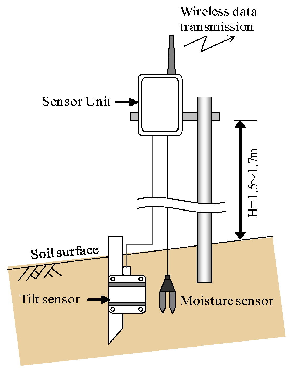
The schematic figure (
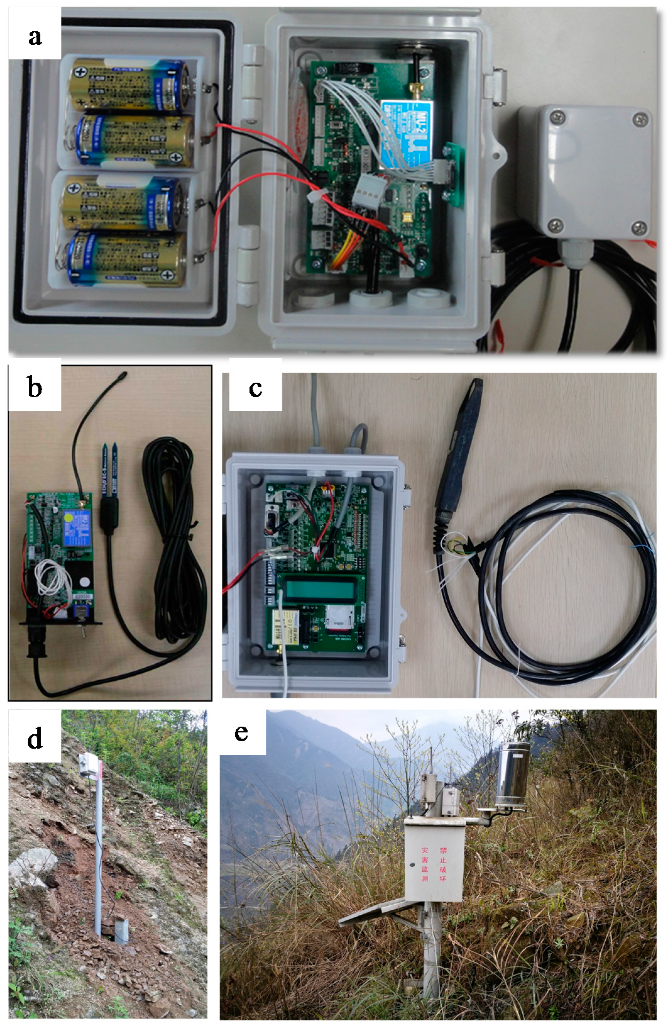
Figure 1) describes a portable and cost-effective multi-source wireless monitoring system for measuring several state variables, which is including the rainfall intensity, soil moisture content, matric suction and inclination of slope. The device of the system can be directly installed and stabilized in the slope, and the sensor units that can be inserted into the soil by using a small hammer. The sensor unit is small in size (16 × 12 × 8 cm) and easy to install. The weight of the sensor unit shown in
Figure 2a is only 400 g, so that the proposed system can be used extensively in hard-reached places in a landslide-prone area. The system can measure multivariable parameters at certain points on a slope surface at the same time. The total cost for one monitoring site including a soil moisture sensor is only 1500 US dollars, far below the conventional GPS system that costs around 6000 US dollar for a single device. The system can be powered with batteries, and the real-time data can be transferred via a wireless network, providing all the data to the internet on time. The applicability and effectiveness of the multi-source wireless monitoring system have been tested in a natural slope under heavy artificial rainfall [
17]. Considering the proposed system is cost-effective and easy to install, it can be widely used in large-scale landslide-prone areas in developing countries.
2.1.1. Wireless Data Transmit Method
Figure 2 shows a sensor unit of the wireless device installed into a landslide site. One unit consists of a MEMS tilt sensor, and is compatible with different sensors. A sensor unit can work automatically with a microcomputer powered by solar cells or independent batteries. The 434 MHz ISM band radio modems have 127 pre-programmed channels, an alternative 1/10 mW power source, and they fit the European Radio and Telecommunications Equipment (R&TTE) Directive and the European Conformity (CE) Marking. They are integrated in the proposed sensor unit, therefore the sensor unit is capable of creating a series of wireless data transmit systems, from simple control systems to wide network systems. The sensor units collect real-time data every 10 min in rainy season and every 1 h in the dry season. The data can be transferred to a gateway unit placed next to the monitoring slope, by adopting energy-saving radio modules. The gateway unit receives data from all the sensor units installed, and transfers data to a server through a mobile network. The distance for data communication is more than 300 m in field circumstances. Therefore, monitoring data can be acquired anywhere and anytime via the internet. The data is arranged in time, and any abnormal variation of the parameters in the slope can be observed as a precaution of possible failure when the thresholds are identified.
2.1.2. Micro Electro Mechanical Systems (MEMS) Based Sensor Unit
In each sensor unit, the MEMS tilt sensors can observe the rotation and abnormal displacement on the ground surface, which avoids the usage of a long extensometer wire. The installation and maintenance is relatively simple and cost-effective. The resolution of the MEMS tilt sensor is sufficient for landslide research, its measurement range is ±30 degrees and the resolution of rotation angle is 0.0025 degree. High resolution, low noise and low temperature dependency, together with a robust sensing element design make this MEMS based inclinometer an appropriate choice to detect slope displacements and failures.
Despite the displacements, the slope stability mechanism indicates that the soil matric suction and water content are significant for the state of stress and stability in shallow slopes, and the correlation of soil moisture and suction can manifest the soil hydraulic characteristics, so that both the soil moisture and the soil suction are essential for monitoring of rainfall-induced landslides. The soil moisture is detected at a shallow position of the slope, typically 30 cm deep. The soil moisture sensor measures volumetric moisture contents by detecting the corresponding dielectric constant of the surrounding soil. In addition, measurements of soil suction in unsaturated soils as well as precipitation are also achievable with the sensor unit by using tensiometers and rain gauges which do not need frequent maintenance. In this study, the measuring range of the soil moisture sensor (Decagon EC-5, Decagon Devices, Pullman, WA, USA) is technically 0–1 with an accuracy of ±0.01, and the measuring range of the soil suction sensor (Tensiomark TS2, Stevens Water Monitoring Systems, Portland, OR, USA) is 0–300 kPa with an accuracy of approximately ±0.15 kPa. The rain gauges (CAWS 100, Huayun Group, Beijing, China) can measure rainfall with a resolution of 0.2 mm and a 0–4 mm/min measurement range. These sensors can be integrated with the wireless sensor unit into the real-time monitoring system and are capable of detecting the magnitudes of the values of the parameters in this area.
2.1.3. Low Power Consumption Design
To design a cost-effective and easy-maintaining monitoring system, the power consumption of the CPU controller is also important., The 16-bit Ultra-Low-Power Microcontroller unit (MCU) (MSP430, Texas Instruments, Dallas, TX, USA, 1996), which includes extensive performance of 7 channel 12 bit Analog-to-Digital converters with synchronization, and 2 USART (Universal Asynchronous Receiver/Transmitter), pronounced I-two-C (I2C) modules, were integrated into the sensor unit. This MCU is ultra power-saving in standby mode with an electricity current intensity of 1.1 uA, and can operate at a low supply-voltage range from 1.8 to 3.6 Volt, thus it is very suitable to work in the field where commercial power is unavailable. 4 Standard Power 7 Alkaline batteries can keep a single sensor unit continuously working for more than 1 year. By attaching an optional solar battery, which costs around 5 US dollar, the sensor unit can work semi-permanently without changing the batteries.
2.2. Case Study
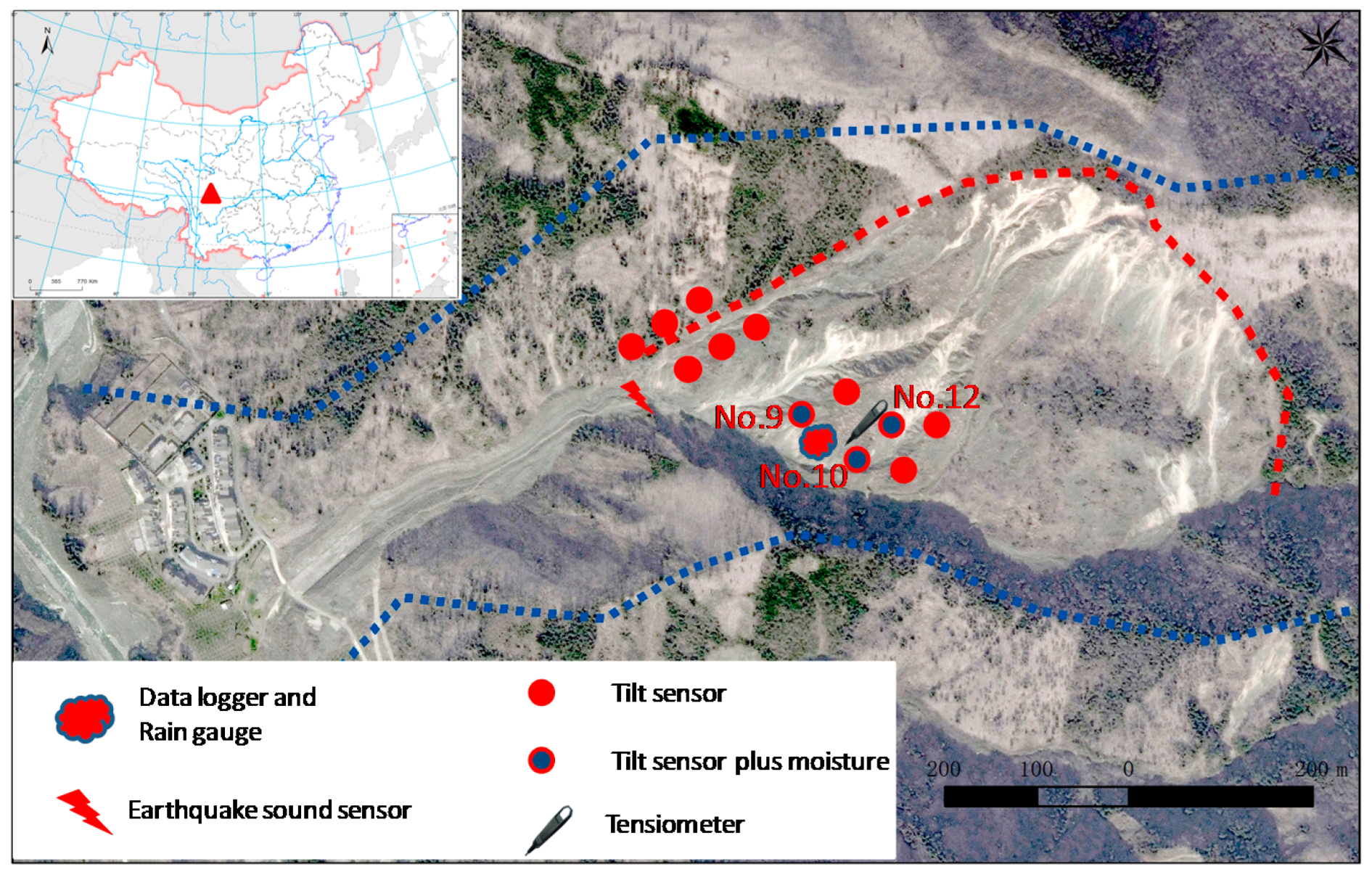
The proposed real-time monitoring systems with automated instrumentation, which allows for remote observations to be collected wirelessly, have been of great value in monitoring landslide-triggering under the impact of precipitation and soil moisture dynamics. However, the limitation of such a system is that it is suitable for monitoring and early warning for shallow landslides, thus this system can only have a superficial record of variables. In this study, this system was tested and established on a real landslide-prone slope in the Wenchuan earthquake region, China. The in situ monitoring slope is located in the catchment of the Yindongzi valley in Dujiangyan County, in the central part of Sichuan Province (
Figure 3). The monitoring catchment is situated in the subtropical humid monsoon climate zone, with an annual average temperature of 16.7°. The annual average rainfall is more than 1200 mm. Precipitation is mostly concentrated in the period from May to September. The landform of the Yindongzi valley can be categorized into middle mountains, the elevation ranges from a minimum of 1030 m above sea level (a.s.l.) to a maximum of 2050 m a.s.l. with about 1000 m height difference along a 2500 m gully length. The strata exposed are from the Proterozoic era, which include igneous rocks, andesitic rocks and granite. The slope failure was triggered by the Wenchuan earthquake and is composed of deeply weathered granite and andesitic gravel and sand. The total volume of this landslide is about 500,000 m
3. After the Wenchuan earthquake, the landslide’s body was remobilized and transformed into debris flows during subsequent rainstorms. These storms exceeded 130 mm over 24 h on 13 August 2009, 17 July 2010 and 9 July 2013 respectively. The Yindongzi landslide and the secondary debris flows threaten the totally rebuilt community residences of Lianhe Village, Dujiangyan County.
A total of 15 sets of equipment were installed to collect real-time data for the Yindongzi landslide (
Figure 3). In May 2014, a real-time monitoring system of multiple parameters including inclination, rainfall, ground vibration and hydrologic measurements were installed in the shallow subsurface of the Yindongzi landslide site in Dujiangyan. In this landslide, 3 soil moisture sensors were installed with NO. 9, 10 and 12 tilt sensors. In particular, the NO. 12 moisture sensors were installed with a tensiometer to study the hydraulic characteristics of the soil. Moreover, a ground vibration detector was installed on 24 April 2016, to record the number of responses when ground vibrations overpassing the acceleration threshold of 0.375 g were detected. These may possibly have been induced by the bounce and tumble motion of the landslide against the underlying ground (
Figure 3). Although the installed sensors were at risk of break-down due to the extreme humidity and temperature in the field, most of the sensors have worked normally with limited maintenance. The monitoring system has been collecting real-time data and long-term changes of precipitation and soil moisture at the Yindongzi landslide site from 21 May 2014 to 22 August 2017. However, our monitoring tilt sensor has not observed any positive displacements during the monitoring period, nor any changes in inclination. As a result, the tilt data are not shown and discussed in this paper.
2.3. Slope Stability Analysis
For transient infiltration conditions, the factor of safety
Fs (-) at a depth
Z (m) below the ground surface at time
t (day) is given by the following equation:
where
ϕ’ (°) is the angle of internal friction for effective stress,
β (°) is the slope angle,
c’ (kPa) is the effective cohesion,
γs (N/m
3) is the soil unit weight,
γw (N/m
3) is the water unit weight,
θ (-) is soil moisture content, and
σs (kPa) is the suction stress defined by Lu and Gods [
6]:
where
Se (-) is the effective degree of saturation,
ψ (kPa) is the matric suction. The hydro-mechanical infinite-slope stability analysis is based on the factor of safety approach coupling the Brooks–Corey equations [
18] and suction stress [
6] in variably saturated soils.
and
a (kPa
−1),
l (-),
n (-), are fitting parameters.
The soil parameters for the slope stability analysis from the topsoil of the slope and parameterization of soil hydraulic properties for the hydro-mechanical models [
19] are based on the soil water characteristic curves (SWCC). Its parameters of hydrology are presented in
Table 1.
3. Results & Discussions
3.1. Field Monitoring Results
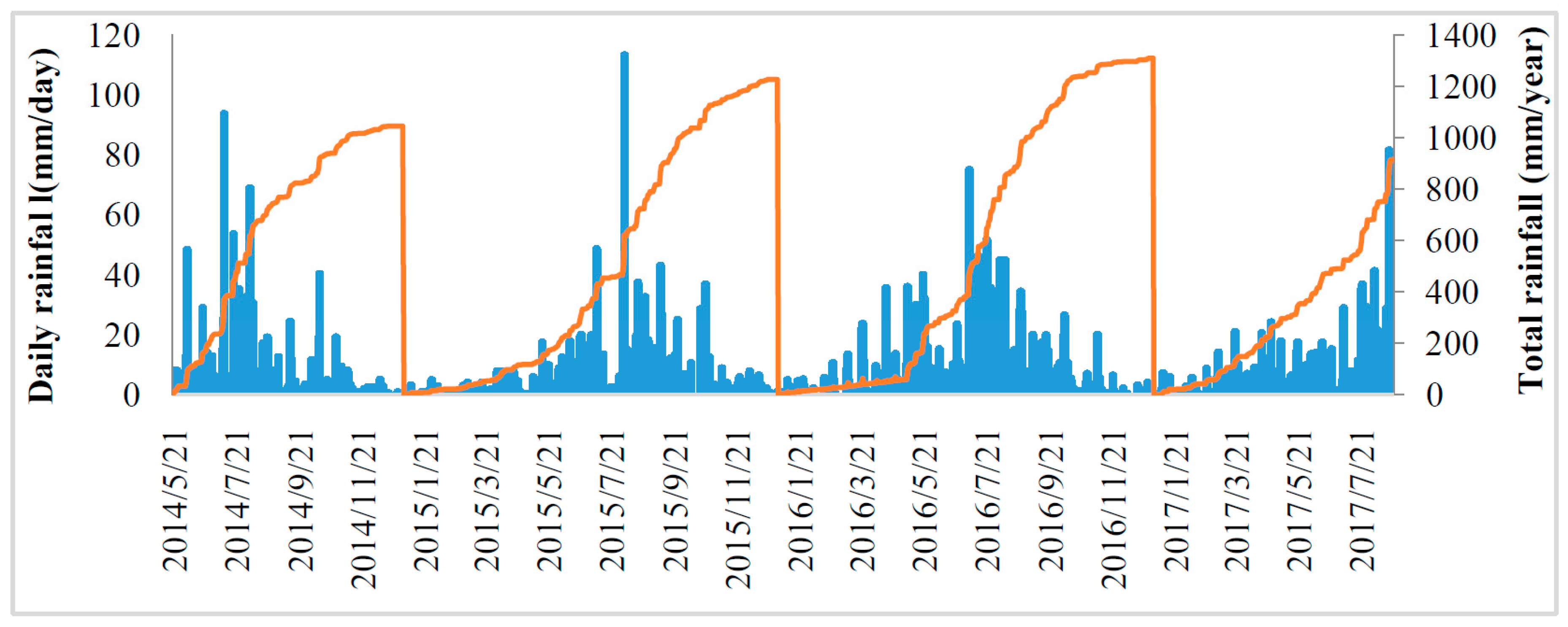
Long-time series data of precipitation and volumetric water content at the Yindongzi landslide site during a four-year period from 21 May 2014 to 22 August 2017 were observed.
Figure 4 shows the daily rainfall and accumulated annual rainfall during the monitoring period.
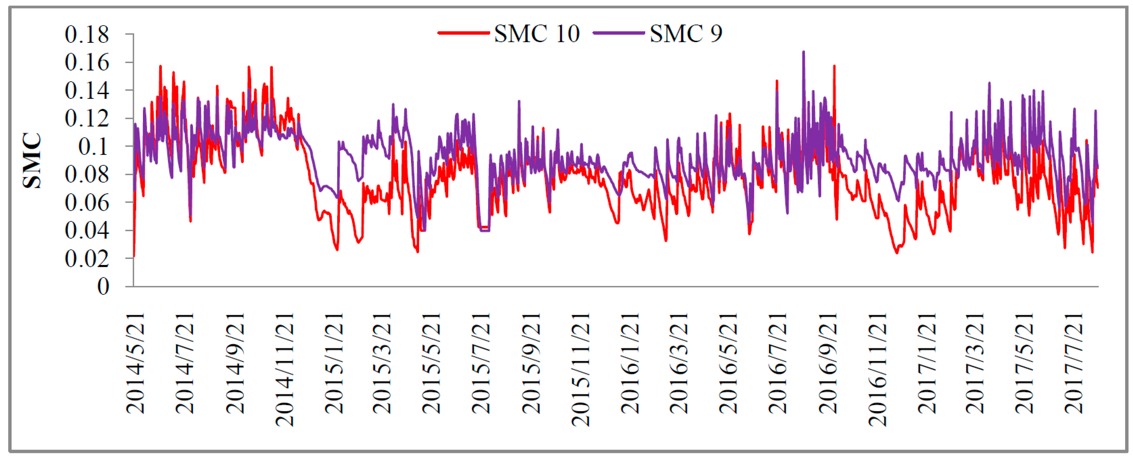
The real-time monitoring has shown that the soil moisture content is strongly related to rainfall. Precipitation was notably seasonal, most of the precipitation was observed during the monitoring period, with most precipitation from May to September. Particularly, an extreme daily rainfall of 113 mm was recorded on 4 August 2015, while the rainfall intensity is lower than that in 2008 to 2013, and the maximum value of daily rainfall is recorded to be 250 mm in this area on 7 July 2013. This explains why there are no debris flows during these years, considering the rainfall intensity and total amount of rainfall may not be sufficient to cause displacements and inclination during the monitoring period. The soil moisture fluctuated significantly during the wetting and drying periods caused by evaporation and infiltration processes. Soil wetness increased episodically with respect to rainfall. Theoretically, the soil moisture content may exceed 0.45, because the porosity of the topsoil is reported to reach 0.49 in this area [
20]. In the analyzed period, the soil moisture content ranged between about 0.03 and 0.17 in the topsoil. During the rainy season, soil moisture storage increased rapidly by an additional 5–13% caused by rainfall (
Figure 5).
3.2. Soil Water Characteristic Curves (SWCC)
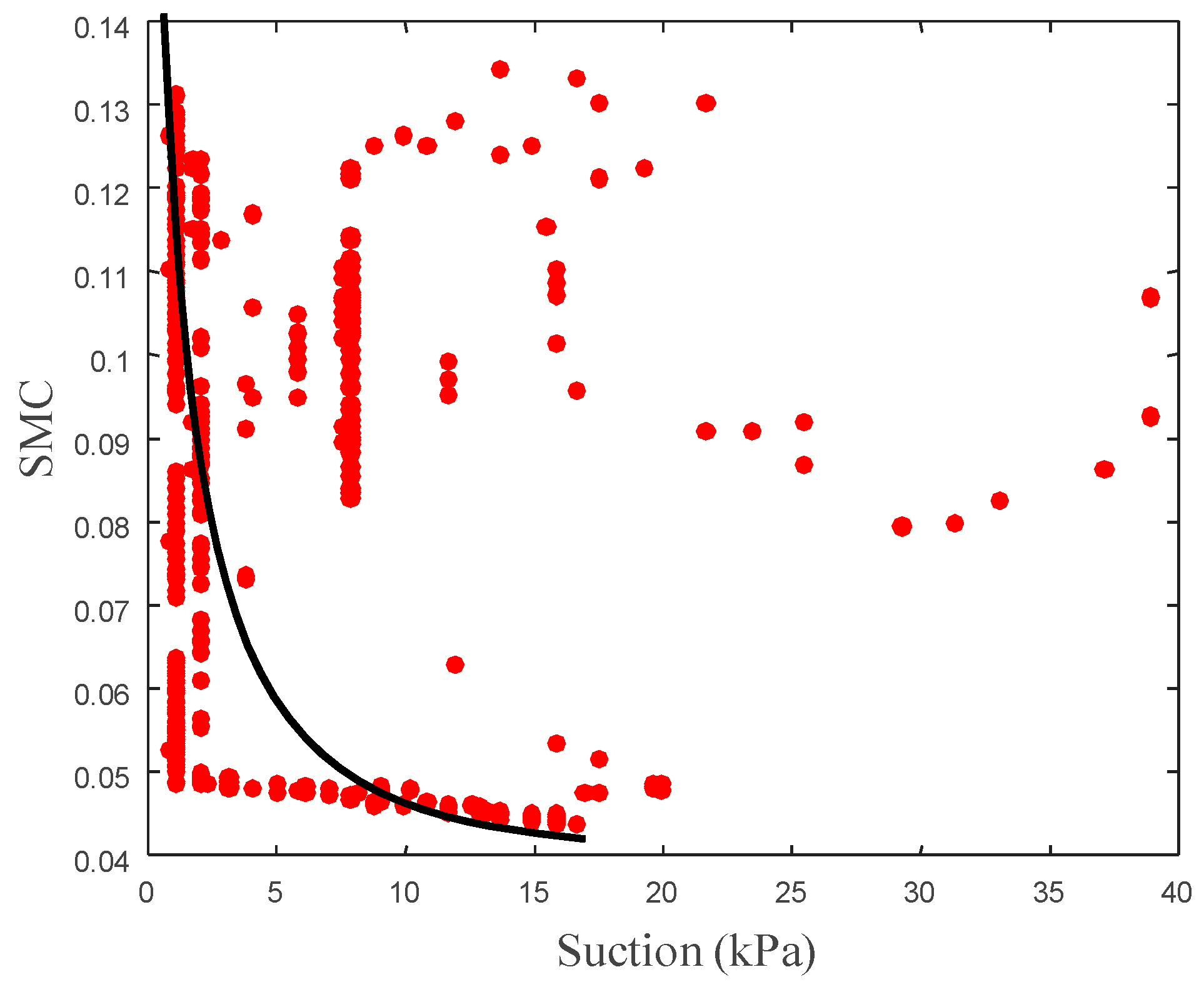
The SWCC of wide-gapped topsoil in the Yindongzi landslide site describes the relations between the matric suction and moisture content, and it can be quantified by the data measured by the tensiometer, as well as moisture in exactly the same location.
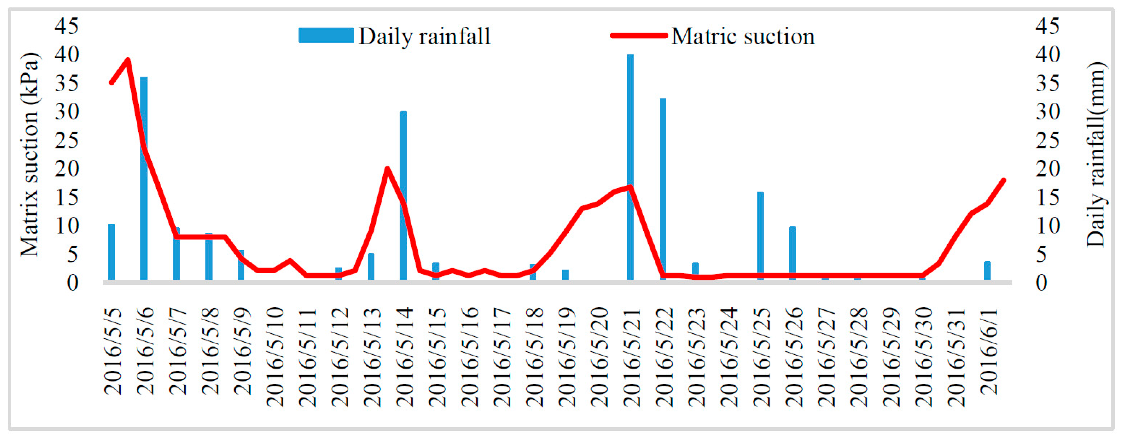
Figure 6 shows that the precipitation and soil suction exhibited different trends during the wetting and drying periods. The topsoil of the natural slope frequently underwent drying and wetting processes. Although instrumentation breakdown occurred after one month of installation, resulting in the loss of matric suction data, some suction data is still available from the period of 5 May to 1 June 2016, when the soil suction underwent notable changes following rainfall events that exceeded about 39 mm in 24 h at its maximum (
Figure 6). During this period, the soil moisture content fluctuated rapidly by an additional 0.01~0.08, and matric suction also underwent a homologous change by 2~40 kPa in response to rainfall. Therefore, the SWCC can be established according to the monitoring soil wetness and matric suction.
Figure 7 shows the estimated SWCC based on the Brooks-Corey model [
18].
Table 1 provides the parameters for the unsaturated topsoil in the Yindongzi landslide site for slope stability analysis, the SWCC parameters were estimated by the in situ moisture and suction data, and soil mechanic parameters were determined by triaxial shear test. As shown in this table, the value of α is high, whereas the values of n are small, especially for the wetting process. The result is similar to a recent study of the SWCC of a wide gapped gravel loamy landslide in the Wenchuan earthquake region [
20], which is reasonable for a post-earthquake landslide deposit, because the landslide is composed of gravelly loamy soil, features a smaller air-entry pressure due to the scarcity of fine grains and a broad grain-size distribution. The air-entry pressure (1/
α) was found to be 0.09 kPa.
3.3. Slope Stability Analysis of the Unsaturated Slope
The slope stability analysis under partially saturated conditions is based on the factor of safety approach combining the hydrological and soil-mechanical analyses. Classical methods for rainfall-triggered shallow slope stability analysis can also be extended to unsaturated conditions by considering the suction stress in this study [
6].
The transient effect of infiltration on the factor of safety is shown in
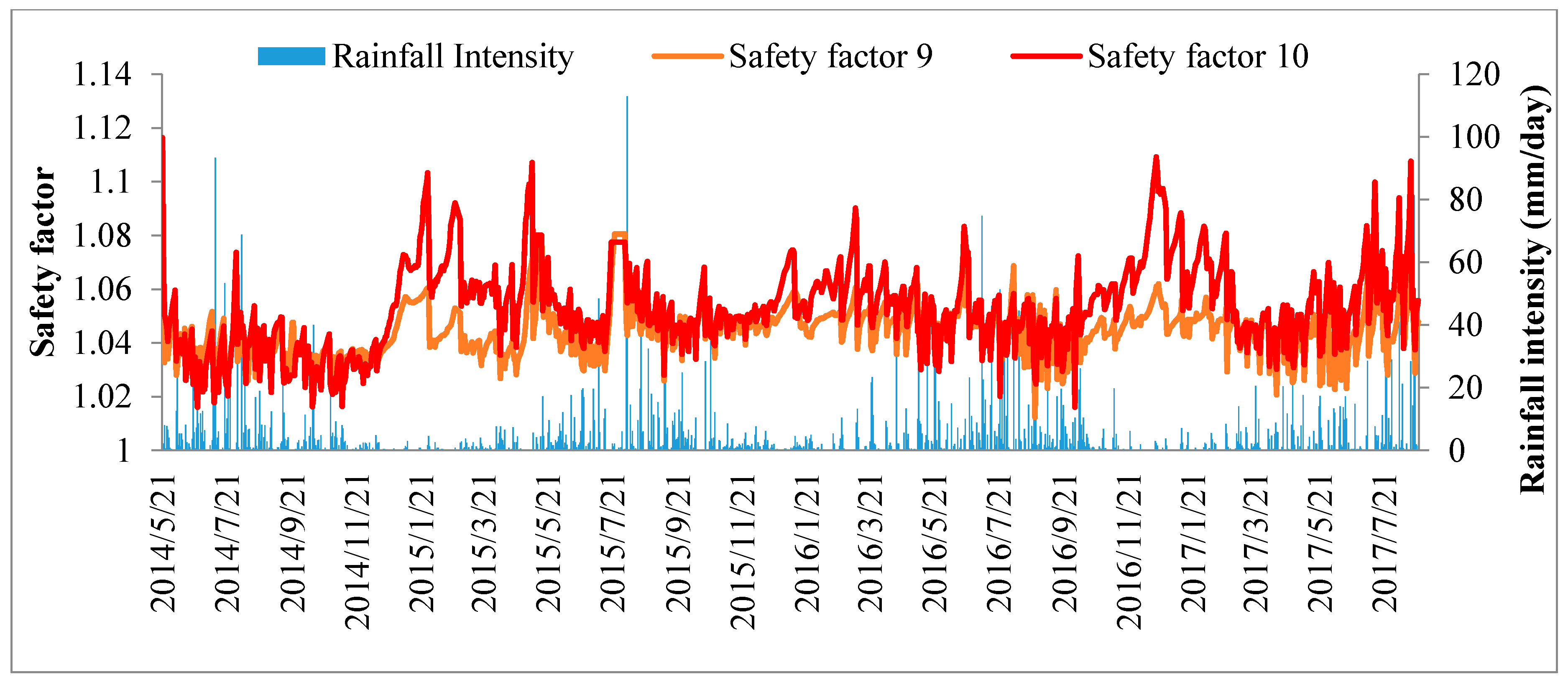
Figure 8. The safety factor of the slope ranged mainly from 1.01 to 1.25 between May 2014 and August 2017.
Figure 8 shows the safety factor of the corresponding monitoring slope considering the suction stress in the unsaturated condition. The safety factor of the slope featured continuous fluctuations due to the variations of the suction stress in response to the rainfall-infiltration and evaporation in the unsaturated topsoil. Correspondingly, the ground vibration detector has recorded responses during the rainy periods. Particularly
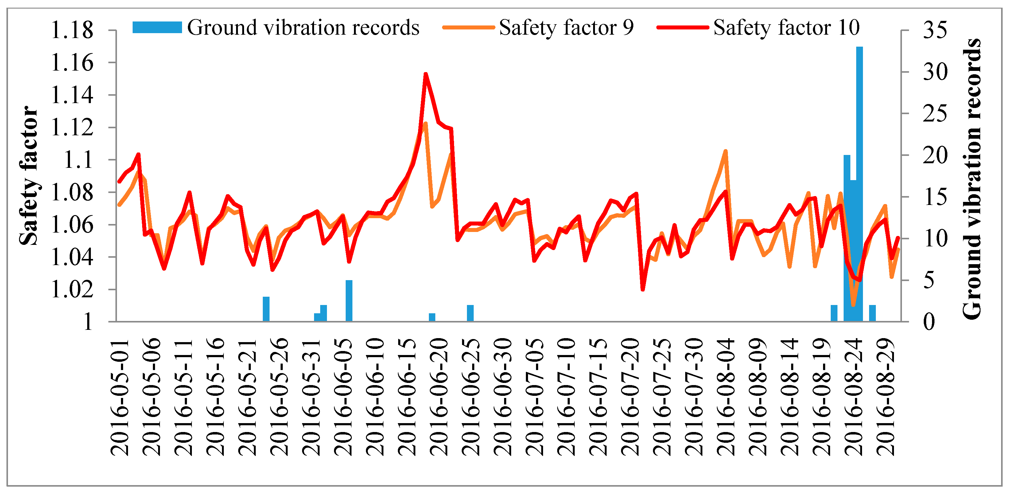
Figure 9 shows that ground vibrations caused 20, 17 and 33 responses to be recorded (70 responses in total) from 23 August to 25 August 2016 as a result of precipitation of 27.8 mm, 34.2 mm, and 27.4 mm on those days (89.4 mm in total). The modeled factor of safety dropped to the lowest point of 1.01 during these days. The evidence of ground vibration responses must have been due to some small-scale slope instability. When the modeled factors of safety came close to unity, it indicated the quasi-stable state of the slopes.
3.4. Hydrological Thresholds
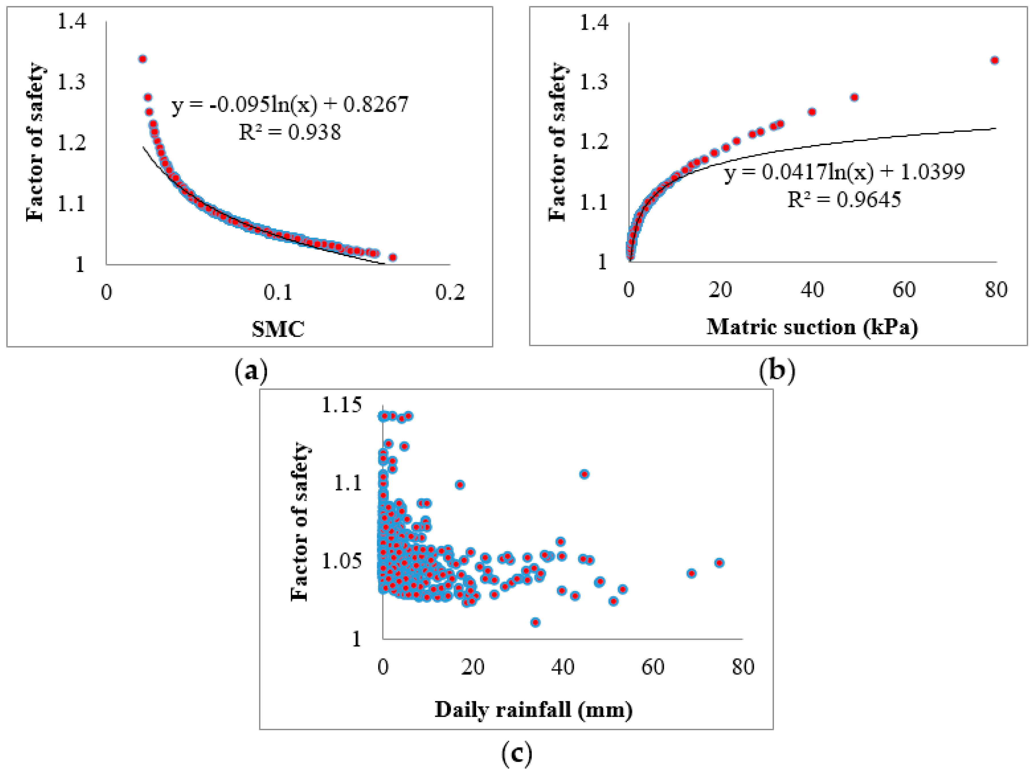
Figure 10 illustrated the correlations of factor of safety with soil moisture content, matric suction, and daily rainfall. The results indicated that the thresholds of volumetric water content and matric suction for triggering landslides were about 0.16 and 2 kPa respectively. However, the correlation of factor of safety with daily rainfall exhibited a rather poor relationship. The hydrological processes and slope stabilities were affected by infiltration, evaporation, drainage, soil hydraulic properties, and the antecedent rainfall, all these factors brings uncertainty in the statistical rainfall threshold. The rainfall threshold shall be calculated by including long-term historical monitoring information [
11]. By means of the in situ big data analysis and slope stability analysis of partial saturation in response to rainfall infiltration, the hydrological parameter criteria of moisture content and matric suction for early warning of rainfall-induced shallow landslides in the Wenchuan earthquake regions can be established by coupling the factor of safety with these parameters.
4. Conclusions
An early warning system of MEMS based multi-source wireless monitoring for rainfall-induced landslides is proposed. This system was tested and established on a real landslide-prone slope in the Wenchuan earthquake region, China, and long-term monitoring data was observed.
(1) The proposed real-time monitoring system is composed of low-cost and portable wireless sensor units, which, when integrated with a MEMS based inclinometer, tensiometer, rainfall gauge and soil moisture sensor, renders the system capable of measuring multi-source parameters corresponding to rainfall-induced landslides. The sensor unit features ultralow power consumption so as to be easy-to-maintain for landslide monitoring.
(2) The long-term fluctuations in the soil moisture content, matric suction, and rainfall were observed and slope stability in response to rainfall infiltration was simulated. The corresponding slope failures during a rainy period could have been were observed by ground vibration, indicating that the reduction in matric suction and the rise in soil moisture in response to rainfall infiltration contributes enormously to slope stability of rainfall-triggered landslides, especially in terms of shallow mass movement.
(3) Based on instrumental field observations and the quantitative slope stability analysis for an unsaturated slope, a method to determine multi-source thresholds of hydrological parameters, including daily rainfall intensity, soil moisture content and matric suction, for use as early warning criteria for rainfall-induced landslides in the Wenchuan earthquake region was proposed.
The proposed explorations indicate that field measurements and a threshold model including precipitation, soil wetness, and pore pressure (soil suction) are significant in identifying states under which rainfall-induced landslides are likely to initiate. The proposed low-cost and effective early warning method combined with a multi-parameter threshold for anticipating rainfall-induced landslide activity provide powerful tools to conduct a landslide early warning system that could be adopted to reduce landslide risk.
Acknowledgments
This work was financially supported by the National Natural Science Foundation of China (Grant No. 41771021, 41471012) and the Hundred Young Talents and 135 Strategic Program of IMHE (Grant No. SDSQB-2016-01, SDS-135-1701, SDS-135-1704), and Science and Technology Service Network Initiative of Chinese Academy of Science (Grant No. KFJ-EW-STS-094, KFJ-STS-ZDTP-015). The Field Observation and Research Base of Geological Hazards in Chengdu Earthquake Disturbed Area of Longmen Mountain, Ministry of Land and Resources of China provided some data for this work.
Author Contributions
Zongji Yang and Taro Uchimura conceived and designed the early warning system; Zongji Yang, Jianping Qiao, Dong Huang, and Hongling Tian established and performed the early warning system; Wei Shao and Xiaoqin Lei contributed analysis tools; Zongji Yang wrote the paper.
Conflicts of Interest
The authors declare no conflict of interest.
References
- Arosio, D.; Longoni, L.; Papini, M.; Scaioni, M.; Zanzi, L.; Alba, M. Towards rockfall forecasting through observing deformations and listening to microseismic emissions. Nat. Hazards Earth Syst. Sci. 2009, 9, 1119–1131. [Google Scholar] [CrossRef]
- Fan, Y.B.; Yang, S.W.; Xu, L.K.; Li, S.H.; Feng, C.; Liang, B.F. Real-time monitoring instrument designed for the deformation and sliding period of colluvial landslides. Bull. Eng. Geol. Environ. 2017, 76, 829–838. [Google Scholar] [CrossRef]
- Segalini, A.; Chiapponi, L.; Pastarini, B.; Carini, C. Automated inclinometer monitoring based on micro electro-mechanical system technology: Applications and verification. In Landslide Science for a Safer Geoenvironment; Sassa, K., Canuti, P., Yin, Y., Eds.; Springer: Cham, Switzerland, 2014; pp. 595–600. [Google Scholar]
- Pumo, D.; Francipane, A.; Conti, F.L.; Arnone, E.; Bitonto, P.; Francesco, V.; la Loggia, G.; Noto, L.V. The SESAMO early warning system for rainfall-triggered landslides. J. Hydroinform. 2016, 18, 256–276. [Google Scholar] [CrossRef] [Green Version]
- Tang, C.; Zhu, J.; Li, W.L.; Liang, J.T. Rainfall-triggered debris flows following the Wenchuan earthquake. Bull. Eng. Geol. Environ. 2009, 68, 187–194. [Google Scholar] [CrossRef]
- Lu, N.; Godt, J.W. Hillslope Hydrology and Stability; Cambridge University Press: Cambridge, UK, 2013. [Google Scholar]
- Godt, J.W.; Baum, R.L.; Lu, N. Landsliding in partially saturated materials. Geophys. Res. Lett. 2009, 36. [Google Scholar] [CrossRef]
- Iverson, R.M. Landslide triggering by rain infiltration. Water Resour. Res. 2000, 36, 1897–1910. [Google Scholar] [CrossRef]
- Iverson, R.M.; Reid, M.E.; La Husen, R.G. Debris-flow mobilization from landslides. Annu. Rev. Earth Planet. Sci. 1997, 25, 85–138. [Google Scholar] [CrossRef]
- Huang, R. After effect of geohazards induced by the Wenchuan earthquake. J. Eng. Geol. 2011, 19, 145–151. [Google Scholar]
- Yang, Z.J.; Qiao, J.P.; Tian, H.L. Real-time regional rainfall induced Geohazards prediction method in the Wenchuan earthquake region, China. Disaster Adv. 2012, 5, 408–454. [Google Scholar]
- Song, Y.S.; Chae, B.G.; Lee, J. A method for evaluating the stability of an unsaturated slope in natural terrain during rainfall. Eng. Geol. 2016, 210, 84–92. [Google Scholar] [CrossRef]
- Bordoni, M.; Meisina, C.; Valentino, R.; Lu, N.; Bittellid, M.; Chersicha, S. Hydrological factors affecting rainfall-induced shallow landslides: From the field monitoring to a simplified slope stability analysis. Eng. Geol. 2015, 193, 19–37. [Google Scholar] [CrossRef]
- Tiranti, D.; Rabuffetti, D.; Salandin, A.; Tararbra, M. Development of a new translational and rotational slides prediction model in Langhe hills (north-western Italy) and its application to the 2011 March landslide event. Landslides 2013, 10, 121–138. [Google Scholar] [CrossRef]
- Shao, W.; Ni, J.J.; Leung, A.K.; Su, Y.; Ng, C.W.W. Analysis of plant root-induced preferential flow and pore water pressure variation by a dual-permeability model. Can. Geotech. J. 2017, 1–16. [Google Scholar] [CrossRef]
- Shao, W.; Bogaard, T.A.; Bakker, M.; Berti, M. Analysing the influence of preferential flow on pressure propagation and landslide triggering of Rocca Pitigliana landslide. J. Hydrol. 2016, 543, 360–372. [Google Scholar] [CrossRef]
- Uchimura, T.; Towhata, I.; Anh, T.T.L.; Fukuda, J.; Bautista, C.J.B.; Wang, L.; Seko, I.; Uchida, T.; Matsuoka, A.; Ito, Y.; et al. Simple monitoring method for precaution of landslides watching tilting and water contents on slopes surface. Landslides 2010, 7, 351–357. [Google Scholar] [CrossRef]
- Brooks, R.H.; Corey, A.T. Hydraulic Properties of Porous Media; Colorado State University: Fort Collins, CO, USA, 1964. [Google Scholar]
- Baum, R.L.; Godt, J.W.; Savage, W.Z. Estimating the timing and location of shallow rainfall-induced landslides using a model for transient, unsaturated infiltration. J. Geophys. Res. 2010, 115, F03013. [Google Scholar] [CrossRef]
- Yang, Z.J.; Qiao, J.P.; Uchimura, T.; Wang, L.; Lei, X.Q.; Huang, D. Unsaturated hydro-mechanical behaviour of rainfall-induced mass remobilization in post-earthquake landslides. Eng. Geol. 2017, 222, 102–110. [Google Scholar] [CrossRef]
Figure 1.
Wireless sensor unit with tilt and water content sensors on a slope, rain gauge and tensiometer are also compatible with the sensor unit as an alternative.
Figure 1.
Wireless sensor unit with tilt and water content sensors on a slope, rain gauge and tensiometer are also compatible with the sensor unit as an alternative.
Figure 2.
Pictures of instruments proposed for landslide real-time monitoring and early warning system. (a) The tilt sensors, (b) soil moisture sensors and (c) tensiometer integrated with (d) sensor unit and installed at the head of the slope in hollow in Yindongzi landslide and (e) a tipping bucket rain gauge was connected to the data logger.
Figure 3.
Location of the in situ monitoring site, which is conducted on a natural landslide site in Yindongzi valley, Dujiangyan County, Chengdu City, Sichuan Province, China.
Figure 3.
Location of the in situ monitoring site, which is conducted on a natural landslide site in Yindongzi valley, Dujiangyan County, Chengdu City, Sichuan Province, China.
Figure 4.
Daily and accumulative rainfall were recorded by the rain gauge at the Yindongzi landslide site from 21 May 2014 to 22 August 2017. Instruments were installed on 3 May 2014 and data collection began on 19 May 2014.
Figure 4.
Daily and accumulative rainfall were recorded by the rain gauge at the Yindongzi landslide site from 21 May 2014 to 22 August 2017. Instruments were installed on 3 May 2014 and data collection began on 19 May 2014.
Figure 5.
Soil moisture content (SMC) recorded by soil moisture sensors (Decagon EC-5) at the Yindongzi landslide site from 21 May 2014 to 22 August 2017.
Figure 5.
Soil moisture content (SMC) recorded by soil moisture sensors (Decagon EC-5) at the Yindongzi landslide site from 21 May 2014 to 22 August 2017.
Figure 6.
Times series of the daily rainfall and matric suction observed by real-time monitoring sensors from 5 May to 23 May 2016 in the top soil of the landslide monitoring site.
Figure 6.
Times series of the daily rainfall and matric suction observed by real-time monitoring sensors from 5 May to 23 May 2016 in the top soil of the landslide monitoring site.
Figure 7.
Soil water characteristic curves (SWCC) of the Brooks–Corey model in the top soil of landslide monitoring site over the analyzed period.
Figure 7.
Soil water characteristic curves (SWCC) of the Brooks–Corey model in the top soil of landslide monitoring site over the analyzed period.
Figure 8.
Modeled factors of safety based on fluctuation of suction stress for different position in the slope during 21 May 2014 to 22 August 2017.
Figure 8.
Modeled factors of safety based on fluctuation of suction stress for different position in the slope during 21 May 2014 to 22 August 2017.
Figure 9.
Ground vibration records and modeled factor of safety changes in the Yindongzi landslide site from 1 May to 30 August 2016.
Figure 9.
Ground vibration records and modeled factor of safety changes in the Yindongzi landslide site from 1 May to 30 August 2016.
Figure 10.
Correlation of slope stability and soil moisture content, matric suction and daily rainfall, plotting by the stability analysis. Modeled factor of safety versus (a) observed volumetric water content, (b) observed suction and (c) observed daily rainfall which indicates the water contents and suction thresholds models for early warning of the mass-remobilization in the Yindongzi landslide site in hollows of debris flows of the Wenchuan earthquake region.
Table 1.
Soil parameters for the slope stability analysis. SWCC denotes soil water characteristic curves.
Table 1.
Soil parameters for the slope stability analysis. SWCC denotes soil water characteristic curves.
| Symbol | Parameter | Value |
|---|
| c’ | soil cohesion for effective stress; (kPa) | 3.0 |
| ϕ’ | angle of internal friction for effective stress; (°) | 33 |
| γs | dry soil unit weight; (kN/m3) | 15 |
| Slope angle; (°) | 60 |
| residual water content; (-) | 0.05 |
| saturated water content; (-) | 0.45 |
| Z | Soil depth;(m) | 0.5 |
| a | SWCC parameter of the Brooks–Corey model | 11 |
| n | SWCC parameter of the Brooks–Corey model | 0.53 |
© 2017 by the authors. Licensee MDPI, Basel, Switzerland. This article is an open access article distributed under the terms and conditions of the Creative Commons Attribution (CC BY) license (http://creativecommons.org/licenses/by/4.0/).

 ,
, 


