
Land-Use Change Modelling in the Upper Blue Nile Basin


 ,
,
Abstract
:
1. Introduction
2. Materials and Methods
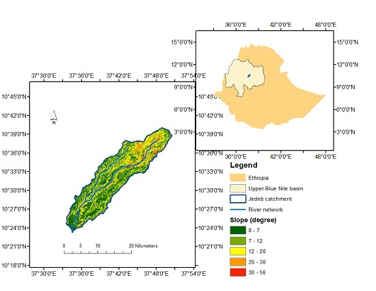
2.1. Study Area
2.2. Conceptual Framework
2.3. Inputs and Model Setup
2.3.1. Model Architecture
2.3.2. Land-Use Change Drivers
2.3.3. Data
2.3.4. Demand for Land Use
2.4. Model Evaluation
2.5. Scenario Development
3. Results and Discussions
3.1. Land-Use Changes and Drivers
3.2. Land-Use Change Rules
3.3. Model Evaluation
4. Conclusions and Recommendations
Acknowledgments
Author Contributions
Conflicts of Interest
References
- Fürst, C.; Helming, K.; Lorz, C.; Müller, F.; Verburg, P.H. Integrated land use and regional resource management—A cross-disciplinary dialogue on future perspectives for a sustainable development of regional resources. J. Environ. Manag. 2013, 127, S1–S5. [Google Scholar] [CrossRef] [PubMed]
- Rindfuss, R.R.; Entwisle, B.; Walsh, S.J.; An, L.; Badenoch, N.; Brown, D.G.; Deadman, P.; Evans, T.P.; Fox, J.; Geoghegan, J. Land use change: Complexity and comparisons. J. Land Use Sci. 2008, 3, 1–10. [Google Scholar] [CrossRef] [PubMed]
- Halmy, M.W.A.; Gessler, P.E.; Hicke, J.A.; Salem, B.B. Land use/land cover change detection and prediction in the north-western coastal desert of Egypt using Markov-CA. Appl. Geogr. 2015, 63, 101–112. [Google Scholar] [CrossRef]
- Turner, K.G.; Anderson, S.; Gonzales-Chang, M.; Costanza, R.; Courville, S.; Dalgaard, T.; Dominati, E.; Kubiszewski, I.; Ogilvy, S.; Porfirio, L. A review of methods, data, and models to assess changes in the value of ecosystem services from land degradation and restoration. Ecol. Model. 2016, 319, 190–207. [Google Scholar] [CrossRef]
- Ellis, E.; Pontius, R. Land-use and land-cover change. In Encyclopedia of Earth; Springer: Washington, DC, USA, 2007. [Google Scholar]
- Geist, H.J.; Lambin, E.F. Proximate Causes and Underlying Driving Forces of Tropical Deforestation: Tropical forests are disappearing as the result of many pressures, both local and regional, acting in various combinations in different geographical locations. BioScience 2002, 52, 143–150. [Google Scholar] [CrossRef]
- Veldkamp, A.; Lambin, E.F. Predicting land-use change. Agric. Ecosyst. Environ. 2001, 85, 1–6. [Google Scholar] [CrossRef]
- Rendana, M.; Rahim, S.A.; Idris, W.M. R.; Lihan, T.; Rahman, Z.A. CA-Markov for Predicting Land Use Changes in Tropical Catchment Area: A Case Study in Cameron Highland, Malaysia. J. Appl. Sci. 2015, 15, 689. [Google Scholar] [CrossRef]
- Chen, H.; Pontius, R.G., Jr. Diagnostic tools to evaluate a spatial land change projection along a gradient of an explanatory variable. Landsc. Ecol. 2010, 25, 1319–1331. [Google Scholar] [CrossRef]
- Pontius, R.G., Jr.; Boersma, W.; Castella, J.-C.; Clarke, K.; de Nijs, T.; Dietzel, C.; Duan, Z.; Fotsing, E.; Goldstein, N.; Kok, K. Comparing the input, output, and validation maps for several models of land change. Ann. Reg. Sci. 2008, 42, 11–37. [Google Scholar] [CrossRef]
- Asres, R.S.; Tilahun, S.A.; Ayele, G.T.; Melesse, A.M. Analyses of Land Use/Land Cover Change Dynamics in the Upland Watersheds of Upper Blue Nile Basin. In Landscape Dynamics, Soils and Hydrological Processes in Varied Climates; Springer: Berlin, Germany, 2016; pp. 73–91. [Google Scholar]
- Abegaz, A.; Winowiecki, L.A.; Vågen, T.-G.; Langan, S.; Smith, J.U. Spatial and temporal dynamics of soil organic carbon in landscapes of the upper Blue Nile Basin of the Ethiopian Highlands. Agric. Ecosyst. Environ. 2016, 218, 190–208. [Google Scholar] [CrossRef]
- Jørgensen, L. Advances in Stated Preference Studies for Valuing and Managing the Environment—A Developing Country Context. Ph.D. Thesis, University of Copenhagen, København, Denmark, 23 November 2015. [Google Scholar]
- Tesfaye, A.; Negatu, W.; Brouwer, R.; Zaag, P. Understanding soil conservation decision of farmers in the Gedeb watershed, Ethiopia. Land Degrad. Dev. 2014, 25, 71–79. [Google Scholar] [CrossRef]
- Bewket, W. Land cover dynamics since the 1950s in Chemoga watershed, Blue Nile basin, Ethiopia. Mt. Res. Dev. 2002, 22, 263–269. [Google Scholar] [CrossRef]
- Hurni, H.; Tato, K.; Zeleke, G. The implications of changes in population, land use, and land management for surface runoff in the upper Nile basin area of Ethiopia. Mt. Res. Dev. 2005, 25, 147–154. [Google Scholar] [CrossRef]
- Steenhuis, T.S.; Collick, A.S.; Easton, Z.M.; Leggesse, E.S.; Bayabil, H.K.; White, E.D.; Awulachew, S.B.; Adgo, E.; Ahmed, A.A. Predicting discharge and sediment for the Abay (Blue Nile) with a simple model. Hydrol. Process. 2009, 23, 3728–3737. [Google Scholar] [CrossRef]
- Setegn, S.G.; Srinivasan, R.; Dargahi, B.; Melesse, A.M. Spatial delineation of soil erosion vulnerability in the Lake Tana Basin, Ethiopia. Hydrol. Process. 2009, 23, 3738. [Google Scholar] [CrossRef]
- Schweitzer, C.; Priess, J.A.; Das, S. A generic framework for land-use modelling. Environ. Model. Softw. 2011, 26, 1052–1055. [Google Scholar] [CrossRef]
- Di Gregorio, A. Land Cover Classification System: Classification Concepts and User Manual: LCCS; Food and Agriculture Organization of the United Nationsb (FAO): Rome, Italy, 2005. [Google Scholar]
- Easton, Z.; Fuka, D.; White, E.; Collick, A.; Biruk Ashagre, B.; McCartney, M.; Awulachew, S.; Ahmed, A.; Steenhuis, T. A multi basin SWAT model analysis of runoff and sedimentation in the Blue Nile, Ethiopia. Hydrol. Earth Syst. Sci. 2010, 14, 1827–1841. [Google Scholar] [CrossRef]
- Betrie, G.; Mohamed, Y.; Griensven, A.V.; Srinivasan, R. Sediment management modelling in the Blue Nile Basin using SWAT model. Hydrol. Earth Syst. Sci. 2011, 15, 807–818. [Google Scholar] [CrossRef]
- Tesfaye, A.; Brouwer, R. Testing participation constraints in contract design for sustainable soil conservation in Ethiopia. Ecol. Econ. 2012, 73, 168–178. [Google Scholar] [CrossRef]
- Teferi, E.; Bewket, W.; Uhlenbrook, S.; Wenninger, J. Understanding recent land use and land cover dynamics in the source region of the Upper Blue Nile, Ethiopia: Spatially explicit statistical modeling of systematic transitions. Agric. Ecosyst. Environ. 2013, 165, 98–117. [Google Scholar] [CrossRef]
- Bewket, W.; Teferi, E. Assessment of soil erosion hazard and prioritization for treatment at the watershed level: Case study in the Chemoga watershed, Blue Nile Basin, Ethiopia. Land Degrad. Dev. 2009, 20, 609–622. [Google Scholar] [CrossRef]
- Pankhurst, A. Land Degradation. In Water Resources Management in Ethiopia: Implications for the Nile Basin; Cambria Press: Amherst, NY, USA, 2010; Volume 213. [Google Scholar]
- Mimler, M.; Priess, J.A. Design and Complementation of a Generic Modeling Framework—A Platform for Integrated Land Use Modeling; Kassel University Press GmbH: Kassel, Germany, 2008. [Google Scholar]
- Abdi, H.; Williams, L.J. Principal component analysis. Wiley Interdiscip. Rev. Comput. Stat. 2010, 2, 433–459. [Google Scholar] [CrossRef]
- Abdi, H. Factor rotations in factor analyses. In Encyclopedia for Research Methods for the Social Sciences; Sage: Thousand Oaks, CA, USA, 2003; pp. 792–795. [Google Scholar]
- Jolliffe, I. Principal Component Analysis; Wiley Online Library: Hoboken, NJ, USA, 2005. [Google Scholar]
- Du, X.; Jin, X.; Yang, X.; Yang, X.; Zhou, Y. Spatial pattern of land use change and its driving force in Jiangsu Province. Int. J. Environ. Res. Public Health 2014, 11, 3215–3232. [Google Scholar] [CrossRef] [PubMed]
- Skånes, H.; Bunce, R. Directions of landscape change (1741–1993) in Virestad, Sweden—Characterised by multivariate analysis. Landsc. Urban Plan. 1997, 38, 61–75. [Google Scholar] [CrossRef]
- Serneels, S.; Lambin, E.F. Proximate causes of land-use change in Narok District, Kenya: A spatial statistical model. Agric. Ecosyst. Environ. 2001, 85, 65–81. [Google Scholar] [CrossRef]
- Central Statistical Agency (CSA). Population and Housing Census of Ethiopia; CSA: Addis Ababa, Ethiopia, 2007.
- Chamberlin, J.; Tadesse, M.; Benson, T.; Zakaria, S. An Atlas of the Ethiopian Rural Economy: Expanding the range of available information for development planning. Inform. Dev. 2007, 23, 181–192. [Google Scholar] [CrossRef]
- Dercon, S.; Hoddinott, J. The Ethiopian Rural Household Surveys: Introduction; International Food Policy Research Institute: Washington, DC, USA, 2004. [Google Scholar]
- Ball, G.H.; Hall, D.J. ISODATA, a Novel Method of Data Analysis and Pattern Classification; DTIC Document: Menlo Park, CA, USA, 1965. [Google Scholar]
- FAO. GEONETWORK: Major Soil Groups of the World (FGGD); FAO: Rome, Italy, 2013. [Google Scholar]
- CSA. Summary and Statistical Report of the 2007 Population and Housing Census; Federal Democratic Republic of Ethiopia: Addis Ababa, Ethiopia, 2008.
- FAO. Livestock Sector Brief: Ethiopia; FAO, Livestock Information, Sector Analysis and Policy Branch AGAL: Rome, Italy, 2004. [Google Scholar]
- Mengistu, A. Country Pasture/Forage Resource Profiles of Ethiopia; FAO: Rome, Italy, 2006. [Google Scholar]
- Jayne, T.S.; Yamano, T.; Weber, M.T.; Tschirley, D.; Benfica, R.; Chapoto, A.; Zulu, B. Smallholder income and land distribution in Africa: Implications for poverty reduction strategies. Food Policy 2003, 28, 253–275. [Google Scholar] [CrossRef]
- Wall, M. GAlib: A C++ library of genetic algorithm components. Mech. Eng. Dep. Mass. Inst. Technol. 1996, 87, 54. [Google Scholar]
- Kuhnert, M.; Voinov, A.; Seppelt, R. Comparing raster map comparison algorithms for spatial modeling and analysis. Photogramm. Eng. Remote Sens. 2005, 71, 975. [Google Scholar] [CrossRef]
- Visser, H.; de Nijs, T. The map comparison kit. Environ. Model. Softw. 2006, 21, 346–358. [Google Scholar] [CrossRef]
- Pontius, R.G.; Shusas, E.; McEachern, M. Detecting important categorical land changes while accounting for persistence. Agric. Ecosyst. Environ. 2004, 101, 251–268. [Google Scholar] [CrossRef]
- Hagen-Zanker, A.; Lajoie, G. Neutral models of landscape change as benchmarks in the assessment of model performance. Landsc. Urban Plan. 2008, 86, 284–296. [Google Scholar] [CrossRef] [Green Version]
- Van Vliet, J.; Hagen-Zanker, A.; Hurkens, J.; van Delden, H. A fuzzy set approach to assess the predictive accuracy of land use simulations. Ecol. Model. 2013, 261, 32–42. [Google Scholar] [CrossRef]
- Van Vliet, J.; Bregt, A.K.; Hagen-Zanker, A. Revisiting Kappa to account for change in the accuracy assessment of land-use change models. Ecol. Model. 2011, 222, 1367–1375. [Google Scholar] [CrossRef]
- Pontius, R.G., Jr.; Peethambaram, S.; Castella, J.-C. Comparison of three maps at multiple resolutions: A case study of land change simulation in Cho Don District, Vietnam. Ann. Assoc. Am. Geogr. 2011, 101, 45–62. [Google Scholar] [CrossRef]
- Pontius, R.G., Jr.; Millones, M. Death to Kappa: Birth of quantity disagreement and allocation disagreement for accuracy assessment. Int. J. Remote Sens. 2011, 32, 4407–4429. [Google Scholar] [CrossRef]
- Olmedo, M.T.C.; Pontius, R.G.; Paegelow, M.; Mas, J.-F. Comparison of simulation models in terms of quantity and allocation of land change. Environ. Model. Softw. 2015, 69, 214–221. [Google Scholar] [CrossRef]
- Landis, J.R.; Koch, G.G. The measurement of observer agreement for categorical data. Biometrics 1977, 33, 159–174. [Google Scholar] [CrossRef] [PubMed]
- Altman, D. Comparing groups—Categorical data. Pract. Stat. Med. Res. 1991, 1, 261–265. [Google Scholar]
- FDRE REDD: Proposal Submitted to Forest Carbon Partnership Facility; Forest Carbon Partnership Facility (FCPF): Washington, DC, USA, 2011.
- Kaiser, H.F. The application of electronic computers to factor analysis. Educ. Psychol. Meas. 1960, 20, 141–151. [Google Scholar] [CrossRef]
- Simane, B.; Zaitchik, B.F.; Ozdogan, M. Agroecosystem analysis of the Choke Mountain watersheds, Ethiopia. Sustainability 2013, 5, 592–616. [Google Scholar] [CrossRef]
- Bewket, W.; Abebe, S. Land-use and land-cover change and its environmental implications in a tropical highland watershed, Ethiopia. Int. J. Environ. Stud. 2013, 70, 126–139. [Google Scholar] [CrossRef]
- Tekleab, S.; Wenninger, J.; Uhlenbrook, S. Characterisation of stable isotopes to identify residence times and runoff components in two meso-scale catchments in the Abay/Upper Blue Nile basin, Ethiopia. Hydrol. Earth Syst. Sci. 2014, 18, 2415–2431. [Google Scholar] [CrossRef] [Green Version]
- Tekleab, S.; Mohamed, Y.; Uhlenbrook, S.; Wenninger, J. Hydrologic responses to land cover change: The case of Jedeb mesoscale catchment, Abay/Upper Blue Nile basin, Ethiopia. Hydrol. Process. 2014, 28, 5149–5161. [Google Scholar] [CrossRef]
- Haregeweyn, N.; Tsunekawa, A.; Tsubo, M.; Meshesha, D.; Adgo, E.; Poesen, J.; Schütt, B. Analyzing the hydrologic effects of region-wide land and water development interventions: A case study of the Upper Blue Nile basin. Reg. Environ. Chang. 2016, 16, 951–966. [Google Scholar] [CrossRef]
- Zeleke, G.; Hurni, H. Implications of land use and land cover dynamics for mountain resource degradation in the Northwestern Ethiopian highlands. Mount. Res. Dev. 2001, 21, 184–191. [Google Scholar] [CrossRef]


| Variables | Description | Dataset | Sources * | Scale/Resolution |
|---|---|---|---|---|
| Population | Gridded population dataset | Census for 1986 & 2007; GPW | CSA, FAO | Sub-district; 1 km |
| Livestock | Gridded livestock dataset | Gridded livestock (GLW) 2007, 2014 | FAO | 5 km |
| Distance to roads | Euclidean distance to major roads | Roads | ERA | 30 m |
| Distance to markets | Euclidean distance to major towns | Markets | FAO-SRDN | 30 m |
| Land cover map | Land cover maps | Landsat TM (1986 & 2009) | Teferi et al [24] | 30 m |
| Settlement maps | Topographic map with settlement locations | Topo1984; Landsat | EMA, GEE | 1:50,000; 30 m |
| Crop map | Map of croplands in the Amhara region | Cultivated land | BoA, MoARD | 250 m |
| Distance to water | Euclidean distance to water sources | Water bodies | MoWE | 30 m |
| Slope and elevation | Elevation (DEM) and slope (derived from DEM) | DEM | USGS | 90 m |
| Soil type | Soil types | Soil group | FAO/FGGD [38] | 5 arc min |
| Precipitation | Average annual precipitation | Precipitation data | MoWE | Annual average |
| Distance from forest edge | Distance from forest edge | Distance from forest edge | land-use map | 30 m |
| Variable | Estimated Value |
|---|---|
| Cultivation requirement | 1.17 ha/household |
| Settlement requirement | 0.25 ha/household |
| Plantation (for fire wood, housing) requirement | 0.06 ha/household (about 1/20th of cultivation/household), field survey |
| Grassland (grazing) requirement | 0.25 ha/livestock |
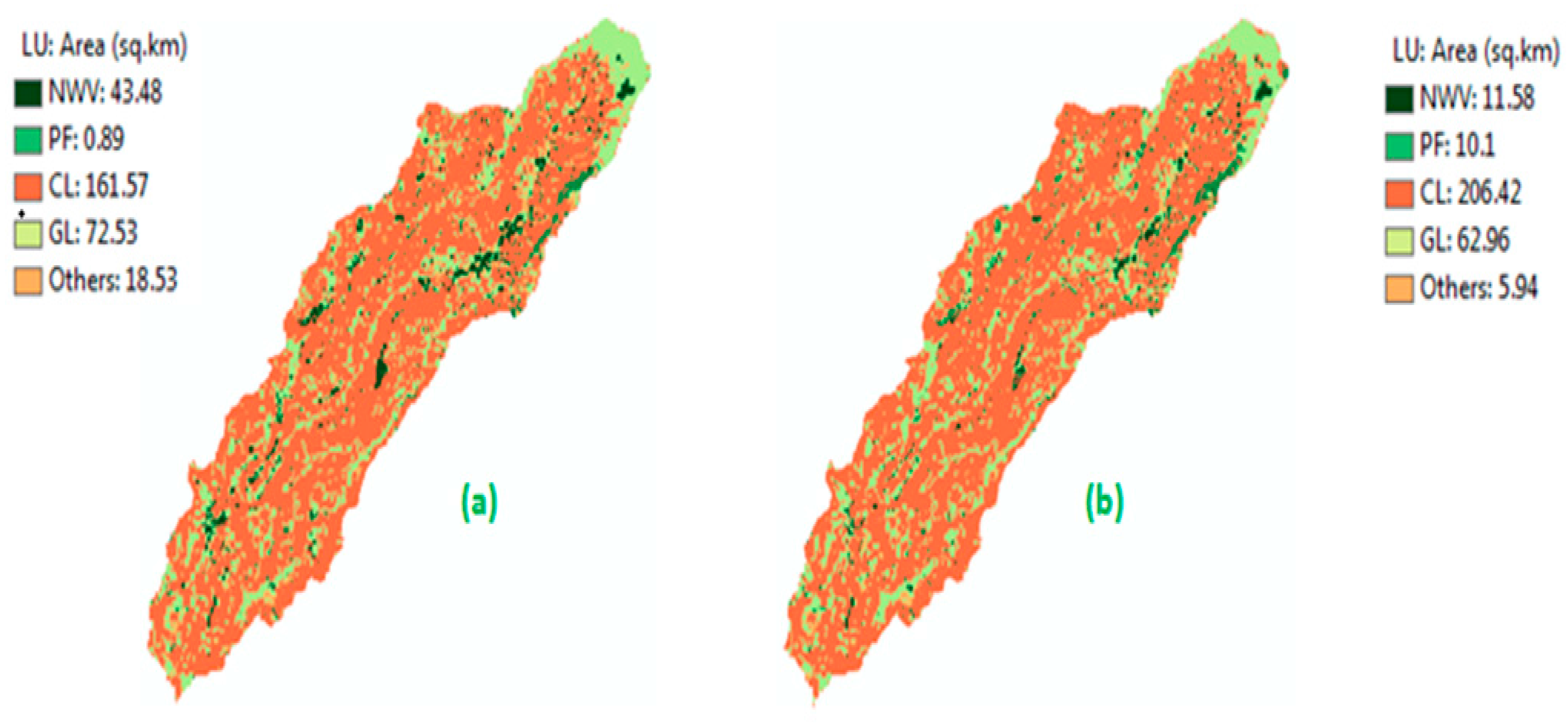
| 1986 | Natural Woody Vegetation | Plantation Forest | Cultivated Land | Grassland | Others | Total 2009 (km2 (%)) | |
|---|---|---|---|---|---|---|---|
| 2009 | |||||||
| Natural Woody Vegetation | 6.59 | 0.00 | 2.38 | 2.05 | 0.56 | 11.58 | |
| (2.22) | (0.00) | (0.80) | (0.69) | (0.19) | (3.90) | ||
| Plantation Forest | 1.40 | 0.89 | 3.77 | 3.86 | 0.18 | 10.1 | |
| (0.47) | (0.30) | (1.27) | (1.30) | (0.06) | (3.40) | ||
| Cultivated Land | 9.50 | 0.00 | 150.58 | 45.07 | 1.27 | 206.42 | |
| (3.20) | (0.00) | (50.70) | (15.18) | (0.42) | (69.50) | ||
| Grassland | 25.84 | 0.00 | 4.51 | 20.87 | 11.74 | 62.96 | |
| (8.70) | (0.00) | (1.52) | (7.02) | (4.00) | (21.20) | ||
| Others | 0.15 | 0.00 | 0.33 | 0.68 | 4.78 | 5.94 | |
| (0.05) | (0.00) | (0.11) | (0.23) | (1.60) | (2.00) | ||
| Total 1986 (km2 (%)) | 43.48 | 0.89 | 161.57 | 72.53 | 18.50 | 297.00 | |
| (14.64) | (0.30) | (54.40) | (24.42) | (6.20) | (100.00) | ||
| Land Use | Pop. | Slope | Elev. | Dist. to Settlement | Dist. To Roads | Dist. to Market | Livestock | Dist. To Water | Dist. to Forest Edge | |
|---|---|---|---|---|---|---|---|---|---|---|
| Variables | ||||||||||
| Natural woody vegetation | −0.23 | −0.60 | 0.03 | 0.08 | 0.04 | −0.01 | 0.02 | 0.02 | 0.84 | |
| Plantation forest | 0.14 | 0.69 | 0.39 | −0.52 | −0.28 | 0.02 | 0.04 | 0.04 | 0.01 | |
| Cultivated land | 0.79 | 0.65 | 0.02 | −0.26 | −0.04 | −0.52 | 0.04 | −0.05 | 0.001 | |
| Grassland | −0.40 | 0.68 | 0.78 | −0.54 | −0.03 | −0.01 | 0.23 | −0.31 | 0.04 | |
| Others | 0.10 | 0.06 | 0.001 | −0.02 | 0.01 | 0.03 | 0.01 | 0.10 | 0.002 | |
| LU-Drivers | Rotated Component Loadings | Communality Estimates | ||||
|---|---|---|---|---|---|---|
| PC1 | PC2 | PC3 | PC4 | PC5 | ||
| Population | 0.887 | −0.227 | 0.418 | −0.147 | 0.281 | 0.946 |
| Distance to market | −0.718 | 0.005 | 0.145 | −0.020 | 0.127 | 0.864 |
| Distance to road | −0.135 | 0.001 | 0.889 | 0.308 | 0.054 | 0.885 |
| Slope | 0.741 | −0.252 | 0.161 | −0.312 | 0.319 | 0.939 |
| Elevation | 0.010 | 0.929 | 0.458 | 0.208 | 0.121 | 0.932 |
| Livestock | 0.320 | 0.721 | 0.120 | 0.089 | 0.073 | 0.786 |
| Distance to settlement | −0.753 | −0.549 | −0.644 | 0.078 | −0.057 | 0.906 |
| Distance to water | −0.247 | 0.114 | 0.324 | 0.096 | 0.895 | 0.917 |
| Soil type | 0.260 | −0.022 | 0.081 | 0.069 | 0.151 | 0.671 |
| Precipitation | 0.253 | 0.001 | 0.059 | 0.066 | 0.173 | 0.681 |
| Distance to forest edge | 0.078 | 0.002 | 0.013 | 0.921 | 0.091 | 0.884 |
| Initial eigenvalues | 3.290 | 1.880 | 1.810 | 1.240 | 1.190 | - |
| Variance (%) | 29.910 | 17.090 | 16.450 | 11.270 | 10.820 | - |
| Cumulative variance (%) | 29.910 | 47.000 | 63.450 | 74.730 | 85.550 | - |
| Land Use | Variable | Suitability Ranges | Initial Weight | Assigned Weight (After Calibration) | Direction of Relationship * |
|---|---|---|---|---|---|
| Natural and Woody Vegetation | Distance to forest edge | >1000 m | 0.35 | 0.50 | Positive |
| Distance to Roads | >5000 m | 0.25 | 0.20 | Positive | |
| Slope | <40% | 0.20 | 0.20 | Negative | |
| Distance to settlement | >3000 m | 0.20 | 0.10 | Positive | |
| Cultivated land | Slope | <20% | 0.40 | 0.66 | - |
| Distance to Settlement | <5000 m | 0.10 | 0.20 | Negative | |
| Distance to market | <10,000 m | 0.20 | 0.10 | Negative | |
| Distance to water | <10,000 m | 0.30 | 0.24 | Negative | |
| Plantation Forest | Slope | 5%–40% | 0.20 | 0.30 | - |
| Elevation | 1200–3400 m | 0.20 | 0.10 | - | |
| Distance to settlement | <5000 m | 0.40 | 0.50 | Negative | |
| Distance to road | <1000 m | 0.20 | 0.10 | Positive | |
| Grassland | Slope | >10% | 0.30 | 0.30 | Positive |
| Elevation | >2600 m.a.s.l. | 0.25 | 0.20 | Positive | |
| Distance to water | <5000 m | 0.25 | 0.30 | Negative | |
| Distance to settlement | <20,000 m | 0.20 | 0.20 | Negative |
| Name of Algorithm | Component | Measure (%) |
|---|---|---|
| Quantity and Allocation Disagreement | Change simulated as “persistence“ (quantity disagreement) | 2.5 |
| Persistence simulated as “change” (quantity disagreement) | 6.2 | |
| Change simulated as “change to wrong category” (allocation disagreement) | 7.3 | |
| Total Disagreement | 16.0 |
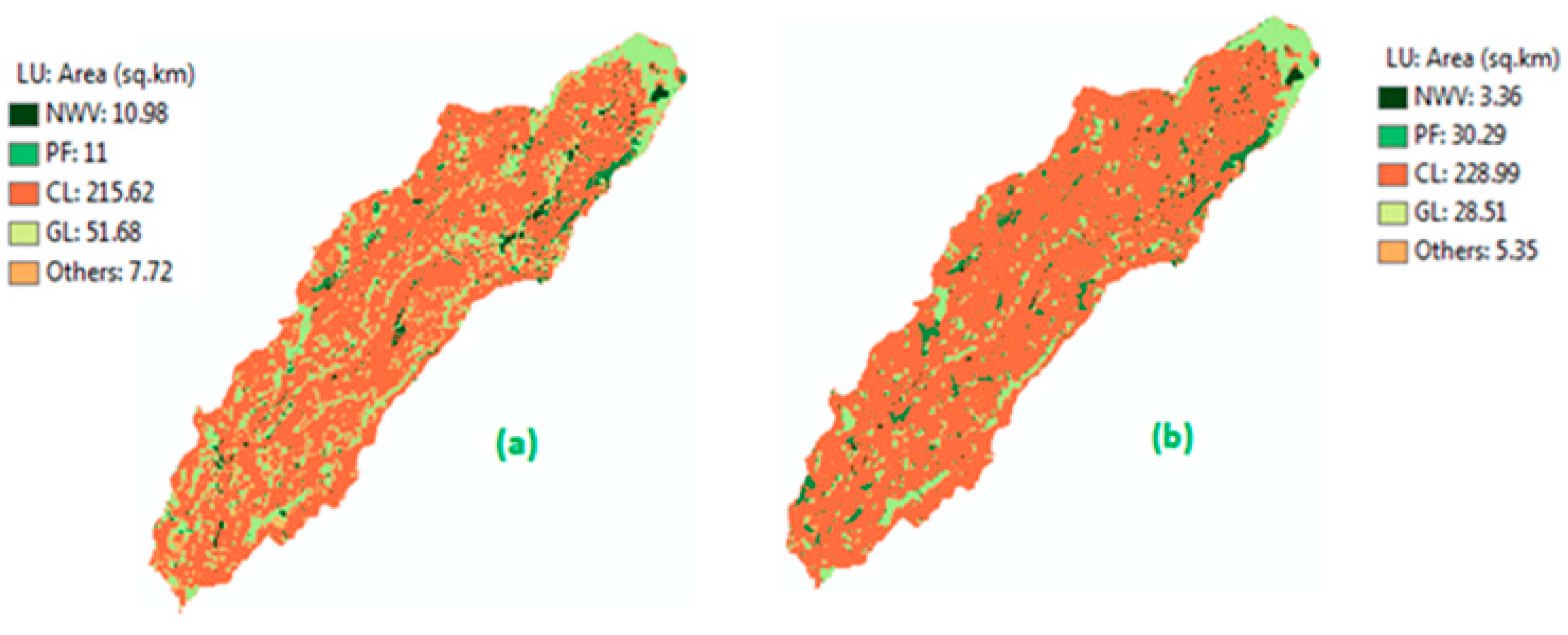
| 2009 | Natural Woody Vegetation | Plantation Forest | Cultivated Land | Grassland | Others | Total 2025 (km2 (%)) | |
|---|---|---|---|---|---|---|---|
| 2025 | |||||||
| Natural Woody Vegetation | 2.90 | 0.10 | 0.23 | 0.10 | 0.10 | 3.40 | |
| (0.98) | (0.03) | (0.08) | (0.03) | (0.03) | (1.15) | ||
| Plantation Forest | 4.00 | 8.60 | 9.39 | 8.02 | 0.31 | 30.30 | |
| (1.35) | (2.90) | (3.16) | (2.7) | (0.10) | (10.20) | ||
| Cultivated land | 1.80 | 0.40 | 196.00 | 28.34 | 2.76 | 229.00 | |
| (0.60) | (0.13) | (66.00) | (9.54) | (0.93) | (77.10) | ||
| Grassland | 2.10 | 0.60 | 0.60 | 24.90 | 0.33 | 28.50 | |
| (0.70) | (0.20) | (0.20) | (8.40) | (0.11) | (9.60) | ||
| Others | 0.78 | 0.40 | 0.20 | 1.60 | 2.44 | 5.40 | |
| (0.26) | (0.13) | (0.07) | (0.50) | (0.82) | (1.82) | ||
| Total 2009 (km2 (%)) | 11.58 | 10.10 | 206.42 | 62.96 | 5.94 | 297.00 | |
| (3.90) | (3.40) | (69.50) | (21.20) | (2.00) | (100.00) | ||
© 2016 by the authors; licensee MDPI, Basel, Switzerland. This article is an open access article distributed under the terms and conditions of the Creative Commons Attribution (CC-BY) license (http://creativecommons.org/licenses/by/4.0/).
Share and Cite
Yalew, S.G.; Mul, M.L.; Van Griensven, A.; Teferi, E.; Priess, J.; Schweitzer, C.; Van Der Zaag, P. Land-Use Change Modelling in the Upper Blue Nile Basin. Environments 2016, 3, 21. https://doi.org/10.3390/environments3030021
Yalew SG, Mul ML, Van Griensven A, Teferi E, Priess J, Schweitzer C, Van Der Zaag P. Land-Use Change Modelling in the Upper Blue Nile Basin. Environments. 2016; 3(3):21. https://doi.org/10.3390/environments3030021
Chicago/Turabian StyleYalew, Seleshi G., Marloes L. Mul, Ann Van Griensven, Ermias Teferi, Joerg Priess, Christian Schweitzer, and Pieter Van Der Zaag. 2016. "Land-Use Change Modelling in the Upper Blue Nile Basin" Environments 3, no. 3: 21. https://doi.org/10.3390/environments3030021