Prospecting Glacial Ages and Paleoclimatic Reconstructions Northeastward of Nevado Coropuna (16° S, 73° W, 6377 m), Arid Tropical Andes

 ,
, 
Abstract
:1. Introduction
- (a)
- Boreal cooling periods, events such as Younger Dryas (YD) and Heinrich (H1... Hn), caused by the Atlantic Meridional Overturning Circulation (AMOC) shutdowns, blocking the inter-hemispheric energy exchange, as a consequence of the marine desalination due to the discharge of icebergs and or freshwater in the North Atlantic.
- (b)
- Greater moister phases than the present in the humid and arid Central Andes.
- -
- On the one hand, the chronology of moraines shows glacial advances contemporary to cold boreal events, both in glaciers of the eastern tropical Central Andes, which are more sensitive to temperature (e.g., Quelccaya ice cap [6]), and in glaciers of the tropical western Central Andes, which are more sensitive to precipitation (e.g., Ampato-Sabancaya-Hualca Hualca [7]), Cerro Tunupa [8] or Uturuncu volcano [9].
- -
- On the other hand, the cold boreal phases have also been chronologically correlated with paleolake transgressions in the Bolivian Altiplano. Blard et al. [10] linked the last big transgressions, Sajsi (~25–19 ka), Tauca (~18–14 ka), and Coipasa (~13–11 ka), to the Younger Dryas (YD) and Heinrich 1 (H1) events. Placzek et al. [11] identified 10 transgressions over the last ~130 ka, contemporary to colder temperatures and iceberg discharges in the North Atlantic. Therefore, the boreal cooling/Andean-moisture-increase teleconnection may have occurred many times throughout the last glacial cycle and even in previous Pleistocene glacial cycles. The ITCZ southward shift have been detected in scales of hundreds [12] to tens of thousands of years [13]. There are many examples: speleothems [14,15], ice cores [16], or marine sediments [17,18].
- (a)
- Taken together, there are 36Cl ages from moraine boulders [7] showing glaciers in maximum extension ~19–14 ka ago, northward and eastward of the Hualca Hualca volcano. Furthermore, there are 36Cl ages from polished bedrocks, which mark the beginning of the deglaciation, between ~13–11 ka ago in Patapampa Altiplano sites (4950 m) isolated from the surrounding summits, and between ~14–9 ka ago in the lower Pujro Huayjo valley, where glaciers descend from the peaks (>5800 m).
- (b)
- Nonetheless, the 3He chronology suggests an earlier deglaciation at northeastern Coropuna, in valleys whose summits are >6000 m in altitude. There are moraine boulder ages showing glaciers in maximum extension ~26–15 ka ago [38] and shorter and higher glacial advances in the same valleys ~14–10 ka ago [47].
2. Study Area
2.1. Volcanic Settings
2.2. Climatic Settings
- -
- Quercus and Podocarpus: from the Amazon basin, ~300 km northeastward.
- -
- Nothofagus: native of Patagonia, >3000 km toward the south.
- -
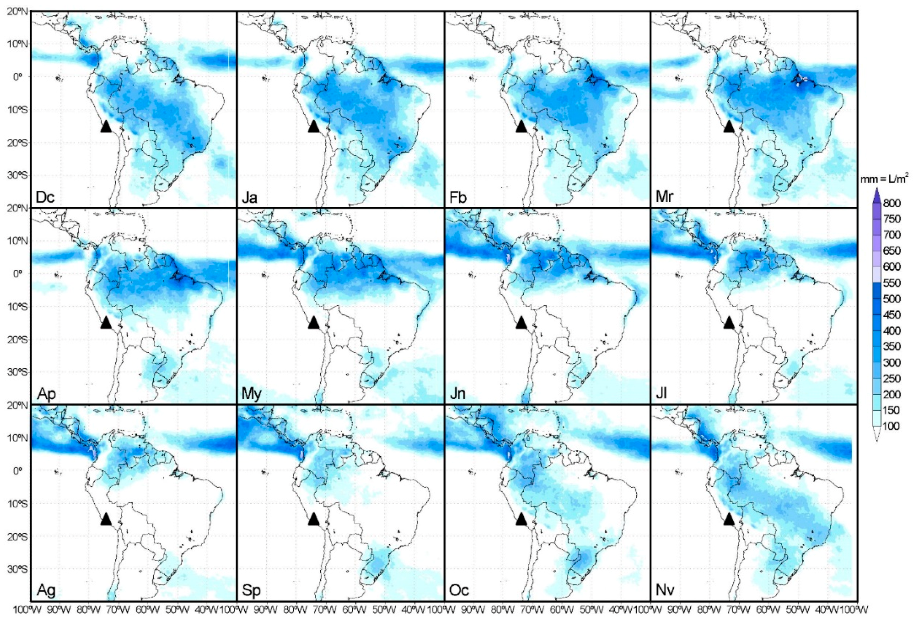
- 70–90% of the precipitation take place in the austral summer (December-March), coinciding with the ITCZ southward deflection and the winter in the Northern Hemisphere.
- -
- The precipitation decreased during two El Niño-Southern Oscillation (ENSO) events, in 1982–1983 and 1992, but not in the ENSO 1997–1998.
2.3. Glacial Settings
2.3.1. Glacier Surfaces
2.3.2. Snowlines, ELAs and Glacial Dating
- -
- CI moraines: ~25–15 ka (Lm) and ~21–12 ka (Li), with outlier ages ~47 and ~31 ka (Li) and ~61 and ~37 ka (Lm).
- -
- CII moraines: ~11–12 ka (Lm) and ~11–8 ka (Li).
- -
- PaleoELA MELM (Maximum Elevation of Lateral Moraines): 5167 ± 59 m.
- -
- PaleoELAs THAR: 5116 ± 91 m (THAR = 0.25); 5116 ± 89 m (THAR = 0.28) and 5200 ± 88 m (THAR = 0.30); with 5144 ± 89 m average.
3. Methods
3.1. Exposure Ages
3.1.1. Geomorphological Mapping and Fieldwork
3.1.2. Labwork
- (a)
- Major elements: by inductively coupled plasma optical emission spectrometry (ICP-OES).
- (b)
- Trace elements: by inductively coupled plasma mass spectrometry (ICP-MS).
- (c)
- Boron: by prompt-gamma neutron activation analysis (PGNAA).
3.2. ELA and PaleoELA Reconstruction
- (a)
- PaleoELA1 (CI phase): maximum glacier advance within the valleys connected to the highest Coropuna peaks (>5200 m).
- (b)
- PaleoELA2 (pre-CI phase): maximum glacier advance, covering the whole of the Altiplano and reaching even lower valleys towards the northeast and east of the Coropuna.
3.3. Paleoclimate Reconstructions
3.3.1. Paleoclimate Cooling
3.3.2. Paleoprecipitation
- -
- ELA (m): Equilibrium Line Altitude by the AABR method in the year analyzed (ELA2010).
- -
- Fz (m): Annual average freezing-altitude.
- -
- P (mm): Total annual precipitation at the ELA.
- -
- Fz (m): annual average freezing-altitude (Fz2010 = 5589 m), calculated from the 1 January 2010–31 December 2010 data recorded by CRYOPERU thermometers in the CORNE11 (4886 m) and CORNE41 (5822 m) stations. In this calculation, the ATLREARTH = 6.5 °C/km gradient was applied.
- -
- -
- P (mm): Paleoprecipitation in the time of maximum paleoELA depression (equivalent to maximum glacier extension).
- -
- Fc = 635 (as explained previously).
- -
- Fz (m) is the annual average freezing-altitude estimated for the past, which was obtained by subtracting the ΔT (°C), deducted in Equation (1), to the air temperature annual mean (°C) in the CORNE4 station.
- -
- PaleoELA (m) is the ELA AABR in the maximum glacier extension (PaleoELA2 in the pre-CI phase).
4. Results
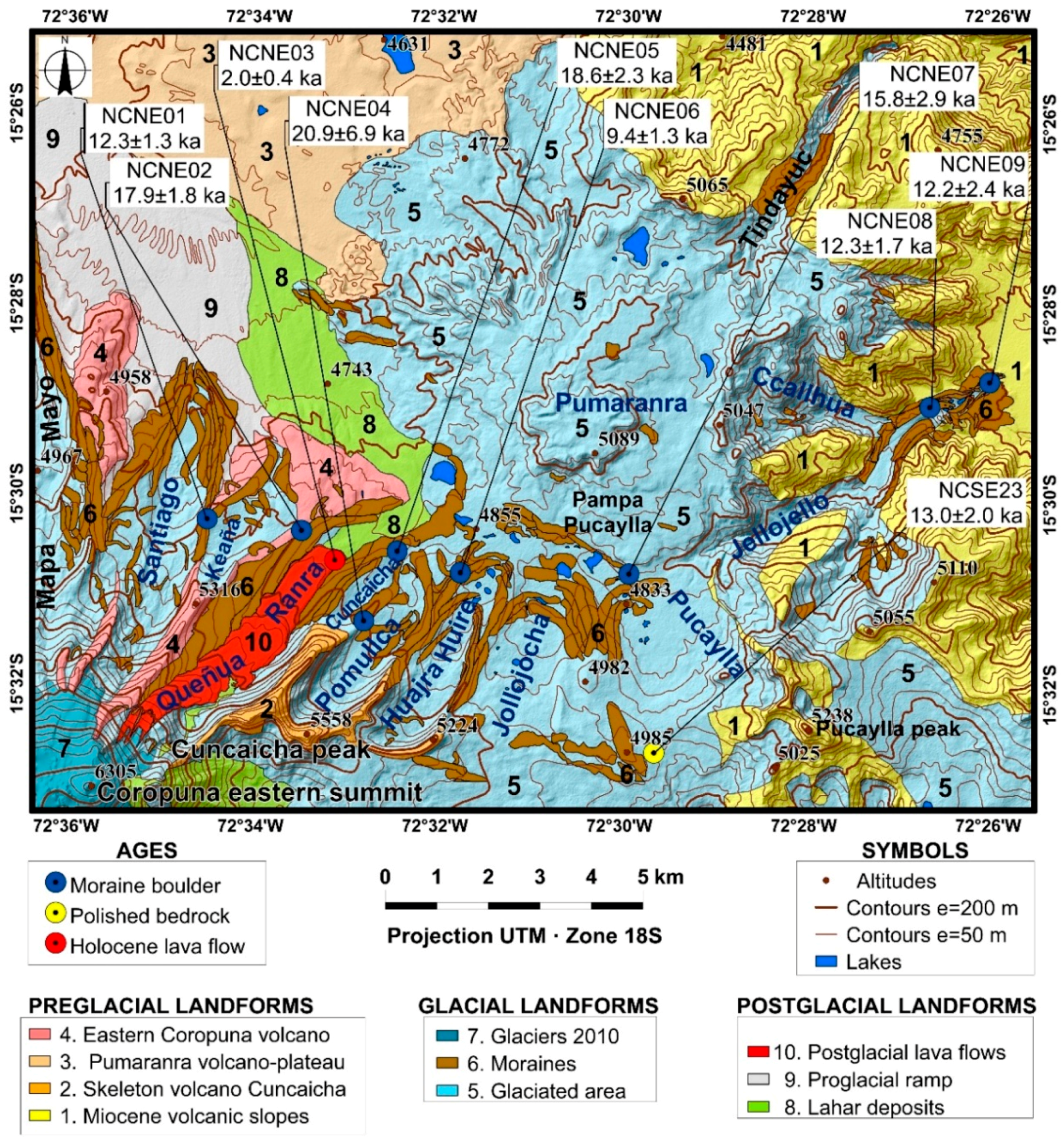
4.1. Geomorphological Map
4.1.1. Preglacial Landforms
- (1)
- Miocene volcanic slopes (<5100 m): pre-Quaternary hillsides [90] non-eroded by glaciers connecting topographically the South American Altiplano surrounding the current Coropuna and the bottom of the deepest valleys located at the east and the south of the mapped area.
- (2)
- Volcano-skeleton Cuncaicha (5558 m): A hydrothermalized volcanic structure, strongly eroded by glaciers, adjacent to Coropuna.
- (3)
- Pumaranra volcano-plateau (5089 m): small flattened summit, only ~100 m higher than the Altiplano, and lava flows scattered around this emission center.
- (4)
- Eastern Nevado Coropuna (>6000 m): highest and youngest stratovolcanoes, whose summits are currently completely glacier covered.
4.1.2. Glacial Landforms
- -
- Northward of the Coropuna eastern summit (6305 m) and the Cuncaicha peak (5558 m): the Mapa Mayo, Santiago, Keaña, Queñua Ranra, Cuncaicha, Pommullca and Huajra Huire valleys.
- -
- Pampa Pucaylla Altiplano, a little endorheic basin where ice tongues arrived from slightly higher surrounding areas: Cerro Pumaranra (northward); Pucaylla Peak (toward southeast) and the watershed-splitting linking the eastern Cuncaicha Peak foothills and the western flank of Pucaylla Peak.
- -
- Tindayuc, Callhua and Jellojello Valleys, which channeled the past glacier advances, overflowing the Pampa Pucaylla northeast and east limits and going down towards the Valle de los Volcanes.
4.1.3. Postglacial Landforms
- -
- Proglacial ramp (9) covered by ash, lapilli, and volcanic bombs.
- -
- Postglacial lava flow (10) and lahar deposits (8) in the Queñua Ranra valley.
4.2. Geomorphological Analysis and 36Cl Ages
4.2.1. Coropuna Northeast Slope
- (a)
- Santiago Valley
- (b)
- Keaña Valley
- (c)
- Queñua Ranra Valley
4.2.2. Cuncaicha Peak North Face
- (a)
- Cuncaicha Valley
- (b)
- Pomullca Valley
- (c)
- Huajra Huire Valley
4.2.3. Glacier Source Areas that Flowed into the Pampa Pucaylla Altiplano
- (a)
- Jollojocha Valley
- -
- The western area is the outer face of the Huajra Huire Valley headwater, eastward of the 5224 m peak.
- -
- The eastern area is ~2 km toward the east, at around 4985 m.
- (b)
- Pucaylla Valley
- -
- The western area has a lower, reaching 4985 m in altitude in the line dividing the northeastern and southeastern Coropuna drainage basins (Figure 7).
- -
- The eastern area is higher (~5200 m). It is on the Pucaylla Peak northwest face (5238 m).
- (c)
- Pumaranra volcano-plateau
- -
- South: the Pumaranra glaciers roved only ~1 km and deposited terminal moraines leaning on the moraines of the Queñua Ranra, Pomullca, Huajra Huire, Jollojocha, and Pucaylla Valleys.
- -
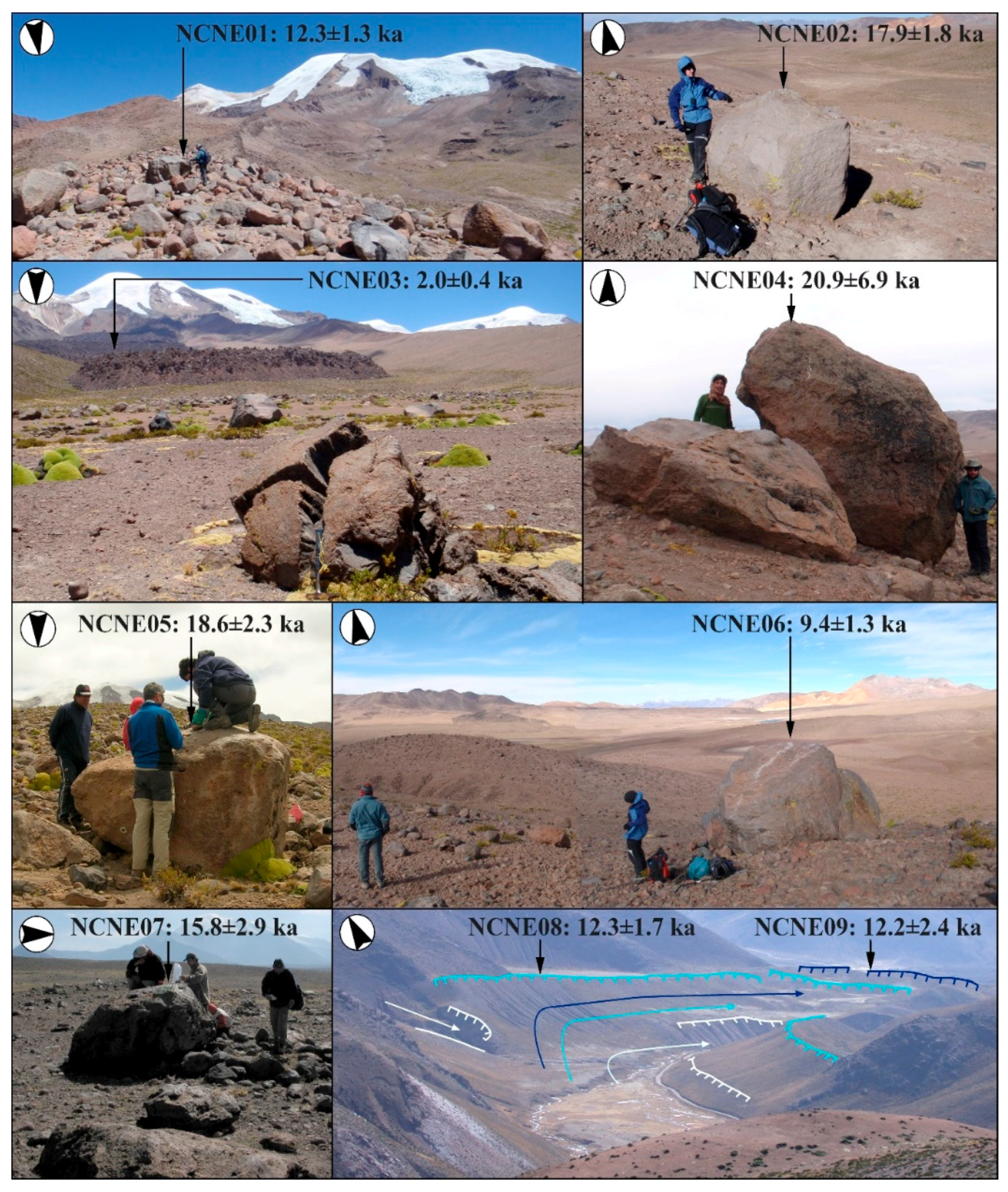
- Southeast: the Pumaranra glaciers converged with others descending from the Pucaylla peak north face. This confluence gave rise to a larger glacier, which was channeled within the Jellojello Valley, depositing at least four generations of lateral and terminal moraines, at ~4200 m in altitude, ~3–4 km away from the glaciers confluence, and ~6–8 km from the Puchalla Peak and the Pumaranra volcano-plateau. In the Jellojello Valley moraines, the surfaces of two boulders (samples NCNE08 and NCNE09) were sampled. Their absolute dating suggests, respectively, maximum advances (or glacial standstill) of 12.3 ± 1.7 ka and 12.2 ± 2.4 ka ago.
- -
- East: the Pumaranra glaciers overflowed the Pampa Pucaylla Altiplano east boundary, a north-south alignment of summits between ~5050 and ~5000 m in altitude. Once over this obstacle, the ice tongues descended through the Ccallhua Valley to where it meets the Jellojello Valley. Here a terminal moraine was embedded by Ccallhua glaciers in the Jellojello Valley lateral moraines (Figure 4), at ~4300 m altitude and ~6 km away from Punmaranra volcano-plateau.
- -
- Northwest and west: well-defined moraines are not conserved, or are too small to be observed by remote sensing and/or mapped in our work scale. However, the glaciated area can be clearly identified in aerial photographs and satellite images, through changes in the surface appearance due to glacial erosion.
4.2.4. Altiplano Areas Topographically Isolated from the Surrounding Mountains
4.3. ELA, PaleoELAs, Climate Cooling and Paleoprecipitation
- (a)
- PaleoELA1 = 5078 m: glaciers in maximum extension, from the highest mountains (eastern Coropuna summit and Cuncaicha Peak).
- (b)
- PaleoELA2 = 4993 m: all mapped glaciers in maximum extension.
- (a)
- By analyzing the highest paleoglaciers (paleoELA1 = 5078 m) we obtained: the paleoELA depression ΔELA1 = −906 m and the climate cooling ΔT1A = −5.9 °C, using the ATLREARTH = 6.5 °C/km and ΔT1B = −6.4 °C, applying the current gradient ATLR2010 = 7.0 °C/km.
- (b)
- Through the analysis of all the paleoglaciers of the study area (paleoELA2 = 4993 m), we estimated the paleoELA depression ΔELA1 = −991 m and the climate cooling ΔT2A = −6.4 °C, using the mean gradient ATLREARTH = 6.5 °C/km and ΔT2B = −6.9 °C and the current gradient ATLR2010 = 7.0 °C/km.
- (a)
- Assuming a value similar to the current ATLR2010 = 7.0 °C/km, a paleoprecipitation P6080m = 669 mm was calculated (15% or ×1.2 higher than at present).
- (b)
- By applying the Earth mean value (ATLREARTH = 6.5 °C/km) a paleoprecipitation P6080m = 1628 mm was estimated to be 181% or ×2.8 higher than at present.
5. Discussion
5.1. ELA, PaleoELA and Paleoclimate Reconstructions
5.1.1. ELA2010
- -
- Both works used the elevation model of the national topographic map of Peru (IGN, scale 1: 50,000 and 50 m between contour lines), based on aerial photographs from 1955.
- -
- We have developed a reliable model, combining a 2010 satellite image with the contour lines, to apply the AABR method for the ELA and paleoELA reconstructions.
- -
- Bromley et al. [47] calculated the ELA2010 adding to the kinematic ELA1955, understood as the inflection from convex (ablation zone) to concave (accumulation zone) on the glacier surface contours (e.g., [91,92,93,94]), an assumed ELA1955–2010 rise (m), deduced from three variables: Time elapsed from 1955 to 2010 (55 years); Air temperature warming in the Andes: 0.1 °C/decade [95] and the ATLR = 6.58 °C/km.
5.1.2. PaleoELA
5.1.3. PaleoELA Depression
5.1.4. Paleoclimate Reconstructions
5.2. Geomorphological and Exposure Ages Interpretation
5.2.1. The Glaciers Maximum Extension and the Polygenic Moraines Deposition
- (a)
- The high altitude of the stratovolcanoes (>6000 m) and the Altiplano (~4900–4700 m).
- (b)
- The paleoELA depression very close to the Altiplano level (paleoELA2 = 4993 m).
- (c)
- The role of the Altiplano surrounding the mountains, behaving as a topographical obstacle to glacial advances.
- (d)
- The greater sensitivity of glaciers to precipitation than temperature [4].
- (e)
- The moister and colder paleoclimate than the present.
- -
- Eastern lateral moraine in Santiago Valley: sample NCNE01 (~14–11 ka).
- -
- Eastern lateral moraine in Queñua Ranra Valley: sample NCNE02 (~20–16 ka).
- -
- Western lateral moraine and terminal moraine in Pomullca valley: samples NCNE04 (~28–14 ka) and NCNE05 (~21–16 ka).
- -
- Terminal moraine deposited in Pampa Pucaylla Altiplano by paleoglaciers from the Pumaranra volcano-plateau: sample NCNE05 (~21–16 ka).
5.2.2. The Deglaciation Onset in the Nevado Coropuna and Its Surroundings
- (a)
- The sampled surfaces rejuvenation by erosion (NCNE08 and NCNE09). It is a feasible hypothesis, although the preservation of abundant polished bedrocks on the Nevado Coropuna southern and western slopes [51] suggests that erosion rates may have been very low.
- (b)
- The volcanic activity and geothermal heat’s influence on deglaciation. This is also possible, as indicated by the following facts:
- -
- West, southeast and northeast of the Coropuna summits, three clearly postglacial lava flows (Figure 1), the last one only 2 ka ago (sample NCNE03), are evidence that Coropuna is not an extinct volcano.
- -
- -
- Regardless of the altitude, if the distribution of ground temperature was also unequal in the past, it could have caused the deglaciation of some places, while at other sites glacial advances could occur.
- (c)
- The paleoELA reconstructions show accumulation areas in the Jellojello and Ccallhua Valleys headwaters (Figure 7), whether they are calculated considering only the glaciers coming from the highest mountains (paleoELA1 = 5078 m), or if they are estimated for all the mapped ice masses (paleoELA2 = 4993 m).
- -
- The NCNE01 sample seems to indicate a maximum advance in the Santiago Valley 13.6–11.0 ka ago.
- -
- In the Jellojello Valley there are moraines even younger than those dating from 14.6 to 9.8 ka, according to the NCNE08 and NCNE09 ages.
- -
- The NCNE06 sample suggests that, 10.7–8.1 ka ago, a glacier existed that only reached the middle part of the Huajra Huire valley, which indicates that by that time the deglaciation had already begun and was quite significant (Figure 4).
- -
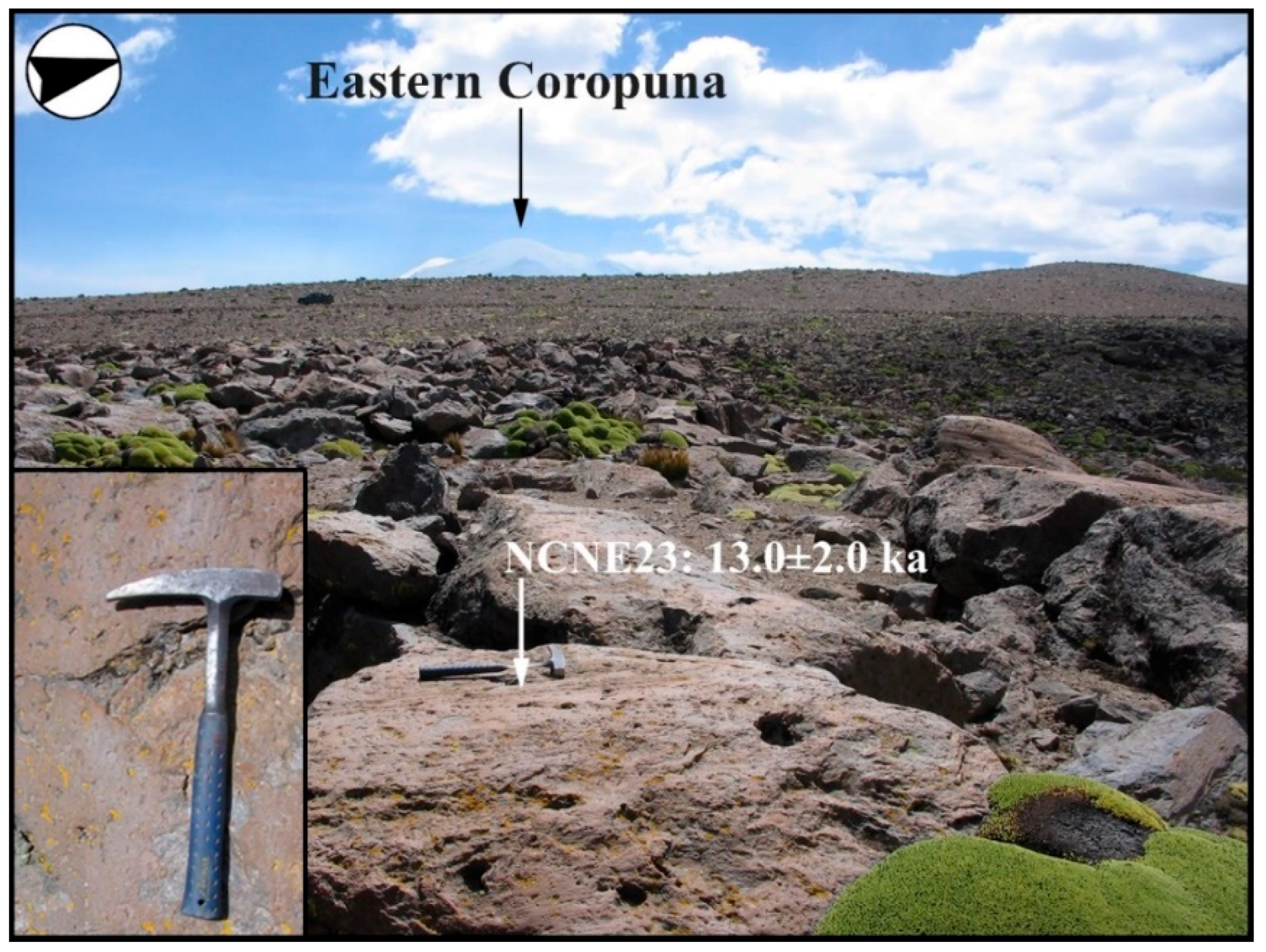
- On the Altiplano, ~20 km eastward of the Hualca Hualca stratovolcano, the Patapampa 4 sample (a polished bedrock) suggests that, in the lowest places, topographically isolated from the surrounding peaks, the melting could have begun 12.9–10.9 ka ago.
- -
- Although there is some uncertainty due to the error ranges, the sample comes from a similar geomorphological framework, an Altiplano site at 4886 m in altitude cut off from higher mountains, and the chronology is quite consistent with our NCSE23 age (13.0 ± 2.0 ka).
- -
- The Pujro Huayjo 2 was collected from another polished bedrock, at low altitude (4450 m) but coming from a higher source area, the Hualca Hualca summit (~5800 m). Despite that, the age (13.9–9.1 ka) is not absolutely incompatible with the Patapampa 4 and our Coropuna ages (like NCSE23).
5.3. Paleoclimatic Framework
- (a)
- First, between ~19 and ~9 ka, the Surface Sea Temperature (SST) westward of the Iberian Peninsula (SSTN; [109]) got warmer by 6 °C in 10 ka. However, it was not a gradual trend, because it was broken by abrupt cold episodes due to AMOC shutdowns: H1 (e.g., [110,111]) and YD (e.g., [112]), which appear reflected in the SSTN curve, ~18 and ~12 ka ago, respectively.
- (b)
- Secondly, the humidity increases due to cold boreal events, which is well recorded in the Andean Altiplano lacustrine evidence; e.g.,
- -
- At the Coropuna latitude (~16° S), one clear evidence of moister conditions is the strong decrease in the Titicaca salinity ~21–10 ka ago, as shown by the great abundance (>80%) of freshwater plankton, nowadays extinct, in the lake sediments [113].
- -
- Southward (17–22° S), in the lake transgressions Sajsi (~25–19 ka); Tauca (~18–14 ka) and Coipasa (~11–13 ka; [10]). The wettest climate was at the Tauca highstand (17.0–15.7 ka). The maximum water depth of 120 m was registered in the center of the Uyuni basin, for a total lake surface of about 52.000 km2 [8,10,114,115].
- (a)
- The mountain altitude determines which areas can be higher and colder than the isotherm of air temperature of 0 °C, transforming into places where:
- -
- Precipitation is exclusively solid (as it still happens nowadays in Coropuna) and do not negatively influence the glaciers mass balance.
- -
- The snow is preserved and transformed into glacier ice, feeding a positive mass balance.
- (b)
- The mountains latitude is also key, due to the climate dryness trend to increase westward and southward of the Central Andes, and the ELA rise in the same direction, because of the aridity [25]. As an outcome of this trend, southern of the South American Arid Diagonal, there are currently no glaciers in mountains as high as Uturuncu volcano (~22° S, 6009 m) or Nevado Ojos del Salado (~27° S, 6893 m).
5.4. The Last Glacial Maximum and Deglaciation in the Arid Tropical Andes
- -
- In Uturuncu (~22° S) the glaciers retreated higher than 5094–5111 m in altitude, ~16.1–13.7 ka ago (polished bedrock ages for UTU-1A, UTU-1B and UTU-1C). Given that the glacial shrinkage was synchronous to the Bølling-Allerød (B/A) boreal warming, it could reflect a mixed influence of the regional temperature increase, together with the abrupt oscillations of late Pleistocene precipitation, at the rate of the North Atlantic events [9].
- -
- In Cerro Tunupa (~20° S), there was also a fast deglaciation, after the Tauca highstand and contemporaneous with the B/A boreal warming. Despite the lower Tunupa altitude (~5400 m), compared to Uturuncu (6009 m), it seems that the greater closeness of tropical circulation (Tunupa is ~280 km northward of Uturuncu) enabled a small glacier pulse, ~13.6–11.8 ka ago (moraine ages TU-3A and TU-3B), during the paleolake Coipasa transgression (Figure 12) and the boreal YD, and before the complete Tunupa deglaciation, after ~12 ka [9].
- -
- The last glacier pulse in Tunupa seems synchronous with our observations eastward of Coropuna ~14.6–9.8 ka (moraine ages for NCNE08 and NCNE09), when glaciers overflowed the Pampa Pucaylla Altiplano and went down the Ccallhua and Jellojello Valleys. In both cases (Tunupa and Pampa Pucaylla) the glaciers came from the same summit altitude (~5100 m), which point out that our reconstructions in Coropuna (Figure 11) are a regional paleoELA good estimate (~5078–4993 m).
- -
- The divergences in magnitude (maximum advances in Coropuna and small late pulse in Tunupa) could be due to the differences in latitude and altitude, because Coropuna is higher and further to the North and Tunupa’s lower and further to the South, so there is another possibility: the boreal warming B/A would have weakened the tropical circulation, retracting its influence area towards a lower latitude. This way would explain why they occurred simultaneously: great freshwater plankton abundance (90%) in Lake Titicaca sediments [113]; Figure 12), long glacial standstill episodes in the Ccallhua and Jellojello valleys, lower than the altiplano (this work), both at ~16° S, and the glacier pulse in Tunupa, smaller and closer to the summit [8], at ~20° S.
- -
- On Patapampa and Pucaylla, the glaciers disappear in lower sites (~4900 m), topographically isolated from higher peaks.
- -
- In Patohko, glaciers linked to the summit area of Sajama (6542 m) retreated up the slope from the middle valley (4692–4712 m).
6. Conclusions
- -
- A 36Cl glacial ages survey and a paleoclimatic reconstruction based on the geomorphological evidence of the glaciers past evolution has been achieved on Nevado Coropuna. The results have been compared to information of the same type obtained by previous works in other Andean mountains, as well as to other present and past evidences on the regional climate and its global teleconnections.
- -
- According to our data set interpretation, the Nevado Coropuna glacier system may have been near or in maximum expansion along the MIS2, MIS3, and MIS4 marine isotope stages and even earlier. During this timespan, it is possible that many glacial advances occurred, which reached the same extent as a result of the damming effect of pre-existing moraines and the role of the Altiplano as a topographic barrier. It is also possible that the glaciers had been in a steady state close to their maximum extension for a long time. Any of the two possibilities (multiple large advances and/or long glacial standstill) could explain, jointly or separately, that nowadays we find polygenic moraines, which can include a wide range of exposure ages. The polygenic moraines diachronic deposition can also explain the glacial ages dispersion in other Tropical Andes mountains.
- -
- The Coropuna and other mountains glacial ages indicate more humid climate conditions than the currently Arid Tropical Andes, possibly linked to the Northern Hemisphere cooling episodes via the tropical circulation southward shift. The relational boreal cooling-tropical humidity-Andean glaciers extension may have happened along the last glacial cycle and also in previous glacial cycles. Likewise, it must be the cause of the conservation, in the Coropuna and other mountains, of great advances (or glacial standstill) after the LGM ended and until the last lake transgressions in the Bolivian Altiplano.
- -
- The increased aridity demonstrated by the ELA trend south of the region indicates that the mountains latitude and altitude must have a very important role in the glaciers evolution on the Arid Tropical Andes, modulating the glacial response to changes in tropical circulation and boreal cooling. For this reason, the last regional deglaciation seems to have been earlier in the southernmost, driest, and/or lower mountains and more belated in the northernmost, less arid and higher mountains.
Author Contributions
Acknowledgments
Conflicts of Interest
References
- Kaser, G.; Osmaston, H. Tropical Glaciers; Cambridge University Press: Cambridge, UK, 2002; p. 207. [Google Scholar]
- Rupper, S.; Roe, G.; Gillespie, A. Spatial patterns of Holocene glacier advance and retreat in Central Asia. Quat. Res. 2009, 72, 337–346. [Google Scholar] [CrossRef]
- Rupper, S.; Roe, G. Glacier changes and regional climate: A mass and energy balance approach. J. Clim. 2008, 21, 5384–5401. [Google Scholar] [CrossRef]
- Sagredo, E.A.; Rupper, S.; Lowell, T.V. Sensitivities of the equilibrium line altitude to temperature and precipitation changes along the Andes. Quat. Res. 2014, 81, 355–366. [Google Scholar] [CrossRef]
- Sagredo, E.; Lowell, T. Climatology of Andean glaciers: A framework to understand glacier response to climate change. Glob. Planet. Chang. 2012, 86–87, 101–109. [Google Scholar] [CrossRef]
- Kelly, M.A.; Lowell, T.V.; Applegate, P.J.; Smith, C.A.; Phillips, F.M.; Hudson, M.A. Late glacial fluctuations of Quelccaya Ice Cap, southeastern Peru. Geology 2012, 40, 991–994. [Google Scholar] [CrossRef]
- Alcalá-Reygosa, J.; Palacios, D.; Vázquez-Selem, J. A preliminary investigation of the timing of the local last glacial maximum and deglaciation on HualcaHualca volcano-Patapampa Altiplano (arid Central Andes, Peru). Quat. Int. 2017, 449, 149–160. [Google Scholar] [CrossRef]
- Blard, P.-H.; Lavé, J.; Farley, K.A.; Fornari, M.; Jiménez, N.; Ramirez, V. Late local glacial maximum in the Central Altiplano triggered by cold and locally-wet conditions during the paleolake Tauca episode (17–15 ka, Heinrich 1). Quat. Sci. Rev. 2009, 28, 3414–3427. [Google Scholar] [CrossRef]
- Blard, P.-H.; Lavé, J.; Farley, K.A.; Ramírez, V.; Jiménez, N.; Martin, L.C.P.; Charreau, J.; Tibari, B.; Fornari, M. Progressive glacial retreat in the Southern Altiplano (Uturuncu volcano, 22° S) between 65 and 14 ka constrained by cosmogenic 3He dating. Quat. Res. 2014, 82, 209–221. [Google Scholar] [CrossRef]
- Blard, P.-H.; Sylvestre, F.; Tripati, A.K.; Claude, C.; Causse, C.; Coudraing, A.; Condom, T.; Seidel, J.-L.; Vimeux, F.; Moreau, C.; et al. Lake highstands on the Altiplano (Tropical Andes) contemporaneous with Heinrich 1 and the Younger Dryas: New insights from 14C, U-Th dating and d18O of carbonates. Quat. Sci. Rev. 2011, 30, 3973–3989. [Google Scholar] [CrossRef]
- Placzek, C.J.; Quade, J.; Patchett, P.J. A 130 ka reconstruction of rainfall on the Bolivian Altiplano. Earth Planet. Sci. Lett. 2013, 363, 97–108. [Google Scholar] [CrossRef]
- Sachs, J.P.; Sachse, D.; Smittenberg, R.H.; Zhang, Z.; Battisti, D.S.; Golubic, S. Southward movement of the Pacific intertropical convergence zone AD 1400–1850. Nat. Geosci. 2009, 554, 1–7. [Google Scholar] [CrossRef]
- Schneider, T.; Bischoff, T.; Haug, G.H. Migrations and dynamics of the intertropical convergence zone. Nature 2014, 513, 45–53. [Google Scholar] [CrossRef] [PubMed]
- Wang, X.; Auler, A.S.; Edwards, R.L.; Cheng, H.; Cristalli, P.S.; Smart, P.L.; Richards, D.A.; Shen, C.-C. Wet periods in northeastern Brazil over the past 210 kyr linked to distant climate anomalies. Nature 2004, 432, 740–743. [Google Scholar] [CrossRef] [PubMed]
- Apaéstegui, J.; Cruz, F.W.; Vuille, M.; Fohlmeistere, J.; Espinoza, J.C.; Sifeddineg, A.; Strikish, N.; Guyot, J.L.; Ventura, R.; Chengk, H.; et al. Precipitation changes over the eastern Bolivian Andes inferred from speleothem (δ18O) records for the last 1400 years. Earth Planet. Sci. Lett. 2018, 494, 124–134. [Google Scholar] [CrossRef]
- Thompson, L.G.; Mosley-Thompson, E.; Henderson, K.A. Ice-core palaeoclimate records in tropical South America since the Last Glacial Maximum. J. Quat. Sci. 2000, 15, 377–394. [Google Scholar] [CrossRef] [Green Version]
- Peterson, L.C.; Haug, G.H.; Hughen, K.A.; Röhl, U. Rapid Changes in the Hydrologic Cycle of the Tropical Atlantic During the Last Glacial. Science 2001, 290, 1947–1951. [Google Scholar] [CrossRef]
- Haug, G.H.; Hughen, K.A.; Sigman, D.M.; Peterson, L.C.; Röhl, U. Southward Migration of the ITCZ Through the Holocene. Science 2001, 293, 1304–1308. [Google Scholar] [CrossRef] [PubMed]
- Wanner, H.; Beer, J.; Bütikofer, J.; Crowley, T.J.; Cubasch, U.; Flückiger, J.; Goosse, H.; Grosjean, M.; Joos, F.; Kaplan, J.O.; et al. Mid- to Late Holocene climate change: An overview. Quat. Sci. Rev. 2008, 27, 1791–1828. [Google Scholar] [CrossRef]
- Chiang, J.C.H.; Bitz, C.M. Influence of high latitude ice cover on the marine Intertropical Convergence Zone. Clim. Dyn. 2005, 25, 477–496. [Google Scholar] [CrossRef]
- Zhang, R.; Delworth, T.L. Simulated tropical response to a substantial weakening of the Atlantic thermohaline circulation. J. Clim. 2005, 18, 1853–1860. [Google Scholar] [CrossRef]
- Broccoli, A.J.; Dahl, K.A.; Stouffer, R.J. Response of the ITCZ to Northern Hemisphere cooling. Geophys. Res. Lett. 2006, 33, 1–4. [Google Scholar] [CrossRef]
- Chiang, J.C.H.; Biasutti, M.; Battisti, D.S. Sensitivity of the Atlantic Intertropical Convergence Zone to Last Glacial Maximum boundary conditions. Palaeogeography 2003, 18, 1–18. [Google Scholar] [CrossRef]
- Chiang, J.C.H.; Friedman, A.R. Extratropical cooling, interhemispheric thermal gradients, and tropical climate change. Annu. Rev. Earth Planet. Sci. 2012, 40, 383–412. [Google Scholar] [CrossRef]
- Clapperton, C. Quaternary Geology and Geomorphology of South America; Elsevier: Amsterdam, The Netherlands, 1993; p. 769. [Google Scholar]
- Balco, G. Contributions and unrealized potential contributions of cosmogenic-nuclide exposure dating to glacier chronology, 1990–2010. Quat. Sci. Rev. 2011, 30, 3–27. [Google Scholar] [CrossRef]
- Mark, B.; Stansell, N.; Zeballos, G. The Last Deglaciation of Peru and Bolivia. Cuadernos de Investigación Geográfica 2017, 43, 591–628. [Google Scholar] [CrossRef]
- Smith, J.A.; Seltzer, G.O.; Farber, D.L.; Rodbell, D.T.; Finkel, R.C. Early Local Last Glacial Maximum in the Tropical Andes. Science 2005, 308, 678–681. [Google Scholar] [CrossRef] [PubMed] [Green Version]
- Farber, D.L.; Hancock, G.S.; Finkel, R.C.; Rodbell, D.T. The age and extent of tropical alpine glaciation in the Cordillera Blanca, Peru. J. Quat. Sci. 2005, 20, 759–776. [Google Scholar] [CrossRef]
- Phillips, F.M.; Plummer, M.A. CHLOE: A program for interpreting in-situ cosmogenic nuclide dating and erosion studies (abs). Radiocarbon 1996, 38, 98. [Google Scholar]
- Balco, G.; Stone, J.O.; Lifton, N.A.; Dunai, T.J. A complete and easily accessible means of calculating surface exposure ages or erosion rates from 10Be and 26Al measurements. Quat. Geochronol. 2008, 3, 174–195. [Google Scholar] [CrossRef]
- Marrero, S.M.; Phillips, F.M.; Borchers, B.; Lifton, N.; Aumer, R.; Balco, G. Cosmogenic nuclide systematics and the CRONUScalc program. Quat. Geochronol. 2016, 31, 160–187. [Google Scholar] [CrossRef] [Green Version]
- Marrero, S.; Phillips, F.; Caffee, M.; Gosse, J. CRONUS-Earth cosmogenic 36Cl calibration. Quat. Geochronol. 2015, 31, 199–219. [Google Scholar] [CrossRef]
- Martin, L.C.P.; Blard, P.-H.; Balco, G.; Lavé, J.; Delunel, R.; Lifton, N.; Laurent, V. The CREp program and the ICE-D production rate calibration database: A fully parameterizable and updated online tool to compute cosmicray exposure ages. Quat. Geochronol. 2017, 38, 25–49. [Google Scholar] [CrossRef]
- Schimmelpfennig, I.; Benedetti, L.; Finkel, R.; Pik, R.; Blard, P.H.; Bourle, D.; Burnard, P.; Williams, A. Sources of in-situ 36Cl in basaltic rocks. Implications for calibration of production rates. Quat. Geochronol. 2009, 4, 441–461. [Google Scholar] [CrossRef]
- Vermeesch, P. CosmoCalc: An Excel add-in for cosmogenic nuclide calculations. Geochem. Geophys. Geosyst. 2007, 8, 1–14. [Google Scholar] [CrossRef]
- Bromley, G.R.M.; Schaefer, J.M.; Winckler, G.; Hall, B.L.; Todd, C.E.; Rademaker, K.M. Relative timing of last glacial maximum and late-glacial events in the central tropical Andes. Quat. Sci. Rev. 2009, 1–13. [Google Scholar] [CrossRef]
- Bromley, R.M.; Hall, B.L.; Schaefer, J.M.; Winckeler, G.; Todd, C.E.; Rademaker, K.M. Glacier fluctuations in the southern Peruvian Andes during the late-glacial period, constrained with cosmogenic 3He. J. Quat. Sci. 2011, 26, 37–43. [Google Scholar] [CrossRef]
- Zech, R.; Kull, C.; Kubik, P.W.; Veit, H. LGM and Late Glacial glacier advances in the Cordillera Real and Cochabamba (Bolivia) deduced from 10Be surface exposure dating. Clim. Past Discuss. 2007, 3, 839–869. [Google Scholar] [CrossRef]
- Zech, R.; May, J.-H.; Kull, C.; Ilgner, J.; Kubik, P.W.; Veit, H. Timing of the late Quaternary glaciation in the Andes from ~15° to 40° S. J. Quat. Sci. 2008, 23, 635–647. [Google Scholar] [CrossRef]
- Smith, J.A.; Mark, B.G.; Rodbell, D.T. The timing and magnitude of mountain glaciation in the tropical Andes. J. Quat. Sci. 2008, 23, 609–634. [Google Scholar] [CrossRef]
- Blard, P.-H.; Lavé, J.; Sylvestre, F.; Placzek, C.; Claude, C.; Galy, V.; Condom, T.; Tibari, B. Cosmogenic 3He production rate in the high tropical Andes (3800 m, 20° S): Implications for the local last glacial maximum. Earth Planet. Sci. Lett. 2013, 377–378, 260–275. [Google Scholar] [CrossRef]
- Borchers, B.; Marrero, S.; Balco, G.; Caffee, M.; Goehring, B.M.; Lifton, N.; Nishiizumi, K.; Phillips, F.; Schaefer, J.; Stone, J. Geological calibration of spallation production rates in the CRONUSEarth project. Quat. Geochronol. 2016, 31, 188–198. [Google Scholar] [CrossRef]
- Kelly, M.A.; Lowell, T.V.; Applegate, P.J.; Phillips, F.M.; Schaefer, J.M.; Smith, C.A.; Kim, H.; Leonard, K.C.; Hudson, A.M. A locally calibrated, late glacial 10Be production rate from a low-latitude, high-altitude site in the Peruvian Andes. Quat. Geochronoly 2015, 26, 70–85. [Google Scholar] [CrossRef]
- Shakun, J.D.; Clark, P.U.; Marcott, S.A.; Brook, E.J.; Lifton, N.A.; Caffee, M.; Shakun, W.R. Cosmogenic dating of Late Pleistocene glaciation, southern tropical Andes, Peru. J. Quat. Sci. 2015, 30, 841–847. [Google Scholar] [CrossRef]
- Bromley, G.R.M.; Schaefer, J.; Hall, B.L.; Rademaker, K.M.; Putnam, A.E.; Todd, C.E.; Hegland, M.; Winkler, G.; Jackson, M.S.; Strand, P.D. A cosmogenic 10Be chronology for the local last glacial maximum and termination in the Cordillera Oriental, southern Peruvian Andes: Implications for the tropical role in global climate. Quat. Sci. Rev. 2016, 148, 54–67. [Google Scholar] [CrossRef]
- Bromley, R.M.; Hall, B.L.; Rademaker, K.M.; Todd, C.E.; Racoviteanu, A.E. Late Pleistocene snowline fluctuations at Nevado Coropuna (15° S), southern Peruvian Andes. J. Quat. Sci. 2011, 26, 305–317. [Google Scholar] [CrossRef]
- Venturelli, G.; Fragipane, M.; Weibel, M.; Antiga, D. Trace element distribution in the Cenozoic lavas of Nevado Coropuna and Andagua Valley, Central Andes of southern Peru. Bull. Volcanol. 1978, 41, 213–228. [Google Scholar] [CrossRef]
- Weibel, M.; Fejer, Z. El Nevado Coropuna, Departamento de Arequipa. Boletín de la Sociedad Geológica del Perú 1977, 57–58, 87–98. [Google Scholar]
- Weibel, M.; Frangipane-Gysel, M.; Hunziker, J. Nevado Coropuna. Ein Beitrag zur Vulkanologie Süd-Perus. Geologische Rundschau 1978, 67, 243–252. [Google Scholar] [CrossRef]
- Úbeda, J. El Impacto del Cambio Climático en los Glaciares del Complejo Volcánico Nevado Coropuna (Cordillera Occidental de los Andes, Sur del Perú). Ph.D. Thesis, Universidad Complutense de Madrid, Madrid, Spain, 2011. [Google Scholar]
- Garreaud, R.D.; Vuille, M.; Compagnucci, R.; Marengo, J. Present-day South American climate. Palaeogeogr. Palaeoclimatol. Palaeoecol. 2009, 281, 180–195. [Google Scholar] [CrossRef]
- Houston, J.; Hartley, A.J. The central Andean west-slope rainshadow and its potential contribution to the origin of hyper-aridity in the Atacama Desert. Int. J. Climatol. 2003, 23, 1453–1464. [Google Scholar] [CrossRef] [Green Version]
- Garreaud, R.D.; Molina, A.; Farias, M. Andean uplift, ocean cooling and Atacama hyperaridity: A climate modeling perspective. Earth Planet. Sci. Lett. 2010, 292, 39–50. [Google Scholar] [CrossRef]
- Sylvestre, F. Moisture Pattern during the Last Glacial Maximum in South America. In Past Climate Variability in South America and Surrounding Regions, Developments in Paleoenvironmental Research; Vimeux, F., Sylvestre, F., Khodri, M., Eds.; Springer: Berlin/Heidelberg, Germany, 2009; Volume 14, pp. 3–28. [Google Scholar]
- Nogués-Paegle, J.; Mechoso, C.R.; Fu, R. Progress in Pan American CLIVAR Research: Understanding the South American Monsoon. Meteorologica 2002, 27, 3–30. [Google Scholar]
- Vera, C.; Higgins, W.; Amador, J.; Ambrizzi, T.; Garreaud, R.; Gochis, D.; Gutzler, D.; Lettenmaier, D.; Marengo, J.; Mechoso, C.R.; et al. Toward a Unified View of the American Monsoon Systems. J. Clim. 2006, 19, 4977–5000. [Google Scholar] [CrossRef] [Green Version]
- Zhou, J.; Lau, K.M. Does a monsoon climate exist over South America? J. Clim. 1998, 11, 1020–1040. [Google Scholar] [CrossRef]
- Herreros, J.; Moreno, I.; Taupin, J.D. Environmental records from temperate glacier ice on Nevado Coropuna saddle, southern Peru. Adv. Geosci. 2009, 22, 27–34. [Google Scholar] [CrossRef] [Green Version]
- Kuentz, A.; Galán De Mera, A.; Ledru, M.P.; Thouret, J.C. Phytogeographical data and modern pollen rain of the puna belt in southern Peru (Nevado Coropuna, Western Cordillera). J. Biogeogr. 2007, 34, 1762–1776. [Google Scholar] [CrossRef]
- Kuentz, A.; Ledru, M.P.; Thouret, J.C. Environmental changes in the highlands of the western Andean Cordillera, southern Peru, during the Holocene. Holocene 2012, 22, 1215–1226. [Google Scholar] [CrossRef]
- Hanshaw, M.N.; Bookhagen, B. Glacial areas, lake areas, and snow lines from 1975 to 2012: Status of the Cordillera Vilcanota, including the Quelccaya Ice Cap, northern central Andes, Peru. Cryosphere 2014, 8, 1–18. [Google Scholar] [CrossRef]
- Ames, A.; Muñoz, G.; Verástegui, J.; Zamora, M.; Zapata, M. Inventario de Glaciares del Perú. Segunda Parte; Unidad de Glaciología e Hidrología (UGRH): Huaraz, Peru, 1988; p. 105. [Google Scholar]
- Racoviteanu, A.; Manley, W.F.; Arnaud, Y.; Mark, W.W. Evaluating Digital Elevation Models for Glaciologic Applications. An example from Nevado Coropuna, Peruvian Andes. Glob. Planet. Chang. 2007, 59, 110–125. [Google Scholar] [CrossRef]
- Kochtitzky, W.H.; Edwards, B.R.; Enderlin, E.M.; Mariño, J.; Manrique, N. Improved estimates of glacier change rates at Nevado Coropuna Ice Cap, Peru. J. Glaciol. 2018, 1–10. [Google Scholar] [CrossRef]
- Dornbusch, U. Pleistocene and present day snowlines rise in the Cordillera Ampato, Western Cordillera, southern Peru. Neues Jahrbuch für Geologie und Paläeontologie Abhandlungen 2002, 225, 103–126. [Google Scholar] [CrossRef]
- Meierding, T.C. Late Pleistocene glacial equilibrium-line altitudes in the Colorado Front Range: A comparison of methods. Quat. Res. 1982, 18, 289–310. [Google Scholar] [CrossRef]
- Porter, S.C. Pleistocene glaciaton in the Southern Lake District of Chile. Quart. Res. 1981, 16, 263–292. [Google Scholar] [CrossRef]
- Brückner, E. Die Höhe der Firnlinie im allgemeinen, Vierteljahrsschrift d. Naturf. Ges. Zürich 1906, 51, 50–54. [Google Scholar]
- Lifton, N.A.; Bieber, J.W.; Clem, J.M.; Duldig, M.L.; Evenson, P.; Humble, J.E.; Pyle, R. Addressing solar modulation and long-term uncertainties in scaling secondary cosmic rays for in situ cosmogenic nuclide applications. Earth Planet. Sci. Lett. 2005, 239, 140–161. [Google Scholar] [CrossRef]
- Lal, D. Cosmic ray labeling of erosion surfaces: In situ nuclide production rates and erosion models. Earth Planet. Sci. Lett. 1991, 104, 424–439. [Google Scholar] [CrossRef]
- Nishiizumi, K.; Winterer, E.; Kohl, C.; Klein, J.; Middleton, R.; Lal, D.; Arnold, J. Cosmic ray production rates of 26Al and 10Be in quartz from glacially polished rocks. J. Geophys. Res. 1989, 94, 17907–17915. [Google Scholar] [CrossRef]
- Stone, J.O. Air pressure and cosmogenic isotope production. J. Geophys. Res. 2000, 105, 23753–23759. [Google Scholar] [CrossRef] [Green Version]
- Campos, N. Equilibrium Line Altitude Fluctuation on the South West Slope of Nevado Coropuna Since The Last Glacial Maximum (Cordillera Ampato, Perú). Pirineos 2015, 170, e015. [Google Scholar] [CrossRef]
- Osmaston, H. Estimates of glacier equilibrium line altitudes by the Area x Altitude, the Area x Altitude Balance Ratio and the Area x Altitude Balance Index methods and their validation. Quat. Int. 2005, 22–31, 138–139. [Google Scholar] [CrossRef]
- Alcalá-Reygosa, J. Last Local Glacial Maximum and deglaciation of the Andean Central Volcanic Zone: The case of Hualcahualca volcano and Patapampa Altiplano (Southern Peru). Cuadernos de Investigación Geográfica 2017, 2, 649–666. [Google Scholar] [CrossRef]
- Alcalá-Reygosa, J.; Palacios, D.; Zamorano, J.J.; Vázquez-Selem, L. Last Glacial Maximum and deglaciation of Ampato volcanic complex, Southern Peru. Cuaternario y Geomorfología 2011, 25, 121–136. [Google Scholar]
- Zreda, M.; England, J.; Phillips, F.; Elmore, D.; Sharma, P. Unblocking of the Nares Strait by Greenland and Ellesmere ice-sheet retreat 10,000 years ago. Nature 1999, 398, 139–142. [Google Scholar] [CrossRef]
- Phillips, F.M. Cosmogenic 36Cl ages of Quaternary basalt flows in the Mojave Desert, California, USA. Geomorphology 2003, 53, 199–208. [Google Scholar] [CrossRef]
- Desilets, D.; Zreda, M.; Almasi, P.F.; Elmore, D. Determination of cosmogenic Cl-36 in rocks by isotope dilution: Innovations, validation and error propagation. Chem. Geol. 2006, 233, 185–195. [Google Scholar] [CrossRef]
- Benn, D.I.; Owen, L.A.; Osmaston, H.A.; Seltzer, G.O.; Porter, S.C.; Mark, B.G. Reconstruction of equilibrium-line altitudes for tropical and sub-tropical glaciers. Quat. Int. 2005, 138–139, 8–21. [Google Scholar] [CrossRef]
- Campos, N. Glacier Evolution in the South West Slope of Nevado Coropuna (Cordillera Ampato, Perú). Master’s Thesis, Universidad Complutense de Madrid, Madrid, Spain, 2012. [Google Scholar]
- Mark, B.G.; Harrison, S.P.; Spessa, A.; Newe, M.; Evans, D.J.A.; Helmensg, K.F. Tropical snowline changes at the last glacial maximum: A global assessment. Quat. Int. 2005, 138–139, 168–201. [Google Scholar] [CrossRef]
- Porter, S.C. Snowline depression in the tropics during the last glaciation. Quart. Sci. Rev. 2001, 20, 1067–1091. [Google Scholar] [CrossRef]
- Sutherland, D.G. Modern glaciers characteristics as a basis for inferring former climates with particilar reference to the Loch Lomond Stadial. Quat. Sci. Rev. 1984, 3, 291–309. [Google Scholar] [CrossRef]
- Clayton, J.D.; Clapperton, C.M. Broad synchrony of Late-glacial glacier advance and the highstand of paleolake Tauca in the bolivian Altiplano. J. Quat. Sci. 1997, 12, 169–182. [Google Scholar] [CrossRef]
- Greene, A.M.; Seager, R.; Broecker, W. Tropical snowline depression at the Last Glacial Maximum. Comparison with proxy records using a single-cell tropical climate model. J. Geophys. Res. 2002, 107, 4–17. [Google Scholar] [CrossRef]
- Stansell, N.D.; Polissar, P.J.; Abbott, M.B. Last glacial maximum equilibrium-line altitude and paleo-temperature reconstructions for the Cordillera de Mérida, Venezuelan Andes. Quat. Res. 2007, 67, 115–127. [Google Scholar] [CrossRef]
- Klein, A.G.; Seltzer, G.O.; Isacks, B.L. Modern and Last Local Glacial Maximum snowlines in the Central Andes of Peru, Bolivia, and Northern Chile. Quat. Res. Rev. 1999, 18, 3–84. [Google Scholar] [CrossRef]
- Caldas, J. Geología de los Cuadrángulos de Huambo y Orcopampa; Instituto Geológico, Minero y Metalúrgico del Perú (INGEMMET): Lima, Peru, 1993; p. 62. [Google Scholar]
- Hess, H. Die Gletscher; Vieweg & Sohn: Braunschweig, Germany, 1904. [Google Scholar]
- Østrem, G. The height of the glaciation limit in southern British Columbia and Alberta. Geografiska Annaler 1966, 55, 93–106. [Google Scholar]
- Porter, S.C. Equilibrium line altitudes of late Quaternary glaciers in the Southern Alps, New Zealand. Quat. Res. 1975, 5, 27–47. [Google Scholar] [CrossRef]
- Fountain, A.G.; Lewis, K.J.; Doran, P.T. Spatial climatic variation and its control on glacier equilibrium line altitude in TaylorValley, Antarctica. Glob. Planet. Chang. 1999, 22, 1–10. [Google Scholar] [CrossRef]
- Vuille, M.; Francou, B.; Wagnon, P.; Juen, I.; Kaser, G.; Mark, B.G.; Bradley, R.S. Climate change and tropical Andean glaciers: Past, present and future. Earth-Sci. Rev. 2008, 89, 79–96. [Google Scholar] [CrossRef]
- Lichtenecker, N. Die gegenwärtige und die eiszeitliche Schneegrenze in den Ostalpen. In Verhandlungen der III Internationalen Quartär -Konferenz, Vienna, September 1936; INQUA: Vienna, Austria, 1938; pp. 141–147. [Google Scholar]
- Visser, P.C. Wissenschaftliche Ergebnisse der Niederländischen Expeditionen in den Karakorum und die Angrenzenden Gebiete in den Jahren 1922–1935 II Glaziologie; EJ Brill: Leiden, The Netherland, 1938; p. 216. [Google Scholar]
- Gibbons, A.B.; Megeath, J.D.; Pierce, L.P. Probability of moraine survival in a succession of glacial advances. Geology 1984, 12, 327–330. [Google Scholar] [CrossRef]
- Winkler, S.; Matthews, J.A. Observations on terminal moraine-ridge formation during recent advances of southern Norwegian glaciers. Geomorphology 2010, 116, 87–106. [Google Scholar] [CrossRef]
- Fabel, D.; Fink, D.; Fredin, O.; Harbor, J.; Land, M.; Stroeven, A.P. Exposure ages from relict lateral moraines overridden by the Fennoscandian ice sheet. Quat. Res. 2006, 65, 136–146. [Google Scholar] [CrossRef]
- Reuther, A.L.; Urdea, P.; Geiger, C.; Ivy-Ochs, S.; Niller, H.-P.; Kubik, P.W.; Heine, K. Late Pleistocene glacial chronology of the Pietrele Valley, Retezat Mountains, Southern Carpathians constrained by 10Be exposure ages and pedological investigations. Quat. Int. 2007, 164–165, 151–169. [Google Scholar] [CrossRef]
- Clark, P.U.; Dyke, A.S.; Shakun, J.D.; Carlson, A.E.; Clark, J.F.; Wohlfarth, B.; Mitrovica, J.X.; Hostetler, S.W.; Mc Cabe, A.M. The Last Glacial Maximum. Science 2009, 325, 710–714. [Google Scholar] [CrossRef] [PubMed]
- Lambeck, K.; Chappell, J. Sea Level Change through the Last Glacial Cycle. Science 2001, 292, 679–686. [Google Scholar] [CrossRef] [PubMed]
- Yokoyama, Y.; Lambeck, K.; De Deckker, P.; Johnston, P.; Fifield, K.L. Timing of the Last Glacial Maximum from observed sea-level minima. Nature 2000, 406, 713–716. [Google Scholar] [CrossRef] [PubMed]
- Smith, J.A.; Rodbell, D.T. Cross-cutting moraines reveal evidence for North Atlantic influence on glaciers in the tropical Andes. J. Quat. Sci. 2010, 25, 243–248. [Google Scholar] [CrossRef]
- Hall, S.; Farber, D.L.; Ramage, J.M.; Rodbell, D.T.; Smith, J.A.; Mark, B.G.; Kassel, C. Geochronology of Quaternary glaciations from the tropical Cordillera Huayhuash, Peru. Quat. Sci. Rev. 2009, 28, 2991–3009. [Google Scholar] [CrossRef]
- Stroup, J.S.; Kelly, M.A.; Lowell, T.V.; Applegate, P.J.; Howley, J.A. Late Holocene fluctuations of Qori Kalis outlet glacier, Quelccaya Ice Cap, Peruvian Andes. Geology 2014, 42, 347–350. [Google Scholar] [CrossRef]
- Úbeda, J.; Yoshikawa, K.; Pari, W.; Palacios, D.; Masias, P.; Apaza, F.; Ccallata, B.; Miranda, R.; Concha, R.; Vásquez, P.; et al. Geophysical surveys on permafrost in Coropuna and Chachani volcanoes (southern Peru). Geophys. Res. Abstr. 2015, 17, EGU2015-12592. [Google Scholar]
- Bard, E. North-Atlantic Sea Surface Temperature Reconstruction, IGBP PAGES/World Data Center for Paleoclimatology; Data Contribution Series #2003-026; NOAA/NGDC Paleoclimatology Program: Boulder, CO, USA, 2003. [Google Scholar]
- Bond, G.; Heinrich, H.; Broecker, W.; Labeyrie, L.; McManus, J.; Andrews, J.; Huon, S.; Jantschik, R.; Clasen, S.; Simet, C.; et al. Evidence for massive discharges of icebergs into the North Atlantic ocean during the last glacial period. Nature 1992, 360, 245–249. [Google Scholar] [CrossRef]
- Heinrich, H. Origin and consequences of cyclic ice rafting in the Northeast Atlantic Ocean during the past 130,000 years. Quat. Res. 1988, 29, 142–152. [Google Scholar] [CrossRef]
- Bjorck, S.; Kromer, B.; Johnsen, S.; Bennike, O.; Hammarlund, D.; Lemdahl, G.; Possnert, G.; Rasmussen, T.L.; Wohlfarth, B.; Hammer, C.U.; et al. Synchronized Terrestrial-Atmospheric Deglacial Records around the North Atlantic. Science 1996, 274, 1155–1160. [Google Scholar] [CrossRef] [PubMed]
- Fritz, S.C.; Baker, P.A.; Seltzer, G.O.; Ballantyne, A.; Tapia, P.; Cheng, H.; Edwards, R.L. Lake Titicaca 370KYr LT01-2B Sediment Database. Lake Titicaca 370KYr LT01-2B Sediment Data; IGBP PAGES/World Data Center-A for Paleoclimatology Data Contribution Series # 92-008; NOAA/NGDC Paleoclimatology Program: Boulder, CO, USA, 2007. [Google Scholar]
- Blodgett, T.A.; Lenters, J.D.; Isacks, B.L. Constraints on the Origin of Paleolake Expansions in the Central Andes. Earth Interactions 1. El Balance Energético 1991, 1, 1. [Google Scholar]
- Coudrain, A.; Loubet, M.; Condom, T.; Talbi, A.; Ribstein, P.; Pouyaud, B.; Quintanilla, J.; Dieulin, C.; Dupre, B. Isotopic data (87Sr/86Sr) and hydrological changes during the last 15,000 years on the Andean Altiplano. Hydrol. Sci. J. 2002, 47, 293–306. [Google Scholar] [CrossRef]
- Kaiser, J.; Lamy, F.; Ninnemann, U.; Hebbeln, D.; Arz, H.W.; Stoner, J. Southeast Pacific High Resolution Alkenone SST Reconstruction; IGBP PAGES/World Data Center for Paleoclimatology. Data Contribution Series # 2005-073; NOAA/NCDC Paleoclimatology Program: Boulder, CO, USA, 2005. [Google Scholar]
- Pedro, J.B.; Bostock, H.C.; Bitz, C.M.; He, F.; Vandergoes, M.J.; Steig, E.J.; Chase, B.M.; Krause, C.E.; Rasmussen, S.O.; Markle, B.R. The spatial extent and dynamics of the Antarctic Cold Reversal. Nat. Geosci. 2016, 9, 51–56. [Google Scholar] [CrossRef]
- Aybar, C.; Lavado-Casimiro, W.; Huerta, A.; Fernández, C.; Vega, F.; Sabino, E.; Felipe-Obando, O. Uso del Producto Grillado “PISCO” de precipitación en Estudios, Investigaciones y Sistemas Operacionales de Monitoreo y Pronóstico Hidrometeorológico; Nota técnica 001, SENAMHI-DHI-2017; Senamhi: Lima, Peru, 2017; p. 2. [Google Scholar]
- New, M.; Lister, D.; Hulme, M.; Makin, I. A high-resolution data set of surface climate over global land areas. Clim. Res. 2002, 21, 1–25. [Google Scholar] [CrossRef] [Green Version]
- Ammann, C.; Jenny, B.; Kammerb, K.; Messerlib, B. Late Quaternary Glacier response to humidity changes in the arid Andes of Chile (18–29° S). Palaeogeogr. Palaeoclimatol. Palaeoecol. 2001, 172, 313–326. [Google Scholar] [CrossRef]
- Smith, C.A.; Lowell, T.V.; Caffee, M.W. Late glacial and Holocene cosmogenic surface exposure age glacial chronology and geomorphological evidence for the presence of cold-based glaciers at Nevado Sajama, Bolivia. J. Quat. Sci. 2009, 24, 360–372. [Google Scholar] [CrossRef]


| Sample ID | NCNE01 | NCNE02 | NCNE03 | NCNE04 | NCNE05 | NCNE06 | NCNE07 | NCNE08 | NCNE09 | NCSE23 | |
|---|---|---|---|---|---|---|---|---|---|---|---|
| Geomorphological Unit | Moraine Boulder | Moraine Boulder | Lava Flow Boulder | Moraine Boulder | Moraine Boulder | Moraine Boulder | Moraine Boulder | Moraine Boulder | Moraine Boulder | Polished Bedrock | |
| CRONUS ages | (ka) | 12.3 ± 1.3 | 17.9 ± 1.8 | 2.0 ± 0.4 | 20.9 ± 6.9 | 18.6 ± 2.3 | 9.4 ± 1.3 | 15.8 ± 2.9 | 12.3 ± 1.7 | 12.2 ± 2.4 | 13.0 ± 2.0 |
| Latitude | (°S) | −15.50 | −15.51 | −15.51 | −15.52 | −15.51 | −15.51 | −15.51 | −15.48 | −15.48 | −15.54 |
| Longitude | (°W) | −72.58 | −72.56 | −72.55 | −72.55 | −72.54 | −72.53 | −72.50 | −72.45 | −72.43 | −72.49 |
| Altitude | (masl) | 5060 | 5013 | 4901 | 4915 | 5052 | 4929 | 4914 | 4384 | 4080 | 4914 |
| Erosion rate | mm/ka | 0.4 | 0.3 | 0.0 | 0.3 | 0.0 | 0.8 | 0.3 | 0.8 | 0.4 | 0.0 |
| Sample thickness | (cm) | 1.50 | 2.00 | 3.00 | 2.50 | 2.50 | 2.50 | 2.00 | 2.00 | 4.00 | 2.50 |
| Bulk density | (g·cm−3) | 2.49 | 2.27 | 2.18 | 2.55 | 2.48 | 2.76 | 2.45 | 2.27 | 2.53 | 2.49 |
| Shielding factor | (unitless) | 0.99 | 1.00 | 0.99 | 0.99 | 0.99 | 1.00 | 1.00 | 0.99 | 0.99 | 1.00 |
| Effective fast neutron attenuation length | (g·cm−2) | 169.56 | 166.99 | 170.78 | 164.45 | 159.59 | 170.40 | 165.70 | 164.94 | 170.80 | 170.40 |
| Na2O | (wt %) | 4.51 | 4.41 | 4.52 | 4.33 | 4.35 | 4.29 | 4.17 | 3.41 | 3.42 | 4.31 |
| MgO | (wt %) | 1.95 | 1.98 | 1.88 | 2.57 | 2.64 | 2.64 | 2.93 | 0.72 | 1.09 | 2.98 |
| Al2O3 | (wt %) | 15.80 | 15.35 | 16.15 | 15.84 | 16.02 | 16.08 | 16.05 | 14.57 | 15.42 | 16.47 |
| SiO2 | (wt %) | 62.62 | 62.61 | 61.89 | 59.22 | 59.41 | 60.20 | 58.20 | 69.96 | 66.94 | 57.80 |
| P2O5 | (wt %) | 0.48 | 0.37 | 0.36 | 0.45 | 0.50 | 0.60 | 0.65 | 0.16 | 0.16 | 0.51 |
| K2O | (wt %) | 2.91 | 2.88 | 2.97 | 2.69 | 2.73 | 2.80 | 2.44 | 3.59 | 3.25 | 2.44 |
| CaO | (wt %) | 4.54 | 4.38 | 4.36 | 5.21 | 5.36 | 4.88 | 5.56 | 2.05 | 2.74 | 5.56 |
| TiO2 | (wt %) | 0.80 | 0.78 | 0.93 | 0.99 | 1.02 | 0.99 | 1.20 | 0.39 | 0.43 | 1.20 |
| MnO | (wt %) | 0.07 | 0.07 | 0.06 | 0.08 | 0.08 | 0.08 | 0.09 | 0.04 | 0.09 | 0.07 |
| Fe2O3 | (wt %) | 4.72 | 5.00 | 5.44 | 6.18 | 6.27 | 5.91 | 7.15 | 3.34 | 3.89 | 6.96 |
| Cl | (ppm) | 7.10 | 6.30 | 22.10 | 13.10 | 11.90 | 7.10 | 31.10 | 16.30 | 3.20 | 18.30 |
| B | (ppm) | 14.70 | 8.70 | 17.50 | 9.50 | 4.30 | 15.90 | 5.90 | 8.40 | 14.30 | 5.00 |
| Sm | (ppm) | 6.00 | 5.80 | 5.70 | 6.80 | 6.90 | 6.80 | 6.80 | 3.00 | 3.80 | 7.00 |
| Gd | (ppm) | 3.70 | 3.60 | 3.80 | 4.30 | 4.50 | 4.30 | 4.90 | 2.20 | 3.10 | 5.00 |
| U | (ppm) | 1.40 | 1.40 | 1.50 | 1.00 | 0.80 | 1.10 | 0.90 | 2.90 | 3.00 | 0.90 |
| Th | (ppm) | 6.80 | 7.00 | 8.40 | 5.40 | 5.50 | 5.70 | 5.00 | 12.30 | 11.10 | 5.30 |
| Cr | (ppm) | 20.00 | 20.00 | 20.00 | 60.00 | 80.00 | 60.00 | 50.00 | <20 | 40.00 | 80.00 |
| Li | (ppm) | 0.00 | 0.00 | 0.00 | 0.00 | 0.00 | 0.00 | 0.00 | 0.00 | 0.00 | 0.00 |
| 36Cl/Cl ratio de-spiked | (36Cl/1015Cl) | 862.90 | 1259.00 | 79.30 | 969.90 | 776.50 | 584.90 | 481.20 | 453.70 | 449.60 | 492.6 |
| 36Cl/Cl 1σ uncertainty (de-spiked) | (36Cl/1015Cl) | 28.15 | 46.67 | 4.79 | 51.38 | 16.19 | 22.90 | 10.99 | 10.72 | 17.70 | 15.96 |
| Sample mass disolved | (g) | 32.32 | 31.54 | 30.13 | 30.57 | 30.79 | 30.48 | 30.08 | 30.26 | 30.20 | 30.22 |
| Mass of 35Cl spike solution | (g) | 1.02 | 1.02 | 1.04 | 1.05 | 1.00 | 1.02 | 1.05 | 0.99 | 1.05 | 1.03 |
| Concentration spike solution | (g g−1) | 1.00 | 1.00 | 1.00 | 1.00 | 1.00 | 1.00 | 1.00 | 1.00 | 1.00 | 1.00 |
| Analytical stable isotope ratio | (35Cl/35Cl + 37Cl) | 6.33 ± 0.31 | 6.96 ± 0.32 | 3.58 ± 0.02 | 4.38 ± 0.49 | 4.20 ± 0.02 | 6.00 ± 0.47 | 3.56 ± 0.03 | 4.10 ± 0.03 | 5.09 ± 0.43 | 3.92 ± 0.03 |
| Analytical 36Cl/Cl ratio | (36Cl/1015Cl) | 862.9 ± 28.2 | 1259.0 ± 46.7 | 79.3 ± 4.8 | 969.9 ± 51.4 | 776.5 ± 16.2 | 584.9 ± 22.9 | 481.2 ± 11.0 | 453.7 ± 10.7 | 449.6 ± 17.7 | 492.6 ± 16.0 |
| Glaciers | BR = 1.0 | BR = 1.5 | BR = 2.0 | BR = 2.5 | BR = 3.0 | |
|---|---|---|---|---|---|---|
| Santiago valley | S1-Santiago 1 | 6058 | 6026 | 6003 | 5985 | 5970 |
| S2-Santiago 2 | 5970 | 5943 | 5922 | 5907 | 5893 | |
| Mean | 6014 | 5985 | 5963 | 5946 | 5932 | |
| σ | 62.2 | 58.7 | 57.3 | 55.2 | 54.4 | |
| Queñua Ranra valley | QR1-Queñua Ranra 1 | 6103 | 6099 | 6094 | 6091 | 6088 |
| QR2-Queñua Ranra 2 | 5852 | 5841 | 5834 | 5828 | 5823 | |
| QR3-Queñua Ranra 3 | 5901 | 5880 | 5866 | 5856 | 5848 | |
| QR4-Queñua Ranra 4 | 6076 | 6055 | 6040 | 6028 | 6018 | |
| QR5-Queñua Ranra 5 | 5931 | 5908 | 5893 | 5881 | 5872 | |
| Mean | 5973 | 5957 | 5945 | 5937 | 5930 | |
| σ | 110.8 | 113.5 | 114.6 | 115.7 | 116.5 | |
| Coropuna NE | Mean | 5984 | 5965 | 5950 | 5939 | 5930 |
| σ | 96.1 | 96.7 | 96.8 | 97.2 | 97.7 | |
| Glaciers | BR = 1.0 | BR = 1.5 | BR = 2.0 | BR = 2.5 | BR = 3.0 |
|---|---|---|---|---|---|
| Santiago | 5315 | 5261 | 5226 | 5201 | 5180 |
| Queñua Ranra | 5271 | 5217 | 5181 | 5155 | 5134 |
| Pomullca | 5130 | 5104 | 5087 | 5074 | 5064 |
| Huajra Huire | 4982 | 4963 | 4951 | 4941 | 4933 |
| Mean | 5175 | 5136 | 5111 | 5093 | 5078 |
| σ | 150.7 | 133.1 | 121.5 | 114.0 | 107.6 |
| Glaciers | BR = 1.0 | BR = 1.5 | BR = 2.0 | BR = 2.5 | BR = 3.0 |
|---|---|---|---|---|---|
| Santiago | 5315 | 5261 | 5226 | 5201 | 5180 |
| Keañahuayoc | 5025 | 5014 | 5007 | 5001 | 4997 |
| Queñua Ranra | 5271 | 5217 | 5181 | 5155 | 5134 |
| Cuncaicha | 4996 | 4988 | 4982 | 4977 | 4973 |
| Pomullca | 5130 | 5104 | 5087 | 5074 | 5064 |
| Huajra Huire | 4982 | 4963 | 4951 | 4941 | 4933 |
| Jollojocha | 4948 | 4939 | 4933 | 4927 | 4923 |
| Pucaylla | 4935 | 4923 | 4916 | 4910 | 4906 |
| Pumaranra | 4903 | 4877 | 4857 | 4841 | 4827 |
| Mean | 5056 | 5032 | 5016 | 5003 | 4993 |
| σ | 149.4 | 133.9 | 124.5 | 118.6 | 114.0 |
| ELA 2010 (m) | 5984 | |||
|---|---|---|---|---|
| BR | 1.0 | |||
| σ | 96 | |||
| PaleoELA (m) | PaleoELA1 | PaleoELA2 | ||
| 5078 | 4993 | |||
| BR | 3.0 | 3.0 | ||
| σ | 108 | 114 | ||
| ΔELA (m) | 907 | 991 | ||
| ATLR (°C/km) | −6.5 | −7.0 | −6.5 | −7.0 |
| ΔT (°C) | ΔT1A | ΔT1B | ΔT2A | ΔT2B |
| −5.9 | −6.4 | −6.4 | −6.9 | |
| Present | 2010 Freezing altitude annual average (Fz2010) | 5589 m | ||
| Previous 38 years accumulation at ice core level (6080 m) | 580 mm | |||
| Glacier Last Maximum Extension | ATLR = 7.0 °C/km | Paleoprecipitation at ice core level | 669 mm | |
| ΔP compared to present | 15% | ×1.2 | ||
| ATLR = 6.5 °C/km | Paleoprecipitation at ice core level | 1628 mm | ||
| ΔP compared to present | 181% | ×2.8 | ||
© 2018 by the authors. Licensee MDPI, Basel, Switzerland. This article is an open access article distributed under the terms and conditions of the Creative Commons Attribution (CC BY) license (http://creativecommons.org/licenses/by/4.0/).
Share and Cite
Úbeda, J.; Bonshoms, M.; Iparraguirre, J.; Sáez, L.; De la Fuente, R.; Janssen, L.; Concha, R.; Vásquez, P.; Masías, P. Prospecting Glacial Ages and Paleoclimatic Reconstructions Northeastward of Nevado Coropuna (16° S, 73° W, 6377 m), Arid Tropical Andes. Geosciences 2018, 8, 307. https://doi.org/10.3390/geosciences8080307
Úbeda J, Bonshoms M, Iparraguirre J, Sáez L, De la Fuente R, Janssen L, Concha R, Vásquez P, Masías P. Prospecting Glacial Ages and Paleoclimatic Reconstructions Northeastward of Nevado Coropuna (16° S, 73° W, 6377 m), Arid Tropical Andes. Geosciences. 2018; 8(8):307. https://doi.org/10.3390/geosciences8080307
Chicago/Turabian StyleÚbeda, Jose, Martí Bonshoms, Joshua Iparraguirre, Lucía Sáez, Ramón De la Fuente, Lila Janssen, Ronald Concha, Pool Vásquez, and Pablo Masías. 2018. "Prospecting Glacial Ages and Paleoclimatic Reconstructions Northeastward of Nevado Coropuna (16° S, 73° W, 6377 m), Arid Tropical Andes" Geosciences 8, no. 8: 307. https://doi.org/10.3390/geosciences8080307