Regional Geomorphological Conditions Related to Recent Changes of Glacial Lakes in the Issyk-Kul Basin, Northern Tien Shan

 , ,
, , 
Abstract
:1. Introduction
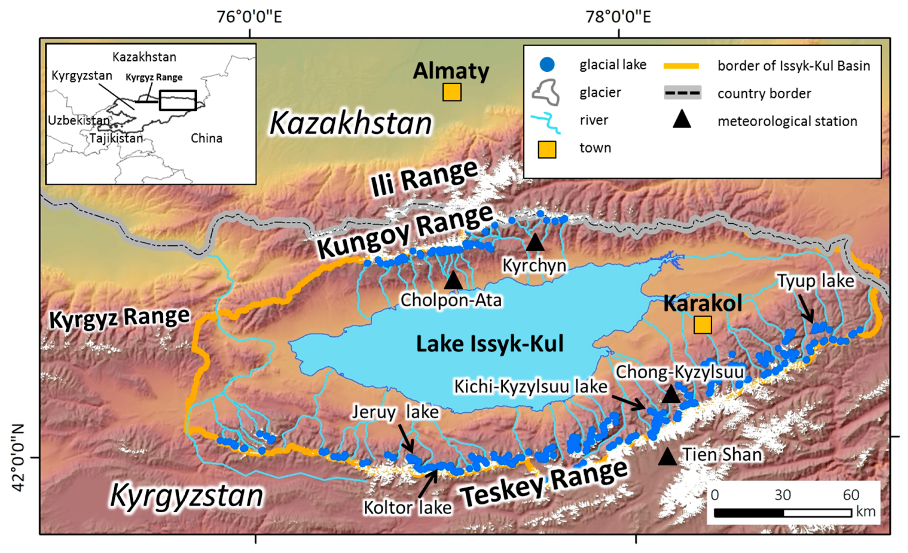
2. Study Area
3. Methods
3.1. Recent Variations of Glacial Lakes Using Satellite Data
3.2. Geomorphological Conditions of Glacial Lakes
3.3. Radar Interferometry of Debris Landforms
4. Results
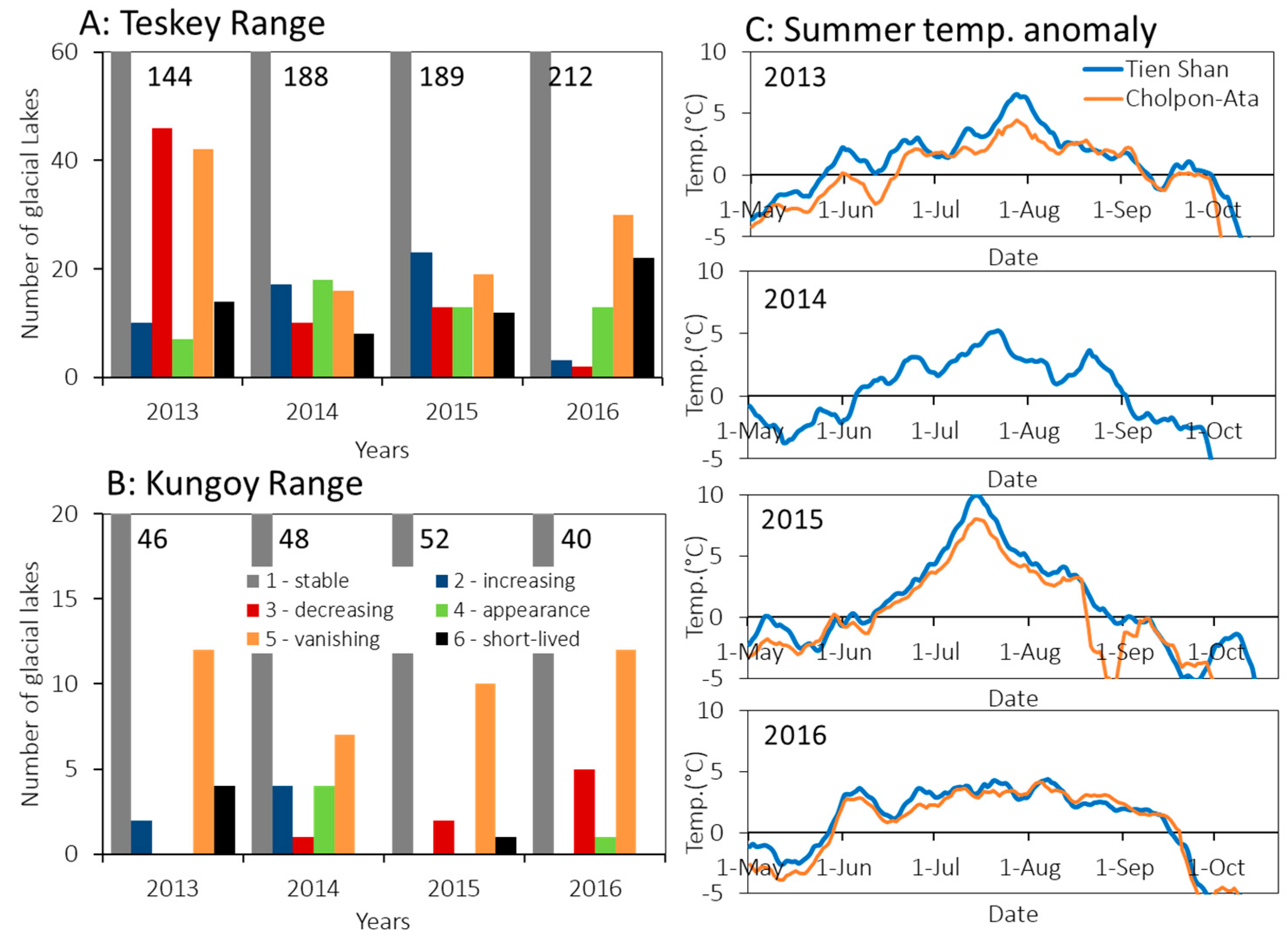
4.1. Recent Changes of Glacial Lakes in the Issyk-Kul Basin
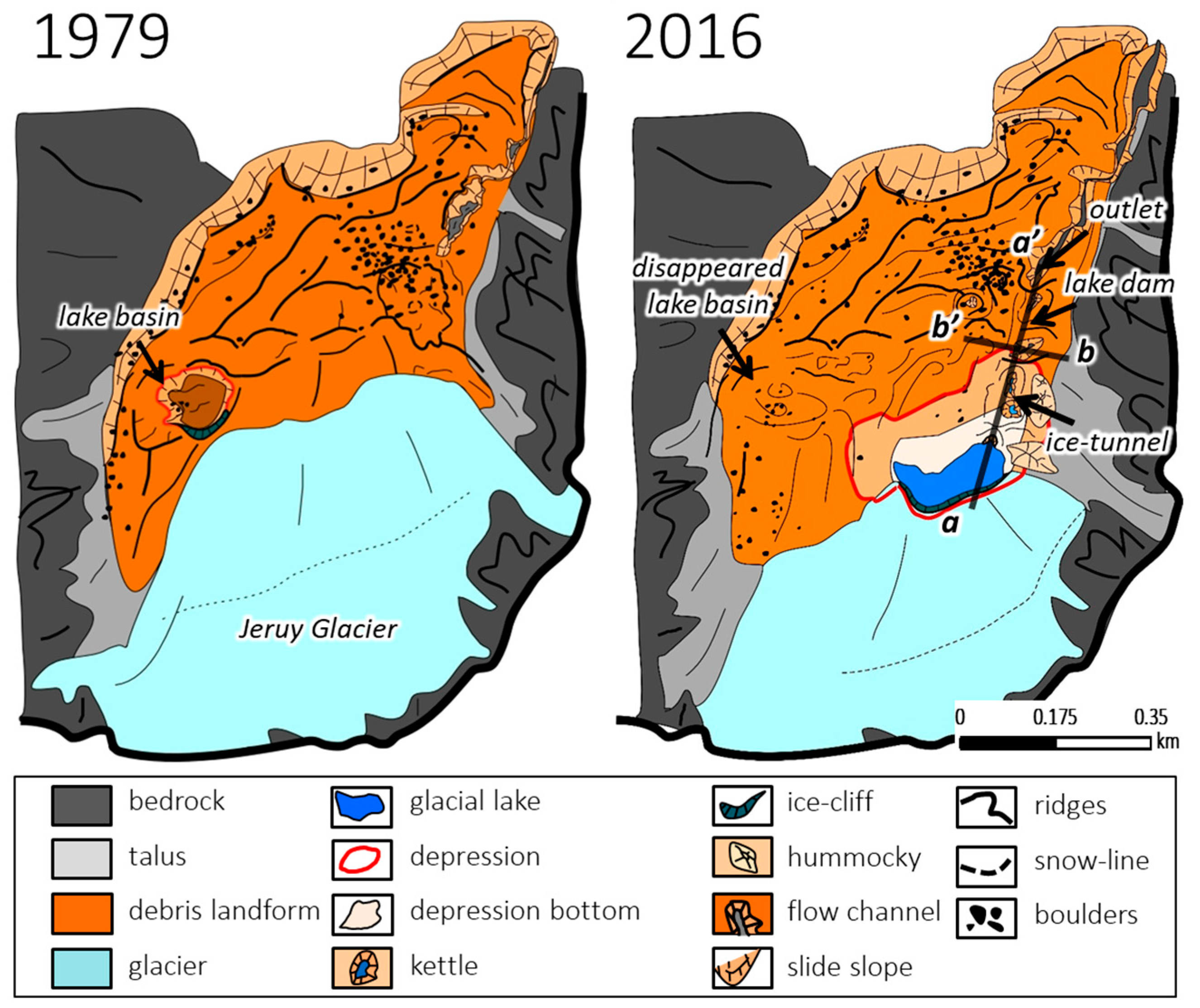
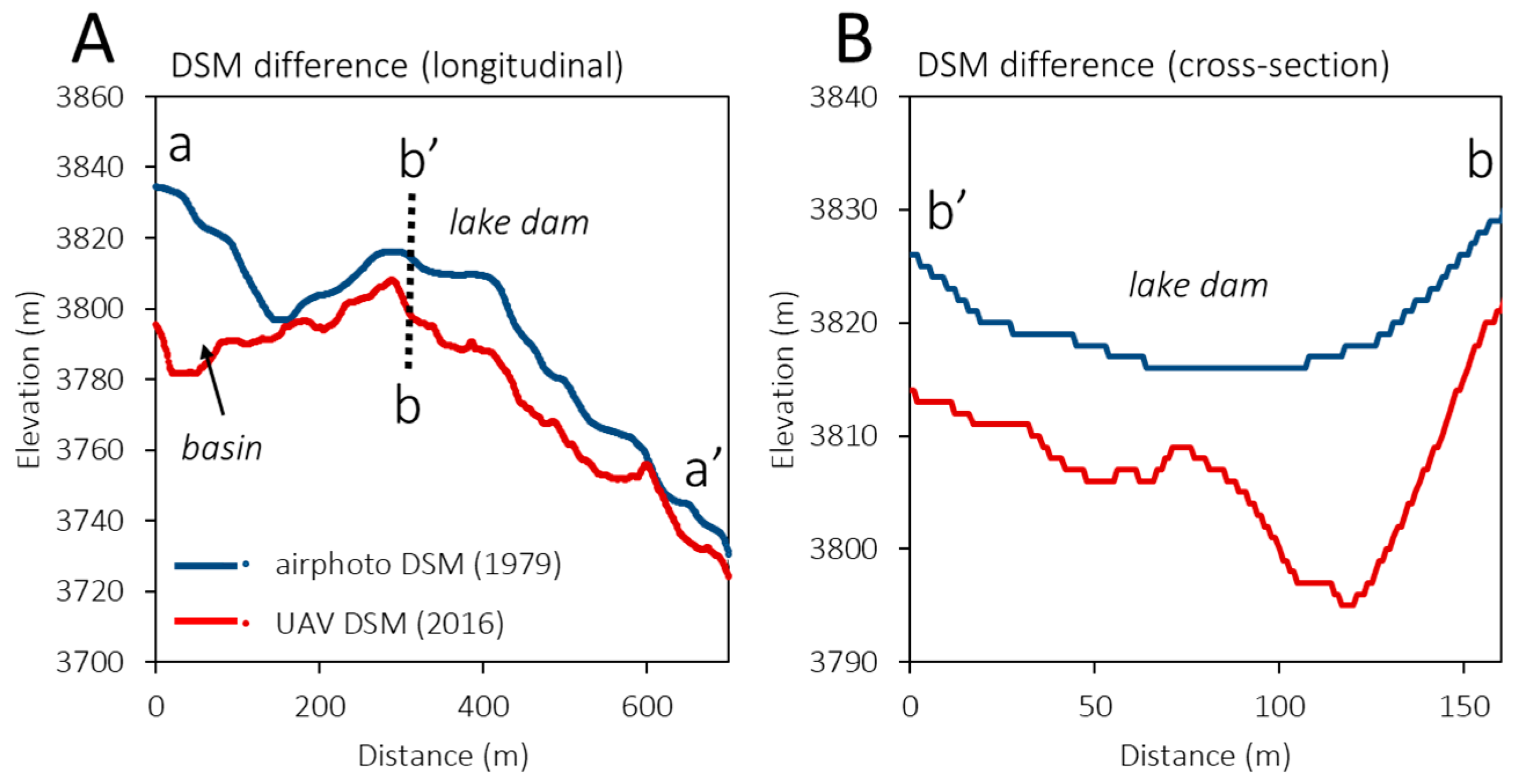
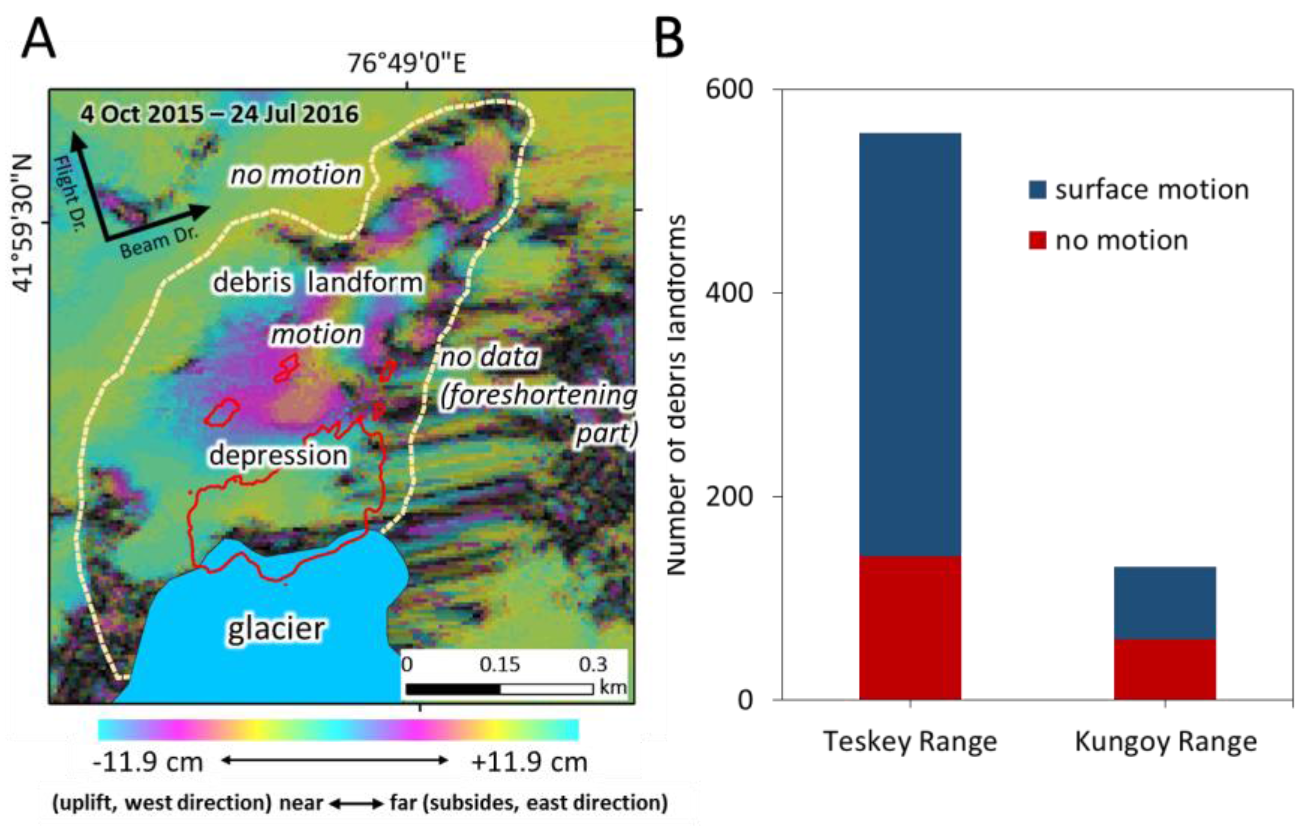
4.2. Recent Surface Changes of Debris Landform at Jeruy Glacier Front
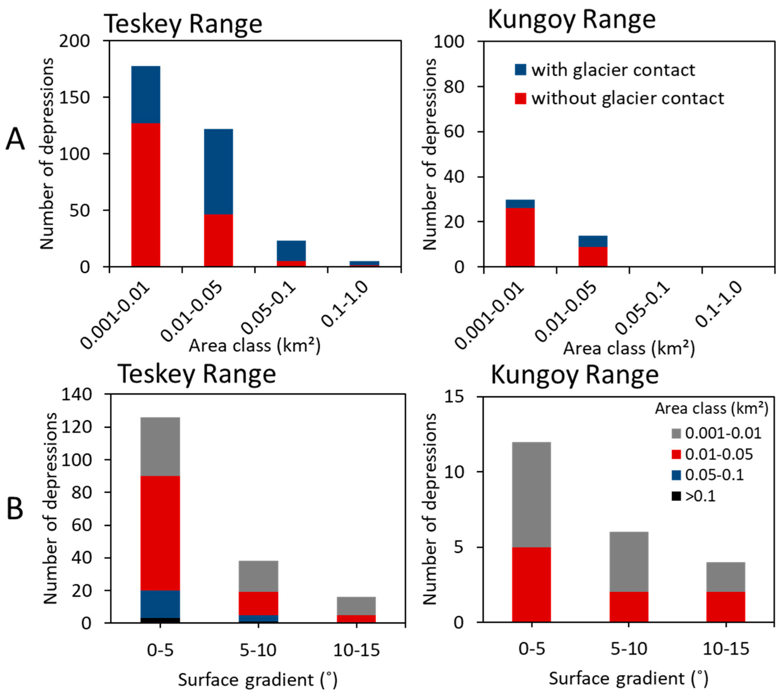
4.3. Analysis of Depressions on Debris Landforms
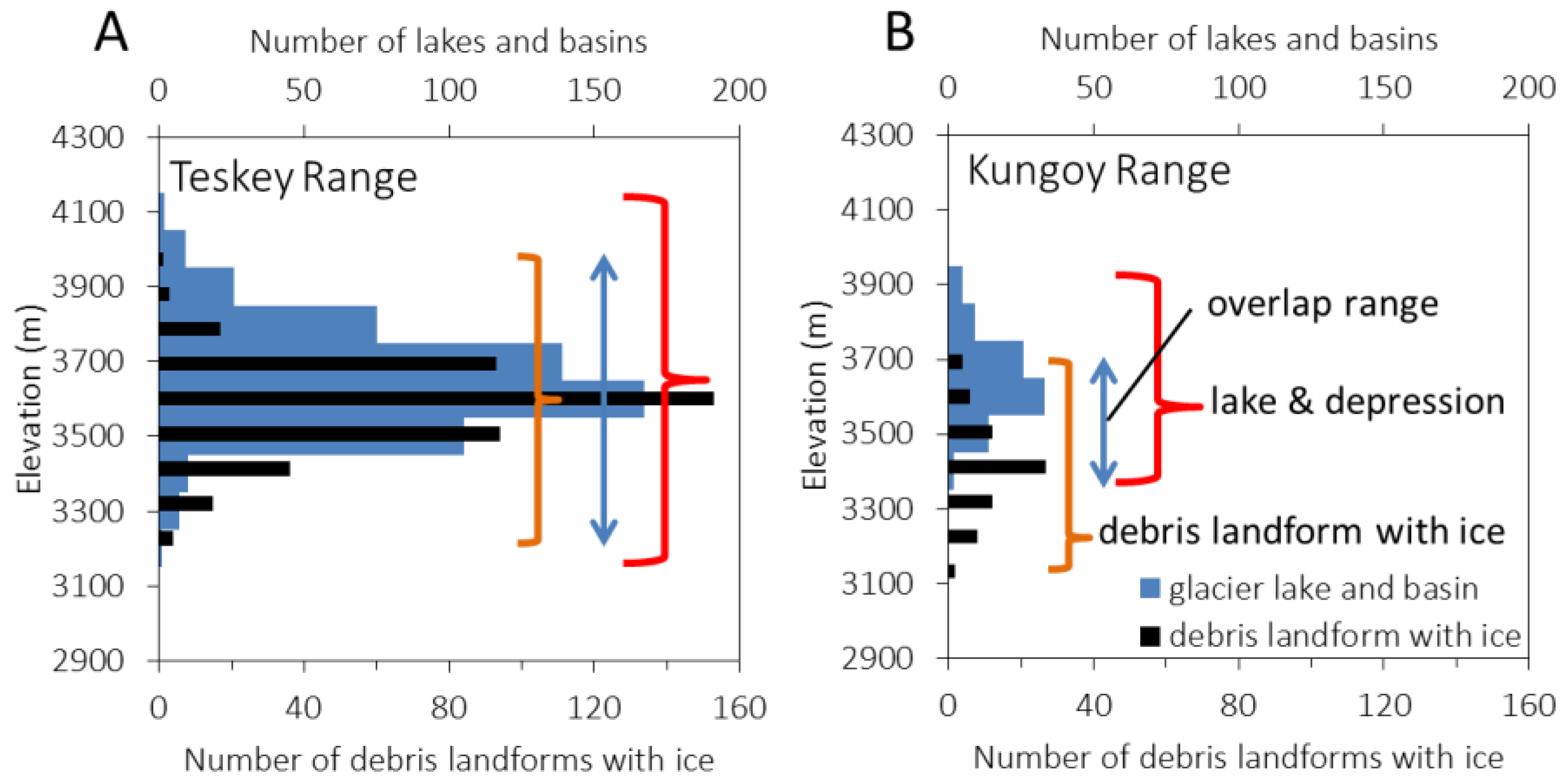
4.4. Distribution of Debris Landforms with Ground Ice
5. Discussion
5.1. Regional Geomorphological Conditions of the Glacial Lakes in the Issyk-Kul Basin
5.2. Differences of Regional Geomorphological Conditions between the Teskey and Kungoy Ranges
6. Conclusions
Supplementary Materials
Acknowledgments
Author Contributions
Conflicts of Interest
References
- Ageta, Y.; Iwata, S.; Yabuki, H.; Naito, N.; Sakai, A.; Narama, C.; Karma. Expansion of Glacier Lakes in Recent Decades in the Bhutan Himalayas; IAHS Publication: Wallingford, UK, 2000; pp. 165–175. [Google Scholar]
- Komori, J.; Gurung, D.R.; Iwata, S.; Yabuki, H. Variation and lake expansion of Chubda Glacier, Bhutan Himalayas, during the last 35 years. Bull. Glaciol. Res. 2004, 21, 49–55. [Google Scholar]
- Bajracharya, S.R.; Mool, P.K.; Shrestha, B.R. Impact of Climate Change on Himalayan Glaciers and Glacial Lakes: Case Studies on GLOF and Associated Hazards in Nepal and Bhutan; ICIMOD: Kathmandu, Nepal, 2007. [Google Scholar]
- Narama, C.; Duishonakunov, M.; Kääb, A.; Daiyrov, M.; Abdrakhmatov, K. The 24 July 2008 outburst flood at the western Zyndan glacier lake and recent regional changes in glacier lakes of the Teskey Ala-Too range, Tien Shan, Kyrgyzstan. Nat. Hazards Earth Syst. Sci. 2010a, 10, 647–659. [Google Scholar] [CrossRef]
- Baimoldaev, T.; Vinohodov, B. Kazselezaschita—Safety Measures before and after the Disasters; National Academy of Sciences of the Republic of Kazakhstan: Almaty, Kazakhstan, 2007. (In Russian) [Google Scholar]
- Kubrushko, S.S.; Shatravin, V.I. Long-term prediction of glacial mudflows in Tien Shan. Data Glaciol. Stud. 1982, 43, 60–62. (In Russian) [Google Scholar]
- Kubrushko, S.S.; Staviskiy, Y.S. Glacier lakes of Kyrgyzstan and their role in mudflow formation. Data Glaciol. Stud. 1978, 32, 59–62. (In Russian) [Google Scholar]
- Janský, B.; Šobr, M.; Engel, Z. Outburst flood hazard: Case studies from the Tien-Shan Mountains, Kyrgyzstan. Limnol.-Ecol. Manag. Inland Waters 2010, 40, 358–364. [Google Scholar] [CrossRef]
- Narama, C.; Severskiy, I.; Yegorov, A. Current state of glacier changes, glacial lakes, and outburst floods in the Ile Ala-Tau and Kungöy Ala-Too ranges, northern Tien Shan Mountains. Geogr. Stud. 2009, 84, 22–32. [Google Scholar] [CrossRef]
- Narama, C.; Daiyrov, M.; Duishonakunov, M.; Tadono, T.; Hayato, S.; Kääb, A.; Ukita, J.; Abdrakhmatov, K. Large drainage from short-lived glacial lakes in the Teskey Range, Tien Shan Mountains, Central Asia. Nat. Hazards Earth Syst. Sci. 2018, 18. [Google Scholar] [CrossRef]
- Nikitin, A.M.; Shchetinnikov, A.C. Mudflows in the Isfairamsai River-Basin in 1977. Data Glaciol. Stud. 1980, 39, 107–110. (In Russian) [Google Scholar]
- UNEP. Global Outlook for Ice and Snow; UNEP: Nairobi, Kenya, 2007. [Google Scholar]
- Mergili, M.; Kopf, C.; Müllebner, B.; Schneider, J.F. Changes of the cryosphere and related geohazards in the high-mountain areas of Tajikistan and Austria: A comparison. Geogr. Ann. Ser. A Phys. Geogr. 2012, 93, 79–96. [Google Scholar] [CrossRef]
- Mergili, M.; Schneider, J.F. Regional-scale analysis of lake outburst hazard in the southwestern Pamir, Tajikistan, based on remote sensing and GIS. Nat. Hazards Earth Syst. Sci. 2011, 11, 1447–1462. [Google Scholar] [CrossRef]
- Mergili, M.; Schneider, J.F.; Worni, R.; Schneider, J.F. Glacial lake outburst floods in the Pamir of Tajikistan: Challenges in prediction and modelling. In Proceedings of the 5th International Conference on Debris-Flow Hazards: Mitigation, Mechanics, Prediction and Assessment, Padua, Italy, 14–17 June 2011. [Google Scholar]
- Popov, N.V. Outburst glacial mudflows and their prevention in the mountains of Northern Tien Shan. Data Glaciol. Stud. 1987, 59, 188–193. (In Russian) [Google Scholar]
- Tokmagambetov, G.A.; Sudakov, P.A.; Plekhanov, P.A. Periglacial lakes in Zailiysky Alatau (Ile Range), Northern Tien Shan Mountains. Data Glaciol. Stud. 1980, 39, 97–101. (In Russian) [Google Scholar]
- Shatravin, V.I. Origin and structure of glacial lakes in Kyrgyzstan and mechanism of their outbursts. Trudy Kazn. Debris-Flows 1984, 8, 77–83. (In Russian) [Google Scholar]
- Erokhin, S. Data report of glacial lakes in 2000–2008. In Inventory of Glacial Lakes; Ministry of Emergency Situations of the Kyrgyz Republic: Bishkek, Kyrgyzstan, 2008. (In Russian) [Google Scholar]
- Janský, B.; Cerný, M.; Yerokhin, S. Mountain lakes of Kyrgyzstan with regard to the risk of their rupture. In EGU General Assembly Conference Abstracts, Proceeding of the EGU General Assembly 2009, Vienna, Austria, 19–24 April 2009; European Geosciences Union: Munich, Germany, 2009; EGU2009-14084-1. [Google Scholar]
- Keremkulov, V.A.; Tsukerman, I.G. Computations of the outburst flood generated by the emptying of morainic lake through englacial drainage system. Data Glaciol. Stud. 1986, 58, 110–111. (In Russian) [Google Scholar]
- Kapitsa, V.; Shahgedanova, M.; Machguth, H.; Severskiy, I.; Medeu, A. Assessment of evolution and risks of glacier lake outbursts in the Djungarskiy Alatau, Central Asia, using Landsat imagery and glacier bed topography modelling. Nat. Hazards Earth Syst. Sci. 2017, 17, 1837–1856. [Google Scholar] [CrossRef]
- Wang, X.; Ding, Y.; Liu, S.; Jiang, L.; Wu, K.; Jiang, Z.; Guo, W. Changes of glacial lakes and implications in Tian Shan, Central Asia, based on remote sensing data from 1990 to 2010. Environ. Res. Lett. 2013, 8, 1–11. [Google Scholar] [CrossRef]
- Bolch, T.; Peters, J.; Yegorov, A.; Pradhan, B.; Buchroithner, M.; Blagoveshchensky, V. Identification of otentially dangerous glacial lakes in the northern Tien Shan. Nat. Hazards 2011, 59, 1691–1714. [Google Scholar] [CrossRef] [Green Version]
- Tokmagambetov, G.A.; Sudakov, P.A.; Plekhanov, P.A. Glacial mudflows in Zailiysky Alatau (Ile Range) and ways of their prediction. Data Glaciol. Stud. 1982, 43, 63–68. (In Russian) [Google Scholar]
- De Batist, M.; Imbo, Y.; Vermeesch, P.M.; Klerkx, J.; Giralt, S.; Delvaux, D.; Lignier, V.; Beck, C.; Kalugin, I.; Abdrakhmatov, K.Y. Bathymetry and sedimentary environments of Lake Issyk-Kul, Kyrgyz Republic (Central Asia): A large, high altitude, tectonic lake. In Lake Issyk-Kul: Its Natural Environment; Klerkx, J., Imanackunov, B., Eds.; Kluwer Academic Publishers: Dordrecht, The Netherlands, 2002; pp. 101–123. [Google Scholar]
- Geological Map of the Kyrgyz SSR of 1:500,000 Scale; Academy of Sciences of the Kyrgyz SSR: Bishkek, Kyrgyzstan, 1987; pp. 38–39.
- Narama, C.; Kääb, A.; Duishonakunov, M.; Abdrakhmatov, K. Spatial variability of recent glacier area changes in the Tien Shan Mountains, Central Asia, using Corona (~1970), Landsat (~2000), and ALOS (~2007) satellite data. Glob. Planet. Chang. 2010, 71, 42–54. [Google Scholar] [CrossRef]
- Narama, C.; Shimamura, Y.; Nakayama, D.; Abdrakhmatov, K. Recent changes of glacier coverage in the western Terskey-Alatoo Range, Kyrgyz Republic, using Corona and Landsat. Ann. Glaciol. 2006, 43, 223–229. [Google Scholar] [CrossRef]
- Bolch, T. Climate change and glacier retreat in northern Tien Shan (Kazakhstan/Kyrgyzstan) using remote sensing data. Glob. Planet. Chang. 2007, 56, 1–12. [Google Scholar] [CrossRef]
- Kutuzov, S.; Shahgedanova, M. Glacier retreat and climatic variability in the eastern Terskey-Alatoo, inner Tien Shan between the middle of the 19th century and beginning of the 21st century. Glob. Planet. Chang. 2009, 69, 59–70. [Google Scholar] [CrossRef]
- Takaku, J.; Tadono, T. PRISM on-orbit geometric calibration and DEM performance. IEEE Trans. Geosci. Remote Sens. 2009, 47, 4060–4073. [Google Scholar] [CrossRef]
- Tadono, T.; Kawamoto, S.; Narama, C.; Yamanokuchi, T.; Ukita, J.; Tomiyama, N.; Yabuki, H. Development and validation of new glacial lake inventory in the Bhutan Himalayas using ALOS ‘DAICHI’. Glob. Environ. Res. 2012, 16, 31–40. [Google Scholar]
- Narama, C.; Daiyrov, M.; Tadono, T.; Yamamoto, M.; Kääb, A.; Morita, R.; Ukita, J. Seasonal drainage of supraglacial lakes on debris-covered glaciers in the Tien Shan Mountains, Central Asia. Geomorphology 2017, 286, 133–142. [Google Scholar] [CrossRef]
- Mergili, M.; Müller, J.; Schneider, J.F. Spatio-temporal development of high-mountain lakes in the headwaters of the Amu Darya River (Central Asia). Glob. Planet. Chang. 2013, 107, 13–24. [Google Scholar] [CrossRef]
- Sandwell, D.T.; Myer, D.; Mellors, R.; Shimada, M.; Brooks, B.; Foster, J. Accuracy and Resolution of ALOS Interferometry: Vector Deformation Maps of the Father’s Day Intrusion at Kilauea. IEEE Trans. Geosci. Remote Sens. 2008, 11, 3524–3534. [Google Scholar] [CrossRef]
- Natsuaki, R.; Nagai, H.; Motohka, T.; Ohki, M.; Watanabe, M.; Thapa, R.B.; Tadono, T.; Shimada, M.; Suzuki, S. SAR interferometry using ALOS-2 PALSAR-2 data for the Mw 7.8 Gorkha, Nepal earthquake. Earth Planets Space 2016. [Google Scholar] [CrossRef]
- Yamamura, A.; Narama, C.; Tomiyama, N.; Tadono, T.; Yamanokuchi, T.; Daiyrov, M.; Kääb, A.; Ukita, J. Spatial distribution of permafrost in the Kyrgzy Range, Northern Tien Shan using DInSAR analysis for rock glaciers. Permafr. Periglac. Process. submitted.
- Strozzi, T.; Kääb, A.; Frauenfelder, R. Detecting and quantifying mountain permafrost creep from in situ inventory, space-borne radar interferometry and airborne digital photogrammetry. Int. J. Remote Sens. 2004, 25, 2919–2931. [Google Scholar] [CrossRef]
- Lilleøren, K.; Etzelmüller, B.; Gärtner-Roer, I.; Kääb, A.; Westermann, S.; Gudmundsson, A. The Distribution, Thermal Characteristics and Dynamics of Permafrost in Trollaskagi, Northern Iceland, as Inferred from the Distribution of Rock Glaciers and Ice-Cored Moraines. Permafr. Periglac. Process. 2013, 24, 322–335. [Google Scholar] [CrossRef]
- Liu, L.; Millar, C.I.; Westfall, R.D.; Zebker, H.A. Surface motion of active rock glaciers in the Sierra Nevada, California, USA: Inventory and a case study using InSAR. Cryosphere 2013, 7, 1109–1119. [Google Scholar] [CrossRef]
- Werner, C.; Wegmüller, U.; Strozzi, T.; Wiesmann, A. Gamma SAR and Interferometric Processing Software. In Proceedings of the ERS-ENVISAT Symposium, Gothenburg, Sweden, 16–20 October 2000. [Google Scholar]
- Quincey, D.J.; Richardson, S.D.; Luckman, A.; Lucas, R.M.; Reynolds, J.M.; Hambrey, M.J.; Glasser, N.F. Early recognition of glacial lake hazards in the Himalaya using remote sensing datasets. Glob. Planet. Chang. 2007, 56, 137–152. [Google Scholar] [CrossRef]
- Goldstein, R.M.; Werner, C.L. Radar Ice Motion Interferometry. In Proceedings of the 3rd ERS ESA Symposium, ESA SP, Florence, Italy, 14–21 March 1997; pp. 969–972. [Google Scholar]
- Kääb, A.; Haeberli, W. Evolution of a High-Mountain Thermokarst Lake in the Swiss Alps. Arct. Antarct. Alp. Res. 2001, 33, 385–390. [Google Scholar] [CrossRef]
- Kropáček, J.; Neckel, N.; Tyrna, B.; Holzer, N.; Hovden, A.; Gourmelen, N.; Schneider, C.; Buchroithner, M.; Hochschild, V. Repeated glacial lake outburst flood threatening the oldest Buddhist monastery in north-western Nepal. Nat. Hazards Earth Syst. Sci. 2015, 15, 2425–2437. [Google Scholar] [CrossRef]
- Emmer, A.; Vilímek, V.; Zapata, M.L. Hazard mitigation of glacial lake outburst floods in the Cordillera Blanca (Peru): The effectiveness of remedial works. J. Flood Risk Manag. 2016. [Google Scholar] [CrossRef]


© 2018 by the authors. Licensee MDPI, Basel, Switzerland. This article is an open access article distributed under the terms and conditions of the Creative Commons Attribution (CC BY) license (http://creativecommons.org/licenses/by/4.0/).
Share and Cite
Daiyrov, M.; Narama, C.; Yamanokuchi, T.; Tadono, T.; Kääb, A.; Ukita, J. Regional Geomorphological Conditions Related to Recent Changes of Glacial Lakes in the Issyk-Kul Basin, Northern Tien Shan. Geosciences 2018, 8, 99. https://doi.org/10.3390/geosciences8030099
Daiyrov M, Narama C, Yamanokuchi T, Tadono T, Kääb A, Ukita J. Regional Geomorphological Conditions Related to Recent Changes of Glacial Lakes in the Issyk-Kul Basin, Northern Tien Shan. Geosciences. 2018; 8(3):99. https://doi.org/10.3390/geosciences8030099
Chicago/Turabian StyleDaiyrov, Mirlan, Chiyuki Narama, Tsutomu Yamanokuchi, Takeo Tadono, Andreas Kääb, and Jinro Ukita. 2018. "Regional Geomorphological Conditions Related to Recent Changes of Glacial Lakes in the Issyk-Kul Basin, Northern Tien Shan" Geosciences 8, no. 3: 99. https://doi.org/10.3390/geosciences8030099
APA StyleDaiyrov, M., Narama, C., Yamanokuchi, T., Tadono, T., Kääb, A., & Ukita, J. (2018). Regional Geomorphological Conditions Related to Recent Changes of Glacial Lakes in the Issyk-Kul Basin, Northern Tien Shan. Geosciences, 8(3), 99. https://doi.org/10.3390/geosciences8030099