Landscape Dynamics in the Caspian Lowlands Since the Last Deglaciation Reconstructed From the Pedosedimentary Sequence of Srednaya Akhtuba, Southern Russia

 , , , , and
Abstract
:1. Introduction
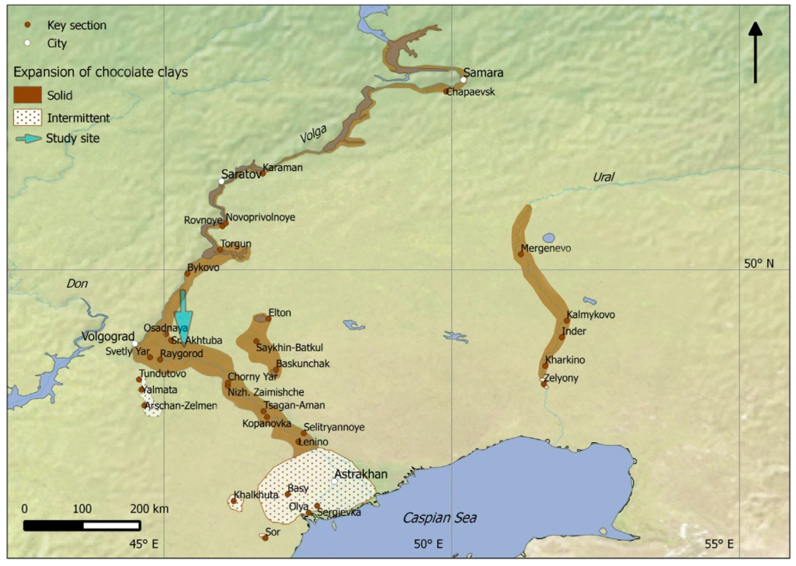
2. Study Area
3. Materials and Methods
4. Results
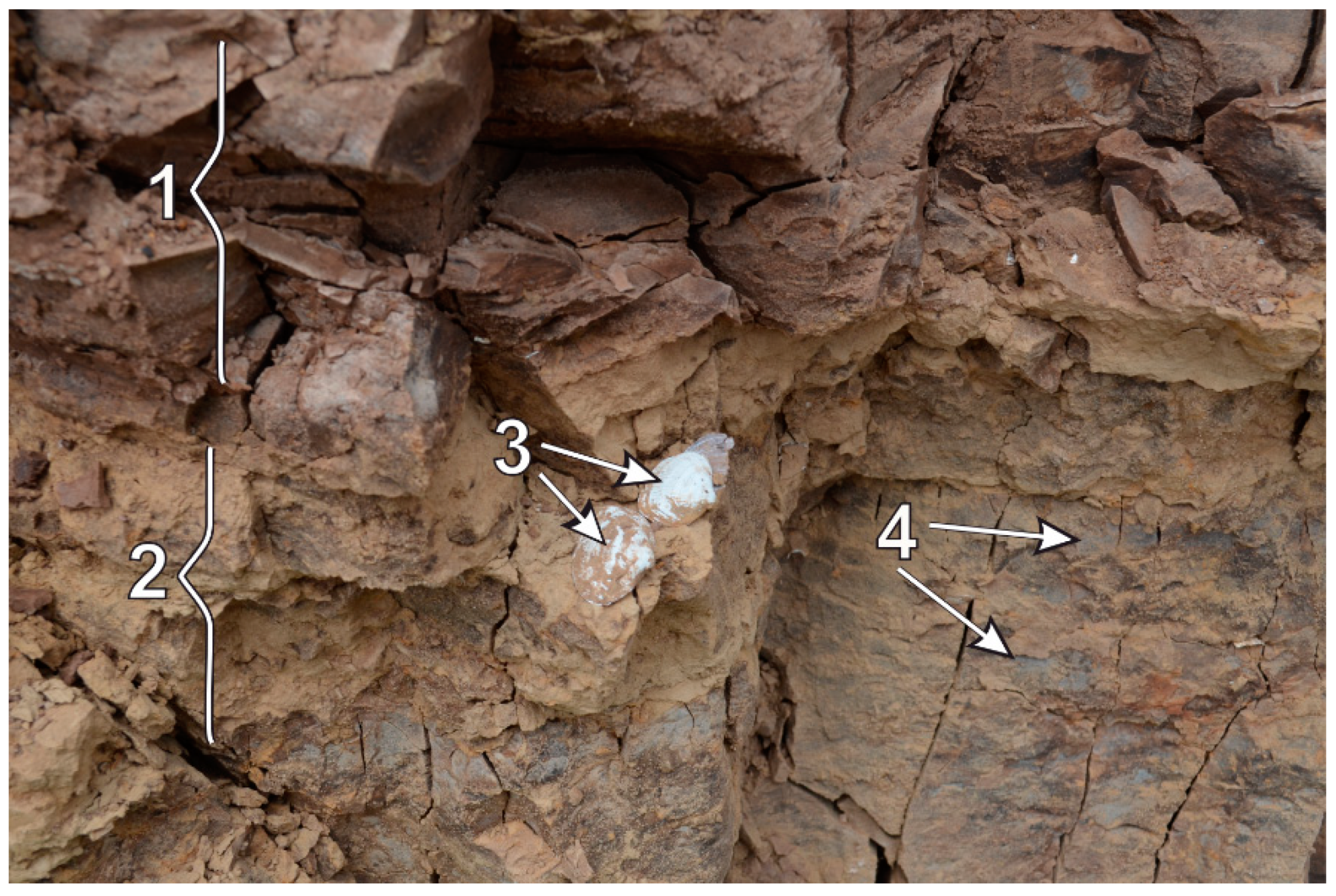
4.1. Field Morphology
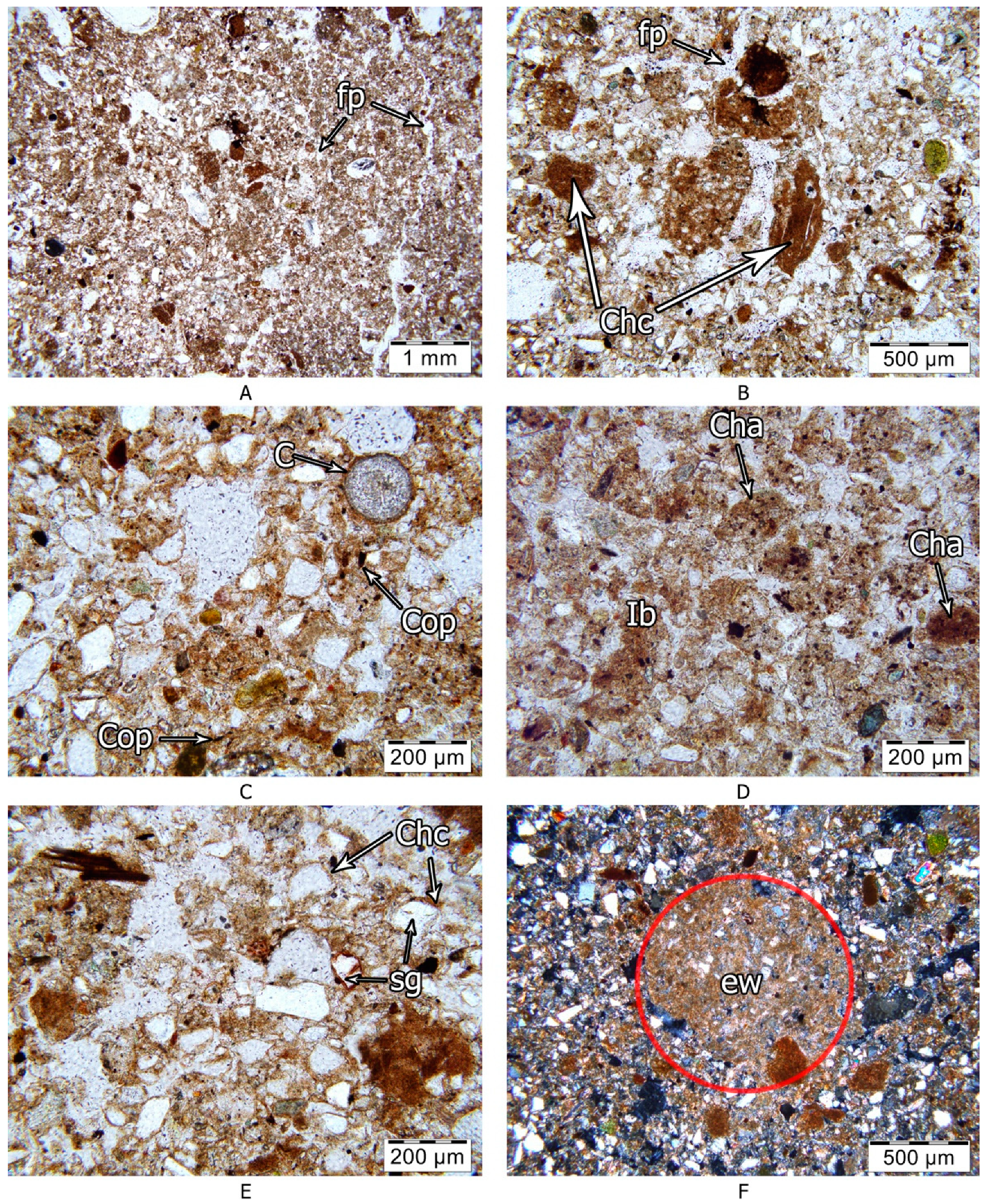
4.2. Soil Micromorphology
4.3. Analytical Features
5. Discussion
6. Conclusions
- The complex study of surface Calcic Kastanozem in the exposure of Srednaya Akhtuba shows that it developed in a pedocomplex that formed between the time of the last deglaciation and Boreal time. The pedocomplex includes a layer of loess underlain by Chocolate clay. The loess exhibits properties typical for aeolian sediments and indicates the local source for aeolian transport (enrichments in fragments of Chocolate clays and glauconitic grains, the similarity in clay mineralogy and the type of salinity). Chocolate clays influence the composition of the upper loess layer, e.g., clay fragments are responsible for its heavy texture and high gypsum content.
- The shift from marine to subareal sedimentation was a complex process accompanied by breaks that made the development of buried horizons of synlithogenic soils possible.
- The features of shallow buried soil horizons confirm increasing aridity during the Late Khvalynian, and after the Khvalynian time up to the Boreal period. The lower part of surface Calcic Kastanozem (below 100 cm) is superimposed on shallow buried soil horizons of cryoarid soil.
- Surface Calcic Kastanozem fully reflects modern climatic conditions of the dry steppe. However, it is deeply influenced by shallow buried soils and Chocolate clays.
- Srednaya Akhtuba is a unique exposure, with both marine and continental sediments of the time of the last deglaciation. The results of this study could be further used for broader paleoclimatic reconstructions for the whole Ponto-Caspian area.
Author Contributions
Funding
Conflicts of Interest
References
- Yanina, T.A. The Ponto-Caspian region: Environmental consequences of climate change during the Late Pleistocene. Quat. Int. 2014, 345, 88–99. [Google Scholar] [CrossRef]
- Svitoch, A.A. Khvalynian transgression of the Caspian Sea was not a result of water overflow from the Siberian Proglacial lakes, nor a prototype of the Noachian flood. Quat. Int. 2009, 197, 115–125. [Google Scholar] [CrossRef]
- Svitoch, A.A. The Neoeuxinian basin of the Black Sea and the Khvalinian transgression of the Caspian Sea. Quat. Int. 2010, 225, 230–234. [Google Scholar] [CrossRef]
- Tudryn, A.; Leroy, S.A.; Toucanne, S.; Gibert-Brunet, E.; Tucholka, P.; Lavrushin, Y.A.; Dufaure, O.; Miska, S.; Bayon, G. The Ponto-Caspian basin as a final trap for southeastern Scandinavian Ice-Sheet meltwater. Quat. Sci. Rev. 2016, 148, 29–43. [Google Scholar] [CrossRef]
- Zhukov, M.M. The differential vertical movements of the shores of the Caspian sea in Quaternary time. Uch. Zap. Mosc. State Univ. Geogr. 1941, 48, 25–32. (In Russian) [Google Scholar]
- Britsyna, I.P. Distribution of the Khvalynian Chocolate Clays and Problems of the Paleogeography of the North Caspian Region; Institute of Geography, Academy of Sciences of the USSR: Moscow, Russia, 1954; Volume 62, pp. 5–27. (In Russian) [Google Scholar]
- Makshaev, R.R.; Svitoch, A.A. Chocolate clays of the Northern Caspian Sea Region: Distribution, structure, and origin. Quat. Int. 2016, 409, 44–49. [Google Scholar] [CrossRef]
- Bolshakov, A.F.; Borovsky, V.M. Soils and microrelief of the Caspian lowland (according to the materials of the Dzhanybek stationary of the Soil Institute of the Academy of Sciences of the USSR). In Materials of Surveys, Studies and Design of the Volga Irrigation: “Solontsy of the Volga Region”; Publishing House of the Academy of Agricultural Sciences: Moscow, Russia, 1937; Volume 7, pp. 134–169. (In Russian) [Google Scholar]
- Budina, L.P. Meadow brown semidesert soils. In Genesis and Classification of Semidesert Soils; Nauka (USSR): Moscow, Russia, 1966; pp. 59–72. (In Russian) [Google Scholar]
- Ivanova, E.N. (Ed.) Soils of the Complex Northern Caspian Plain and Their Characteristics for Reclamation Purposes; Nauka: Moscow, Russia, 1964. [Google Scholar]
- Kovda, V.A. Soils of the Caspian Lowland; Izd. Akad. Nauk SSSR: Moscow, Russia, 1950; p. 249. (In Russian) [Google Scholar]
- Rode, A.A.; Pol’skij, M.N. Soils of the semi-desert of the North-Western Caspian region and their reclamation. In Proceedings of V.V. Dokuchaev Soil Science Institute; USSR AS Publishing: Moscow, Russia, 1961; Volume 56, pp. 3–214. (In Russian) [Google Scholar]
- Sotneva, N.I. The dynamics of climatic conditions at the Dzhanybek Research Station in the northern CaspianLowland in the second half of the XXth century. In Izvestiya RAN; Geographical Series; Nauka: Moscow, Russia, 2004; Volume 5, pp. 74–83. (In Russian) [Google Scholar]
- Arslanov, K.A.; Druzhinina, O.A.; Kublitsky, Y.A.; Subetto, D.A.; Syrykh, L.S. New data on Palaeoenvironment of South-Eastern Baltic region: Results of researches of 2011–2013. In VIII All-Russian Conference on Quaternary Research: «Fundamental Problems of Quaternary,results and Main Trends of Future Studies»; SSC RAS Publishers: Rostov-on-Don, Russia, 2013; pp. 34–36. (In Russian) [Google Scholar]
- Thompson, W.; Kurbanov, R.; Murray, A.; Yanina, T.; Svistunov, M.; Yarovaya, S. First optically-stimulated luminescence ages of the early Khvalynian “Chocolate clays” of the lower Volga. In Proceedings of the International Conference Loessfest 2018 Diversity of Loess: Properties, Stratigraphy, Origin and Regional Features, Volgograd, Russia, 24–29 September 2018; pp. 122–123. [Google Scholar]
- Kurbanov, R.N.; Murray, A.S.; Yanina, T.A.; Svistunov, M.I.; Taratunina, N.A.; Thompson, W.K. First optically stimulated luminescence ages of the Early Khvalynian Caspian Sea transgression in the Lower Volga. Quaternary Geochronology 2019, 52. in press. [Google Scholar]
- Moskvitin, A.I. Pleistocene of the Lower Volga Region; Academy of Sciences of the USSR: Moscow, USSR, 1961; p. 264. (In Russian) [Google Scholar]
- Svitoch, A.A.; Yanina, T.A. Quaternary Sediments of the Coasts of the Caspian Sea; RASHN: Moscow, Russia, 1997; p. 267. [Google Scholar]
- Lavrushin, Y.A.; Spiridonov, E.A.; Tudrin, A.; Shali, F.; Antipov, M.P.; Kuralenko, N.P.; Kurina, E.E.; Tuholka, P. Caspian: Late Quarter hydrological events. Bull. Comm. Stud. Q. Period 2014, 3, 19–50. [Google Scholar]
- Tudryn, A.; Chalie, F.; Lavrushin, Y.A.; Antipov, M.P.; Spiridonova, E.A.; Lavrushin, V.; Tucholka, P.; Leroy, S.A.G. Late Quaternary Caspian Sea environment: Late Khazarian and Early Khvalynian transgressions from the lower reaches of the Volga River. Quat. Int. 2013, 292, 193–204. [Google Scholar] [CrossRef]
- Makeev, A.; Rusakov, A.; Bagrova, S.; Kurbanov, R.; Yanina, T. Pedogenetic response to climatic fluctuations within the last glacial-interglacial cycle in the lower Volga basin. In Proceedings of the IGCP 610 Fourth Plenary Conference and Field Trip from the Caspian to Mediterranean: Environmental Change and Human Response during the Quaternary, Tbilisi, Georgia, 2–9 October 2016; pp. 111–114. [Google Scholar]
- Yanina, T.A.; Svitoch, A.A.; Kurbanov, R.N.; Murray, A.S.; Tkach, N.T.; Sychev, N.Y. Paleogeographic analysis of the results of optically stimulated luminescence dating of pleistocene deposits of the Lower Volga area. Vestnik Mosk. Univ. Seriya Geogr. 2017, 2017, 20–28. (In Russian) [Google Scholar]
- Arslanov, K.A.; Yanina, T.A.; Chepalyga, A.L.; Svitoch, A.A.; Makshaev, R.R.; Maksimov, F.E.; Chernov, S.B.; Tertychniy, N.I.; Starikova, A.A. On the age of the Khvalynian deposits of the Caspian Sea coasts according to 14C and 230Th/234U methods. Quat. Int. 2016, 409, 81–87. [Google Scholar] [CrossRef]
- Guidelines for Soil Description, 4th ed.; Food and Agriculture Organization of the United Nations: Rome, Italy, 2006; p. 110.
- Munsell, A.H. Munsell Soil Color Charts: With Genuine Munsell* Color Chips; Munsell Color Company: Grand Rapids, MI, USA, 2013. [Google Scholar]
- IUSS Working Group WRB. World Reference Base for Soil Resources 2014, Update 2015 International Soil Classification System for Naming Soils and Creating Legends for Soil Maps; World Soil Resources Reports No. 106; FAO: Rome, Italy, 2015. [Google Scholar]
- Stoops, G. Guidelines for Analysis and Description of Soil and Regolith Thin Sections; Vepraskas, M.J., Ed.; Soil Science Society of America Inc.: Madison, WI, USA,.
- Kachinskiy, N.A. Soil Physics—Part 1; Higher Education Publishing House (USSR): Moscow, USSR, 1965; p. 321. (In Russian) [Google Scholar]
- Kozlovskiy, F.I. Methods of Salt Regime Assessment in Soils. In Methods of Stationary Studies of Soils; Science Publishing House (USSR): Moscow, USSR, 1977; pp. 88–166. (In Russian) [Google Scholar]
- Khitrov, N.B.; Ponizovskij, A.A. Guide to Laboratory Methods for Studying the Ion-Salt Composition of Neutral and Alkaline Mineral Soils; Vashnil, V.V., Ed.; Dokuchaev Soil Science Institute: Moscow, Russia, 1990; p. 235. (In Russian) [Google Scholar]
- Pankova, E.I.; Vorobyova, L.A.; Gadzhiyev, I.M.; Gorokhova, I.N.; Elizarova, T.N.; Korolyuk, T.V.; Lopatovskaya, O.G.; Novikova, A.F.; Reshetov, G.G.; Skripnikova, M.I.; et al. Salt-Affected Soils of Russia; Akademkniga: Moscow, Russia, 2006; p. 854. (In Russian) [Google Scholar]
- Gorbunov, N.I. Fine Minerals and Methods of Their Investigation; AS Publishing: Moscow, USSR, 1963; p. 302. (In Russian) [Google Scholar]
- Mehra, O.P.; Jackson, M.L. Iron oxide removal from soils and clays by a dithionite-citrate system buffered with sodium bicarbonate. In Clays and Clay Minerals; Ingerson, E., Ed.; Pergamon: Bergama, Turkey, 2013; pp. 317–327. [Google Scholar]
- Biscaye, P.E. Mineralogy and Sedimentation of the Deep-Sea Sediment Fine Fraction in the Atlantic Ocean and Adjacent Seas and Oceans; Department of Geology, Yale University: New Haven, CT, USA, 1964. [Google Scholar]
- Biscaye, R.E. Mineralogy and sedimentation of recent deep-sea clay in the Atlantic Ocean and adjacent Seas and Oceans. Bull. Geol. Soc. Am. 1965, 76, 803–832. [Google Scholar] [CrossRef]
- X-ray Methods of Studying and the Structure of Clay Minerals; Braun, G. (Ed.) Mir Publishing: Moscow, Russia, 1965; p. 599. (In Russian) [Google Scholar]
- Gradusov, B.P. X-ray diffractometry method in mineralogical studies of soils. Pochvovedenie 1967, 10, 127–137. (In Russian) [Google Scholar]
- Gradusov, B.P. Minerals with a Mixed Structure in Soils; USSR AS Publishing: Moscow, Russia, 1976. (In Russian) [Google Scholar]
- Sokolova, T.A.; Dronova, T.J.; Tolpeshta, I.I. Clay Minerals in Soils: Text Book; Akademkniga Pub: Moscow, Russia, 2005; p. 336. (In Russian) [Google Scholar]
- Svitoch, A.A.; Makshaev, R.R.; Rostovtseva, Y.V.; Klyuvitkina, T.S.; Berezner, O.S.; Tregub, T.F.; Khomchenko, D.S. Chocolate Clays of the Northern Caspian Sea Region; Faculty of Geography, Lomonosov Moscow State University: Moscow, Russia; OOO Krasnogorskaya Tipografiya: Moscow, Russia, 2017; p. 140. (In Russian) [Google Scholar]
- Priklonsky, V.; Gorkova, I.; Oknina, N. Engineeringgeological properties of Khvalynian clays in the context of environments of their deposition. In Trudy Laboratirii Gidrogeologicheskikh Problem; Laboratory for Hydrogeological Problems: Moscow, USSR, 1956; Volume 13, pp. 1–152. [Google Scholar]
- Kostov, I. Mineralogy; Mir: Moscow, USSR, 1971; Volume 40. (In Russian) [Google Scholar]
- Poch, R.M.; Artieda, O.; Lebedeva, M. Chapter 10—Gypsic Features. In Interpretation of Micromorphological Features of Soils and Regoliths, 2nd ed.; Stoops, G., Marcelino, V., Mees, F., Eds.; Elsevier: Amsterdam, The Netherlands, 2018; pp. 259–287. [Google Scholar]
- Abramova, T.A. Reconstruction of the Paleogeographical Environment of the Quaternary-Transgressions and Regressions of the Caspian Sea (on the Data of Paleobotany Investigations). Ph.D. Thesis, Moscow State University, Moscow, USSR, 1974. (In Russian). [Google Scholar]
- Rychagov, G.I. Pleistocene History of the Caspian Sea; Moscow State University Pub: Moscow, Russia, 1997; p. 267. (In Russian) [Google Scholar]
- Bolikhovskaya, N.S. Evolution of the Climate and Landscapes of the Lower Volga Region during Holocene. Vestnik Mosc. Univ. Geogr. 2011, 2, 13–27. (In Russian) [Google Scholar]
- Wintle, A.G. A review of current research on TL dating of loess. Quat. Sci. Rev. 1990, 9, 385–397. [Google Scholar] [CrossRef]
- Olley, J.; Caitcheon, G.; Murray, A. The distribution of apparent dose as determined by optically stimulated luminescence in small aliquots of fluvial quartz: Implications for dating young sediments. Quat. Sci. Rev. 1998, 17, 1033–1040. [Google Scholar] [CrossRef]
- Hilgers, A.; Murray, A.; Schlaak, N.; Radtke, U. Comparison of quartz OSL protocols using Lateglacial and Holocene dune sands from Brandenburg, Germany. Quat. Sci. Rev. 2001, 20, 731–736. [Google Scholar] [CrossRef]


| Horizon | Lower Boundary, cm | Colour of a General Matrix (moist) | Artifacts | Coatings | Salt Crystals | Structure | Carbonate Reaction | Forms of Secondary Carbonates | Forms of Secondary Gypsum | Type of Voids | Abundance of Roots | Horizon Boundary | Consistence | |
|---|---|---|---|---|---|---|---|---|---|---|---|---|---|---|
| Distinctness, cm | Topography | |||||||||||||
| Calcic Kastanozem | ||||||||||||||
| L | 0 | Steppe litter | A | S | ||||||||||
| Amo1 | 9 | 7.5 YR6/2 | N | – | – | GR(ME)WM + SB(ME)WM + PL(FI)WE | N | – | – | I-C-, C-V | Common | G | S | VFR to LO |
| Amo2 | 20 | 7.5 YR 4/4 | N | – | – | PL(ME)MS + SB(ME)WM | N | – | – | I-C, C-V | Many | C | W | VFR to FR |
| Bw | 40 | 7.5 YR 4/6 | ChC-F-V | CH, VT-F/THC | – | PS(FM)MO → AB(FI)WM | SL | – | – | I-C, C-V | Common | C | W | FI |
| Bcc1 | 65 | 7.5 YR 6/4 | ChC-F-F | CH, VT-V/TCH | – | AB(ME)WM | ST | D, SC | – | I-F, C-V | Very few | C | W | FR to VFR |
| Bcc2 | 80 | 7.5 YR 4/6 | ChC-C-F | CH, VT-V/TCH | Few | AB(ME)WM→ PL(VM)WE | ST | D, SC | – | I-F, C-V | Many | C | W | FR |
| Ahccb | 100 | 7.5 YR 5/4 | ChC-M-M | Few | CR(MC)WE → AS(VM)WE | MO | I-F, C-M | Few | G | S | FI to FR | |||
| 2Ahccb | 148 | 7.5 YR 4/3 | ChC-A-M | C, VT-V/P | Few | LU(MC)WE → AS(VM)WE | MO | – | D | I-F, C-V | Very few | A | S | FR |
| 3Ahccb | 160 | 7.5 YR 5/3 | Sh-M-C | CH, VT-V/PV ST,T-M/P | Few | AP(MC)ST | MO | D | P-M | – | – | – | VFI | |
| Horizon | Depth, cm | pHwater | CaCO3, % | TOC, g/100 g | Exchangeable Cations, % of CEC | Iron Fractions, % * | CaSO4x2H2O, % | ∑ of Soluble Salts, % | ||||||
|---|---|---|---|---|---|---|---|---|---|---|---|---|---|---|
| Ca2+ | Mg2+ | Na+ | K+ | Feo | Fed | Fec | FeO/Fed | |||||||
| Amo | 0–9 | 8.0 | 0.0 | 1.49 | 45.2 | 51.7 | 1.0 | 2.1 | 0.12 | 0.87 | 0.75 | 0.14 | n.d. | 0.24 |
| 9–20 | 8.2 | 0.0 | 1.20 | 45.6 | 52.1 | 0.8 | 1.5 | 0.09 | 0.98 | 0.89 | 0.09 | n.d. | 0.12 | |
| Bw | 20–40 | 8.3 | 1.30 | 0.89 | 60.8 | 37.4 | 0.7 | 1.1 | 0.10 | 1.12 | 1.02 | 0.09 | n.d. | 0.13 |
| Bcc1 | 40–65 | 8.7 | 16.6 | n.d. | 48.7 | 48.7 | 1.1 | 1.5 | 0.11 | 0.80 | 0.69 | 0.14 | n.d. | 0.30 |
| 8.7 | 17.8 | 0.52 | 36.6 | 61.0 | 1.5 | 1.0 | 0.10 | 0.85 | 0.75 | 0.12 | n.d. | 0.20 | ||
| Bcc2 | 65–80 | 8.4 | 11.0 | n.d. | 38.5 | 57.7 | 2.3 | 1.5 | 0.18 | 0.94 | 0.76 | 0.19 | n.d. | 0.19 |
| Ahccb | 80–100 | 8.2 | 6.6 | 0.35 | 32.0 | 64.0 | 2.7 | 1.4 | 0.10 | 0.94 | 0.84 | 0.11 | 0.00. | 0.31 |
| 2Ahccb | 100–148 | 8.0 | 7.8 | 0.28 | 49.1 | 43.6 | 6.0 | 1.3 | 0.23 | 1.20 | 0.97 | 0.19 | 3.72 | 1.79 |
| 8.1 | 8.0 | n.d. | 34.5 | 57.5 | 6.7 | 1.3 | 0.24 | 1.10 | 0.86 | 0.22 | 2.43 | 1.82 | ||
| 3Ahccb | 148–160 | 8.1 | 6.0 | 0.49 | 39.1 | 44.7 | 14.5 | 1.6 | 0.43 | 1.72 | 1.29 | 0.25 | 1.86 | 2.57 |
© 2018 by the authors. Licensee MDPI, Basel, Switzerland. This article is an open access article distributed under the terms and conditions of the Creative Commons Attribution (CC BY) license (http://creativecommons.org/licenses/by/4.0/).
Share and Cite
Lebedeva, M.; Makeev, A.; Rusakov, A.; Romanis, T.; Yanina, T.; Kurbanov, R.; Kust, P.; Varlamov, E. Landscape Dynamics in the Caspian Lowlands Since the Last Deglaciation Reconstructed From the Pedosedimentary Sequence of Srednaya Akhtuba, Southern Russia. Geosciences 2018, 8, 492. https://doi.org/10.3390/geosciences8120492
Lebedeva M, Makeev A, Rusakov A, Romanis T, Yanina T, Kurbanov R, Kust P, Varlamov E. Landscape Dynamics in the Caspian Lowlands Since the Last Deglaciation Reconstructed From the Pedosedimentary Sequence of Srednaya Akhtuba, Southern Russia. Geosciences. 2018; 8(12):492. https://doi.org/10.3390/geosciences8120492
Chicago/Turabian StyleLebedeva, Marina, Alexander Makeev, Alexey Rusakov, Tatiana Romanis, Tamara Yanina, Redzhep Kurbanov, Pavel Kust, and Evgeniy Varlamov. 2018. "Landscape Dynamics in the Caspian Lowlands Since the Last Deglaciation Reconstructed From the Pedosedimentary Sequence of Srednaya Akhtuba, Southern Russia" Geosciences 8, no. 12: 492. https://doi.org/10.3390/geosciences8120492