Detrital Zircon Fission-Track Thermochronology of the Present-Day Isère River Drainage System in the Western Alps: No Evidence for Increasing Erosion Rates at 5 Ma

Abstract
:1. Introduction
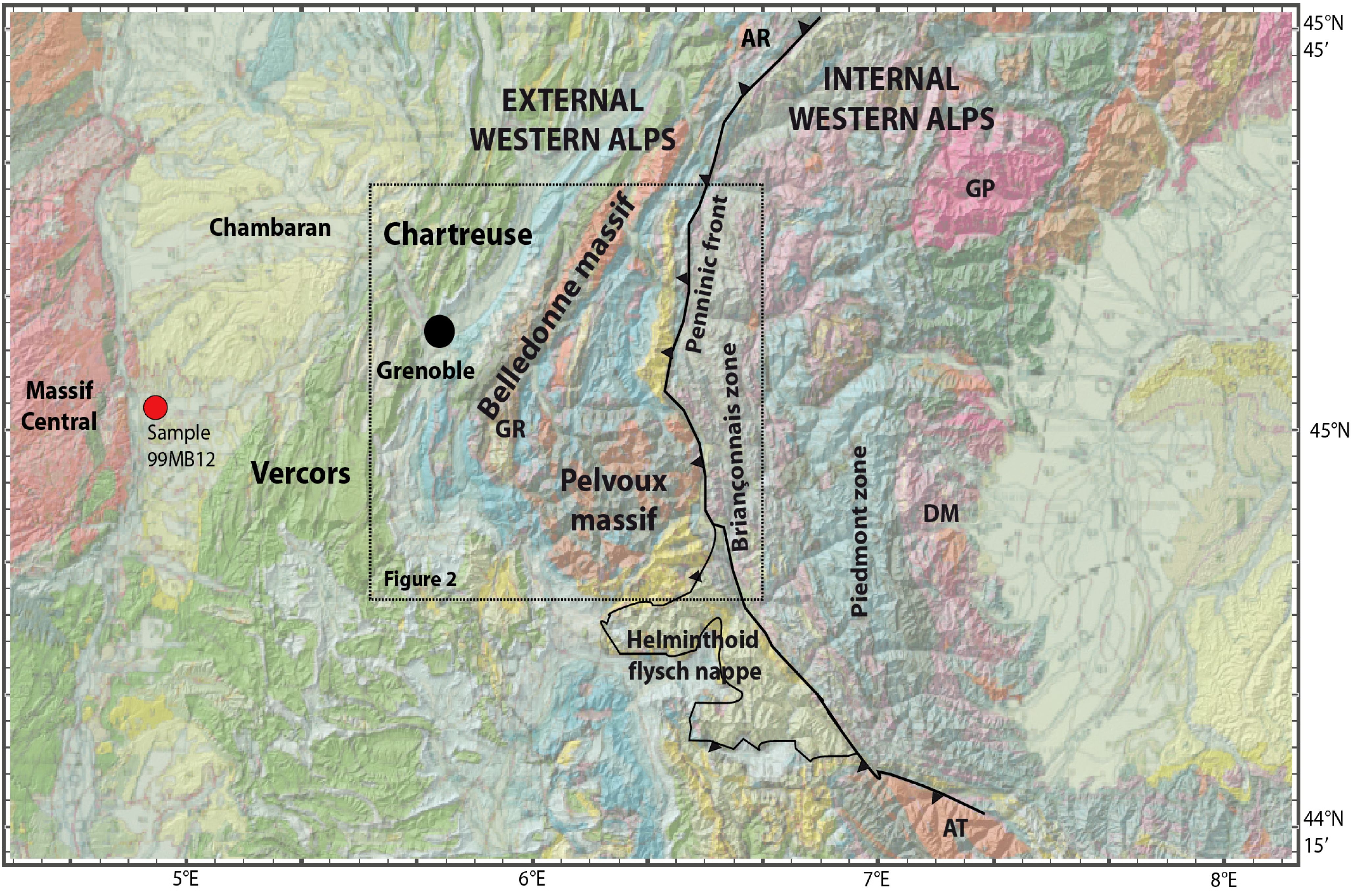
2. Geological Setting

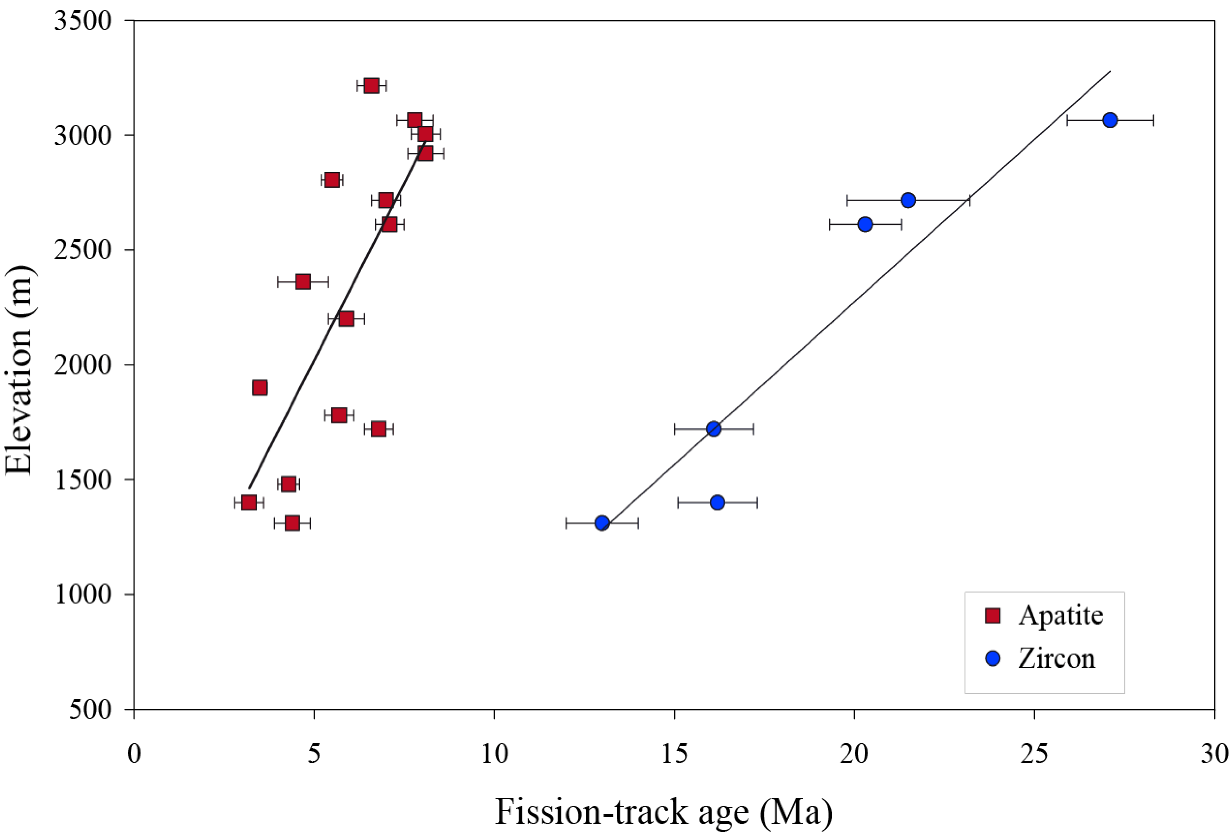
3. Previous Thermochronologic Work in the Isère River Drainage Area

4. Methods

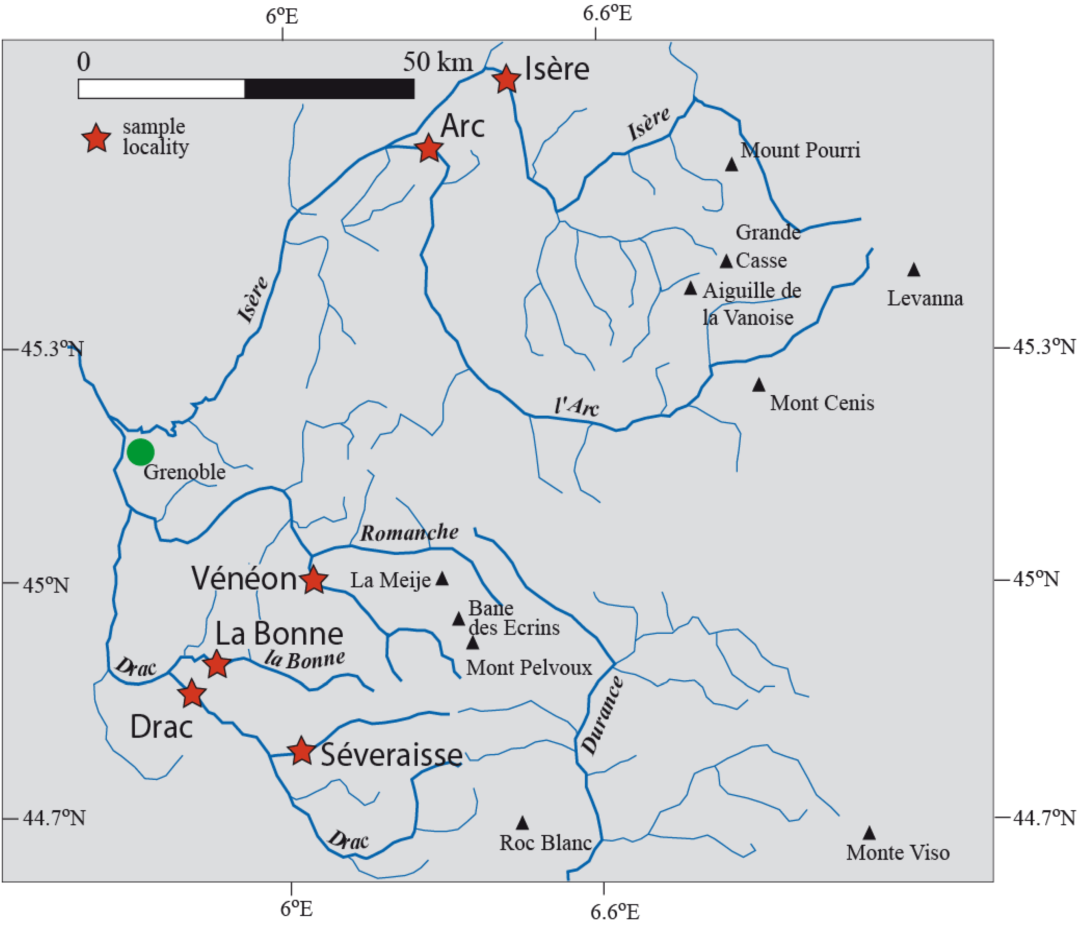
| Sample No. | River | Latitude | Longitude | Altitude | Locality |
|---|---|---|---|---|---|
| 04MB129 | La Bonne | N 44.89758° | E 5.92480° | 745 m | near Valbonne |
| 04MB130 | Drac | N 44.79351° | E 5.97391° | 764 m | near Ambel |
| 04MB131 | Arc | N 45.55579° | E 6.25442° | 303 m | near Aiton |
| 04MB132 | (upper) Isère | N 45.65057° | E 6.43442° | 363 m | near Tour en Savoie |
| 04MB145 | Vénéon | N 45.01297° | E 6.06382° | 750 m | near Venosc |
| 04MB146 | La Séveraisse | N 44.78396° | E 6.06249° | 888 m | near Le Séchier |

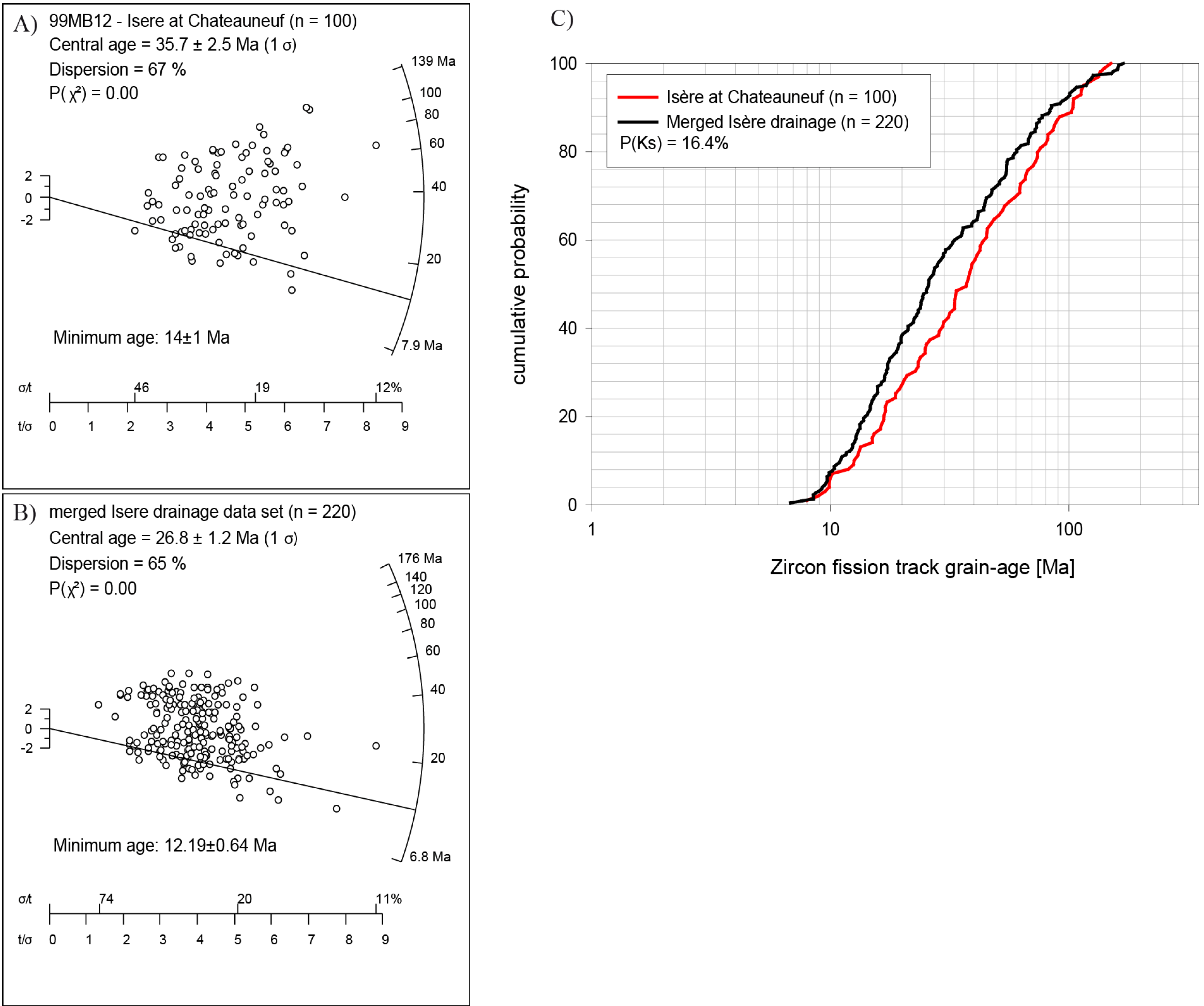
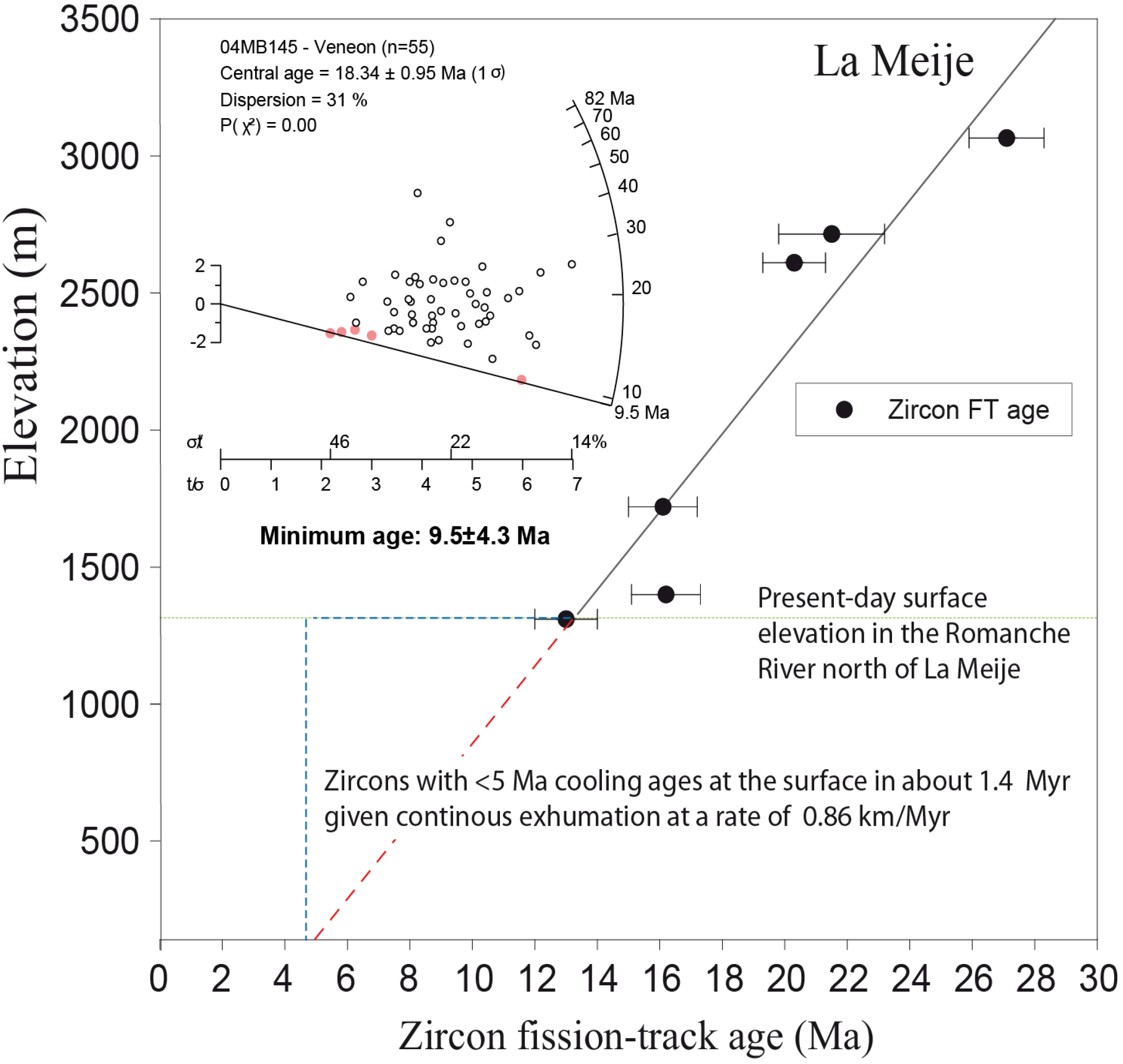
5. Results
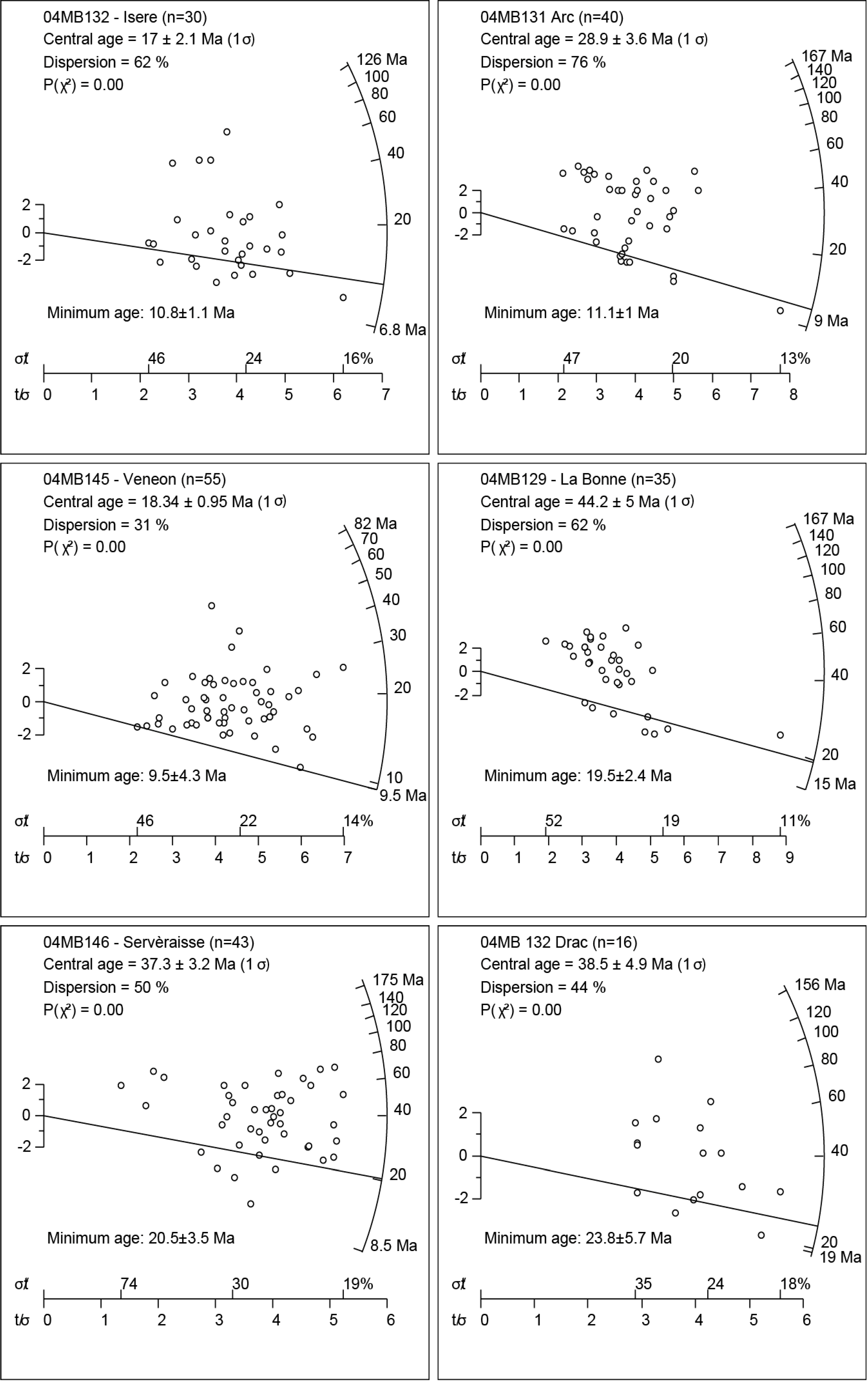
| Sample | N | ρs (t/cm−2) | Ns | ρi (t/cm−2) | Ni | ρd (t/cm−2) | P(χ2) | Grain age range (Ma) | Central age (Ma) | ±1σ | Minimum age (Ma) | ±1σ |
|---|---|---|---|---|---|---|---|---|---|---|---|---|
| Isére | 30 | 3.36 × 10⁶ | 1,224 | 2.58 × 10⁶ | 941 | 2.25 × 10⁵ | 0.0 | 6.9–122.9 | 17.0 | 2.1 | 10.8 | 1.1 |
| Arc | 40 | 4.31 × 10⁶ | 2,409 | 1.99 × 10⁶ | 1,113 | 2.26 × 10⁵ | 0.0 | 9.1–153.5 | 28.9 | 3.6 | 11.1 | 1.0 |
| Vénéon | 55 | 3.82 × 10⁶ | 2,661 | 2.89 × 10⁶ | 2,010 | 2.25 × 10⁵ | 0.0 | 9.7–80.9 | 18.3 | 1.0 | 9.5 | 4.3 |
| La Bonne | 36 | 5.41 × 10⁶ | 2,564 | 1.78 × 10⁶ | 846 | 2.27 × 10⁵ | 0.0 | 14.9–149.8 | 44.8 | 5.0 | 19.5 | 2.4 |
| La Sevèraisse | 43 | 4.41 × 10⁶ | 2,708 | 1.56 × 10⁶ | 955 | 2.24 × 10⁵ | 0.0 | 8.6–157.5 | 37.3 | 3.2 | 20.5 | 3.5 |
| Drac | 16 | 4.87 × 10⁶ | 1,031 | 1.73 × 10⁶ | 366 | 2.26 × 10⁵ | 0.0 | 19.2–150.1 | 38.5 | 4.9 | 23.8 | 5.7 |
| Merged samples * | 220 | 4.32 × 10⁶ | 12,597 | 2.15 × 10⁶ | 6,269 | 2.25 × 10⁵ | 0.0 | 6.9–157.7 | 26.8 | 1.2 | 12.19 | 0.64 |
| Isére at Chateauneuf ** | 100 | 5.19 × 10⁶ | 5,059 | 5.13 × 10⁶ | 5,007 | 2.34 × 10⁵ | 0.0 | 8.1–145.9 | 35.7 | 2.5 | 14.1 | 1 |

6. Discussion
6.1. Comparison with Published Detrital and Bedrock AFT and ZFT Data

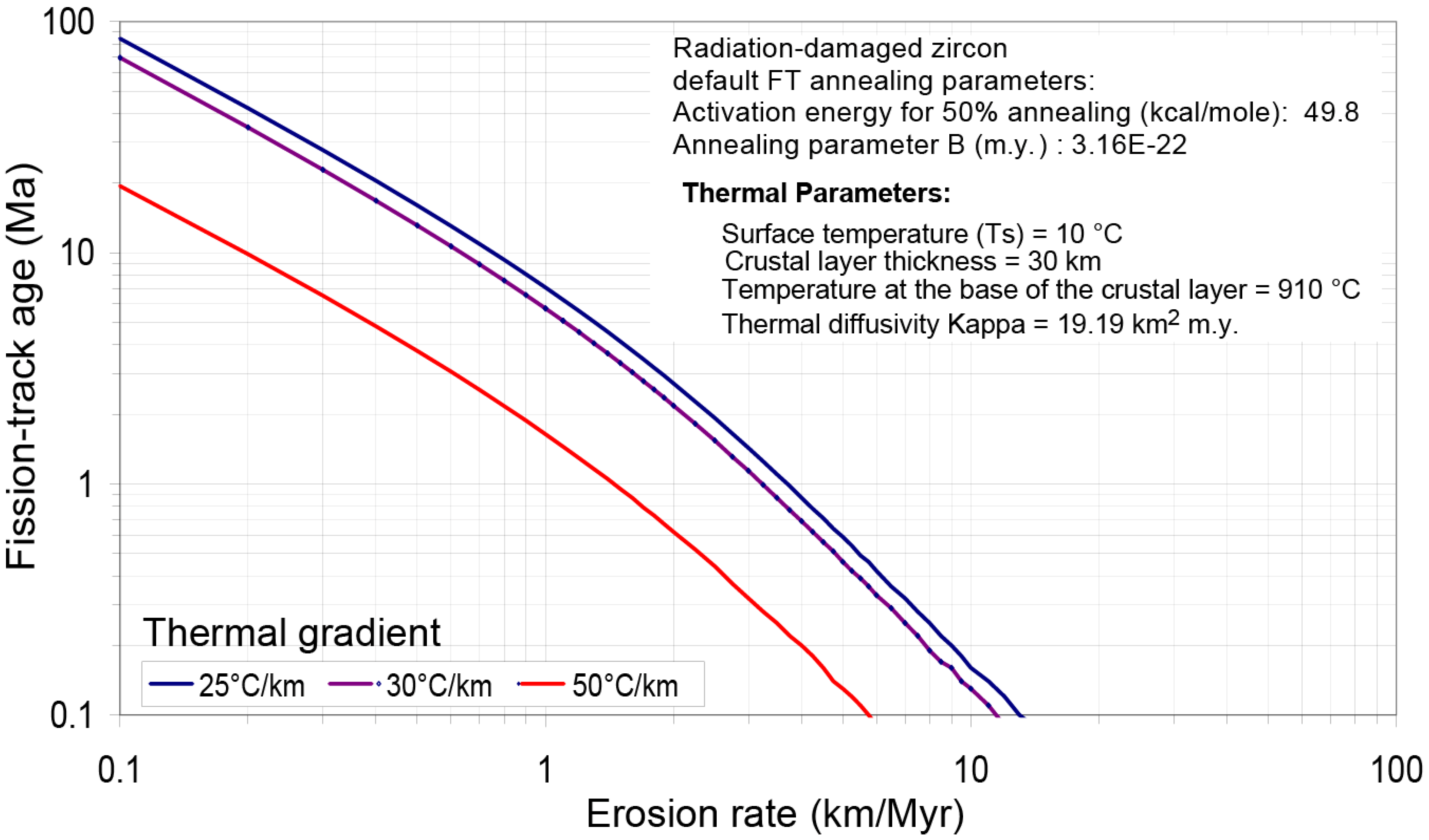
6.2. Exhumation Rate Estimates
6.3. Short-Term versus Long-Term Exhumation Signal
| River | Short-term estimate (km/Myr) from 10 Be analyses * | Long-term estimate (km/Myr) from ZFT central age | Long-term estimate (km/Myr) from ZFT minimum age |
|---|---|---|---|
| Vénéon | 0.86 ± 0.16 | 0.39 ± 0.08 | 0.65 ± 0.14 |
| La Bonne | 0.29 ± 0.06 | 0.18 ± 0.04 | 0.39 ± 0.08 |
| Séveraisse | 0.65 ± 0.12 | 0.19 ± 0.04 | 0.27 ± 0.06 |
| Drac | 0.67 ± 0.13 | 0.19 ± 0.04 | 0.30 ± 0.06 |
6.4. Increasing Erosion Rates at 5 Ma?
7. Conclusions
Acknowledgments
Conflict of Interest
References
- Carrapa, B. Tracing exhumation and orogenic wedge dynamics in the European Alps with detrital thermochronology. Geology 2009, 37, 1127–1130. [Google Scholar] [CrossRef]
- Carrapa, B. Tracing exhumation and orogenic wedge dynamics in the European Alps with detrital thermochronology—Reply. Geology 2010, 38, e227. [Google Scholar] [CrossRef]
- Bernet, M. Tracing exhumation and orogenic wedge dynamics in the European Alps with detrital thermochronology—Comment. Geology 2010, 38, e226. [Google Scholar] [CrossRef]
- Carrapa, B.; Wijbrans, J.; Bertotti, G. Episodic exhumation in the Western Alps. Geology 2003, 31, 601–604. [Google Scholar] [CrossRef]
- Morag, N.; Avigad, D.; Harlavan, Y.; McWilliams, M.O.; Michard, A. Rapid exhumation and mountain building in the Western Alps: Petrology and 40Ar/39Ar geochronology of detritus from Tertiary basins of southeastern France. Tectonics 2008, 27. [Google Scholar] [CrossRef]
- Bernet, M.; Tricart, P. The Oligocene orogenic pulse in the Southern Penninic Arc (Western Alps): Structural, sedimentary and thermochronological constraints. Bull. Soc. Géol. Fr. 2011, 182, 25–36. [Google Scholar]
- Jourdan, S.; Bernet, M.; Tricart, P.; Hardwick, E.; Paquette, J.L.; Guillot, S.; Dumont, T.; Schwartz, S. Short-lived fast erosional exhumation of the internal Western Alps, during the late Early Oligocene: Constraints from geo-thermochronology of pro- and retro-side foreland basin sediments. Lithosphere 2013, 5, 211–225. [Google Scholar] [CrossRef]
- Bernet, M.; Brandon, M.T.; Garver, J.I.; Balestrieri, M.L.; Ventura, B.; Zattin, M. Exhuming the Alps through time: Clues from detrital zircon fission-track ages. Basin Res. 2009, 21, 781–798. [Google Scholar] [CrossRef]
- Kuhlemann, J. Post-collisional sediment budget of circum-Alpine basins (Central Europe). Mem. Ist. di Geol. Min. Uni. Padova 2000, 52, 1–91. [Google Scholar]
- Kuhlemann, J.; Frisch, W.; Székely, B.; Dunkl, I.; Kázmér, M. Post-collisional sediment budget history of the Alps: Tectonic versus climatic control. Int. J. Earth Sci. 2002, 91, 818–837. [Google Scholar] [CrossRef]
- Cederbom, C.E.; Sinclair, H.D.; Schlunegger, F.; Rahn, M.K. Climate-induced rebound and exhumation of the European Alps. Geology 2004, 32, 709–712. [Google Scholar] [CrossRef]
- Vernon, A.J.; van der Beek, P.A.; Sinclair, H.D.; Rahn, M.K. Increase in late Neogene denudation of the European Alps confirmed by analysis of a fission-track thermochronology database. Earth Plan. Sci. Lett. 2008, 270, 316–329. [Google Scholar] [CrossRef] [Green Version]
- Willett, S.D. Late Neogene erosion of the Alps: A climate driver? Annu. Rev. Earth Plan. Sci. 2010, 38, 409–435. [Google Scholar] [CrossRef]
- Marine Geoscience Data System, Lamont-Doherty Earth Observatory. GeoMapApp, Version 3.3.6; Columbia University: Palisades, NY, USA, 2013. Available online: http://www.geomapapp.org/ (accessed on 1 February 2013).
- Platt, J.P.; Behrmann, J.H.; Cunningham, P.C.; Dewey, J.F.; Helman, M.; Parish, M.; Shepley, M.G.; Wallis, S.; Weston, P.G. Kinematics of the Alpine arc and the motion history of Adria. Nature 1989, 337, 158–161. [Google Scholar] [CrossRef]
- Sinclair, H.D. Flysch to molasse transition in peripheral foreland basins: The role of the passive margin versus slab breakoff. Geology 1997, 25, 1123–1126. [Google Scholar] [CrossRef]
- Schmid, S.M.; Fügenschuh, B.; Kissling, E.; Schuster, R. Tectonic map and overall architecture of the Alpine orogen. Ecl. Geol. Helv. 2004, 97, 93–117. [Google Scholar] [CrossRef]
- Schmid, S.M.; Kissling, E. The arc of the western Alps in the light of geophysical data on deep crustal structure. Tectonics 2000, 19, 62–85. [Google Scholar] [CrossRef]
- Graciansky, P.C.; Roberts, D.G.; Tricart, P. The Western Alps, from Rift to Passive Margin to Orogenic Belt: An Integrated Geoscience Overview; Developments in Earth Surface Processe Volume 14; Elsevier: Amsterdam, The Netherlands, 2010. [Google Scholar]
- Fügenschuh, B.; Schmid, S. Late stages of deformation and exhumation of an orogen constrained by fission-track data: A case study in the Western Alps. GSA Bull. 2003, 115, 1425–1440. [Google Scholar] [CrossRef]
- Van der Beek, P.; Valla, P.G.; Herman, F.; Braun, J.; Persano, C.; Dobson, K.J.; Labrin, E. Inversion of thermochronological age–elevation profiles to extract independent estimates of denudation and relief history—II: Application to the French Western Alps. Earth Plan. Sci Lett. 2010, 296, 9–22. [Google Scholar] [CrossRef]
- Seward, D.; Ford, M.; Bürgisser, J.; Lickorish, H.; Williams, E.A.; Meckel, L.D., III. Preliminary Results of Fission-Track Analyses in the Southern Pelvoux Area, SE France. In Memoria del Instituto dell Geoligia i Mineraligia di Universidad de Padova, Proceedings of 3rd Workshop on Alpine Geological Studies, Biella–Oropa, Italy, 29 September–1 October 1997; Gosso, G., Jadoul, F., Sella, M., Spalla, M.I., Eds.; Volume 51, pp. 25–31.
- Sabil, N. La Datation Par Traces De Fission: Aspects Méthodologiques et Applications Thermochronologiques en Contextes alpiNs et de Marge Continentale. Ph.D. Thesis, Université Joseph Fourier, Grenoble, France, 7 June 1995. [Google Scholar]
- Glotzbach, C.; Bernet, M.; van der Beek, P. Detrital thermochronology records changing source areas and steady exhumation in the Western and Central European Alps. Geology 2011, 39, 239–242. [Google Scholar] [CrossRef]
- Bernet, M.; Brandon, M.T.; Garver, J.I.; Molitor, B.R. Downstream changes in Alpine detrital zircon fission-track ages of the Rhône and Rhine Rivers. J. Sediment. Res. 2004, 74, 82–94. [Google Scholar] [CrossRef]
- Naeser, N.D.; Zeitler, P.K.; Naeser, C.W.; Cerveny, P.F. Provenance studies by fission track dating–etching and counting procedures. Nucl. Tracks Rad. Meas. 1987, 13, 121–126. [Google Scholar] [CrossRef]
- Bernet, M.; Brandon, M.T.; Garver, J.I.; Molitor, B.R. Fundamentals of Detrital Zircon Fission-Track Analysis for Provenance and Exhumation Studies with Examples from the European Alps. In Detrital Thermochronology—Exhumation and Landscape Evolution of Mountain Belts; Special Publication Volume 378; Bernet, M., Spiegel, C., Eds.; Geological Society of America: Boulder, CO, USA, 2004; pp. 25–36. [Google Scholar]
- Bernet, M.; Garver, J.I. Fission-Track Dating of Detrital Zircon. In Low-Temperature Thermochronology: Reviews in Mineralogy and Geochemistry; Reiners, P., Ehlers, T., Eds.; Minerlogical Society of America: Chantilly, VA, USA, 2005; Volume 58, pp. 205–238. [Google Scholar]
- Vermeesch, P. RadialPlotter: A Java application for fission track, luminescence and other radial plots. Radiat. Measur. 2009, 44, 409–410. [Google Scholar]
- Verrmeesch, P. On the visualization of detrital age distributions. Chem. Geol. 2012, 312–313, 190–194. [Google Scholar] [CrossRef]
- Galbraith, R.F.; Laslett, G.M. Statistical models for mixed fission track ages. Nucl. Tracks Radiat. Meas. 1993, 21, 459–470. [Google Scholar] [CrossRef]
- Press, W.H.; Teukolsky, S.A.; Vetterling, W.T.; Flannery, B.P. Numerical Recipes in FORTRAN, 2nd ed.; Cambridge University Press: New York, NY, USA, 1992. [Google Scholar]
- Willett, S.D.; Brandon, M. Some analytical methods for converting thermochronometric age to erosion rate. Geochem. Geoph. Geosys. 2013, 14. [Google Scholar] [CrossRef]
- Ehlers, T.A.; Chaudhri, T.; Kumar, S.; Fuller, C.S.; Willett, S.D.; Ketcham, R.A.; Brandon, M.T.; Belton, D.X.; Kohn, B.P.; Gleadow, A.J.W.; et al. Computational Tools for Low-Temperature Thermochronometer Interpretation. In Low-Temperature Thermochronology: Reviews in Mineralogy and Geochemistry; Reiners, P.W., Ehlers, T.A., Eds.; Minerlogical Society of America: Chantilly, VA, USA, 2005; Volume 58, pp. 205–238. [Google Scholar]
- Reiners, P.W.; Brandon, M.T. Using Thermochronology to understand orogenic erosion. Annu. Rev. Earth Planet. Sci. 2006, 34, 419–466. [Google Scholar] [CrossRef]
- England, P.; Molnar, P. Surface uplift, uplift of rocks, and exhumation of rocks. Geology 1990, 18, 1173–1177. [Google Scholar] [CrossRef]
- Delunel, R.; van der Beek, P.; Carcaillet, J.; Bourles, D.; Valla, P.G. Frost-cracking control on catchment denudation rates: Insights from in situ produced 10Be concentrations in stream sediments (Ecrins–Pelvoux massif, French Western Alps). Earth Plan. Sci. Lett. 2010, 293, 72–83. [Google Scholar] [CrossRef]
- Bernet, M.; Zattin, M.; Garver, J.I.; Brandon, M.T.; Vance, J.A. Steady-state exhumation of the European Alps. Geology 2001, 29, 35–38. [Google Scholar] [CrossRef]
- Schlunegger, F. Controls of surface erosion on the evolution of the Alps: Constraints from the stratigraphies of the adjacent foreland basins. Int. J. Earth Sci. 1999, 88, 285–304. [Google Scholar] [CrossRef]
- Zhang, P.; Molnar, P.; Downs, W.R. Increased sedimentation rates and grain sizes 2–4 Myr ago due to the influence of climate change on erosion rates. Nature 2001, 410, 891–897. [Google Scholar] [CrossRef]
- Willenbring, J.K.; von Blanckenburg, F. Long-term stability of global erosion rates and weathering during late-Cenozoic cooling. Nature 2010, 465, 211–214. [Google Scholar] [CrossRef]
- Braun, J. Pecube: A new finite-element code to solve the 3D heat transport equation including the effects of a time-varying, finite amplitude surface topography. Comp. Geosci. 2003, 29, 787–794. [Google Scholar] [CrossRef]
- Valla, P.G.; van der Beek, P.; Shuster, D.; Braun, J.; Herman, F.; Tassant-Got, L.A.; Gautheron, C. Late-Neogene exhumation and relief development of the Aar and Aiguilles Rouges massifs (Swiss Alps) from low-temperature thermochronology modeling and 4He/3He thermochronometry. J. Geoph. Res. Earth Surf. 2011, 295, 511–522. [Google Scholar]
© 2013 by the authors; licensee MDPI, Basel, Switzerland. This article is an open access article distributed under the terms and conditions of the Creative Commons Attribution license (http://creativecommons.org/licenses/by/3.0/).
Share and Cite
Bernet, M. Detrital Zircon Fission-Track Thermochronology of the Present-Day Isère River Drainage System in the Western Alps: No Evidence for Increasing Erosion Rates at 5 Ma. Geosciences 2013, 3, 528-542. https://doi.org/10.3390/geosciences3030528
Bernet M. Detrital Zircon Fission-Track Thermochronology of the Present-Day Isère River Drainage System in the Western Alps: No Evidence for Increasing Erosion Rates at 5 Ma. Geosciences. 2013; 3(3):528-542. https://doi.org/10.3390/geosciences3030528
Chicago/Turabian StyleBernet, Matthias. 2013. "Detrital Zircon Fission-Track Thermochronology of the Present-Day Isère River Drainage System in the Western Alps: No Evidence for Increasing Erosion Rates at 5 Ma" Geosciences 3, no. 3: 528-542. https://doi.org/10.3390/geosciences3030528