Article

Multi-Stage Deformation of the Khangalas Ore Cluster (Verkhoyansk-Kolyma Folded Region, Northeast Russia): Ore-Controlling Reverse Thrust Faults and Post-Mineral Strike-Slip Faults

by
Valery Y. Fridovsky
1,*,
Maxim V. Kudrin
1 and
Lena I. Polufuntikova
2
1
Diamond and Precious Metal Geology Institute, SB RAS, Yakutsk 677000, Russia
2
M.K. Ammosov North-Eastern Federal University, Yakutsk 677000, Russia
*
Author to whom correspondence should be addressed.
Minerals 2018, 8(7), 270; https://doi.org/10.3390/min8070270
Submission received: 4 May 2018 / Revised: 19 June 2018 / Accepted: 22 June 2018 / Published: 26 June 2018
(This article belongs to the Special Issue Structural Control of Mineral Deposits: Theory and Reality)

Abstract

:
This study reports the results of the analysis of multi-stage deformation structures of the Khangalas gold ore cluster, northeast Russia. Four Late Mesozoic-Early Eocene deformation stages were identified. The first deformation event (D1) was characterized by the development of NW-striking tight to isoclinal folds of the first generation (F1) and interstratal detachment thrusts. Major folds, extensive thrusts, boudinage, cleavage, auriferous mineralized fault zones and quartz-vein gold mineralization were formed in the reverse and thrust fault stress field during the progressive deformation stage (D1), with NE-SW-oriented σ1. Post-ore deformation is widely manifested in the region. Structures D2 and D3 are coaxial. Sinistral strike-slip motions (D2 and D3) occurred along NW-trending faults under prevailing W-E compression. They were accompanied by the formation of NS- and NE-striking F2–3 folds with steep hinges and by bending of the earlier formed structures, among them ore-controlling ones. The last deformation event (D4) was represented by normal-dextral strike-slip faulting, refolding of rocks, pre-existing structures and ore bodies and by the development of folds with steep hinges. Key structural elements of varying age are described, the chronology of deformation events and mineralization reconstructed and their relation to geodynamic events in northeast Asia established.

1. Introduction

The Khangalas ore cluster (KOC) is located in the southeastern part of the Kular-Nera slate belt of the Verkhoyansk-Kolyma folded region in northeast Russia. It was discovered in the 1940s. Rich placer deposits with large gold nuggets are known there. Commercial exploitation of the KOC commenced in the latter half of the 20th Century and continues to present day. At an early stage of geologic investigation (1940–1980), considerable attention was given to concordant ore bodies confined to the limbs of brachyanticlinal folds [1]. Then, in the late 1980s to the early 2000s, mineralized fault zones of complex structure with diverse mineralization were identified and investigated, which considerably enlarged the mineral resource potential of the KOC [2,3]. Southeasterly, in the Upper Kolyma gold district with a similar geological-structural setting, several small- and medium-sized gold deposits are found, such as Vetrenskoye, Chay-Yuruye, Svetloye, etc. [4,5]. Gold mineralization of the KOC is of the orogenic type, which is characterized by a close relationship with Late Jurassic-Neocomian tectonomagmatic events in the Verkhoyansk-Kolyma folded region [6,7,8,9,10]. The paper presents new data on the KOC geology obtained by the authors in the last few years, which provide a better understanding of the relations between folds, faults and mineralization in the region.

2. Materials and Methods

Structural-tectonic factors are among the most important in controlling localization of orogenic Au-quartz deposits [11,12]. Structural-kinematic studies in the Khangalas ore cluster were conducted using up-to-date methods [13,14,15,16,17]. The morphology of ore veins in natural exposures and mine workings was studied and their relations to geological structures established. Interactions between the veins and faults were studied using the belt method [18]. This is based on the regular position of vein poles relative to faults in stereographic projection. The method enables determination of the sense of displacement during vein formation [18]. Measurements of planar and linear structures (bedding, cleavage, vein-veinlet bodies, faults, ore zones, jointing, fold hinges, boudinage, slickenlines, etc.) were made. The kinematics of main deformation stages and the paleo-orientation of stress were reconstructed relative to major deformation structures of NW strike. Structural data were statistically analyzed and plotted on the upper hemisphere of the Wulff stereographic net.
In 2005, detailed field studies and structural mapping were conducted at the Nagornoye deposit and the Dvoinoye, Ampir and Klich-Kontrolnoye occurrences, at Mudeken and other localities and in 2014 and 2017 at the Khangalas deposit and Ozhidaniye occurrence. The nomenclature of structural elements is taken from [19]. Planar structures (S) are given as dip azimuth/dip angle (e.g., 90/60 denotes eastward dip at 60°). For linear deformation elements (l), denotation plunge azimuth/plunge angle is used (e.g., 215/45 means plunge azimuth of 215° and plunge angle of 45°). Signs S1 and l1 denote the relation of a structural element to a particular deformation stage (D1) event. The studies enabled refining the general architecture of the region, revealing the particularities of the ore-controlling structures, identifying key structural elements, reconstructing the chronology of deformational events and mineralization and establishing their relationship with regional geodynamic events in northeast Asia.

3. Geology of the Southeastern Part of the Kular-Nera Slate Belt and the Khangalas Ore Cluster

The Kular-Nera slate belt (KNSB) is situated in the central part of the Verkhoyansk-Kolyma folded region [6]. It is mainly composed of Upper Permian, Triassic and Lower Jurassic terrigenous rocks. Extensive faults separate the belt from adjacent tectonic structures. In the northeast, it is separated from the In′yali-Debin synclinorium by the Charky-Indigirka and Chai-Yureye faults, and in the southwest, the Adycha-Taryn fault separates it from structures of the passive margin of the North Asian craton. The structural pattern of KNSB is defined by linear folds and faults of NW strike that developed over several deformation stages. Within the KOC, NW-striking faults represent branches of the Nera Fault, which manifests itself as 4 km-wide zones of intensive deformations and subvertical foliation of the rocks. Dextral strike-slip motions have been reported along the Nera Fault [20].
Magmatism is poorly manifested in KNSB. It is mainly represented by granitoid massifs, subvolcanic magma of dacite composition and dikes belonging to the NNW-striking Tas-Kystabyt magmatic belt. They were formed in Late Jurassic-Albian times [21]. Various tectonomagmatic events characteristic of the Late Jurassic-Late Cretaceous history of the eastern margin of the North Asian craton are manifested within KNSB [6,22,23]. The Late Jurassic-Early Cretaceous was marked by accretion and collision of the Kolyma-Omolon microcontinent against the craton margin and by subduction processes in the Uda-Murgal island arc. These events produced different-age fold and thrust structures, S- and I-type granitoids and orogenic gold deposits. In the Late Neocomian, the direction of the Kolyma-Omolon microcontinent motion and of subduction in the Uda-Murgal arc changed [6]. At that time, left-lateral strike slip motions first occurred in KNSB along NW-trending faults. Post-accretionary tectonic events and Au-Sb and Ag mineralization events were related to Late Cretaceous subduction within the Okhotsk-Chukotka arc [24].
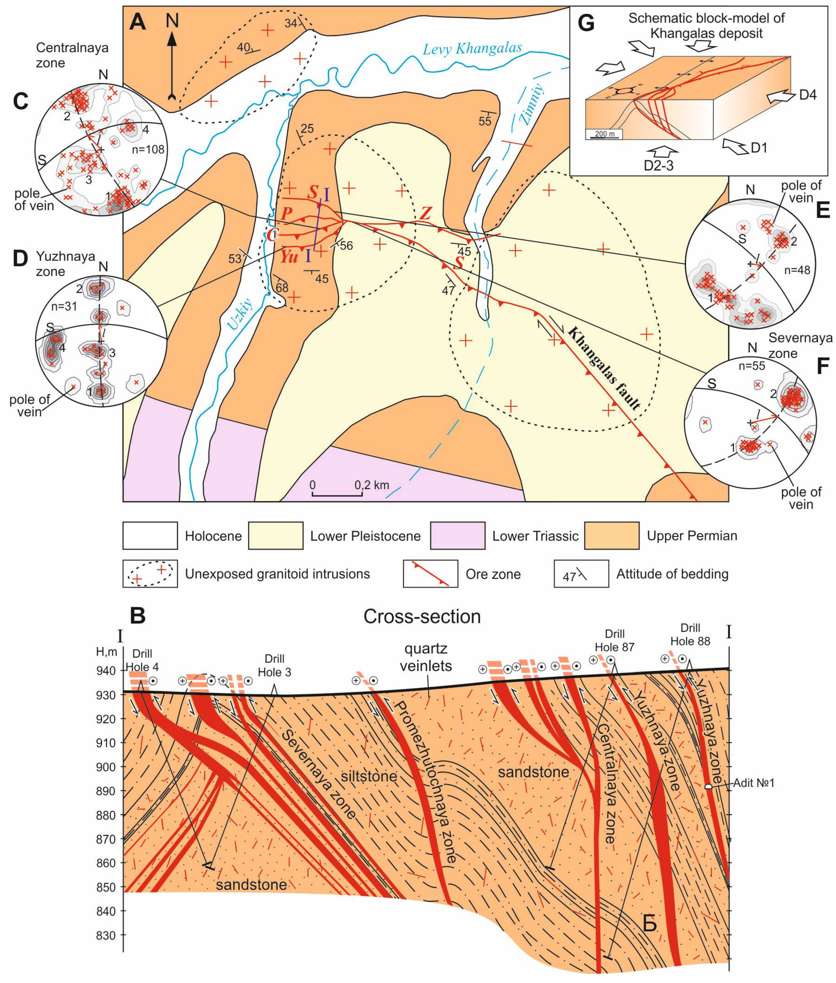
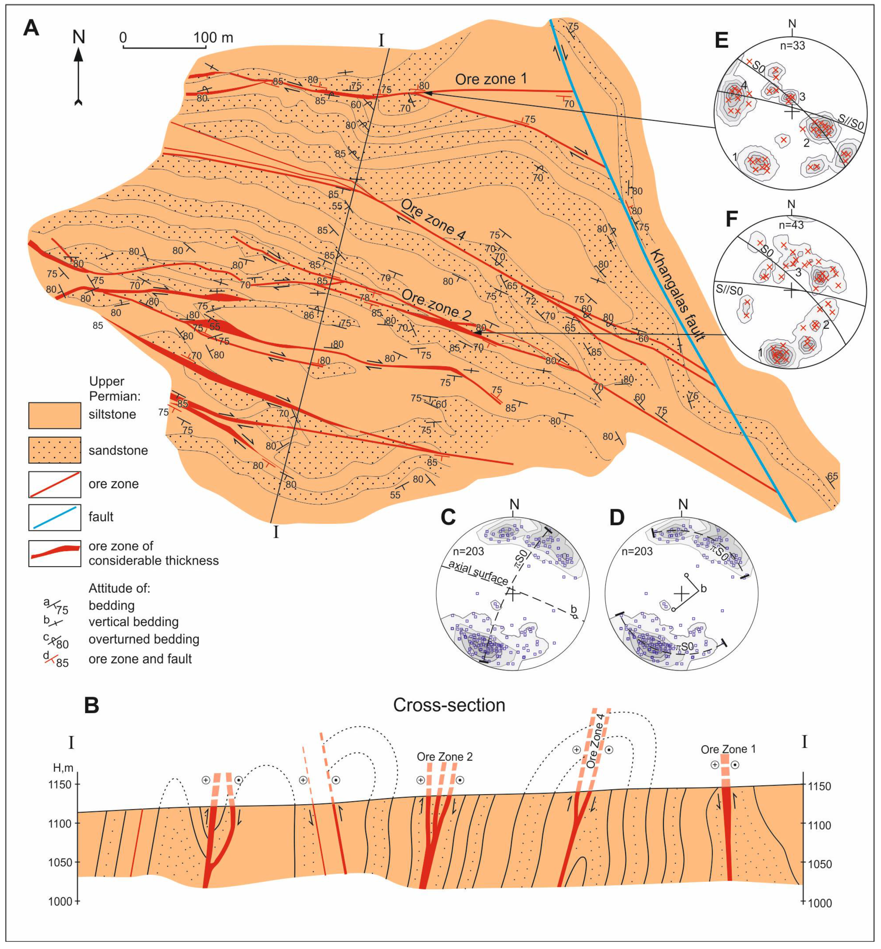
The Khangalas ore cluster is located in the arch of the Nera anticlinorium that is represented in the study area by the NW-striking Dvoinaya anticline composed of dislocated Upper Permian and Lower-Middle Triassic terrigenous rocks (Figure 1). The Upper Permian (P2) deposits make up the core of the Dvoinaya anticline. The lower part of the section consists of massive brownish-grey and grey greywacke sandstones with thin siltstone interbeds. The upper part is dominated by an 800 m thick sequence of dark-grey and black siltstones with inclusions of pebbles of sedimentary, magmatic and metamorphic rocks. The limbs of the Dvoinaya anticline are made of 680–750 m thick Lower-Middle Triassic deposits (T1), mainly dark-grey shales, mudstones and siltstones with rare interbeds of light-grey sandstones. The Middle Triassic deposits of the Anisian stage (T2a) are represented by a 700–800 m thick sequence of alternating sandy siltstones and siltstones with rare fine-grained sandstone interbeds. The Ladinian strata (T2l) are chiefly made of interbedded siltstones and sandstones with a total thickness of 850–950 m.
The main ore-controlling rupture dislocations are the Khangalas, Dvoinoy and Granitny faults represented by zones of breccia and fracture, low sulfidation of rocks and quartz-carbonate vein mineralization (Figure 1). The Khangalas Fault crosscuts the Khangalas ore cluster in a northwest direction. It controls localization of the Khangalas deposit and Ampir and Klich-Kontrolnoye occurrences. Within the study area, the exposed fault changes its strike from NW-SE to E-W and has a dip direction to S-W and S. The bedding of rocks exposed in the S-W wall strikes N-W, and rocks of the N-E wall strike NE-SW and E-W. The Dvoinoy Fault strikes E-W, and its fault plane is subvertical. In the central part of the KOC, northward of the Klich-Kontrolnoye occurrence, the Dvoinoy Fault adjoins the Khangalas Fault. The northeastern branch of the Dvoinoy Fault controls mineralization at the Nagornoye deposit. The rocks of the S wall of the fault have a N-E strike, while those of the N one strike E-W. The Granitny Fault is located in the southwestern part of the KOC. Outside the Khangalas ore cluster, the Ala-Chubuk massif of biotite granites is confined to it.
Magmatic activity is manifested by rare mafic and intermediate dikes of the normal and subalkaline series of Late Jurassic (Nera Complex (J3n)) and Late Cretaceous (Khulamrinsk Complex (K2ch)) age (Figure 1). The Nera magmatic complex includes basalt, gabbro and diorite porphyry dikes that extend for a distance from a few tens of meters to 2 km and have NE strike and a thickness of 1–20 m. The dikes underwent alteration. They contain quartz-carbonate veinlets. The Khulamrinsk magmatic complex consists of rare trachybasalt dikes extending for 200–500 m. They have a NW strike and are 1–10 m thick.
At 7 km to the northwest of the Khangalas ore cluster is the exposed Ala-Chubuk massif of biotite granites. The K-Ar age of the massif determined on orthoclase from porphyry phenocrysts is 145.0 ± 3.0 Ma and on biotite from the groundmass 149.0 ± 3.0 Ma [25]. The available geophysical data imply the presence of unexposed intrusions of similar composition at the Nagornoye and Khangalas deposits [25]. The Khangalas, Dvoinoye and Duk ore fields are identified within the KOC. The first field occurs in the southeast of the ore cluster and includes the Khangalas deposit and the Ozhidaniye occurrence. To the northwest of them are the Klich-Kontrolnoye, Dvoinoye and Ampir occurrences belonging to the Dvoinoye ore field. The Duk ore field includes the Nagornoye deposit. The ore bodies consist of extensive mineralized fault zones and concordant and cross-cutting gold-quartz veins and veinlets with simple mineral composition. The amount of ore minerals does not exceed 1–3%. These are arsenopyrite, pyrite, galena, sphalerite, chalcopyrite and native gold with 820–830‰ fineness and rare antimonite and Pb-sulfosalts. Quartz is the main gangue mineral, with less abundant carbonates (calcite and siderite) and chlorite. A series of successive mineral assemblages are identified in the ores of the deposits. These are pyrite-arsenopyrite-quartz metasomatic, quartz-pyrite-arsenopyrite vein, chalcopyrite-sphalerite-galena and sulfosalt-carbonate assemblages. The early pyrite-arsenopyrite-quartz mineralization is developed in wall-rock metasomatites. It is represented by irregular disseminations of pyrite and arsenopyrite metacrysts and by thin quartz streaks. Pyrite prevails over arsenopyrite. Minerals of the metasomatic assemblage are characterized by euhedral and subhedral crystals and a streaky-disseminated structure. Pyrite and arsenopyrite grains show evidence of deformation and corrosion. Pyrite and arsenopyrite of the early vein assemblage occur as disseminated euhedral grains and intergrowths. Pyrites of the vein assemblage contain Co, Sb, As, Ni, Cu and Zn trace contaminants. Minerals of the productive chalcopyrite-sphalerite-galena assemblage sporadically occur as disseminations and small aggregates in milk-white quartz and as microinclusions in early sulfides. The principal mineral of the sulfosalt-carbonate assemblage is siderite. Sulfosalts are represented by boulangerite, tetrahedrite and bournonite.
Microthermometric studies of the fluid were conducted at the laboratory of the M.K. Ammosov North-Eastern Federal University on an optical microscope AxioScope.Al fitted with a motorized heating stage (up to 600 °C) and a liquid nitrogen sample cooling system (down to −196 °C) (LNP95). Analyses were made on milk-white quartz samples from the ore veins. The results of thermo- and cryo-metric studies showed that ore-forming fluids of the KOC originated at temperatures of 310–330 °C and a pressure of 0.9 kbar. The data obtained suggest that gold mineralization was formed at a depth of about 3.5 km.
Age determinations are scarce for the KOC mineralization. The K-Ar sericite age of the Nagornoye deposit is 130.0 ± 4.0 Ma [23]. The authors of the given paper conducted Re-Os dating of gold (Sample Number X-45-14) from a quartz vein from the Yuzhnaya ore zone of the Khangalas deposit at the Center of Isotope Research of the Karpinsky All-Russian Scientific-Research Geological Institute (St. Petersburg, Russia). The isochron Re-Os age of gold was 137.0 ± 7.6 Ma. This indicates that productive orogenic gold-quartz mineralization of the region was formed in Valanginian-Hauterivian times.
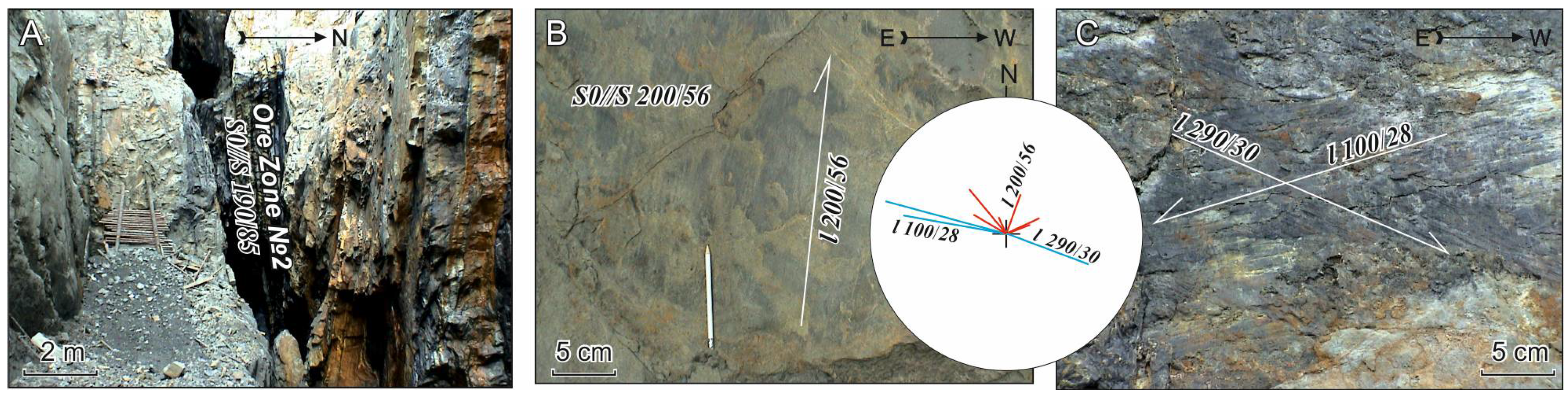
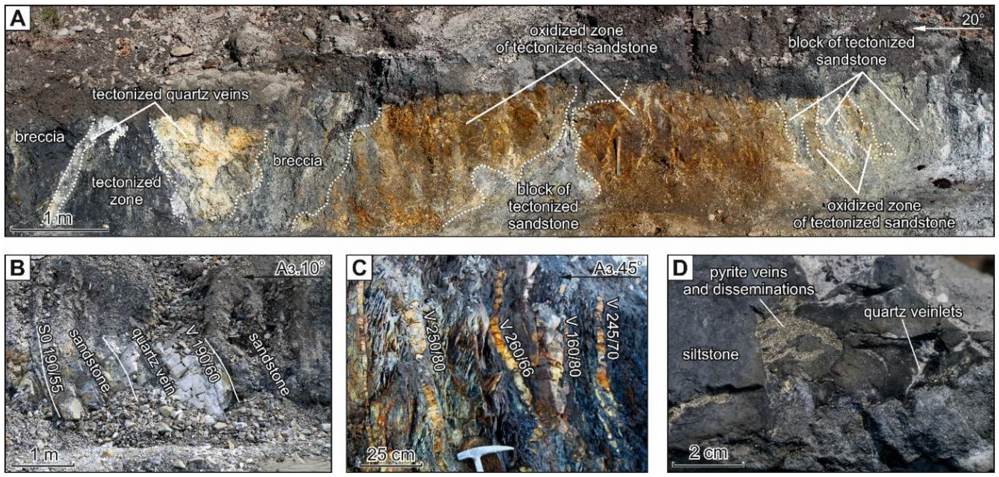
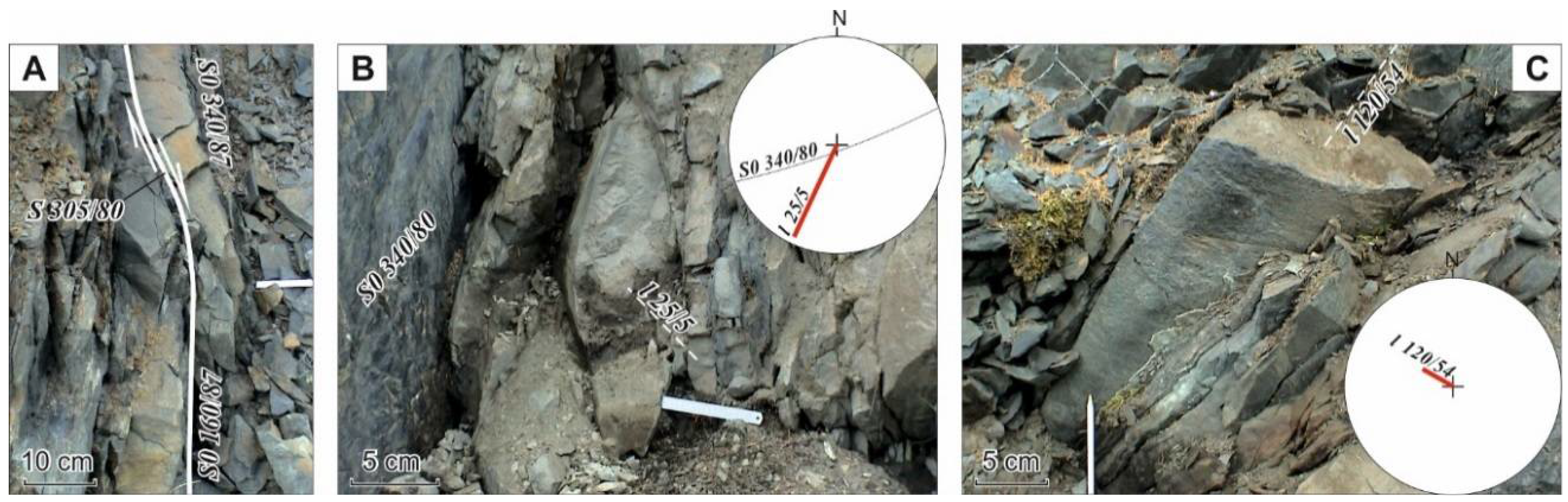
The mineralized brittle fault zones consist of breccias and blocks of quartzose sandstones and siltstones and are often accompanied by concordant (a few cm to 1–2 m thick, in swells up to 5 m) and cross-cutting quartz veins and veinlets and disseminated sulfide mineralization (Figure 2). They are mainly localized in sandstones and at their contacts with siltstones and have conformable and crossing relations with the host rocks. The ore zones underwent strong supergene alteration as indicated by the presence of Fe oxides, sulfates, clay minerals, etc. Nesterov N.V. [26] has reported on a secondary gold enrichment at the Khangalas deposit. The quartz veins are often deformed in the mineralized fault zones, which is indicative of post-ore deformation. The host siltstones and sandstones contain disseminated sulfide mineralization (Figure 2D) represented by fine to coarse crystalline arsenopyrite and pyrite occurring as crystals, nests and veinlets.

4. Deformation Structures of Key Deposits and Localities of the Khangalas Ore Cluster

This section presents the results of the analysis of the deformation structures of accretionary-collisional and post-accretionary stages in the formation history of the Khangalas and Nagornoye deposits, Dvoinoye occurrence and Mudeken locality.

4.1. Khangalas Deposit

The deposit occurs in the southeastern part of the KOC, on the right bank of Levy Khangals Creek, in the area between its Uzkiy and Zimniy tributaries (Figure 1). The host rocks are represented by Upper Permian sandstones and, more rarely, siltstones. Mineralization is localized in five fault zones (Severnaya, Promezhutochnaya, Centralnaya, Yuzhnaya and Zimnyaya, length up to 1400 m) with concordant and cross quartz veins 0.1–5 m thick in the crest of the Dvoinaya anticline (Figure 3 and Figure 4). Ore zones with a thickness of up to 32 m dip S-W, S and S-E at 30–50° to 70–80°. The reserves exceed 11 tons of gold with an average grade of 11.2 g/t Au [27].
Various deformation structures are manifested at the Khangalas deposit (Figure 3 and Figure 4). Early isoclinal and tight concentric folds (F) with N-W strike and subhorizontal hinges (b) occur in narrow (up to a few tens of meters) zones (Figure 4D). In the study area, such folds were first mapped on the northeast limb of the Nera anticlinorium, in the zone influenced by the Chay-Yureye Fault [8]. Early folds are draped during progressive deformation into late folds, so that crests of late folds can often be seen on the limbs of early folds (Figure 4C). F1 folds are the most widespread in the KOC area; they have NW-SE strike and gentle hinges (b1) (Figure 4A). These are for the most part open folds that pass into tight ones nearby the fault zones. On the right side of Uzkiy Creek, folds and ore zones have E-W and, less frequently, N-E strike due to superimposed strike-slip deformation. F1 folds are accompanied by Cl cleavage (Figure 4). It is platy, rarely shelly-platy, and its intensity depends on the rock composition. The most intense cleavage is observed in siltstones, whereas in sandstones, it becomes coarse-platy. Its regional NW strike changes to NE-SW and E-W in areas of superposed strike-slip deformation.
The Severnaya mineralized zone is the most extensive one. On the western side of the Khangalas deposit, the Promezhutochnaya, Centralnaya and Yuzhnaya zones branch off from the Severnaya zone forming a horse tail termination structure, and on the eastern side, the Zimnyaya zone diverges from it in the E-W direction. The ore-controlling structures are confined to the core of the Dvoinaya anticlinal fold. The strike of the ore zones varies from NW-SE to S-W and, locally, to NE-SW.
Analysis of the attitude of quartz veins and veinlets revealed five variously-oriented systems (Figure 2 and Figure 3). Veins of the first system have persistent parameters; they are conformable with the host rocks (Figure 2B,C and Figure 3). Quartz veins of the second system follow the orientation of the bedding plane and ore zones, but they dip in the opposite direction. Low-angle veins of the third system localized in tension fractures in sandstones are rather common. The orientation of the fourth vein system is normal to the strike of mineralized faults. In some areas, all five systems of veins and veinlets are present, which form stockworks. Such systems of quartz vein mineralization, which are related to the reverse and thrust fault stress field, are also found at other gold deposits in the central part of the Kular-Nera slate belt (Bazovskoye, Malo-Tarynskoye, Levoberezhnoye and Sana) [7,28,29,30,31,32].

4.2. Nagornoye Deposit

The deposit is located in the northwestern part of the KOC within the Duk ore field (Figure 5). Ore bodies are between bedding planes within faults of an ESE-WNW trend. In some places, the fault zones are accompanied by concordant (up to 100 m in extent) and feathering quartz veins and veinlets (Figure 5E,F). The faults have reverse fault and strike-slip kinematics. The thickness of ore zones on the Nagornoye deposit varies from 0.6 to 3–4 m (average 1.0 m). Ore minerals include native gold, pyrite, arsenopyrite, Fe-gersdorffite, galena, sphalerite, chalcopyrite, tetrahedrite, bournonite and the rutile-group minerals [33]. They constitute up to 3% of the veins’ volume. The host rocks are mostly represented by Upper Permian sandstones with siltstone interbeds. They have an ESE-WNW strike and a steep (70–75°) to vertical, sometimes overturned bedding. They are deformed into ESE-WNW F folds with horizontal b hinges in which limbs with NNE-striking open folds with steep hinges have developed (Figure 5C,D).
The most extensively studied is Ore Zone 2 (Figure 5 and Figure 6A). It is exposed over much of its length in a mining trench, where it parallels a subvertical sequence of quartzy sandstones interlayered with siltstones (Figure 6A). Statistical analysis of the attitude of quartz veins showed that on the diagrams, fields of poles of veins are grouped, in spite of their significant scatter, along the great circle arcs corresponding to the projection of mineralized ore zones (S) (190/85) conformable with the rock bedding (S0) (Figure 5E,F). This indicates that feathering veins are mainly localized in extension fractures oriented at an obtuse angle to ore-bearing structures. Concordant veins of the first system are common (Figure 5E,F).
Variously-oriented slickenlines are established (Figure 6B). One can observe subvertical slickenlines (l-178/81) of the early thrust-faulting stage of deformation on E-W fault planes (Figure 6B). Strike slip accretionary slickenlines are manifested at the contacts of ore bodies (Figure 6C). These structural elements are associated with low-amplitude zones of warping observed on the northern wall of a trench that exposed Ore Zone 1. The axes of the warping zones plunge to SE (120/59) and are orthogonal to (l-290/30).

4.3. Dvoinoye Occurrence

The occurrence is located on the left side of the valley of Dvoinoy Creek (Figure 1). The host rocks are dominantly Late Permian sandstones with lesser siltstones. The ore bodies are represented by mineralized fault zones with quartz veins and veinlets ranging from 0.3–1.8 m (average 1.0 m) in thickness. The gold grade varies from 0.5–30.7 g/t Au.
At Dvoinoye, one can observe two systems of boudinage-structures on the limbs of folds (Figure 7). The first system is characterized by a subhorizontal long axis (Figure 7B), and the second system plunges to SE (120/54) (Figure 7C).

4.4. Mudeken Locality

Mudeken is located on the right side of the same name creek, ~6 km upstream from the Dvoinoy Creek mouth (Figure 1). Two faults and several folds are seen in an exposure of interlayered sandstones and siltstones along the creek bank (Figure 8). Fault S (77/60) is made of brecciated siltstones and sandstones with quartz veinlets. Two shelly-platy cleavages are manifested in its walls. The first Cl cleavage dips to W (265/80) and is subconformable with S0 (278/50). The second Cl cleavage dips gently to SE (130/35–49) following the strike of fault S (160/40), which is traced by an 8 cm thick quartz-carbonate vein of banded structure. In the lying and hanging walls of the fault are observed several en echelon systems of quartz-carbonate veins: V-SE (220–260/55), V-NE (75/80) and V-SE (136/42). Kinematic reconstructions of the vein systems revealed their relation to dextral strike-slip motions (Figure 8H).
To the east, in the footwall of S fault, one can observe widely developed folds with the axial planes conformable with the fault plane. The folds are asymmetric, with gentle and extensive SE limbs and steeper SW limbs; commonly, they are overturned due to dextral strike-slip motions along the bedding plane (Z-shaped folds) (Figure 8D). Bedding poles measured on the fold limbs form a belt along the great circle arc, which is characteristic of cylindrical folds (Figure 8F). Fold hinges (b) mostly dip S-SE at 35–60°. Early cleavage (Cl) is deformed in folds (Figure 8G). The cleavage poles presented in Figure 8G show that early cleavage was deformed during dextral strike-slip motions.

5. Discussion

Structural-kinematic analysis of deformation elements within the KOC revealed specific structures of deposits and occurrences. 
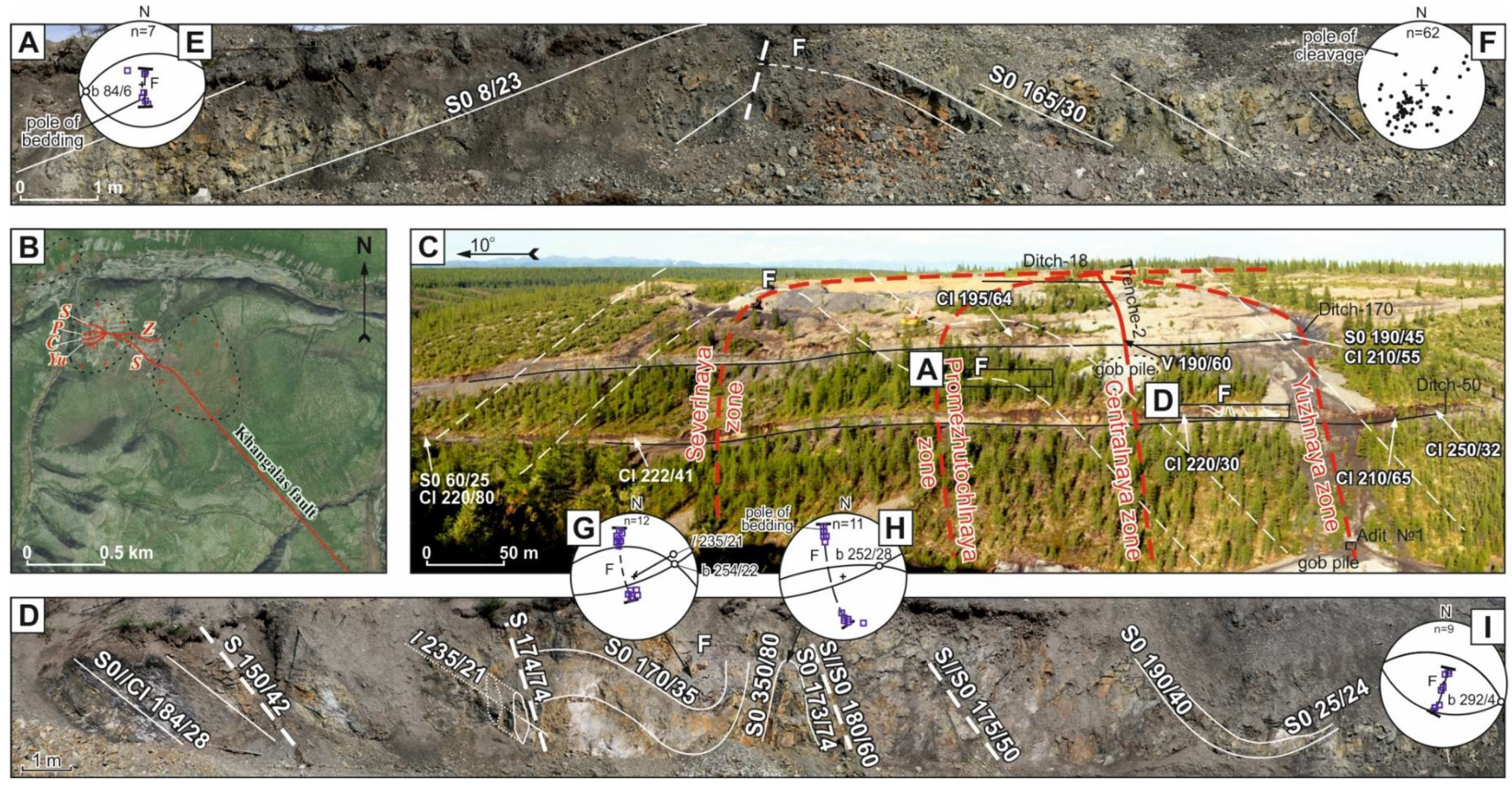
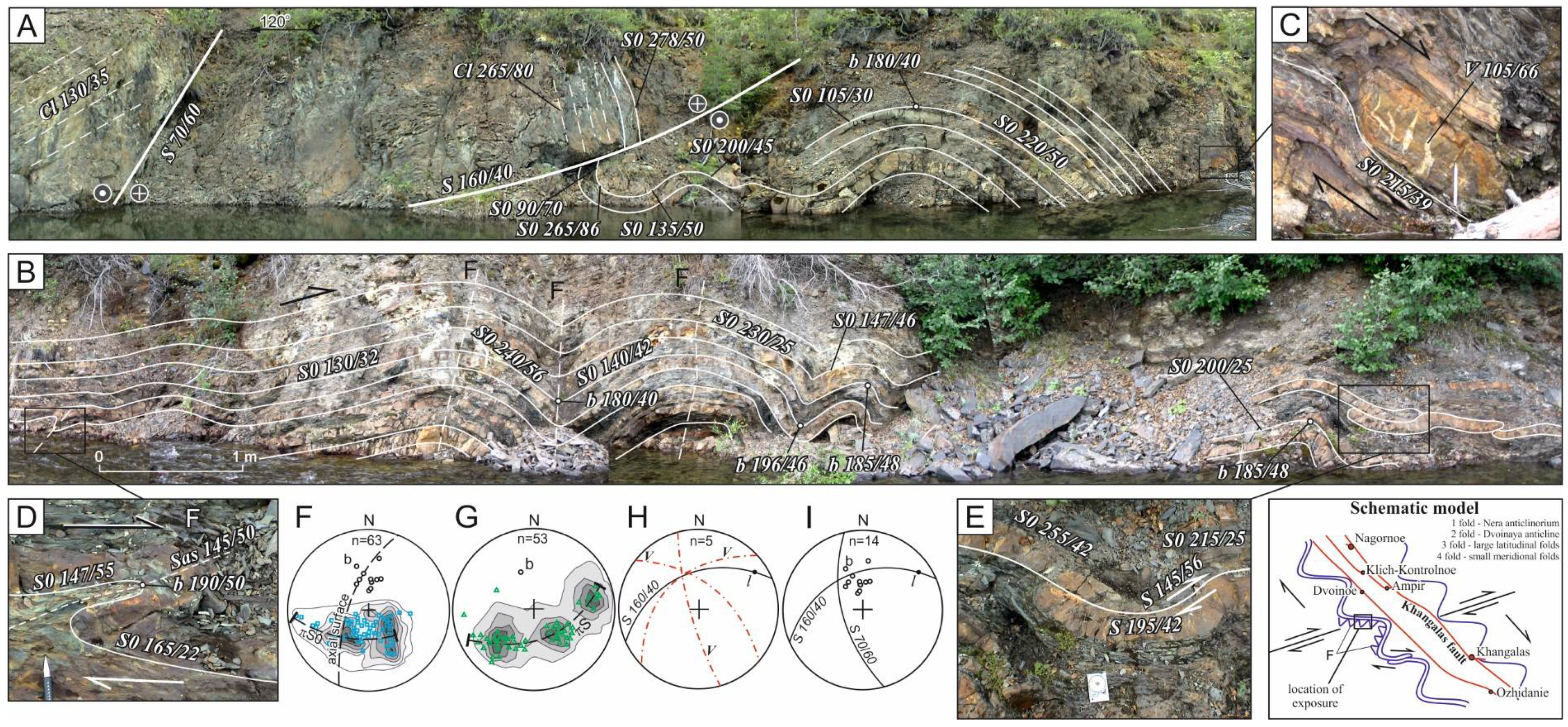
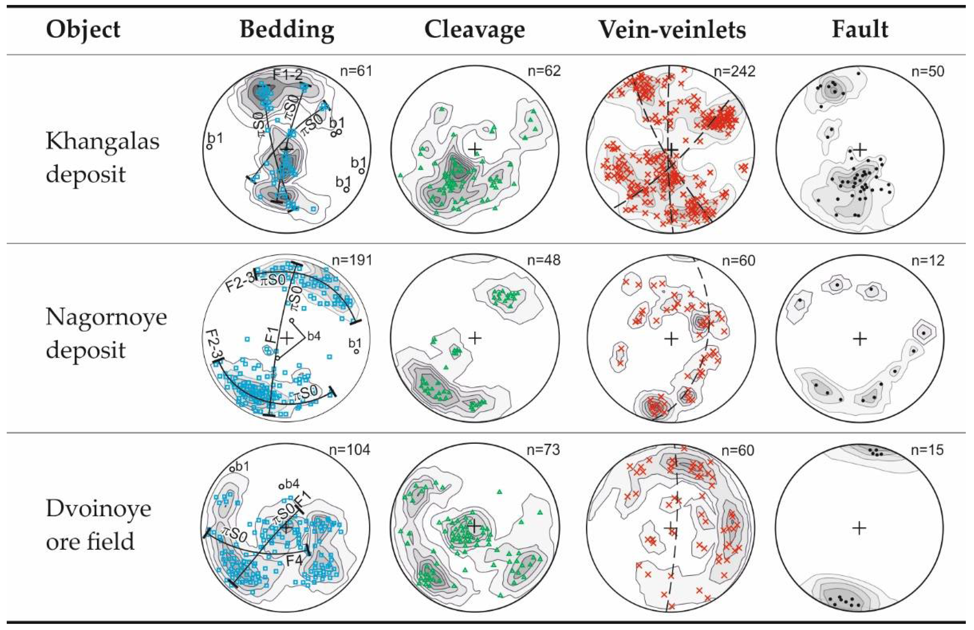
Figure 9 shows stereograms of major structural elements of the KOC (bedding, cleavage, quartz veins and veinlets, as well as mineralized fault zones). Fold structures of the Khangalas deposit have NW-SE to E-W strike. Fold hinges (b1) dip to WSW at angles varying from 4–28°. Steep dip angles are due to superposed strike-slip deformations. Hinges of the third order F1 folds smoothly undulate in the direction of NW regional folding within the Nera anticlinorium. Cl1 cleavage at the Khangalas deposit has a NW-SE strike. In the fault zones, cleavage is deformed by late strike-slip faulting, as well as bedding. In stereographic projections, poles of quartz veins and veinlets are arranged along subvertical belts. From the aforesaid, it appears that the formation of auriferous quartz veins and veinlets is related to major fold and thrust deformations of D1 stage (J3-Knc). Faults and ore zones at the Khangalas deposit have sublatitudinal and, more rarely, northeast and northwest strike. The majority of them dip S at 30–60°.
F1 compressed folds of sublatitudinal strike are deformed, like Cl1 cleavage at the Nagornoye deposit, by late strike-slip faults. This led to the formation on the limbs of F1 folds of F4 open folds with steep (b4) hinges plunging to NNE and SSW. On the stereogram, vein bodies form a steeply-dipping belt of poles. Faults and ore zones are, for the most part, interstratal and have latitudinal to NE-SW, rarely NW-SE orientation.
Bedding of rocks in the Dvoinoy ore field is characterized by NW-SE and NE-SW strike related to two different deformation stages: D1 and D4, respectively. Cleavages of NW-SE and E-W orientation are recognized. The first cleavage Cl1 is associated with the D1 stage. It was formed in relation to early fold-and-thrust dislocations. Cleavage Cl4 is related to the right-lateral strike-slip stage (D4). Fault zones within the Dvoinoye ore field have mostly WNW-ESE strike.
The results of studying other deposits within the Kular-Nera slate belt [22,31,32,33,34,35,36] in combination with the available information on the general tectonic and metallogenic evolution of the Verkhoyansk-Kolyma folded region [6,7,9,37] and the data on the relationships between the mapped structural elements obtained in this study indicate that deformation occurred in four stages: D1, D2, D3 and D4 (Table 1).
D1 and D2 deformations occurred in the Late Jurassic-Early Cretaceous in response to frontal (D1) and then oblique (D2) accretion of the Kolyma-Omolon microcontinent to the North Asian craton margin, as well as subsynchronous subduction-related processes within the Uda-Murgal active margin. The first Late Jurassic deformation event (D1) is characterized by development of NW-trending tight and isoclinal folds (F1), interstratal detachment thrusts at the contacts of rocks with contrasting physical-mechanical properties and ramps. The sense of tectonic transportation is SW. Mineralization consists of rare non-auriferous quartz-chlorite or quartz-chlorite-calcite veins occurring throughout the area. The thickness of the veins does not exceed a few tens of centimeters. Often, the veins are concordant with the host rock bedding.
During subsequent progressive deformation, the early interstratal detachment thrusts are deformed into reverse faults. Thrust deformations are associated with linear open and tight folds (F1) of the concentric type with prevailing NW-SE strike and platy cleavage. Within the ore zones, F1 folds form bands of intense deformation up to a few hundreds of meters wide. On the limbs of F2 folds, one can observe rootless intrafolio fold hinges of the early F1 folds [8] and slickenlines oriented in the direction of dip. This stage was marked by the origination of orogenic ore-magmatic systems and intrusion of granitoids and mafic and intermediate dikes of the Late Jurassic Nera complex, which produced vein, vein-veinlet and veinlet-disseminated gold-quartz (gold-sulfide-quartz) mineralization. According to the mineralogical data, mineralization was formed at a depth of about 3.5 km. The ore bodies are localized in mineralized fault zones, in the crests of folds (saddle veins) and sandstone strata (vein-veinlet bodies).
D2: The Late Neocomian is the period when the direction of motion of the Kolyma-Omolon microcontinent and of subduction in the Uda-Murgal arc began changing [6]. Within the Kular-Nera slate belt, the second stage of accretion (Aptian, Lower-Cretaceous) is characterized by the first left-lateral strike-slip motions (D2) on NW-striking faults, which occurred under prevailing W-E compression. At that time, intrusions of subvolcanic granite-porphyry were formed [24]. Strike-slip deformations reworked hydrothermal-metamorphogenic and gold-quartz (gold-sulfide-quartz) mineralizations causing their corrosion and remobilization, as well as the dynamic metamorphism of ore bodies. In association with strike-slip faults, F2 open folds were formed. The width of the mapped folds ranges up to a few hundred meters, but wider folds are likely, as well. Fold hinges plunge to N-E and N. At the contacts of mineralized fault zones, one can see variously-oriented subhorizontal slickenlines superposed on vertical ones.
D3: Post-accretionary tectonic events are associated with Late Cretaceous subduction in the Okhotsk-Chukotka arc [6,24]. This stage is marked by the formation of N-S and NE-SW folds (F3) with steep hinges and by activation of earlier structures, including ore-controlling ones. Note the similar kinematics of D2 and D3 deformations. F3 folds have various morphologies: from open symmetric to tight overturned ones. Characteristic are sinistral motions most widely manifested along the axial part of the Adycha-Taryn Fault [36].
At that stage, gold mineralization was superposed by Late Mesozoic antimony mineralization [24]. As shown in [36], a strong influence of Sb-bearing fluid caused significant reworking of the mineral complex of gold mineralization in the Adycha-Taryn zone. Formation of Sb mineralization was related to leaching and replacement processes that led to the formation of new mineral parageneses. Quartz-sericite metasomatites of the gold ore stage are characterized by the superposed late carbonate-paragonite-pyrophyllite-dickite paragenesis. Pyrite and arsenopyrite metacrysts are replaced by a mixture of antimonite and pyrophyllite. In the ore zones, late ore deposition is manifested by berthierite and antimonite. They form numerous streaks in milk-white quartz cementing its fragments and forming brecciated zones. The broken down milk-white quartz is freed from impurities along the fluid conductors. Solution occurs along the quartz grain boundaries. Transparent regenerated quartz forms streaks and aggregates of small (up to 1–2 mm) prismatic crystals, with pyramidal terminations. The early sulfides and sulfosalts also underwent intensive corrosion, leaching and redeposition, which led to the formation of an association of regenerated minerals. Microcrystals of the regenerated high-fineness (900–1000%) gold are often surrounded by reaction rims of aurostibite and antimony gold (Sb up to 8%) [36].
D4: The latest and fourth deformation event (D4) is characterized by dextral strike-slip faulting, refolding of rocks, reactivation of the earlier ore-controlling structures, as well as the formation of E-W folds and cleavage. Maastrichtian-Early Eocene strike-slip deformation is inferred to be related to oblique subduction of the Pacific Ocean plates beneath the eastern margin of north Asia [6] and/or to the formation of a transform margin in northeast Asia [38].

6. Conclusions

Studies of deformation structures of the Khangalas gold-ore cluster showed that they were forming over a long time during the course of the Late Jurassic-Neocomian accretionary and Late Cretaceous-Early Paleocene post-accretionary events in the Verkhoyansk-Kolyma folded region.
The first deformation event (D1) was characterized by the development of NW-striking tight to isoclinal folds of the first generation (F1) and interstratal detachment thrusts. Major folds, extensive thrusts, boudinage, cleavage, Au-bearing mineralized fault zones and quartz-vein mineralization were formed in the conditions of the tectonic stress field characteristic of reverse and thrust faulting, with the horizontal σ1 and vertical σ3. The D1 stage was progressive deformation under a contractional regime. In the zones of regional faults, where deformations are most intensely manifested, inter- and intra-stratal reverse and thrust faults developed in sandstones and at their contacts with siltstones, which were accompanied by intense, small-scale folding. These were favorable structural conditions for localization of mineralized fault zones with concordant and cross Au-quartz veins.
Post-ore deformations are widely manifested within the KOC. The D2 and D3 structures are co-axial. Sinistral strike-slip motions (D2–3) occurred along NW-striking faults. Associated with them were submeridional and NE-trending folds (F2–3) with steep hinges, as well as warping of the earlier, including ore-controlling, structures. The sinistral strike-slip stage is poorly manifested within the KOC, but its presence is established from the analysis of fractures, slickenlines and fault-line folds. Faults of NE strike can also be assigned to this structural paragenesis. It is likely that sinistral strike-slip deformations changed to dextral ones that are strongly manifested within the KOC.
The fourth event (D4) is represented by normal-dextral strike-slip motions, refolding of rocks, earlier structural elements and ore bodies. At this stage, latitudinal structures (F4 folds, Cl4 cleavage and S4 faults) were formed, which are more widespread here than in other metallogenic zones of the Upper Indigirka district (Adycha-Taryn, Mugurdakh-Selerikan). It is assumed that large-scale dextral strike-slip faults modified the structure of deposits and occurrences in the KOC. In the most strongly-deformed areas, the strike of the structures changed to sublatitudinal and, more rarely, to NE (Khangalas deposit). Ore zones of the Khangalas deposit were previously considered as “horse tail” structures [2], but detailed analysis of the relationships between auriferous quartz veins, ore zones and rock bedding permitted assigning them to the first-stage paragenesis (D1). The large scale and long duration of post-ore strike-slip motions can be inferred from the observation that early Au-bearing quartz veins are ground to “quartz flour” in the zones of later strike-slip faults. Also observed are quartz breccias in which early milk-white quartz is cemented by later chalcedony-like grey quartz typical for Ag-Sb mineralization known from the Verkhoyansk-Kolyma folded region [39,40].
Thus, it can be concluded that tectogenesis within the Verkhoyansk-Kolyma folded region followed a regular change from the Late Jurassic-Neocomian frontal accretionary regime to the Aptian-Early Eocene strike-slip regime and that gold mineralization was related to orogenic processes, as is exemplified by the Khangalas ore cluster described in this article.

Author Contributions

Idea of the study conceived by V.Y.F. Collection of field materials by V.Y.F., M.V.K. and L.I.P. Treatment of data and writing the text of the paper by V.Y.F. and M.V.K. Figure drawing by M.V.K.

Funding

This research was funded by Diamond and Precious Metal Geology Institute, Siberian Branch of the Russian Academy of Sciences, project number [No. 381-2016-004] and by Russian Foundation for Basic Research, grant number [No. 18-35-00336].

Conflicts of Interest

The authors declare no conflicts of interest.

References

  1. Rozhkov, I.S.; Grinberg, G.A.; Gamyanin, G.N.; Kukhtinskiy, Y.G.; Solovyev, V.I. Late Mesozoic Magmatism and Gold Mineralization of the Upper Indigirka District; Nauka: Moscow, Russia, 1971; p. 238. (In Russian) [Google Scholar]
  2. Oxman, V.S.; Suzdalova, N.I.; Kraev, A.A. Deformation Structures and Dynamic Conditions for the Formation of Rocks in Upper Indigirka District; Yakut Scientific Center Siberian Branch of the Russian Academy of Sciences: Yakutsk, Russia, 2005; p. 200. ISBN 5-463-00128-6. (In Russian) [Google Scholar]
  3. Fridovsky, V.Y.; Kudrin, M.V. Deformation structures of the Khangalas ore cluster. In Proceedings of the All-Russian Scientific-Practical Conference Geology and Mineral Resources of Northeast Russia, Yakutsk, Russia, 31 March–2 April 2015; pp. 537–540. (In Russian). [Google Scholar]
  4. Voroshin, S.V.; Tyukova, E.E.; Newberry, R.J.; Layer, P.W. Orogenic gold and rare metal deposits of the Upper Kolyma District, Northeastern Russia: Relation to igneous rocks, timing, and metal assemblages. Ore Geol. Rev. 2014, 62, 1–24. [Google Scholar] [CrossRef]
  5. Petrov, O.V.; Morozov, A.F.; Mikhailov, B.K.; Orlov, V.P.; Militenko, N.V.; Mezhelovsky, N.V.; Feoktistov, V.P.; Shatov, V.V.; Molchanov, A.V.; Migachev, I.F.; et al. Mineral Potential of the Russian Federation; Petrov, O.V., Ed.; FSBI A.P. Karpinsky Russian Geological Research Institute: St. Petersburg, Russia, 2009; p. 223. ISBN 978-5-93761-156-7. (In Russian) [Google Scholar]
  6. Tectonics, Geodynamics, and Metallogeny of the Sakha Republic (Yakutia) Territory; Parfenov, L.M.; Kuzmin, M.I. (Eds.) MAIK Nauka/Interperiodika: Moscow, Russia, 2001; p. 571. ISBN 5-7846-0046-X. (In Russian) [Google Scholar]
  7. Fridovsky, V.Y.; Prokopiev, A.B. Tectonics, geodynamics and gold mineralization of the eastern margin of the North Asia Craton. In The Timing and Location of Major Ore Deposits in an Evolving Orogen; Blundel, D.J., Neuber, F., von Quadt, A., Eds.; Geological Society: London, UK, 2002; Volume 204, pp. 299–317. [Google Scholar]
  8. Fridovsky, V.Y.; Polufuntikova, L.I.; Solovyev, E.E. Dynamics of the formation and structures of the southeastern sector of the Adycha-Nera metallogenic zone (northeast Yakutia). Russ. J. Domest. Geol. 2003, 3, 16–21. (In Russian) [Google Scholar]
  9. Fridovsky, V.Y. Structural control of orogenic gold deposits of the Verkhoyansk-Kolyma folded region, northeast Russia. Ore Geol. Rev. 2017, in press. [Google Scholar] [CrossRef]
  10. Goryachev, N.A.; Pirajno, F. Gold deposits and gold metallogeny of Far East Russia. Ore Geol. Rev. 2014, 59, 123–151. [Google Scholar] [CrossRef]
  11. Groves, D.I.; Goldfarb, R.J.; Gebre-Mariam, M.; Hagemann, S.G.; Robert, F. Orogenic gold deposits: A proposed classification in the context of their crustal distribution and relationship to other gold deposit types. Ore Geol. Rev. 1998, 13, 7–27. [Google Scholar] [CrossRef]
  12. Groves, D.I.; Condie, K.C.; Goldfarb, R.J.; Hronsky, J.M.A.; Vielreicher, R.M. Secular changes in global tectonic processes and their influence on the temporal distribution of gold-bearing mineral deposits. Econ. Geol. 2005, 100, 203–224. [Google Scholar] [CrossRef]
  13. Ramsay, J.G.; Huber, M.I. The Techniques of Modern Structural Geology; Academic press: London, UK, 1987; Volume 2, p. 704. ISBN 0-12-576922-9. [Google Scholar]
  14. Fossen, H. Structural Geology; Cambridge University Press: Cambridge, UK, 2010; p. 463. ISBN 978-0-521-51664-8. [Google Scholar]
  15. Prokopiev, A.V.; Fridovsky, V.Y.; Gaiduk, V.V. Faults (Morphology, Geometry, Kinematics); Parfenov, L.M., Ed.; Yakut Scientific Center Siberian Branch of the Russian Academy of Sciences: Yakutsk, Russia, 2004; p. 148. ISBN 5-463-00016-6. (In Russian) [Google Scholar]
  16. Price, N.J.; Cosgrove, J.W. Analysis of Geological Structures; Cambridge University Press: Cambridge, UK, 2005; p. 502. ISBN 0521319587. [Google Scholar]
  17. Fossen, H.; Cavalcante, G.C.G.; Pinheiro, R.V.L.; Archanjo, C.J. Deformation—Progressive or multiphase. J. Struct. Geol. 2018, in press. [Google Scholar] [CrossRef]
  18. Sherman, S.I.; Dneprovsky, Y.I. Stress Fields of the Earth’s Crust and Geological Structural Methods of Their Study; Nauka: Novosibirsk, Russia, 1989; p. 158. (In Russian) [Google Scholar]
  19. Spencer, E.W. Introduction to the Structure of the Earth; McGraw-Hill Book Company: New York, NY, USA, 1977. [Google Scholar]
  20. Gusev, G.S. Folded Structures and Faults of the Verkhoyansk-Kolyma System of the Mesozoic; Nauka: Moscow, Russia, 1979; p. 208. (In Russian) [Google Scholar]
  21. Bakharev, A.G.; Zaitsev, A.I. The Tas-Kystabyt magmatic belt. In Tectonics, Geodynamics and Metallogeny of the Rupublic of Sakha (Yakutia); Parfenov, L.M., Kuzmin, M.I., Eds.; MAIK Nauka/Interperiodika: Moscow, Russia, 2001; pp. 263–269. ISBN 5-7846-0046-X. (In Russian) [Google Scholar]
  22. Fridovsky, V.Y. Structures of gold ore fields and deposits of the Yana-Kolyma ore belt. In Metallogeny of Collisional Geodynamic Settings; Mezhelovsky, N.V., Gusev, G.S., Eds.; GEOS: Moscow, Russia, 2002; Volume 1, pp. 6–241. (In Russian) [Google Scholar]
  23. Sokolov, S.D. Tectonics of northeast Asia: An overview. Geotectonics 2010, 44, 493–509. (In Russian) [Google Scholar] [CrossRef]
  24. Bortnikov, N.S.; Gamynin, G.N.; Vikent’eva, O.V.; Prokof’ev, V.Y.; Prokop’ev, A.V. The Sarylakh and Sentachan gold-antimony deposits, Sakha-Yakutia: A case of combined mesothermal gold-quartz and epithermal stibnite ores. Geol. Ore Depos. 2010, 52, 339–372. (In Russian) [Google Scholar] [CrossRef]
  25. Akimov, G.Y. New data on the age of Au-quartz mineralization in the Upper-Indigirka district. Dokl. Acad. Nauk. 2004, 398, 80–83. (In Russian) [Google Scholar]
  26. Nesterov, N.V. Secondary zonation of gold ore deposits in Yakutia. Izvestiya Tomsk Polytech. Univ. 1970, 239, 242–247. (In Russian) [Google Scholar]
  27. GeoInfoComLLC. Available online: http://mestor.geoinfocom.ru/publ/1-1-0-55 (accessed on 5 April 2017).
  28. Fridovsky, V.Y. Collisional metallogeny of gold deposits of the Verkhoyansk-Kolyma orogenic region. Izvestiya VUZOV Geol. Explor. 2000, 4, 53–67. (In Russian) [Google Scholar]
  29. Fridovsky, V.Y.; Gamyanin, G.N.; Polufuntikova, L.I. Dora-Pil ore field: Structure, mineralogy, and geochemistry of the ore-formation environment. Ores Met. 2012, 5, 7–21. (In Russian) [Google Scholar]
  30. Fridovsky, V.Y.; Gamyanin, G.N.; Polufuntikova, L.I. The Sana Au-quartz deposit within the Taryn ore cluster. Raz. I Okhrana Nedr. 2013, 2, 3–7. (In Russian) [Google Scholar]
  31. Fridovsky, V.Y.; Gamyanin, G.N.; Polufuntikova, L.I. The structure, mineralogy, and fluid regime of ore formation in the polygenic Malo-Taryn gold field, northeast Russia. Russ. J. Pac. Geol. 2015, 9, 274–286. [Google Scholar] [CrossRef]
  32. Fridovsky, V.Y.; Polufuntikova, L.I.; Goryachev, N.A.; Kudrin, M.V. Ore-controlling thrusts of the Bazovskoe gold deposit (East Yakutia). Dokl. Earth Sci. 2017, 474, 617–619. [Google Scholar] [CrossRef]
  33. Akimov, G.Y. Lithological-structural control of Au-quartz ores of the Nagornoye deposit, East Yakutia. Ores Met. 2000, 4, 42–46. (In Russian) [Google Scholar]
  34. Fridovsky, V.Y. Strike-slip duplexes on the Badran deposit. Izvestiya VUZOV Geol. Explor. 1999, 1, 60–65. (In Russian) [Google Scholar]
  35. Fridovsky, V.Y. Analysis of deformational structures of the El’gi ore cluster (East Yakutia). Russ. J. Domest. Geol. 2010, 4, 39–45. (In Russian) [Google Scholar]
  36. Fridovsky, V.Y.; Gamyanin, G.N.; Polufuntikova, L.I. Gold quartz and antimony mineralization in the Maltan deposit in northeast Russia. Russ. J. Pac. Geol. 2014, 8, 276–287. [Google Scholar] [CrossRef]
  37. Prokopiev, A.V.; Tronin, A.V. Structural and sedimentation characteristics of the zone of junction of the Kular-Nera slate belt and Inyali-Debin synclinorium. Russ. J. Domest. Geol. 2004, 5, 44–48. (In Russian) [Google Scholar]
  38. Khanchuk, A.I.; Ivanov, V.V. Meso-Cenozoic geodynamic settings and gold mineralization of the Russian Far East. Russ. Geol. Geophys C/C Geol. Geofiz. 1999, 40, 1607–1617. [Google Scholar]
  39. Gamyanin, G.N.; Goryachev, N.A. Subsurface mineralization of eastern Yakutia. Tikhook. Geol. 1988, 2, 82–89. (In Russian) [Google Scholar]
  40. Goryachev, N.A.; Gamyanin, G.N.; Prokofiev, V.Y.; Velivetskaya, A.V.; Ignatiev, A.V.; Leskova, N.V. Silver-antimony mineralization of the Yana-Kolyma belt (Northeast Russian). Tikhook. Geol. 2011, 30, 12–26. (In Russian) [Google Scholar]
Figure 1. Geological sketch map, sections and location of gold deposits and occurrences of the Khangalas ore cluster, modified and supplemented from [2]. The inset map shows the position of the Khangalas ore cluster. Faults: Ch-I, Charky-Indigirka; Ch-Yu, Chai-Yureye; N, Nera; A-T, Adycha-Taryn.
Minerals 08 00270 g001
Figure 2. Khangalas Fault (A) and types of mineralization in the Khangalas ore cluster (KOC): (B) concordant veins, Centralnaya zone of the Khangalas deposit; (C) vein-veinlet mineralization; (D) veinlet-disseminated mineralization.
Minerals 08 00270 g002
Figure 3. Geological sketch map (A), cross-section (B) and stereograms of the quartz veins poles (CF), Khangalas deposit, (G) Schematic block-model of Khangalas deposit. In (A), the I-I line shows the position of the cross-section (B). Mineralized fault zones: S, Severnaya; P, Promezhutochnaya; C, Centralnaya; Yu, Yuzhnaya; Z, Zimnyaya. Symbols in stereograms and figures hereafter are: S, position of fault or ore zone; l, calculated direction of rock motion; n, number of measurements; dashed line, belt of vein poles. Contours of poles to planes (per 2% area).
Minerals 08 00270 g003
Figure 4. Bing Maps-satellite image (B), panoramic photo (C) and folds (A,D) of the Khangalas deposit. (EI) Stereograms of bedding poles; Cl, cleavage. Mineralized fault zones: S, Severnaya; P, Promezhutochnaya; C, Centralnaya; Yu, Yuzhnaya; Z, Zimnyaya.
Minerals 08 00270 g004
Figure 5. Geological sketch map and section of the Nagornoye occurrence. In (A), the I-I line shows the position of the cross-section (B). The diagrams show: (C,D) bedding poles; (E) quartz vein poles in Ore Zone 1; (F) quartz vein poles in Ore Zone 2. Contours of poles to planes (per 2% area).
Minerals 08 00270 g005
Figure 6. Ore Zone 2 (A), reverse-faulting (B) (red lines on the diagram) and strike-slip faulting (C) (blue lines on the diagram) slickenlines, Nagornoye deposit. Arrows show the direction of displacement of the faults’ hanging walls.
Minerals 08 00270 g006
Figure 7. Dextral strike-slip fault (A) and boudinage-structures (B,C), Dvoinoy Creek.
Minerals 08 00270 g007
Figure 8. Dextral strike-slip deformations in Upper Triassic sandy siltstones, Mudeken Creek. (A,B) Fold and fault structures; (C) ladder veins in sandstone beds (plan view); (D) shaped overturned fold (plan view); (E) dextral strike-slip fault (plan view); (FI) diagrams: (F) bedding poles, (G) cleavage poles, (H) projection of quartz-carbonate veins shown in (С,I) projections of faults and hinges of folds; l, direction of tectonic transportation. Contours of poles to planes (per 2% area).
Minerals 08 00270 g008
Figure 9. Stereograms of poles of bedding, cleavage, veins and faults, Khangalas ore cluster. Dashed line, belt of vein poles. Contours of poles to planes (per 2% area).
Minerals 08 00270 g009
Table 1. Evolution of tectonic events and associated mineralization in the southwestern part of the Kular-Nera slate belt.
CharacteristicDeformation Event
D1D2D3D4
Geodynamic settingFrontal accretionOblique accretionPost-accretionaryPost-accretionary
Kinematics of NW faultsThrustSinistral strike-slipSinistral strike-slipDextral strike-slip
Structural paragenesisInterstratal detachment thrust, interstratal ramps, thrusts, cross and oblique ramps, NW tight and isoclinal folds, NW-SE open and tight folds (F1) with horizontal hinges (b1), boudinage, fault cleavage, downdip slickenlinesSinistral strike-slip, NE-SW and NW-SE folds (F2), horizontal slickenlinesSinistral strike-slip, NE-SW and NW-SE folds (F3), horizontal slickenlinesDextral strike-slip, W-E and NW-SE fold (F4), sublatitudinal cleavage horizontal slickenlines
VeinsV1-V3V4
MineralizationAu-SbAg
Attitude of σ1Subhorizontal, NE-SWSubhorizontal, E-WSubhorizontal, E-WSubhorizontal, N-S
Graphic model Minerals 08 00270 i001 Minerals 08 00270 i002 Minerals 08 00270 i003 Minerals 08 00270 i004

