Article

Governance of Land Use Planning to Reduce Fire Risk to Homes Mediterranean France and California

1
Central Sierra MCP, University of California Cooperative Extension, 1061 3rd Street, South Lake Tahoe, CA 96150, USA
2
Department of Environmental Science, Policy and Management, University of California, Berkeley, CA 94720, USA
*
Author to whom correspondence should be addressed.
Submission received: 23 December 2016 / Revised: 18 March 2017 / Accepted: 27 March 2017 / Published: 31 March 2017
(This article belongs to the Special Issue Wildland Fires)

Abstract

:
Wildfire is a natural part of forested Mediterranean systems. As humans continue to live and build housing in these areas, wildfire is a constant threat to homes and lives. The goal of this paper is to describe aspects of land-use planning that are used to reduce wildfire risk in institutionally divergent regions; southern France and California. By reviewing relevant legislation and planning documents and conducting in person interviews with fire and planning professionals, we identify the institutions which participate in land use planning to reduce fire risk and the key laws and regulations that guide planning decisions. Our results indicate that France has a more centralized system for planning for fire, with national level entities heavily involved in local land use planning. California, on the other hand sees almost no federal oversite, and, while state law requires local plans to include wildfire risk, most fine grain decisions are left to local planners and decision makers. In both regions, however, we see a reliance on technical support provided from outside local jurisdictions. Increased coordination between local, regional, and national governments could improve land use planning in both locations.

1. Introduction

Wildfire is a natural part of ecosystems in areas with Mediterranean climates [1,2]. In some areas, climate change is expected to exacerbate this trend [3]. In other areas, increased development of the wildland urban interface, as well as forest regrowth on formerly agricultural lands, will lead to more fires [4,5,6]. Fuels reduction, increased budgets for firefighting, and improved building materials may all contribute to more fire safe futures [7], but they do not address a root problem; people continue to live and build in areas where fires are a common occurrence.
Land use planning, by determining where and how houses can be built, may have a more fundamental impact on the problem of houses being built in fire prone areas [8,9]. Planning can arrange homes such that fire risk is minimized [10,11]. Zoning can also completely prohibit home building in certain areas with high fire hazards [12]. Through determining compatible uses, zoning can also affect how housing and vegetation develop and, with this, the subsequent fire risk [13].
Although land use planning has long been acknowledged as a potentially useful tool for mitigating wildfire risk [14,15], the bulk of academic research on wildfire management still focuses on fuels reduction and fire suppression [16], perhaps at the expense of understanding wildfire as a natural hazard [17]. Scholars who have taken a natural hazards view of wildfire have emphasized the role of governance at different levels as a key factor in effective wildfire management [18,19]. Although this literature broadly touches on land use as one tool of governance, land use planning has generally remained in the background of this field.
There are a few notable studies that have focused explicitly on the role of land use in managing wildfire. Past inquiries into the relationship between land use planning and wildfire have typically focused on the performance of past policies [20,21,22] or have simulated the impacts of future development on wildfire risk [9,23]. Far less research has compared the institutions and regulations that are meant to influence land use planning as it relates to wildfire risk [24,25], and the findings from these studies indicate that local actions may be impacted by the structure of governance. Therefore, we believe there is a need for descriptive research on the government structures and regulations that impact land use planning as it relates to wildfire. We suggest that how communities plan land use to reduce fire risk varies across the globe, as do the institutions that govern planning itself [26,27]. This heterogeneity makes comparisons between planning decisions in locations with similar fire histories a desirable research opportunity. Communities may be able to learn from one another how to best plan for fire, which institutional arrangements lead to stronger planning action, and what barriers exist to better land use planning to reduce wildfire risk. Here, we compare land use planning for fire risk reduction in two Mediterranean-climate regions; southern France and California.
Southern France and California are useful areas to compare due to their similarities and differences. They have similar climates, and both areas face frequent fire events [28,29,30]. Both have large amounts of housing in the Wildland Urban Interface (WUI) [4,31], where many local forests are not managed for optimal production and therefore may be highly dense and fire prone [32]. While the social systems are in many ways similar, the property rights regimes that underlie land use planning are quite different. French law and culture emphasize the responsibility of the national government to protect citizens from risk and, by extension, legitimately enable relatively strong land use planning and restriction of property rights [33]. While US law allows for community zoning and planning that severely restricts individual property rights, local planners and elected politicians are the primary decision makers and are often unwilling to do so in practice [34].
We examined the role of governance in land use planning decisions to reduce wildfire in California and France. We reviewed key enabling and planning regulations in each study area and interviewed fire professionals about their experience with land use planning. For each study area we describe three key pieces of information: (1) What level of administration has the authority to make planning decisions related to wildfire?; (2) What agencies generate and maintain key information that guides the planning decisions?; and (3) What is the role of the individual citizen in the planning process? By answering these three questions we provide a picture of the sometimes divergent ways communities plan land use to reduce wildfire and offer suggestions about how planning may be a more useful tool in the future.

2. Materials and Methods

2.1. Study Area

France is one of 17 countries circling the Mediterranean Sea, which experiences relatively moist cool winters and dry hot summers. Fire is a primary driver for the evolution of terrestrial biota in the region. This region is dominated by pyrophitic vegetation that is able to withstand summer droughts but is also very flammable [35]. Currently between 700,000 to 1 million hectares (1.7–2.5 million acres) burn annually in the Mediterranean basin [36].
Fire was used by agriculturalists in the Mediterranean since before written history (at least 8000 years ago) until the 19th and 20th centuries with the advent of scientific farming and forestry. In southern France, farmers used fire to convert forest and shrublands to cultivated fields, which were then converted to pasture after nutrients were depleted by several growing seasons. Pasture was then allowed to revert to forest after a few years. This cycle was repeated over time, creating a dynamic pattern of shifting land use between cultivated areas and more flammable wildlands [37]. Permanent agricultural fields only became the norm after inputs of artificial fertilizer in the 19th and 20th centuries. Demographic shifts from rural to urban areas after World War II led to the abandonment of farmland and the expansion of forests into formerly cultivated areas. Aggressive reforestation efforts also shifted degraded farmland and pastures to trees [38,39].
As a result, 38% of the southern French landscape (including 15 Mediterranean departments)1 is now forested, most of which is young forest less than 60 years old (Figure 1a). The amount of forested land in France has increased by 20% since 1975. In addition, traditional rural activities that reduced forest fuels have decreased, causing wildlands to become more flammable. These include firewood harvesting, which has been replaced by fossil fuel use, and livestock grazing. As the wildlands of southern France have expanded, so has housing construction into the new and more densely vegetated wildlands [40,41]. All wildfires are suppressed in France with French fire-fighting agencies striving to suppress all wildfire ignitions by initial attack within 10 minutes of reporting [42].
California is unique amongst American states in possession of a Mediterranean climate and associated pyrophitic vegetation. Though fire is common in most of California, the Sierra Nevada region is used here as a comparison to Mediterranean France because of its similar vegetation; dry forests of fire adapted pines and oaks with intermixed cedar and juniper, as well as firs at higher elevations (see Figure 1b).
Native Californians used fire extensively to manage the landscape to produce necessary food and household materials [28,43]. In the Sierra Nevada, fire was used around oaks to stimulate acorn masting, meadows were broadcast burned to promote edible tubers, and shrubs were burned to stimulate new shoots used for basketry materials. Forested areas were burned to keep down fuels and allow for easier hunting and passage. Recent estimates calculate that about 1.8 million hectares (4.4 million acres), or 5% of the state, burned annually in California before 1800 due to indigenous burning as well as natural starts, primarily lightning. In the Sierra Nevada, almost half the forested area burned at low intensity at least every 12 years [44].
The discovery of gold on the American River in 1848 led to a profound demographic shift with a huge influx of settlers for mining and agriculture [45]. The native population was decimated and the use of Sierra forests shifted to timber and livestock grazing. Though summer grazing in high elevation Sierra meadows was widespread in the 19th and 20th centuries, this use has declined due to changes in federal land management policy. Fire suppression as the official doctrine of land management agencies was instituted in the early 1900s to protect forests and timber growth [46].
The Sierra Nevada experienced a second gold rush of new residents in the latter half of the 20th century, attracted to the region’s amenities such as open space, air quality, and views. This urban-rural migration fueled land subdivision and home construction and a shift to a service-based economy and away from traditional resource-based industries. Despite these changes, the area remains overwhelmingly wildland, with only 6% designated as WUI [47,48]. Over 40% is forested, much of it with second growth forests between 100 and 150 years old with heavy fuel loads [49] (Table 1). The recent increase in high severity fires has created large patches of landscape that are recently burned where few trees have survived [50].
Though France is larger in area than California, about 25 times more area was burned per year on average between 2010 and 2015 in California than in France (Table 1). The 15 departments of Mediterranean France cover an area of 155,540 km2, which is about half again as large as the Sierra Nevada, though it houses 8.8 million people; ten times more than in the Sierra. Between 2010 and 2015, an average 930 km2 burned annually in the Sierra Nevada, compared to only 40 in Mediterranean France. Over 90% of fires are human-caused in both regions.

2.2. Document Review and Staff Interviews

In order to understand the role of land use planning in wildfire management, we reviewed land use and fire related documents in both California and France. The choice of documents was based on our own experience working in these landscapes, as well as the guidance of several planning and fire professionals. Planning documents were collected and tracked using a spreadsheet. French documents and interviews were translated by the authors into English. These were then compared to analogous documents in California and analyzed for content to develop the themes found in the results section.
For France, we reviewed legal documents related to land use planning and fire at the local, departmental, and national level. These documents include national planning regulations (Les dispositions Impératives du Règlement National d’Urbanisme (RNU)), territorial coherence schemes in the Rhone Delta department (Schéma de cohérence territorial dans les Bouches-du-rhône (SCOT)), local urbanism plans (Plans Locaux d’Urbanisme (PLU)), risk prevention plans including the fire risk plan for the community of Auriol (Plans de Prévention des Risques d'Incendies des Forêts (PPRIFs)), wildfire protection plans (Plans de Protection des Forêts Contre l'Incendie (PPFCI)), and intercommunal forest management and fuels reduction plans (Plans Intercommunaux de Débroussaillement et d’Aménagement Forestier (PIDAF)).
Beyond these documents, we interviewed six local French key informants to better understand the PPRIF planning process. These included staff of the Office of National Forests (Office National des Forêts (ONF)), the fire service of the Rhone Delta department (Service Departemental D’Incendie et de Secours des Bouches du Rhone (S.D.I.S. 13)), the Interagency Defense and Security Center for the South of France (L’Etat-Major Interministériel del la Zone de Défense et de Sécurité Sud (EMIZ)), and a representative of Fransylva, the union of forest landowners from the Var department. Interviews were open ended in nature and served to ‘ground-truth’ our understanding of the planning documents. French interviews were conducted during a 6 month sabbatical during which an author was interned at EMIZ. A field trip to the community of Auriol, France was also done to learn about the PPRIF there.
In California, we reviewed documents at all levels of government. The main planning document in the state is the General Plan Guidelines [51], which describes documents that must be included in all local general plans. In addition we reviewed Wildfire Hazard Real Estate Disclosure [52] documents, Fire Hazard Planning Technical Advisory [53], guidelines for the FRAP Fire Prevention Fee [54], and The Strategic Fire Plan for California [55]. County level general plans were reviewed for specific locations to see how wildfire was planned for, if at all. Specifically, we reviewed the City of Oakland General Plan Safety Element Assessment of 2016 and the 2015 Calaveras County Local Hazard Mitigation Plan. In addition, we reviewed federal documentation of the National Cohesive Wildland Fire Management Strategy [56], selected parts of the Endangered Species Act [57], guidelines for the Community Wildfire Protection Plans [58], guidelines for obtaining Local Hazard Mitigation Plan approval [59], and the National Fire Plan [60]. In addition we interviewed employees of CalFire, the California agency responsible for statewide fire protection. As with our interviews in France, the interviews were open ended and designed to ground-truth findings from the document review.

3. Results

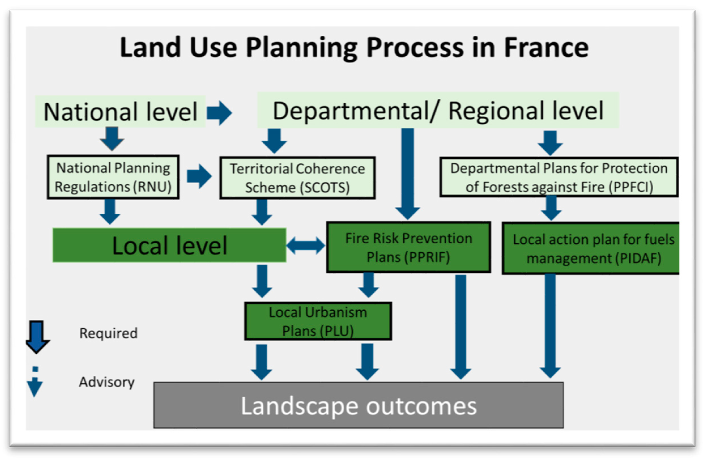
3.1. Land Use Planning in France

Land use planning in France is the jurisdiction of national, regional, and local governments. The national government creates a unified land use planning process framework for the entire country, which consists of 101 departments. Departments then mandate implementation of risk prevention plans, including wildfire risk reduction plans, by local jurisdictions. Local jurisdictions develop local land use plans which then must adopt these risk reduction plans as an overlay to their local plans.

3.1.1. The Role of National Government in France

The French national government dictates the context for local land use planning. Rules are contained in national planning regulations (Les Dispositions Impératives du Règlement National d’Urbanisme (RNU)). National policies are implemented in each department. Since the year 2000, each department has adopted a Schéma de cohérence territoriale (SCOT) (territorial coherence scheme) to delineate the major spatial development priorities in an area over the medium to long-term.
National policy is then implemented in each department by a prefect appointed by the country’s president. Therefore, the national government has a direct role in both setting priorities at regional levels and implementing them. Development of risk prevention plans (Plan de Prévention des Risques (PPR)) is mandated by national policy to control urbanization in areas at risk from natural hazards including flooding, earthquakes, landslides, and wildfire. Departmental prefects identify areas where risk is high and prescribe development of a PPR (see Figure 2).

3.1.2. The Role of Regional Governments

The primary planning document that limits building and re-building in fire prone areas is the community level PPRIF (Plan de Prévention des Risques d'Incendies des Forêts). Departmental officials impose the requirement to develop PPRIFs on local communities, requiring action on individual properties and even on individual structures. Departmental agencies, including fire, forestry, land, and development agencies, supply local jurisdictions with risk analysis and prepare the plans in consultation with local elected officials and citizens (Figure 3a). In the Rhone Delta department (Bouches-du-Rhône), the lead agency is the Department of Territories and the Sea (Direction Département des Territoires et de la Mer (DDTM 13)). Local communities work with agencies to finalize the PPRIF and integrate it into local plans. PPRIFs must be adopted by local jurisdictions as overlays to their PLUs and take precedence in the event of a conflict.
PPRIFs divide a jurisdiction into three planning zones (Figure 3b):
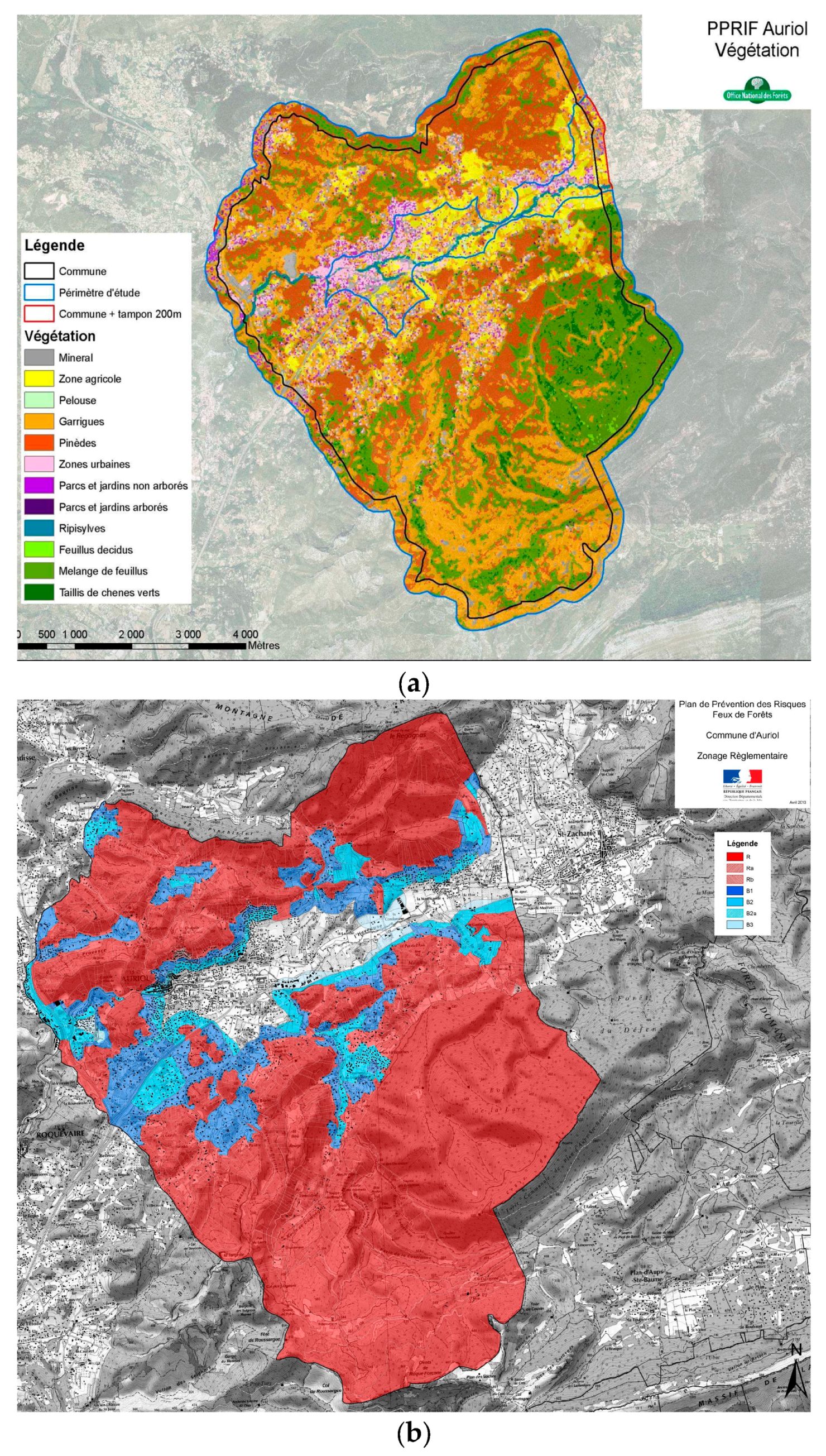
  • The Red Zone, where high fire hazard makes defense of property impossible. No development is permitted.
  • The Blue Zone (divided into B1, B2, and B3), where fire risk can be mitigated. Development is subject to conditions. In B1, development is allowed only if mitigation projects to reduce fire risk (including road improvement and water access) are completed. No large facilities that concentrate people such as hotels and gymnasiums are allowed and all construction must conform to fire prevention building codes. B2 zones are areas of moderate fire hazard with adequate fire defenses or where improvements can be made. New structures must be grouped and provided with wide access roads and water. B3 zones have low fire hazard with discontinuous fuels where intense fire is unlikely. These areas are subject to access and water requirements to reduce the risk of fire spreading to neighboring areas.
  • The White Zone, where forest fire hazard is very low and where compliance with the general requirements of the Forest Code ensures a satisfactory level of safety. Development is allowed subject to local planning regulations.
The PPRIF may prohibit existing homeowners from constructing additions or subdividing in red zones. Owners of existing homes may be required to make upgrades at their own expense by clearing defensible space, improving roads, and renovating homes by changing shutters, gutters, and building materials within five years of approval of the PPRIF, up to a cost equivalent to 10% of the property value. Exceptionally, the government can expropriate property if displacing people whose life is threatened by a risk proves to be the only solution at an acceptable cost. PPRIFs require local authorities to consider the construction of new access roads for fire and rescue vehicles and ongoing fuels clearance along roads for fire suppression. PPRIFs go through extensive vetting with local elected officials, agencies, and citizens. Local officials may request reclassification of areas designated as Red to B1 if they agree to install needed infrastructure at their own cost, such as community roads, fire hydrants, and clearing.
Each department (which is roughly equivalent to a county in the US) must develop a Departmental Plan for Protection of Forests against Fire (Plan de Protection des Forêts Contre l’Incendie (PPFCI)), which includes risk analysis and fire history, a situation diagnosis for each forested area in the department, priority strategies, and an action plan for brush clearing and forest management (Plans Intercommunaux de Débroussaillement et d’Aménagement Forestier (PIDAF)). Each department updates the plan annually with priorities for prevention, monitoring, rehabilitation of burned areas, and monitoring.

3.1.3. The Role of Local Governments

Local urbanism plans, (Plans Local d’Urbanisme—PLUs) are prepared by local jurisdictions under the direction of the elected mayor. The planning process is carried out on a collaborative basis involving the various levels of government in the department. The plan is subject to public review but, once approved, is valid for a period of ten years. The purpose of the PLU is to plan development by establishing use zones and rules for the local jurisdiction. The community is divided into four zones:
  • Urban, where new construction is permitted in existing developed and adjacent areas.
  • Available for urban development, where infrastructure is already available or planned.
  • Agricultural areas, where agricultural related construction is permitted.
  • Protected areas with sensitive historical, ecological, or environmental values, where no new construction is permitted.
The PLU lays out the maximum permitted density and constrains development of public spaces, utilities, natural parks, major infrastructure areas, historic sites, and monuments, as well as areas of major risk.
Local governments are led by mayors that are directly elected. They collaborate in the development of PPRs when these are assigned to them by the departmental prefect. PPRs are adopted as overlays to the PLU.

3.1.4. The Role of Citizens

Citizens impact planning by directly voting for their local elected officials who direct planning. Local plans (PLUs) are approved by an elected mayors after extensive comment by citizens. Local residents also comment and help craft PPRIFs. However, oversight of the planning process takes place by the department agencies, and the employees at this administrative level are representitives of the national government, not of the local jurisdiction. Town hall meetings are held in each jurisdiction developing a PPRIF. Planners incorporate public input into the final plans.

3.2. Land Use Planning in California

The United States has a federal government system in which each state has its own jurisdiction over land use planning. In California, planning is guided primarily by general plans, which are prepared at the local level. State laws enable local planning and also provide guidelines and minimium standards for general plans. In addition, state level fire information maintained by CAL FIRE (California Department of Forestry and Fire Protection) is utilized in local plans. Finally, the federal government manages wildfire risk on federal lands and provides funding for community based fire risk reduction projects.

3.2.1. The Role of National Government

The federal structure of the US government means that there is almost no direct role for the national level in local land use planning. However, the federal government can influence local plans in many ways. For one, the federal government can tie federal funds to local jurisdictions’ actions. For example, in order to be eligible for Federal Emergency Management Agency (FEMA) mitigation funds, local governments must adopt Local Hazard Mitigation Plans. Likewise, local governments must develop Community Wildfire Protection Plans in order to apply for federal fire fuels reduction funds.
The federal government is also involved in addressing fire issues through the management of public lands, including the national forest system by the USDA Forest Service, and by overseeing the National Fire Plan (with the Department of Interior), which was developed in August 2000. The goal is to respond to wildland fires and impacts to communities. The NFP addresses firefighting, rehabilitation, hazardous fuels reduction, community assistance, and accountability. In many rural areas of California, large amounts of land are managed by the federal government (about 1/3 of California is publicly owned), and the decisions of the land managers of these broad swaths of land may impact local wildfire risk [61]. In addition, the federal government’s enforcement of the Endangered Species Act can limit the location and size of developments.

3.2.2. The Role of Regional Government

California, as one of 50 states, is led by a popularly elected governor who implements policy developed by the state legislature. The State of California requires local governments to regulate land use and sets minimum standards that must be met, including the development of general plans, zoning, and subdivision ordinances. The state requires these local general plans and ordinances to address wildfire and makes recommendations through the state fire agency (CAL FIRE) but does not require specific actions of local communities.
The state also plays an important role as the main provider of technical fire risk information to local jurisdictions. CAL FIRE has created fire hazard zone maps for each county in California, and, since 2012, a new state law funds them to provide support to counties as they develop their general plans. Lands designated as Very High Fire Hazard Severity Zones (VHFHSZ) need to comply with California planning standards, including the development of more detailed fire risk assessments and the attainment of specific findings before subdivisions are allowed (Figure 4b).
The State Board of Forestry (BOF), which oversees CAL FIRE, is required to review and make recommendations for the safety element of general plan updates in VHFHSZ. If the local government decides not to accept recommendations, they must state in writing their reasons for not accepting them. Recommendations can include the development of fire safe development codes and fire protection plans, adoption of building codes (including automatic sprinklers) for new structures in VHFHSZ, development of evacuation routes, adoption of fuel reduction plans along roadways, and management plans for open space areas. There is no penalty for not implementing the state’s recommendations.
Likewise, CAL FIRE leads planning for wildfire at the state level. The Strategic Fire Plan for California (CAL FIRE 2010) identifies fire hazard mitigation goals, strategies, and indicators to measure success. Strategies include improving the availability and use of fire hazard and risk assessment information. In addition, CAL FIRE prepares a local area plan for each of 21 territorial units (which cover a cluster of counties) and six individual contract counties, which is updated annually. These local fire plans assess the local fire situation and identify strategic areas for pre-fire planning and fuel treatment in coordination with adjacent CAL FIRE units, national forests, and local collaborators
A fire prevention fee of up to $150 has also been imposed annually since 2013 on all structures in the State Responsibility Area (SRA), where CAL FIRE provides basic wildland fire prevention and protection services. SRA covers over 31 million acres of the state (about 12 million hectares). CAL FIRE also enforces state requirements for 100 feet of defensible space around structures and fire resistant materials in construction in fire hazard areas. CAL FIRE conducts defensible space inspections and, if these are failed over time, can take homeowners to court, levying fines until clearing is done.

3.2.3. The Role of the Local Government

Land use planning itself is conducted by local jurisdictions. General plans are required for each community in California and must have at least seven elements, including a land use, open space, and safety element. Wildfire can also be incorporated into the general plan through statements about preventing fire risk in the land use element and through suggestions for mitigating wildfire in the open space element. Current safety element requirements mandate that communities plan to mitigate wildfire risk by including ‘goals, policies and objectives and feasible implementation measures for the protection of the community from the reasonable risk of fire’ [53]. Local jurisdictions in VHFHSZ, as designated by the state, must take these risks into account in their plans. To aid in this process, the state Office of Planning and Research (OPR) directs communities to technical documentation in the ‘Fire Hazard Planning Technical Advisory’. Local communities can add additional elements, such as natural hazard elements, or even specific fire prevention elements. While the general plan guidelines require communities to think and plan for wildfire, they do not prescribe specific treatments; such decisions are left to local communities.
General plans provide broad outlines for community desires, while zoning provides specific prescriptions of land use. In California, county and city zoning plans generally cover most rural and WUI areas. County zoning designates densities of development allowed in different districts, including local variations on agricultural, resource (including forestry and timber production), and open space districts and residential, commercial, and industrial districts. These districts define allowable uses and the structure density that is permissible (Figure 4a).
Local governments can also adopt Community Wildfire Protection Plans (CWPPs) in collaboration with state and federal agencies (Figure 5). CWPPs identify and prioritize areas for hazardous fuel reduction treatments on both federal and non-federal land to reduce fire risk to the community. They must also recommend measures that homeowners and communities can take to reduce the ignitability of structures in the plan area.

3.2.4. The Role of the Citizen

Local planning is approved by elected city councils, mayors, and boards of supervisors after extensive comment by citizens. Citizen input to general plans and zoning is required by law in California, and, in practice, citizens can have a large impact on shaping general plans through direct participation in meetings. Likewise, local citizens impact planning by directly voting for their local elected officials. In many communities, there are also volunteer citizen advisory boards that make recommendations to elected officials regarding local planning issues. In these ways, citizens in California have a powerful voice in the planning process.

4. Discussion

Wildfire will continue to be part of life in Mediterranean climate ecosystems across the globe. Both France and the United States had large wildfire seasons in the early 2000s, and each adopted different strategies to improve planning to mitigate risk. In France, where the planning approach is centralized, national/regional government accelerated mandates for wildfire land use planning at the local level and set planning standards [62]. In the United States, where authority is decentralized and each state sets its own rules for planning land use primarily at the local level, the federal government instead focused on increasing financial incentives for local jurisdictions to improve planning for wildfire [18].
National involvement in local land use planning in France emphasizes risk reduction to homes, including fire risk. The imposition of standardized requirements and the development of nationwide standards establishes an even playing field across communities. In both countries, local elected officials may have incentives to allow building in high fire hazard areas to placate constituents or to build a tax base. However the imposition of a nationwide planning system in France can provide a counter balance to this local pressure and allow for more rational zoning and planning at the local level. This counter balance does not exist in the US and California, where local planners and officials are free to move forward plans that meet minimum state standards. There are many examples in California in which local officials have ignored fire hazard and allowed risky development. For example, after the Oakland hills fire of 1991, a state law was passed requiring mapping of high fire areas [52]. Although the City of Oakland strengthened their building and fire-prevention codes by placing new or additional regulations on the separation of buildings, ventilation criteria, roof materials, landscaping, and building access, they also permitted rebuilding of nearly all the destroyed homes, allowing many of them to increase in size. Such disregard for fire hazard by local authorities is more difficult in France.
Regional governments in both France and the US play important, although different, roles. In France, departments mandate the development of fire risk prevention plans (PPRIFs), which local authorities must accept and follow. They also provide technical expertise and coordinate local and national government actions. In California, the state government identifies high fire risk areas and sets guidelines in the form of general plan requirements, and, though it can now make specific wildfire mitigation recommendations, local governments are not required by law to adopt them. Thus, while the state of California plays an important role in land use planning, it cannot require local governments to prohibit development in high fire hazard areas as the French departments can.
At the local level, both France and California rely on local elected officials to plan for wildfire risk reduction and incorporate citizen input into plans. In California, state and federal agencies have limited recourse beyond lawsuits if they disagree with general plans and zoning ordinances, which may lead to fire risk. This gives local communities greater leeway than in France, where local planning decisions can be overruled by national and regional authorities. There is no requirement for federal land management or other agencies in the US to participate in local land use planning, though it does occasionally occur [63].
Overall, France has responded to the increasing hazard of wildfire in the WUI by accelerating the adoption of PPRIFs mandated by their centralized government structure. PPRIFs require local governments in the highest risk areas to prevent and regulate building into fire prone areas. In practice, the development of PPRIFs has been slow due, in part, to the sheer quantity of fire hazard areas. For example, 110 of the 119 communes2 in the Rhone Delta department (Bouches-du-Rhone) have been designated as at some risk from wildfires, but so far less than a dozen PPRIFs have been adopted [64]. The adoption of PPRIFs has also been slowed by resistance from local governments. The process has increased tensions between national and local governments in many areas because PPRIFs shift some of the costs of fire hazard mitigation to local communities and landowners [62].
The centralized French system, which can prohibit development in fire prone areas, appears to have some advantages over the decentralized system in California, which generally does not. However, the prospects for increasing the role of the federal government in local land use planning in the US seem slim. It also seems likely that local jurisdictions in California would resist any ceding of local authority over planning and zoning to the state government, even if they thought it would lead to better results. The reliance on local governments for land use planning for wildfire echoes findings from other studies that have looked at governance and wildfire management more generally; In the United States, the federal government relies on local communities to address wildfires and relies on funding mechanisms as the primary way to influence local actions [18,19].
On the other hand, decentralized authority in the US can allow individual California jurisdictions to take innovative approaches to reduce building in fire risk areas. Local jurisdictions do not need to wait for policy changes at the state level to pursue more stringent building requirements in fire risk areas. Changes in leadership in countries with more centralized governance, such as France, can lead to policy shifts that affect the entire polity.
There are actions that could be taken in California to improve land use planning for wildfire throughout. First, local governments could try to develop their own restrictions on building in fire prone areas within their jurisdictions. State and federal governments could also take a larger role in providing fire related information for local communities. Especially in the Sierra, where the majority of land is managed by the federal government, the federal government could work to supply local authorities with up-to-date maps of fuels, fire hazards, and fire-fighting plans for federal lands to help local governments better assess wildfire risks. At the same time, coordination between agencies may lead to higher quality fire hazard maps, which are essential to planning.
Second, beyond information sharing, federal, state, and local authorities could work to coordinate actions regarding land use planning and fire risk. Currently, state level agencies have an advisory role in local planning. This role could be made more formal by requiring development of comprehensive wildfire risk mitigation recommendations for consideration in local land use planning processes.
Third, the state of California could mandate stronger risk reduction by local governments by strengthening the land use planning requirements in general plans. Currently, general plans must address threats from wildfire, but do not prohibit homes being built in fire prone areas. Also, while fire hazard zones can influence the location of subdivisions, they do not impact the spatial arrangement of homes, which can be important in many cases [10]. The state could strengthen the language to require local jurisdictions to limit construction in hazardous areas and mandate design criteria. Likewise, the state could offer incentives such as money for fuel reduction programs to communities who incorporate strong fire risk reduction programs into their general plans and zoning ordinances.
In France, better collaboration between local and national/departmental government during the local land use planning process (development of PLUs) could allow for local plans to better incorporate fire risk information in the first place. This would reduce the number of PPRIFs needed to overlay local planning decisions that do not take wildfire risk into account.
Although the exact reasons are not clear, far fewer structures are burned by wildfire in France than in California (Table 1). Aside from land use planning, other factors undoubtedly contribute to the relatively small loss of structures in the WUI in France. Structures face less fire exposure because of the many fewer acres burned in France. Construction materials are no doubt also important, since French homes are generally built of non-combustible stone, concrete, and tile. Population density may also reduce structure loss by reducing the relative size and scale of wildlands. It may also increase the resources available for fire suppression, compared to a much more sparsely populated Sierra Nevada (Table 1). Climate variability, vegetation and fuel characteristics, and wildfire suppression tactics also vary between the two locations. These factors deserve further investigation.

5. Conclusions

As the risk of wildfire structure loss continues to increase in both California and France, due to population growth and building in wildfire areas, improved methods are needed to ensure that land use planning properly incorporates wildfire risk. National governments in the US and France have responded differently, in decentralized and centralized ways, respectively. In centralized France, the response to risk was to strengthen requirements that local jurisdictions adopt policies, imposed by national and regional governments, which prohibit construction in high fire hazard areas. In the US, with its decentralized governance system, the federal government has responded to increasing risk by increasing financial incentives to community-based wildfire risk planning. California, has required its local jurisdictions to consider risk in land use planning but has not mandated specific measures, meaning that development in high fire hazard areas is rarely prohibited.
Recent loss of structures in the WUI in Mediterranean France has been limited, while California continues to experience much more fire and substantial home loss in most years. Many factors may produce this difference in home loss, including land use planning, vegetation and fuel characteristics, fire behavior and exposure, population and urban density, construction materials, suppression tactics, resources allocated, and climate variability. Cross cultural comparisons of these factors in France, California, and other areas with Mediterranean climates would contribute to improvements in land use planning for wildfire risk.

Acknowledgments

We thank all the fire and planning experts who took pains to describe and interpret the land use and fire planning process in France including Vincent Pastor, S.D.I.S. 13; Jean-Jacques Bozabalian and Christophe Frerson, L’Etat-Major Interministériel del la Zone de Défense et de Sécurité Sud; and Yvon Duché, Office National des Forêts. Thanks also to Frédéric-Georges Roux of Fransylva 83, Le Syndicat des Propriétaires Forestiers Sylviculteurs du Var. We would also like to thank Dave Sapsis of CAL FIRE for reviews of the manuscript. No funds were received to conduct this research. An author was supported for research in France through sabbatic leave by the University of California.

Author Contributions

Susan D. Kocher conceived of and designed the research during a six month sabbatic internship at L’Etat-Major Interministériel del la Zone de Défense et de Sécurité Sud in Aix en Provence, France. She reviewed French planning documents and conducted interviews and a field trip to a community with a PPRIF. Van Butsic reviewed documents in California and consulted Californian fire and land use experts. Both authors wrote the paper.

Conflicts of Interest

The authors declare no conflict of interest.

References

  1. Brotons, L.; Aquilué, N.; de Cáceres, M.; Fortin, M.-J.; Fall, A. How fire history, fire suppression practices and climate change affect wildfire regimes in Mediterranean landscapes. PLoS ONE 2013, 8, e62392. [Google Scholar] [CrossRef] [PubMed]
  2. Silva, J.S.; Vaz, P.; Moreira, F.; Catry, F.; Rego, F.C. Wildfires as a major driver of landscape dynamics in three fire-prone areas of Portugal. Landsc. Urban Plan. 2011, 101, 349–358. [Google Scholar] [CrossRef]
  3. Pausas, J.G. Changes in Fire and Climate in the Eastern Iberian Peninsula (Mediterranean Basin). Clim. Chang. 2004, 63, 337–350. [Google Scholar] [CrossRef]
  4. Syphard, A.D.; Radeloff, V.C.; Keeley, J.E.; Hawbaker, T.J.; Clayton, M.K.; Stewart, S.I.; Hammer, R.B. Human influence on California fire regimes. Ecol. Appl. 2007, 17, 1388–1402. [Google Scholar] [CrossRef] [PubMed]
  5. Syphard, A.D.; Radeloff, V.C.; Keuler, N.S.; Taylor, R.S.; Hawbaker, T.J.; Stewart, S.I.; Clayton, M.K. Predicting spatial patterns of fire on a southern California landscape. Int. J. Wildl. Fire 2008, 17, 602–613. [Google Scholar] [CrossRef]
  6. Puerta-Piñero, C.; Espelta, J.M.; Sánchez-Humanes, B.; Rodrigo, A.; Coll, L.; Brotons, L. History matters: Previous land use changes determine post-fire vegetation recovery in forested Mediterranean landscapes. For. Ecol. Manag. 2012, 279, 121–127. [Google Scholar] [CrossRef]
  7. Fernandes, P.M. Fire-smart management of forest landscapes in the Mediterranean basin under global change. Landsc. Urban Plan. 2013, 110, 175–182. [Google Scholar] [CrossRef]
  8. Sturtevant, B.; Miranda, B.; Yang, J.; He, H.; Gustafson, E.; Scheller, R. Studying Fire Mitigation Strategies in Multi-Ownership Landscapes: Balancing the Management of Fire-Dependent Ecosystems and Fire Risk. Ecosystems 2009, 12, 445–461. [Google Scholar] [CrossRef]
  9. Syphard, A.D.; Bar Massada, A.; Butsic, V.; Keeley, J.E. Land use planning and wildfire: Development policies influence future probability of housing loss. PLoS ONE 2013, 8, e71708. [Google Scholar] [CrossRef] [PubMed]
  10. Syphard, A.D.; Keeley, J.E.; Massada, A.B.; Brennan, T.J.; Radeloff, V.C. Housing Arrangement and Location Determine the Likelihood of Housing Loss Due to Wildfire. PLoS ONE 2012, 7, e33954. [Google Scholar] [CrossRef] [PubMed]
  11. Cohen, J.; Johnson, N.; Walther, L. Saving homes from wildfires: Regulating the home ignition zone. Zoing News, May 2001; 1–5. [Google Scholar]
  12. Babcock, R.F. The Zoning Game: Municipal Practices and Policies; University of Wisconsin Press: Madison, WI, USA, 1969. [Google Scholar]
  13. Butsic, V.; Syphard, A.D.; Keeley, J.E.; Bar-Massada, A. Can private land conservation reduce wildfire risk to homes? A case study in San Diego County, California, USA. Landsc. Urban Plan. 2017, 157, 161–169. [Google Scholar] [CrossRef]
  14. McCaffrey, S. Thinking of Wildfire as a Natural Hazard. Soc. Nat. Resour. 2004, 17, 509–516. [Google Scholar] [CrossRef]
  15. Rice, C.L.; Davis, J.B. Land-Use Planning May Reduce Fire Damage in the Urban-Wildland Intermix; Gen. Tech. Rep. PSW-127; Pacific Southwest Research Station, Forest Service, U.S. Department of Agriculture: Berkeley, CA, USA, 1991; p. 13.
  16. Fischer, A.P.; Spies, T.A.; Steelman, T.A.; Moseley, C.; Johnson, B.R.; Bailey, J.D.; Ager, A.A.; Bourgeron, P.; Charnley, S.; Collins, B.M.; et al. Wildfire risk as a socioecological pathology. Front. Ecol. Environ. 2016, 14, 276–284. [Google Scholar] [CrossRef]
  17. Moritz, M.A.; Batllori, E.; Bradstock, R.A.; Gill, A.M.; Handmer, J.; Hessburg, P.F.; Leonard, J.; McCaffrey, S.; Odion, D.C.; Schoennagel, T.; et al. Learning to coexist with wildfire. Nature 2014, 515, 58–66. [Google Scholar] [CrossRef] [PubMed]
  18. Steelman, T.A.; Kunkel, G.F. Effective Community Responses to Wildfire Threats: Lessons From New Mexico. Soc. Nat. Resour. 2004, 17, 679–699. [Google Scholar] [CrossRef]
  19. Steelman, T.A.; Kunkel, G.; Bell, D. Federal and State Influence on Community Responses to Wildfire Threats: Arizona, Colorado, and New Mexico. J. For. 2004, 102, 21–28. [Google Scholar]
  20. Hughes, R.; Mercer, D. Planning to Reduce Risk: The Wildfire Management Overlay in Victoria, Australia. Geogr. Res. 2009, 47, 124–141. [Google Scholar] [CrossRef]
  21. Buxton, M.; Haynes, R.; Mercer, D.; Butt, A. Vulnerability to Bushfire Risk at Melbourne’s Urban Fringe: The Failure of Regulatory Land Use Planning. Geogr. Res. 2011, 49, 1–12. [Google Scholar] [CrossRef]
  22. Bhandary, U.; Muller, B. Land use planning and wildfire risk mitigation: An analysis of wildfire-burned subdivisions using high-resolution remote sensing imagery and GIS data. J. Environ. Plan. Manag. 2009, 52, 939–955. [Google Scholar] [CrossRef]
  23. Mann, M.L.; Berck, P.; Moritz, M.A.; Batllori, E.; Baldwin, J.G.; Gately, C.K.; Cameron, D.R. Modeling residential development in California from 2000 to 2050: Integrating wildfire risk, wildland and agricultural encroachment. Land Use Policy 2014, 41, 438–452. [Google Scholar] [CrossRef]
  24. Harris, L.M.; McGee, T.K.; McFarlane, B.L. Implementation of wildfire risk management by local governments in Alberta, Canada. J. Environ. Plan. Manag. 2011, 54, 457–475. [Google Scholar] [CrossRef]
  25. Muller, B.; Schulte, S. Governing Wildfire Risks: What Shapes County Hazard Mitigation Programs? J. Plan. Educ. Res. 2011, 31, 60–73. [Google Scholar] [CrossRef]
  26. Stephens, S.L.; Adams, M.A.; Handmer, J.; Kearns, F.R.; Leicester, B.; Leonard, J.; Moritz, M.A. Urban–wildland fires: How California and other regions of the US can learn from Australia. Environ. Res. Lett. 2009, 4, 14010. [Google Scholar] [CrossRef]
  27. Gill, A.M.; Stephens, S.L.; Cary, G.J. The worldwide “wildfire” problem. Ecol. Appl. 2013, 23, 438–454. [Google Scholar] [CrossRef] [PubMed]
  28. Keeley, J.E. Native American impacts on fire regimes of the California coastal ranges. J. Biogeogr. 2002, 29, 303–320. [Google Scholar] [CrossRef]
  29. Franklin, J.; Coulter, C.L.; Rey, S.J. Change over 70 years in a southern California chaparral community related to fire history. J. Veg. Sci. 2004, 15, 701–710. [Google Scholar] [CrossRef]
  30. Attiwill, P.; Binkley, D.; Ganteaume, A.; Jappiot, M. What causes large fires in Southern France. For. Ecol. Manag. 2013, 294, 76–85. [Google Scholar]
  31. Fernandes, P.M.; Lampin-Maillet, C.; Long-Fournel, M.; Ganteaume, A.; Jappiot, M.; Ferrier, J.P. Land cover analysis in wildland–urban interfaces according to wildfire risk: A case study in the South of France. For. Ecol. Manag. 2011, 261, 2200–2213. [Google Scholar]
  32. Stegen, J.C.; Freestone, A.L.; Crist, T.O.; Anderson, M.J.; Chase, J.M.; Comita, L.S.; Cornell, H.V.; Davies, K.F.; Harrison, S.P.; Hurlbert, A.H.; et al. Stochastic and deterministic drivers of spatial and temporal turnover in breeding bird communities. Glob. Ecol. Biogeogr. 2013, 22, 202–212. [Google Scholar] [CrossRef]
  33. Booth, P. Decentralization and land use planning in France: A 15 year review. Policy Politics 1998, 26, 89–105. [Google Scholar] [CrossRef]
  34. Jacobs, H.M. Who Owns America; University of Wisconsin Press: Madison, WI, USA, 1998. [Google Scholar]
  35. Keeley, J.E.; Bond, W.J.; Bradstock, R.A.; Pausas, J.G.; Rundel, P.W. Fire in Mediterranean Ecosystems: Ecology, Evolution and Managment; Cambridge University Press: Cambridge, UK, 2011. [Google Scholar]
  36. Woodward, J.C. The Physical Geography of the Mediterranean; Oxford University Press: Oxford, UK, 2009. [Google Scholar]
  37. Pyne, S.J. Vestal Fire: An Environmental History, Told through Fire, of Europe and Europe’s Encounter with the World; University of Washington Press: Seattle, WA, USA, 1997. [Google Scholar]
  38. Whited, T.L. Extinguishing disaster in Alpine France: The fate of reforestation as technocratic debacle. GeoJournal 2000, 51, 263–270. [Google Scholar] [CrossRef]
  39. Vallauri, D.R.; Aronson, J.; Barbero, M. An Analysis of Forest Restoration 120 Years after Reforestation on Badlands in the Southwestern Alps. Restor. Ecol. 2002, 10, 16–26. [Google Scholar] [CrossRef]
  40. Velez, R. The causing factors: A focus on economic and social driving forces. In Living with Wildfires, What Science Can Tell Us: A Contribution to the Science; Briot, Y., Ed.; European Forest Institute, Mediterranean Regional Office: Barcelona, Spain, 2009; p. 78. [Google Scholar]
  41. Bassi, S.; Kettunen, M.; Kampa, E.; Cavalieri, S. Forest Fires: Causes and Contributing Factors to Forest Fire Events in Europe; Study for the European Parliament Committee on Environment. Public Health and Food Safety under contract IP/A/ENVI/ST/2007-15 PE 401.003; Institute for European Environmental Policy: Brussels, Belgium, 2008. [Google Scholar]
  42. Van Stralen, D.; Provansal, G. The French Connection: French wildland fire fighters find success through high reliability concepts. Wildl. Firef. 2007, 26–34. [Google Scholar]
  43. Stephens, S.L.; Martin, R.E.; Clinton, N.E. Prehistoric fire area and emissions from California’s forests, woodlands, shrublands, and grasslands. For. Ecol. Manag. 2007, 251, 205–216. [Google Scholar] [CrossRef]
  44. Kocher, S.; Beckwitt, S. Forest Health and Carbon Storage; System Indicators. A report to the Sierra Nevada Conservancy, Auburn, California 2012. Available online: http://www.sierranevada.ca.gov/our-region/sys_ind_docs/SystetmIndicatorsForestHealth.pdf (accessed on 30 March 2017).
  45. Pincetl, S. Transforming California, The Political History of Land Use and Developemnt, 1st ed.; Johns Hopkins University Press: Baltimore, MD, USA, 2003. [Google Scholar]
  46. Wagtendonk, J.W.V. The History and Evolution of Wildland Fire Use. Fire Ecol. 2007, 3, 3–17. [Google Scholar] [CrossRef]
  47. Hammer, R.B.; Radeloff, V.C.; Fried, J.S.; Stewart, S.I. Wildland–urban interface housing growth during the 1990s in California, Oregon, and Washington. Int. J. Wildl. Fire 2007, 16, 255–265. [Google Scholar] [CrossRef]
  48. Radeloff, V.; Hammer, R.; Stewart, S.; Fried, J.; Holcomb, S.; McKeefry, J. The wildland-urban interface in the United States. Ecol. Appl. 2005, 15, 799–805. [Google Scholar] [CrossRef]
  49. Dolanc, C.R.; Safford, H.D.; Thorne, J.H.; Dobrowski, S.Z. Changing forest structure across the landscape of the Sierra Nevada, CA, USA, since the 1930s. Ecosphere 2014, 5, 1–26. [Google Scholar] [CrossRef]
  50. Steel, Z.L.; Safford, H.D.; Viers, J.H. The fire frequency-severity relationship and the legacy of fire suppression in California forests. Ecosphere 2015, 6, 1–23. [Google Scholar] [CrossRef]
  51. State of California General Plan Guidelines. Available online: https://www.opr.ca.gov/s_generalplanguidelines.php (accessed on 12 May 2016).
  52. State of California FRAP—Wildfire Hazard Real Estate Disclosure. Available online: http://frap.fire.ca.gov/projects/hazard/hazard (accessed on 12 May 2016).
  53. Alex, K.; Morgan, S.; Rubin, B.; Calfee, C.; Glover, N. Fire Hazard Planning General Plan Technical Advice Series; Governor’s Office of Planning and Research: Sacramento, CA, USA, 2014.
  54. State of California Fire Prevention Fee. Available online: http://www.firepreventionfee.org/ (accessed on 12 May 2016).
  55. State Board of Forestry and Fire Protection, California Department of Forestry and Fire Protection. 2010 Strategic Fire Plan for California. Available online: http://cdfdata.fire.ca.gov/pub/fireplan/fpupload/fpppdf668.pdf (accessed on 30 March 2017).
  56. Forest and Rangelands National Cohesive Wildland Fire Management Strategy. Available online: https://www.forestsandrangelands.gov/strategy/ (accessed on 16 October 2016).
  57. National Oceanic and Atmospheric Administration Endangered Species Act. Available online: http://www.nmfs.noaa.gov/pr/laws/esa/ (accessed on 1 January 2015).
  58. Forest and Rangeland Community Wildfire Protection Plan (CWPP). Available online: https://www.forestsandrangelands.gov/communities/cwpp.shtml (accessed on 12 October 2016).
  59. Federal Emergency Management Agency Local Mitigation Planning Handbook | FEMA.gov. Available online: https://www.fema.gov/media-library/assets/documents/31598 (accessed on 30 March 2017).
  60. U.S. Forest Service The National Fire Plan. Available online: https://www.forestsandrangelands.gov/resources/overview/ (accessed on 16 October 2016).
  61. Butsic, V.; Kelly, M.; Moritz, M. Land Use and Wildfire: A Review of Local Interactions and Teleconnections. Land 2015, 4, 140–156. [Google Scholar] [CrossRef]
  62. Bouisset, C. PPR, Urbanization and Forest Fire Risks in Pyrénées-Orientales Department: Methods, Issues, Debates. Available online: http://cybergeo.revues.org/24658 (accessed on 30 March 2017).
  63. Carr, M.; Stein, S. Across the Green Line: How Forest Service Employees Can Support Local Land Use Planning Efforts; FS-1021; Department of Agriculture (USDA), Forest Service: Washington, DC, USA, 2014; p. 36.
  64. Rhone Delta Department Porter à Connaissance du Risque Incendie de Forêt/La Prévention/Sécurité Civile/Sécurité/Politiques Publiques/Accueil—Les Services de l’État dans le Département des Bouches-du-Rhône. Available online: http://www.bouches-du-rhone.gouv.fr/Politiques-publiques/Securite/Securite-civile/La-prevention/Porter-a-Connaissance-du-risque-incendie-de-foret (accessed on 13 February 2017).
1
France is divided into regions, which are then divided into a total of 96 departments. They are similar to counties within American states.
2
Departments are divided into communes, which are similar to US townships. There are about 36,000 in France.
Figure 1. (a) Typical fire-adapted forest in Mediterranean France with Aleppo pine (Pinus halepensis), green oak (Quercus ilex), and pubescent oak (Quercus pubescens), March 2016. (b) Typical fire-adapted forest in the Sierra Nevada in Amador County with ponderosa pines (Pinus ponderosa) and black oaks (Quercus kelloggii), June 2015.
Land 06 00024 g001
Figure 2. Schematic of land use planning to reduce wildfire hazard in France. The national government develops planning rules (RNUs), and the regional/departmental government mandates local fire hazard reduction plans (PPRIFs) to overlay land use plans (PLUs) developed by local government (PLU).
Land 06 00024 g002
Figure 3. (a) Map from the Plan de Prévention des Risques d’Incendies des Forêts (PPRIF) for Auriol, France. The predominant vegetation types are shown, as well as the agricultural (zone agricole) and urban (zones urbaines) land use zones. (b) Overlay of wildfire hazard zoning developed in the Auriol PPRIF with Red, B1, B2, and B3 zones. No new construction is allowed in the Red Zone due to wildfire hazard.
Land 06 00024 g003
Figure 4. (a) Land use zones established by the Amador County General Plan Zoning Ordinance; (b) Overlay of wildfire hazard zones developed by CAL FIRE for use by Amador County along with areas that allow residential construction.
Land 06 00024 g004
Figure 5. Schematic of land use planning for wildfire in California. The federal government has limited influence on landscape outcomes, primarily through the allocation of fire funding and through programs that were not intended as tools to mitigate fire risk, such as the Endangered Species Act, and management of adjacent lands. The state government establishes local planning rules and has an important advisory role for local government. Local planning laws, general plans and zoning ordinances, have direct impacts on landscape outcomes.
Land 06 00024 g005
Table 1. People and Fire in California, the Sierra Nevada, France, and the 15 departments of Mediterranean France.
Country/StatePopulation (Millions 2013)Area (km2)Density (Persons/km2 2013)% Forest% of Total Forest Land OwnershipArea Burned Annually (km2 2010–2015)Largest Fires (km2)Largest Structure Loss Due to Fire (# Structures)
PublicPrivate
France66643,80112131%26%74%84
Mediterranean France8.8155,5405738%28%72%40614 for all 2003 fires<10 per year from all fires *
California39423,9719733%60%40%21261106 in 2003 Cedar Fire3280 in 1991 Oakland hills fire
Sierra Nevada0.898,819843%71%29%9311012 in 2013 Rim Fire921 in 2015 Butte fire
* According to Yvon Duché, Personal Communication 9 May 2016, no database is kept.

