1. Introduction
Globally, the human habitat has changed fundamentally and profoundly since the end of the 20th century. As is widely known, the planet became majority urban in the first decade of the 21st century. This transformation did not occur overnight. Beginning with England, the population of other western European nations and the United States became mostly urban in the mid to late 19th and early 20th centuries. China became dominated by an urban population more recently in 2011. Urbanization in China is dramatic, with 70 percent of its population expected to live in cities in the next 20–30 years. Globally, the growth in the number of people living in city-regions continues to climb.
Landscapes are combinations of natural and cultural phenomena. We understand that cities are a product of cultural adaptation. We are less likely to see nature in the city beyond the parks we have designed and left-over unbuildable sites. Landscape perspectives at several scales from the site to the region can help us appreciate urban nature and, therefore, design and plan more appropriate and safer urban communities. As landscapes differ from place to place so too should the perspective be adjusted. However, the fundamental elements that comprise landscape are similar in different places; that is, there are climatic, geologic, hydrologic, biologic, and cultural processes that should be understood. Landscapes are helpful syntheses of these processes.
The need for such a perspective should be self-evident. Growing cities require more resources. The water-energy nexus provides an example of the consequences. Greater water use, especially hot water use, requires more energy. In turn, increased energy use demands more water. (For data about urbanization trends in the United States and related energy and water consumption, see the Organization for Economic Cooperation and Development Factbook [
1] and the CIA World Economic Factbook [
2].) Meanwhile, urbanization consumes prime farmland and valuable wildlife habitat. As urban areas expand, settlement moves into risky places, those prone to flooding, wildfire, avalanche, earthquake, and sea surge. And, as the climate of the planet warms, so do extreme weather events. As a result, more urban areas are susceptible to natural disaster. A landscape perspective, one that helps illuminate the constraints and the opportunities of various human uses, can save lives and property.
This paper contains five parts. First, the ecology of urban places is summarized. Then examples of landscape perspectives for planning and design are provided in Dayton, Ohio; Brooklyn, New York; and Austin, Texas. The paper concludes with speculations about the prospects for urban landscape perspectives.
2. Ecology Comes to the City
Traditionally, ecologists avoided the study of urban places, preferring locations far beyond the city limits. These locations influenced the evolution of the field. For example, the development of ideas like the organismic view, climax, competition, mutualism, predation, ecotones, the continuum view, and gradients was informed by the locations where plant communities were studied by the researchers.
Although ecology focused on plant and animal communities, there has been a long-standing interest in human implications from the ill-conceived notions of environmental determinism during the 1920s on to more thoughtful explorations by Aldo Leopold [
3], Paul Sears [
4], and Eugene and Howard T. Odum [
5,
6]. These ideas gained breadth and depth through the rise of landscape ecology, urban ecology, and ecosystem services.
Richard Forman [
7,
8,
9] has been instrumental in the development of, first, landscape ecology and, more recently, urban ecology. Ecology is an evolving discipline with an increasing focus on landscapes and urban regions. Forman and Godron [
7] are responsible for defining the field of landscape ecology. They explain: “
Landscapes as ecological units with structure and function are composed primarily of patches in a matrix. Patches differ fundamentally in origin and dynamics, while size, shape, and spatial configuration are also important. Line corridors, strip corridors, stream corridors, networks, and habitations are major integrative structural characteristics of landscapes” ([
7], p. 733). Forman expanded the field to encompass the landscape ecology of regions. His particular interest was to address the ecology of landscapes and regional “beyond the city” [
8]. Meanwhile, ecologists, including Forman [
9], have also begun to refocus their science inside the city.
The U.S. National Science Foundation (NSF) supports a network of 26 Long Term Ecological Research (LTER) projects. The NSF initiated the LTER program in 1980 to advance research on long-term ecological phenomena. The LTER mission is to document, analyze, and understand ecological processes and patterns that change over long temporal and large spatial scales. Until 1997, these LTERs were located outside urban regions. After an intense competition, the NSF selected the contrasting American cities of Phoenix [
10] and Baltimore [
11] for its first urban LTERs. Baltimore has a longer European settlement history and is located in a relatively humid, coastal region. Although there were ancient native settlements, the Phoenix region has grown rapidly since World War II and is located in a desert.
The Baltimore LTER aims to understand the metropolitan region as an ecological system. The Baltimore Ecosystem Study team of cross-disciplinary researchers explores complex interactions between the built and the natural environments with ecological, social, economic, and hydrological processes [
12]. The Baltimore LTER attempts to advance both ecological research and environmental policy. For example, “our finding that urban riparian zones experiencing hydrologically induced drought are not sinks for nitrate, but in fact may be nitrate sources, helped lead policy makers concerned with the water quality of the Chesapeake Bay to reduce their reliance on stream corridor tree planting as a primary mitigation strategy” ([
12], p. 51).
The Central Arizona-Phoenix LTER also includes an interdisciplinary team of researchers at Arizona State University (ASU). They study the interactions of ecological and socio-economic systems in a rapidly growing urban environment. ASU researchers have especially advanced our understanding of land-use change on ecological patterns and processes [
13,
14]. Such understanding is important as cities in the Southwest United States continue to grow rapidly in an environmentally sensitive context.
In addition to the formal NSF-backed urban LTERs, other U.S. scholars are advancing and/or influencing urban ecology research across disciplines, most notably in the Puget Sound region of the Pacific Northwest [
15] and the Hubbard Brook Ecosystem Study in central New Hampshire [
16]. The Puget Sound group from the University of Washington has contributed to understanding of ecological resilience in urban ecosystems. Resilience, from the Latin
resilire meaning to spring back or rebound, is a concept and a theory with growing appeal in ecology. When rising from traditional concepts in ecology, resilience emphasizes equilibrium and stability. However, a simple return to the status quo is usually not possible and often not desirable. As a result, resilience has become understood as the capacity of an ecosystem to tolerate disturbance and adapt to changing conditions while retaining its basic functions and structures and, in many cases (but not all), returning to a recognizable state following perturbation or disturbance. Some disturbances, while unpredictable in terms of precise timing, will be normal occurrences to which the ecosystem in question is at some scale, already adapted, or to which the ecosystem has internal adaptive capacity. Other change events may be sudden, large-scale, or catastrophic occurrences to which the ecosystem responds by moving to another semi-stable state but to which it adapts in terms of functions and structures. Resilience also includes the human learning capacity that is necessary for adaptation [
17,
18]. The United Nations defines resilience as the ability to absorb disturbances while retaining the same basic structure and ways of functioning, the capacity for self-organization, and the capacity to adapt to stress and change.
The Hubbard Brook Ecosystem Study is an LTER but not an urban landscape. However, it is important to the lineage of urban LTERs because of its significance in establishing the concept of ecosystem services related to water and nutrient cycling, and for the fact it spawned hundreds of scientific studies that cumulatively laid the ground work for the urban LTERs in terms of both research methods and strategy. The Hubbard Brook Ecosystem Study addresses neither an urban or wilderness site, but its location today, after decades of monitoring, reflects the growth of peri-urban ecosystems in continental North America.
As a result of urban-based ecological studies, urban ecology is emerging as a field that emphasizes an interdisciplinary approach to understanding the drivers, patterns, processes, and outcomes associated with urban and urbanizing landscapes [
19,
20]. Marina Alberti [
21] conceives of urban ecosystems as complex coupled human-natural systems where people are the dominant modifiers of ecosystems, thus producing hybrid social-ecological landscape patterns and processes. Some urban ecology research focuses on the impact of habitat fragmentation of suburban and urban housing development patterns for avian species productivity; other research focuses on the integration of scientific analyses into growth-management strategies. Such diverse research agendas are united in their recognition that urban ecosystems—which affect the quality of life for the majority of the planet’s residents—are characterized by complexity, heterogeneity, and hybridity and are, therefore, best analyzed within an interdisciplinary approach. As a result, urban ecology has significant consequences for environmental design and city and regional planning.
Another relatively new concept, ecosystem services, also has relevance to design and planning. Ecosystem services help define the human benefits provided by nature, such as the production of clean water, energy carbon sequestration, seed dispersal, and recreation. The concept of ecosystem services provides a way to express the values that natural environments and processes create for people. Generally, such services are not recognized or are undervalued in traditional economic assessments. Three examples help illustrate how urban ecology and ecosystem services can be advanced through landscape perspectives.
3. Learning to Live With Floods
Planning based on environmental knowledge is not a new activity. Drainage-basin scale planning in the Great Miami Valley of Ohio provides an example. The Great Miami Valley had been the Silicon Valley of the early 20th century: a center of innovation and new business development. At the confluence of several small rivers, its principal city, Dayton, had proven to be an ideal hub for the canal linking the Ohio River to Lake Erie. Earlier, Indians found the moraine terrain favorable for settlement as well. Farmers thrived on the deep glacial soils to the north, with small river falls ideal for milling grain and generating power.
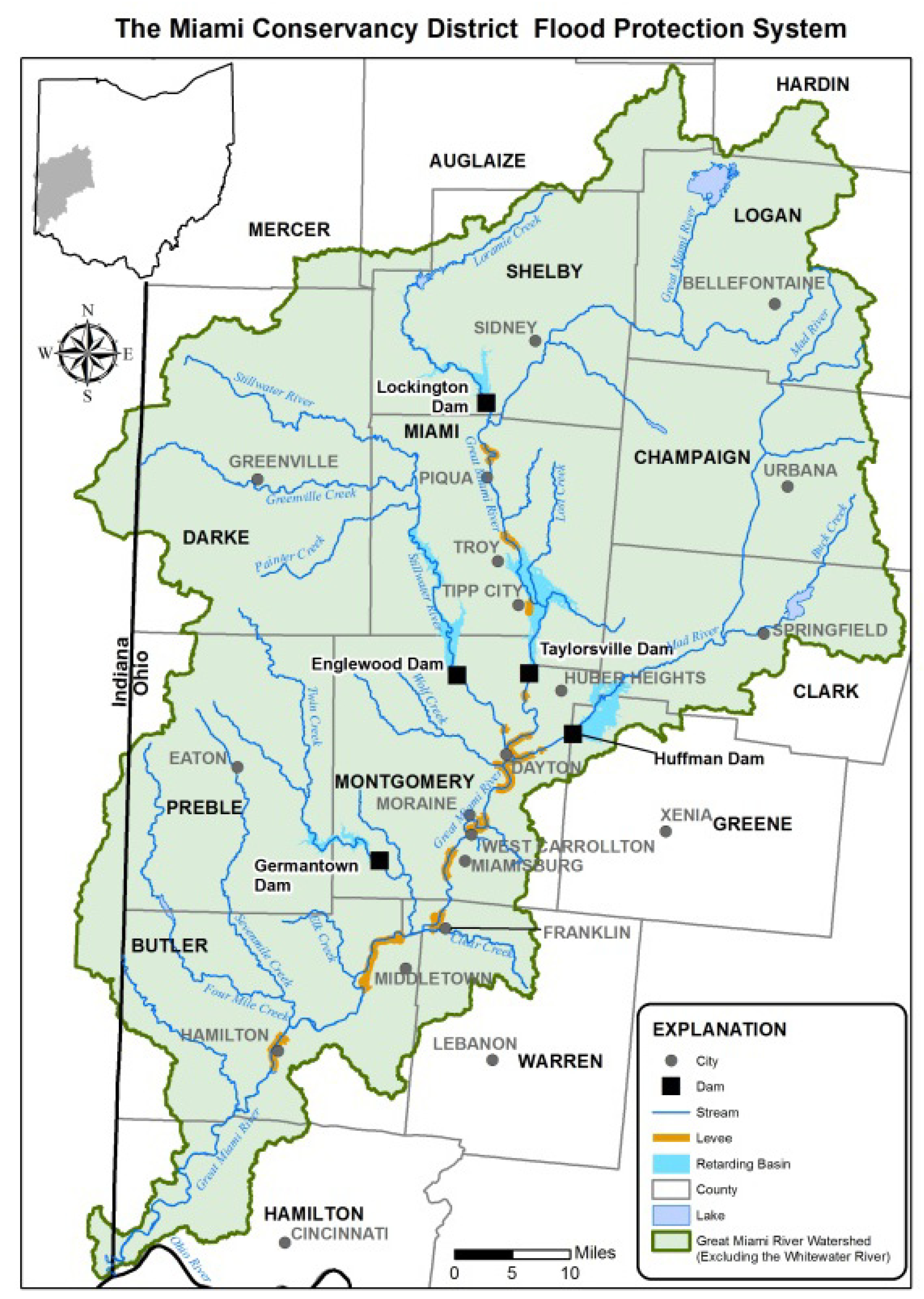
In 1913, record rainfall resulted in a major flood. When coupled with a subsequent fire, much of Dayton was destroyed. Over 360 people died, approximately 20,000 homes were lost, and $100 million (in 1913 dollars) in property damage was incurred. City leaders mobilized a response to ensure that this disaster was not repeated. They turned to the innovative engineer Arthur Morgan who organized the Miami Conservancy District to plan and manage the drainage basin. The district encompasses portions of nine counties (
Figure 1). Morgan conceived a series of five earthen dams and flood retarding basins on the key rivers that would hold and collect water during storms. Eminent domain was employed to purchase land behind the dams where uses were limited to open space, recreation, and farming. These purchases were controversial because of the governmental takings (for just compensation) of private property as well as some mistrust of government. The Ohio Supreme Court supported Morgan’s approach in a 1915 decision, with the U.S. Supreme Court affirming that decision in 1918 [
22].
Figure 1.
The Great Miami River Watershed. (Source: Miami Conservancy District).
Figure 1.
The Great Miami River Watershed. (Source: Miami Conservancy District).
Morgan designed a system which would accommodate a flood 40% greater than the 1913 event. Since their construction between 1918 and 1922, the five Miami Conservancy District dams have held back flood waters more than 1600 times, protecting Dayton and other communities. Although built for flood protection, additional benefits have resulted from the system of dams and flood retarding basins, including good water quality, recreational opportunities, farmland preservation, and wildlife habitat. Such benefits provide examples of ecosystem services. The Miami Conservancy District presents a long-term example of how good planning can result in urban landscapes that contribute ecosystem services. For contemporary examples of flood adaptation and design, see the work of Anuratha Mathur and Dilip da Cunha [
23,
24].
4. Sponging the City
Brooklyn’s Gowanus Canal is so highly polluted that it was declared a Superfund site by the U.S. Environmental Protection Agency in 2010. The Gowanus is a “sewershed” for several Brooklyn neighborhoods. Raw sewage flows in the canal [
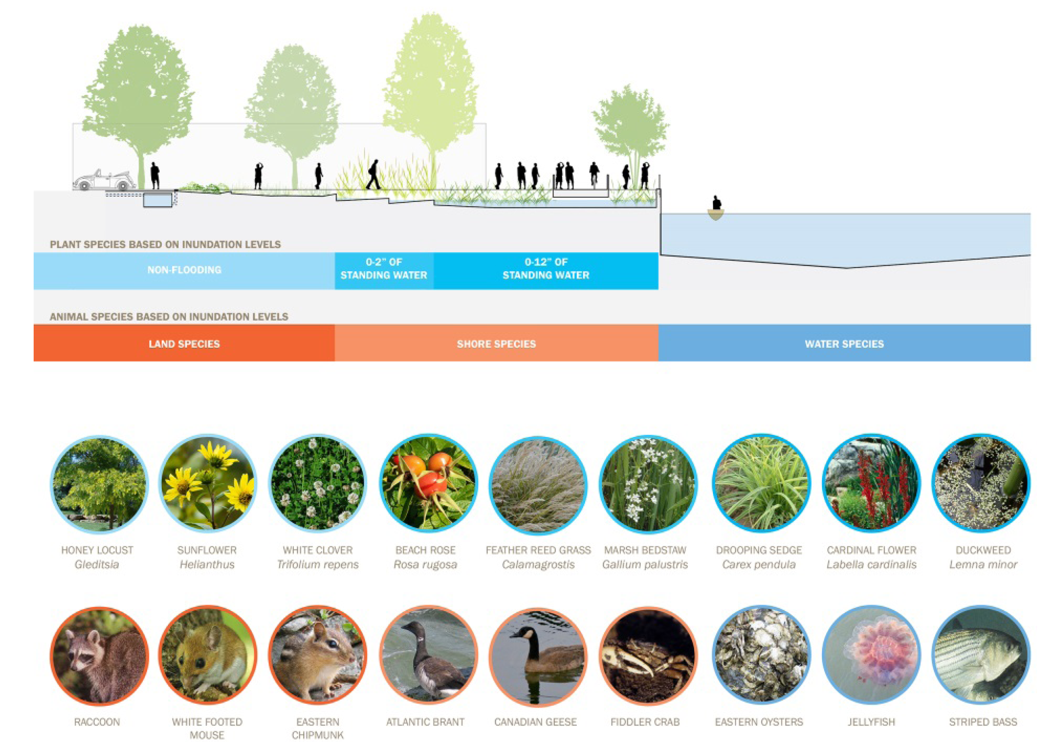
25]. In response, Susannah Drake of dlandstudio, proposed turning water that had been viewed as a waste into an asset, through a strategy she calls a “Sponge Park.” The park consists of a series of planted pits that collect storm water (
Figure 2).
Figure 2.
Sponge Park Ecology. This image illustrates the relationships of plants and animals to the Gowanus Canal (Source: dlandstudio).
Figure 2.
Sponge Park Ecology. This image illustrates the relationships of plants and animals to the Gowanus Canal (Source: dlandstudio).
According to Johnna Rizzo, Sponge Park works through five measures: gravity pulls rain runoff from the sloped street into the Sponge Park; water is absorbed and filtered by a gravel basin under sidewalks; excess flows to plant pits, where it is stored in air pockets in sandy soil and later gets absorbed by plants or drains into groundwater; any unabsorbed water is funneled to the sand filter under a pedestrian path; and excess water flows directly into the canal [
25].
Construction of the first phase of the Gowanus Sponge Park began in early 2014 and is expected to be complete in the summer of 2015. According to Karissa Rosenfield, the “
multi-use park lining the polluted canal will be anchored by soil-filled concrete cells that will retain and filter storm water, while topped with plants capable of soaking up excess water and naturally absorbing or breaking down toxins, heavy metals, and contaminants from sewage overflow” [
26]. As a result, an urban environmental liability will be transformed into a community asset.
The Gowanus Sponge Park will provide new green infrastructure for Brooklyn. Ecosystem services, including improved water quality and open space, are provided. Sponge Park is an example of an urban landscape approach design in that it combines biophysical and sociocultural concerns and outcomes.
5. Connecting the Dots
Waller Creek in Austin has experienced different abuse than the Gowanus. The Austin creek is not as poisonous as its Brooklyn counterpart. Subject to flooding, the Waller Creek corridor is fragmented and neglected. The flooding had resulted in the loss of life (35 people in 1915 and 13 more in 1981) and limited development along the eastern edge of downtown Austin. In 2011, construction of a $144 million flood diversion tunnel was began which was completed in 2014. To capture the additional values resulting from the reduction of flooding threats, the City of Austin and Travis County created a Tax Increment Financing (TIF) District. To create a coordinated vision for the TIF, the non-profit Waller Creek Conservancy was formed. Meanwhile, the University of Texas at Austin produced plans and designs for the portions of the creek that flowed through its campus.
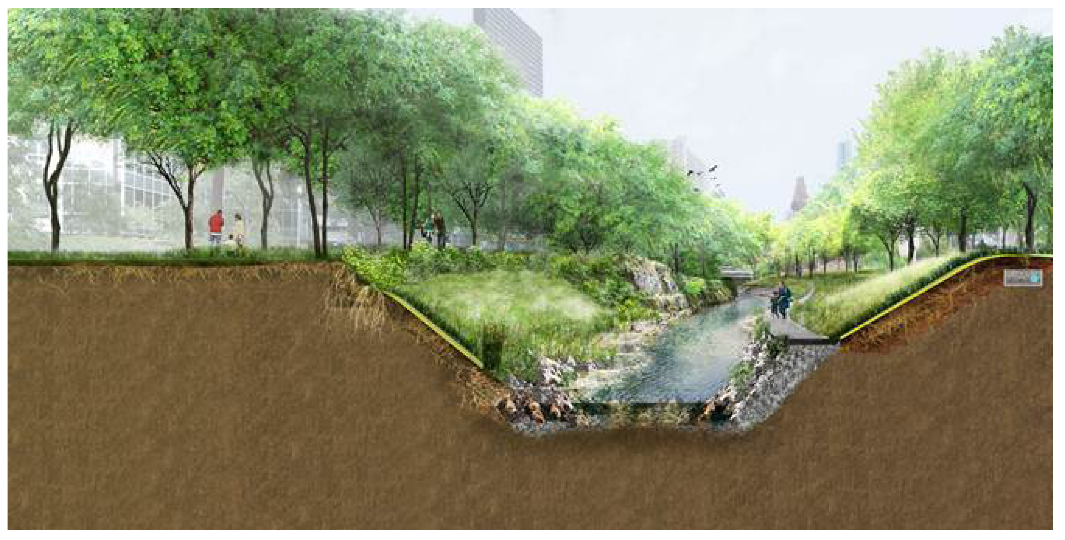
In 2012, the Waller Creek Conservancy organized an international competition to design the creek corridor. The competition brief emphasized a landscape approach. A multidisciplinary team led by Michael Van Valkenburgh Associates won the competition to convert the 1.5 mile (2.4 km) stretch from a neglected corridor into a vibrant district. Their design features a linear chain of parks connected to five distinct neighborhood districts (
Figure 3). The idea is to connect these green spaces by the corridor established by the stream channel. In addition, the scheme seeks to connect people and the environment. An objective of the Michael Van Valkenburgh Associates’ design is to create “an outdoor laboratory of urban ecology”. To accomplish this goal, their design reframes the newly engineered creek as an ecological system in the heart of the city.
Figure 3.
Waller Creek Cross-Section. (Source: Michael Van Valkenburgh Associates, Inc.).
Figure 3.
Waller Creek Cross-Section. (Source: Michael Van Valkenburgh Associates, Inc.).
Meanwhile, upstream from the TIF, Waller Creek runs through the University of Texas campus. In the university’s 2013 master plan, much emphasis is placed on transforming Waller Creek and connecting it to the Van Valkenburgh Associates’ chain of parks. The university’s lead consultant, Sasaki Associates, sought to make hydrological, ecological, and transportation connections. For example, Sasaki worked with Van Valkenburgh to connect pedestrian and bicycle paths.
The university’s master plan helped direct the design of a new medical school district, which straddles Waller Creek. This presented an opportunity to link the medical school with the northernmost of Van Valkenburgh’s chain of parks. The city and the university simultaneously undertook urban landscape initiative to improve the Waller Creek environment. As a result, ecosystem services, including recreation, wildlife habitat, and water quality will be provided.
