Article

Integrating Limiting-Factors Analysis with Process-Based Restoration to Improve Recovery of Endangered Salmonids in the Pacific Northwest, USA

1
Bren School of Environmental Science & Management, University of California Santa Barbara, Santa Barbara, CA 93106, USA
2
Cardno, Inc., 801 Second Avenue, Suite 700, Seattle, WA 98104, USA
3
Northwest Fisheries Science Center, NOAA Fisheries, 2725 Montlake Blvd E, Seattle, WA 98112, USA
4
SCR Environmental; Winthrop, WA 98862, USA
*
Author to whom correspondence should be addressed.
Water 2016, 8(5), 174; https://doi.org/10.3390/w8050174
Submission received: 1 February 2016 / Revised: 14 March 2016 / Accepted: 6 April 2016 / Published: 28 April 2016

Abstract

:
Two approaches to ecological restoration planning, limiting-factors analysis and process-based restoration, are employed in efforts to recover endangered salmonid species throughout the Pacific Northwest of North America. Limiting-factors analysis seeks to identify physical limitations to fish production that may be addressed by habitat restoration; it is known as the “Field of Dreams” hypothesis (i.e., if you build it, they will come). Process-based restoration, in contrast, assumes that protection and/or restoration of watershed-scale processes will best achieve self-sustaining habitat features that support salmon populations. Two case studies from the Columbia River basin (northwestern USA) display current efforts to integrate these two restoration approaches to improve salmonid populations. Although these examples both identify site-specific habitat features to construct, they also recognize the importance of supporting key watershed processes to achieve restoration goals. The challenge in advancing the practice of restoration planning is not in simply acknowledging the conceptual benefits of process-based restoration while maintaining a traditional focus on enumerating site-specific conditions and identifying habitat-construction projects, but rather in following process-based guidance during recovery planning and, ultimately, through implementation of on-the-ground actions. We encourage a realignment of the restoration community to truly embrace a process-based, multi-scalar view of the riverine landscape.

1. Introduction

Effective planning and recovery of endangered species face multiple challenges. Long recognized by practitioners and academics alike, these challenges include:
  • the complexity of natural systems,
  • the limitations of contemporary scientific knowledge,
  • the interplay of ecosystem degradation at multiple spatial and temporal scales,
  • the relative ease of recognizing and solving purely symptomatic problems,
  • the logistical and financial difficulty of taking actions at large spatial scales,
  • the social urgency for taking immediate actions that show rapid results, and
  • the visibility and appeal of discrete habitat-restoration projects.
After many decades of theory and practice in the pursuit of river restoration, we have come to recognize two broad approaches to restoration planning and implementation, fundamentally different in their perspectives and approaches, but commonly sharing the same ultimate goal, namely the recovery of endangered aquatic species across a human-disturbed landscape. Our objectives are to articulate the attributes of these two approaches, to explore how they can each support the other’s limitations, and to present two ongoing examples of salmonid recovery planning in the Pacific Northwest of North America, where the challenges and the opportunities presented by integrating these perspectives are particularly well-expressed.

2. Limiting-Factors Analysis

The first, “bottom-up” approach proceeds from the long-standing paradigm that when habitat required by a species during a particular season or life stage is in short supply, a bottleneck results. The shortage of this habitat thus limits the system’s full potential for supporting the selected organism. Other factors can also limit the size or growth of a population, but this approach is explicitly focused on habitat. As first articulated by Reeves et al. [1], “[Physical limiting-factors analysis] is designed to identify potential physical limitations to fish production that may be moderated or removed by habitat rehabilitation or enhancement programs.” The obvious solution to an identified limiting habitat is simply to restore it where it has been lost (or to reconstruct it, if restoration is not possible), and much of the current stream and river restoration industry is dedicated to the construction of physical habitats. As commonly implemented, however, a limiting-factors analysis can simply comprise a list of habitat impairments (e.g., [2,3]) without the necessary population-scale analysis to identify the habitat types most important for species or ecosystem recovery, or the determination of whether those identified limiting factors are only symptomatic of more fundamental impairments.
Simply building more habitat without a clear understanding of its role in the life history of the target species, however, is unlikely to be successful. This approach was dubbed the “Field of Dreams” hypothesis by Palmer et al. [4] (i.e., if you build it, they will come). Hildebrand et al. [5] included it as the second in their list of five myths of restoration, ascribing its origins “…from the notion that all one needs is the physical structure for a particular ecosystem, and biotic composition and function will self-assemble”. Case studies have typically emphasized the poor success in achieving measurable biological gains solely through manipulation of physical habitat, particularly in the absence of any broader analysis of whether that habitat is truly limiting from a population perspective. Such outcomes have been reported from a variety of locations and watershed contexts, particularly channels in highly disturbed urban watersheds where altered flow regimes and water chemistry are typically as or more impacted than physical habitat (e.g., [6,7,8,9,10,11]; Figure 1). In less disturbed watershed settings, results are commonly more biologically successful, but rarely do they approach full recovery of the instream and biological conditions found in fully undisturbed settings (e.g., [12,13,14,15,16,17,18]).
Miller et al. [19] conducted a meta-analysis of 24 published studies, covering 89 individual restoration sites world-wide with pre- and post-project monitoring data judged by them to be adequate to evaluate the biological response to restoration efforts. Metrics of macroinvertebrate communities [20] were used to quantify that response. Their results support a hypothesis that increased physical habitat heterogeneity can enhance macroinvertebrate richness (although not density). However, they also found that land use and other watershed-scale conditions exerted a strong influence on macroinvertebrate responses, attributes for which habitat restoration projects are unable to influence.
Roni et al. [21] also conducted a literature review to identify documented responses (physical, chemical, and/or biological) to a wide range of restoration practices. The scope of the evaluated actions was broader than that of Miller et al. [19], and although its constituent studies tended to mirror Miller et al.’s reported minimal responsiveness of macroinvertebrates to physical habitat changes, they also commonly reported increases in fish abundance (particularly for salmonids) following instream habitat restoration. The authors of [21] cautioned, however, that such physical habitat improvements are typically limited in spatial extent and short-lived, and they noted that these shortcomings might be avoidable but only when instream actions are coupled with riparian planting or other process-based restoration activities.
The limiting-factors approach has clear benefits for restoration planning and restoration implementation. It promises direct, mechanistic links between restoration actions, habitat creation and (presumptive) increases in fish populations. The main underlying assumption is that if any key life stage is suppressed by diminished habitat factors, then resolution of that bottleneck will produce the greatest improvement in the population as a whole. However, it also has several other less obvious assumptions: that the mechanistic links are well known, that the identified limiting factor is in fact limiting for both the organism’s targeted life stage and the population as a whole, and that the construction of new habitat features provides commensurate habitat functions that will persist in the environment without continued human intervention. As commonly implemented, this approach relies on either conventional wisdom about the presumptive limiting life stage and impaired habitat, or on fish population models to identify the key life stage(s) and their necessary habitat(s) (although these models, at their root, may also be based on common wisdom [22]).
This approach was first described for use at the watershed scale, matching the scale at which salmon populations use habitats in a river basin throughout their life cycle (e.g., [1,23]). However, it is most typically invoked to identify and justify the construction of site-specific restoration structures throughout rivers and streams of the Pacific Northwest today [24,25], even though a true limiting factor cannot be identified with confidence at spatial scales smaller than that of the salmon population’s range.
The utility of the concept of limiting factors has been further hampered by difficulties in quantifying how the condition or carrying capacity of a given freshwater habitat component translates into increasing the growth, survival and reproductive success of salmon throughout their life history. Recent advances in field techniques (e.g., the use of passive integrated transponders to track the fate of individual juvenile and adult fish, or inexpensive continuous temperature monitors) are being put to good use to develop those critical relationships. Coupling this empirical field-derived data with recent advances in salmon life cycle models (e.g., [26,27]) should allow for more explicit understanding of the role that freshwater and estuarine habitats play in limiting key life history stages of native salmon throughout their range. Absent this broad-scale guidance, however, this approach may not successfully identify the factors that truly limit a species’ population.

3. Process-Based Restoration

The second, “top-down” approach to aquatic restoration planning embraces the principles of process-based restoration [28,29]. Studies guided by these principles pursue a hierarchical understanding of streams in their watershed context to guide stream restoration planning, advocating that the protection and/or restoration of watershed-scale processes should, in general, supersede the restoration of strictly reach-scale conditions. Beechie et al. [28] grouped these watershed-scale processes under the categories of hydrology, sediment, riparian, channel, floodplain connectivity and water quality. Subsequently, Beechie et al. [29] recommended “…reestablish[ing] normative rates and magnitudes of physical, chemical, and biological processes that sustain river and floodplain ecosystems,” emphasizing that “restoration actions should address the root causes of degradation…” (p. 209).
A salmon recovery program guided by these principles therefore would need to identify (1) watershed areas with a disproportionate influence on the key watershed processes (in particular, the delivery of water and sediment) that sustain rivers and streams; (2) valley segments that express dynamic habitat-forming processes (e.g., channel migration zones) and sustain channel–floodplain interactions; and (3) reaches with component features that hold particularly high actual or potential for biological use in both the channel and the riparian zone. This is a multi-scalar approach, placing a higher priority on protecting the natural functions of key watershed, valley and riverine zones than on efforts to rebuild those structures at single, site-specific locations.
Although this perspective has been explicitly invoked in many of the recent restoration planning documents in the Pacific Northwest, its implementation in practice is far more challenging than its widespread embrace by the scientific restoration literature might suggest. Its advantages are obvious: it emphasizes addressing the causes of degradation rather than the symptoms, and it invokes self-sustaining watershed and riverine processes to maintain conditions that might otherwise be a source of long-term maintenance or outright project failure. However, it also assumes that restoring normative watershed processes can create and support desired habitat features (and the species that occupy them), whether or not we fully understand any of the linkages between the watershed and its stream reaches.
A classic example of the differences in implementing restoration projects under the guidance of a limiting-factors analysis vs. process-based restoration is illustrated from the perspective of large woody material (LWM). Low amounts of instream LWM (Figure 2) are a commonly documented impact to Pacific Northwest rivers and streams that can directly impact one or more of the critical life stages of salmonids [30]. From a liming-factors perspective, the solution is obvious: if low LWM loads are identified as the overriding problem of degraded habitat, then adding wood to rivers is the logical solution, around which a mature practice has developed for the placement of individual logs and engineered log jams [31,32]. Process-based restoration would look instead to the ultimate source of that wood, replanting riparian forests and allowing lateral migration of the active channel to provide a sustainable source of logs over the long term and the geomorphic mechanism needed to bring them into the river.
These two approaches are not mutually exclusive, at least in principle: a long-term riparian replanting program to restore wood recruitment could be supplemented (or jump-started, in popular parlance) by logs and log structures intended to last several decades, but not necessarily forever, to achieve both certain short-term and potential long-term benefits. In our experience, however, restoration planning (and its subsequent implementation) is typically focused on only one or the other of these perspectives, depriving the region of benefits that could accrue by a more conscious attention to both and potentially saving significant dollars otherwise expended on projects that ultimately prove ineffectual or ephemeral.

4. Case Studies

The goals of restoration planning are broadly similar across any landscape: to identify feasible actions that achieve maximum benefit for the ecosystem in general and for species of concern in particular. The approach and the scale of that planning will be determined by a variety of local conditions, however: not only physical and biological, but also social, legal and economic. In the Columbia River basin of Idaho and eastern Oregon and Washington states, USA (Figure 3), intensive restoration planning and implementation is being undertaken in response to massive impacts to fish populations and their habitats from hydroelectric and water-supply dams throughout the Columbia River watershed, together with more than a century of adverse land-use impacts [33]. Two examples, both in progress as of early 2016, are exploring how best to meet these overarching goals. Although implemented at very different spatial scales, they are both integrating the two restoration approaches discussed here, limiting-factors analysis and process-based restoration. Their progress to date is providing useful examples of how the conscious incorporation of these two approaches can improve the implementation of restoration planning region-wide.
Although imposed geographical constraints or financial limitations may constrain the scope of meaningful analyses to support restoration planning, we believe that the legacy of traditional restoration practices presents a more serious limitation on achieving truly effective, science-based outcomes. This “social” limitation has been recognized for more than a decade: Pullen et al. ([34], p. 245) noted that “the majority of conservation actions remain experience-based and rely heavily on traditional land management practices,” while Sutherland et al. ([35], p. 305) found that “Much of current conservation practice is based on anecdote and myth rather than on the systematic appraisal of the evidence.” These authors supported their contention with a survey of conservation practitioners, finding that more than three quarters of their sources of information and guidance were anecdotal (namely, “common sense”, “personal experience” and “speaking to other managers”). In contrast, only 2% of mentioned sources comprised primary scientific literature. The following case studies thus suggest what can be accomplished when guided by current scientific understanding, but they do not guarantee an optimal outcome in every application.

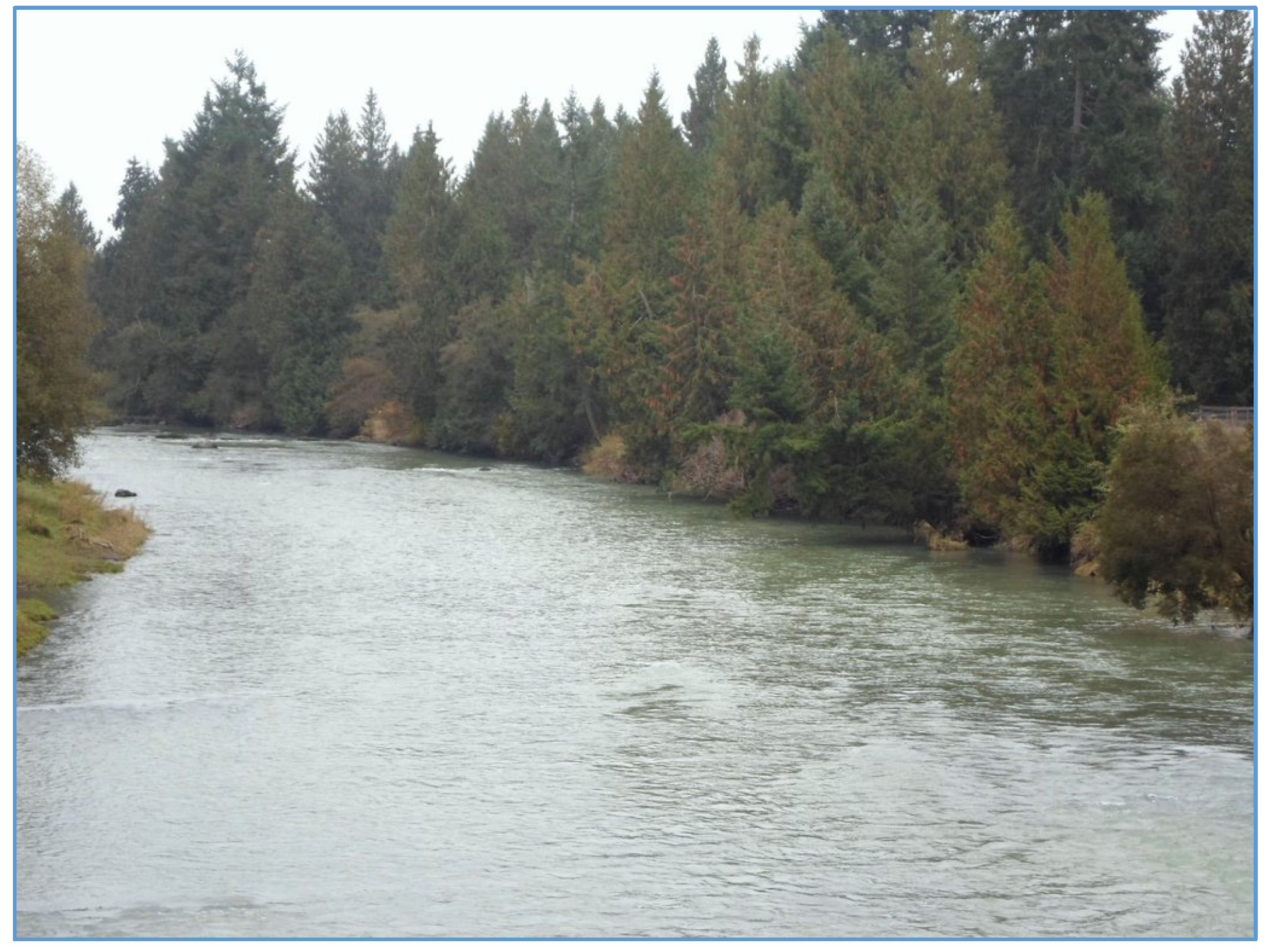
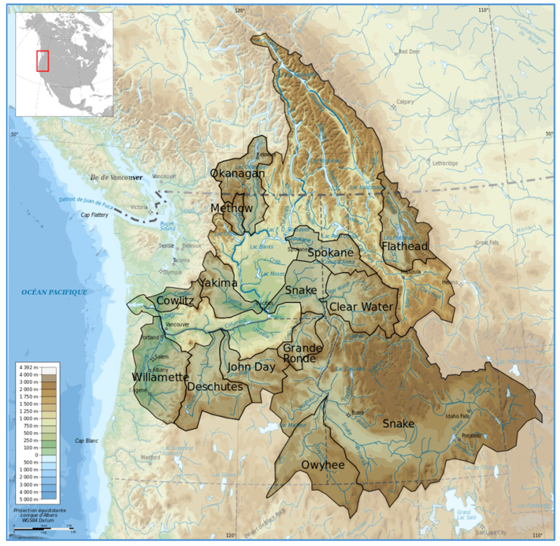
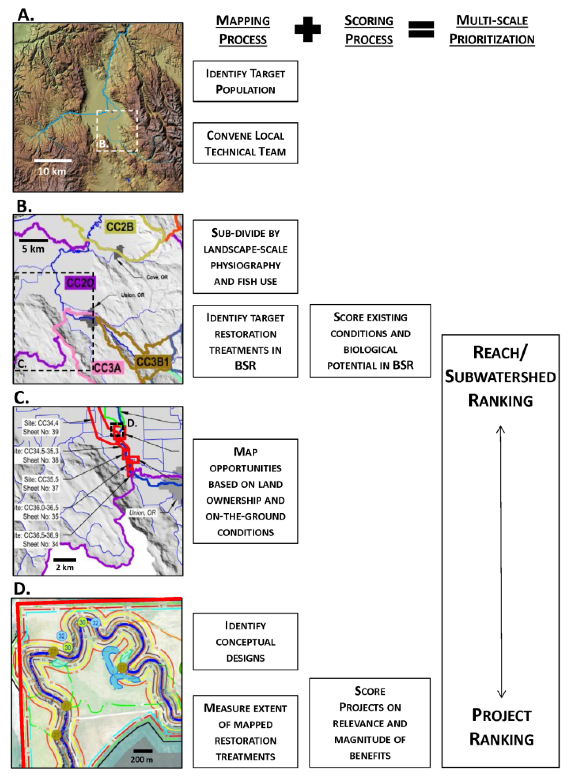
4.1. Reach Assessment along the Methow River

In response to requirements under the 2014 Biological Opinion issued by NOAA Fisheries, the US Bureau of Reclamation (USBR) is working to rehabilitate habitat for anadromous fish species in specific tributaries to the Columbia River System. As such, for more than a decade USBR and NOAA have agreed on an approach with early-stage restoration planning efforts that include river-specific reach assessments to “document and assess reach-scale features and processes for the purpose of identifying suitable habitat recovery actions that address known limiting factors within the reach” [36]. The associated guidance describes a systematic structure for these reach assessments to describe historical, existing and target conditions, followed by the identification of “potential actions to preserve, initiate and/or create the identified target conditions.” Although there is no a priori limitation on the scale of such actions, the geographic scale of the assessed river reaches (no more than a few 10s of km) strongly implies a local focus for such actions.
The restoration actions recommended in such reach assessments are typically at a similarly limited spatial scale. For example, the reach assessment for the Middle Twisp River [37] (a major tributary of the Methow River, a right-bank tributary to the Columbia River in the northwest corner of the basin; see Figure 3) specifies the placement of structural habitat elements as its most common recommendation, followed by habitat reconnection via infrastructure modifications, off-channel habitat enhancements and riparian restoration. In the Grays reach assessment [25] (on the Entiat River, a Columbia River tributary between the Methow and Yakima subwatersheds), the summary of its recommended actions is almost entirely site-specific in application: engineered logjams, rock and log barbs, boulder clusters, enhancing existing channels via excavation, planting riparian vegetation, fencing and bank stabilization.
As an alternative approach, an explicit integration of the principles of process-based restoration into the spatially-limited scope of a reach assessment is currently (early 2016) being undertaken on the 21-km-long Twisp to Carlton reach of the Methow River (described in http://www.ccfeg.org/current-projects/studies-and-assesments/twisp-to-carlton-reach-assessment/). This work is being executed under the premise that enhancement of key habitat-forming processes is the only sustainable course for improving habitat conditions targeted at specific species. Field work and map analyses therefore have emphasized the identification, distribution and magnitude of the watershed processes that create and sustain river and floodplain ecosystems [29] and the specific locations where they have been impaired by human activities. The overall conditions of the instream habitat were determined from a rapid, synoptic survey (Figure 4), a departure from the common industry practice of detailed mapping of habitat features. Such feature-mapping remains the standard for many reach assessments, despite the facts that they are labor- and cost-intensive and offer only limited additional guidance for identifying restoration actions that would support critical processes and conditions. Habitat-improvement projects were identified and prioritized along the Twisp to Carlton reach, but only within the explicit guidance from this framework; namely, identified actions are designed to restore (or protect) watershed processes, not simply to create habitat features.
The study followed a sequence of analyses, of which the first was engaging local and regional fisheries experts to develop a prioritized list of ecological concerns (as defined by [38], ecological concerns are the specific impairments to habitat that influence the productivity and abundance of salmonids, and that restoration projects are meant to address). Subsequent steps were to determine the impaired processes most likely responsible for those concerns and to identify actions that could improve those impaired processes, even if implemented only at the scale of the reach rather than across the watershed as a whole.
Emphasizing the condition of key watershed processes provides a more comprehensive lens for evaluating river/riparian conditions within the watershed. Its implementation, here or elsewhere, includes the identification of locations where near-natural rates and patterns of river and riparian processes are well expressed and are largely unaffected by human activities and infrastructure (e.g., Figure 5), as well as those areas likely to benefit from more active restoration. For those areas with intact processes, protection is likely to be the most appropriate restoration “action.” Elsewhere, discrete areas where natural processes of river migration and LWM input have been highly constrained would likely benefit from actions to resolve those constraints, rather than simply creating localized habitat features in the absence of long-term processes necessary to sustain them. Though well intentioned, the long-term effectiveness of such habitat construction has generally been found to be rather low, as demonstrated by a variety of studies spanning more than a quarter century (e.g., [39,40]. As such, small-scale habitat-improvement projects provide limited long-term benefit to ecosystem restoration, even though they are the most common products of nearly all such assessments.
Evaluating the Twisp to Carlton reach from the perspective of watershed processes has highlighted the value of restoring three key watershed processes that presently experience significant, widespread impairment here. Their enhancement is likely to have multiple benefits for species of concern here and elsewhere, given the types of habitat limitations that have previously been identified:
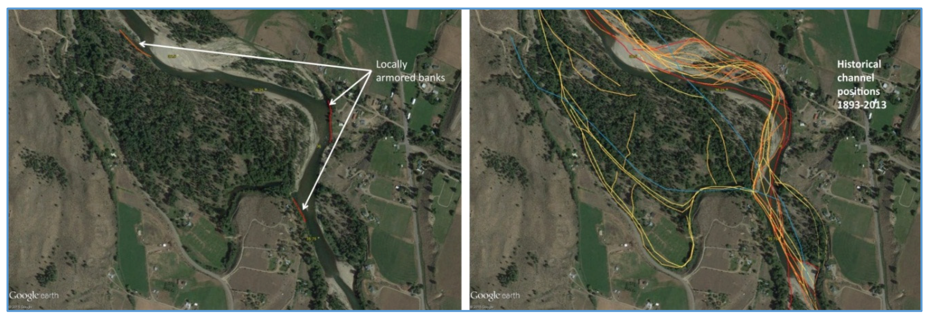
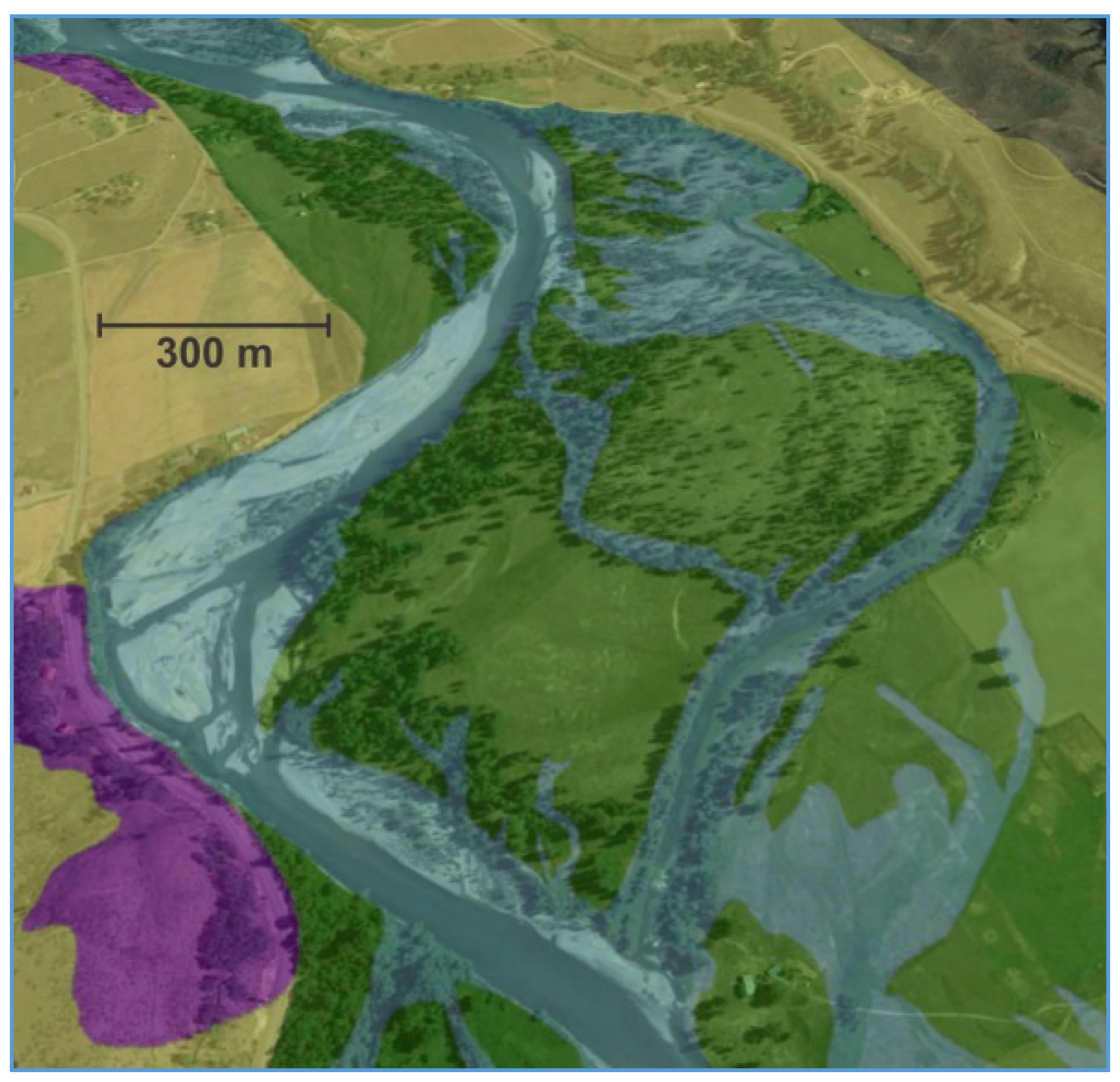
  • Channel migration: Enhancement can be accomplished through the removal of artificial constraints to lateral channel migration (bank armoring, levees) and reconnection of floodplain features. The benefits are in allowing the river to re-occupy historical floodplain surfaces, expanding the seasonal availability of off-channel habitats to support juvenile salmon, recharging hyporheic flow pathways, promoting floodplain forest rejuvenation, and developing greater hydraulic (and thus habitat) complexity and nutrient flux within the reach (Figure 6).
  • Riparian vegetation community succession: Enhancement can be accomplished by riparian forest replanting along riverfront properties secured through landowner grants, conservation easements or fee-simple purchase. Benefits are in providing increased inputs of terrestrial insects and organic materials, supporting the long-term recruitment of LWM, increasing riparian shade and improving bank cover along existing channel margins to improve juvenile foraging and cover/holding habitat.
  • Hydraulic complexity within the main channel: Enhancement can be primarily accomplished through the long-term restoration of channel migration and riparian succession, but potential short-term enhancement can also occur through boulder-cluster and LWM placements. Benefits are in creating a greater variety of habitats for increasing juvenile rearing and foraging, facilitating adult holding and migration and providing a greater range of refugia during periods of high flow or high temperature.
Specific actions recommended by the reach assessment are derived directly from identification of these impaired processes, with a recognized hierarchy from large-scale to site-specific actions:
  • Protect remaining areas of intact in-channel habitat and riparian corridors from future human development or other disturbance: making use of conservation easements, purchase or other landowner agreements.
  • Improve overall channel–floodplain connectivity: levee and revetment removal and beaver reintroduction.
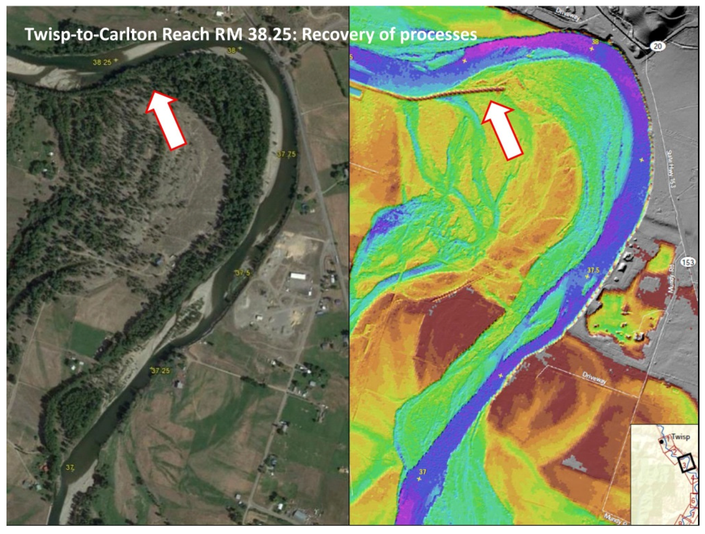
  • Reconnect relic side channel and backwater features: identifying areas where now isolated shallow backwater and recently active floodplain areas present opportunities to reconnect these features back to the main river (Figure 7).
  • Enhance cool-water locations (e.g., upwelling areas, cool-water tributary junctions and off-channel/wetland complexes): such areas may be suitable for both passive (i.e., protection) and active restoration.
  • Modify existing levees: in sections of the river that are severely constricted by levees, investigating whether sections of existing levee can be set back to allow the river to re-occupy some historical meander through these sections.
  • Reestablish an active riparian zone: identifying shoreline areas where no bank armoring and active erosion afford an opportunity for long-term re-establishment of historical native willow and cottonwood gallery forests.
  • Increase instream habitat complexity in long, simplified riffle sections and in highly constrained sections: installing wood jams and/or boulder clusters (both present but sparse in the reach) to provide some modest increase in the habitat complexity that naturally-occurring obstructions once afforded and mimicking the conditions associated with the only remaining deep pools in the entire reach (unconstrained meander bends and bedrock outcroppings).
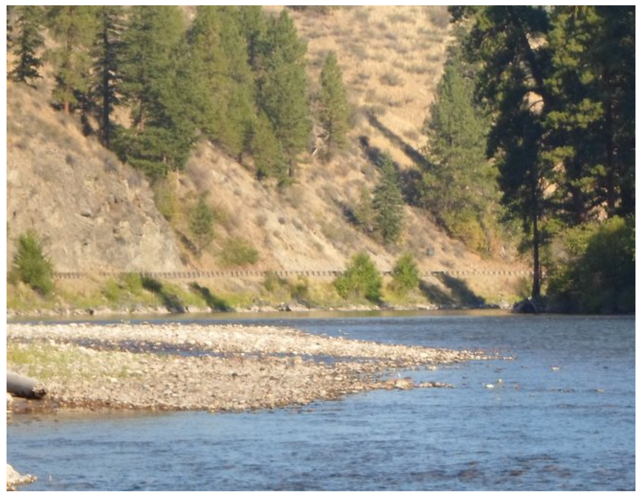
  • Soften existing rip-rap by modifying with wood: installing instream wood structure deflectors or other such features to give more roughness and structural complexity, where more extensive treatments are infeasible (Figure 8).
A reach assessment, despite its nominally limited scale and scope, can nonetheless identify watershed processes that are critical to the maintenance of diverse habitats and that have been significantly impaired by past human actions. Although the approach taken by the Twisp to Carleton reach assessment is, fundamentally, a process-based approach, it also embraces the foundational assumption of limiting-factors analysis, namely that site-specific habitat improvements (with the goal of resolving impaired processes) will contribute to increasing carrying capacity for juvenile and sub-adult Chinook and steelhead. For this integration to succeed, however, a robust identification of the population-scale limiting habitat conditions is essential to guide the analysis of which processes are truly critical. Here, that guidance has been provided by an interagency regional technical team serving the Upper Columbia Basin, a valuable source of local expertise. Nonetheless, a more systematic structure that incorporates a broader, population-scale perspective would likely further enhance the quality and reliability of the technical guidance that is presently available.

4.2. The Atlas Prioritization Framework

Our second case study, the Atlas prioritization framework, is underway in multiple watersheds throughout the Columbia River basin. A primary goal is to integrate an analysis of habitat impairments with the sustainable attainment of properly-functioning conditions at a true watershed scale. Although still early in its implementation, this approach could serve as a successful example of engaging stakeholders and technical experts within a scientifically-valid, defensible framework for developing large-scale habitat improvement plans.
The Atlas prioritization framework is administered by the Bonneville Power Administration, marketer and distributor of hydroelectric power generated from multiple dams on the Columbia River system. It is supported by the U.S. Bureau of Reclamation and the U.S. Army Corps of Engineers, which manage these facilities. These three entities comprise the “Action Agencies” responsible for operating a series of hydropower projects located on the mainstem Columbia River and in several of its major tributaries. This system provides approximately 40% of the electricity used in the Pacific Northwest, but its operation also affects 13 species of native Columbia Basin salmon and steelhead listed for protection under the Endangered Species Act.
While the geographic extent for applying the combined Atlas prioritization framework is large, each habitat implementation action is designed to incorporate local science and stakeholder engagement, including Native American Indian Tribes, federal, state, county and non-profit organizations who commonly sponsor implementation of the identified restoration actions. The framework aims to coordinate efforts of all stakeholders within a given watershed (including research and monitoring efforts from local scientists) to systematically address required habitat needs and to efficiently facilitate recovery actions [41]. Thus, it can incorporate physical, biological and social information to identify the types and locations of potential restoration project actions intended to improve habitat functions for these critically-endangered salmonids.
The Atlas prioritization framework ranks potential restoration actions by use of a structured approach to identify, map and score restoration opportunities within a hierarchical spatial framework (Figure 9). Beginning with a target salmonid population at a regional scale, an advisory group of local technical experts, practitioners and sponsors is convened to divide the watershed of interest into biologically-significant reaches (BSRs). BSRs are intended to reflect subwatersheds of relatively consistent geomorphology and fish use, over which a single scoring scheme for project opportunities can credibly be applied. Based on the members’ judgment of empirical data, habitat impairments and known fish use at various life stages, the advisory group evaluates existing conditions and geomorphic potential to score each BSR to produce a tiered ranking of subwatershed restoration priority.
An increasingly important aspect of understanding this physical, chemical and biological system is the incorporation of the human landscape into the process of overall restoration analysis and planning. Thus, the advisory group also evaluates prospective restoration actions based on known opportunities and constraints imposed by human activity and land ownership, grounding the process in an understanding of pragmatic constraints as well as physical conditions. Conceptual designs of potential restoration actions are then mapped for each opportunity and compiled into a map book, or atlas, of project designs that provides a vision of potential projects across all BSRs within the broader watershed. This atlas also contains a list of restoration opportunities quantified by biological benefit and the extent of each project, allowing them to be scored relative to the priority restoration actions for the encompassing BSR. The outcome of this process is a hierarchical prioritization at the scales of both subwatersheds (and the BSRs that they contain) and individual projects within each BSR, with the intent to use those rankings in concert to objectively guide multiple, simultaneous restoration actions at a watershed and target population scale.
The narrative description of the Atlas prioritization framework identifies it as a limiting-factors approach, and there is no intrinsic requirement that the evaluation process makes use of any systematic assessment of life-cycle requirements or true population bottlenecks. However, the spatial scales of both the compiled data and their subsequent analysis support a systematic assessment of key watershed processes, and the potential to restore processes that create and maintain habitats and biota (sensu [29]) are explicitly recognized in the guidance for ranking opportunities within individual BSRs (Step C of Figure 9). Linking the identified restoration opportunities with the processes necessary for their long-term sustainability could suggest entirely new types of restoration actions, particularly those more closely associated with the underlying causes of habitat degradation. This could include large-scale protection of relatively undisturbed landscape areas (e.g., via conservation easements), watershed-scale restoration of process-disrupting features far outside of the channel itself (e.g., road decommissioning in industrial forestlands) and removal of constraining levees and revetments. Each of these types of restoration actions serves to enhance the natural expression of habitat-forming processes that would ultimately be more sustainable.
It is too early to conclude that this framework will actually result in a successful integration of these two restoration perspectives in every application, or merely present the possibility of such an integration. Nonetheless, some of the initial recommendations emerging from the framework are embracing a multi-scalar approach to restoration and a clear focus on restoring processes, and not just features. We therefore believe that it offers a promising path to combining these approaches.

5. Discussion: Integrating Restoration Planning Approaches

The value of a process-based restoration framework is not particularly novel; much of its foundation was articulated many decades ago (e.g., [42]). The potential for integration with more localized site-specific treatments has also been previously recognized, such as the following decade-old list of recommended questions to guide habitat restoration planning (from [43]):
  • Are there barriers to colonization? How can potential barriers be overcome?
  • Do the target species have particular habitat requirements at different life stages? What are they? How should these habitats be arranged spatially?
  • Are there introduced species that may benefit disproportionately to native species from habitat restoration?
  • How are long-term and large-scale phenomena likely to influence the likelihood or timeframe of responses to habitat restoration?
  • What size habitat patches must be created for populations, communities and ecosystem functions to be restored?
Only one of these questions (#2) focuses directly on limiting factors and the potential benefits of habitat reconstruction. The balance of these questions, however, anticipates what we now term process-based restoration, including the necessary scale of an analysis (#4) and the movement within that broader domain of both water and organisms (as invoked by #1). These questions also remind us that the size of necessary habitat patches may be well beyond the scope of most habitat restoration projects (#5) and that neither habitat construction nor process protection can always return impacted systems to a fully-natural, “restored” state, particularly when a new biological community has been established in the interim (#3) [44].
Our two case studies illustrate how some of this historical understanding of restoration approaches is now being applied throughout the region, even if their integration has not always been deliberate. For example, the Bureau of Reclamation had previously stated in its earlier reach assessment [24], also on the Methow River and immediately upstream of the Twisp to Carlton reach, that the work was explicitly intended to resolve limiting factors through the reach. However, the project prioritization of that reach assessment in fact followed the guidance of process-based restoration (as articulated in [28]) almost verbatim:
  • Protect and maintain current habitat,
  • Reconnect isolated habitat,
  • Reconnect processes, and
  • Reconnect isolated habitat units (also including the construction of new habitat features) ([24], pp. 43–44).
A similar (but more conscious) integration is being attempted under the Atlas framework. Its fundamental guidance is that of a limiting-factors analysis, ideally but not necessarily supported by population modeling. Its intentionally broad watershed-scale invites a more comprehensive view of watershed conditions (and subsequently of recommended actions), however, than just that of prioritizing site-specific habitat project opportunities.
We therefore believe that the challenge in advancing the practice of restoration planning is not in simply accepting the framework of “process-based restoration” as a worthy goal, because this is already commonplace. Instead, it is in finding the structure, and enforcing the discipline, to follow the guidance of this framework during the recovery-planning process and, ultimately, through on-the-ground implementation [40,45]. This will also require that current reach and watershed assessment guidelines allow more flexibility in their application to specific circumstances. We encourage not only a broader view of what constitutes a meaningful restoration “project”, but also a realigning of the river restoration community to truly embrace the top-down, multi-scalar, process-based view of the riverine landscape. Doing so will improve the likelihood that the continuing significant expenditure of public funds in pursuit of the recovery of native salmonids will actually yield sustainable results.

Acknowledgments

The authors appreciate the engagement of other scientists and stakeholders throughout the Columbia River basin for their interest and participation in the case studies described here. Support for the field work and initial data analysis on the Twisp to Carlton reach assessment was provided by the Cascade Columbia Fisheries Enhancement Group for DBB and SCR. The authors also thank BPA for permission to reference the Atlas prioritization framework and for the participation of Bureau of Reclamation, JGS, and many local partners in the Upper Grande Ronde Atlas development. We also thank three anonymous journal reviewers, whose comments on the initial draft led to significant improvements in our organization and presentation of this work.

Author Contributions

All authors participated in the joint conception and development of this discussion. DBB and SCR conducted the field work in the Twisp to Carlton reach. JGS participated in the Atlas prioritization framework for the Upper Grande Ronde watershed of the Columbia River basin. All authors participated in the final development and writing of the manuscript.

Conflicts of Interest

The authors declare no conflict of interest.

References

  1. Reeves, G.H.; Everest, F.H.; Nickelson, T.E. Identification of Physical Habitats Limiting the Production of Coho Salmon in Western Oregon and Washington; General Technical Report PNW-GTR-245; U.S. Department of Agriculture, Forest Service, Pacific Northwest Research Station: Portland, OR, USA, 1989; p. 18.
  2. Andonaegui, C. Salmon and Steelhead Habitat Limiting Factors Report, Entiat Watershed, Water Resource Inventory Area (WRIA) 46; Washington State Conservation Commission: Olympia, WA, USA, 1999; p. 77.
  3. Wade, G. Salmon and Steelhead Habitat Limiting Factors Report, Water Resource Inventory Area 27; Washington State Conservation Commission: Olympia, WA, USA, 2000; p. 120.
  4. Palmer, M.A.; Ambrose, R.F.; Poff, N.L. Ecological theory and community restoration ecology. Restor. Ecol. 1997, 5, 291–300. [Google Scholar] [CrossRef]
  5. Hilderbrand, R.H.; Watts, A.C.; Randle, A.M. The myths of restoration ecology. Ecol. Soc. 2005, 10, 19. [Google Scholar]
  6. Larson, M.L.; Booth, D.B.; Morley, S.M. Effectiveness of large woody debris in stream rehabilitation projects in urban basins. Ecol. Eng. 2001, 18, 211–226. [Google Scholar] [CrossRef]
  7. Suren, A.M.; McMurtrie, S. Assessing the effectiveness of enhancement activities in urban streams: II. Responses of invertebrate communities. River Res. Appl. 2005, 21, 439–453. [Google Scholar] [CrossRef]
  8. Scholz, N.L.; Myers, M.S.; McCarthy, S.G.; Labenia, J.S.; McIntyre, J.K.; Ylitalo, G.M.; Rhodes, L.D.; Laetz, C.A.; Stehr, C.M.; French, B.L.; et al. Recurrent die-offs of adult coho salmon returning to spawn in Puget Sound lowland urban streams. PLoS ONE 2011, 6, e28013. [Google Scholar] [CrossRef] [PubMed]
  9. Sudduth, E.B.; Hassett, B.A.; Cada, P.; Bernhardt, E.S. Testing the field of dreams hypothesis: Functional responses to urbanization and restoration in stream ecosystems. Ecol. Appl. 2011, 21, 1972–1988. [Google Scholar] [CrossRef] [PubMed]
  10. Violin, C.R.; Cada, P.; Sudduth, E.B.; Hassett, B.A.; Penrose, D.L.; Bernhardt, E.S. Effects of urbanization and urban stream restoration on the physical and biological structure of stream ecosystems. Ecol. Appl. 2011, 21, 1932–1949. [Google Scholar] [CrossRef] [PubMed]
  11. Stranko, S.A.; Hilderbrand, R.H.; Palmer, M.A. Comparing the Fish and Benthic Macroinvertebrate Diversity of Restored Urban Streams to Reference Streams. Restor. Ecol. 2012, 20, 747–755. [Google Scholar] [CrossRef]
  12. Lester, R.E.; Wright, W.; Jones-Lennon, M. Does adding wood to agricultural streams enhance biodiversity? An experimental approach. Mar. Freshw. Res. 2007, 58, 687–698. [Google Scholar] [CrossRef]
  13. Coe, H.J.; Kiffney, P.M.; Pess, G.R.; Kloehn, K.K.; McHenry, M.L. Periphyton and invertebrate response to wood placement in large Pacific Coastal rivers. River Res. Appl. 2009, 25, 1025–1035. [Google Scholar] [CrossRef]
  14. Palmer, M.A.; Menninger, H.L.; Bernhardt, E. River restoration, habitat heterogeneity and biodiversity: A failure of theory or practice? Freshw. Biol. 2010, 55 (Suppl. S1), 205–222. [Google Scholar] [CrossRef]
  15. Feld, C.K.; Birk, S.; Bradley, D.C.; Hering, D.; Kail, J.; Marzin, A.; Melcher, A.; Nemitz, D.; Pedersen, M.L.; Pletterbauer, F.; et al. From Natural to Degraded Rivers and Back Again. A Test of Restoration Ecology Theory and Practice. Adv. Ecol. Res. 2011, 44, 119–209. [Google Scholar]
  16. Wellnitz, T.; Kim, S.Y.; Merten, E. Do installed stream logjams change benthic community structure? Limnologica 2014, 49, 68–72. [Google Scholar] [CrossRef]
  17. Nilsson, C.; Polvi, L.E.; Gardeström, J.; Hasselquist, E.M.; Lind, L.; Sarneel, J.M. Riparian and in-stream restoration of boreal streams and rivers: Success or failure? Ecohydrology 2015, 8, 753–764. [Google Scholar] [CrossRef]
  18. Vietz, G.J.; Rutherfurd, I.D.; Fletcher, T.D.; Walsh, C.J. Thinking outside the channel: Challenges and opportunities for protection and restoration of stream morphology in urbanizing catchments. Landsc. Urban Plan. 2016, 145, 34–44. [Google Scholar] [CrossRef]
  19. Miller, S.W.; Budy, P.; Schmidt, J.C. Quantifying macroinvertebrate responses to in-stream habitat restoration: Applications of meta-analysis to river restoration. Restor. Ecol. 2010, 18, 8–19. [Google Scholar] [CrossRef]
  20. Barbour, M.T.; Gerritsen, J.; Snyder, B.D.; Stribling, J.B. Rapid Bioassessment Protocols for Use in Streams and Wadeable Rivers: Periphyton, Benthic Macroinvertebrates and Fish, 2nd ed.EPA/841-B-99-002; U.S. EPA, Office of Water: Washington, DC, USA, 1999; p. 197.
  21. Roni, P.; Beechie, T.; Pess, G.; Hanson, K. Wood placement in river restoration: Fact, fiction, and future direction. Can. J. Fish. Aquat. Sci. 2014, 72, 466–478. [Google Scholar] [CrossRef]
  22. McElhany, P.; Steel, A.; Avery, K.; Yoder, N.; Busack, C.; Thompson, B. Dealing with uncertainty in ecosystem models: Lessons from a complex salmon model. Ecol. Appl. 2010, 20, 465–482. [Google Scholar] [CrossRef] [PubMed]
  23. Beechie, T.; Beamer, E.; Wasserman, L. Estimating coho salmon rearing habitat and smolt production losses in a large river basin, and implications for habitat restoration. North Am. J. Fish. Manag. 1994, 14, 797–811. [Google Scholar] [CrossRef]
  24. US Bureau of Reclamation. Middle Methow Reach Assessment; Pacific Northwest Regional Office: Boise, ID, USA, August 2010; p. 440. Available online: http://www.usbr.gov/pn/fcrps/ce/wash/methow/m2reachassmt/m2report.pdf (accessed on 22 April 2016).
  25. US Bureau of Reclamation. Gray Reach Assessment, Entiat River, Chelan County, Washington; Pacific Northwest Regional Office: Boise, ID, USA, May 2013; p. 150.
  26. Scheuerell, M.D.; Hilborn, R.; Ruckelshaus, M.H.; Bartz, K.K.; Lagueux, K.M.; Haas, A.D.; Rawson, K. The Shiraz model: A tool for incorporating anthropogenic effects and fish-habitat relationships in conservation planning. Can. J. Fish. Aquat. Sci. 2006, 63, 1596–1607. [Google Scholar] [CrossRef]
  27. Knudsen, E.; Michael, J.H., Jr. (Eds.) Pacific Salmon Environmental and Life Cycle Models: Advancing Science for Sustainable Salmon in the Future; AFS Symposia #71; American Fisheries Society: Bethesda, MD, USA, 2009.
  28. Beechie, T.; Pess, G.; Roni, P.; Giannico, G. Setting river restoration priorities: A review of approaches and a general protocol for identifying and prioritizing actions. North Am. J. Fish. Manag. 2008, 28, 891–905. [Google Scholar] [CrossRef]
  29. Beechie, T.J.; Sear, D.A.; Olden, J.D.; Pess, G.R.; Buffington, J.M.; Moir, H.; Roni, P.; Pollock, M.M. Process-based principles for restoring river ecosystems. BioScience 2010, 60, 209–222. [Google Scholar] [CrossRef]
  30. Fox, M.; Bolton, S. A regional and geomorphic reference for quantities and volumes of instream wood in unmanaged forested basins of Washington State. North Am. J. Fish. Manag. 2007, 27, 342–359. [Google Scholar] [CrossRef]
  31. Roni, P.; Hanson, K.; Beechie, T. Global review of the physical and biological effectiveness of stream habitat rehabilitation techniques. North Am. J. Fish. Manag. 2008, 28, 856–890. [Google Scholar] [CrossRef]
  32. Osei, N.A.; Harvey, G.L.; Gurnell, A.M. The early impact of large wood introduction on the morphology and sediment characteristics of a lowland river. Limnologica 2015, 54, 33–43. [Google Scholar] [CrossRef]
  33. National Marine Fisheries Service (NMFS). Endangered Species Act Section 7(a)(2) Biological Opinion: Supplemental Consultation on Remand for Operation of the Federal Columbia River Power System; NWR-2013-9562; NMFS: Portland, OR, USA, 17 January 2014; p. 610. Available online: https://www.salmonrecovery.gov/BiologicalOpinions/FCRPSBiOp/2014FCRPSBiOp.aspx (accessed on 22 April 2016).
  34. Pullin, A.S.; Knight, T.M.; Stone, D.A.; Charman, K. Do conservation managers use scientific evidence to support their decision-making? Biol. Conserv. 2004, 119, 245–252. [Google Scholar] [CrossRef]
  35. Sutherland, W.J.; Pullin, A.S.; Dolman, P.M.; Knight, T.M. The need for evidence-based conservation. Trends Ecol. Evol. 2004, 19, 305–308. [Google Scholar] [CrossRef] [PubMed]
  36. Cascade Columbia Fisheries Enhancement Group. Twisp to Carlton reach Assessment, 14th Round Funding Cycle; Project #13–1351; Washington State Recreation and Conservation Office: Olympia, WA, USA, 2013; p. 14.
  37. Yakima Nation Fisheries Program. Middle Twisp River reach Assessment & Restoration Strategy; Inter-Fluve, Inc.: Hood River, OR, USA, February 2015; p. 168. [Google Scholar]
  38. Hamm, D.E. Development and Evaluation of a Data Dictionary to Standardize Salmonid Habitat Assessments in the Pacific Northwest. Fisheries 2012, 37, 6–18. [Google Scholar] [CrossRef]
  39. Frissell, C.A.; Nawa, R.K. Incidence and causes of physical failure of artificial habitat structures in streams of western Oregon and Washington. North Am. J. Fish. Manag. 1992, 12, 182–197. [Google Scholar] [CrossRef]
  40. Barnas, K.A.; Katz, S.L.; Hamm, D.E.; Diaz, M.C.; Jordan, C.E. Is habitat restoration targeting relevant ecological needs for endangered species? Using Pacific Salmon as a case study. Ecosphere 2015, 6, 110. [Google Scholar] [CrossRef]
  41. Federal Columbia River Power System (FCRPS). 2013 Comprehensive Evaluation: Appendices A-D; Columbia Basin Federal Caucus: Portland, OR, USA, 2013. Available online: https://www.salmonrecovery.gov/docs/FCRPS_2013_CE_Appendicesv2.pdf (accessed on 22 April 2016).
  42. Frissell, C.A.; Liss, W.J.; Warren, C.E.; Hurley, M.D. A hierarchical framework for stream habitat classification: Viewing streams in a watershed context. Environ. Manag. 1986, 10, 199–214. [Google Scholar] [CrossRef]
  43. Bond, N.R.; Lake, P.S. Local habitat restoration in streams: Constraints on the effectiveness of restoration for stream biota. Ecol. Manag. Restor. 2003, 4, 193–198. [Google Scholar] [CrossRef]
  44. Palmer, M.A.; Hondula, K.L.; Koch, B.J. Ecological restoration of streams and rivers: Shifting strategies and shifting goals. Annu. Rev. Ecol. Evol. Syst. 2014, 45, 247–269. [Google Scholar] [CrossRef]
  45. Roni, P.; Beechie, T. Stream and Watershed Restoration: A Guide to Restoring Riverine Processes and Habitats; Wiley-Blackwell: Chichester, UK, 2013; p. 300. [Google Scholar]
Figure 1. Example of a habitat-reconstruction project to address the perceived absence of large woody material and pools as key limiting factors in an urban stream (Longfellow Creek, Seattle, WA, USA). Other factors, however (largely water chemistry and flow), have precluded any meaningful biological success here [6] (photo by D. Booth).
Water 08 00174 g001
Figure 2. View of a typical LWM-depauperate river in the Pacific Northwest (Nisqually River, western Washington State).
Water 08 00174 g002
Figure 3. Columbia River basin, with major tributary watersheds labeled (image used with permission; http://commons.wikimedia.org/wiki/User:Bourrichon). The Methow River (see Section 4.1) is located just south of the U.S.-Canada border on the western side of the basin; Catherine Creek (see Section 4.2) is a tributary to the Grande Ronde River in the center of the basin.
Water 08 00174 g003
Figure 4. Typical view along the Methow River. We have found minimal value in conducting detailed “habitat mapping” in such settings.
Water 08 00174 g004
Figure 5. Oblique upstream view of the Methow River (river mile 34.25–35.75). Flow is from the upper left to the bottom right of the images; base imagery from Google Earth. Lack of levees and other bank armoring has allowed the river to occupy multiple channels over the past century, giving rise to a physically diverse and ecologically-rich suite of riverine habitats. Overlaid colors indicate geologic material, the relative age, and elevation of the floodplain and adjacent surfaces: purple = bedrock, blue = modern or recently-active channel (within 1 m of modern low-water surface elevation); green = prior floodplain surface (within 1–4 m of modern low-water surface elevation), tan/gray = higher terraces (mostly of glacial origin).
Water 08 00174 g005
Figure 6. Example of bank armoring that locally precludes maintenance of active channel-migration processes along the Twisp to Carlton reach of the Methow River. Flow is from the upper left to the bottom right of the images; base imagery from Google Earth. Left panel: red lines indicate field-mapped extent of bank armoring; numbers along the channel are river miles. Right panel: air photo-mapped channel centerlines through this reach: blue = 1893, yellow = 1940s, orange = 1960s–1970s, red = 2004, air photo base = 2013. The extent of channel migration has been significantly reduced post-1940s, in large measure from bank armoring.
Water 08 00174 g006
Figure 7. Location of the levee (arrow in both frames) that presently blocks the reoccupation of an extensive side-channel network. Numbers along the channel are river miles; flow is from the upper left to the bottom of the images. Left panel: air photo view (from Google Earth). Right panel: colors show ground elevation relative to the adjacent low-water surface elevation using a LiDAR-generated digital elevation model: deep blue = <0.3 m, turquoise/green = 0.3–2 m, yellow = 2–3 m, tan/brown = 3–4 m, gray >4 m.
Water 08 00174 g007
Figure 8. Bank armoring with a minimal “riparian zone” adjacent to the state highway. The site expresses significantly degraded conditions, but offers only limited opportunities for improvement.
Water 08 00174 g008
Figure 9. Conceptual diagram and flow chart depicting the Atlas prioritization framework, as led by BPA for the restoration of habitat for the benefit of target salmonid populations in the Columbia Basin (example here is from the Catherine Creek watershed, a tributary to the Grande Ronde River in northeast Oregon; see Figure 3). The map panels on the left depict the nested, scale-dependent hierarchy of mapping, while the text blocks outline the parallel processes of mapping, scoring and ranking. The vertical position of each step in the process corresponds to the spatial scale for the given step. Within a chosen region (A), local experts divide the watershed of interest into biologically-significant reaches (BSRs) (B) with relatively consistent geomorphology and fish use, and which are then scored on the basis of existing conditions and biological potential. Potential restoration actions within each BSR are also scored, given known opportunities and constraints imposed by land ownership and valley type (C). Conceptual designs of potential restoration actions are then mapped for each opportunity (D).
Water 08 00174 g009

