
Delineating Groundwater Vulnerability and Protection Zone Mapping in Fractured Rock Masses: Focus on the DISCO Index

 ,
, 

Abstract
:1. Introduction
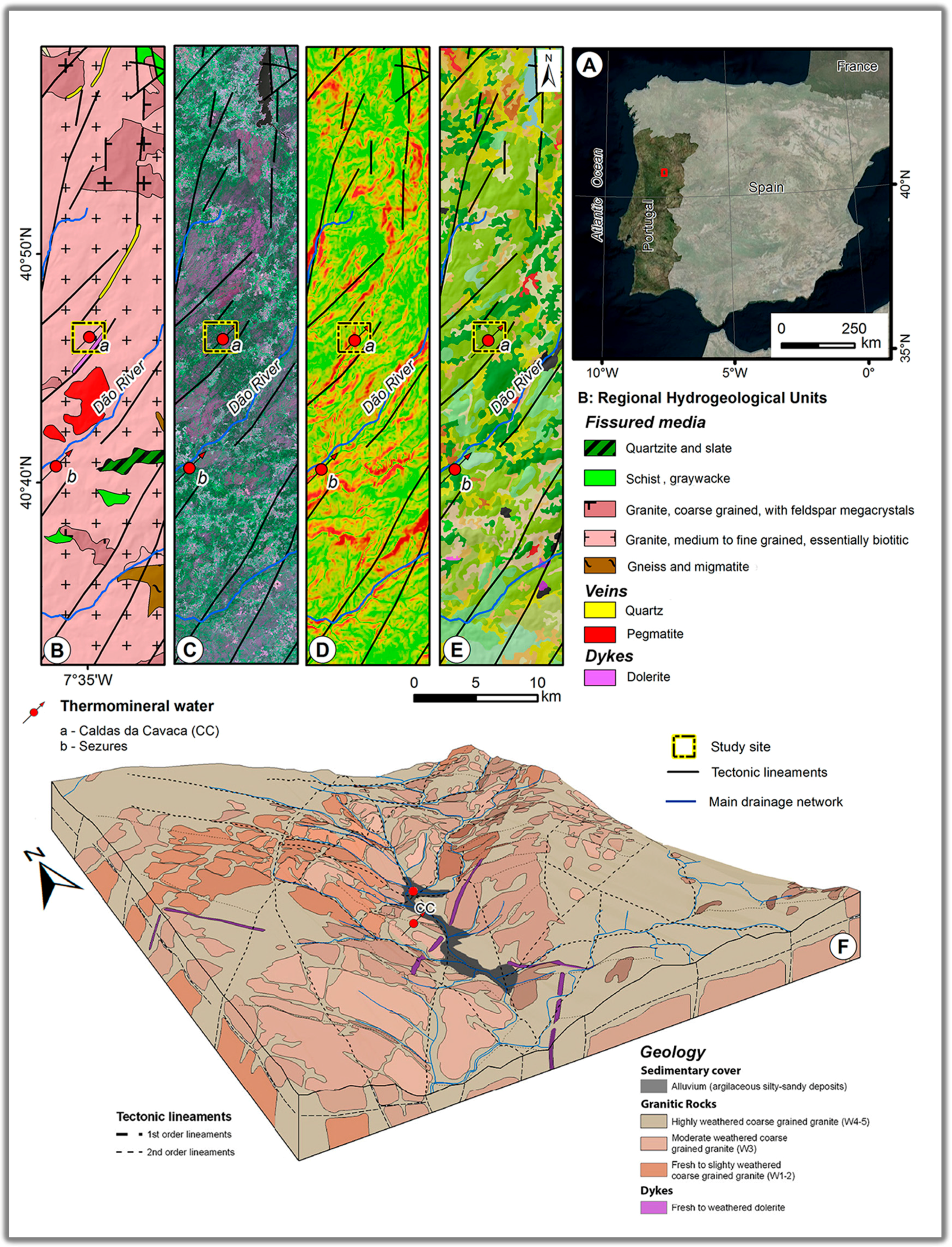
2. Regional Framework: Caldas da Cavaca Hydromineral System
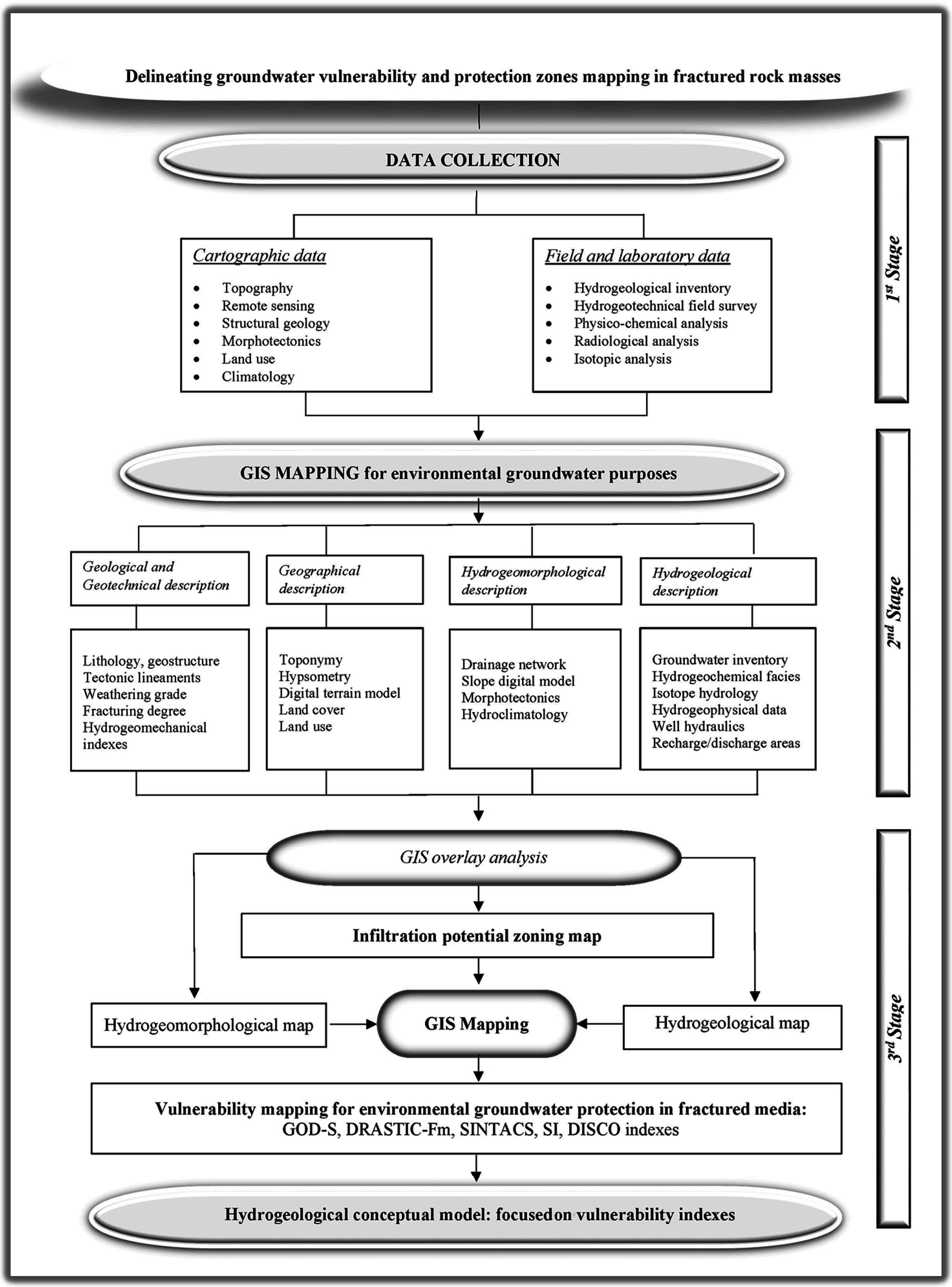
3. Materials and Methods
- GOD-S is an evolution of GOD index, considering soil media properties [10];
- DRASTIC-Fm is a modified version of DRASTIC, taking into consideration the characteristics of fissured hard-rock aquifers. The fractured media parameter (Fm) was derived from the map of tectonic lineaments density, and collected into four classes, with ratings ranging from 4 to 10, depending on the tectonic lineament density [8,26,28,48,50];
- SI, where the Land Use (LU) parameter was derived from land cover maps [32];
4. Results and Discussion
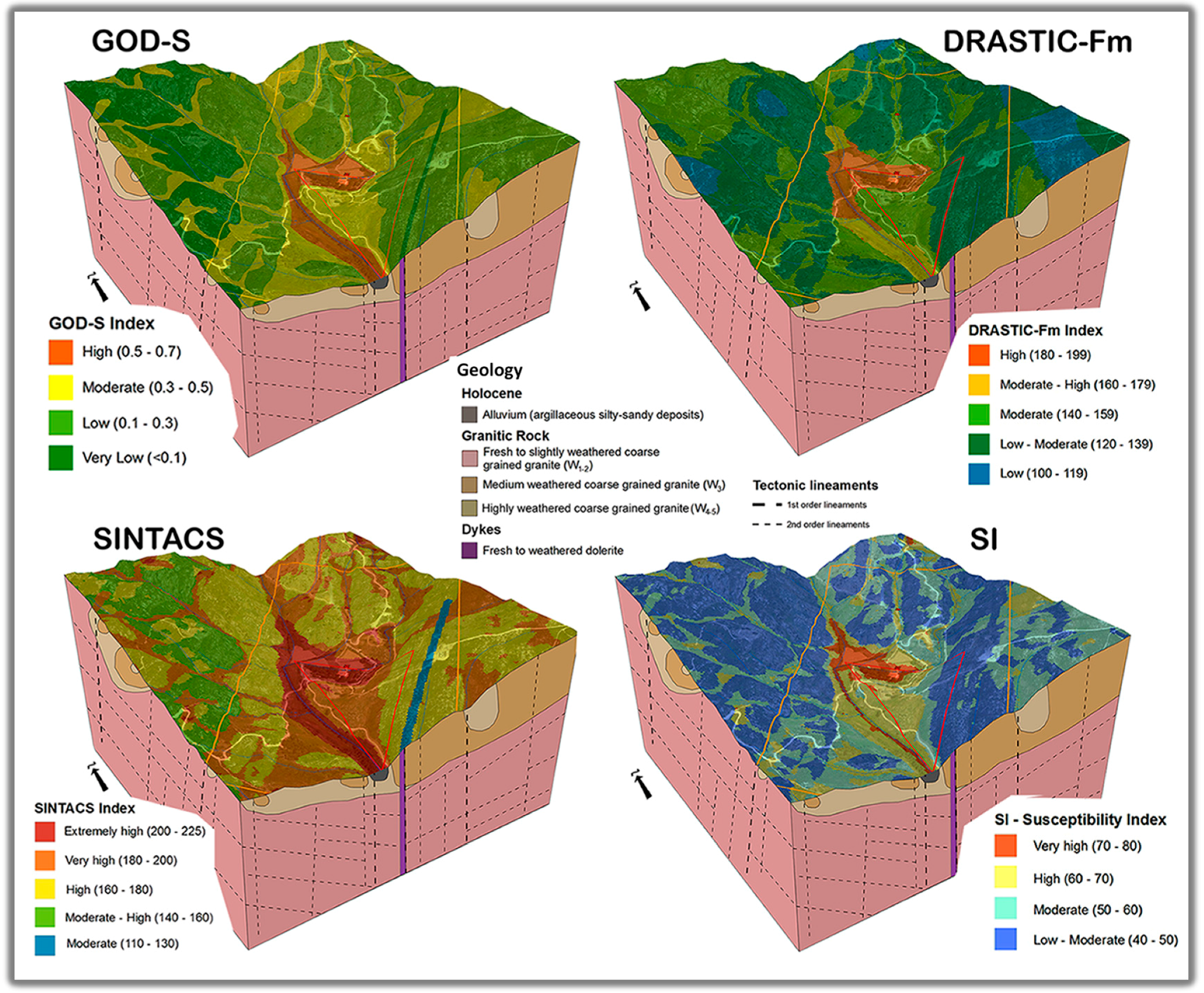
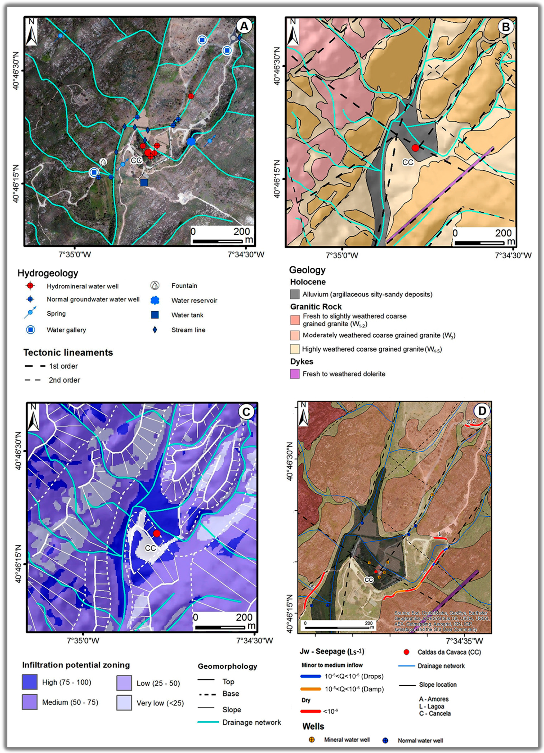
4.1. Local Hydrogeological, Hydrogeomorphological and Hydrogeomechanical Framework
- Fresh to slightly weathered coarse grained granite (W1-2), which dominates in the higher altitudes, around 600–700 m, and shows moderate fracturing degree (F3) with very close to close fracturing degree (F4-5);
- Moderately weathered coarse grained granite (W3), which dominates in the lower altitudes, around 500–650 m, particularly in a wide corridor between 500 and 1000 m length that is compatible with a general NE–SW trend;
- Highly weathered coarse grained granite (W4-5), which basically prevails in plateau regions.
- Type of discontinuities: joints are the dominant discontinuities in the rock mass. They are grouped into two sets of joints: the first set has a direction of N 120°–150° E and dip ranges from 75° to 90° NE/SW; and the second set has a general direction towards N 20°–80° E and dips between 55° SE and 90° SE;
- Weathering grade: In all of the slopes in the area, a moderately weathered rock (W3) prevails and, in addition, a highly weathered rock (W4-5), as well as some fresh to slightly weathered rock (W1-2) on the Amores and Lagoa slopes (Figure 3D);
- Water seepage content: This is related to flow through the rock mass joints. Although the Lagoa slope displayed small sections classified as wet (10–100 drop per minute) or damp (1–10 drop per minute), most of the slope was classified as dry. As for the Amores slope, small sections were classified as damp (1 ≤ drops/min < 10), while the Cancela slope was completely dry;
- Fracturing degree: the parameter trend exhibited higher occurrence of wide spacing discontinuities (F1-2) and discontinuities with moderate spacing (F3), as well as a small percentage of close spacing discontinuities (F4-5).
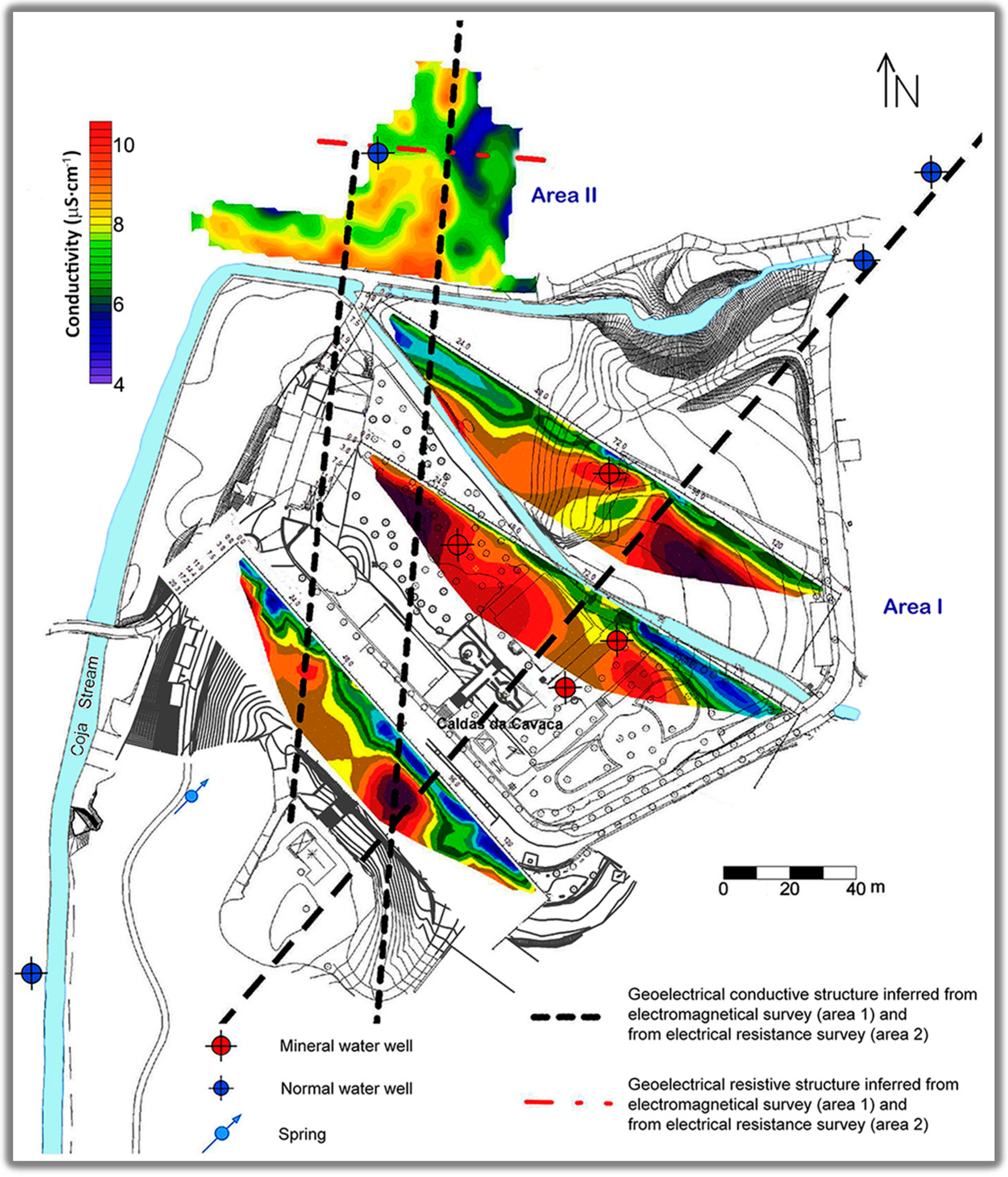
4.2. Geophysical Survey
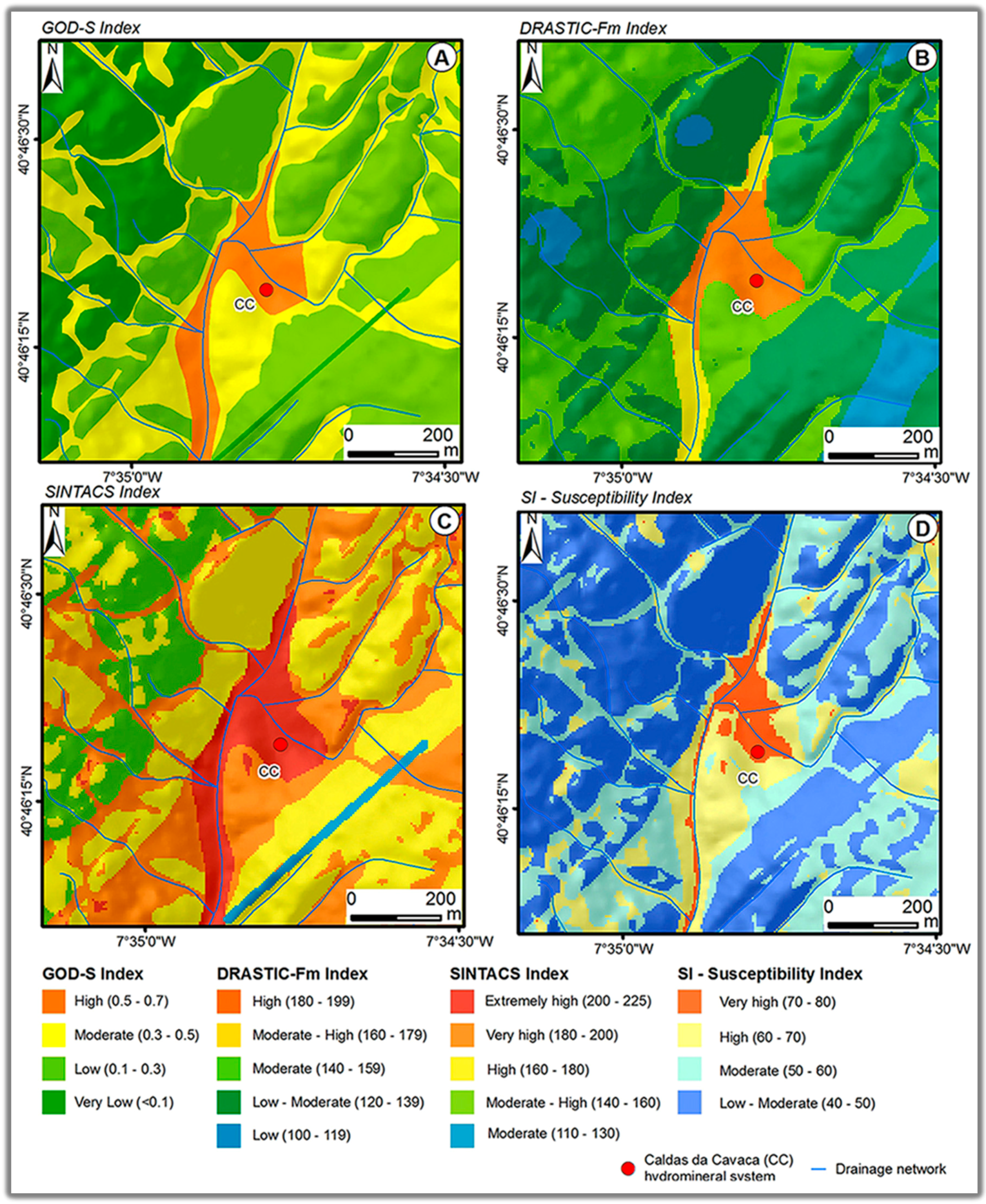
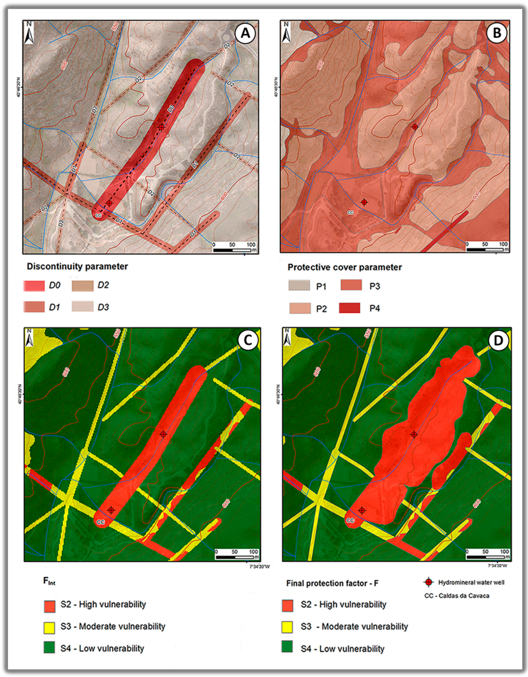
4.3. Multicriteria Intrinsic Vulnerability Assessment
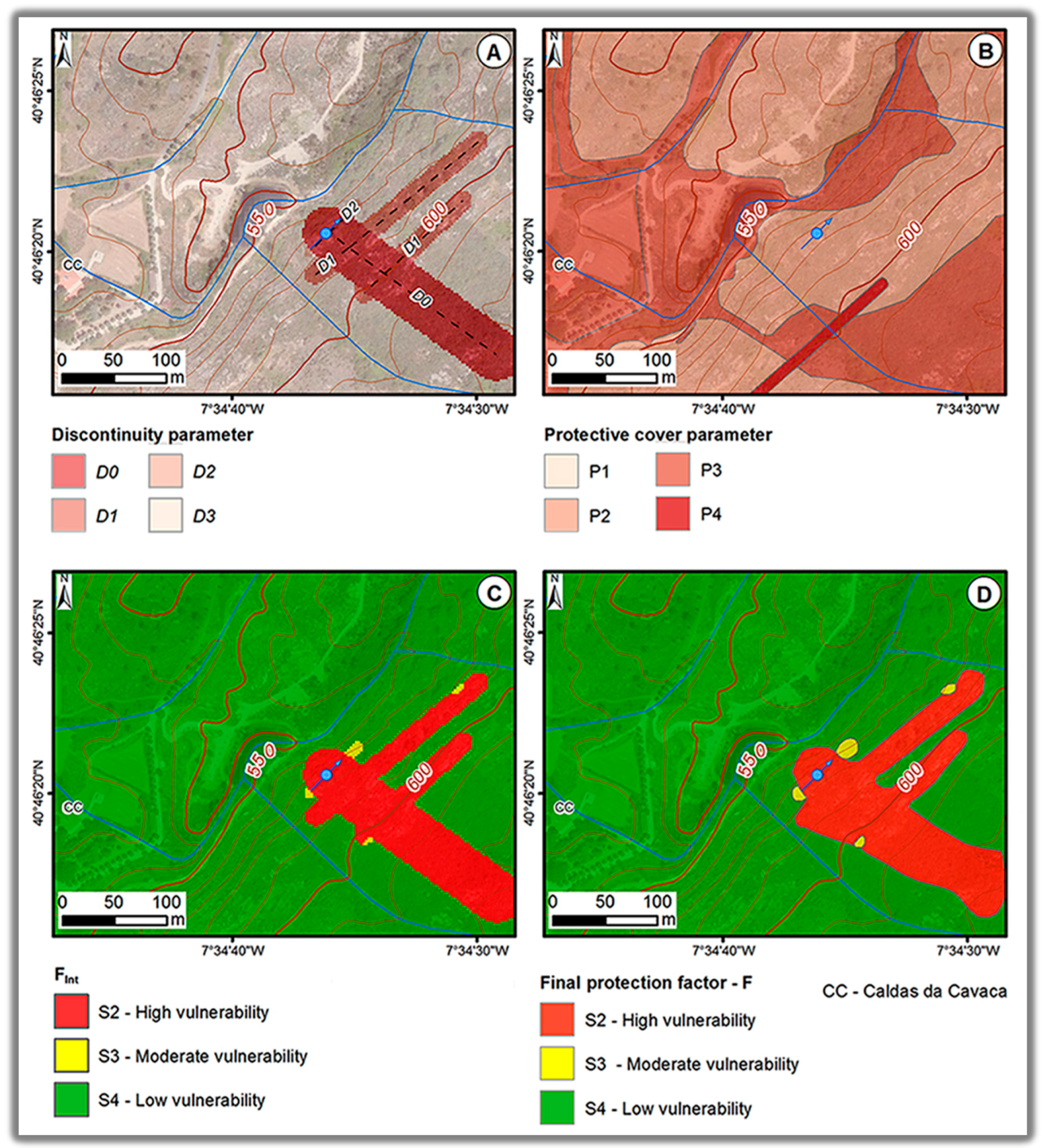
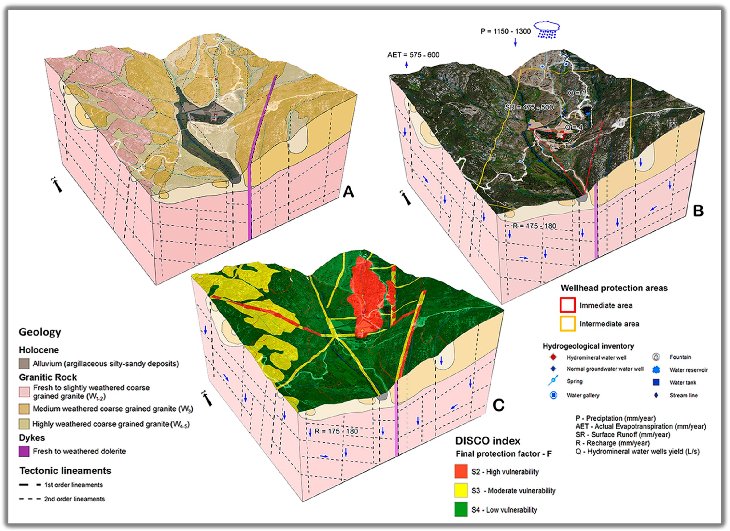
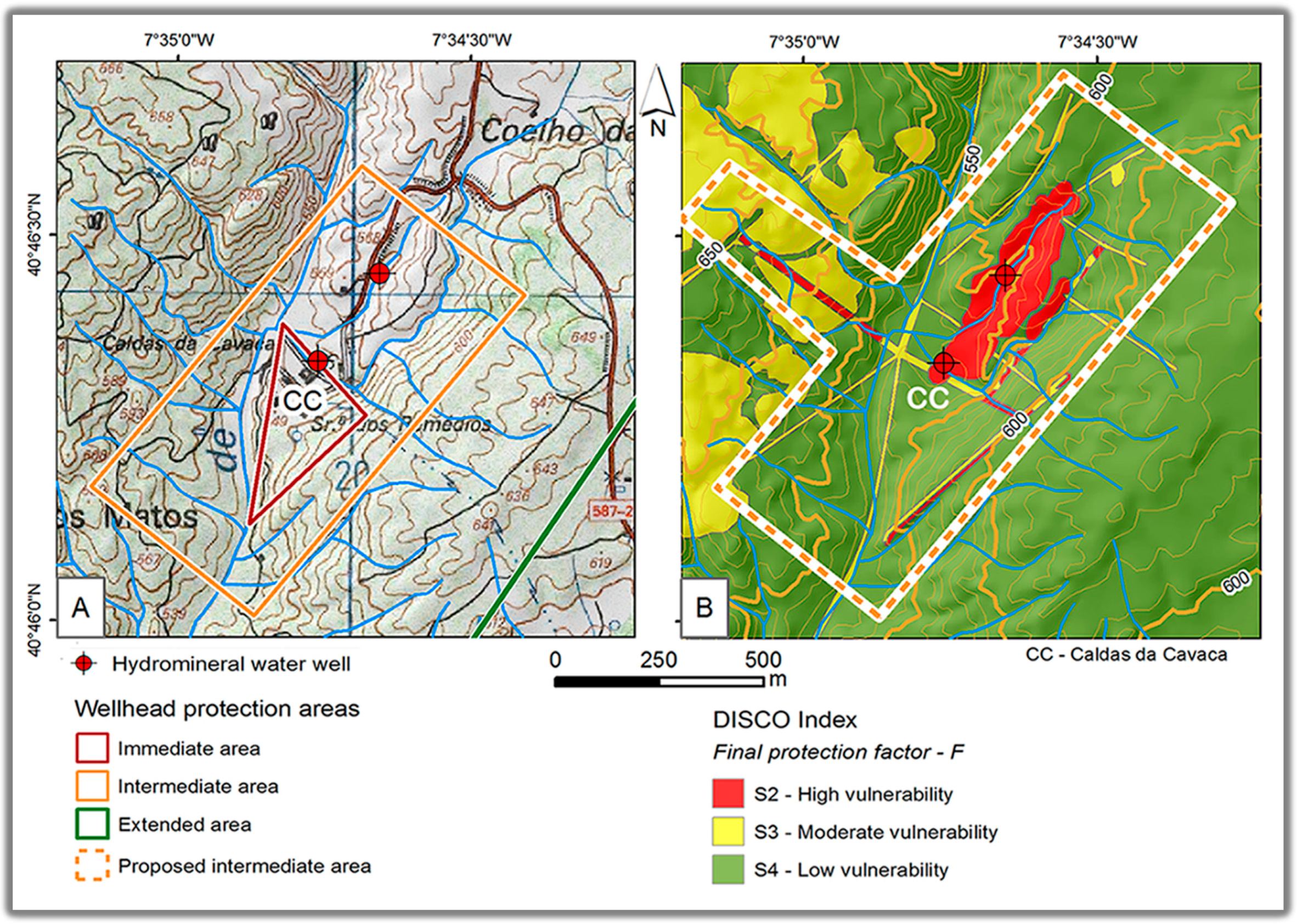
4.4. Wellhead Protection Zones: An Updated Proposal
4.5. Hydrogeology Conceptual Site Model: Inputs from Intrinsic Vulnerability Mapping
- Shallow and unconfined aquifer: this is located in the bottom of the valley, associated with the alluvial deposits. The groundwater (sodium chloride to sodium bicarbonate facies) of this aquifer is characterized by pH of around 5–6.5 and very low mineralization, with electrical conductivity under 20 μS/cm; the temperature of the water is similar to the mean monthly air temperature. The intrinsic vulnerability to contamination of this aquifer varies from high to very high.
- Unconfined to semi-confined aquifer: this is located in the fractured and weathered granitic with transmissivity lower than 1 m2/day and very low water yields (less than 0.05 L·s−1). The groundwater from this aquifer is characterized by a sodium chloride facies, with pH around 5–6.5 and low mineralization, with electrical conductivity between 20 and 50 μS/cm. The vulnerability to contamination is moderate to high.
- Deep confined hydromineral aquifer: this is located in the fresh granite dominated by a deep fault zone with transmissivity ranging from 27 to 136 m2/day. The Ribeira de Coja fault zone is considered the main structure of the hydromineral water reservoir. These waters are characterized by pH of around 8.4–8.6, temperatures around 29 °C and intermediate mineralization with electrical conductivity ranging from 350 to 430 μS/cm. Moreover, the hydromineral waters of this aquifer have an alkaline reaction, are fluoridated and sulfurous, and have sodium bicarbonate hydrogeochemical facies. The intrinsic vulnerability to contamination is high in the discharge area (wellhead site), but very low in the deep hydromineral reservoir.
5. Conclusions
Acknowledgments
Author Contributions
Conflicts of Interest
References
- Richter, H.E.; Gungle, B.; Lacher, L.J.; Turner, D.S.; Bushman, B.M. Development of a shared vision for groundwater management to protect and sustain baseflows of the Upper San Pedro River, Arizona, USA. Water 2014, 6, 2519–2538. [Google Scholar] [CrossRef]
- Committee on Fracture Characterization and Fluid Flow (CFCFF). Rock Fractures and Fluid Flow: Contemporary Understanding and Applications; National Academy of Sciences: Washington, DC, USA, 1996. [Google Scholar]
- Scesi, L.; Gattinoni, P. Water Circulation in Rocks; Springer: Dordrecht, The Netherlands, 2009. [Google Scholar]
- Singhal, B.S.; Gupta, R.P. Applied Hydrogeology of Fractured Rocks, 2nd ed.; Springer: Heidelberg, Germany, 2010. [Google Scholar]
- Gustafson, G. Hydrogeology for Rock Engineers; BeFo and ISRM: Stockholm, Sweden, 2012. [Google Scholar]
- Jaiswal, R.K.; Mukherjee, S.; Krishnamurthy, J.; Saxena, R. Role of remote sensing and GIS techniques for generation of groundwater prospect zones towards rural development—An approach. Int. J. Remote Sens. 2003, 24, 993–1008. [Google Scholar] [CrossRef]
- Albinet, M.; Margat, J. Cartographie de la vulnérabilité à la pollution des nappes d’eau souterraine. Bull. BRGM (Paris) 1970, 2, 13–22. [Google Scholar]
- Aller, L.; Bennet, T.; Lehr, J.H.; Petty, R.J. DRASTIC: A Standardized System for Evaluating Groundwater Pollution Potential Using Hydrologic Settings; Robert, S., Ed.; Technical Report; U.S. EPA Report, 600/2-87/035; Kerr Environmental Research Laboratory: Ada, OK, USA, 1987. [Google Scholar]
- Vrba, J.; Zaporozec, A. Guidebook on Mapping Groundwater Vulnerability; International Contributions to Hydrogeology; Velrag Heinz Heise: Hannover, Germany, 1994; Volume 16. [Google Scholar]
- Foster, S.; Hirata, R.; Gomes, D.; Delia, M.; Paris, M. Groundwater Quality Protection: A Guide for Water Utilities, Municipal Authorities, and Environment Agencies; The International Bank for Reconstruction and Development; The World Bank: Washington, DC, USA, 2002. [Google Scholar]
- Witkowski, A.; Kowalczyk, A.; Vrba, J. (Eds.) Groundwater Vulnerability Assessment and Mapping; Taylor & Francis Group: London, UK, 2007.
- Morris, B.; Lawrence, A.; Chilton, J.; Adams, B.; Klinck, B.; Calow, R. Groundwater and Its Susceptibility to Degradation: A Global Assessment of the Problem and Options for Management; United Nations Environment Programme: Nairobi, Kenya, 2003. [Google Scholar]
- Robins, N.S.; Chilton, P.J.; Cobbing, J.E. Adapting existing experience with aquifer vulnerability and groundwater protection for Africa. J. Afr. Earth Sci. 2007, 47, 30–38. [Google Scholar] [CrossRef]
- Gemitzi, A.; Petalas, C.; Tsihrintzis, V.; Pisinaras, V. Assessment of groundwater vulnerability to pollution: A combination of GIS, fuzzy logic and decision making techniques. Environ. Geol. 2006, 49, 653–673. [Google Scholar] [CrossRef]
- Pisinaras, V.; Polychronis, C.; Gemitzi, A. Intrinsic groundwater vulnerability determination at the aquifer scale: A methodology coupling travel time estimation and rating methods. Environ. Earth Sci. 2016, 75, 85. [Google Scholar] [CrossRef]
- Daly, D.; Warren, W.P. Mapping Groundwater Vulnerability: The Irish Perspective; Geological Survey of Ireland: Dublin, Ireland, 1998. [Google Scholar]
- González, A.; Sánchez, A.L.; Requena, P.M.; Varela, M.S. Assessment of the microbiological quality of groundwater in three regions of the Valencian Community (Spain). Int. J. Environ. Res. Public Health 2014, 11, 5527–5540. [Google Scholar] [CrossRef] [PubMed]
- Jha, M.K.; Chowdhury, A.; Chowdary, V.; Peiffer, S. Groundwater management and development by integrated remote sensing and geographic information systems: Prospects and constraints. Water Resour. Manag. 2007, 21, 427–467. [Google Scholar] [CrossRef]
- Saaty, T.L. Decision making with the analytic hierarchy process. Int. J. Serv. Sci. 2008, 1, 83–98. [Google Scholar] [CrossRef]
- Margat, J.; van der Gun, J. Groundwater around the World: A Geographic Synopsis; Taylor & Francis Group: Boca Raton, FL, USA, 2013. [Google Scholar]
- Chaminé, H.I. Water resources meet sustainability: New trends in environmental hydrogeology and groundwater engineering. Environ. Earth Sci. 2015, 73, 2513–2520. [Google Scholar] [CrossRef]
- Chaminé, H.I.; Carvalho, J.M.; Teixeira, J.; Freitas, L. Role of hydrogeological mapping in groundwater practice: Back to basics. Eur. Geol. J. 2015, 40, 34–42. [Google Scholar]
- Junior, R.F.; Varandas, S.G.P.; Fernandes, L.F.S. Multicriteria analysis for the monitoring of aquifer vulnerability: A scientific tool in environmental policy. Environ. Sci. Policy 2015, 48, 250–264. [Google Scholar] [CrossRef]
- Sahoo, S.; Dhar, A.; Kar, A.; Chakraborty, D. Index-based groundwater vulnerability mapping using quantitative parameters. Environ. Earth Sci. 2016, 75, 522. [Google Scholar] [CrossRef]
- Teixeira, J.; Chaminé, H.I.; Espinha Marques, J.; Gomes, A.; Carvalho, J.M.; Pérez-Alberti, A.; Rocha, F. Integrated approach of hydrogeomorphology and GIS mapping to the evaluation of groundwater resources: An example from the hydromineral system of Caldas da Cavaca, NW Portugal. In Global Groundwater Resources and Management: Selected Papers from the 33rd International Geological Congress; Paliwal, B.S., Ed.; Scientific Publishers: Jodhpur, India, 2010; pp. 227–249. [Google Scholar]
- Teixeira, J.; Chaminé, H.I.; Espinha Marques, J.; Carvalho, J.M.; Pereira, A.J.; Carvalho, M.R.; Fonseca, P.E.; Pérez-Alberti, A.; Rocha, F. A comprehensive analysis of groundwater resources using GIS and multicriteria tools (Caldas da Cavaca, Central Portugal): Environmental issues. Environ. Earth Sci. 2015, 73, 2699–2715. [Google Scholar] [CrossRef]
- Meirinhos, J. Hydrogeomechanics for Rock Engineering: Coupling Subsurface Hydrogeomechanical Assessment and Hydrogeotechnical Mapping on Fractured Rock Masses. Master’s Thesis, School of Engineering, Polytechnic of Porto, Porto, Portugal, 2015. [Google Scholar]
- Denny, S.C.; Allen, D.M.; Journeay, M. DRASTIC-Fm: A modified vulnerability mapping method for structurally-controlled aquifers. Hydrogeol. J. 2007, 15, 483–493. [Google Scholar] [CrossRef]
- Civita, M.V.; de Maio, M. Assessing and mapping aquifer vulnerability to contamination: The Italian “combined” approach. Geofísica Internacional 2000, 43, 513–532. [Google Scholar]
- Civita, M.V. Le Carte Della Vulnerabilità Degli Acquiferi All’inquinamento; Teoria & Practica Pitagora: Bologna, Italy, 2010. [Google Scholar]
- Ribeiro, A.; Munhá, J.; Dias, R.; Mateus, A.; Pereira, E.; Ribeiro, L.; Fonseca, P.E.; Araújo, A.; Oliveira, J.T.; Romão, J.; et al. Geodynamic evolution of the SW Europe Variscides. Tectonics 2007, 26, 1–24. [Google Scholar] [CrossRef]
- Stigter, T.Y.; Ribeiro, L.; Dill, A.M. Evaluation of an intrinsic and a specific vulnerability assessment method in comparison with groundwater salinisation and nitrate contamination levels in two agricultural regions in the south of Portugal. Hydrogeol. J. 2006, 14, 79–99. [Google Scholar] [CrossRef]
- Pochon, A.; Zwahlen, F. Délimitation des Zones de Protection des Eaux Souterraines en Milieu Fissuré; Technical Report; Office Fédéral de L’environnement: Berne, Switzerland, 2003. [Google Scholar]
- Pochon, A.; Tripet, J.-P.; Kozel, R.; Meylan, B.; Sinreich, M.; Zwahlen, F. Groundwater protection in fractured media: A vulnerability-based approach for delineating protection zones in Switzerland. Hydrogeol. J. 2008, 16, 1267–1281. [Google Scholar] [CrossRef]
- Freire Andrade, C. Projecto de Modificação de Captagem das Águas das Caldas da Cavaca; Unpublished Technical Report; Serviços Geológicos: Lisboa, Portugal, 1935; p. 11. [Google Scholar]
- Freire Andrade, C. Os Vales Submarinos Portugueses e o Diastrofismo das Berlengas e da Estremadura; Serviços Geológicos: Lisboa, Portugal, 1937; p. 236. [Google Scholar]
- Freire Andrade, C. Nota Acerca dos Trabalhos Realizados para a Modificação da Captagem das Águas Medicinaes das Caldas da Cavaca; Unpublished Technical Report; Serviços Geológicos: Lisboa, Portugal, 1938; p. 7. [Google Scholar]
- Acciaiuoli, L. Le Portugal Hydromineral; Direcção Geral, Serviços Geológicos: Lisbonne, Portugal, 1952; Volume 2. [Google Scholar]
- Boorder, H. Petrological Investigations in the Aguiar da Beira Granite Area, Northern Portugal. Ph.D. Thesis, University of Amsterdam, Amsterdam, The Netherlands, 1965. [Google Scholar]
- Teixeira, J. Hidrogeomorfologia e Sustentabilidade de Recursos Hídricos Subterrâneos. Ph.D. Thesis, University of Aveiro, Aveiro, Portugal, 2011. [Google Scholar]
- Carvalho, J.M. Prospecção e Pesquisa de Recursos Hídricos Subterrâneos no Maciço Antigo Português: Linhas Metodológicas. Ph.D. Thesis, University of Aveiro, Aveiro, Portugal, 2006. [Google Scholar]
- Peel, M.C.; Finlayson, B.L.; McMahon, T.A. Updated world map of the Köppen-Geiger climate classification. Hydrol. Earth Syst. Sci. 2007, 11, 1633–1644. [Google Scholar] [CrossRef]
- Brum Ferreira, A. Neotectonics in Northern Portugal: A geomorphological approach. Z. Geomorphol. 1991, 82, 73–85. [Google Scholar]
- Carvalho, J.M.; Chaminé, H.I.; Afonso, M.J.; Espinha Marques, J.; Teixeira, J.; Cerqueira, A.; Coelho, A.; Gomes, A.; Fonseca, P.E. Prospecção hidrogeológica da área do sistema hidromineral das Caldas da Cavaca (Aguiar da Beira, Portugal Central): Implicações na gestão dos recursos hídricos subterrâneos. In Actas del I Foro Ibérico Sobre Aguas Envasadas y Balnearios; Fernández Rubio, R., Ed.; Asociación Nacional de Empresas de Aguas de Bebida Envasadas: Madrid, Portugal, 2005; pp. 109–121. [Google Scholar]
- Espinha Marques, J. Revisão do Plano de Exploração da Concessão Hidromineral HM-11 Caldas da Cavaca (Dezembro); Unpublished Technical Report; Faculdade de Ciências da Universidade do Porto: Porto, Portugal, 2008; p. 24. [Google Scholar]
- Espinha Marques, J. Revisão do Plano de Exploração da Concessão Hidromineral HM-11 Caldas da Cavaca (Maio); Unpublished Technical Report; Faculdade de Ciências da Universidade do Porto: Porto, Portugal, 2008; p. 61. [Google Scholar]
- Chaminé, H.I.; Carvalho, J.M.; Afonso, M.J.; Teixeira, J.; Freitas, L. On a dialogue between hard-rock aquifer mapping and hydrogeological conceptual models: Insights into groundwater exploration. Eur. Geol. J. 2013, 35, 26–31. [Google Scholar]
- Teixeira, J.; Chaminé, H.I.; Carvalho, J.M.; Pérez-Alberti, A.; Rocha, F. Hydrogeomorphological mapping as a tool in groundwater exploration. J. Maps 2013, 9, 263–273. [Google Scholar] [CrossRef]
- Saaty, T.L. A scaling method for priorities in hierarchical structures. J. Math. Psychol. 1977, 15, 234–281. [Google Scholar] [CrossRef]
- Narany, T.S.; Ramli, M.F.; Aris, A.Z.; Sulaiman, W.N.; Fakharian, K. Spatial assessment of groundwater quality monitoring wells using indicator kriging and risk mapping, Amol-Babol Plain, Iran. Water 2014, 6, 68–85. [Google Scholar] [CrossRef]
- Terra, Ambiente & Recursos Hídricos Lda. Estudo Hidrogeológico da Concessão Hidromineral HM-11 Caldas da Cavaca e Terrenos Envolventes; Unpublished Technical Report; TARH—Terra, Ambiente & Recursos Hídricos Lda.: Sacavém, Portugal, 2005; p. 42. [Google Scholar]
- GeoSonda Lda. Prospecção Electromagnética nas Caldas da Cavaca; Unpublished Technical Report; GeoSonda Lda.: Santa Maria da Feira, Portugal, 2004; p. 7. [Google Scholar]
- Meerkhan, H. Delineating Environmental Groundwater Vulnerability and Protection Zones Mapping in Fractured Rock Masses. Master’s Thesis, School of Engineering, Polytechnic of Porto, Porto, Portugal, 2015. [Google Scholar]


| Hydrogeological Units | |||||
|---|---|---|---|---|---|
| Sands and Gravels | Highly Weathered Coarse Grained Granite (W4-5) | Moderately Weathered Coarse Grained Granite (W3) | Fresh to Slightly Weathered Coarse Grained Granite (W1-2) | Fresh to Weathered Dolerite Dyke (W1-2 to W4-5) | |
| G | unconfined | confined/semi-confined | confined/semi-confined | confined/semi-confined | confined |
| O | alluvial sands/gravels | igneous formations | igneous formations | igneous formations | igneous formations |
| D | <5 | 5–20 | 5–20 | <5 | 5–20 |
| |S | silty-sand | silty-clay | silt | thin/absent | silty-clay |
| D | 1.5–4.6 | 4.5–9 | 4.5–9 | 1.5–4.6 | 4.6–9.1 |
| R | 250 | 175 | 175 | 175 | 175 |
| A | sand and gravel | igneous/weathered igneous | igneous/weathered igneous | igneous | igneous/weathered igneous |
| S | sandy loam | clay loam | silty-loam | sandy loam | clay loam |
| T | 0%–60% | 0%–60% | 0%–60% | 0%–60% | 0%–60% |
| I | sand and gravel with significant clay | sand and gravel with significant clay | igneous | igneous | igneous |
| C | <4.1 m/day | <4.1 m/day | <4.1 m/day | <4.1 m/day | <4.1 m/day |
| Fm | 0–25 km of lineament/km2 | 0–25 km of lineament/km2 | 0–5 km of lineament/km2 | 0–25 km of lineament/km2 | 0–25 km of lineament/km2 |
| S | 1.5–4.6 | 4.5–9 | 4.5–9 | 1.5–4.6 | 4.6–9.1 |
| I | 250 | 175 | 175 | 175 | 175 |
| N | coarse alluvial deposit | fissured plutonic rock | fissured plutonic rock | fissured plutonic rock | fissured plutonic rock |
| T | sandy-loam | clay-loam | silty-loam | sandy-loam | clay-loam |
| A | coarse alluvial deposit | fissured plutonic rock | fissured plutonic rock | Fissured plutonic rock | fissured plutonic rock |
| C | 5 × 10⁻⁵–1 × 10⁻⁴ | <5 × 10⁻⁵ | <5 × 10⁻⁵ | <5 × 10⁻⁵ | <5 × 10⁻⁵ |
| S | The rating for this parameter is variable since slope values are calculated for each pixel of the ArcGIS raster dataset | ||||
| D | 1.5–4.6 | 4.5–9 | 4.5–9 | 1.5–4.6 | 4.6–9.1 |
| R | 250 | 175 | 175 | 175 | 175 |
| A | sand and gravel | igneous/weathered igneous | igneous/weathered igneous | igneous | igneous/weathered igneous |
| T | The rating for this parameter is variable since slope values are calculated for each pixel of the ArcGIS raster dataset | ||||
| LU | The rating for this parameter is variable since land use is calculated for each pixel of the ArcGIS raster dataset | ||||
| Hydrogeological Units | ||||||
|---|---|---|---|---|---|---|
| Alluvia (Silty-Sandy Deposits) | Highly Weathered Coarse Grained Granite () | Moderately Weathered Coarse Grained Granite () | Fresh to Slightly Weathered Coarse Grained Granite () | Fresh to Weathered Dolerite Dyke (W1-2 to W4-5) | ||
| Protective cover (CO): pedological soil | Description | High permeability soil (sand, pebbles) | Moderate permeability soil (silt, loam) | Moderate permeability soil (silt, loam) | Moderate permeability soil (silt, loam) | Low permeability soil (loam, clay) |
| Thickness (m) | >5 | >1 | 0.2–0.5 | 0–0.2 | >1 | |
| Class | ||||||
| Protective cover (CO): geological formations | Description | Combined with soil | Combined with soil | Combined with soil | Combined with soil | Combined with soil |
| Thickness (m) | >2 | >2 | 1–2 | <1 | >2 | |
| Class | ||||||
| Rating | 3 | 3 | 2 | 1 | 4 | |
© 2016 by the authors; licensee MDPI, Basel, Switzerland. This article is an open access article distributed under the terms and conditions of the Creative Commons Attribution (CC-BY) license (http://creativecommons.org/licenses/by/4.0/).
Share and Cite
Meerkhan, H.; Teixeira, J.; Espinha Marques, J.; Afonso, M.J.; Chaminé, H.I. Delineating Groundwater Vulnerability and Protection Zone Mapping in Fractured Rock Masses: Focus on the DISCO Index. Water 2016, 8, 462. https://doi.org/10.3390/w8100462
Meerkhan H, Teixeira J, Espinha Marques J, Afonso MJ, Chaminé HI. Delineating Groundwater Vulnerability and Protection Zone Mapping in Fractured Rock Masses: Focus on the DISCO Index. Water. 2016; 8(10):462. https://doi.org/10.3390/w8100462
Chicago/Turabian StyleMeerkhan, Helen, José Teixeira, Jorge Espinha Marques, Maria José Afonso, and Helder I. Chaminé. 2016. "Delineating Groundwater Vulnerability and Protection Zone Mapping in Fractured Rock Masses: Focus on the DISCO Index" Water 8, no. 10: 462. https://doi.org/10.3390/w8100462
APA StyleMeerkhan, H., Teixeira, J., Espinha Marques, J., Afonso, M. J., & Chaminé, H. I. (2016). Delineating Groundwater Vulnerability and Protection Zone Mapping in Fractured Rock Masses: Focus on the DISCO Index. Water, 8(10), 462. https://doi.org/10.3390/w8100462