1. Introduction
Global climate change caused by human activities and natural factors has a profound impact on water resources. Water scarcity has threatened sustainable development around the world, and water resource prediction and management have become a key issue [
1,
2]. In inland river basins in cold and arid regions of Northwest China, runoff mainly comes from the upper reaches, and is important for sustainable development of midstream and downstream regions. The runoff simulation in upper reaches is fundamental for the prediction and management of basin water resources [
3,
4]. However, due to the special climate, complex terrains, and lack of technical and financial support in this area, traditional meteorological observation stations are scarce and unevenly distributed. Using the existing meteorological observation stations to drive hydrological model simulates hydrological process, with the data discretisation scheme from point to surface, is limited by location, distribution, and data precision of meteorological observation stations. It is difficult to represent spatial heterogeneity of regional weather conditions, resulting in runoff simulation that deviates greatly from the actual runoff, and has high uncertainty [
5]. Alternatively, regional climate models (RCMs), which can provide a variety of distributed meteorological data with high temporal and spatial resolution, can compensate for the scarcity and uneven distribution of meteorological observation stations and become an effective solution for hydrological model application and prediction and management studies of water resources [
6].
The development of a coupled climate–hydrological model is important to improve hydrological simulation accuracy [
7], and to further study water resource responses to human activities and global climate change [
8,
9,
10]. Lakhatkia et al. [
11] used mesoscale model 5 to simulate the basin hydrological processes and to further study water resource responses to climate scenarios. Evans et al. [
12] compared four RCMs coupled with a same hydrological model used in the Central United States. Christensen and Lettenmaier [
13] used general circulation and variable infiltration capacity models to estimate influences of global climate change on the hydrological processes in Colorado River Basin. Climate and hydrological models have been used increasingly to study the eco-environment in Heihe River Basin (HRB), where the eco-environmental problems are typical in China’s inland river basins [
14,
15,
16,
17,
18,
19]. In such studies, large- or meso-scale climate models, which have high temporal resolution but low spatial resolution, provide climate forcing for the hydrological model, and the simulation accuracy is too poor to meet the requirements of hydrological analysis [
20,
21], and for a smaller basin such as Heihe River Basin (HRB), topographic features have not been considered, and hydrological simulation only focused on model modification.
Due to the wide and increasing use for prediction and management of water resources in cold and arid regions of Northwest China [
22,
23,
24,
25,
26], the soil and water assessment tool (SWAT), a physically-based, semi-distributed hydrological model, is selected to simulate the runoff in the region. The model performance mostly relies on the quality of large quantities of regional weather input parameters with high spatial and temporal resolutions [
27,
28,
29,
30], and these weather input parameters required in SWAT are supplied by regional integrated environmental model system (RIEMS), which takes the effects of regional terrain, soil and vegetation into account and has good applicability for East Asia and large-scale rivers in China [
31,
32,
33].
In this study, RIEMS and SWAT are integrated to a coupled climate–hydrological RIEMS–SWAT model, which focuses on both high-resolution RCM recalibration with observed data, and optimisation of weather input parameters for the coupled climate–hydrological model. The model was applied to simulate monthly runoff from 1995 to 2010 in the upper reaches of HRB. First, RIEMS was recalibrated with observed data; second, abundant and evenly distributed virtual weather stations based on RIEMS were built and provided input parameters for the SWAT model. Then, watershed delineation, sensitivity analysis, and model calibration was conducted in sequence. Simulation results were compared against the observed values to evaluate the applicability of the coupled model.
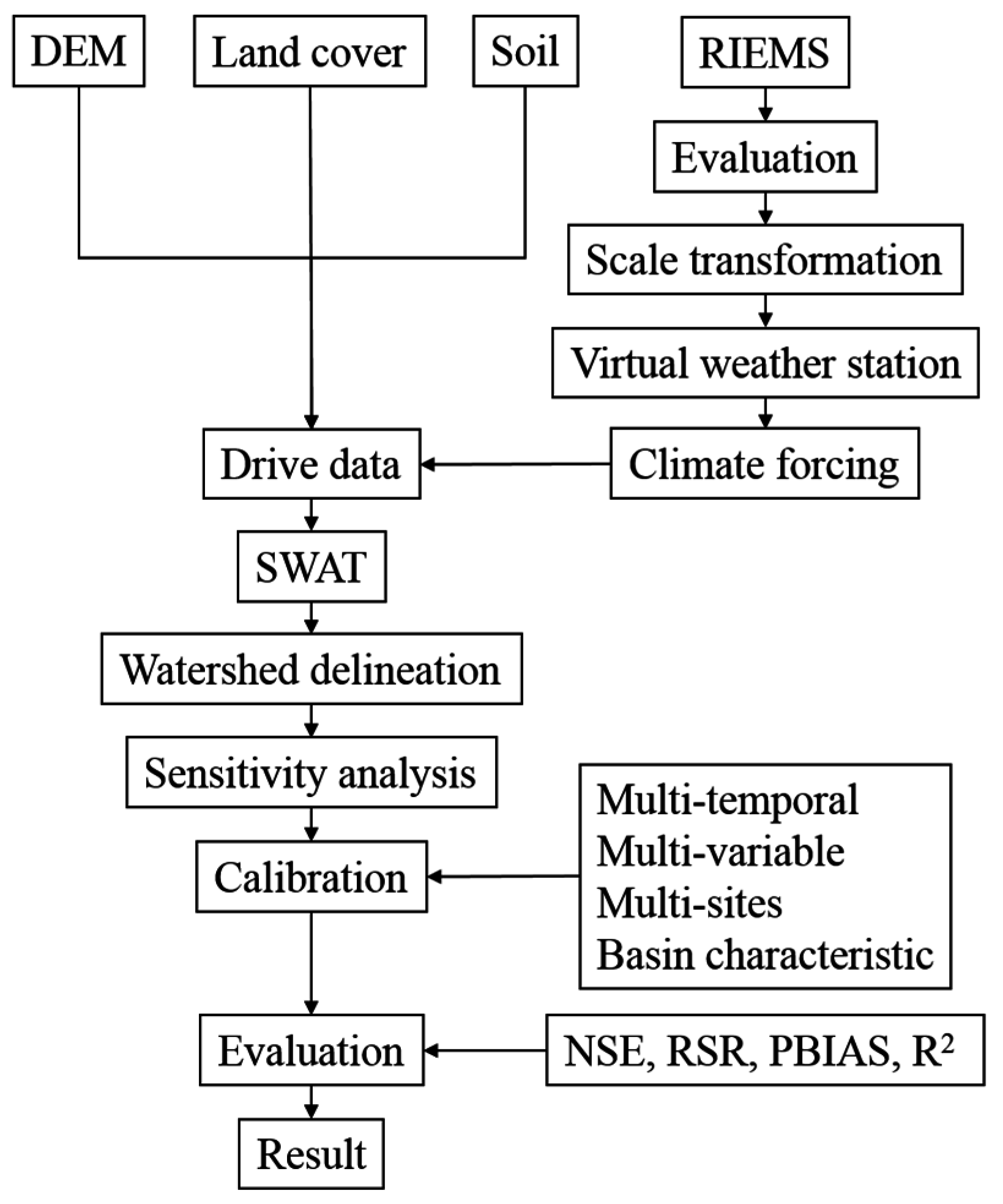
3. Methods
RIEMS evaluation and SWAT simulation were conducted in this study. First, we performed RIEMS evaluation, which is a precondition step of the coupled climate–hydrological model. Second, weather input parameters were prepared by scale transformation and climate parameter calculation and virtual weather stations, which served as climate forcing input parameters for SWAT, were used based on RIEMS; Next, coupling model simulation could be done accordingly. Further, a comprehensive hydrological calibration of SWAT had been selected. Finally, simulation results were evaluated according to certain criteria.
Figure 3 shows a flowchart describing the model coupling method.
3.1. SWAT Hydrological Model
SWAT model is a physically based, semi-distributed hydrological model developed by United States Department of Agriculture. The model is used to simulate watershed movement in water, sediments, nutrients, etc. [
37]. Two parts were included in the SWAT hydrological simulation. The first part consists of land areas that control water transported to channels together with other bodies of water, sediments, nutrients, and so on. The second part includes movements of water and sediment through stream networks to watershed outlets [
38]. A watershed is divided into multiple subwatersheds that are further divided into hydrologic response units (HRUs). HRUs are basic elements for hydrological calculation, which integrate land areas with unique land cover, soil type, and slope combinations. Calculation of HRU hydrological balance is based on precipitation, evapotranspiration, surface runoff, groundwater flow, and so on. The hydrological cycle is simulated by SWAT based on water balance equation, which is as follows:
where
SWt,i is final soil water content (mm H
2O),
SW0,i is initial soil water content on day
i (mm H
2O),
t is time (days),
Qday,i is precipitation amount of precipitation on day
i (mm H
2O),
Qsurf,i is surface runoff amount on day
i (mm H
2O),
Ea,i is amount of evapotranspiration on day
i (mm H
2O),
Wseep,i is amount of water that enters vadose zone from soil profile on day
i (mm H
2O), and
Qgw,i is return flow amount on day
i (mm H
2O).
3.2. RIEMS RCM
RIEMS RCM was designed and developed by START TEA-COM RRC and Department of Atmospheric Science of Nanjing University. RIEMS, which is a grid-based, terrain-following model, can be used to describe regional characteristics of East Asia [
39]. RIEMS includes dynamical component of mesoscale model 5 [
40], biosphere-atmosphere transfer scheme for land surface process representation, cumulus parameterisation [
41,
42,
43], and modified radiation package of community climate model 3 [
44].
HRB-observed datasets and remote sensing data were used to recalibrate RIEMS parameters, which include topography elevation, land cover type, saturated soil water potential, saturated soil hydraulic conductivity, field moisture capacity, wilting point moisture, soil porosity, and parameter
b of soil hydraulic conductivity [
45]. The high-resolution topographic dataset, vegetation classification data and land surface process parameters provided by United States Geological Survey (USGS) and Cold and Arid Regions Science Data Centre at Lanzhou, China. A high-resolution RCM was built for HRB with spatial and temporal resolutions of 3 km × 3 km and 6 h, respectively. This high-resolution RCM based on RIEMS was used to compensate for the deficiency of meteorological observation dataset and to drive the ecological–hydrological model in HRB.
3.3. Coupling Method
The purpose of the coupling method is to capture spatial heterogeneity of regional weather conditions in detail. One-way coupling is the climate model used as a forcing function to drive the hydrological model [
46,
47]. In this study, we proposed a one-way coupling method by building abundant and evenly distributed virtual weather stations based on RIEMS. SWAT was directly coupled with RIEMS by using virtual weather stations data that served as SWAT input parameters. Then, climate model evaluation and climate-forcing data processing were conducted to drive the SWAT model simulation of the runoff process.
3.4. Scale Transformation
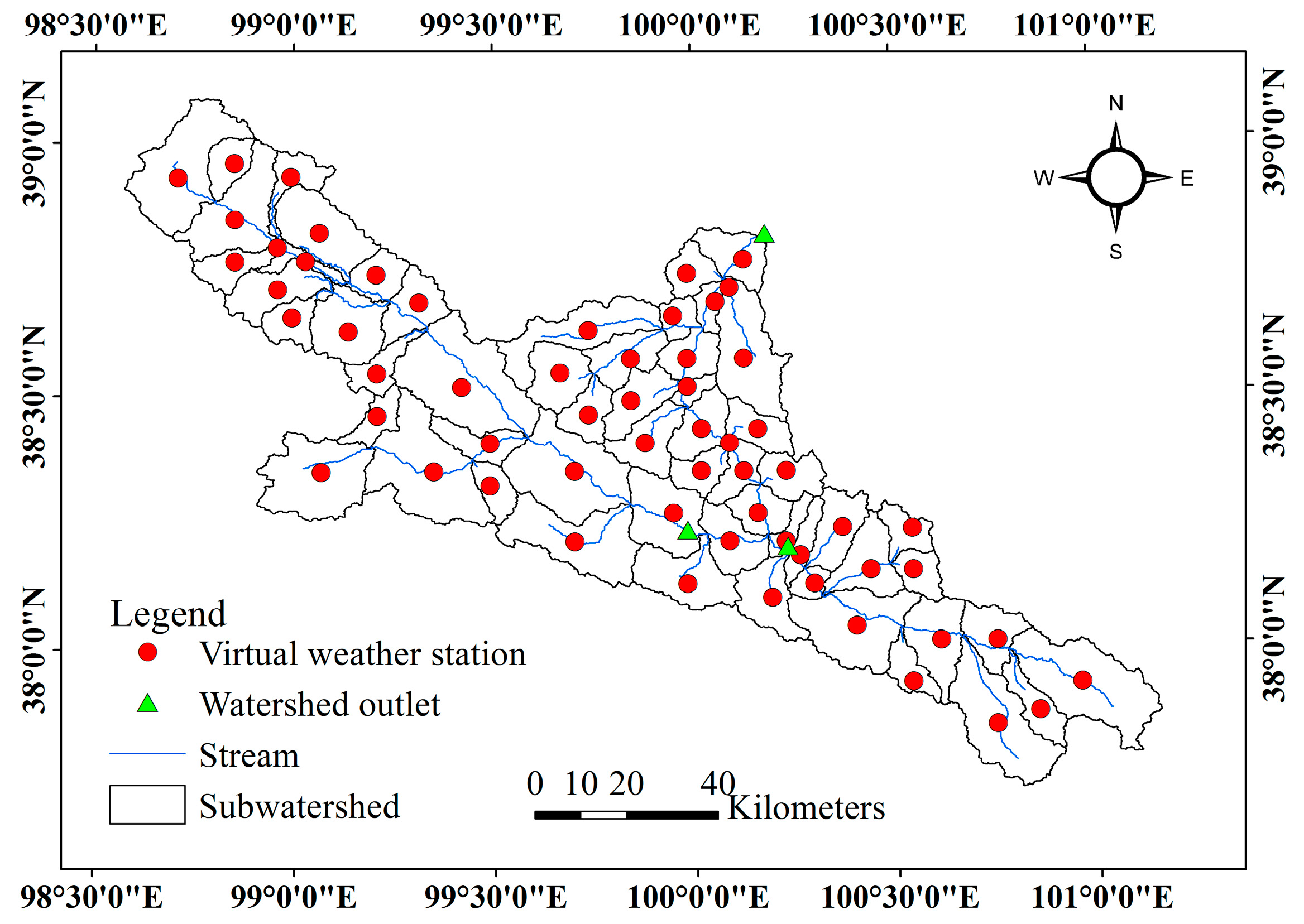
Scale transformation was conducted to match the climate-forcing data with the SWAT format. Scale transformation includes temporal and spatial scale transformations. In temporal scale transformation, the SWAT model needs daily climate data; we used a cumulative summation method to convert 6 h interval climate model data into 24 h interval. In terms of spatial scale transformation, the SWAT model generates many subwatersheds after watershed delineation, each subwatersheds reads the data of the station which is closest to its centre. Then, 3 km × 3 km grid climate model data were converted into 3 km × 3 km point datasets, and the virtual weather stations were built according to the location of subwatersheds and the number of subwatersheds.
3.5. Calibration and Validation
In this study, January 1995 to December 1998 were taken as warm-up periods. Periods from January 1998 to December 2004 and January 2005 to December 2010 were taken as calibration and validation periods, respectively. Calibration is the most important steps in model setup. According to natural basin characteristics, a data-deficient basin should be calibrated to the model with principles of multi-temporal, multi-variable, and multi-site calibration, which can improve the runoff simulation [
5] Multi-temporal calibration for hydrological process was first conducted to average annual values, and then shifted to monthly average annual values. Multi-variable calibration for calibrated model parameters includes surface runoff, lateral flow, underground water, and evaporation simulation values. Calibration simulation values that are only based on observed data are avoided, and the hydrological process can be described properly. Multi-site calibration using the hydrological data of multiple sites on spacing started from the upstream to the downstream, and it did not change the calibrated parameters in the upstream catchment site. Calibration based on natural basin characteristics should be further developed to help calibrate the model better.
3.6. Statistical Evaluation Criteria
Model performances were evaluated with four different measures, which include Nash–Sutcliffe efficiency (NSE), root-mean-square-error-observation standard deviation ratio (RSR), percent bias (PBIAS), and determination coefficient (
R2) [
48,
49,
50,
51]. These criteria are widely used in hydrological model studies [
52,
53]. Calculation processes are as follows:
where
is simulated streamflow, and
is observed streamflow at time step
i; whereas
and
are average observed and simulated streamflow values, respectively, in time periods 1, 2, …, n.
For NSE, average observation data are used to measure the representation of simulation values. The NSE range is from −∞ to 1, and its optimal value is 1 [
48]. For RSR, measured values are used to standardise RMSE and integrate the advantages of error statistics. RSR ranges from 0 to 1. PBIAS measures the average tendency of simulated values. Positive values show overestimation and negative values indicate underestimation; the optimal value is 0 [
50].
R2 ranges from 0 to 1; it represents the proportion of total variance in observation values. Simulation results with higher
R2 show better model performance [
36]. Monthly runoff evaluation standards are summarised in
Table 3 [
48].
5. Discussion
Most of the previous studies used large- or meso-scale climate models that served as input parameters for the hydrological model [
11,
12,
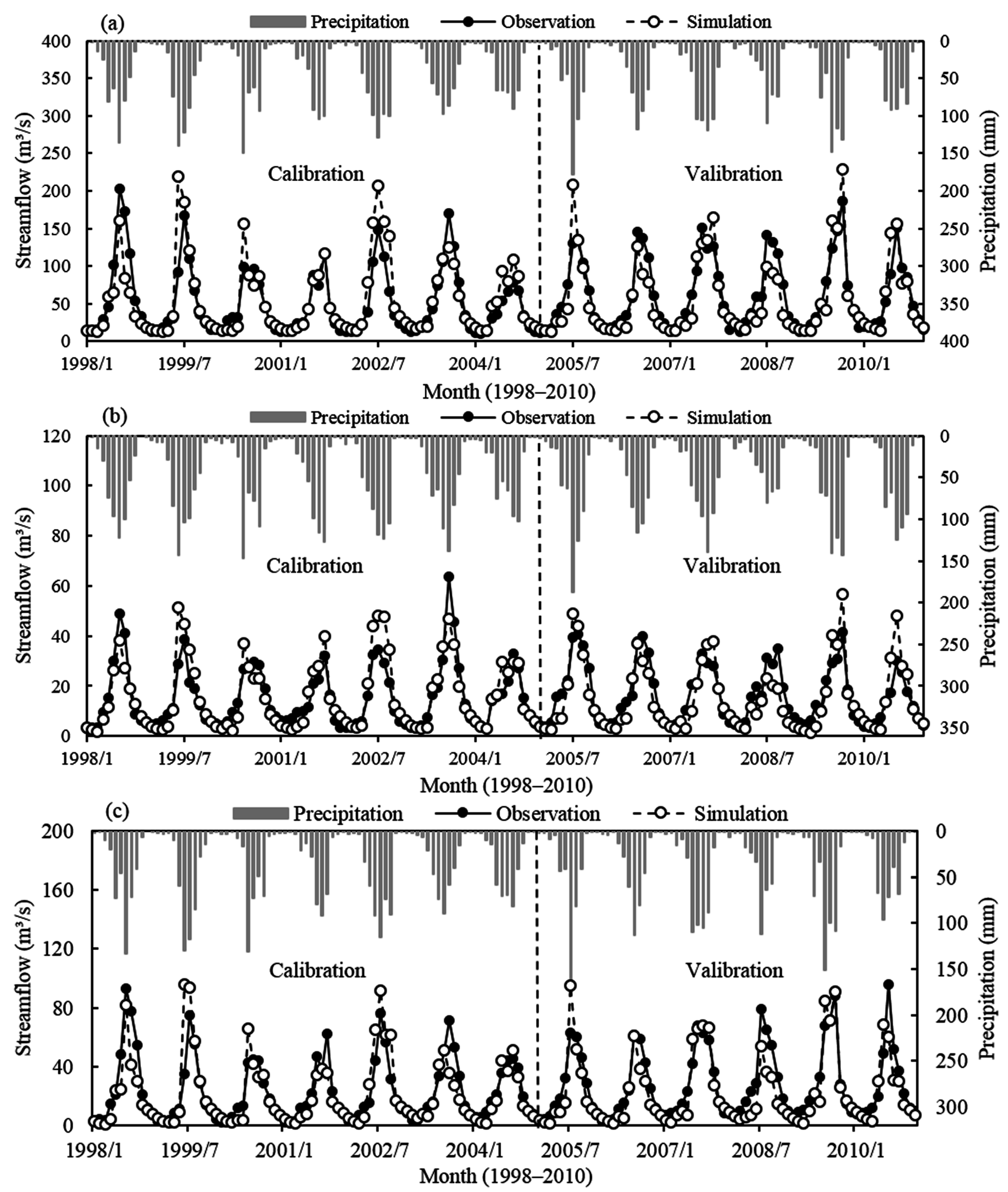
13]. Distributed hydrological simulations require a mass of high spatial and temporal resolutions of weather input parameters, which causes difficulty in meeting the requirements of hydrological simulation because of their coarse spatial resolution. The upper reaches of HRB only have six unevenly distributed meteorological observation stations. In this study, we used a high-resolution RCM based on RIEMS, with spatial and temporal resolutions reaching 3 km × 3 km and 6 h, respectively. RIEMS and SWAT were coupled by building abundant and evenly distributed virtual weather stations. Hydrological simulation achieved a good result, thereby indicating that RIEMS–SWAT coupling has optimised weather input data for hydrological simulation. In addition, the coupling model can provide scientific support for prediction and management of basin water resources.
According to previous studies, hydrological simulation application in the upper reaches of HRB has achieved satisfactory results [
3,
5,
19,
20,
21]. However, this study has certain limitations compared with previous studies. The coupling model exhibits good performance during the drought season, but runoff simulation had a certain bias during the wet season, especially in some years when the peak value had been overestimated (
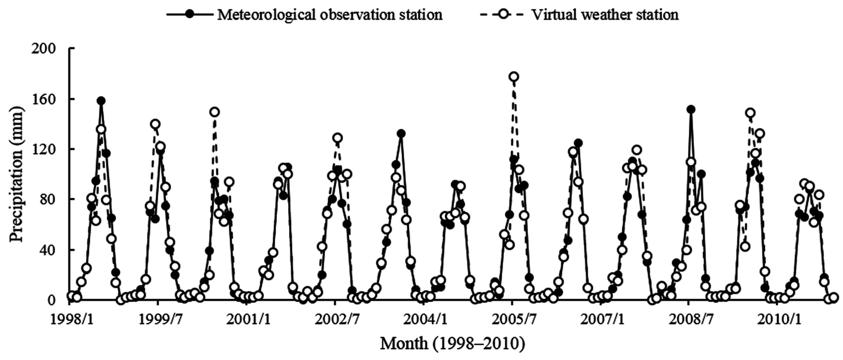
Figure 6). We used virtual weather stations and meteorological observation stations that serve as input parameters for SWAT, and the SWAT model exports two results of basin monthly average precipitation (
Figure 7). Precipitation of the meteorological observation station is close to that of the virtual weather station. However, during wet seasons in 1999, 2002, 2005, and 2009, virtual weather station precipitation was apparently higher than those of meteorological observation stations. Compared with previous findings on watershed characteristics of precipitation, precipitation was overestimated by RIEMS in these periods [
1,
36], which was mostly consistent with the runoff simulation performance and RIEMS evaluation results. It is worth noting that specific humidity cannot be directly used by the SWAT model, we used an empirical formula to calculate relative humidity from specific humidity. To some extent, it has formed the error transfer and influenced the final simulation results.
Further research on enhancing simulation capability of coupled climate–hydrological model is needed. Weather input parameters are important in hydrological simulation. Further, improving the spatial description capability of high-resolution RCM in the upper reaches of HRB is necessary. In addition, the spatial discretisation scheme of the SWAT model based on weather stations failed to fully utilise high-resolution RCM data. Thus, it should be modified to adopt a grid-based discretisation scheme for hydrological simulation. Weather input parameters should also properly reflect the spatial heterogeneity of regional climate conditions. Ultimately, this study selected a one-way coupling method, where a climate model was used as a forcing function to drive the hydrological model, and there was no feedback from the land surface to the climate system. The climate model and hydrological model run independently, and the determination of land surface parameters of two models are different, so the calculation of evaporation and soil water is not same. Two models cannot share the land surface simulation results, where the hydrological model cannot use climate forcing to improve the calculation of evaporation and soil water in real-time; the climate model cannot use hydrological simulation results to modify the precision of land surface process simulation result in real-time [
60]. Conversely, the two-way coupling method allows feedback loop simulation, which can avoid the problem of one-way coupling. Thus, selecting the two-way coupling method would assist future research on soil-plant-atmosphere-hydrology interaction and fundamentally enhance the simulation effects of the coupled climate–hydrological model.
6. Conclusions
In this study, we proposed a climate and hydrological coupling model to properly understand the basin hydrological process. An integration method, which coupled the RIEMS RCM and SWAT hydrological model based on input data optimisation, was also presented. This model coupling can provide an effective attempt to compensate for the deficiency of meteorological observation stations. Developing a stronger model can be applied to watershed for runoff simulation.
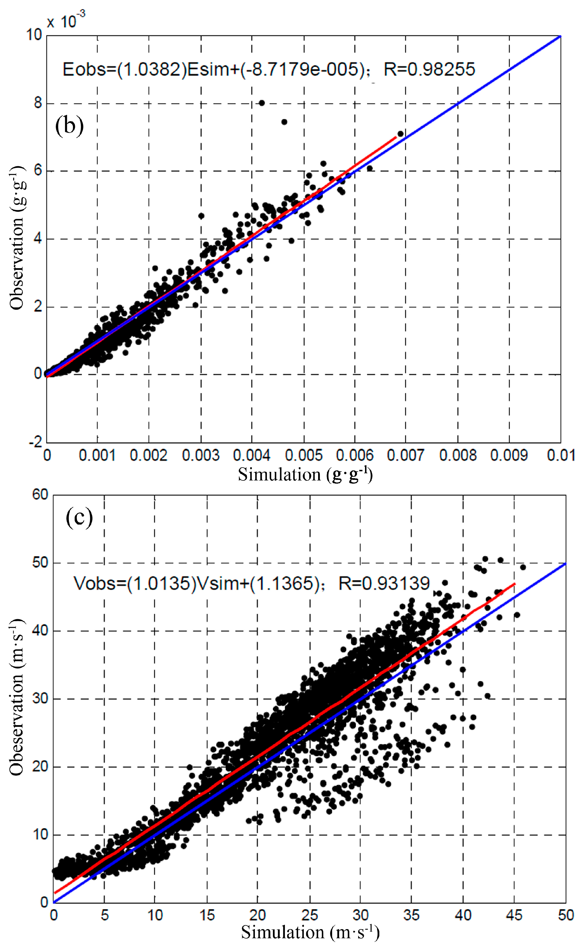
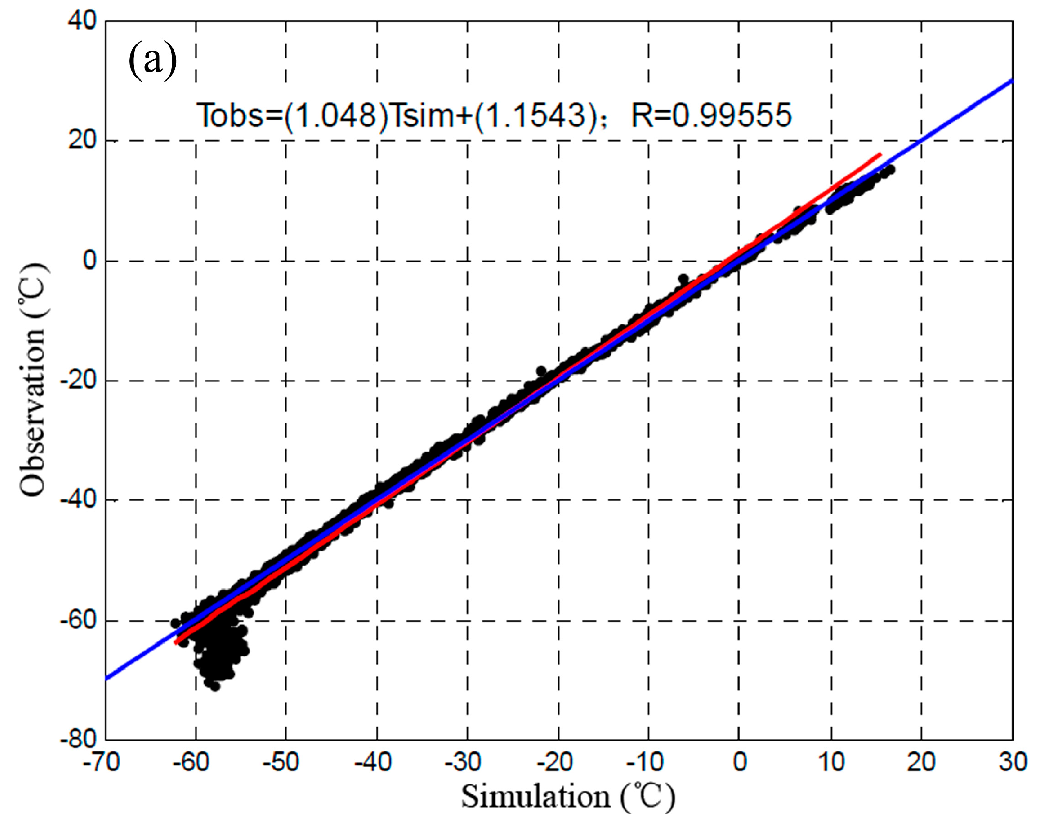
Before climate and hydrological model coupling, we verified the high-resolution RCM based on RIEMS with high resolution and precision. The correlation coefficients of precipitation, temperature, specific humidity, and wind speed are all above 0.8, with 0.01 significance levels. Spatial and temporal resolutions reached 3 km × 3 km and 6 h, respectively. RIEMS can represent watershed weather variability, but it has less satisfactory results with wet season precipitation of some years. In addition, we proposed a one-way coupling method by building abundant and evenly distributed virtual weather stations based on RIEMS. We also used the climate model that served as input parameters for the hydrological model. By using this method to capture spatial heterogeneity of weather variability accurately, deficiencies of scarce and unevenly distributed meteorological observations stations were compensated, and optimisation of SWAT weather input parameters was achieved. Considering the natural characteristics of watersheds, we followed the principles of multi-temporal calibration, multi-variable calibration, and multi-site calibration. We also simulated the monthly runoff process. According to statistical evaluation, NSEs were higher than 0.65, R2 values exceeded 0.70, PBIAS values were controlled in the range of ±20%, and RSRs were less than 0.65. These results prove that the coupling model has a fair applicability to simulate the runoff process in the upper reaches of HRB.
Future studies should focus on improving the numerical simulation accuracy of high-resolution RCM. We should also modify the spatial discretisation scheme of the hydrological model and choose the two-way coupling method. Developing the coupled climate–hydrological model research in the upper reaches of HRB will also contribute scientific support for the prediction and management of water resources, as well as assist in further research on the responses of water resources to global climate change and human activities.


