Article

Comparison of Four Different Energy Balance Models for Estimating Evapotranspiration in the Midwestern United States

by
Ramesh K. Singh
1,* and
Gabriel B. Senay
2
1
ASRC Federal InuTeq, Contractor to the U.S. Geological Survey (USGS) Earth Resources Observation and Science (EROS) Center, 47914 252nd Street, Sioux Falls, SD 57198, USA
2
USGS EROS Center, North Central Climate Science Center, Colorado State University, Fort Collins, CO 80523, USA
*
Author to whom correspondence should be addressed.
Water 2016, 8(1), 9; https://doi.org/10.3390/w8010009
Submission received: 19 October 2015 / Revised: 9 December 2015 / Accepted: 16 December 2015 / Published: 26 December 2015

Abstract

:
The development of different energy balance models has allowed users to choose a model based on its suitability in a region. We compared four commonly used models—Mapping EvapoTranspiration at high Resolution with Internalized Calibration (METRIC) model, Surface Energy Balance Algorithm for Land (SEBAL) model, Surface Energy Balance System (SEBS) model, and the Operational Simplified Surface Energy Balance (SSEBop) model—using Landsat images to estimate evapotranspiration (ET) in the Midwestern United States. Our models validation using three AmeriFlux cropland sites at Mead, Nebraska, showed that all four models captured the spatial and temporal variation of ET reasonably well with an R2 of more than 0.81. Both the METRIC and SSEBop models showed a low root mean square error (<0.93 mm·day−1) and a high Nash–Sutcliffe coefficient of efficiency (>0.80), whereas the SEBAL and SEBS models resulted in relatively higher bias for estimating daily ET. The empirical equation of daily average net radiation used in the SEBAL and SEBS models for upscaling instantaneous ET to daily ET resulted in underestimation of daily ET, particularly when the daily average net radiation was more than 100 W·m−2. Estimated daily ET for both cropland and grassland had some degree of linearity with METRIC, SEBAL, and SEBS, but linearity was stronger for evaporative fraction. Thus, these ET models have strengths and limitations for applications in water resource management.

Graphical Abstract

1. Introduction

Modeling evapotranspiration (ET), the combined loss of water from soil through evaporation and from vegetation through transpiration, has many applications in agricultural management [1,2], carbon sequestration [3,4], climate modeling [5], drought monitoring [6], energy security [7], hydrological modeling [8], irrigation scheduling [9], and watershed development [10,11]. Various models and techniques are used for accurately estimating ET at field to global scales. Many techniques such as lysimeters, sap flow, eddy covariance method, Bowen ratio system, and scintillometer are accurate and efficient but cannot be used for regional-to-global scale ET mapping due to prohibitive cost and logistical limitations.
The availability of no-cost satellite images, advances in computing technology, and affordability of computing resources has allowed the development and use of remotely sensed images for water use estimation. Remotely sensed images are increasingly used for estimating ET at different temporal and spatial scales. During the last two decades, many models were developed for estimating land surface evapotranspiration using remotely sensed data [12,13,14]. Some of these models include SEBAL (Surface Energy Balance Algorithm for Land) [15,16], SEBS (Surface Energy Balance System) [17], METRIC (Mapping EvapoTranspiration at high Resolution with Internalized Calibration) [18], and SSEBop (Operational Simplified Surface Energy Balance) models [19,20]. The SEBAL model has been widely used under different climatic conditions at both field and catchment scales with a typical accuracy of 85% at field scale on a daily basis and increasing to 95% on a seasonal basis [21]. Application of the SEBS model over 20 FLUXNET sites encompassing grassland, cropland, shrubland, evergreen needleleaf forest, and deciduous broadleaf forest showed promising results with the Nash–Sutcliffe efficiency (NSE) and the root mean squared difference (RMSD) of 0.42 and 84 W·m−2, respectively [22]. Use of the METRIC model over an irrigated cotton field in Maricopa, Arizona, at fine and moderate spatial scales showed an RMSD of less than 1.9 mm·day−1, and METRIC was preferred when model ancillary data were sparse [23]. The SSEBop model-based estimation of ET in the Colorado River Basin with diverse ecosystems and complex hydro-climatic regions nicely captured the variability in annual ET with an overall coefficient of determination (R2) of 0.78 and a mean bias error of about 10%. Thus, all of these models used by different research groups have worked well in different areas. However, selecting a model for estimating ET from many available energy balance models is challenging as each model has its strengths and limitations like any other modeling approaches.
Comparison of different models for estimating reference/potential ET has helped users and researchers in standardizing and identifying the best model for specific regions and climatic conditions [1,24,25,26]. Similarly, comparison of different models for estimating actual ET provides important information on suitability and limitations of models to users and developers. These comparisons help users understand the strength/limitations of different techniques and better understand the uncertainties in various model components and their impacts on final ET values [2]. Different models for ET estimation have different input data requirements and influence the model selection based on input data availability. In addition, the source of input data may also influence the model performance based on the quality and accuracy of the input data. Comparison of three energy balance models using measured values of net radiation (Rn) and soil heat flux (G) showed comparable results but inter-model discrepancies are likely to be greater if the model estimates of Rn and G are used [27]. The complexities of various models are different and affect the ease of model set-up and operational efficiency. Research has shown that added complexities do not necessarily lead to improved performance of hydrological models [28]. Performance of ET models may also vary seasonally depending upon rainfall distribution. The SEBAL model gave comparable results to the water balance method during the rainy season but a higher value during the dry season [29]. Another study on the comparison of methods for estimating forest evapotranspiration showed the effects of severe surface dryness and rainfall events [30]. Comparison of a radiometric surface temperature-based energy balance model and reflectance-based vegetation indices model have shown that the later model may be less sensitive to detecting crop water stress and estimating ET until there is actual reduction in biomass or changes in canopy geometry [27,31].
Based on the literature, it is evident that models may have overall high performance, but there are substantial differences in capturing the spatial and temporal variability of ET under diverse agro-hydro-climatic conditions, thus highlighting the need for further improvement and validation [32]. The objective of this study is to compare four commonly used ET models—Mapping EvapoTranspiration at high Resolution with Internalized Calibration (METRIC) model, Surface Energy Balance Algorithm for Land (SEBAL) model, Surface Energy Balance System (SEBS) model, and Operational Simplified Surface Energy Balance (SSEBop) model—using 2001 Landsat images to estimate ET in the Midwestern United States.

2. Materials and Methods
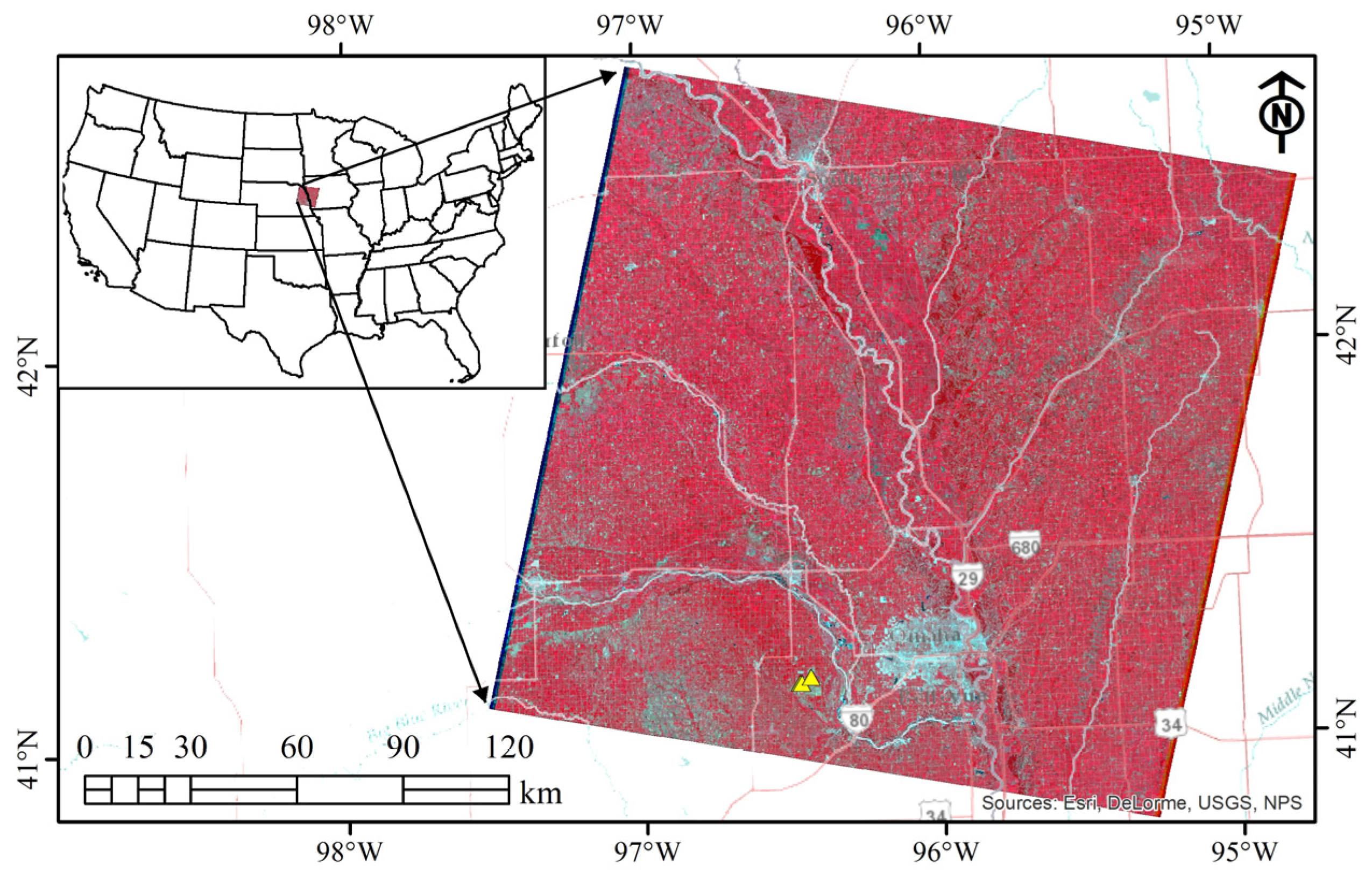
2.1. Study Area

This study was conducted in the Midwestern United States in a relatively flat plain dominated by croplands, mainly maize and soybean fields. We used Landsat satellite images (path 28, row 31) acquired on 4 July, 5 August, 24 October, and 11 December (Landsat 5, Thematic Mapper: TM) and four images acquired on 13 August, 29 August, 30 September, and 16 October (Landsat 7, Enhanced Thematic Mapper Plus: ETM+) during the 2001 crop growing season (Figure 1). The Landsat images were processed using Erdas Imagine software (Hexagon Geospatial Inc., Norcross, GA, USA) based on standard procedure where digital number values are first converted to radiance and then to reflectance [20]. The University of Nebraska Agricultural Research and Development Center (ARDC) near Mead, Nebraska, within the Landsat scene footprint has three eddy covariance (EC) measurements sites. These three sites are Mead Site 1: center-pivot irrigated continuous maize (41°9′54.2″ N, 96°28′35.9″ W, 361 m above mean sea level, area 48.7 ha); Mead Site 2: center-pivot irrigated maize-soybean rotation (41°9′53.5″ N, 96°28′12.3″ W, 362 m above mean sea level, area 52.4 ha); and Mead Site 3: rainfed maize–soybean rotation (41°10′46.8″ N, 96°26′22.7″ W, 362 m above mean sea level, area 65.4 ha). Only maize was grown at all three sites under no-till management during the 2001 crop growing season employing the best management practices. Maize was planted on 10 May, 11 May, and 14 May and harvested on 18 October, 22 October, and 29 October, respectively, at Mead Sites 1–3. The fluxes were measured using an omnidirectional 3D sonic anemometer (Model R3: Gill Instruments Ltd., Lymington, UK), a closed-path infrared CO2/H2O gas analyzing system (Model LI6262: Li-Cor Inc., Lincoln, NE, USA), and a krypton hygrometer (Model KH20: Campbell Scientific, Logan, UT, USA). Additional details about the sites, installation, operation and maintenance of the EC tower, data processing, and quality control are given elsewhere [33].
Figure 1. Location map of the study area for Landsat path 28, row 31. Eddy covariance sites are also shown using yellow triangles just southwest of Omaha, Nebraska, (blue-gray color) in the lower middle part of the image.
Water 08 00009 g001

2.2. Energy Balance Models

We provide a brief overview of the models used in this study, and full details of the models are provided in their respective references. A brief overview of data used in this study is provided in Table 1.
Table 1. Overview of datasets used in this study.
No.DatasetSymbolSourceResolution
1ElevationzDEM30 m
2Surface temperatureTsLandsat60/120 m
3Normalized Difference Vegetation Index-Landsat30 m
4AlbedoαLandsat30 m
5Momentum roughness lengthZomNDVI30 m
6Temperature differencedTModel1 km
7Flux ET-Eddy covariance-
8Extraterrestrial solar radiationRaModel-
9Alfalfa reference ETETrWeather station-
10Grass reference ETEToGDAS10 km

2.2.1. The METRIC Model

The METRIC model, a variant of the SEBAL model, estimates ET as a residual of the surface energy balance equation:
L E = R n G H
where LE is latent heat flux (W·m−2) consumed for ET, Rn is net radiation (W·m−2), G is soil heat flux (W·m−2), and H is sensible heat flux (W·m−2).
The innovative aspect of the METRIC model is that it uses weather-based reference ET, thus using ground-based reference ET to tie down satellite-based actual ET. In addition, use of daily water balance to compute ET at a hot anchor pixel helps to account for the residual soil moisture content.
ET at each pixel at the time of satellite overpass is calculated as
E T i n s = 3600 × L E λ × ρ w
where ETins is instantaneous ET (mm·h−1), λ is latent heat of vaporization (J·kg−1), and ρw is density of water (kg·m−3).
The reference ET fraction (ETrF) is computed as
E T r F = E T i n s E T r
where ETr is tall grass (alfalfa) reference ET (mm·h−1) at the time of satellite overpass calculated from data collected at a nearby weather station. It is assumed that the ETrF computed for the time of satellite overpass is the same as the ETrF over the 24-h average.
Finally, daily ET (ET24) at each pixel is computed as
E T 24 = E T r F × E T r _ 24
where ETr_24 is the cumulative 24-h daily ETr (mm·day−1) using the standardized ASCE (American Society of Civil Engineers) Penman–Monteith equation for the day of satellite image acquisition. More details about the METRIC model can be found in [2,18].

2.2.2. SEBAL Model

The SEBAL model, a physically based multi-step surface energy balance model, provided a pioneering approach for land surface parameterization based on near-surface vertical air temperature difference. This vertical temperature difference (dT) between aerodynamic surface temperature and air temperature was assumed to be linearly related to the remotely sensed radiometric surface temperature. This approach excluded the need for independent synoptic air temperature observations for a correct physical coupling between the surface roughness for heat transport, vertical temperature gradient, and fluxes [16]. This dT parameterization also alleviated the need for accurate estimation of radiometric surface temperature due to uncertainty caused by atmospheric attenuation, radiometric calibration, and contamination [2].
Based on Rn, G, and H computations at the time of satellite overpass, the evaporative fraction (EF) at each pixel of the image is computed as
E F = R n G H R n G
The EF computed for the time of satellite overpass is assumed to be constant over the 24-h period for the day of image acquisition. Thus, daily ET at each image pixel is calculated as
E T 24 = 8.64 × 10 7 × E F × ( R n 24 G 24 ) λ × ρ w
where Rn24 is daily average net radiation (W·m−2), the difference between incoming net shortwave radiation and outgoing net longwave radiation, and G24 is daily average soil heat flux (W·m−2) usually assumed to be zero for soil and vegetation surfaces. Rn24 is computed as
R n 24 = ( 1 α ) × R a × τ s w 110 × τ s w
where Ra is daily extraterrestrial solar radiation (W·m−2), and τsw is daily atmospheric transmittance affected by dust, humidity, and other pollutants in the air. More details about the SEBAL model can be obtained from [2,16,21].

2.2.3. SEBS Model

The SEBS model is another physically based energy balance model that does not require any a priori knowledge of the actual turbulent heat fluxes. The model uses energy balance at wet and dry limiting conditions to compute instantaneous relative evaporation (Λr) as
Λ r = 1 H H w e t H d r y H w e t
where Hwet is sensible heat flux (W·m−2) under the wet limiting condition where ET takes place at potential rate, and Hdry is sensible heat flux (W·m−2) at the dry limiting condition where ET is zero due to limited soil moisture.
The daily evaporative fraction is formulated as
Λ = Λ r × L E w e t R n G
Finally, the daily ET is computed as
E T 24 = 8.64 × 10 7 × Λ × ( R n 24 G 24 ) λ × ρ w
Additional details on the SEBS model are provided by [17,34]. The SEBS model consists of a set of tools for determining land surface parameters including roughness length for heat transfer for estimating evaporative fraction and ET based on energy balance at limiting cases [17].

2.2.4. SSEBop Model

The SSEBop model is based on a simplified surface energy balance principle that does not solve for H explicitly like METRIC, SEBAL, and SEBS, as these three models use the Monin–Obukhov Similarity theory for stability correction functions for momentum and sensible heat transfer. The innovative aspect of the SSEBop model is that it is based on a predefined differential temperature dT to define two extreme limiting surface temperatures: Cold temperature (Tc) in case of little or no sensible heat flux and hot temperature (Th) in case of little or no latent heat flux. The innovative parameterization procedure for hot and cold limiting conditions eliminated the subjectivity that could be introduced during the manual hot and cold reference selection.
The ET fraction (ETf) is computed as
E T f = T h T s d T
where Th is idealized reference hot pixel temperature (K), Ts is radiometric land surface temperature (K), and dT is predefined temperature difference between hot and cold reference conditions that is representative of temperature difference between bare dry surface and air. The Tc is estimated from the daily maximum air temperature, and Th is then calculated as the sum of Tc and dT.
The daily ET is calculated as
E T 24 = E T f × k × E T 0
where ETo is short grass reference ET (mm·day−1) and k is a scaling coefficient based on calibration (here we used k as 1). Additional details on the SSEBop model can be obtained from [19,20].

2.3. Models Validation

We estimated actual ET based on the METRIC, SEBAL, SEBS, and SSEBop models using Landsat images acquired on eight dates. The estimated ET for the pixel that has a flux tower was compared with the eddy covariance measurements (Level 4: gapfilled and adjusted data) at three sites discussed in Section 2.1. Validation of the estimated ET was done by comparing estimated ET for the pixel located at the flux tower site with that of flux tower actual measurement of ET. We have three flux tower sites; thus for eight satellite overpass dates, we have 24 (8 × 3) pairs of data for validation. We used different statistical measures to evaluate the model performance at the validation sites. These statistical measures included Pearson’s correlation coefficient (r), coefficient of determination (R2), relative error (RE), root mean square error (RMSE), mean bias error (MBE), mean absolute error (MAE), and Nash–Sutcliffe’s efficiency (NSE). It was assumed that any discrepancies between observed and estimated ET is due to error in estimated ET. However, in reality, there are also uncertainties associated with the eddy covariance measurements due to instrument sampling error, source area, failure to account for all the mechanisms of aerodynamic transport of energy, and other random observation errors. Additional details on these issues can be found in [22,35].

3. Results and Discussion

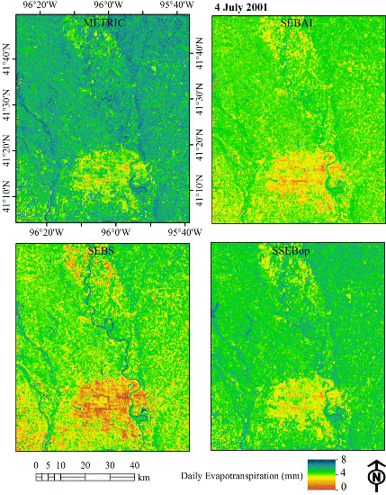
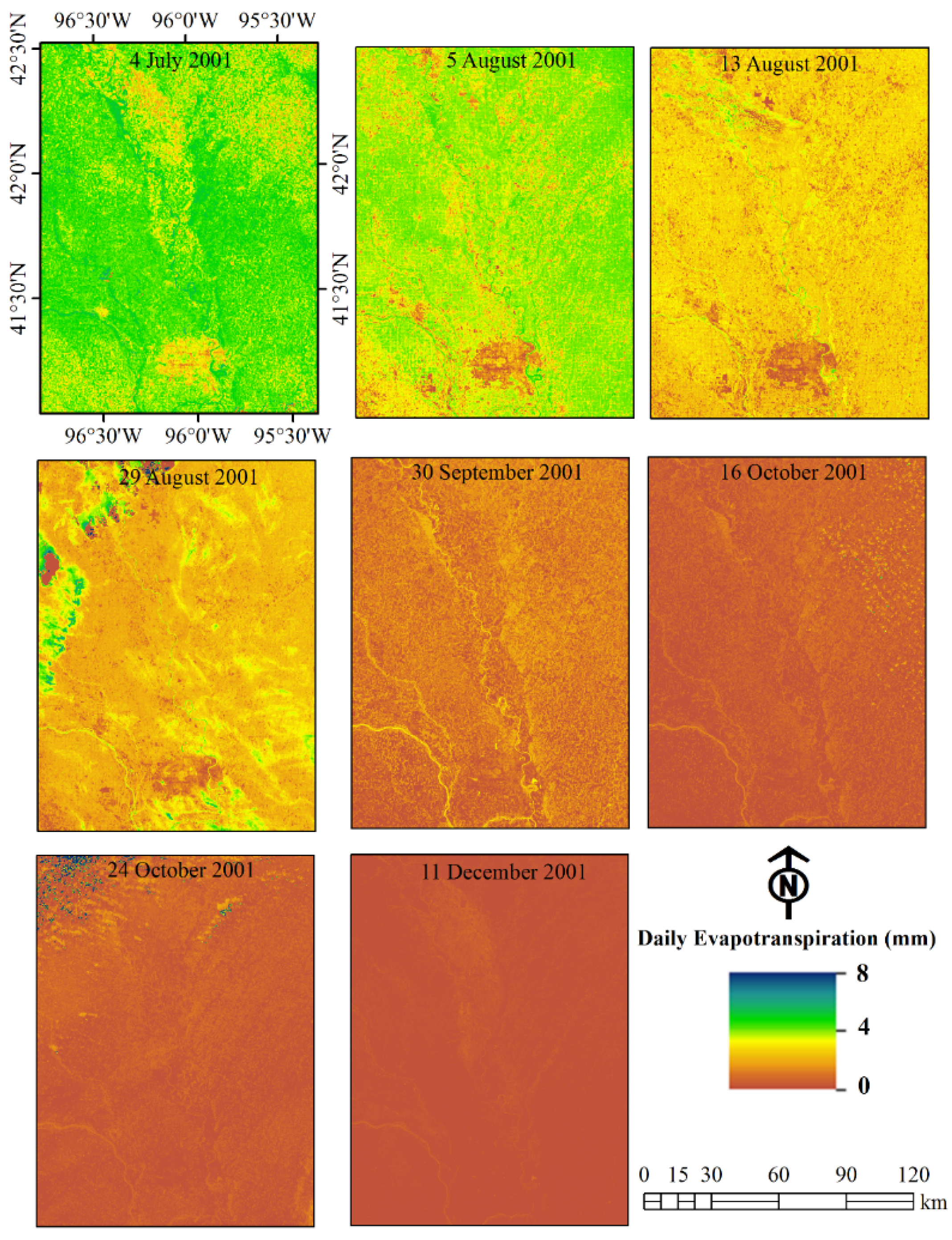
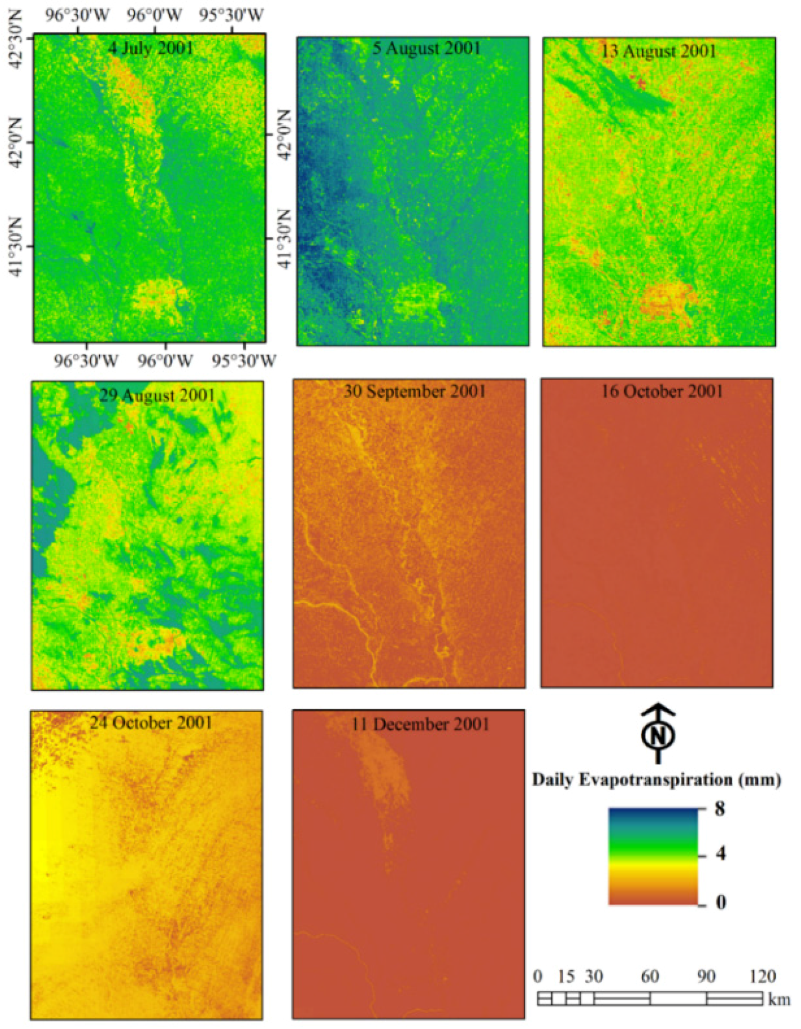
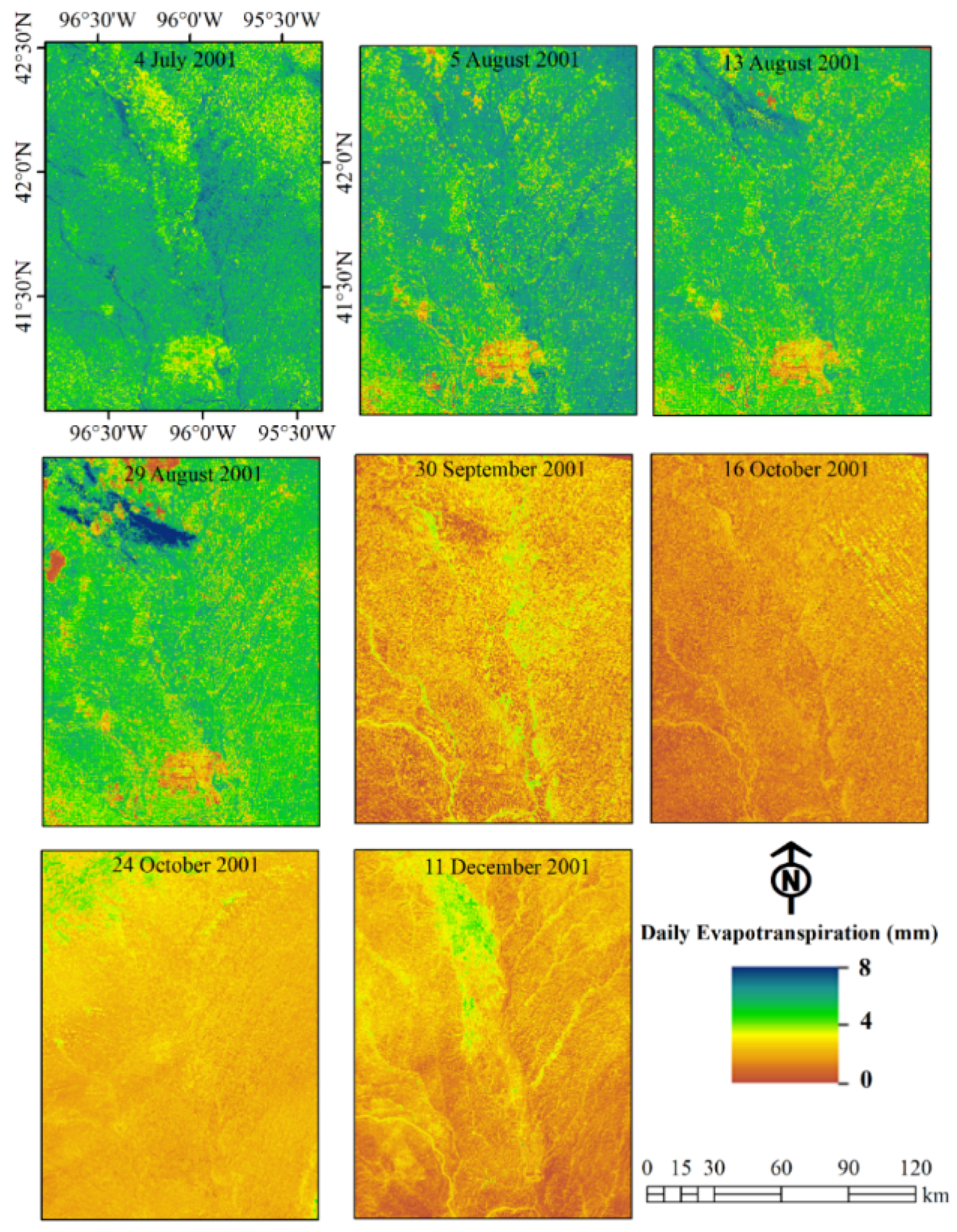
3.1. Spatial and Temporal Variation of ET Using the METRIC Model

The ET map based on the METRIC model showed the spatial and temporal variation of ET within the study area (Figure 2). As expected, ET was higher during the growing season than during the non-growing season. The urban area (Omaha, NE, USA) in the lower middle part of the image can be seen distinctly in the first four ET maps, but not in the last four ET maps due to the lower ET of urban areas as compared to the surrounding agricultural and natural vegetated areas. ET was also higher for the river and riparian areas along the river compared to other areas. In general, ET was high over the study area on 4 July 2001 due to higher residual moisture content from a previous precipitation event. Table 2 shows the evaporation coefficient (Ke) for the hot pixel based on soil water balance run on a daily basis. Ke was also high on 24 October 2001 but its effect on ET in the study area was minimal due to a localized precipitation event. High residual moisture content of the hot pixel may cause underestimation of sensible heat flux at the anchoring pixels in the conventional METRIC model, thus, increasing the uncertainty of the estimated ET [36].
Alfalfa-based reference ET (ETr) is used in the METRIC model for calibrating the energy balance functions and upscaling the instantaneous ET to daily ET. ET in many irrigated fields in arid and semiarid regions can exceed net radiation due to advection effects. Use of ETr in the METRIC model helps to compensate to certain extent for regional advection [2,36].
Selection of hot and cold pixels in the METRIC model is important for accurate estimation of ET. The hot pixel is generally selected from a dry, bare agricultural field that does not necessarily have the highest Ts value. Similarly, the cold pixel is selected from well-watered and fully covered vegetation representative of the agricultural area. Thus, the METRIC model, like other models requiring selection of hot and cold pixels, relies on the user’s ability to select appropriate anchoring pixels [2,37].
Figure 2. Daily evapotranspiration map for the days of satellite overpasses based on the Mapping EvapoTranspiration at high Resolution with Internalized Calibration (METRIC) model.
Water 08 00009 g002
Table 2. Evaporation coefficient (Ke) for the hot pixel used in the Mapping EvapoTranspiration at high Resolution with Internalized Calibration (METRIC) model on the date of satellite overpasses.
Date4 July 20015 August 200113 August 200129 August 200130 September 200116 October 200124 October 200111 December 2001
Ke0.63000.310.110.250.620.22

3.2. Spatial and Temporal Variation of ET Using the SEBAL Model

The variations of ET both spatially and temporally using the SEBAL model are shown in Figure 3. Overall, the ET values for SEBAL were lower as compared to the METRIC model-based ET values, particularly during the end of the growing season. This is surprising as we used the same hot/dry and cold/wet pixels (anchor pixels) for both the METRIC and the SEBAL models run for a particular day of satellite overpass. Studies have shown that some uncertainties are introduced in the model output due to subjectivity associated with the selection of anchor pixels [37,38]. However, in our case, lower values of ET of the SEBAL model are not associated with the anchor pixels selection, as we used the same anchor pixels as those used in the METRIC model. Thus, it is most likely that differences in ET estimates between the METRIC and SEBAL models in this study can be attributed to two factors: (1) differences in how ETrF and EF are computed; and (2) upscaling methods for converting instantaneous ET to daily ET. The ETrF in the METRIC model is computed based on instantaneous ET and reference ET at the time of satellite overpass (Equation (3)). Thus, weather observations (temperature, humidity, wind speed, and solar radiation) from the nearby automated weather station are used to tie down the METRIC model output. On the other hand, EF in the SEBAL model is solely based on the instantaneous latent heat, soil heat, and sensible heat fluxes (Equation (5)). In addition, any advection effect cannot be accounted for in the SEBAL model but it is accounted for to some extent in the METRIC model due to use of weather data in ETr [36]. Furthermore, instantaneous ET is upscaled using daily reference ET (Equation (4)) in the METRIC model, whereas upscaling is done using daily average net radiation (Equation (7)) in the SEBAL model. In this study, we did not use field-measured daily net radiation but computed daily average net radiation based on daily extraterrestrial solar radiation, albedo, and daily atmospheric transmittance. This aspect is further discussed in Section 3.5 and Section 3.6.
Figure 3. Daily evapotranspiration map for the days of satellite overpasses based on the Surface Energy Balance Algorithm for Land (SEBAL) model.
Water 08 00009 g003

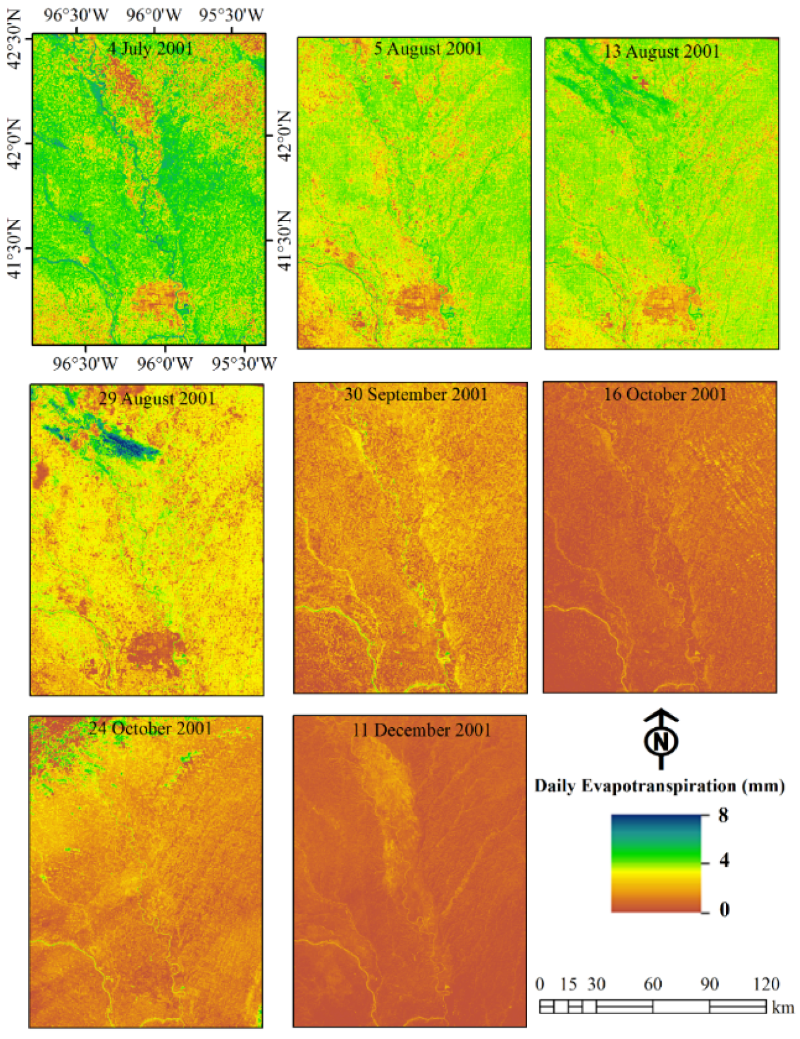
3.3. Spatial and Temporal Variation of ET Using the SEBS Model

The progression of ET over the study area from July to December was captured by the SEBS model showing good spatial and temporal variations (Figure 4). The transition from high ET values on 4 July 2001 to low ET values on 11 December 2001 was gradual. SEBS showed more variation in the distribution of ET on the last image date (11 December 2001), than SEBAL ET on 11 December 2001. The ability of the SEBS model to capture the spatial variability has been used in precision agriculture [39]. The ET from the urban area (Omaha, Nebraska) located in the lower middle part of the image is consistent, particularly during July–August. In general, SEBS-estimated ET values were lower than METRIC-estimated ET but higher than SEBAL-estimated ET. However, all three models showed a decreasing trend in ET, as expected with the monthly progression from July to December. It should be noted that daily ET in both SEBAL and SEBS were upscaled using the same daily average net radiation equation (Rn24 = (1 − α) × Ra24 × τsw − 110 × τsw) where α is albedo, Ra24 is daily extraterrestrial solar radiation (W·m−2), and τsw is daily atmospheric transmittance. However, the spatial distribution of SEBS-based ET was different from SEBAL-based ET, particularly on 13 August, 24 October, and 11 December 2001.
Figure 4. Daily evapotranspiration map for the days of satellite overpasses based on the Surface Energy Balance System (SEBS) model.
Water 08 00009 g004

3.4. Spatial and Temporal Variation of ET Using the SSEBop Model

Spatial variation and temporal distribution of ET within the study area using the SSEBop model is shown in Figure 5. Unlike METRIC, SEBAL, and SEBS model-based ET, the SSEBop based-ET was the highest for the image acquired on 5 August 2001. This finding was in agreement with the observation that the highest alfalfa reference ET (8.46 mm) among all eight dates was observed on 5 August (Table 3). There were general similarities in ET spatial patterns on 4 July, 5 August, and 13 August 2001 using the METRIC model, whereas different spatial patterns were observed on these dates using the SSEBop model. It should be noted that station-based ETr was used in the METRIC model for upscaling instantaneous ET to daily ET, whereas Global Data Assimilation System (GDAS)-based short grass reference ET (ETo) was used in the SSEBop model for computing daily ET. GDAS-based ETo is a gridded product, thus it captures spatial variability of evaporative demand of the atmosphere better than a single value of ETr for the entire image. All ET models used in this study showed higher ET on 24 October as compared to ET on 16 October due to high residual moisture content owing to previous precipitation events (Table 2) and high reference ET (Table 3). However, SSEBop-based ET pattern on 24 October was more in agreement with METRIC-based ET as compared to SEBAL-based ET. ET was minimal on 11 December, consistent with other models due to low evaporative demand of the atmosphere during the winter. However, the SEBS model based ET map has higher spatial variability as compared to the SSEBop model-based ET map on 11 December.
Figure 5. Daily evapotranspiration map for the days of satellite overpasses based on the Operational Simplified Surface Energy Balance (SSEBop) model.
Water 08 00009 g005
Table 3. Area weighted average (81,921 pixels) short grass reference ET (ETo) from global data assimilation system and alfalfa reference ET (ETr) from weather station data for the day of satellite overpasses. Both ETo and ETr values are in mm·day−1.
Date4 July 20015 August 200113 August 200129 August 200130 September 200116 October 200124 October 200111 December 2001
ETo5.676.524.824.752.081.351.900.73
ETr6.738.466.307.584.493.003.612.66

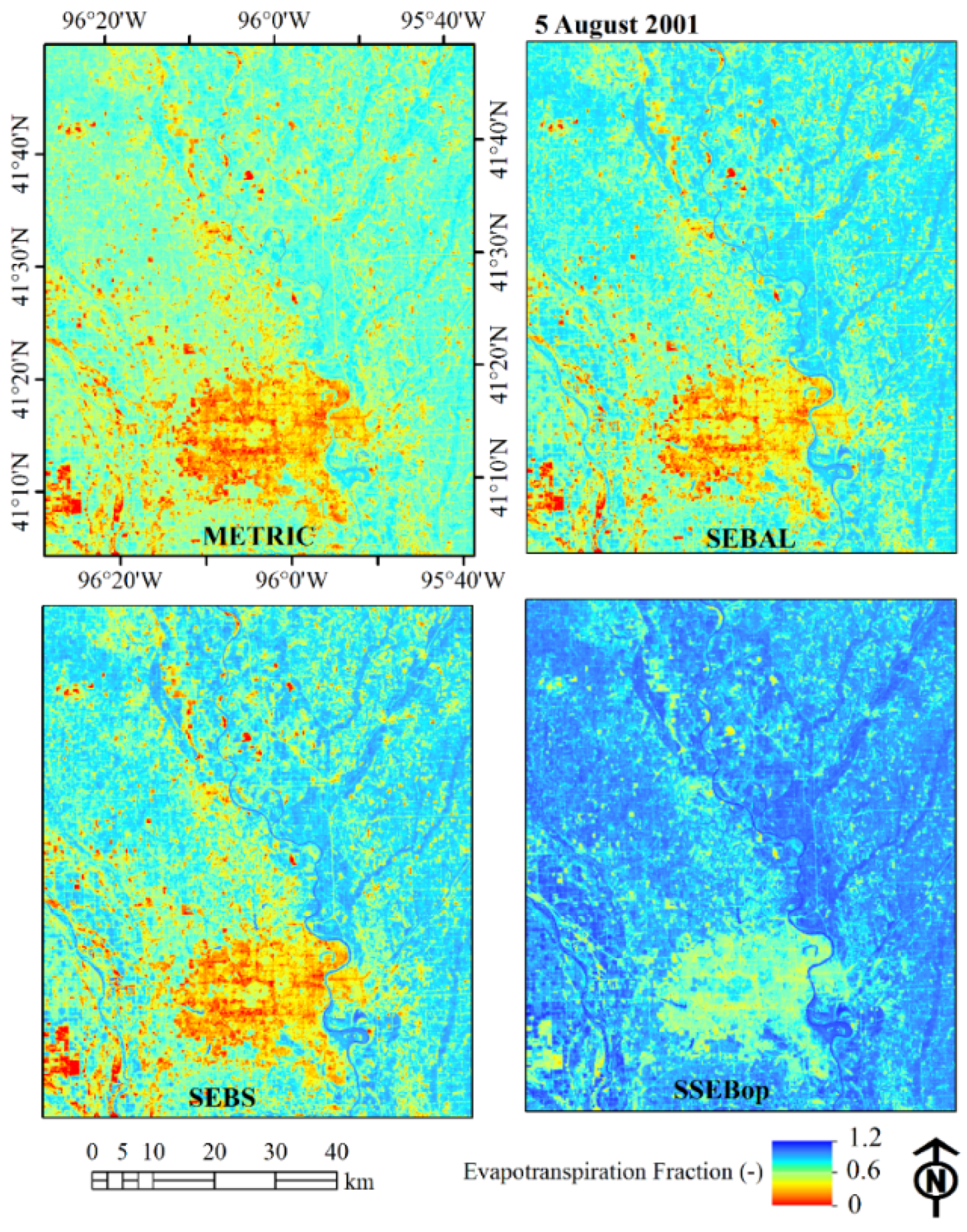
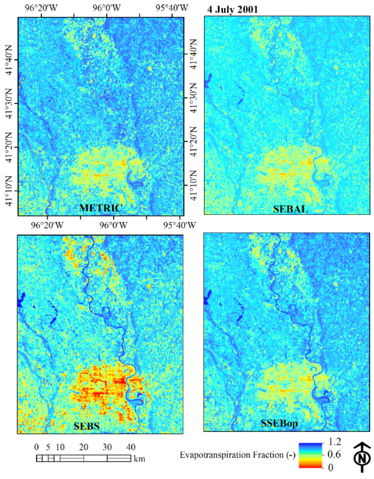
3.5. Spatial Variation of Evaporative Fraction from Different Models on Selected Dates

As discussed in Section 2, remotely sensed images are first used for computing evaporative fraction at the time of satellite overpass before computing daily ET. The evaporative fraction based on METRIC (ETrF), SEBAL (EF), SEBS (Λ), and SSEBop (ETf) models on 4 July 2001 and 5 August 2001 are shown in Figure 6 and Figure 7, respectively. A similar pattern with minor differences was observed for the evaporative fraction within the study area on 4 July 2001 and 5 August 2001 using all four ET models. As compared to ET maps for these two dates using four models (Figure 2, Figure 3, Figure 4 and Figure 5), there was less variability among evaporative fraction maps (Figure 6 and Figure 7). The urban areas have little lower evaporative fraction on 4 July 2001 using the SEBS model (Figure 6). Similarly, urban areas have little higher evaporative fraction on 5 August 2001 using the SSEBop model (Figure 7). In general, evaporative fraction is similar to the commonly used crop coefficient approach in crop water requirement computation. Generally, evaporative fraction ranges from 0 to 1 and may be a little higher than 1 for recently watered land either due to irrigation or precipitation for alfalfa or maize crops [2]. The evaporative fraction is mostly expected to be relatively constant during the day of the satellite overpass, thus it is used for upscaling instantaneous ET to daily ET [40,41,42].
Figure 6. Evaporative fraction map computed using the METRIC, SEBAL, SEBS, and SSEBop models from the Landsat image acquired on 4 July 2001.
Water 08 00009 g006
Figure 7. Evaporative fraction map computed using the METRIC, SEBAL, SEBS, and SSEBop models from the Landsat image acquired on 5 August 2001.
Water 08 00009 g007

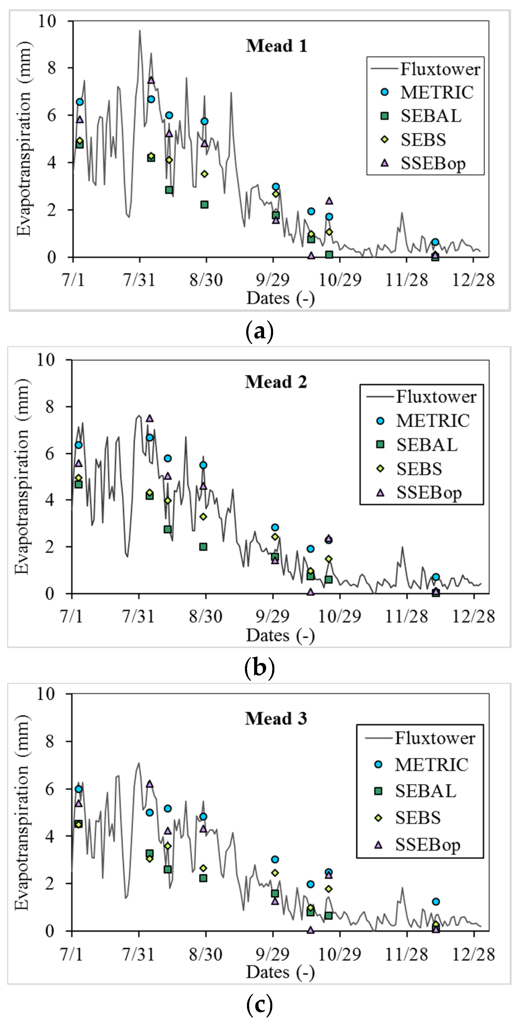
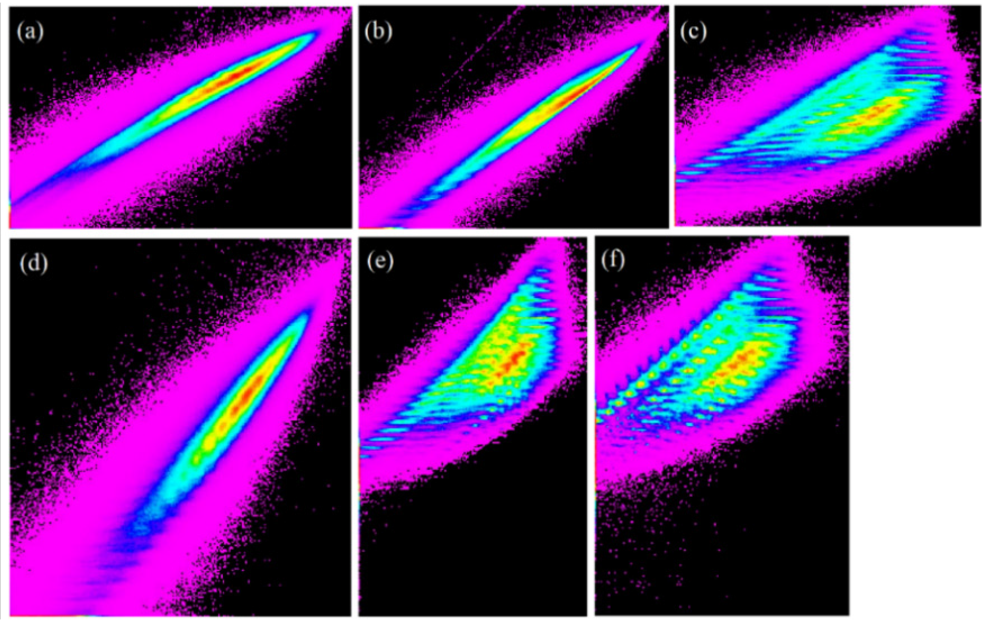
3.6. Comparison of Estimated ET with the Eddy Covariance Measurements

Comparison of estimated ET with the field-measured ET gives confidence in the efficacy of any particular model in ET modeling. Our comparison of estimated ET with the measured ET showed that some of the models were effective in tracking the variation of actual ET at all three sites (Figure 8). In general, ET values were relatively higher during the month of July, August, and September and then started to decrease with crop maturity. With the harvest of crops in the second half of October, ET was mostly less than 1 mm·day−1.
Figure 8. Temporal variation of evapotranspiration measured using eddy covariance at Mead Site 1 (a); Mead Site 2 (b); and Mead Site 3 (c) during 2001. ET estimated using the METRIC, SEBAL, SEBS, and SSEBop models on the days of satellite overpasses are also shown.
Water 08 00009 g008
Our statistical analysis showed that both the METRIC and SSEBop models performed well at the Mead Sites 1 and 2 with RMSE less than 1 mm·day−1 (Table 4). The MAE at the Mead Site 1 ranged from 0.73 mm·day−1 (METRIC) to 1.87 mm·day−1 (SEBAL) with NSE values of 0.91 and 0.28, respectively. Both SEBAL and SEBS models underestimated ET at the Mead sites. This underestimation was more pronounced, particularly on days of high ET values. This underestimation of ET using the SEBAL and SEBS models is due to use of an empirical formula of daily average net radiation for upscaling instantaneous ET to daily ET. Our analysis of measured and computed Rn24 showed that using Equation (7) resulted in good correlation (r = 0.98, R2 = 0.97, NSE = 0.65), but there was substantial bias (MBE = −32.17 W·m−2, RMSE = 44.13 W·m−2 (34.9%)). Equation (7) worked well when the daily average net radiation values were less than 100 W·m−2 but underestimated Rn24 when the actual Rn24 was higher than 100 W·m−2. Equation (7) should be calibrated before use to account for local atmospheric conditions. Another study showed the need for improving daily average net radiation estimation for extrapolating instantaneous ET to daily ET [43]. Furthermore, the high uncertainty of the SEBS model due to parameterization errors of roughness length, aerodynamic resistance, and temperature gradient, also has been reported by other researchers [22,44].
The performance of the METRIC model at the dryland Mead Site 3 was not as good as the performance of the SSEBop model. The MAE of the METRIC model at the Mead Site 3 was 0.98 mm·day−1 (29.90%), compared to 0.66 mm·day−1 (20.26%) for the SSEBop model. The RMSE was 1.06 mm·day−1 and 0.73 mm·day−1 for the METRIC and SSEBop models, respectively. Similarly, NSE at this site was 0.79 and 0.90 for the METRIC and SSEBop models, respectively. Subdued performance of the METRIC model at the Mead Site 3 may be attributed to the nonirrigated condition of this site. The assumption of constant ETrF during a day may not be valid under water stressed conditions [2].
Table 4. Comparison statistics for three flux sites based on Pearson’s correlation coefficient (r), coefficient of determination (R2), relative error (RE), mean absolute error (MAE), mean bias error (MBE), root mean square error (RMSE), and Nash–Sutcliffe’s efficiency (NSE) using the METRIC, SEBAL, SEBS, and SSEBop models.
ParametersMETRIC ModelSEBAL ModelSEBS ModelSSEBop Model
Mead Site 1Mead Site 2Mead Site 3Mead Site 1Mead Site 2Mead Site 3Mead Site 1Mead Site 2Mead Site 3Mead Site 1Mead Site 2Mead Site 3
r (-)0.970.970.940.880.930.920.910.940.830.970.950.95
R2 (-)0.940.950.880.780.860.850.830.890.680.940.900.91
RE (%)2.511.613.7−47.2−42.6−39.6−31.1−25.0−26.0−12.6−7.1−8.1
MAE (mm·day−1)0.730.710.981.871.481.291.481.151.230.740.720.66
MAE (%)18.4419.8129.9047.6341.2639.5937.6431.8437.6018.8520.0020.26
MBE (mm·day−1)0.100.460.45−1.86−1.67−1.29−1.22−0.96−0.85−0.50−0.22−0.27
MBE (%)2.5312.7113.71−47.21−46.40−39.59−31.11−26.77−25.99−12.63−6.18−8.15
RMSE (mm·day−1)0.880.841.062.462.011.741.961.531.670.900.880.73
NSE (-)0.910.900.790.280.420.430.540.660.470.900.890.90

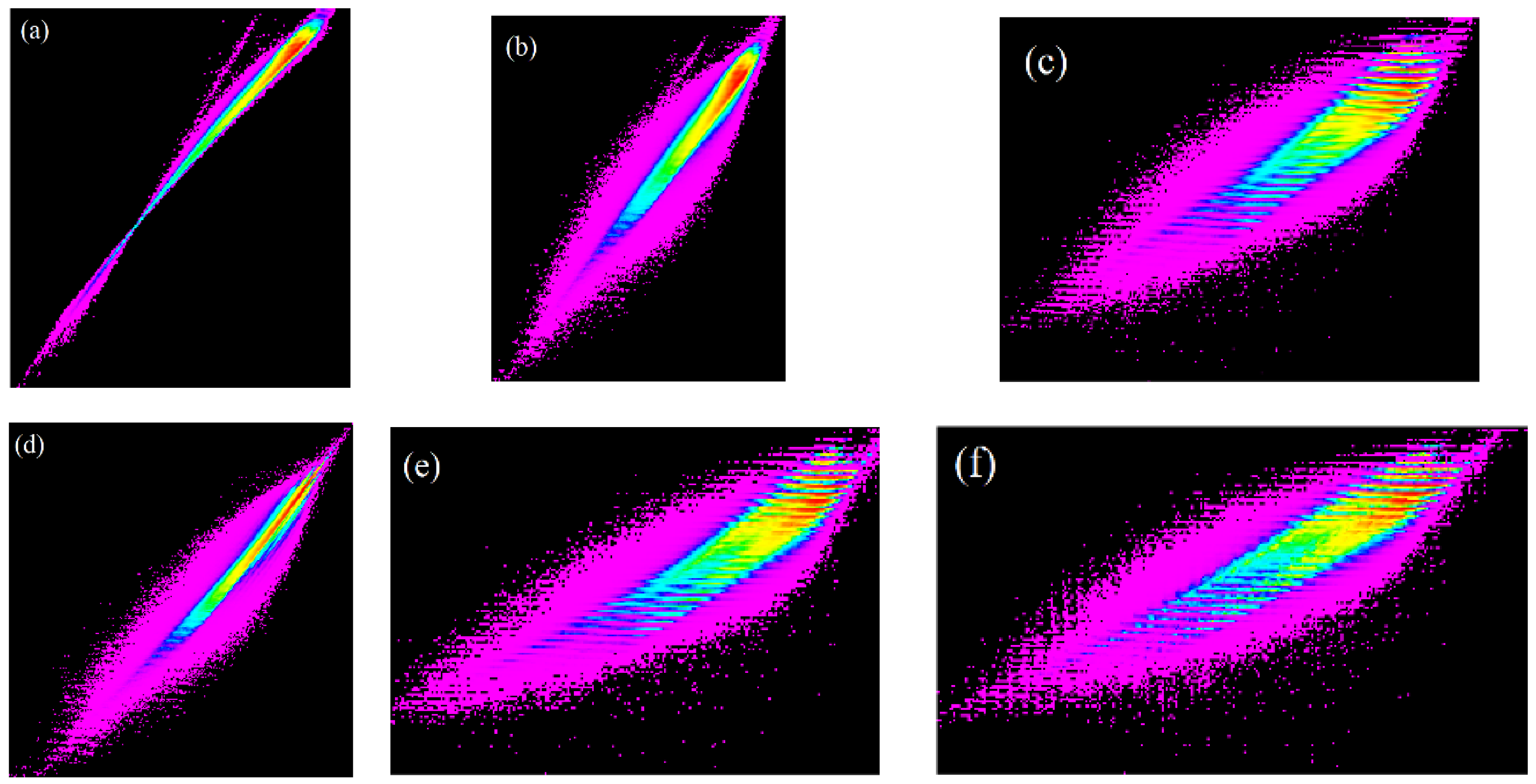
3.7. Comparison of Estimated ET for Selected Land Use/Land Cover

Accuracy of different ET products is affected by many factors including the land use/land cover classes [45]. Based on the National Land Cover Database (NLCD) 2001, cropland (77%) and grassland (11%) are the two dominant land cover classes within the study area. The scatterplot of ET for 5 August 2001 estimated using different ET models for cropland shows that there is some degree of linearity for estimated ET, particularly using METRIC, SEBAL, and SEBS models (Figure 9). It can be seen that there is some variation in the scatterplot involving the SSEBop model (Figure 9c,e,f). To understand the source and reason for this variation, we also plotted the scatterplot for evaporative fraction (Figure 10). There was better linearity in evaporative fraction than daily ET computed using all four models, indicating that these models are effectively capturing the instantaneous ET fluxes and evaporative fraction. Thus, more bias in daily ET while upscaling of instantaneous ET to daily ET is caused mainly by different approaches under different ET models used for upscaling.
Figure 9. Scatterplot of ET on 5 August 2001 estimated using different ET models for cropland showing (a) METRIC model versus SEBAL model; (b) METRIC model versus SEBS model; (c) METRIC model versus SSEBop model; (d) SEBAL model versus SEBS model; (e) SEBAL model versus SSEBop model; and (f) SEBS model versus SSEBop model. Axes values are ET (mm) such as diagonal line will represent 1:1 line. Different colors in the scatterplots indicate density of points with red being the highest density and magenta being the least density.
Water 08 00009 g009
Figure 10. Scatterplot of evaporative fraction estimated for 5 August 2001 using different ET models for cropland showing (a) METRIC model (ETrF) versus SEBAL model (EF); (b) METRIC model (ETrF) versus SEBS model (Λ); (c) METRIC model (ETrF) versus SSEBop model (ETf); (d) SEBAL model (EF) versus SEBS model (Λ); (e) SEBAL model (EF) versus SSEBop model (ETf); and (f) SEBS model (Λ) versus SSEBop model (ETf). Axes values are such as diagonal line represents 1:1 line. Different colors in the scatterplots indicate density of points with red being the highest density and magenta being the least density.
Water 08 00009 g010
Weather data based on automated weather station were used in the METRIC model for computing ETr and for upscaling instantaneous ET to daily ET. Thus, the point-based ETr value is used for the full Landsat image of approximately 170 km north–south by 183 km east–west. Daily average net radiation was used for upscaling instantaneous ET to daily ET for the SEBAL and SEBS model, whereas GDAS-based ETo was used in the SSEBop model for the same purpose. GDAS-based ETo is a spatially explicit raster data generated using the standardized Penman–Monteith equation using six-hourly weather datasets [46]. Different methods of upscaling of instantaneous ET to daily ET has its own bias and variation depending upon seasonality and cloud conditions [42].
Similar to cropland ET, the scatterplot of grassland ET also showed some degree of linearity between the METRIC, SEBAL, and SEBS models (Figure 11). However, scatterplots involving the SSEBop model (Figure 11c,e,f) have different distribution patterns from respective scatterplots for cropland (Figure 9c,e,f). We are unable to explain this difference in distribution pattern here and will investigate this discrepancy further in future research.
Similar to cropland, the linearity was even stronger for evaporative fraction of grassland computed using the METRIC, SEBAL, and SEBS models (Figure 12). The scatterplot of the SSEBop model with the other models for grassland also showed a spread-out distribution for ET but not for evaporative fraction. There was good linearity of evaporative fraction computed from all four models for grassland (Figure 12), which indicates that all four ET models used in this study are capturing the spatial variability of instantaneous ET and evaporative fraction for grassland despite differences in model structure. This is most likely due to use of thermal data as the main driving factor in estimating ET using the energy balance approach. Good performance of the METRIC, SEBAL, SEBS, and SSEBop models for estimating ET in grassland are reported in the literature [22,45,47].
Figure 11. Scatterplot of ET on 5 August 2001 estimated using different ET models for grassland showing (a) METRIC model versus SEBAL model; (b) METRIC model versus SEBS model; (c) METRIC model versus SSEBop model; (d) SEBAL model versus SEBS model; (e) SEBAL model versus SSEBop model; and (f) SEBS model versus SSEBop model. Axes values are ET (mm) such as diagonal line will represent 1:1 line. Different colors in the scatterplots indicate density of points with red being the highest density and magenta being the least density.
Water 08 00009 g011
Figure 12. Scatterplot of evaporative fraction estimated for 5 August 2001 using different ET models for grassland showing (a) METRIC model (ETrF) versus SEBAL model (EF); (b) METRIC model (ETrF) versus SEBS model (Λ), (c) METRIC model (ETrF) versus SSEBop model (ETf); (d) SEBAL model (EF) versus SEBS model (Λ); (e) SEBAL model (EF) versus SSEBop model (ETf); and (f) SEBS model (Λ) versus SSEBop model (ETf). Axes values are such as diagonal line represents 1:1 line. Different colors in the scatterplots indicate density of points with red being the highest density and magenta being the least density.
Water 08 00009 g012

4. Conclusions

Remotely sensed images are increasingly used for quantifying water use at the watershed and larger scale based on different models. Performance of ET models varies depending upon many factors including but not limited to model structure, input data, and user expertise. It is challenging for users to select a particular model from the many that are available to model ET under a given set of circumstances. In this study, four ET models—METRIC, SEBAL, SEBS, and SSEBop—were evaluated using Landsat images over three flux tower sites in the Midwestern United States. Out of three sites, two sites were irrigated maize and one site was dryland maize during 2001.
Though the METRIC, SEBAL, SEBS, and SSEBop models have different degrees of complexity, all four models performed reasonably well in estimating instantaneous ET and evaporative fractions. Even though these four models use different approaches for estimating evaporative fraction, there was some degree of linearity in estimated evaporative fraction. The METRIC model (the most complex among the four tested models) and the SSEBop model (the least complex among the four tested models) resulted in overall comparable performance in estimating ET. Combining data from three flux sites showed that r, R2, RE, MAE, MBE, RMSE, and NSE values were 0.96, 0.92, 8.9%, 22.52%, 8.93%, 0.93 mm, and 0.80, respectively, for the METRIC model; and were 0.96, 0.92, −9.4%, 20.23%, −9.43%, 0.84 mm, and 0.84, respectively, for the SSEBop model. This finding indicates that added complexity does not necessarily lead to improved model performance, as reported by other researchers [28].
While using the SEBAL and SEBS models, users should be careful in upscaling the instantaneous ET to daily ET. Commonly used upscaling approaches based on the empirical equation of daily average net radiation may not work particularly if there is any cloudiness during, before, or after the time of the satellite overpass. In addition, local climatic and atmospheric conditions must be accounted for in any daily average net radiation computation for accurate estimation of daily ET. Under these circumstances, users should either use ground-based daily average net radiation measurements or locally recalibrate Equation (7) using theoretical extraterrestrial solar radiation and standard atmospheric transmissivity for computing daily average net radiation. Our study provides some evidence on the usefulness and limitations of these four ET models for accurate quantification of ET, which can help modelers improve the model and help model users select the right model for estimating ET over agricultural areas.

Acknowledgments

This work was performed under USGS contract G13PC00028 in support of the Department of Interior WaterSMART Program and the Famine Early Warning Systems Network (FEWSNET). The authors thank the AmeriFlux Principal Investigators and their funding organizations for allowing use of their data in our research. We are also thankful to the three anonymous reviewers for their thoughtful comments and suggestions. Any use of trade, firm, or product names is for descriptive purposes only and does not imply endorsement by the U.S. Government.

Author Contributions

R.K.S co-developed the study design, collected the data, coded and ran the models, analyzed the models results, carried out statistical analysis, and wrote the manuscript. G.B.S co-developed the study design, helped with the data analysis and interpretations, and edited several draft of the manuscript.

Conflicts of Interest

The authors declare no conflict of interest.

References

  1. Pereira, L.S.; Allen, R.G.; Smith, M.; Raes, D. Crop evapotranspiration estimation with FAO56: Past and future. Agric. Water Manag. 2015, 147, 4–20. [Google Scholar] [CrossRef]
  2. Allen, R.; Irmak, A.; Trezza, R.; Hendrickx, J.M.H.; Bastiaanssen, W.; Kjaersgaard, J. Satellite-based ET estimation in agriculture using SEBAL and METRIC. Hydrol. Process. 2011, 25, 4011–4027. [Google Scholar] [CrossRef]
  3. Yan, H.; Wang, S.Q.; Billesbach, D.; Oechel, W.; Bohrer, G.; Meyers, T.; Martin, T.A.; Matamala, R.; Phillips, R.P.; Rahman, F.; et al. Improved global simulations of gross primary product based on a new definition of water stress factor and a separate treatment of C3 and C4 plants. Ecol. Model. 2015, 297, 42–59. [Google Scholar] [CrossRef]
  4. Vicente-Serrano, S.M.; Camarero, J.J.; Zabalza, J.; Sanguesa-Barreda, G.; Lopez-Moreno, J.I.; Tague, C.L. Evapotranspiration deficit controls net primary production and growth of silver fir: Implications for Circum-Mediterranean forests under forecasted warmer and drier conditions. Agric. For. Meteorol. 2015, 206, 45–54. [Google Scholar] [CrossRef]
  5. Karlsson, I.B.; Sonnenborg, T.O.; Seaby, L.P.; Jensen, K.H.; Refsgaard, J.C. Effect of a high-end CO2-emission scenario on hydrology. Clim. Res. 2015, 64, 39–54. [Google Scholar] [CrossRef]
  6. Anderson, M.C.; hain, C.; Otkin, J.; Zhan, X.; Mo, K.; Svoboda, M.; Wardlow, B.; Pimstein, A. An intercomparison of drought indicators based on thermal remote sensing and NLDAS-2 simulations with U.S. drought monitor classifications. J. Hydrometeorol. 2013, 14, 1035–1056. [Google Scholar] [CrossRef]
  7. Yimam, Y.T.; Ochsner, T.E.; Kakani, V.G. Evapotranspiration partitioning and water use efficiency of switchgrass and biomass sorghum managed for biofuel. Agric. Water Manag. 2015, 155, 40–47. [Google Scholar] [CrossRef]
  8. Spies, R.R.; Franz, K.J.; Hogue, T.S.; Bowman, A.L. Distributed hydrologic modeling using satellite-derived potential evapotranspiration. J. Hydrometeorol. 2015, 16, 129–146. [Google Scholar] [CrossRef]
  9. Snyder, R.L.; Pedras, C.; Montazar, A.; Henry, J.M.; Ackley, D. Advances in ET-based landscape irrigation management. Agric. Water Manag. 2015, 147, 187–197. [Google Scholar] [CrossRef]
  10. Nolan, R.H.; Lane, P.N.J.; Benyon, R.G.; Bradstock, R.A.; Mitchell, P.J. Trends in evapotranspiration and streamflow following wildfire in resprouting eucalypt forests. J. Hydrol. 2015, 524, 614–624. [Google Scholar] [CrossRef]
  11. Bastiaanssen, W.G.M.; Karimi, P.; Rebelo, L.M.; Duan, Z.; Senay, G.; Muthuwatte, L.; Smakhtin, V. Earth observation based assessment of the water production and water consumption of Nile Basin agro-ecosystems. Remote Sens. 2014, 6, 10306–10334. [Google Scholar] [CrossRef]
  12. Gowda, P.H.; Chavez, J.L.; Colaizzi, P.D.; Evett, S.R.; Howell, T.A.; Tolk, J.A. ET mapping for agricultural water management: Present status and challenges. Irrig. Sci. 2008, 26, 223–237. [Google Scholar] [CrossRef]
  13. Glenn, E.P.; Nagler, P.L.; Huete, A.R. Vegetation Index Methods for estimating evapotranspiration by remote sensing. Surv. Geophys. 2010, 31, 531–555. [Google Scholar] [CrossRef]
  14. Kalma, J.D.; McVicar, T.R.; McCabe, M.F. Estimating land surface evaporation: A review of methods using remotely sensed surface temperature data. Surv. Geophys. 2008, 29, 421–469. [Google Scholar] [CrossRef]
  15. Bastiaanssen, W.G.M. Regionalization of Surface Flux Densities and Moisture Indicators in Composite Terrain: A Remote Sensing Approach under Clear Skies in Mediterranean Climates; Report 109; DLO The Winand Staring Centre: Wageningen, The Netherlands, 1995. [Google Scholar]
  16. Bastiaanssen, W.G.M.; Menenti, M.; Feddes, R.A.; Holtslag, A.A.M. A remote sensing surface energy balance algorithm for land (SEBAL)—1. Formulation. J. Hydrol. 1998, 212, 198–212. [Google Scholar] [CrossRef]
  17. Su, Z. The Surface Energy Balance System (SEBS) for estimation of turbulent heat fluxes. Hydrol. Earth Syst. Sci. 2002, 6, 85–99. [Google Scholar] [CrossRef]
  18. Allen, R.G.; Tasumi, M.; Trezza, R. Satellite-based energy balance for mapping evapotranspiration with internalized calibration (METRIC)—Model. J. Irrig. Drain. Eng. 2007, 133, 380–394. [Google Scholar] [CrossRef]
  19. Senay, G.B.; Bohms, S.; Singh, R.K.; Gowda, P.H.; Velpuri, N.M.; Alemu, H.; Verdin, J.P. Operational evapotranspiration mapping using remote sensing and weather datasets: A new parameterization for the SSEB approach. J. Am. Water Resour. Assoc. 2013, 49, 577–591. [Google Scholar] [CrossRef]
  20. Singh, R.; Senay, G.; Velpuri, N.; Bohms, S.; Scott, R.; Verdin, J. Actual evapotranspiration (water use) assessment of the Colorado River Basin at the Landsat resolution using the Operational Simplified Surface Energy Balance Model. Remote Sens. 2013, 6, 233–256. [Google Scholar] [CrossRef]
  21. Bastiaanssen, W.G.M.; Noordman, E.J.M.; Pelgrum, H.; Davids, G.; Thoreson, B.P.; Allen, R.G. SEBAL model with remotely sensed data to improve water-resources management under actual field conditions. J. Irrig. Drain. Eng. 2005, 131, 85–93. [Google Scholar] [CrossRef]
  22. Ershadi, A.; McCabe, M.F.; Evans, J.P.; Chaney, N.W.; Wood, E.F. Multi-site evaluation of terrestrial evaporation models using FLUXNET data. Agric. For. Meteorol. 2014, 187, 46–61. [Google Scholar] [CrossRef]
  23. French, A.N.; Hunsaker, D.J.; Thorp, K.R. Remote sensing of evapotranspiration over cotton using the TSEB and METRIC energy balance models. Remote Sens. Environ. 2015, 158, 281–294. [Google Scholar] [CrossRef]
  24. Irmak, S.; Istanbulluoglu, E.; Irmak, A. An evaluation of evapotranspiration model complexity against performance in comparison with Bowen ratio energy balance measurements. Trans. ASABE 2008, 51, 1295–1310. [Google Scholar] [CrossRef]
  25. Li, S.; Zhang, L.; Kang, S.; Tong, L.; Du, T.; Hao, X.; Zhao, P. Comparison of several surface resistance models for estimating crop evapotranspiration over the entire growing season in arid regions. Agric. For. Meteorol. 2015, 208, 1–15. [Google Scholar] [CrossRef]
  26. Lu, J.; Sun, G.; McNulty, S.G.; Amatya, D.M. A comparison of six potential evapotranspiration methods for regional use in the southeastern United States. J. Am. Water Resour. Assoc. 2005, 41, 621–633. [Google Scholar] [CrossRef]
  27. Gonzalez-Dugo, M.P.; Neale, C.M.U.; Mateos, L.; Kustas, W.P.; Prueger, J.H.; Anderson, M.C.; Li, F. A comparison of operational remote sensing-based models for estimating crop evapotranspiration. Agric. For. Meteorol. 2009, 149, 1843–1853. [Google Scholar] [CrossRef]
  28. Orth, R.; Staudinger, M.; Seneviratne, S.I.; Seibert, J.; Zappa, M. Does model performance improve with complexity? A case study with three hydrological models. J. Hydrol. 2015, 523, 147–159. [Google Scholar] [CrossRef]
  29. El Tahir, M.E.H.; Wenzhong, W.; Xu, C.Y.; Youjing, Z.; Singh, V.P. Comparison of methods for estimation of regional actual evapotranspiration in data scarce regions: Blue Nile Region, Eastern Sudan. J. Hydrol. Eng. 2012, 17, 578–589. [Google Scholar] [CrossRef]
  30. Wilson, K.B.; Hanson, P.J.; Mulholland, P.J.; Baldocchi, D.D.; Wullschleger, S.D. A comparison of methods for determining forest evapotranspiration and its components: Sap-flow, soil water budget, eddy covariance and catchment water balance. Agric. For. Meteorol. 2001, 106, 153–168. [Google Scholar] [CrossRef]
  31. Consoli, S.; Vanella, D. Comparisons of satellite-based models for estimating evapotranspiration fluxes. J. Hydrol. 2014, 513, 475–489. [Google Scholar] [CrossRef]
  32. Chen, Y.; Xia, J.; Liang, S.; Feng, J.; Fisher, J.B.; Li, X.; Li, X.; Liu, S.; Ma, Z.; Miyata, A.; et al. Comparison of satellite-based evapotranspiration models over terrestrial ecosystems in China. Remote Sens. Environ. 2014, 140, 279–293. [Google Scholar] [CrossRef]
  33. Verma, S.B.; Dobermann, A.; Cassman, K.G.; Walters, D.T.; Knops, J.M.; Arkebauer, T.J.; Suyker, A.E.; Burba, G.G.; Amos, B.; Yang, H.; et al. Annual carbon dioxide exchange in irrigated and rainfed maize-based agroecosystems. Agric. For. Meteorol. 2005, 131, 77–96. [Google Scholar] [CrossRef]
  34. Su, H.; McCabe, M.F.; Wood, E.F.; Su, Z.; Prueger, J.H. Modeling evapotranspiration during SMACEX: Comparing two approaches for local- and regional-scale prediction. J. Hydrometeorol. 2005, 6, 910–922. [Google Scholar] [CrossRef]
  35. Foken, T.; Aubinet, M.; Finnigan, J.J.; Leclerc, M.Y.; Mauder, M.; Paw, U.K.T. Results of a panel discussion about the energy balance closure correction for trace gases. Bull. Am. Meteorol. Soc. 2011, 92. [Google Scholar] [CrossRef]
  36. Singh, R.K.; Irmak, A. Treatment of anchor pixels in the METRIC model for improved estimation of sensible and latent heat fluxes. Hydrol. Sci. J. 2011, 56, 895–906. [Google Scholar] [CrossRef]
  37. Long, D.; Singh, V.P. Assessing the impact of end-member selection on the accuracy of satellite-based spatial variability models for actual evapotranspiration estimation. Water Resour. Res. 2013, 49, 2601–2618. [Google Scholar] [CrossRef]
  38. Paul, G.; Gowda, P.H.; Vara Prasad, P.V.; Howell, T.A.; Staggenborg, S.A.; Neale, C.M.U. Lysimetric evaluation of SEBAL using high resolution airborne imagery from BEAREX08. Adv. Water Resour. 2013, 59, 157–168. [Google Scholar] [CrossRef]
  39. Mahour, M.; Stein, A.; Sharifi, A.; Tolpekin, V. Integrating super resolution mapping and SEBS modeling for evapotranspiration mapping at the field scale. Precis. Agric. 2015, 16, 571–586. [Google Scholar] [CrossRef]
  40. Chavez, J.L.; Neale, C.M.U.; Prueger, J.H.; Kustas, W.P. Daily evapotranspiration estimates from extrapolating instantaneous airborne remote sensing ET values. Irrig. Sci. 2008, 27, 67–83. [Google Scholar] [CrossRef]
  41. Colaizzi, P.D.; Evett, S.R.; Howell, T.; Tolk, J.A. Comparison of five models to scale daily evapotranspiration from one-time-of-day measurements. Trans. Am. Soc. Agric. Eng. 2006, 49, 1409–1419. [Google Scholar] [CrossRef]
  42. Cammalleri, C.; Anderson, M.C.; Kustas, W.P. Upscaling of evapotranspiration fluxes from instantaneous to daytime scales for thermal remote sensing applications. Hydrol. Earth Syst. Sci. 2014, 18, 1885–1894. [Google Scholar] [CrossRef] [Green Version]
  43. Zhang, X.C.; Wu, J.W.; Wu, H.Y.; Chen, H.R.; Zhang, T. Improving temporal extrapolation for daily evapotranspiration using radiation measurements. J. Appl. Remote Sens. 2013, 7. [Google Scholar] [CrossRef]
  44. Timmermans, J.; Su, Z.; van der Tol, C.; Verhoef, A.; Verhoef, W. Quantifying the uncertainty in estimates of surface-atmosphere fluxes through joint evaluation of the SEBS and SCOPE models. Hydrol. Earth Syst. Sci. 2013, 17, 1561–1573. [Google Scholar] [CrossRef]
  45. Velpuri, N.M.; Senay, G.B.; Singh, R.K.; Bohms, S.; Verdin, J.P. A comprehensive evaluation of two MODIS evapotranspiration products over the conterminous United States: Using point and gridded FLUXNET and water balance ET. Remote Sens. Environ. 2013, 139, 35–49. [Google Scholar] [CrossRef]
  46. Senay, G.B.; Verdin, J.P.; Lietzow, R.; Melesse, A.M. Global daily reference evapotranspiration modeling and evaluation. J. Am. Water Resour. Assoc. 2008, 44, 969–979. [Google Scholar] [CrossRef]
  47. Timmermans, W.J.; Kustas, W.P.; Anderson, M.C.; French, A.N. An intercomparison of the surface energy balance algorithm for land (SEBAL) and the two-source energy balance (TSEB) modeling schemes. Remote Sens. Environ. 2007, 108, 369–384. [Google Scholar] [CrossRef]

