
Water Information as a Tool to Enhance Sustainable Water Management—The Australian Experience

The Australian National University, Canberra ACT, 2600, Australia
Water 2015, 7(5), 2161-2183; https://doi.org/10.3390/w7052161
Submission received: 25 February 2015
/
Revised: 8 April 2015
/
Accepted: 4 May 2015
/
Published: 12 May 2015
Abstract
:Many countries and regions have struggled to put in place adequate water information systems to assist with sustainable water management. This article describes and assesses the key components of Australia’s water information and data systems, with particular reference to rural and regional Australia, focusing on progress with strengthening these systems at a national level since 2007. Through the early part of the period, much of Australia was experiencing a crisis in water availability. The article concludes with ongoing challenges for Australia and lessons from the Australian experience for other countries embarking on upgrading their water information and data systems. Upgrading a nation’s water information systems is a long-term task, but an important one in a world of climate change and increased climate variability. Substantial progress is likely to take five to 10 years to materialize. From the outset, upgrading information systems needs to be focused on data series that will facilitate answering key policy questions, assist water users in making significant decisions more effectively, and allow businesses and government to better address risks from water-related events. As always, political support matters. To sustain investments in information, its coverage must facilitate illuminating key questions and issues. Custodians of information systems must ensure that the value proposition is clear to all.
1. Introduction
Over the past decade there has been a massive upsurge in interest in water management regimes on every continent [1,2].
Managing our water resources effectively requires appropriate information across many areas, in part depending on the use of the water resource, the role of water markets in determining or regulating allocation decisions, the priority accorded the environment, and the governance arrangements in place. Demand for better, quality-assured information also comes from a myriad of users covering water market participants, resource managers and operators, regulators, policy makers, and analysts. Many countries and regions have struggled to put in place adequate water information systems [3,4,5,6,7].
The collection, dissemination, quality, and transparency (both in reporting and analysis) of water information and data are not ends in themselves. In the face of increasing water scarcity and value in some areas, and an increasing incidence of floods in others, adequate information is critical to understanding the essence of the “water problem”. It should assist to provide a firm foundation for crafting solutions, or understanding progress towards outcomes sought. It assists water managers (be they businesses, households, or environmental water managers) to optimize their use of water, as well as businesses that are involved in assessing or managing risks related to water resources. Overall, there is a strong public good element in funding good basic information covering our water resources and markets.
It goes to ensuring we:
- Use our resources as we intend—in mining and agriculture, and increasingly the environment—in a transparent way, and that we make important decisions about resource use with the benefit of basic knowledge and information, not solely on the basis of “if a problem emerges we will handle it then”.
- Manage risks to the environment purposefully in developing our resources and industries. If we intend to manage the environment in line with “sustainability benchmarks” we should be able to articulate what this means, and ought to be able to track outcomes to ensure we are achieving them.
- Invest our scarce public sector resources (for example, in both hard and soft infrastructure) wisely, understanding and making transparent the implications of our decisions.
However, there will always be a legitimate and important discussion concerning how much information is needed to respond to user demands for water information. Do existing data collections and underlying science facilitate policymaking, allow testing of compliance regimes, or help to establish accountability? Do existing information collections facilitate economic decisions by industries, farmers, and irrigators, or facilitate assessment of the sustainability of ecosystem services? Is the existing state of understanding of our water resources likely to change with the application of new information technology, or does new technology allow data collection that was hitherto impossible? In a rapidly changing economy and society, is the available information adequate to answer key questions of users in an enduring fashion? An ongoing task is to ensure the relevance and cost-effectiveness of data collection, and at the same time not allow collection and dissemination to be stymied by vested interests, or groups that may be adversely affected by the availability of transparent information. Information will not replace the role society and governments play in determining future boundaries on water use, but it will go a long way toward ensuring that decisions are taken with “eyes open”.
In this article, Section 2 describes the key components of Australia’s water information and data collections with particular reference to rural and regional Australia, focusing on national efforts to strengthen these collections since 2007. Section 3 assesses the progress in strengthening the Australian water information system (as of the end of 2014), and the concerns that continue to exist. Section 4 outlines the ongoing challenges for Australia and the lessons from the Australian experience for other countries embarking on upgrading their water information and data systems. The assessment is qualitative, and the judgments drawn based on the referenced literature and the author’s direct involvement as a senior national policy advisor.
2. Key Components of Australia’s Water Information System
A country’s water information system will at least in part reflect the roles and responsibilities set out in its legislative and institutional framework. In Australia’s case, state governments have historically played a key role in managing its water resources, in the context of a federal system. State water agencies continue to collect and disseminate much local level water information, including important information in regards to annual water allocations to holders of water entitlements.
However, over the past two decades this role has changed significantly, with the national government and national agencies playing an increasingly important role. The need for improved water information in Australia was acknowledged at some length in its 2004 National Water Initiative (NWI), an overarching national intergovernmental water-planning document. The NWI set out the importance of additional knowledge and information, and where extra work was required to assist in delivering improved management outcomes [3,8,9]. At that time, the national government provided substantial resources to improve “water management, capacity, knowledge, skills and innovation.” Initiatives included development of a nationally compatible water accounting system, a suite of groundwater projects, a national hydrological modeling tool, the CSIRO sustainable yields project (at the direct behest of the national government), and established national data sets for commencing monitoring and reporting of water markets [10,11]. This program commenced operation in June 2006. Issues with data collections were also raised but not immediately progressed [12,13].
Focused holistic attention ensuring the adequacy of water information commenced in late 2006, as a part of preparatory work for the 2007 national government’s National Plan for Water Security. This 10-year plan sought “to improve water efficiency and address overallocation of water in rural Australia,” from which some 70% of Australian consumption emanates. A catchphrase of the January 2007 announcement was “You can’t manage what you don’t measure” [14].
The major driver for this new holistic approach to establish an appropriate and effective national water information system was the Commonwealth Water Act of 2007. It was passed with bipartisan support in the national parliament at a time of crisis in water availability. The Act reflected a widely-held view that state-based information systems were not delivering an effective platform for decision-making. It provided the authority to certain national agencies (particularly the Australian Bureau of Meteorology (BOM), the Murray Darling Basin Authority (MDBA), and the Australian Competition and Consumer Commission (ACCC)) to compel the provision of certain types of information from designated bodies. In practice, national institutions sought to gather information in a cooperative, transparent framework, but the mandatory powers conferred through legislation and regulation provided the teeth to ensure good compliance. Agencies sought to implement their new responsibilities cooperatively, focusing on the value proposition that improved information will facilitate enhanced economic and environmental outcomes, and a need to change the culture to one that was more open and transparent.
Prior to 2007, the Australian Bureau of Statistics (ABS) had published its Water Account Australia on two occasions (2000–2001 and 2004–2005) and Water Use on Australian Farms (from its Agricultural Survey, taken annually since 2002–2003) [15,16,17]. Overall, these series were less than satisfactory, being unable to answer most key questions of policy makers, river operators, and businesses, particularly irrigators. Bodies at the local or state level collected water information for local purposes, but it was far from transparent and consistent, was often not comparable state to state or basin to basin, and, as documented in the NWI and elsewhere, left much to be desired [9,18].
2.1. Water Information Services
A key part of the national government’s 2007 National Plan for Water Security (later rebranded as “Water for the Future”) was announced as a A$480 million 10-year program to provide consistent, improved water services for all users [14]. This included large investments in modernizing state based streamflow, groundwater, and storage monitoring systems, and the automation and standardization of data collection [7,19]. Coupled with the work already in the pipeline, the new water information program was the central vehicle for building a new fit for purpose water information framework. The concept of “fit for purpose” information was well recognized. Information needed to facilitate national (or basin-wide, interjurisdictional) and state-based policymaking, and decision-making at the local level by farmers and irrigators. It also needed to provide more timely and accurate information to businesses in general. Historical issues of inconsistent standards and measurement needed to be rectified, access to all users improved, and levels of transparency increased dramatically [3]. The driver for the national government’s intentions was the Water Act 2007.
The overall national water information program would be implemented in large part by BOM [19] building on and in collaboration with state agencies. Other institutions that played important supporting roles included the ABS, the competition policy regulator (the Australian Competition and Consumer Commission (ACCC), the Murray Darling Basin Authority (MDBA), and the National Water Commission (NWC). A myriad of state agencies and state or regional water service providers that had previously collected information for their own purposes would now provide existing information streams to the BOM.
The national Water Regulations of 2008 prescribed the water data to be provided to the BOM, pursuant to the provisions of the Water Act 2007. They list the parties from whom the BOM would gather data sets, limited to existing information held in electronic form. Additionally, the Regulations require organizations to give metadata and contextual information about water information. The regulations specify the information particular organizations must provide the BOM. They also specify the terms under which this information passes to the central repository, to minimize transaction costs. Aspects of this new program included making local or state level data available on a national basis, bringing to bear much more rigorous standards for collection to ensure consistency and comparability, and supplementing this data with new information series to allow analysis of issues that had been neglected. Some of this would require development of new tools, better collection infrastructure, or better application and development of technology and scientific analysis.
The information covered by the national Water Regulations includes:
- surface water resource information (level and flow of surface water in watercourses, excluding water storages) (category 1);
- ground water resource information (level and pressure of groundwater and aquifer recharge volumes) (category 2);
- water storage information (water storage level, volume, inflows and outflows, and the location, capacity, and ownership of major storages) (category 3);
- meteorological information (meteorological phenomena that affect the availability of water. Includes: rainfall, wind speed, humidity, evaporation, temperature, pressure, vapor pressure deficit, and solar exposure and irradiance) (category 4);
- water use information (water takes, supplies, and returns) (category 5), and information about water rights, allocations, and trades (water access rights, irrigation rights, water trades, water allocation announcements, and permits) (category 6);
- information about urban water management (urban water resources and management. Includes information on water takes, supplies, sewage, urban stormwater, and recycled water (category 7), and information about water restrictions (announcements of water use restrictions) (category 8);
- water quality information (electrical conductivity, suspended solids, turbidity, nutrient content, acidity, and temperature of surface water. Includes electrical conductivity and acidity of ground water) (category 9); and
- water information for flood warning purposes (level and flow of surface water in watercourses, and rainfall information used for flood warning purposes) (category 11) [20].
Vertessy noted that these new services needed to be “enduring, repeatable, robust, trusted and tailored to end user need” [7].
Before much of this work could yield direct benefits to users, detailed preparatory work was required—for example, agreeing standards, building information systems, and ensuring data sets would assist answering key questions. The Australian Water Resources Information System (AWRIS) was to be the vehicle to underpin many of the BOM’s water information products and services, get data suppliers on board, and develop ways to minimize transaction costs [19]. AWRIS was to be a powerful information system capable of receiving, standardizing, organizing, and interpreting water data from across the nation [21]. As with many novel IT systems, serious implementation issues arose, delaying the delivery of some new products and services [18]. However, an initial implementation of AWRIS (known as AWRIS 1) was completed, with the BOM making important new “value adding” products available to users by alternative means (for example, Water Data Online [22] provides access to surface water data in a way not seen previously in state-based portals). Direct access to data is currently more limited than originally envisaged [18,19].
AWRIS 2 is scheduled to be operational in 2015, with the ambition that it will be more capable and more independently searchable, which will assist delivery of water information to users more in line with what was originally expected. The original capability sought for AWRIS was the access it would give to all users to independently tap into a national, compatible, reliable, independent, and searchable database, dramatically improving transparency. This is still the objective, but its potential to enhance decision-making and monitoring is yet to be fully realized.
The BOM is now publishing much of the “progress thus far” through its website, including new dashboards and forecasting services. Nearly all the published or searchable products involve intensive collaboration with state and territory governments, water service providers, and other Commonwealth agencies. In the context of water regulation information categories presented above, key areas of progress include:
- Development of the Australian Hydrological Geospatial Fabric (Geofabric)–enabling a detailed understanding of how water is “stored, transported and used through the landscape,” and is being used in water accounting, assessment, forecasting, and prediction [25].
- Groundwater—a suite of groundwater-specific products is available, allowing access to data at 800,000 bore locations, and includes a Groundwater Dependent Ecosystems Atlas. Groundwater information is included in the Geofabric, Australian Water Resources Assessment and the National Water Account (categories 2, 5, and 6).
- Modernization and extension of hydrologic monitoring systems of state agencies and water service providers resulting in improved measurements and data management systems, enabling higher quality and more standardized national reporting across many information categories [26].
- Water Data Online—bringing together nationally consistent water information at a local level (category 1) [22].
- Australian Water Resource Assessments—provides a national-scale assessment structured around 13 regions, answering questions about water availability (categories 1, 2, 3, 5, 7, and 9) [19].
- Standards—significant progress. Version 1.2 of the Water Data Transfer Format available and Australian Water Accounting Standard 2 released [28].
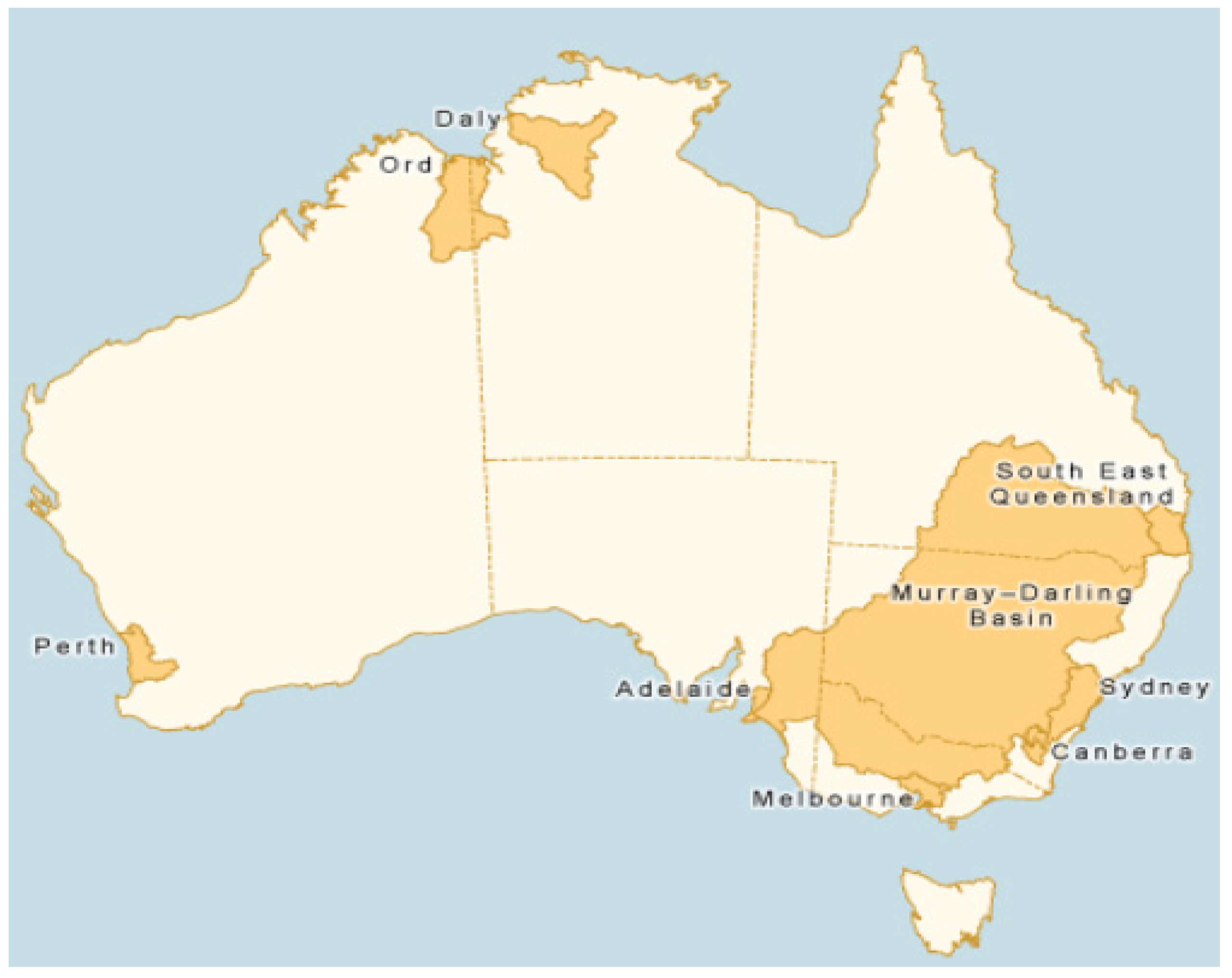
- The National Water Account—the release provides an annual report on the significant water regions in Australia encompassing the capital cities and their hinterlands, and the MDB, Ord, and Daly systems [29]. As can be seen from Figure 1 below, while the report only covers a small proportion of the Australian continent, it covers well over 70% of the population and 70%–80% of national water consumption (depending on the year). Its limited area of coverage underscores the focus on cost effectiveness, as the regional accounts contained detailed line items on assets, liabilities, and flows of water (categories 1, 5, 6, and 7).
A key feature of the information series produced by national bodies is the routine use of the “Creative Commons” data licensing approach. This “open data” approach is in contrast to previous state-based approaches. It greatly simplifies access to the information and inter alia allows development of apps and other products by third parties to enhance the utilization of water information in decision-making. At this point some state governments have not adopted fully this transparent approach. Some agencies still require special permissions for access to, for example, underlying water modeling. In a real sense, an open national approach to information can provide much enhanced access information by all information users.
The above progress by the BOM amounts to a massive step forward in terms of information availability and transparency compared with a decade ago. However, the job is not complete. Areas where less or little progress has been achieved include water quality and water prices, and some remaining definitional issues in key data series between national and state agencies, and even between national agencies. These issues are discussed below.
Figure 1.
Coverage of National Water Account, 2013. Source: [29].
Figure 1.
Coverage of National Water Account, 2013. Source: [29].

The BOM’s water information program is not only about improving data collection and availability to users but importantly focuses on developing new tools for water users. For example, under a joint program between the BOM and Australia’s preeminent science organization, the CSIRO, under the Water Information Research and Development Alliance (WIRADA) framework, tools have been developed that allow enhanced stream flow forecasting, new data standards, and more transparent, detailed, and reliable water availability modeling in many key areas [30]. While the suite of available services continues to evolve, there is little doubt that significant improvements have been made in data availability and its timing, answering many key questions of water information users [19]. For example, data on water storages, streamflow, and groundwater conditions are now transparent, and provide much improved quality, timeliness, and comparability. The data are not yet searchable in complex ways [18], but it is intended that this function be added in the context of completion of AWRIS 2 in 2015. This “searchable” functionality will allow many water information users further opportunities to add value.
Observation points underpinning streamflow forecasting have increased significantly following a major BOM-led investment program and, when combined with new tools, enabled “improved forecasting of inflows into reservoirs and management of environmental water reserves and provided valuable preparation for flood forecasting” ([19], p. 2). Geoscience Australia (GA) continues to develop its path-breaking “data cube” technology, which will substantially aid managing flood risk [31], and in time may be able to address other large risks to water resource sustainability, such as the expansion of farm dams in the MDB.
Of course, much of this can only take place because of recent developments in information technology, and the assistance from a large number of collection agencies making this information widely and transparently available. This has been part of what has been a central problem in the implementation and development of the water information system.
Two large projects—the AWRIS project noted above, and a project to bring together all state water registries to enable users to maximize benefits from water markets that cross state boundaries—involved large information technology elements. Both these projects have had serious delivery problems. In the case of the AWRIS, the BOM was initially forced to reduce the scope of the project in the short term as data management issues proved insurmountable, significantly affecting its initial value to users [18]. In the case of the second, the project has been terminated [32]. It remains to be seen if key aspects relating to accurate and timely price and quantity data will be completed.
Some users and data collectors (mainly water service providers and state-based regulators) have not so warmly supported the increased attention from the broadly based information program. Some of the submissions to the review of the Water Act 2007, from state governments, irrigation companies, and shire councils provide evidence of this attitude [33]. In bureaucratic politics terms, the move to improve the quality, transparency, and usability of data collections is viewed as a threat. In these submissions, there is a tendency to omit mention of what is useful, forget the service that was being provided a decade ago, and largely ignore the type of service users demand today, where online access is seen as a minimum starting point. However, there is a valid point being made: a lesson from these submissions is that it is essential that the benefits and costs of enhanced data collection, and information that is subsequently made freely and publicly available, be carefully assessed. It is also important to increase awareness of the progress being made, and what can be achieved relative to what could previously be achieved. Good design of collection methods is an important part of keeping costs low.
2.2. Economic Information
2.2.1. Australian Bureau of Statistics Data
The ABS began producing (irregularly) its “Water Account, Australia” (WAA), in accordance with the System of Environmental-Economic Accounting. The ABS notes WAA presents information on the physical and monetary supply and use of water in the Australian economy [17]. Data covering agricultural water use were largely collected through periodic censuses and more regular surveys directed at farmers and irrigators [15], but there are significant questions relating to its adequacy in a contemporary water management framework. The ABS has not delved much into water prices, trading, or environmental water use, all key economic questions.
Much of the discussion on water information when the NWI was being negotiated in 2003–2004, and later in late 2006 prior to the announcement of the National Plan for Water Security, recognized that the data collected and the method of collection by the ABS were unable to address many of the key policy questions being discussed in the Australian water sector. The data series for water use on farms, largely based on an Agricultural Survey/Census, was not adequate to examine issues around scarcity, sustainability, quality, and value that were at the forefront of the NWI in rural and regional Australia. Its concept of “use” is on the one hand narrow (for example, not engaging with how much conveyance water was required to underwrite on-farm use) and from an irrigator/policymaker perspective unusual (attributing large volumes of “use” to hydroelectric power generation when the net water lost to the system from this activity was small). It was difficult for many water information users to engage with. The ABS sought to examine “physical water supply and use” and “monetary water supply and use” but (at least in part reflecting limited resourcing and the decision to widen the BOM’s water information remit) key technical water resource issues were not engaged with. The “Water Account Australia” helps us to start addressing questions around urban water use in Australia, and useful research continues on valuation of water resources [34]. However, by design it was left to BOM and others to develop accessible products that enabled information to be readily accessed. BOM, CSIRO, and GA focused on the issues, skillsets, and technology needed to address mainstream water policy and user questions.
One of the weaknesses of the ABS data a decade ago (and it remains) was that the environment was not recognized as a “water user”, and none of the water data looked at water quality or sustainability issues. Moreover, issues around farm dams, groundwater use, water required to deliver water consumed on farms, and return flows all detracted from the published data set. For example, understanding the change in return flows over time will assist in accurately understanding the benefits and costs of on-farm infrastructure subsidy programs to bolster environmental flows. The issues with the ABS data in part reflect the collection methodology (built around the national farm census and periodic surveys), and the fact that the original data collection did not have the environment as a focus of attention or need. It underscores the need for data collections to be reassessed periodically to respond to need. Estimates addressing some of these issues are now available. These estimates have been produced from work originally commissioned by the former National Water Commission and now overseen by the BOM, through the BOM’s developing AWRIS framework and through information collected by the ACCC. In the future, drawing together new technologies (see below) seems likely to enable more effective management of ground and surface water resources, including getting a much more accurate grasp of the risks involved in managing resources.
2.2.2. Water Market Data
Water markets play an important role in ensuring that available water is used productively in some important areas of rural Australia. An important new player in these markets, particularly in the MDB, is the ACCC, which took on new regulatory functions under the Water Act of 2007 and the Competition and Consumer Act of 2010 [35]. Its Water Monitoring Report outlines progress on many of the economic reforms being pursued in the rural water markets, covering regulated water charges, water entitlement transformation, and compliance with water charge rules and water market rules [36]. This has greatly increased transparency of interjurisdictional water management across the MDB.
For example, the ACCC now publishes, inter alia, data on the extent of transformation of water rights by water entitlement holders (and the time taken by irrigation infrastructure operators (IIOs) to undertake this task), the impact of old and new restrictions on trade imposed by state governments, the adherence to water charging rules by IIOs (measuring the number of cases and seriousness of overcharging by IIOs), and the levels of water planning and management charges of state authorities. This information has increased the level of transparency around water trading rules and behavior of irrigation infrastructure operators (IIOs), and of itself places ongoing pressure on them and state authorities to behave appropriately. The data also makes transparent to irrigators how their IIO operates compared with other IIOs. For example, in 2012–2013, the data illustrate how the size of the “casual (water) user fee” significantly affects the volume of water delivered on a casual basis [37]. For more background see [3,38].
A “National Water Market System” was to be a cornerstone of data provision on both quantity and price for Australia’s water markets. However, as with many information technology projects, resistance to change from state agencies and lack of commitment at the national level led to this project being abandoned, and future of the progress made uncertain [39,40].
As a result, an ongoing substantial weakness in Australian water information on water trading continues to be the absence of accurate (full price disclosure) and timely (better than weekly) price data, organized in a manner useful to market participants (through a single portal). At one level, it is surprising that comprehensive availability and transparency of water price data has not improved dramatically as water markets from allocation water and entitlement water in the MDB in particular have grown. All the necessary data are capable of being collected within existing state-based administrative frameworks when individual transactions are registered. Such an information service would be a major plus for all participants in the water markets, from irrigators to investors and brokers, and environmental water holders that are permitted to trade. The water trading rules of the Basin Plan, which commenced mid-2014, require states to publish trading prices.
2.3. Importance of Basic Science and Technology to Water Information
A series of one-off projects since 2007 has considerably enhanced Australia’s basic understanding of its water resources. Three such projects are outlined below to illustrate the role of basic science and new analytical tools to the water information system; the role of independent expert science agencies undertaking the work; and the importance of this work being undertaken at a basin level, putting aside state-based political and other interjurisdictional issues.
2.3.1. CSIRO “Sustainable Yields” Study
In November 2006, in the face of rapidly worsening water availability in parts of the Murray Darling Basin (MDB), the Australian government commissioned the CSIRO to undertake a long-term comprehensive assessment of water availability in the MDB. CSIRO was the preeminent [41], independent national research organization and the only organization at the time capable of undertaking basin-wide research with the support of the governments of the four states and one territory involved in the MDB.
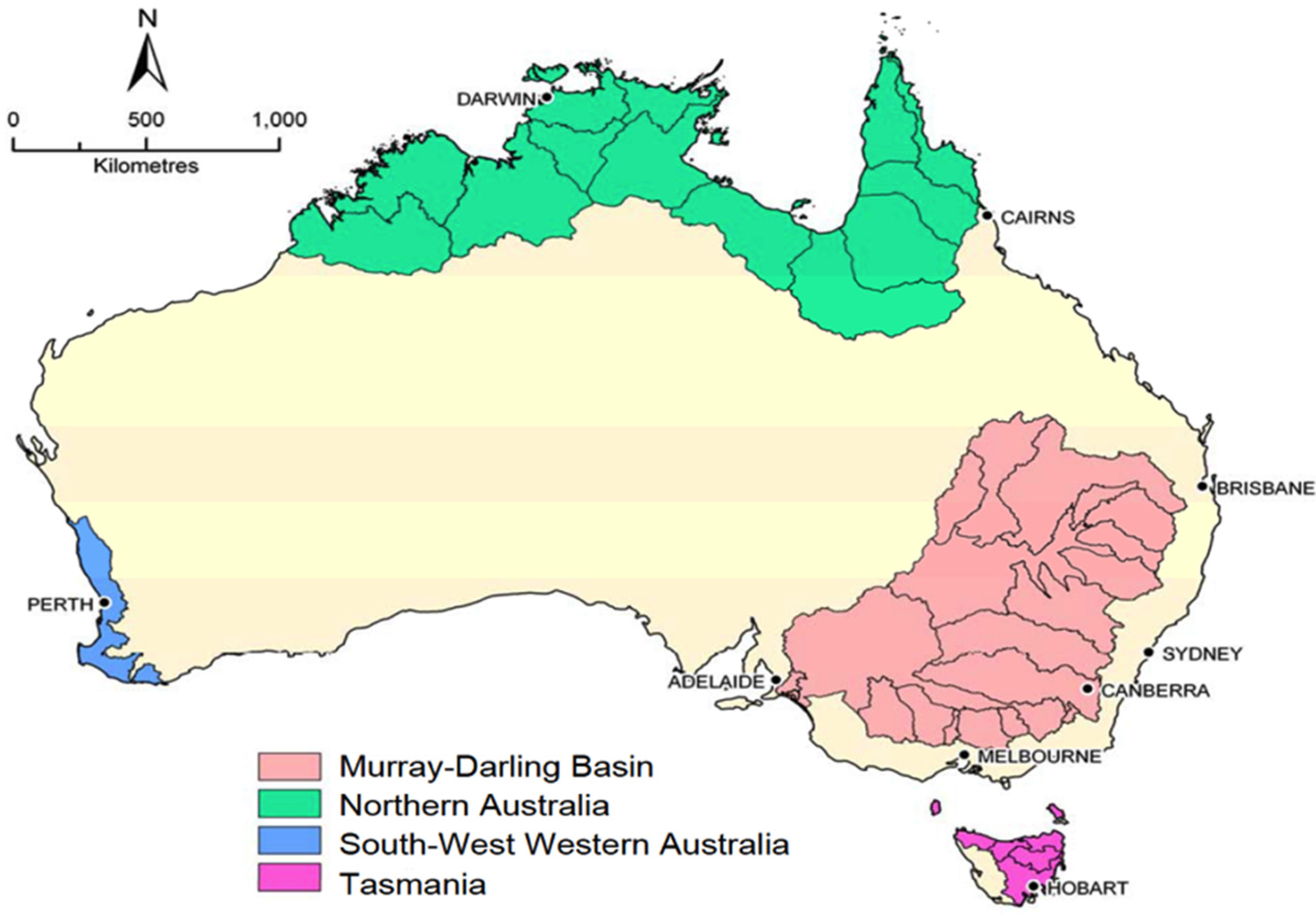
Later this work was extended, with the CSIRO undertaking water availability studies covering other major Australian water systems, to allow a consistent analytical framework for water policy decision-making [42,43]. These studies, undertaken between 2007 and 2012, covered both surface water and groundwater, and included modeling of the effects of climate change on water availability to 2030. The areas covered (shown in Figure 2) focused on “at risk” water basins, and areas where further expansion of activities involving water use was being proposed.
Figure 2.
CSIRO “Sustainable Yield” Studies. Source: [44].
Figure 2.
CSIRO “Sustainable Yield” Studies. Source: [44].

The studies were detailed desktop scientific analyses, involving cutting-edge modeling technology, and provided water information users with a much clearer understanding of water availability in key areas, and likely impacts of climate change in the medium term [38]. This was the first time such an analysis had been undertaken on a basin-wide basis. The MDB study was developed further as the MDB Plan was drafted, as issues such as appropriate sustainable diversion limits were considered [45]. Each study used technical skills not present at the state level, and a consistent rigorous methodology to examine catchment development, groundwater extraction, and climate change [46]. This has led to some fundamental reassessing of forward-looking water management options and risks. For example, the Northern Australia study expressed caution over the viability of new dams in Northern Australia [47], while the Tasmanian study provided detailed insights into the impacts of the expected drier climate on proposed irrigation scheme developments [48]. Two projects involved cross border investigations that had been hitherto unable to be undertaken. It was done by the respected independent national science “brand” and the methodology was repeatable across the country.
2.3.2. Broken Hill Managed Aquifer Recharge
Again, in an effort to provide improved basin-wide solutions to water problems, the national government commissioned Geoscience Australia, a respected national leader in groundwater modeling, to undertake research on groundwater resources in the Menindee Lakes area. The study has not only transformed understanding of groundwater around the Menindee Lakes, but has proven technology that will assist in transforming assessment of groundwater resources around the world [49,50]. While previous work had been undertaken at the state level, this study provided the basis for fundamental reappraisal of surface and groundwater management options in the study area itself, with basin-wide implications.
2.3.3. Bioregional Assessments
A third project (currently in progress) involves the national government undertaking detailed basin-wide, cross-border “bioregional assessments” in relation to water resources that may be affected by large-scale coal and unconventional gas mining activities. The regions covered by these assessments are set out in Figure 3.
Figure 3.
Bioregional Assessment Regions. Source: [51].
Figure 3.
Bioregional Assessment Regions. Source: [51].
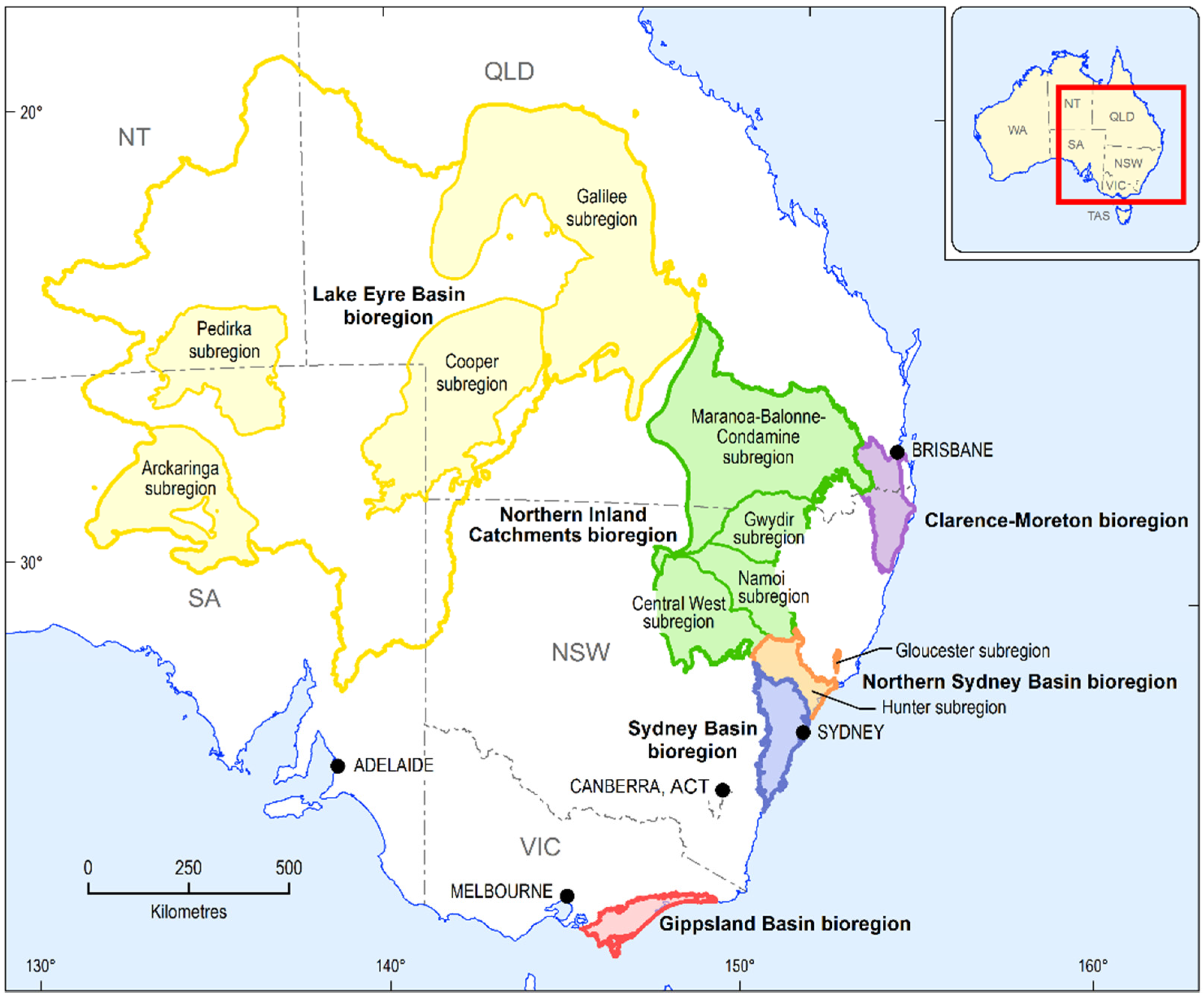
According to the Australian government, “bioregional assessments are world-first science-based studies that will develop detailed, multi-layered records of the environment and provide all interested stakeholders with a comprehensive, customized suite of baseline information and analysis about water resources in their local area. The assessments will examine the possible impacts of coal seam gas and large coal mining developments on water-related resources” ([52], p. 1).
The bioregional studies are supported by communities that want an assessment independent of the state governments that have backed large-scale resource projects. The studies should provide a sound basis on which to examine the cumulative impact of individual large-scale mining and agricultural development projects. Some of these studies are being undertaken “after the fact”; even then they will be useful to suggest whether given consents need to be altered in light of the future deterioration of a water resource. Ideally, these studies should have been undertaken before decisions on individual projects were made. For the other bioregional assessment regions, where the studies are preceding decisions on development (either water resources or other natural resources including unconventional gas and coal mining), the studies should provide sound baseline information as inputs to further decision-making.
Taken together, these three groups of studies form an important part of Australia’s water information system. The studies illustrate the importance of science and the importance of institution selection. They have all produced or are producing information of quite profound scientific and economic significance that will assist in making well-based public policy decisions and private investment decisions. These are all detailed studies with potentially profound long-term resource management implications (for an interesting article on this subject see Hirsch et al. [53]). How they are used in the public policy arena will depend very much on the regional, state, and national politics at the time, but at the very least decisions can be based on a materially improved baseline understanding of existing water resources.
3. Progress in Strengthening the Australian Water Information System
3.1. Qualitative Assessment of Improvements in Water Information
This author’s qualitative assessment of improvements in the availability of useful water information for rural and regional Australia since 2007 is set out in Table 1. These comments are grounded in published information series referenced in this article. Readers are encouraged to view this source material. Table 1 supports the proposition that national water information is playing an important role driving water reform and assisting sustainable water management and decision-making. It is now hard to imagine a world without useful data sets in most of the areas set out in this table. Yet a decade ago, many rows in Table 1 were close to being empty sets or, at least, data availability was at best piecemeal, not transparently available, and built on standards that often differed between states or individual water service providers.
However, information availability does not always settle questions. For example, the Australian political debate is still replete with untested assertions on the opportunities to develop new frontiers utilizing extant water resources, with limited consideration of sustainability [54].
Another case where enhanced science-based water information has been critical is in the MDB. The debate over the sustainable diversion limits in the MDB Basin Plan was underpinned by solid science, with the limits themselves being appropriately societal decisions [55]. Even now it is clear that farming bodies do not agree with the outcome [56]. In addition, mining companies still argue that any broad rules on water management should be altered to meet their needs [57]. These arguments will continue, but at least society can take basic decisions with a better understanding of some of the ramifications of that decision.

Table 1.
Water Information for Sustainable Water Management—Progress in Rural and Regional Australia since 2007.
| Type | Administering Agency | Authority | Comment | Beneficiary | Benefit |
|---|---|---|---|---|---|
| Water availability, supply and use | BOM; MDBA; ABS State water managers (e.g., New South Wales Office of Water) | Commonwealth Water Act; Water regulations; Basin plan ABS Act; State water legislation | Seasonal forecasting now routinely available. Short-term forecasting being trialed. Significantly improved timeliness streamflow data, volumes in storages, trade data. Overarching national water account in place but not well accepted. New technology (Geofabric, data cube, AWRIS) | Irrigators; environmental water managers; river operators; regional water providers; policy makers | Improved flood control and flood risk assessment; improved irrigator water ordering; improved river operations; improved demand management; improved environmental water use; better policy responses |
| Basic groundwater information | BOM State water managers | Commonwealth Water Act State water legislation | Groundwater levels and aquifer characteristics available online, along with national atlas of groundwater dependent ecosystems. New technology and investments in upgraded collection system (e.g., automated bore technology) providing significant improvement in basic data. | Small urban populations; irrigators; mining interests; NRM bodies | Better management of risk; draws attention to sustainability issues |
| Market regulation (MDB focus) | ACCC; BOM; MDBA State water managers State water regulators | Water charge and market rules; Water regulations; State-based regulations | Significant improvement in transparency; rules combined with publication of annual data on monitoring has led to improved market behavior. | Water entitlement holders; water users | More effective water portfolio/input management; increased market pressure on IIOs to perform |
| Market data—MDB focus (price and quantity) | Dept. of Environment State water registries BOM Private brokers | Water regulations State Water legislation | Entitlement and trade volumes reported but key benefit not yet realized as price data still poor. National water market system project abandoned, reflecting state intransigence and poor Commonwealth management. | Irrigators; environmental water managers; river operators; regional water providers; policy makers | More timely, cost-effective irrigator interventions; transparency; efficiency of water market |
| Basic water information (water access and irrigation rights, trades, allocation announcements) | BOM (until recently NWC and NWMS) State water managers | Water Act 2007; Water regulations; State Water legislation | Significantly improved basic data, but overall usefulness limited by inadequate price data and working common registry interface. | Irrigators; environmental water managers; river operators; regional water providers; policy makers | Strengthens market fairness |
| Environmental Watering | BOM, National and state environmental water managers | Various | Improved data on planned actions and ongoing activity. | Ecosystem | Optimizing ecosystem benefit from water flows; assuring other users of benefit from actions |
| Meteorological data affecting water resource availability | BOM | Water Act 2007, BOM Act, Water Regulations 2008 | Issue of further refining outputs to meet user needs. | Irrigators and farmers; water managers; river operators; environmental water managers; businesses | More effective irrigator use of water resources; Improved irrigator planning, more effective environmental water use |
| Water Quality | BOM State water managers | Water Regulations 2008 State Water legislation | Little progress outside of data collection on salinity. Little data collected on environmental water quality. | Irrigators and farmers; environmental water managers | Clear understanding of “fit for purpose” implications |
To buttress this ongoing debate, Australia now has rapidly developing information systems and databases that allow many more statements and propositions to be tested than was the case a decade ago. There is now a much better appreciation of the extent and characteristics of surface water assets, the rights governing their use, and the likely risks that might arise over time, and this helps to underpin and enhance water resource planning and management. There are still important shortcomings in some data sets, and important shortcomings in how users can access data that is already collected. Further progress is required, with specific attention to user requirements and whether all information being collected is required. However, many assertions that there is widespread duplication between information collections do not ring true; rather, they suggest that particular interests do not welcome being put under the microscope.
Understanding of ground water assets remains much more limited, and management of the resources is much less transparent and less uniform. The BOM’s online efforts here are encouraging [60].
3.2. Water “Abstractions” and “Use” in the MDB
In any upgrading process, care is clearly needed to avoid overlapping data series and effort and definitional differences collected by different agencies. As needs change, a difficult task is to ensure that data collections remain relevant and vital, to minimize regulatory and transaction costs, and maximize benefit to users. In the case of Australian water information, few national data series existed a decade ago that exist today. However, one important area that remains puzzling is data published on water use in the MDB, for which there are currently three published data series.
Currently the MDBA, BOM, and ABS publish data series on annual water use/water abstracted/water diverted in the MDB. The MDBA data initially came from state obligations to monitor and report water use in the MDB after the cap on extractions was introduced in 1996. The BOM publishes a series in its Water Account largely based on MDBA data, but this currently contains some definitional differences with the MDBA data, resulting in material differences in aggregate numbers. Finally, the ABS publishes survey/census data reflecting self-reported water used on farms that is quite different from the above series [15,29,61].
Two points can be made about these three data series. First, differences in total annual volumes are significant. For example, the BOM calculates water abstracted from water resources in the MDB in 2012–2013 at 11,896 GL. The ABS calculates water used in the MDB in 2012–2013 to be 8574 GL. The MDBA 2012–2013 data is not yet available, some 18 months after the completion of the reporting period. Definitional differences are confusing to both casual and serious users. The ABS farm “use” figures are some 27% less than BOM abstraction numbers. Definitional differences appear to explain much of the difference but there is no concordance available between the series to test their respective veracity. Published data does not allow this to be carried out. This is necessary from a public policy perspective to test what each series contributes to understanding.
Second, it is not that there has not been discussion over resolving differences, as there has, but that it takes considerable time to overcome administrative inertia when introducing change, particularly when new institutions are asked to play a key ongoing role. These data series illustrate how, when change occurs, considerable effort is required to reexamine the role played by the original information collections. As the quality bar is lifted, what previously was “useful” may need to be carefully reexamined.
4. Challenges and Lessons
This article has sought to describe and assess the impact of an increased national effort on water information and data collections, with a focus on rural and regional Australia (and particularly the MDB) over the decade to 2014.
The article shows that the recent decade of considerable resource investment in water information has produced real results and a much better understanding of rural and regional water resources, and resulted in an enhanced ability to manage them in a sustainable way. Increased resourcing and a political commitment to serious water reform have been important elements in progress. Three ongoing challenges are noteworthy. First, data collection needs to closely reflect the current and prospective needs of water information users. Effective communication with those stakeholders is critical. New information technology and scientific understanding allow new information products to be developed for users—cost and use are two key considerations for ongoing assessment of the content of Australia’s water information needs. Water information products and services need to focus strongly on user needs and delivering value to all data users, but have one eye to the future and cost versus benefits for data collection that may not appear to have a clear use today.
Second, there are interest groups that would prefer data to be collected at a state level, thus reducing standardization and comparability. Governments should strongly endorse standardization and transparency, rather than use “regulatory cost burdens” as reasons not to collect and disseminate necessary data. The BOM has stature as an independent non-evaluative source of data, unaffected by political interference, which has been present at the state level. It has put much effort into encouraging standardization of data, much like the ABS in the area of economic and social data (and, incidentally, is in the vanguard of developing standards for international use).
Third, some key data series, such as price and quantity of transactions in the water market in the MDB, could be improved dramatically and quickly if governments agreed there was value, with virtually no additional regulatory cost. This should be a priority for the MDBA, the BOM, and their information partners. The MDBA will need to ensure that states meet their commitments under the Basin Plan in this regard.
The applicability of the Australian approach of increasing the resourcing of national water information to other countries that perceive a need to upgrade their water information systems will depend in large part on where they are starting from, the legal framework in which water information is collected, the level of resourcing, the institutional and governance frameworks that are in place, the professional skill base, and the political and cultural forces that are either promoting or stifling reform.
The Australian experience suggests nine lessons for other countries:
- Upgrading a nation’s water information systems is a long-term task, but an important one in a world of climate change and increased climate variability. Substantial progress is likely to take five to 10 years to materialize. In the current political landscape anywhere in the world, this is a long time, so attention needs to be given continuously to the purpose of the exercise, and the benefits from it. As there is a tendency to forget the original baseline (particularly as crises dissipate), attention needs to be given to reiterating the value proposition, and ensuring that data collected covers issues relevant to users and in a form that is readily accessible to them.
- The process of upgrading is likely to require substantial new resources. This underscores the need to examine the case to continue existing data series as well as introduce new ones, and to take opportunities to lower collection and regulatory costs.
- Effective data series tend to be long ones, so each series should reflect a careful initial consultation and development process. From the outset, upgrading information systems needs to be focused on data series that will facilitate answering key policy questions, assist water users in making significant decisions more effectively, or equip businesses and government to better address risks from water-related events.
- As always, political support matters. Politicians generally have little sustained interest in these issues, so drawing out the key “good news” stories, and the benefits to users and the economy and environment will be vital to sustain the reform process.
- Developing large new information systems involving large IT systems is fraught with high project risk, which will require careful project management. The IT skill base and the skill base of the water professionals managing and delivering the new water information system will be critical in transforming it. Developing new tools often goes hand in hand with data collection and data dissemination to users. Understanding the user group and its needs, and the optimal way to make the data base easily accessible to that group, will play a critical factor in delivering the project.
- New information may radically alter the way both groundwater and surface water resources are viewed. New technology is resulting in radically new approaches becoming cost effective. Flexibility and, on occasion, risk taking will be required to ensure that new approaches can be introduced into information collections. New approaches require good governance arrangements, particularly if several levels of government are involved.
- Any new national data collection and dissemination exercise will require new approaches and relationships between water information managers and users.
- Information collection and dissemination should be put in the hands of bodies that can best produce the required products. Entrenched interests are very likely to argue why a new approach should not be followed, as new information may be detrimental to their interests. Their case should be given no more or less weight; each new series needs to be fully justified on its own merits.
- The success or failure of a new information system will in part be determined by how it is used. For many users, their acceptance will be based around such factors as the ability of the system to enhance analysis and understand risk, reduce transaction costs, and boost business viability. At a policy level, for governments, the yardstick for acceptance is somewhat different: it is more that governments and public sector managers can develop policy based on a good understanding of the country or region’s water resources. How it is used depends on the judgments and decisions of the decision-making body.
Upgrading Australian water information began in the middle of a crisis, and long after it was well known that existing water information was inadequate to make the decisions required. Seven years later, with the crisis having receded, governments appear to be giving the importance of information less weight. To sustain investments in information, its coverage must facilitate illuminating key questions and issues. Custodians of information systems must ensure that the value proposition is clear to all. Selling the case is critical. Communicating effectively with stakeholders is a key part of implementing and sustaining any successful upgrading program.
Acknowledgments
The author would like to thank colleagues and a referee for many useful comments on an earlier draft of this paper.
Conflicts of Interest
The author declares no conflict of interest.
References
- Maestu, J. Water Trading and Global Water Scarcity; RFF Press: Milton Park, Abingdon, UK, 2013. [Google Scholar]
- Grafton, R.Q.; Hussey, K. Water Resource Planning and Management; Cambridge University Press: Cambridge, UK, 2011. [Google Scholar]
- Horne, J. Economic approaches to water management in Australia. Int. J. Water Resour. Dev. 2013, 29, 526–543. [Google Scholar] [CrossRef]
- Maestu, J.; Gomez, C. Drivers of Economic Information in River Basin Planning. Int. J. Water Resour. Dev. 2011, 27, 665–676. [Google Scholar]
- OECD. Proceedings of the OECD Workshop on Improving the information base to better guide water resource management decision making, Zaragoza, Spain, 4–7 May 2010; Available online: http://www.oecd.org/greengrowth/oecdworkshoponimprovingtheinformationbasetobetterguidewaterresourcemanagementdecisionmakingzaragozaspain4-7may2010.htm (accessed on 25 January 2015).
- Parris, K. Improving the Information Base to Better Guide Water Resource Management Decision Making. Int. J. Water Resour. Dev. 2011, 27, 625–632. [Google Scholar] [CrossRef]
- Vertessy, R.A. Water information services for Australians. Aust. J. Water Resour. 2013, 16, 91–106. [Google Scholar] [CrossRef]
- Crase, L. Water Policy in Australia: The Impact of Change and Uncertainty; RFF Press: London, UK, 2008. [Google Scholar]
- Australian Governmen. Intergovernmental Agreement on a National Water Initiative; Australian Government: Canberra, Australian, 2004. Available online: http://www.nwc.gov.au/nwi (accessed on 25 January 2015).
- Raising National Water Standards Program—Evaluation Overview. Available online: http://www.nwc.gov.au/__data/assets/word_doc/0005/25349/RNWS-evaluation-overview.doc (accessed on 25 January 2015).
- Raising National Water Standards Program. Available online: http://archive.nwc.gov.au/rnws (accessed on 25 January 2015).
- Sinclair Knight Merz. The Need for Improved Water Data and Water Sharing. In Waterlines Occasional Paper No. 4; National Water Commission: Canberra, Australian, January 2008. Available online: http://archive.nwc.gov.au/__data/assets/pdf_file/0004/11020/improved-water-data-body-waterlines-0108.pdf (accessed on 25 January 2015). [Google Scholar]
- Cordery, I.; Weeks, B.; Loy, A.; Daniell, T.; Knee, R.; Minchin, S.; Wilson, D. Water Resources Data Collection and Water Accounting. Aust. J. Water Resour. 2007, 11, 257–266. [Google Scholar]
- Howard, J. A National Plan for Water Security; Australian Government: Canberra, Australian; pp. 1, 15.
- Australian Bureau of Statistics. 4618.0—Water Use on Australian Farms, 2012–2013. Available online: http://www.abs.gov.au/ausstats/[email protected]/Latestproducts/4618.0Main%20Features72012-13?opendocument&tabname=Summary&prodno=4618.0&issue=2012-13&num=&view (accessed on 25 January 2015).
- Australian Bureau of Statistics. 4655.0—Australian Environmental-Economic Accounts, 2014. Available online: http://www.abs.gov.au/AUSSTATS/[email protected]/Lookup/4655.0Explanatory%20Notes12014?OpenDocument# (accessed on 25 January 2015).
- Australian Bureau of Statistics. 4610.0—Water Account, Australia, 2012–2013. Available online: http://www.abs.gov.au/AUSSTATS/[email protected]/second+level+view?ReadForm&prodno=4610.0&viewtitle=Water%20Account,%20Australia~2012-13~Latest~27/11/2014&&tabname=Past%20Future%20Issues&prodno=4610.0&issue=2012-13&num=&view=& (accessed on 25 January 2015).
- Australian National Audit Office. Audit Report No.18 2013-14—Administration of the Improving Water Information Program. Available online: http://anao.gov.au/~/media/Files/Audit%20Reports/2013%202014/Audit%20Report%2018/AuditReport_2013-2014_18.pdf (accessed on 25 January 2015).
- Bureau of Meteorology. Publications—Improving Water Information Programme Progress Report 2013. Available online: http://www.bom.gov.au/water/about/publications/ (accessed on 25 January 2015).
- Bureau of Meteorology. Categories of Water Information. Available online: http://www.bom.gov.au/water/regulations/categoriesWaterAuxNav.shtml (accessed on 25 January 2015).
- Bureau of Meteorology. Publications–Information Sheets–3 Australian Water Resources Information System (AWRIS). Available online: http://www.bom.gov.au/water/about/publications/ (accessed on 25 January 2015).
- Bureau of Meteorology. Water Data Online. Available online: http://www.bom.gov.au/waterdata/ (accessed on 25 January 2015).
- Bureau of Meteorology. Design Rainfalls. Available online: http://www.bom.gov.au/water/designRainfalls/index.shtml (accessed on 25 January 2015).
- Engineers Australia. Australian Rainfall and Runoff Discussion Paper: An Interim Guideline for Considering Climate Change in Rainfall and Runoff Draft, November 2014. Available online: http://www.arr.org.au/wp-content/uploads/2013/Projects/Draft_ARR_interim_guidance_Format.pdf (accessed on 25 January 2015).
- Bureau of Meteorology. Australian Hydrological Geospatial Fabric (Geofabric). Available online: http://www.bom.gov.au/water/geofabric/index.shtml (accessed on 25 January 2015).
- Bureau of Meteorology. Modernisation and Extension of Hydrologic Monitoring Systems Program. Available online: http://www.bom.gov.au/water/regulations/fundingProgram/index.shtml (accessed on 25 January 2015).
- Bureau of Meteorology. Seasonal Streamflow Forecasts. Available online: http://www.bom.gov.au/water/ssf/ (accessed on 25 January 2015).
- Bureau of Meteorology. Assurance Engagements on General Purpose Water Accounting Reports. Available online: http://www.bom.gov.au/water/standards/wasb/gpwareports.shtml (accessed on 25 January 2015).
- Bureau of Meteorology. National Water Account. Available online: http://www.bom.gov.au/water/nwa/2013/ (accessed on 25 January 2015).
- CSIRO. WIRADA Annual Reports. WIRADA Annual Report 2013–2014. Available online: http://www.csiro.au/Organisation-Structure/Flagships/Water-for-a-Healthy-Country-Flagship/WIRADA-annual-reports.aspx (accessed on 25 January 2015).
- Geoscience Australia. Data Cube—The Future of Earth Observation Data Management and Analysis (narrated by Dr Adam Lewis). Available online: https://www.youtube.com/watch?v=AYB5Sw80Vfs&index=25&list=UUgglOEaXbvCJCrIj6R2EIBw (accessed on 25 January 2015).
- McCormick, B. Water: Budget Review 2014–2015 Index. Parliament of Australia. Available online: http://www.aph.gov.au/About_Parliament/Parliamentary_Departments/Parliamentary_Library/pubs/rp/BudgetReview201415/Water (accessed on 25 March 2015).
- Report of the Independent Review of the Water Act 2007. Available online: https://www.environment.gov.au/water/publications/report-of-the-independent-review-water-act-2007 (accessed on 25 January 2015).
- Speers, R.A. Report on upcoming experimental estimates of water resource stocks for Australia. In Proceedings of the 20th Meeting of the London Group on Environmental Accounting, New Delhi, India, 15–17 October 2014.
- Australian Competition and Consumer Commission. ACCC Role in Water. Available online: https://www.accc.gov.au/regulated-infrastructure/water/accc-role-in-water#monitoring-and-reporting (accessed on 25 January 2015).
- Grafton, R.Q.; Horne, J. Water Markets in the Murray-Darling Basin. J. Agric. Water Manag. 2014, 145, 61–71. [Google Scholar] [CrossRef]
- Australian Competition and Consumer Commission. ACCC Water Monitoring Report 2012–2013, April 2014. Available online: https://www.accc.gov.au/publications/accc-water-monitoring-report/accc-water-monitoring-report-2012-13 (accessed on 25 January 2015).
- National Water Commission. Australian Water Markets: Trends and Drivers 2007–2008 to 2011–2012; Commonwealth of Australia: Canberra, Australia, 2013.
- Australian Government. The National Water Market. Archived page 28 February 2014. Available online: http://web.archive.org/web/20140228235833/http://www.nationalwatermarket.gov.au/site-information/index.html (accessed on 25 January 2015).
- Australian Government. The National Water Market. Available online: http://www.nationalwatermarket.gov.au (accessed on 10 February 2015).
- CSIRO. Community attitudes towards science and technology in Australia. Available online: https://publications.csiro.au/rpr/download?pid=csiro:EP145330&dsid=DS1 (accessed on 1 April 2015).
- CSIRO. The Sustainable Yields Projects. Available online: http://www.clw.csiro.au/publications/waterforahealthycountry/sustainable-yields.html (accessed on 25 January 2015).
- Horne, J. Australian water policy in a climate change context: Some reflections. Int. J. Water Resour. Dev. 2013, 29, 137–151. [Google Scholar] [CrossRef]
- South-West Western Australia Sustainable Yields Project. PowerPoint presentation. Available online: http://www.clw.csiro.au/publications/waterforahealthycountry/swsy/pdf/SWSY-stakeholder-presentation-Bunbury.pdf (accessed on 25 January 2015).
- Young, W.; Bond, N.; Brookes, J.; Gawne, B.; Jones, G. Science Review of the Estimation of an Environmentally Sustainable Level of Take for the Murray-Darling Basin; A Report to the Murray-Darling Basin Authority from the CSIRO Water for a Healthy Country Flagship; CSIRO: Canberra, Australian, 2011. [Google Scholar]
- Petheram, C.; Rustomii, P.; Vleeshouwer, J. Rainfall-Runoff Modelling Across Northern Australia; A report to the Australian Government from the CSIRO Northern Australia Sustainable Yields Project; Water for a Healthy Country Flagship: Canberra, Australia, 2009. [Google Scholar]
- CSIRO. Water in Northern Australia: Summary of Reports to the Australian Government from the CSIRO Northern Australia Sustainable Yields Project. Available online: http://www.csiro.au/Portals/Publications/Research--Reports/NASY-Summary-report.aspx (accessed on 25 January 2015).
- CSIRO. Water Availability for Tasmania: CSIRO Tasmania Sustainable Yields Project. Available online: http://www.clw.csiro.au/publications/waterforahealthycountry/tassy/ (accessed on 25 January 2015).
- Lawrie, K.C.; Brodie, R.S.; Tan, K.P.; Gibson, D.; Magee, J.; Clarke, J.D.A.; Halas, L.; Gow, L.; Somerville, P.; Apps, H.E.; et al. Broken Hill Managed Aquifer Recharge (BHMAR) Project: Securing Broken Hill's Water Supply: Assessment of Conjunctive Water Supply Options Involving Managed Aquifer Recharge and/or Groundwater Extraction at Menindee Lakes: Data acquisition, processing, analysis and interpretation method; Record 2012/011; Geoscience Australia: Canberra, Australia, 2012. Available online: http://www.ga.gov.au/metadata-gateway/metadata/record/gcat_73819 (accessed on 25 January 2015).
- Geoscience Australia. Broken Hill Managed Aquifer Recharge. Available online: http://www.ga.gov.au/about/what-we-do/projects/water/broken-hill-managed-aquifer-recharge (accessed on 25 January 2015).
- Australian Government. Bioregional Assessments. Available online: http://www.bioregionalassessments.gov.au (accessed on 25 January 2015).
- Australian Government. Factsheets—Bioregional Assessments. Available online: http://www.bioregionalassessments.gov.au/factsheets.shtml (accessed on 25 January 2015).
- Hirsch, R.M.; Miller, T.L.; Hamilton, P.A. Using Today’s Science to Plan for Tomorrow’s Water Policies. Environment 2001, 43, 8–17. [Google Scholar] [CrossRef]
- Campbell, A.; Turnour, J. We need a smarter debate on developing northern Australia. The Conversation. 13 August 2013. Available online: https://theconversation.com/we-need-a-smarter-debate-on-developing-northern-australia-16846 (accessed on 16 February 2015).
- Australian Government. Australian Government Response to the Senate Rural and Regional Affairs and Transport References Committee Report: Management of the Murray-Darling Basin System: Second Interim Report: The Basin Plan; Australian Government: Canberra, Australian, March 2013.
- National Farmers’ Federation. Review of Water Act 2007 Submission. Available online: http://www.environment.gov.au/minister/birmingham/2014/mr20141219.html (accessed on 25 January 2015).
- Minerals Council of Australia. Submission to the 2014 Review of the Water Act 2007. Available online: http://www.environment.gov.au/water/legislation/water-act-review (accessed on 25 January 2015).
- Extended Hydrologic Prediction Services for Improved Water Resources Management: An Australian Perspective. Global Water Forum. Available online: http://www.globalwaterforum.org/2015/03/02/extended-hydrologic-prediction-services-for-improved-water-resources-management-an-australian-perspective/ (accessed on 20 March 2015).
- Docker, B.; Robinson, I. Environmental water management in Australia: Experience from the Murray-Darling Basin. Int. J. Water Resour. Dev. 2014, 30, 164–177. [Google Scholar] [CrossRef]
- Bureau of Meteorology. Australian Groundwater Explorer. Available online: http://www.bom.gov.au/water/groundwater/explorer/map.shtml (accessed on 9 February 2015).
- Murray Darling Basin Authority. Water Audit Monitoring Reports. Available online: http://www.mdba.gov.au/what-we-do/managing-rivers/the-cap/wam (accessed on 25 January 2015).
© 2015 by the authors; licensee MDPI, Basel, Switzerland. This article is an open access article distributed under the terms and conditions of the Creative Commons Attribution license (http://creativecommons.org/licenses/by/4.0/).
Share and Cite
MDPI and ACS Style
Horne, J. Water Information as a Tool to Enhance Sustainable Water Management—The Australian Experience. Water 2015, 7, 2161-2183. https://doi.org/10.3390/w7052161
AMA Style
Horne J. Water Information as a Tool to Enhance Sustainable Water Management—The Australian Experience. Water. 2015; 7(5):2161-2183. https://doi.org/10.3390/w7052161
Chicago/Turabian StyleHorne, James. 2015. "Water Information as a Tool to Enhance Sustainable Water Management—The Australian Experience" Water 7, no. 5: 2161-2183. https://doi.org/10.3390/w7052161