Article

Application of Multivariable Statistical and Geo-Spatial Techniques for Evaluation of Water Quality of Rudrasagar Wetland, the Ramsar Site of India

1
Department of Geography and Disaster Management, Tripura University, Suryamaninagar 799022, India
2
Institute of Socio-Economic Geography and Spatial Management, University of Gdansk, 80-309 Gdańsk, Poland
3
Department of Statistics, Tripura University, Suryamaninagar 799022, India
4
Department of Chemical and Polymer Engineering, Tripura University, Suryamaninagar 799022, India
5
Gheorghe Balș’ Technical College, 107 Republicii Street, 625100 Adjud, Romania
*
Authors to whom correspondence should be addressed.
Water 2023, 15(23), 4109; https://doi.org/10.3390/w15234109
Submission received: 21 September 2023 / Revised: 17 November 2023 / Accepted: 21 November 2023 / Published: 27 November 2023
(This article belongs to the Special Issue The Impact of Climate Change and Land Use on Water Resources)

Abstract

:
The water quality of Rudrasagar Lake, the second-largest natural reservoir of Tripura is of great ecological and economic importance as it serves a diverse range of purposes, including fishing, irrigation, aquaculture, domestic use, and recreation activities. This study investigates the water quality of the study area, an esteemed Ramsar site in North Eastern India, using a combined application of multivariable statistical and geospatial techniques. In this study, 24 water samples were designed based on their use and collected along the periphery and the inner areas of the lake employing the Latin Square Matrix. This research also examines the spatial variations of water quality involving quartile-based water quality categorization of parameters, with Pearson’s Correlation analysis, Principal Component Analysis (PCA), and Hierarchy Cluster Analysis (HCA) applied for dimension reduction. The analysis involved quartile-based water quality categorization of parameters, with PCA and HCA applied for dimension reduction. Meanwhile, the Inverse distance weighted (IDW) approach was used to interpolate the spatial distribution of the quartile score using the ArcGIS platform. The Bureau of Indian Standards (BIS) was followed for water quality assessment. The results revealed significant spatial variation, providing valuable insights for future water management strategies. PCA indicates 57.26% of the variance in the dataset, whereas samples were classified into three subgroups and two groups in a dendrogram representing the result of the HCA. This study demonstrates the utility of PCA, HCA, and IDW interpolation in water quality assessment, highlighting the effect of human-induced activities in the lake’s vicinity.

1. Introduction

Wetlands are essential components of ecosystems, contributing an important role in maintaining biodiversity, providing unique ecosystem services, poverty alleviation, and supporting both terrestrial and aquatic life [1,2,3]. The growing global population has heightened the demand for water, further emphasizing the scarcity of safe water due to the degradation of aquatic resources over time. Moreover, surface water is frequently less preferable for human use due to its greater susceptibility to contamination and pollution. The quality of many surface and groundwater systems is rapidly declining due to the impact of several human activities, including encroachment, destruction of aquatic resources, siltation, mud trapping, agricultural discharge, and inadequate waste management [4,5,6,7,8]. Water quality is being evaluated to know/measure the hydro-geochemical nature, pollution level of water, aquatic ecosystem status, and impact of anthropogenic activities.
Rudrasagar, a precious wetland located in the Gomti River basin, was internationally recognized as being a Ramsar site in 2005. The study site is not only recognized for its ecological significance but also for its vital role in providing water for domestic use, irrigation, fishing, sinking zones for wastewater, and recreational activities. The water quality of the Rudrasagar wetland is of utmost importance due to its significant biodiversity and increasing anthropogenic activities in its vicinity. In light of the growing awareness of the important role of wetland water quality in protecting public well-being and aquatic ecosystems, there is an urgent need to assess and monitor surface water quality. Recognizing the need for a comprehensive assessment of water quality in the Rudrasagar wetland, this study used a combination of advanced statistical tools and geospatial techniques. Systematic monitoring and assessment of water quality is essential for the strategic management of water resources. The study of water quality has formed an important aspect of research worldwide. In the last few decades, studies on these aspects have been contributed by [2,3,9,10,11,12]
Research methods include collecting water samples following proper protocols from different locations within and around the lake. In recent years, statistical techniques have been widely applied to various environmental issues, including evaluating water quality, investigating spatio-temporal trends of heavy metal contamination, and identifying biological elements contaminating water [8,13,14,15,16]. Advanced statistical techniques have been widely adopted to assess the spatio-temporal variation of water quality [17,18,19,20]. These tools are effective and often used for analysis of the physical and chemical properties of water, making them suitable for measuring extensive environmental datasets [16,21,22,23,24]. HCA is a valuable tool for water quality analysis because it helps in recognizing patterns, homogeneity, clustering samples, and conducting comparative analyses, all of which contribute to a more comprehensive understanding of water quality. Various water quality parameters were chosen for analysis following previous research works by [2,11,19,24,25]. Advances in statistical tools, with Artificial Neural Networks (ANN), have opened a new dimension in different research domains that contribute to deeper insights into the identification of underlying issues in multi-decision-making processes [26]. In hydrology, machine learning algorithms can be applied in predicting pollutant levels, evaluating the influence of variables on water quality, and optimizing decision making for the implementation of management strategies [27,28,29,30].
Studies have investigated the impact of anthropogenic activities on the quality of lake water of the study area. It has been indicated that the lake water in this area is polluted remarkably. The lake status was determined using quartile-based categorization, Pearson’s Correlation, PCA, and HCA. The study followed the Bureau of Indian Standards (BIS) guidelines for comparing the conditions with the desired range of water to ensure the reliability and accuracy of water quality assessment. In addition to using statistical analysis, geospatial tools and techniques are used to interpolate the spatial distribution of water quality parameters. The IDW interpolation, which is unique in this particular study area, is employed using the ArcGIS platform, which enables mapping of spatial variations in water quality across sampling sites. This spatial analysis helps to formulate strategies for effective wetland management and conservation, helping to identify areas with distinct water quality characteristics.
In this study area, a very limited comprehensive study determines the dynamic and complex nature of surface water quality using the Inverse Distance Weighted (IDW) technique and application of geospatial techniques [31]. This study aims to investigate the water quality along with the reason behind the deterioration of the lake. The authors have also tried to assimilate the IDW technique and statistical approach in this research. The results of this study are expected to provide valuable insights into the dynamics of water quality within the Rudrasagar wetland. Combining the power of multivariate statistical and geospatial techniques, this research has provided excellent illustrations of water quality, highlighting the impact of local factors and anthropogenic activities on wetland health. Ultimately, research findings will help local authorities inform decision making and strategies for sustainable restoration and rejuvenation of the Rudrasagar wetland, ensuring its continued ecological health and the well-being of the communities that depend on it. Some examples of diverse approaches applied in the field of water quality assessment are discussed in the Contemporary research section.

1.1. Contemporary Research

Introduction to the scope of a comprehensive literature review on water quality analysis, covering various topics related to assessment and evaluation. Various studies conducted in different locations, starting with Pratapgarh District in Uttar Pradesh, have focused on assessing water suitability for drinking and domestic use, revealing excessive levels of various parameters [25]. A study on the water quality of Loktak Lake [32] highlighted that the overall water quality remained within desirable limits. A study in Vietnam [19] utilized integrated statistical approaches to assess spatial and temporal variations in surface water quality. Similarly, in the context of a European steppe lake [33], a combination of cluster and discriminant analysis techniques was applied to evaluate water quality. Surface water quality analysis [34] using multivariate statistical methods revealed elevated physical and microbial loads. There was the application of advanced statistical tools to determine pollution loads in the Yamuna River resulting from industrial projects [35]. Major pollution sources were identified in the three gorge areas of China, using FA, HCA, and non-parametric tests [36]. Other related works were conducted using PCA and HCA [37,38,39]. PCA and CA methods were applied to classify sampling sites and identify contamination sources in various studies [40]. An evaluation of variations was made in nutrients within a eutrophic reservoir, herbicide compositions, and spatial and temporal trends of heavy metal contamination using the PCA technique [33,41,42]. Furthermore, an analysis of the water quality of the Karoon River was conducted by [43]. These studies showed a transition to the use of different scientific methods, including the water quality index, pollution load index, and statistical techniques. A contemporary study, in Tripura, focused on covering various water bodies and using modern methods and advanced statistical tools [44,45,46,47]. In this study area, the authors applied different scientific methods: water quality index (WQI), and pollution load index (PLI), along with statistical analysis. Researchers often apply the water quality index but very rarely apply multivariable statistical techniques. IDW is one of the most effective geospatial tools, popularly used to interpolate and model the target parameters in the field of hydrology [48]. It was developed for mapping and modeling spatial distribution maps, such as water quality parameters [32,49]. In this study, the IDW interpolation approach was used to interpolate the spatial distribution of water quality scores for identifying the spatial variation of the Rudrasagar Lake. Additionally, two more statistical methods such as PCA and HCA were also used to study the water quality of Rudrasagar Lake. This research has provided excellent illustrations of the water quality of Rudrasagar Lake with the combined application of multivariable statistical approaches and IDW techniques.

1.2. Novelty of the Work

The novelty of the study comes under addressing current challenges and gaps in knowledge using innovative methods and technologies. By exploring previously studied aspects of water quality and their implications for human well-being and the environment. There are several research works conducted on this study area but there is a lack of comprehensive investigations incorporating multivariable statistics along with geospatial mapping. The study uses innovative methods and techniques, which can bring novel insights and approaches to the field. The selection of sampling sites using the Latin Square Matrix is also a unique method in this aspect. The overall significance of employing multivariable statistical approaches and IDW techniques in providing valuable insights into Rudrasagar Lake’s water quality. Utilizing quartile values for characterizing sample sites also contributes to the novelty of the research.

2. Materials and Methods

2.1. Description of the Study Area

The present study was carried out at Rudrasagar Lake, located in the western part of Tripura (Figure 1) at geo-coordinates 23°29′–23°31′ N latitudes and 90°18′–90°19′ E and covers a surface area of about 2.8 km2. The lake is a low-land sedimentation reservoir, receiving flow from three perennial tributaries: Noa cherra (15.7 km), Durlavnarayan cherra (3 km), and Kamtali cherra (4 km). The Rudrasagar catchment consists of two sub-catchments: Durlavnarayan-Kamtali cherra and Noa cherra. The Durlavnarayan-Kamtali cherra sub-catchment, drained by Durlavnarayan and Kamtali cherra, covering an area of 28.96 sq km, and Noa cherra sub-catchment, drained by Noa cherra, covers an area of 102 sq km. The eastern side of the lake features its deepest point, measuring 3.1 m in depth at coordinates 23°30′06″ N and 91°19′03″ E, whereas the western side (23°30′18.14″ N and 91°18′50.57″ E) is characterized by relatively shallower waters with a depth of 31 m. Over time, the average depth of the lake has been decreasing, attributed to anthropogenic activities such as agriculture in the catchment area, sewage deposition, high siltation, and accumulation of other debris from the surrounding hillocks of soft sediment formation. The lake takes on an amoeboid shape and links to the Gomti River near Battali Bazar (23°29′54″ N and 91°17′50″ E) on its western side through a narrow channel called Kachigang, measuring 22.49 m in width and extending over a length of 3.0 km.

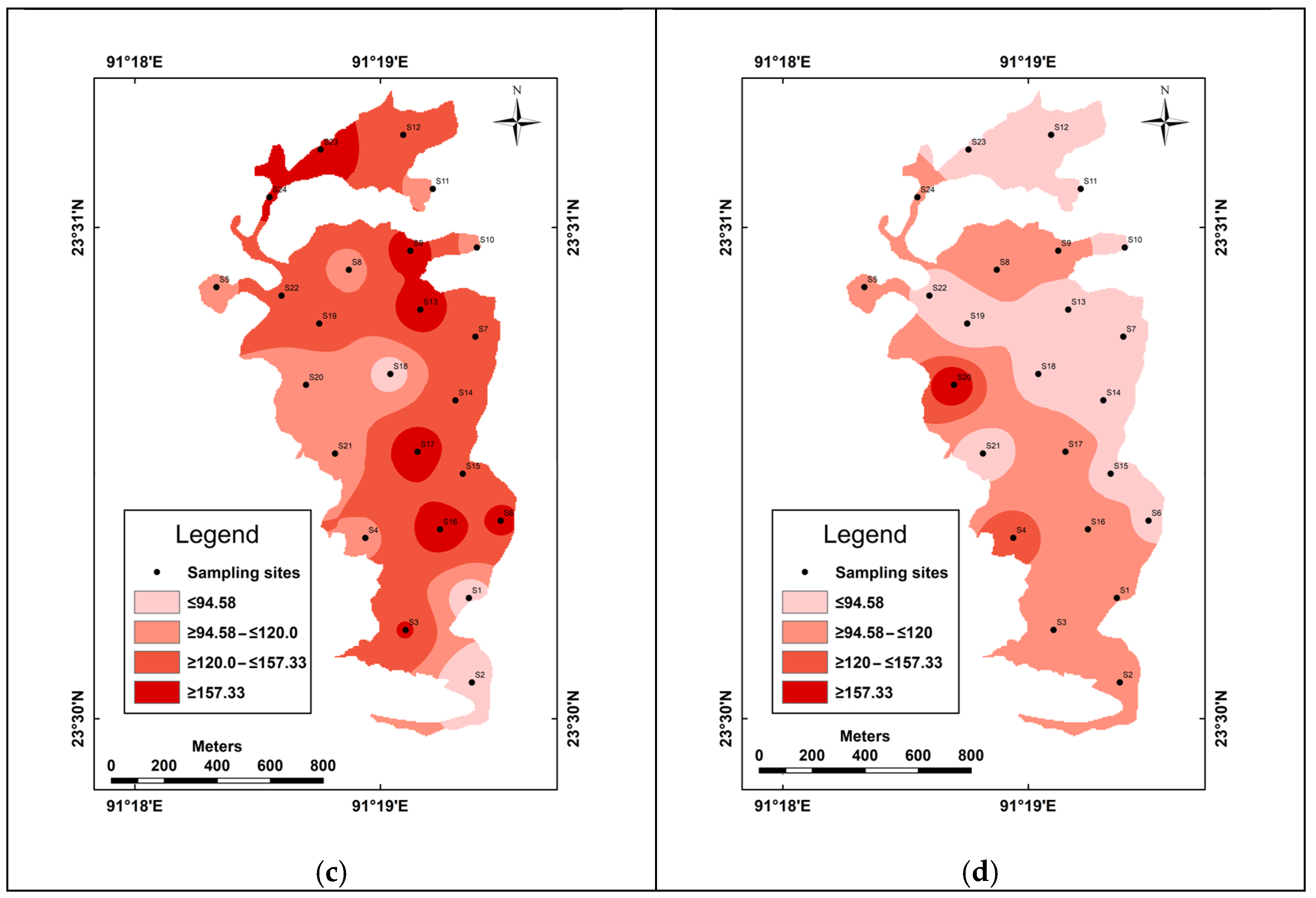
2.2. Description of the Sampling Sites

The materials and methods include a flowchart illustrating the procedural steps followed in the study (Figure 2). The field survey was carried out during the dry season from March to June 2022 to collect samples. Sample sites were selected using the Latin square matrix approach with dimensions of 500 m × 500 m, forming a square matrix with ‘n’ rows and columns to ensure each sample occurs in each grid. In this study, we required twenty-four (24) grids to cover the entire lake, with one sample collected from each grid to prevent repetition within the 0.25 sq km area. Considering environmental and socio-economic attributes, we designed twenty-four (24) sampling sites for monitoring the physical and chemical properties of Rudrasagar Lake water. Sampling sites were characterized by two groups: peripheral sampling and inner sampling.
Peripheral sampling sites include Rajghat (Ferryghat and idol immersion site), Devnagar (600 m behind the Melaghar Bus Stand), Ghrantali Madrasa (40 m from the non-functional brick field), Indiranagar (inactive brick field around 100 m), Battali (Battali market near 100 m), Kachhigang (mouth of discharging point), Dashamir Ghat (80 m from Chandnmura gram panchayat office), Chauhan Basati (near secondary school), Rajendranagar (back side of the primary school), Old Rangamura (near poultry farm), Letamura (600 m far from Kemtali bazar), Yubrajghat (idol immersion site). Sampling sites and their significance are represented in Table 1. Two monitoring sites, S8 (Neermahal back side) and S9 (Neermahal front side), are located around the Neermahal Palace, the famous tourist destination that is well connected with the highway network [50]. S10 is located at Katamura, which is characterized by a cemetery. Five samples were collected S13, S15, S16, S18, and S19 along the ferry route of the lake. All monitoring sites were situated at elevations of 10 to 30 m above sea level. The selected sample sites were demarcated by Garmin GPS receiver and illustrated in Figure 1d.

2.3. Sampling Procedure

The sampling procedure for water quality analysis involved selecting twenty-four strategic locations, the Rudrasagar Lake, covering both the periphery and inner areas. For this study, a total of 24 samples were collected. These locations were determined using a Latin square matrix, discussed earlier. At each of these sites, water samples were collected from a depth of approximately 0.5 m. All water samples were carefully collected and preserved in one-liter brown-colored amber bottles, which had been thoroughly cleaned by rinsing with hydrochloric acid (HCL), multiple rinses with normal water, overnight soaking in 10% nitric acid (HNO3), and a final rinse with distilled water (dH2O). The samples were then stored in insulated and ice-cooled containers during transportation to the laboratory for processing and further analysis. This meticulous sampling and preservation process ensured the integrity of the water samples and the accurate assessment of water quality parameters.

2.4. Selected Parameters

While numerous water quality parameters are available, we carefully chose 12 widely recognized variables (Figure 2) to assess the spatial variation of water quality in this study. For the sake of precision and due to data limitations, biological parameters are not included in this assessment. The key parameters selected for analysis, including temperature (temp.), electrical conductivity (EC), oxidation-reduction potential (ORP), the potential of hydrogen (pH) level, and dissolved oxygen (DO), were measured in situ by using Hanna Multiparameter (HI9829) and Winkler’s method, whereas biochemical oxygen demand (BOD), total dissolved solids (TDS), total suspended solids (TSS), total solids (TS), total hardness (TH), and total alkalinity (TA) were analyzed in the laboratory following the standard protocol of APHA (2012). TDS, TSS, and TS were measured following the Howard method. DO was determined by Winkler’s method while BOD used the same protocol after 72 h of incubation in the BOD incubator at 27 °C. The titrimetric method was used to determine the total alkalinity and hardness of water. Turbidity was measured by thermos scientific portable turbidity meter (ECTN100IR).

2.5. Statistical Analysis

In this study, we used IBM SPSS Statistics software v.27 for all statistical analyses of the dataset. The lake water quality dataset was subjected to multivariate statistical analysis, including PCA and HCA. In this study, it is applied to minimize dimensionality and determine spatial homogeneity for grouping sampling sites to assess a large dataset and interpret the variance by converting them into a smaller set of independent variables [36,37,38,39,51]. HCA was used to cluster sampling sites based on their variable characteristics, while PCA was used to reduce data complexity and create a more reliable set of uncorrelated variables providing a holistic perspective rather than isolated assessments of individual factors, while minimizing the loss of original information. This approach allows for more effective analysis and comprehensive interpretation, which helps identify patterns and trends in water quality across the study area. HCA is carried out following the means of Ward’s method, using Euclidean squared distance metrics as a measure of similarity.
PCA involves several steps, including covariance matrix computation and eigenvector decomposition, and it is simplified as X is the data matrix with n samples and p variables. Standardize the data by subtracting the mean and dividing by the standard deviation for each feature (Equation (1))
z = x u σ
where Z is the standardized data matrix, x denotes the original data matrix, u represents the mean vector of x, and σ defines the standard deviation vector of x. Further, calculate the covariance matrix (c) for the standardized data using the following formula (2).
c = 1 n z t z
where C stands for the covariance matrix, and find the eigenvalues (λ1, λ2,……, λp) and corresponding eigenvectors (v1, v2,……, vp) of the covariance matrix C. Selecting Principal Components choose the top k eigenvectors (principal components) based on the explained variance. These eigenvectors form the matrix (Vk).
Finally, project the standardized data z into the selected principal components using Equation (3).
y = z k
where y indicates the reduced-dimensional data matrix, and Vk denotes the matrix of the top k eigenvectors.

2.6. Quartile Deviation

For this study, we apply quartile deviation to understand the spread or variability of data within a dataset. It provides valuable information about the distribution of water quality parameters. It also helps in assessing how water quality parameters are distributed around the median or the central value. We have used quartile deviation because it provides insights into data dispersion, facilitates comparative analysis, is robust in the presence of extreme values, and aids in understanding data skewness. It is particularly valuable for assessing data variability and ensuring the reliability of water quality assessments. It can be mathematically defined as equal to half of the difference between the upper and lower quartiles. The quartile deviation provides a measure of the spread or dispersion of data between the 25th and 75th percentiles of the dataset, making it a robust measure of data variability. Q3 denotes the upper quartile and Q1 indicates the lower quartile. Mathematically, it can be expressed as:
Q d = Q 3 Q 1 2
where Q3 represents the third quartile (75th percentile) and Q1 represents the first quartile (25th percentile) of the dataset. In this study, the samples were classified into four categories: very low (≤Q1), low (>Q1 to ≤Q2), moderate (>Q2 to ≤Q3), and high (>Q3) concentration. The spatial variation of the samples was classified based on the quartile value of the samples.

2.7. IDW Interpolation

Analytical values of the variables were interpolated by inverse distance weighting (IDW) techniques in ArcGIS platform (v.10.3.1) for determining the spatial variation of water quality of the study area. IDW interpolation estimates unknown values by specifying search distance, closest points, power setting, and barriers. The calculation procedure of the IDW interpolation was performed through the following formula.
Z p = i = 1 n z i d i p i = 1 n 1 d i p
where the sigma notation simply means that you are adding whatever number of points will be interpolated. Here, we are simply summing the value of variables at each monitoring station for distance.

3. Results and Discussion

3.1. Temperature (°C)

Water temperature is a critical physical parameter that influences its suitability for human consumption. Temperature influences the rate of chemical and biological processes in water and regulates the maximum DO concentration within the water. It directly impacts the health and stability of aquatic ecosystems and affects the metabolic rates of aquatic organisms, including fish, bacteria, and phytoplankton, influencing their growth, reproduction, and overall well-being. Rapid temperature fluctuations or excessively high temperatures can indicate potential environmental stressors or pollution in the water. The maximum temperature is recorded in S17 (32.56 °C), whereas the minimum temperature is in S12 (28.02 °C). As the samples were collected during the summer season (April–May), water body temperatures ranged from 28.02 °C to 32.56 °C, with an average of 30.96 °C and a standard deviation of ±1.34 °C, indicating variability during the study period. About 21% of samples exceed 31.80 °C at S2, S3, S4, S6, and S17, while 25% sample fall below 30.10 °C at S7, S8, S11, S12, S14, and S15 (Figure 3a). This analysis provides strong support for the previous study conducted in Rudrasagar Lake by [52,53]. A comparable trend has been noted in other aquatic environments by [44,45,47]. Deeper layers of the study area tend to be cooler, while surface layers are influenced more by solar heating and may be warmer. According to local reports, this area has a high population density, leading to frequent activities like bathing, washing, and other anthropogenic actions by the local residents. It is possible that surface waters become contaminated during the transportation of household waste.

3.2. pH

pH serves as a fundamental and critical physical indicator of water quality, reflecting the hydrogen concentration in the water. Natural water typically exhibits a slightly basic pH due to the presence of carbonates and bicarbonates. The pH levels in water vary throughout the day, increasing during daylight hours as a result of photosynthetic processes and declining at night due to respiratory activities. The recommended pH threshold for drinking water is 6.5 [54]. The pH in Rudrasagar Lake ranges from 6.34 to 7.90, with a mean value of 6.90 ± 0.43. Among the 24 samples collected, the lowest pH was observed at S19 with a value of 6.34, and 4% of the samples had the lowest pH in the study area. Most of the samples fall within the permissible pH range as per BIS (6.5–8.5), with approximately 75% of the samples in this category. About 71% of the samples across 17 sampling sites fall within moderate pH levels according to the quartile deviation method including S9 (6.53), S5 (6.54), S17 (6.59), S23 (6.60), S16 (6.61), S3 (6.63), S4 (6.65), S7 (6.66), S6 (6.66), S12 (6.71), S20 (6.76), S14 (6.76), S13 (6.77), S15 (6.77), S24 (6.92), S18 (6.92), and S1 (6.94). While approximately 25% of the sample stations exhibit maximum pH levels, notable examples include S22 (7.05), S8 (7.74), S11 (7.75), and S21 (7.90). However, the analysis indicates that some water samples fall below the desirable limits (6.5–8.5), with only one sample station (S19) falling below the standard threshold of 6.5 (Figure 3b). The pH level of water can vary due to various natural and human-induced factors. Human activities, including pollution from industrial discharges, agricultural runoff, and the use of certain chemicals, can significantly impact water pH. It is possible that discharged water from residential and Melaghar Municipality areas may have contributed to the observed pH levels in Rudrasagar Lake. Understanding these factors is essential for assessing water quality and its suitability for various purposes, from sustaining aquatic life to serving as a source of drinking water. The pH values in the lake show minimal variation and are consistently slightly acidic (6.2–6.8) across 62.5% of the samples.

3.3. Oxidation-Reduction Potential (mV)

A high oxidation-reduction potential (ORP) value indicates abundant oxygen in the water, enhancing the efficiency of bacteria in decomposing organic matter and contaminants. Lake water’s ORP ranged from 90.40 to 136.73 mV, with an average of 116.58 ± 13.91 mV. The highest ORP was recorded at site S17 (136.73 mV), while the lowest was at sampling station S2 (90.40 mV). Approximately 29% of monitoring stations had low ORP, and 25% had very low ORP levels. This suggests a prevalence of low ORP values during the study, indicating potential chemical reactions. Moderate ORP levels were observed at stations S24 (128.70), S13 (135.13), S19 (120.10), S9 (131.97), S16 (134.33), and S1 (94.03), with more than 38% of the samples exceeding 120 mV (Figure 3c). The primary anthropogenic contributors to ORP variation are the discharge of wastewater and residential effluents into the study area. These discharges often contain organic compounds and pollutants, leading to increased microbial activity and potential oxidation-reduction reactions, thus affecting ORP. Agricultural runoff, with its load of fertilizers and pesticides, can influence substantially. Urbanization and land-use changes can result in altered water flow patterns, affecting oxygen levels and ORP. Furthermore, human intervention around the lake such as construction, and changes in land cover can influence the sedimentation and erosion processes, potentially releasing substances that alter ORP. Anthropogenic factors play a significant role in ORP variations, making it crucial to monitor and manage these influences to maintain healthy aquatic ecosystems and water quality.

3.4. EC (μS/cm)

Electrical conductivity (EC) serves as an indicator of the physical pollutant load within water. Higher EC values are indicative of poorer water quality, with the established standard limit for EC in drinking water set at 300 μS/cm. Our analysis has classified the EC values into four distinct categories: low EC (<100), moderate EC (100–200), good EC (>200), and very good EC. During the study period, the EC levels at the sampling sites exhibited a range from 51 to 350 μS/cm, with an average value of 132.85 ± 64.37 μS/cm. Notably, all the EC values were found to be well within the threshold value for drinking and domestic use recommended by BIS, which is <300 μS/cm. Specifically, sites S19 (51.67), S13 (69.33), S11 (75.00), S21 (77.00), S14 (86.67), and S23 (87.33) displayed very low conductivity. Furthermore, 85% of the samples registered EC values below 177 μS/cm during the study period, accounting for a quarter of all monitoring sites. Five water sample stations, S1 (127), S3 (127), S2 (134.33), S24 (155.00), and S5 (157), were categorized as having moderate EC, making up 21% of the total sample sites. In contrast, six water sample stations demonstrated good electrical conductivity, representing 25% of all samples. These noteworthy stations are S8 (157.66), S17 (166), S16 (177), S9 (182.7), S4 (252.3), and S20 (350.7). Lastly, sample sites S15 (97), S7 (97.67), S12 (99.7), S18 (106.3), S10 (116), S22 (118), and S6 (120) exhibited low conductivity, constituting around 30% of the total monitoring sites. The analysis reveals that the water sample stations’ EC values consistently meet the standard criteria for healthy water quality, as depicted in (Figure 3d). Anthropogenic causes for variations in water electric conductivity (EC) include industrial pollution, agricultural runoff, urbanization, and the discharge of municipal wastewater. These human activities introduce contaminants and dissolved solids, affecting the EC and water quality in natural water bodies.

3.5. Total Alkalinity (mg/L)

Water alkalinity reflects its ability to neutralize acids, indicating its capacity to absorb H+ ions without significant pH changes. The primary contributors to natural water alkalinity are hydroxide, carbonate, and bicarbonate ions. While alkalinity is generally non-harmful to life, the BIS set a domestic use standard of 200 mg/L in 2012. During the study, collected water samples exhibited alkalinity values ranging from 70.00 to 190.00 mg/L, falling within the standard range of 151 ± 31.27 mg/L. Notably, sample station S24 recorded the highest alkalinity at 190 mg/L, while S20 had the lowest at 70 mg/L. The alkalinity values varied across stations. However, specific water sample stations, including S18 (120), S19 (120), S23 (120), S2 (126), S3 (126), S1 (127), S12 (128), S16 (128), and S4 (140) from Rudrasagar Lake, consistently maintained alkalinity levels within the standard range (Figure 4a). Anthropogenic causes for changes in water alkalinity result from human activities, including agricultural practices, industrial discharges, and municipal wastewater release, which introduce alkaline substances into water bodies. These activities can impact aquatic ecosystems and water quality, making their monitoring and regulation essential.

3.6. Total Hardness (mg/L)

Hardness is distinct as the concentration of multivalent metallic cations (Calcium and Magnesium) in water. A higher value of TH reduces the solubility of soap in water to form foam. The desirable limit of TH in drinking water is 200 mg/L. Based on the quartile value, water is commonly classified in terms of degree of hardness as soft, moderate, hard, and very hard. The analysis has found the highest value of hardness measured at 168.96 mg/L in S20, and the lowest value of hardness is measured at 67.20 mg/L in S4 with an average value of 98.32 ± 25.57. In the study, five water sample stations have a hard range of hardness in the lake water. These stations are S4 (67.20), S18 (69.12), S3 (71.04), S2 (72.96), S11 (74.88), S16 (74.88), and S13 (76.80). About 30% of water quality monitoring stations were characterized as of low hardness, followed by 25% as having high hardness (Figure 4b).

3.7. Dissolved Oxygen (DO)

An important water quality parameter is the amount of dissolved oxygen (DO) present in the water. The value of DO depends on the physical, chemical, and biological activities in the water. During the summer season, the rate of biological oxidation is highly increased, whereas the concentration of DO is at a minimum because of higher temperatures. The values of DO are classified into four categories very low, low, moderate, and high DO concentration. The stations in the category of low DO are found at S16 (0.23), S6 (0.57), S1 (0.63), S17 (0.77), S3 (0.80), S5 (0.80), S12 (1.20), S18 (1.23), S8 (1.26), S23 (1.27), S9 (1.30), S11 (1.50), S10 (1.53), S2 (1.57), S15 (1.60), and S21 (1.66). The category of low DO shares 67%. There are seven water sample stations found in the category of moderate DO, and it shares 29%. The stations are S14 (2.20), S4 (2.23), S19 (2.23), S13 (2.25), S20 (2.85), S24 (2.94), and S22 (3.07). Only one water sample station is found in the good DO category, sharing 4%. The station is S7 (6.90). Therefore, the analysis has found that only one sampling station, S7 (6.90), has a standard level (Figure 4c). The amount of DO is influenced by many factors like temperature, biological processes, microbial population, and sampling time. It increases in cold periods because low temperature increases oxygen solubility and living organisms decrease the large number of their activities that require oxygen consumption.

3.8. Biochemical Oxygen Demand (mg/L)

BOD is an essential water quality parameter. BOD indicates the amount of O2 required by bacteria in decomposing organic material in the sample under aerobic conditions at 20 °C over a period of 5 days. The various chemical reactions, respiration of microbial elements in aquatic animals, and decomposition of organic pollutants burn oxygen, and, therefore, the BOD level increases in the water body. The higher level of BOD indicates poor water quality. The WHO in 2017 specified the standard limit of BOD for drinking water is 5 mg/L. The values of BOD are grouped into four categories: reasonable BOD (≤0.92), tolerable BOD (0.92 to ≤1.50), very bad BOD (1.50 to ≤2.67), and extremely poor BOD (≥2.67). Reasonable BOD was found at S6, S14, S17, S16, S19, and S15. The category of Reasonable BOD shares 25% of the total samples of the study. There are seven water sample stations found in the category of tolerable BOD, and it shares 29%. The stations are S5 (0.93), S9 (0.93), S12 (1.03), S4 (1.10), S18 (1.26), S2 (1.30), and S1 (1.50). Therefore, the analysis has found that only one sampling station, S7 (3.20), has a standard BOD level. The amount of BOD is influenced by many factors like temperature, biological processes, microbial population, and sampling time. It increases in cold periods because low temperature increases oxygen solubility and living organisms decrease many of their activities that require oxygen consumption. In this study, the highest value of BOD is measured at 3.20 mg/L at sampling station S7, and the lowest value of BOD is measured at 0.52 mg/L at station S6. The value of BOD varies among the stations (Figure 4d).

3.9. Turbidity (NTU)

Water turbidity in general, describes the clarity or haziness of a sample. The level of cloudiness or the presence of suspended particles in the wastewater sample is usually measured in Nephelometric Turbidity Units (NTU). A small NTU means clear water, whereas a high NTU means more cloudy water. The nephelometric technique basically uses scattered light of a defined wavelength (usually white light of 500 nm), which, when it hits the wastewater sample, is reflected by the suspended particles. Light becomes scattered in different directions depending mainly on the size, shape, and density of the particles, which finally becomes sensed by sensors placed around the samples, which are then measured in NTU. A high amount of turbidity (usually above 5 NTU) is not fit for human consumption as per WHO standards. In the study, the highest value of turbidity is measured at 119 NTU at monitoring station S20, and the lowest value of turbidity is measured at 8.32 NTU at sampling site S3 with an average value of 98.32 ± 35.83 NTU. The variation in turbidity values among samples can be attributed to a combination of factors including geological and geomorphological factors, human interventions, seasonal changes, and biological activity impacting the clarity of the water. In contrast to TSS, about 25% of sampling sites contributing high concentrations of turbidity like S1, S17, and S14 exhibit elevated turbidity concentrations, a phenomenon explained earlier in the TSS section. The values of turbidity vary among the sample stations. Unlike TSS, here, about 25% of sampling sites also contribute a high concentration of turbidity, which is again due to the same reason as elaborated in the above TSS section (Figure 5a).

3.10. Total Dissolved Solid (TDS) (mg/L)

The values of TDS are classified into four categories based on the quartile value. The first category indicates a low concentration of TDS with a value of 150 (mg/L), moderate (TDS) (150–200), and high concentration (TDS) (>200). Thirteen sample stations (54% of the total) exhibit low TDS concentration. These are S3 (100), S6 (100), S8 (100), S9 (100), S10 (100), S13 (100), S22 (100), S23 (100), S24 (100), S12 (100), S4 (100), S21 (100), and S19 (100). The moderate TDS category comprises eight sample stations (33% of the total), including S18 (170), S2 (200), S11 (200), S16 (200), S7 (207), S5 (209), S10 (210), and 486,500 S15 (222). In the high TDS category, there are three sample stations, which share 13%. These are S1 (252), S17 (300), and S20 (300) (Figure 5b). This sample site is highly influenced by Wastewater Discharge. The use of fertilizers and pesticides in agriculture can contribute to increase TDS when these chemicals are carried into water bodies through runoff. Urban surface runoff can lead to higher runoff of pollutants and other substances into water bodies, elevating TDS levels.

3.11. Total Solid (TS) (mg/L)

Total solid is the measure of all kinds of solids like suspended, dissolved, and volatile solids. The total solid is determined as the residual left after evaporation at 103–105 °C of the unfiltered sample. It consists of two parts: total suspended solids and total dissolved solids. Each fraction is again divided into volatile suspended solids and fixed after heating at 550 °C. High concentrations of TS badly affect the functions of the aquatic ecosystem and human health. In the study, the highest value of TS is measured at 862 mg/L at monitoring station S13, and the lowest value of TS is measured at 126 mg/L at sampling site S3 with an average value of 259 ± 145.12 mg/L. The values of TS vary among the sample stations. About 25% of sampling sites contribute high concentrations of TS like S21, S1, S5, S20, S17, and S13 because of anthropogenic activities like animal husbandry, swimming, bathing, and washing clothes. The main causes of degradation to the lake are the discharge of agricultural wastes, household sewage, and sedimentation from the upstream of Nalchar and Kemtali Charra, and pollution from local villages around the lake (Figure 5c).

3.12. Total Suspended Solid (TSS) (mg/L)

TSS applies to the dry weight of the material that is removed from a measured volume of water sample by filtration through a standard filter. The TSS determination is extremely valuable in the analysis of pollutant water and is used to evaluate the strength of domestic wastewater and to determine the efficacy of the treatment unit. High concentration of TSS badly affects the functions of the aquatic ecosystem and human health. In the study, the highest value of TSS is measured at 762 mg/L at monitoring station S130, and the lowest value of TSS is measured at 9 mg/L at sampling site S16 with an average value of 98.17 ± 150.56 mg/L. The values of TSS vary among the sample stations. About 25% of sampling sites contribute high concentration of TSS like S5 (115), S8(137), S23(155), S21(174), S10(181), and S13 (762) because these monitoring sites are very close to residential areas and domestic animal husbandry where ducks swim regularly (Figure 5d).

4. Descriptive Statistics of Variables

Table 2 represents the basic descriptive statistics of physico-chemical parameters of different variables of Rudrasagar Lake water. According to BIS, the desirable limit of pH in freshwater is 6.5. In the present investigation, the pH values of some samples were found below the desirable limits (6.5–8.5). During the study period, pH and temperature levels ranged from 6.3 to 7.9 and 27.7 to 32.6, with an average value of 6.9 ± 0.4 and 30.9 ± 1.4 (mean ± S.D), respectively. In the study area, the concentration of TDS, TSS, turbidity, and EC varied from 100 to 300 mg/L, 9 to 762 mg/L, 8.32 to 119.00, and 51.7 to 350.7 μS/cm and with an average value of 158.4 ± 68.2 mg/L, 98.2 ± 150.6 mg/L, 36.38 ± 35.15, and 132.9 ± 64.4 μS/cm, respectively, while the concentration of total alkalinity (T.A.) and hardness ranged from 70.0 to 190.0 mg/L and 67.2 to 169.0 mg/L, with an average of 151.0 ± 31.0 and 98.3 ± 25.6 mg/L. The permissible limit of TA for drinking water and domestic uses is 200 mg/L. On the other hand, in the study area, the concentration of BOD and DO ranged from 0.5 to 3.2 mg/L and 0.2 to 6.9 mg/L, with an average value of 1.7 ± 0.9 and 1.8 ± 1.3, respectively. It is noticed that the Rudrasagar lake water did not exceed the concentration of physical quality of the parameters.

5. Correlation Analysis

Pearson correlation was analyzed between various physio-chemical properties of water samples. The results of Pearson’s correlation analysis are illustrated in Table 3. Traditionally, quality parameters with correlation coefficients (r) < 0.5, r > 0.5 to <70, and r > 0.7 are indicative of a weak, moderate, and strong linear relation [55]. In this study, Pearson correlation determined that most of the parameters have no significant linear positive relation among themselves. However, a significant positive correlation exists between the following parameter pairs: pH vs. ORP (0.51) and pH vs. BOD (0.50). This observation suggests that the concentrations of ORP and BOD have remarkably influenced the pH of the water. Moreover, a significant negative correlation exists between the following parameter pairs: temperature vs. TDS (0.04), BOD (0.17), TA (0.12), and TH (0.12). This study strongly recommends that the concentrations of TDS, BOD, TA, and TH do not influence the temperature of the water. The correlation coefficient of DO with BOD (r = 0.49), TDS (r = 0.35), TS (r = 0.35), TSS (r = 0.03), and hardness (r = 0.24) shows a positive correlation. This observation indicates that the DO of the water is significantly influenced by the concentrations of BOD, TS, and TDS. Similarly, the correlation coefficient of dissolved oxygen shows a significant negative correlation with pH (r = 0.05), temperature (r = 0.43), EC (r = 0.01), ORP (r = 0.01), and turbidity (r = 0.08), The BOD of water during the study period shows the significant positive relationship (p < 0.5) with pH (r = 0.50), and highly significant negative correlation with temperature (r = 0.17), EC (r = 0.09), ORP (r = 0.70), TDS (r = 0.22), turbidity (r = 0.04), and TA (r = −0.072), respectively. Turbidity showed a positive correlation (p < 0.40) with TS (r = 0.47) and TDS (r = 0.43) and a nominal positive relationship was established with temperature (r = 0.22), EC (0.29). Turbidity showed a negative correlation with pH (r = 0.12), ORP (r = 0.39), BOD (r = 0.04), and DO (0.08). It is seen that total alkalinity shows a positive relation (p < 0.01) with pH with a correlation value of 0.14. The correlation coefficient of total alkalinity shows that there is a negative linear relationship with temperature (r = 0.12), EC (r = 0.40), TDS (r = 0.14), turbidity (r = 0.31), BOD (r = 0.07), and total hardness (r = 0.22). TSS established a positive relationship (p < 0.90) with TS (r = 0.9), and a negative relationship was found (p < 0.01) with EC (r = 0.37), TDS (r = 0.27), and TH (r = 0.03), respectively. Moreover, the weak correlation between all the parameters is indicative of various origins of the analyses in the water.

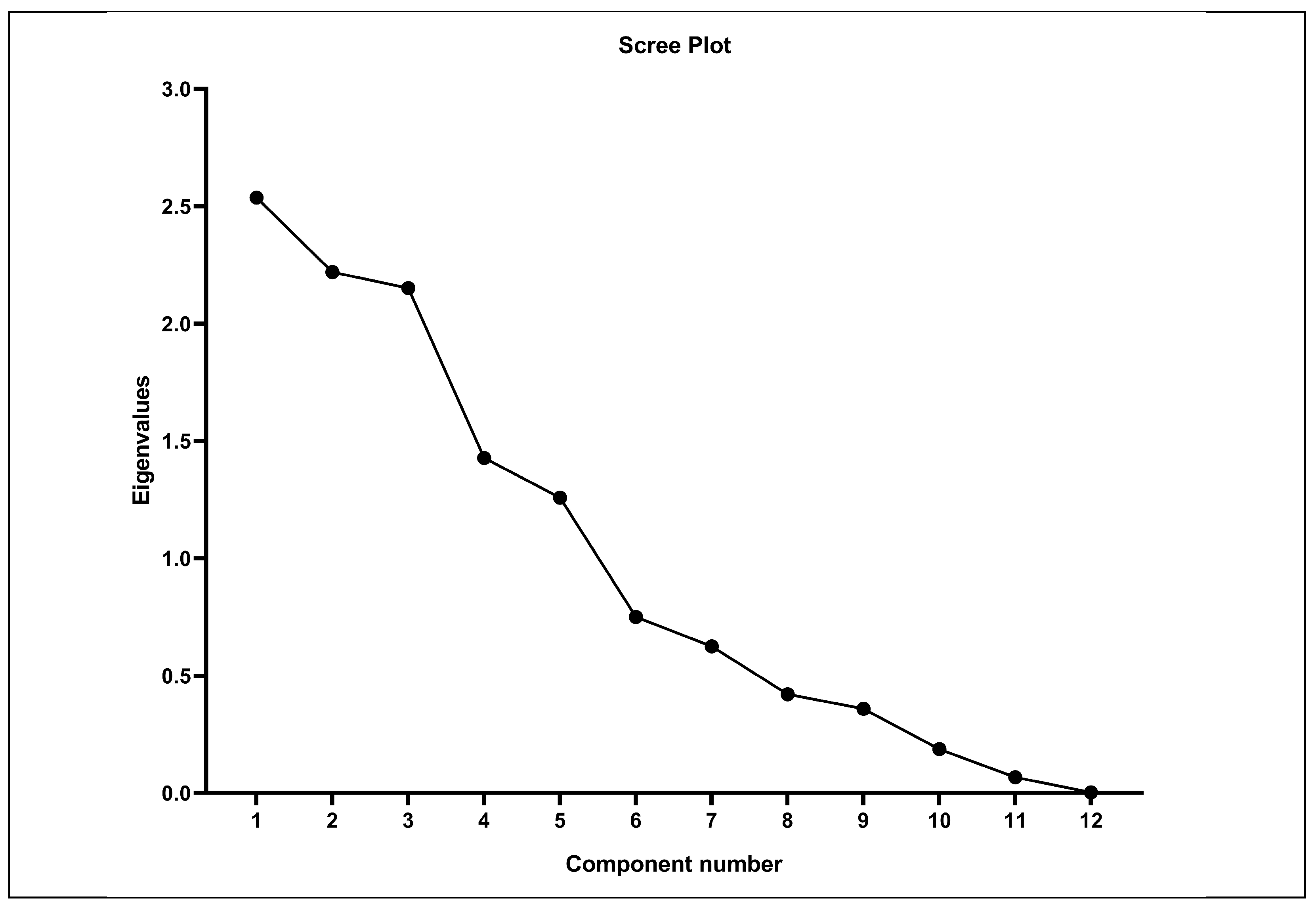
6. Factor Analysis (PCA)

Principal component analysis and factor analysis were performed on eleven parameters. Table 3 lists eigenvalues, aiding dimension reduction and component quality assessment in PCA. Scree plot analysis is conducted to determine the optimal number of principal components and variables selection to retain sufficient information and simplify the dataset. The scree plot analysis for selection of variables was plotted in Figure 6. It was observed that the slope noticeably flattened after the third variable. For this study, five components or factors were considered (Table 4) using varimax rotation and unrotated factor criterion, focusing on factor classes with eigenvalues greater than one. In the factor loadings of water quality parameters, pH, DO, BOD, and TH cluster together, while TSS, TS, TSS, and turbidity form another cluster, as per the varimax rotation matrix (Figure 7). The first three-factor loadings, preserving 57.26% of the variance in the dataset, indicate the successful capture of a substantial portion of the data’s variability by PCA. The first principal component, accounting for 21.12% of the total variance, exhibited substantial positive loadings on TSS (0.77), TS (0.56), BOD (0.54), and TA (0.56), while showing a minimal contribution from DO (0.27), pH (0.29), and ORP (0.38) to the samples. This category represents anthropogenic controls. While TSS, TS are associated with human-induced sources such as agricultural discharge, runoff containing sediment, and pollutants, which can lead to increased TDS and TS in the water body. Factor 2, explaining 18.49% of the total variance, demonstrated significant positive loadings for turbidity (0.80), TS (0.79), and TSS (0.60). Turbidity affects the clarity of water and is typically caused by particles such as silt, clay, and organic matter. High turbidity can reduce the penetration of light in water and disrupt aquatic ecosystems, and it has significant negative factor loadings for pH (0.26), BOD (0.04), DO (0.20), alkalinity (0.16), and hardness (0.05). Factor 3, accounting for 17.93% of the total variance, exhibited significant loadings for pH, BOD, and alkalinity, while showing negative loadings for ORP, total suspended solids (TSS), and total alkalinity (TA) in the water. Moreover, Factor 5, representing 11.16% of the total variance, and significant loadings were observed on TDS and DO. This factor class is a typical characteristic of geogenic influence. These parameters indicate the similar causes of anthropogenic influences, likely associated with factors such as solid waste contamination and surface runoff with organic contains. However, negative loadings for pH, EC, BOD, and TSS among the samples. It was observed that the same association between pH, TSS, TDS, and TS was also captured by the PCA in the first component class. This further indicates that they have significantly influenced each other in the waters. Moreover, the second subgroup component class showed high loadings on DO, BOD, and turbidity. The occurrence of these two parameters in the same class is indicative of similar anthropogenic inputs such as solid wastes and contains high organic substances in the water.

7. Spatial Homogeneity and Grouping by HCA Approach

HCA is used for grouping variables into different clusters based on their homogeneity. It is an exploratory data analysis tool for organizing observed datasets into meaningful clusters based on the combination of variables. In the present study, HCA was performed based on Ward linkages and squared Euclidean distance. This clustering analysis provides insights into the similarities between the sample sites, helping to identify patterns and relationships within the dataset. The result is represented by a dendrogram. In the present study, 24 samples were classified into three subgroups (Figure 8). Many samples are clustered in the first group. This group is associated with sample sites 07, 15, 14, 11, 02, 18, 16, 01, 05, and 17 (subgroup 1). The study suggests that the locations have similar characteristics and attributes with respect to water quality. While low spatial homogeneity indicates differences between the locations. Identifying spatial homogeneity can help in understanding the consistency or variability of certain parameters across a study area. A similar approach has been successfully applied to the assessment of water quality by [40,56,57,58].

8. Conclusions

A comprehensive assessment of water quality in Rudrasagar Lake, the Ramsar site in Tripura, has revealed extensive insights into its current ecological health and the factors affecting it. This study depicted the significant impact of human activities on lake water quality. Effluent discharges from residential areas along the lake, agricultural practices, and tourism have been identified as major contributors to changes in water quality. This study looked into eleven parameters that influence the occurrence and level of pollution of lake water. The sampling sites were divided into good, moderate, bad, and very poor concentrations based on the information provided from the statistical simulations. The study shows most sampling sites have high concentrations while a lesser percentage of the sample has a low concentration of variables. The findings of the study abundantly showed that the overall water quality of the lake is unsuitable for drinking and domestic use. Minor variations in the physical properties at the sampling sites near to the inflow source were observed, but the inflow water did not have an influence on the physio-chemical properties of the water body. The findings state that effective conservation and management strategies are needed to improve the ecological integrity and ecological diversity of this particular internationally important study area. These measures are essential to ensure the sustainable well-being of these valuable ecosystems and the long-term sustainability of surrounding communities.

9. Limitation of the Study

In water quality analysis, limitations often arise from data availability. The nature of the study is spatial while temporal variability is not incorporated in this study, modeling complexity. Nutrient analysis and elemental analysis were not possible during the study, which is a shortcoming of this research. Water quality could be incorporated for the betterment of the study and it will be a future aim at this study site. To overcome these limitations and advance the field, future studies should prioritize long-term monitoring, data integration from various sources, the development of advanced sensors, interdisciplinary collaboration, and improvement in machine learning models. Additionally, addressing climate change adaptation, public awareness, policy and regulation, ecosystem-based approaches, and environmental justice considerations are crucial for comprehensive and effective water quality research and management.

Author Contributions

All authors were actively involved in the research process and shared responsibility for its execution and outcomes. P.D. conceptualized and prepared the initial draft of the manuscript, S.R. was responsible for developing the methodology, conducting geospatial mapping, and performing formal data analysis, S.B. assisted in the sampling process and data curation, S.H. and H.N. provided critical review and editing for the article, S.M. formulated the research plan and conducted a comprehensive review of the manuscript. A.-M.C. contributed to the editing for the article, visualization aspects of the research and played a role in funding acquisition. All authors have meticulously reviewed both the results and discussion sections and agreed to the published version of the manuscript.

Funding

The Department of Biotechnology (DBT), NER-BPMC, Govt. of India, provided financial support for this study (Sanction No.: BT/PR25459/NER/95/1341/2017 dated 14 October 2019).

Data Availability Statement

Data are contained within the article.

Acknowledgments

The authors highly acknowledge Punarbasu Chaudhuri, in the Department of Environmental Science, University of Calcutta, India, for his invaluable assistance in laboratory analysis. The authors and monitoring also acknowledge Arpita Biswas, Junior Research Fellow, DBT Sponsored Project, Government of India, for her valuable support during the drafting of the manuscript.

Conflicts of Interest

The authors have declared that there are no conflict of interest in the manuscript, and they ensured that their research activities did not have any adverse impact on the environment during the study period.

References

  1. Brraich, O.S.; Jangu, S. Evaluation of Water Quality Pollution Indices for Heavy Metal Contamination Monitoring in the Water of Harike Wetland (Ramsar Site), India. Int. J. Sci. Res. Publ. 2015, 5, 1–6. [Google Scholar]
  2. Githaiga, K.B.; Njuguna, S.M.; Gituru, R.W.; Yan, X. Water Quality Assessment, Multivariate Analysis and Human Health Risks of Heavy Metals in Eight Major Lakes in Kenya. J. Environ. Manag. 2021, 297, 113410. [Google Scholar] [CrossRef] [PubMed]
  3. Horvat, M.; Horvat, Z.; Pastor, K. Multivariate Analysis of Water Quality Parameters in Lake Palic, Serbia. Environ. Monit. Assess. 2021, 193, 410. [Google Scholar] [CrossRef] [PubMed]
  4. Boyacioglu, H.; Boyacioglu, H. Water Pollution Sources Assessment by Multivariate Statistical Methods in the Tahtali Basin, Turkey. Environ. Geol. 2008, 54, 275–282. [Google Scholar] [CrossRef]
  5. Najar, I.A.; Khan, A.B. Assessment of Water Quality and Identification of Pollution Sources of Three Lakes in Kashmir, India, Using Multivariate Analysis. Environ. Earth Sci. 2012, 66, 2367–2378. [Google Scholar] [CrossRef]
  6. Prasanna, M.V.; Praveena, S.M.; Chidambaram, S.; Nagarajan, R.; Elayaraja, A. Evaluation of Water Quality Pollution Indices for Heavy Metal Contamination Monitoring: A Case Study from Curtin Lake, Miri City, East Malaysia. Environ. Earth Sci. 2012, 67, 1987–2001. [Google Scholar] [CrossRef]
  7. Varekar, V.; Karmakar, S.; Jha, R.; Ghosh, N.C. Design of Sampling Locations for River Water Quality Monitoring Considering Seasonal Variation of Point and Diffuse Pollution Loads. Environ. Monit. Assess. 2015, 187, 376. [Google Scholar] [CrossRef]
  8. Yang, Y.-H.; Zhou, F.; Guo, H.-C.; Sheng, H.; Liu, H.; Dao, X.; He, C.-J. Analysis of Spatial and Temporal Water Pollution Patterns in Lake Dianchi Using Multivariate Statistical Methods. Environ. Monit. Assess. 2010, 170, 407–416. [Google Scholar] [CrossRef]
  9. Jahin, H.S.; Abuzaid, A.S.; Abdellatif, A.D. Using Multivariate Analysis to Develop Irrigation Water Quality Index for Surface Water in Kafr El-Sheikh Governorate, Egypt. Environ. Technol. Innov. 2020, 17, 100532. [Google Scholar] [CrossRef]
  10. Rakotondrabe, F.; Ndam Ngoupayou, J.R.; Mfonka, Z.; Rasolomanana, E.H.; Nyangono Abolo, A.J.; Ako Ako, A. Water Quality Assessment in the Bétaré-Oya Gold Mining Area (East-Cameroon): Multivariate Statistical Analysis Approach. Sci. Total Environ. 2018, 610–611, 831–844. [Google Scholar] [CrossRef]
  11. Tibebe, D.; Zewge, F.; Lemma, B.; Kassa, Y. Assessment of Spatio-Temporal Variations of Selected Water Quality Parameters of Lake Ziway, Ethiopia Using Multivariate Techniques. BMC Chem. 2022, 16, 11. [Google Scholar] [CrossRef] [PubMed]
  12. Zhang, Z.-M.; Zhang, F.; Du, J.-L.; Chen, D.-C. Surface Water Quality Assessment and Contamination Source Identification Using Multivariate Statistical Techniques: A Case Study of the Nanxi River in the Taihu Watershed, China. Water 2022, 14, 778. [Google Scholar] [CrossRef]
  13. Chow, M.F.; Shiah, F.K.; Lai, C.C.; Kuo, H.Y.; Wang, K.W.; Lin, C.H.; Chen, T.Y.; Kobayashi, Y.; Ko, C.Y. Evaluation of Surface Water Quality Using Multivariate Statistical Techniques: A Case Study of Fei-Tsui Reservoir Basin, Taiwan. Environ. Earth Sci. 2016, 75, 6. [Google Scholar] [CrossRef]
  14. Pejman, A.H.; Bidhendi, G.R.N.; Karbassi, A.R.; Mehrdadi, N.; Bidhendi, M.E. Evaluation of Spatial and Seasonal Variations in Surface Water Quality Using Multivariate Statistical Techniques. Int. J. Environ. Sci. Technol. 2009, 6, 467–476. [Google Scholar] [CrossRef]
  15. Zelenakova, M.; Purcz, P.; Pintilii, R.-D.; Blistan, P.; Hlustik, P.; Oravcova, A.; Hashim, M.A. Spatio-Temporal Variations in Water Quality Parameter Trends in River Waters. Rev. Chim. 2018, 69, 2940–2952. [Google Scholar] [CrossRef]
  16. Zhang, X.; Wang, Q.; Liu, Y.; Wu, J.; Yu, M. Application of Multivariate Statistical Techniques in the Assessment of Water Quality in the Southwest New Territories and Kowloon, Hong Kong. Environ. Monit. Assess. 2011, 173, 17–27. [Google Scholar] [CrossRef] [PubMed]
  17. Kukrer, S.; Mutlu, E. Assessment of Surface Water Quality Using Water Quality Index and Multivariate Statistical Analyses in Saraydüzü Dam Lake, Turkey. Environ. Monit. Assess. 2019, 191, 71. [Google Scholar] [CrossRef]
  18. Kumarasamy, P.; Arthur James, R.; Dahms, H.-U.; Byeon, C.-W.; Ramesh, R. Multivariate Water Quality Assessment from the Tamiraparani River Basin, Southern India. Environ. Earth Sci. 2014, 71, 2441–2451. [Google Scholar] [CrossRef]
  19. Phung, D.; Huang, C.; Rutherford, S.; Dwirahmadi, F.; Chu, C.; Wang, X.; Nguyen, M.; Nguyen, N.H.; Do, C.M.; Nguyen, T.H.; et al. Temporal and Spatial Assessment of River Surface Water Quality Using Multivariate Statistical Techniques: A Study in Can Tho City, a Mekong Delta Area, Vietnam. Environ. Monit. Assess. 2015, 187, 229. [Google Scholar] [CrossRef]
  20. Sharma, M.; Kansal, A.; Jain, S.; Sharma, P. Application of Multivariate Statistical Techniques in Determining the Spatial Temporal Water Quality Variation of Ganga and Yamuna Rivers Present in Uttarakhand State, India. Water Qual. Expo. Health 2015, 7, 567–581. [Google Scholar] [CrossRef]
  21. Koklu, R.; Sengorur, B.; Topal, B. Water Quality Assessment Using Multivariate Statistical Methods—A Case Study: Melen River System (Turkey). Water Resour. Manag. 2010, 24, 959–978. [Google Scholar] [CrossRef]
  22. Varol, M.; Şen, B. Assessment of Surface Water Quality Using Multivariate Statistical Techniques: A Case Study of Behrimaz Stream, Turkey. Environ. Monit. Assess. 2009, 159, 543–553. [Google Scholar] [CrossRef] [PubMed]
  23. Wu, M.-L.; Wang, Y.-S.; Sun, C.-C.; Wang, H.; Dong, J.-D.; Yin, J.-P.; Han, S.-H. Identification of Coastal Water Quality by Statistical Analysis Methods in Daya Bay, South China Sea. Mar. Pollut. Bull. 2010, 60, 852–860. [Google Scholar] [CrossRef] [PubMed]
  24. Zhou, F.; Liu, Y.; Guo, H. Application of Multivariate Statistical Methods to Water Quality Assessment of the Watercourses in Northwestern New Territories, Hong Kong. Environ. Monit. Assess. 2007, 132, 1–13. [Google Scholar] [CrossRef]
  25. Tiwari, A.K.; Singh, A.K.; Singh, A.K.; Singh, M.P. Hydrogeochemical Analysis and Evaluation of Surface Water Quality of Pratapgarh District, Uttar Pradesh, India. Appl. Water Sci. 2017, 7, 1609–1623. [Google Scholar] [CrossRef]
  26. Agbasi, J.C.; Egbueri, J.C. Intelligent soft computational models integrated for the prediction of potentially toxic elements and groundwater quality indicators: A case study. J. Sediment. Environ. 2023, 8, 57–79. [Google Scholar] [CrossRef]
  27. Egbueri, J.C.; Unigwe, C.O.; Agbasi, J.C.; Nwazelibe, V.E. Indexical and artificial neural network modeling of the quality, corrosiveness, and encrustation potential of groundwater in industrialized metropolises, Southeast Nigeria. Environ. Dev. Sustain. 2022, 25, 14753–14783. [Google Scholar] [CrossRef]
  28. Etuk, M.N.; Igwe, O.; Egbueri, J.C. An integrated geoinformatics and hydrogeological approach to delineating groundwater potential zones in the complex geological terrain of Abuja, Nigeria. Model. Earth Syst. Environ. 2023, 9, 285–311. [Google Scholar] [CrossRef]
  29. Gautam, V.K.; Pande, C.B.; Moharir, K.N.; Varade, A.M.; Rane, N.L.; Egbueri, J.C.; Alshehri, F. Prediction of Sodium Hazard of Irrigation Purpose using Artificial Neural Network Modelling. Sustainability 2023, 15, 7593. [Google Scholar] [CrossRef]
  30. Khan, M.Y.A.; ElKashouty, M.; Abdellattif, A.; Egbueri, J.C.; Taha, A.I.; Al Deep, M.; Shaaban, F. Influence of natural and anthropogenic factors on the hydrogeology and hydrogeochemistry of Wadi Itwad Aquifer, Saudi Arabia: Assessment using multivariate statistics and PMWIN simulation. Ecol. Indic. 2023, 151, 110287. [Google Scholar] [CrossRef]
  31. Wang, X.; Yang, W. Water Quality Monitoring and Evaluation Using Remote Sensing Techniques in China: A Systematic Review. Ecosyst. Health Sustain. 2019, 5, 47–56. [Google Scholar] [CrossRef]
  32. Roy, R.; Majumder, M. Assessment of Water Quality Trends in Loktak Lake, Manipur, India. Environ. Earth Sci. 2019, 78, 383. [Google Scholar] [CrossRef]
  33. Perkins, R.G.; Underwood, G.J.C. Gradients of Chlorophyll a and Water Chemistry along an Eutrophic Reservoir with Determination of the Limiting Nutrient by in Situ Nutrient Addition. Water Res. 2000, 34, 713–724. [Google Scholar] [CrossRef]
  34. Magyar, N.; Hatvani, I.G.; Székely, I.K.; Herzig, A.; Dinka, M.; Kovács, J. Application of Multivariate Statistical Methods in Determining Spatial Changes in Water Quality in the Austrian Part of Neusiedler See. Ecol. Eng. 2013, 55, 82–92. [Google Scholar] [CrossRef]
  35. Sharma, D.; Kansal, A. Water Quality Analysis of River Yamuna Using Water Quality Index in the National Capital Territory, India (2000–2009). Appl. Water Sci. 2011, 1, 147–157. [Google Scholar] [CrossRef]
  36. Zhao, J.; Fu, G.; Lei, K.; Li, Y. Multivariate Analysis of Surface Water Quality in the Three Gorges Area of China and Implications for Water Management. J. Environ. Sci. 2011, 23, 1460–1471. [Google Scholar] [CrossRef] [PubMed]
  37. Kazi, T.G.; Arain, M.B.; Jamali, M.K.; Jalbani, N.; Afridi, H.I.; Sarfraz, R.A.; Baig, J.A.; Shah, A.Q. Assessment of Water Quality of Polluted Lake Using Multivariate Statistical Techniques: A Case Study. Ecotoxicol. Environ. Saf. 2009, 72, 301–309. [Google Scholar] [CrossRef]
  38. Xu, H.; Yang, L.-Z.; Zhao, G.-M.; Jiao, J.-G.; Yin, S.-X.; Liu, Z.-P. Anthropogenic Impact on Surface Water Quality in Taihu Lake Region, China. Pedosphere 2009, 19, 765–778. [Google Scholar] [CrossRef]
  39. Yang, W.; Zhao, Y.; Wang, D.; Wu, H.; Lin, A.; He, L. Using Principal Components Analysis and IDW Interpolation to Determine Spatial and Temporal Changes of Surface Water Quality of Xin’anjiang River in Huangshan, China. Int. J. Environ. Res. Public Health 2020, 17, 2942. [Google Scholar] [CrossRef]
  40. Mishra, S.; Kumar, A.; Yadav, S.; Singhal, M.K. Assessment of Heavy Metal Contamination in Water of Kali River Using Principle Component and Cluster Analysis, India. Sustain. Water Resour. Manag. 2018, 4, 573–581. [Google Scholar] [CrossRef]
  41. Shine, J.P.; Ika, R.V.; Ford, T.E. Multivariate Statistical Examination of Spatial and Temporal Patterns of Heavy Metal Contamination in New Bedford Harbor Marine Sediments. Environ. Sci. Technol. 1995, 29, 1781–1788. [Google Scholar] [CrossRef] [PubMed]
  42. Tauler, R.; Barcelo, D.; Thurman, E.M. Multivariate Correlation between Concentrations of Selected Herbicides and Derivatives in Outflows from Selected U.S. Midwestern Reservoirs. Environ. Sci. Technol. 2000, 34, 3307–3314. [Google Scholar] [CrossRef]
  43. Noori, R.; Sabahi, M.S.; Karbassi, A.R.; Baghvand, A.; Taati Zadeh, H. Multivariate Statistical Analysis of Surface Water Quality Based on Correlations and Variations in the Data Set. Desalination 2010, 260, 129–136. [Google Scholar] [CrossRef]
  44. Karmakar, B.; Singh, M.K. Assessment of Water Quality Status of Water Bodies Using Water Quality Index and Correlation Analysis in and Around Industrial Areas of West District, Tripura, India. Nat. Environ. Pollut. Technol. 2021, 20, 551–559. [Google Scholar] [CrossRef]
  45. Lodh, R.; Paul, R.; Karmakar, B.; Das, M.K. Physicochemical Studies of Water Quality with Special Reference to Ancient Lakes of Udaipur City, Tripura, India. Int. J. Sci. Res. Publ. 2014, 4, 1–9. [Google Scholar]
  46. Roy, B.; Manna, A.K. The Status of Surface Water in West Tripura District, India: An Approach by Using Water Quality Index and Multivariate Statistical Technique. Asian J. Water Environ. Pollut. 2021, 18, 27–36. [Google Scholar] [CrossRef]
  47. Roy, R.; Majumder, M. Comparison of Surface Water Quality to Land Use: A Case Study from Tripura, India. Desalination Water Treat. 2017, 85, 147–153. [Google Scholar] [CrossRef]
  48. Rostami, A.A.; Isazadeh, M.; Shahabi, M.; Nozari, H. Evaluation of Geostatistical Techniques and Their Hybrid in Modelling of Groundwater Quality Index in the Marand Plain in Iran. Environ. Sci. Pollut. Res. 2019, 26, 34993–35009. [Google Scholar] [CrossRef]
  49. Tukur, A.; Amadi, A. Fluoride Contamination of Shallow Groundwater in Parts of Zango Local Government Area of Katsina State, Northwest Nigeria. J. Geosci. Geomat. 2014, 2, 178–185. [Google Scholar]
  50. Debnath, P.; Roy, S.; Hore, S.; Mitra, S. Mapping of Optimum Freight Route by Using Hybrid VNS Algorithm to Sustain the Economic Viability of a Landslide Prone Area: A Case Study of Tripura. Natl. Acad. Sci. Lett. 2023, 46. [Google Scholar] [CrossRef]
  51. Ouyang, Y. Evaluation of River Water Quality Monitoring Stations by Principal Component Analysis. Water Res. 2005, 39, 2621–2635. [Google Scholar] [CrossRef] [PubMed]
  52. Abir, S. Seasonal Variations in Physico-Chemical Characteristics of Rudrasagar Wetland—A Ramsar Site, Tripura, North East, India. Res. J. Chem. Sci. 2014, 4, 31–40. [Google Scholar]
  53. Pal, M.; Samal, R.N.; Biswas Roy, M.; Roy, P.K. Water Quality Index as a Reliable Indicator of Water Pollution Level-A Case Study of Rudrasagar Lake, Tripura. Int. J. Innov. Res. Sci. Eng. Technol. 2015, 4, 7801–7806. [Google Scholar]
  54. BIS 10500; Drinking Water Specifications. Water Quality Standards. Bureau of Indian Standards (BIS): New Delhi, India, 2012.
  55. Onyemesili, O.O.; Egbueri, J.C.; Ezugwu, C.K. Assessing the pollution status, ecological and health risks of surface waters in Nnewi urban, Nigeria: Implications of poor waste disposal. Environ. Forensics 2022, 23, 346–360. [Google Scholar] [CrossRef]
  56. Filik Iscen, C.; Emiroglu, Ö.; Ilhan, S.; Arslan, N.; Yilmaz, V.; Ahiska, S. Application of Multivariate Statistical Techniques in the Assessment of Surface Water Quality in Uluabat Lake, Turkey. Environ. Monit. Assess. 2008, 144, 269–276. [Google Scholar] [CrossRef]
  57. Hajigholizadeh, M.; Melesse, A.M. Assortment and Spatiotemporal Analysis of Surface Water Quality Using Cluster and Discriminant Analyses. Catena 2017, 151, 247–258. [Google Scholar] [CrossRef]
  58. Kour, G.; Kothari, R.; Dhar, S.; Pathania, D.; Tyagi, V.V. Impact Assessment on Water Quality in the Polluted Stretch Using a Cluster Analysis during Pre- and COVID-19 Lockdown of Tawi River Basin, Jammu, North India: An Environment Resiliency. Energy Ecol. Environ. 2022, 7, 461–472. [Google Scholar] [CrossRef]
Figure 1. Location map and sampling sites of the study area: (a) Indian state of Tripura, (b) Sepahijala District marked within Tripura, (c) relief map of Sepahijala District, and (d) Location of sampling sites (source: prepared by the authors, 2022).
Water 15 04109 g001aWater 15 04109 g001b
Figure 2. Flowchart depicting the procedural steps undertaken throughout the study.
Water 15 04109 g002
Figure 3. Spatial distribution of (a) Temperature; (b) pH; (c) ORP; and (d) EC of the Rudrasagar Lake.
Water 15 04109 g003aWater 15 04109 g003b
Figure 4. Spatial distribution of (a) Total alkalinity; (b) Total hardness; (c) DO; and (d) BOD of the Rudrasagar Lake.
Water 15 04109 g004
Figure 5. Spatial distribution of (a) Turbidity; (b) TDS; (c) TS; and (d) TSS of the Ru-drasagar Lake.
Water 15 04109 g005aWater 15 04109 g005b
Figure 6. Scree plot analysis for optimal variables selection.
Water 15 04109 g006
Figure 7. Factor loadings for Rudrasagar Lake water quality observations based on varimax rotation (loading method: Principal component analysis (PCA).
Water 15 04109 g007
Figure 8. Dendrogram illustrates the similarity and clustering of sampling sites of Rudrasagar Lake.
Water 15 04109 g008
Table 1. Description of sampling sites and their predominantly characterized at Rudrasagar Lake.
Sample IDSample SitesNature and Characteristic LatitudesLongitudesAverage Elevation (m) (MLS)Average Depth (cm)
S1RajghatUsed for recreational activity 23.49589891.31997917.0051.00
S2DevnagarUrban landscape23.49251991.31984619.0053.00
S3Ghrantali MadrasaIndustrial landscape23.49157591.31730418.0055.00
S4BattaliPeriodic market23.49844791.31571117.0049.00
S5ChandanmuraSmall market23.50649591.31134819.00103.00
S6Inner side of the lakeCover residential area23.49824191.32113416.0093.00
S7Inner side of the lakeCover residential area23.50468391.32044117.0065.00
S8Inner side of the lakeBack side of Neermahal23.50708291.31489120.0035.00
S9Inner side of the lakeFerry route 23.50754091.31768519.0043.00
S10Old RangamuraPoultry farming23.50765391.31994318.0039.00
S11LetamuraDaily market23.51083991.31795913.0041.00
S12Yubarajghat Idol immersion 23.51254191.31684717.00158.00
S13Inner side of the lake Ferry route23.50450091.31778824.00100.00
S14Subhashnagar Residential area23.50240991.32015113.00182.00
S15Inner side of the lake Ferry route23.49854991.31804011.00210.00
S16Inner side of the lake Cover agricultural discharge23.49584191.31732612.00221.00
S17IndiranagarIndustrial area23.49394591.31580810.00245.00
S18Inner side of the lake Ferry route23.50198791.3179779.00298.00
S19Inner side of the lake Jak fishing ground23.50450191.3150238.00218.00
S20Chandanmura sanshanghatNear Cremation 23.50223591.3132039.00197.00
S21Inner side of the lake Jak fishing ground23.50180691.31494113.00182.00
S22Inner side of the lake Jak fishing ground23.50454991.31232210.00245.00
S23Dashamir GhatIndol immersion23.51097491.3146419.00210.00
S24Chauhan BasatiResidential area23.51035091.31279912.00158.00
Source: Prepared by the authors using Garmin eTrex 30x handheld GPS, 2021. The abbreviation of MSL is Mean Sea Level.
Table 2. Descriptive statistics of different hydro-chemical parameters of Rudrasagar Lake.
VariablesMin.Max.Range x - σβ2Skp
pH6.37.91.66.90.40.61.3
Temp 27.732.64.830.91.40.2−1.1
EC 51.7350.7299.0132.964.45.01.9
ORP 90.4136.746.3116.613.9−0.9−0.2
TDS 100.0300.0200.0158.468.2−0.70.8
TSS 9.0762.0753.098.2150.618.04.0
Turb8.32119.00110.6836.3835.151.331.64
TS 126.0862.0736.0259.1145.113.63.3
BOD 0.53.22.71.70.9−1.60.3
DO 0.26.96.71.81.39.22.6
TA 70.0190.0120.0151.031.00.1−1.0
TH 67.2169.0101.898.325.60.91.0
All units are mg/L except Temperature (°C), ORP (mV), EC (μS/cm), and Turbidity (NTU).
Table 3. Pearson’s correlation matrix for water quality parameters in Rudrasagar Lake.
pHTempECORPTDSTSSTurbTSBODDOTATH
pH1
Temp−0.221
EC−0.170.291
ORP0.51 *0.14−0.111
TDS−0.14−0.040.34−0.31
TSS0.070.12−0.270.28−0.281
Turb−0.120.220.29−0.390.43 *0.271
TS−0.010.13−0.120.170.170.90 **0.47 *1
BOD0.50 *−0.17−0.09−0.07−0.220.36−0.030.241
DO−0.050.43 *−0.010.020.040.03−0.080.030.49 *1
TA0.14−0.12−0.40.32−0.140.25−0.310.2−0.070.051
TH0.16−0.120.29−0.01−0.05−0.030.06−0.050.340.24−0.221
* Correlation is significant at the 0.05 level (2-tailed). ** Correlation is significant at the 0.01 level (2-tailed). All units are mg/L except Temp (°C), ORP (mV), EC (μS/cm), and Turbidity (NTU). Statistically Significant positive relations show in orange colour, negative relative are shown in red. Green colour indicates strong positive linear relationship.
Table 4. Factor loadings for Rudrasagar Lake water quality observations (varimax rotation).
Component% of VarianceCumulative %
12345
pH0.29−0.260.56−0.55−0.3521.1221.14
Temp.−0.210.49−0.370.08−0.5618.4939.63
EC−0.620.290.220.40−0.1417.9357.56
ORP0.380.00−0.610.610.0211.9069.45
TDS−0.500.370.20−0.150.5710.4879.94
TSS0.770.60−0.010.02−0.106.2586.19
Turb.−0.240.800.31−0.150.105.2091.38
TS0.560.790.06−0.050.153.5194.89
BOD0.54−0.040.680.17−0.202.9897.87
DO0.27−0.200.490.450.511.5599.42
TA0.56−0.16−0.37−0.210.270.5699.98
TH−0.02−0.060.560.52−0.250.02100.00
Extraction Method: Principal Component Analysis with 5 components extracted. Bold values indicate statistically significant results.
Disclaimer/Publisher’s Note: The statements, opinions and data contained in all publications are solely those of the individual author(s) and contributor(s) and not of MDPI and/or the editor(s). MDPI and/or the editor(s) disclaim responsibility for any injury to people or property resulting from any ideas, methods, instructions or products referred to in the content.

