
Evaluating Hydrological Drought Risk in Lithuania

1
Laboratory of Hydrology, Lithuanian Energy Institute, 44403 Kaunas, Lithuania
2
Department of Digital Technologies in Energy, Institute of Nuclear and Thermal Energy, 03056 Kyiv, Ukraine
*
Author to whom correspondence should be addressed.
Water 2023, 15(15), 2830; https://doi.org/10.3390/w15152830
Submission received: 26 June 2023
/
Revised: 26 July 2023
/
Accepted: 3 August 2023
/
Published: 4 August 2023
(This article belongs to the Section Water and Climate Change)
Abstract
:Hydrological drought poses a major global challenge, exacerbated by climate change and increasing water demand, leading to water scarcity, environmental degradation, and socioeconomic impacts. Thereby, there is a need for comprehensive methods to assess and predict hydrological droughts. The methodology part was based on the calculation of hydrological drought risk components—hazard and vulnerability—according to the equal weight scale of each variable. The spatial distribution of point values was performed by the inverse distance weighting interpolation method. To calculate indices, the spatial layer overlapping of variables was performed using the Raster Calculator tool. Statistical tools were used to estimate drought risk in river catchments. As a result, three main maps were prepared: The hydrological drought hazard index, the hydrological drought vulnerability index, and the hydrological drought risk. These maps highlight regional variations in drought hazards, vulnerability, and risk. Hazard and risk index values are higher in the northern part of Lithuania and lower in the south. The central region exhibits the highest percentage of areas at high and very high risk; the western region shows less risk due to a maritime climate; and the Southeastern region demonstrates the lowest susceptibility to hydrological drought due to physical-geographical factors.
1. Introduction
Drought is a pressing issue in the modern world. This phenomenon is widely known because it can occur in any climate region worldwide [1,2,3,4]. Climate change, which is largely induced by humans, contributes to an increase in the frequency and severity of extreme weather events, including droughts [4,5,6,7]. Due to population growth, the water demand and deficit have been considerably increasing [7,8], and even though the drought has been with humanity for a long time, there is still a lack of necessary methods for assessing and predicting droughts [3].
Generally, four types of droughts are distinguished: Meteorological, agricultural, hydrological, and socioeconomic. The first three types of droughts generally have a cascading effect, as the lack of precipitation leads to decreased soil moisture, followed by decreased runoff [9]. In recent years, there has been a growing interest in developing and applying various methods and techniques for drought assessment, ranging from statistical analyses to sophisticated modeling approaches. Some of these techniques are created for specific types of drought (such as the soil moisture deficit index [10] used for agricultural drought or the standardized streamflow index [11] used for hydrologic drought). Some of them are universal (such as the standardized precipitation index (SPI) [12] or the Palmer drought severity index [13]).
However, it is very important not only to be able to identify drought events but also to understand their causes and the vulnerability of areas to drought in order to minimize the impact of droughts in the future. Ignoring the problem of drought in strategic development plans can have devastating consequences, leading to water scarcity, food insecurity, and economic losses. The economic losses due to a single drought can reach several billion euros [14].
Unlike other natural hazards, droughts do not occur suddenly (often called a “creeping phenomenon”) and can cover large areas for an extended period of time. Therefore, this slow onset and growth give a huge opportunity to prepare to withstand the pressure of drought events [3,15]. Mitigating the direct and indirect social, environmental, and economic impacts of drought through targeted risk reduction and adaptation becomes a global priority [16]. According to the United Nations Secretariat of the International Strategy for Disaster Reduction [17], drought risk is the combination of the natural hazard and the human, social, economic, and environmental vulnerability of a community or country, and managing risk requires understanding these two components and related factors in space and time. The drought hazard component usually consists of evaluating past droughts that have occurred in the studied area and may include indices such as SPI, streamflow drought index (SDI), vegetation condition indices, or an analysis of drought based on certain criteria [18,19,20]. The drought vulnerability component is relatively subjective and shows the degree of impact of a specific event on the system [21]. Drought vulnerability may include an analysis of total gross domestic product (GDP), irrigated lands, agricultural lands, livestock density, population density, proximity to infrastructure, municipal water, and other factors (depending on the goals of the study and the research area) [18,19,20,22]. Changes in both the climate system and socioeconomic processes are essential drivers of the core components (vulnerability, exposure, and hazards) that constitute risk [23].
Overall, the development and application of various methods and techniques are critical for improving the understanding of droughts and their impacts on water resources, as well as for developing effective drought management and adaptation strategies. However, adaptation or increasing resilience to drought should be based on a prior analysis of the territory’s vulnerability [18].
A systematic literature review of existing drought risk assessments made by [16] discovered that most studies applied quantitative or mixed-methods approaches, while qualitative approaches were relatively rare. The same review revealed that, in terms of assessment methodology, more than half of the studies applied index-based approaches. The choice of approach depends on the scale and scope of the assessment.
The creation of a global drought risk map by Carrão et al. [24], covering multiple regions, population groups and economic sectors, was one of the first such attempts to identify where local risk assessments should be conducted to improve drought preparedness and strengthen appropriate drought management policies. This global assessment revealed lower drought risk in remote regions (such as tundras and tropical forests) and higher risk in populated areas extensively exploited for crop production and livestock farming, such as South-Central Asia, the Southeast of South America, Central Europe and the Southeast of the United States. The study at the pan-European scale found that, in general, southeastern Europe and northern Europe (Iceland, Norway, and Finland) are under low drought risk in comparison to the other European regions, whereas parts of maritime Europe and the western Mediterranean show increasing drought risk [25]. Meanwhile, smaller-scale studies identify drought risk zones in regions of individual countries. For example, an analysis conducted in Turkey revealed seven administrative provinces at moderate to high risk of drought out of 81 [20]. The most exposed province was characterized by extensive agricultural and irrigated land. The assessment in Iran also highlighted the unique role of land use in mitigating drought risk and the close relationship between the two [26]. The created risk map indicated that Iran’s central part, northeast, southeast and western areas fall into the high-risk drought class and that the drought risk decreases from the center of Iran to the southwest and northwest. The temporal and spatial patterns of drought risk indicators for the regions of Peninsular Malaysia revealed two districts at moderate drought risk and 35 districts at low hydrological drought risk out of 42, as well as the trend towards dry conditions [19]. Often, the assessments of drought risk are directed to the selected study regions in a single country [27,28,29] or in multiple countries [18] or selected river basins (especially in the case of hydrological drought; [30,31]).
Although there has been an increase in the number of studies devoted to droughts in Lithuania recently [32,33,34,35,36], not a single study has been conducted to assess the risk of droughts and susceptibility to hydrological drought. This work aims to make a risk assessment of hydrological drought using an index-based approach by creating a map based on an integrated assessment of hydrological drought hazards and vulnerabilities. The work focuses entirely on Lithuanian river catchments and will help shape more drought-resistant systems in the future.
2. Materials and Methods
2.1. Study Area and Data
The total study area is 65,200 km2, which corresponds to the entire territory of Lithuania. The area belongs to the plain and includes only four main forms of relief: two highlands (Žemaičiai highland and Baltic highland) and two lowlands (Pajūris lowland and Middle Lithuania lowland). The maximum height above sea level reaches 294 m. The territory of Lithuania belongs to a temperate continental climate with the influence of the Baltic Sea on the coastal areas, which forms a strip of maritime climate. Precipitation ranges from 572 mm/y to 856 mm/y. These physiographic conditions form three main hydrological regions in Lithuania (Figure 1): western (W-LT), central (C-LT), and southeastern (SE-LT).
Despite the small size of Lithuania, it has more than 22,000 rivers with a total length of over 37,000 km identified within its borders. River flow in the summer period ranges from 0.1 × 10⁻³ m3/s·km2 in the C-LT region to 4.7 × 10⁻³ m3/s·km2 in the SE-LT region. River-feeding sources vary from predominant rainfall in the W-LT region to groundwater in the SE-LT region.
For the study, hydrological data from 24 water gauging stations (WGS) were used for the period from 1961 to 2020. Data from 38 meteorological stations that operated during the study period were used to investigate the distribution of precipitation in Lithuania. Daily hydrological and meteorological datasets were obtained from the Lithuanian Hydrometeorological Service. For the overall analysis of Lithuania, 1059 catchments from 19 main Lithuanian basins (Table 1) were taken; two of them were joined due to the small area of one of them (Prieglius river basin connected to Šešupė river basin). SRTM raster with a resolution of 1 arc-second was downloaded from the website: https://earthexplorer.usgs.gov/ (accessed on 21 April 2023). Information about land cover, soils, and lakes was taken from https://www.geoportal.lt/geoportal/ (accessed on 22 April 2023).
2.2. Methods
2.2.1. Data Preparation
As mentioned above, daily water discharge data from 24 WGSs were used for analysis, but two data sets had missing values for measurements. These gaps did not exceed 2% of the total data series length, so it was decided to restore the missing data using two approaches.
If there was another hydrological station on the river, the following equation was used to restore daily discharge data:
where α is the unknown discharge at the gauging station, β is the known discharge at the adjacent station on the respective river, and A is the catchment area for each water gauging station.
If there was no second station on the river, it was decided to select a catchment area similar in size and physiographic characteristics. The next step was to compare the two data sets and use the equation of determination to fill in the missing data.
2.2.2. Drought Risk Calculation
The analysis of hydrological drought risk (HDR) includes two components: Drought hazard and drought vulnerability. This work focused only on water bodies; therefore, socio-economic indicators were not included in the consideration. The general calculation process is depicted in Figure 2.
Thus, the hydrological drought hazard index (HDHI) included four variables for assessing hydrological drought and its dependence on climate:
- Number of hydrological droughts lasting 5–16 days—WSD;
- Number of hydrological droughts lasting more than 16 days—WLD;
- Average precipitation—R;
- Dependence of river runoff on rainfall—RD.
The hydrological drought vulnerability index (HDVI) consisted of the following physico-geographical variables affecting river runoff:
- Slope—S;
- Land use/land cover type—LULC;
- Morphological composition of soils—SL;
- Lake density—L.
The general equation for calculating hydrological drought risk was as follows:
where the first part (WSD + WLD + R + RD)/4 represents the drought hazard index and the second part (S + LULC + SL + L)/4 represents the drought vulnerability index.
2.2.3. Spatial Analysis
Spatial analysis of variables was performed using ArcGIS 10.5 software (ESRI, Redlands, CA, USA, distributed in Lithuania by HNIT-BALTIC). The values of the hydrological drought hazard component indexes were interpolated from the study points across the entire territory of Lithuania using the IDW (inverse distance weighted interpolation) tool. The spatial layers of the drought vulnerability component were also analyzed and reclassified using the Raster Calculator tool in the ArcGIS software. The average value for each catchment was calculated with the Zonal Statistics as Table tool.
Maps of the hydrological drought risk, hazard, and vulnerability were created using the Calculate Field tool based on Equation (2). Further analysis of the catchment areas and calculations of potentially hazardous areas were also carried out using GIS tools.
All classes of HDHI, HDVI and HDR were defined according to the natural breaks (Jenks) method of classification.
2.2.4. Index Calculation Method
Hydrological Drought Hazard Component Indices
- The number of droughts lasting 5–16 days and more than 16 days.
The threshold method was used to calculate these variables. The Q30 index was used as the threshold value and calculated as the average of the smallest 30-day continuous discharge value from May to October for the study period. The next step was to determine the hydrological drought by comparing the daily discharge values with the threshold value. Minimum and maximum thresholds were calculated from the probability curve of drought duration. Daily discharge values less than the threshold (with a duration of 1–4 days) were not considered as they were too short. The threshold between short-term and long-term hydrological droughts was equal to nearly 20% of the probability (16 days). The received results for 24 WGSs during the 60-year period were interpolated and displayed on maps (Figure 3a,b).
- Average precipitation.
The annual precipitation data of 38 meteorological stations were used to analyze average precipitation values. A separate raster of interpolated precipitation values for the territory of Lithuania was constructed for each year. The last step was to use the raster calculator to compute the average value over a 60-year period. The final map is shown in Figure 4a.
- The impact of rainfall regime.
The dependence on the rainfall regime was evaluated by distributing the annual runoff hydrographs into three types of river feeding. A detailed description of the calculation of the rainfall contribution to the total river runoff is presented in one of the previous articles [37]. The map of the river runoff dependence on rainfall feeding is shown in Figure 4b. Extreme values 0 and 1, as well as those close to them, were not used because there are no rivers in Lithuania entirely dependent or entirely independent on rainfall.
Hydrological Drought Vulnerability Component Indices
Raster layers were used to estimate slope, land cover type, soil morphology, and lake density. For each variable, a raster with an already assigned score was created or loaded and then rescaled to a 0–1 scale based on the minimum and maximum values. In the case of the lake density in the catchment, the scale change occurred already after determining the percentage of the lake area for each catchment. The resulting spatial layers for the vulnerability index from the websites Earth Explorer and Geoportal were transformed and displayed on the maps in Figure 5.
2.2.5. Rescaling Sets of Variables
Since all variables at the first stage of analysis had different scales and values, we could not combine them without preliminary processing (Table 2). Thus, it was decided to change the evaluation scales to the same type. Each variable was rescaled according to one of the following two equations:
where Y is the adjusted variable, X is the original variable, Xmin is the minimum observed value of the original variable, Xrange is the difference between the maximum and minimum potential scores of the original variable and n is the upper limit of the rescaled variable. Equation (4) was used when inverse scaling was necessary (e.g., rainfall, where lower rainfall rates corresponded to higher risk).
After rescaling, all variables received the same weight (0–1). Only one exception was made for the variable “Dependence of river runoff on rainfall”, since there is no river in Lithuania that is completely dependent or independent of rainfall, so the minimum and maximum values of this variable do not reach 0 and 1, respectively.
3. Results
3.1. Hydrological Drought Hazard, Vulnerability and Risk at the Lithuanian Scale
After the final merging of the layers, three main maps were obtained: The hydrological drought hazard index (Figure 6a), the hydrological drought vulnerability index (Figure 6b), and the hydrological drought risk (Figure 6c). From the distribution map of the HDHI, it can be seen that two poles are forming: The highest hazard score is observed in the north, while the lowest is in the south. The HDHI map shows similarities with the relief of Lithuania and the location of hydrological regions. The HDVI map reflects slightly different tendencies and does not clearly express significant clusters with the same vulnerability level. Only the northern part of the central hydrological region can be identified as the most homogeneous zone with high vulnerability indicators.
The HDR map shows a more pronounced cluster formation with very high values in the north and an elongated cluster with weak to moderate risk values in the southeast, which basically corresponds to the location of the southeastern hydrological region of Lithuania. These values in the south and east can be explained by the presence of more lakes and forests and the influence of the terrain in that area. On the contrary, the high drought risk values in the north can be attributed to the absence of lakes and forests, low precipitation and, to some extent, the influence of soils. Clayey soils, for example, contribute to lower subsurface flow, which could provide a more constant base flow in dry periods.
From the graph in Figure 7, it is evident that a significant part of Lithuania falls into the categories of high and very high risk (49.8%), while only about 24.4% fall into the categories of low and moderate risk. Another notable observation is the difference in the percentage composition of the HDHI and HDVI classes, which may be related to different variables. In the case of HDHI, the variables have a wider spatial distribution and are less directly influenced by human activity. In contrast, the HDVI variables are less spatially constant and more affected by human activities in both temporal and spatial dimensions, resulting in a less uniform or smooth distribution of variables.
3.2. Hydrological Drought Hazard, Vulnerability and Risk at the Hydrological Regions Scale
Analysis of the HDHI, HDVI, and HDR within the hydrological regions reveals significant heterogeneity among the hydrological regions of Lithuania (Figure 8). The central hydrological region (Figure 8b) has the highest percentage of areas at high and very high risk, accounting for 65.1% for HDHI, 88.6% for HDVI, and 72.7% for HDR. In comparison, the percentage of the region in the low and moderate-risk classes is 12.2% for HDHI, 1.5% for HDVI (with a complete absence of the low-risk class), and 6.0% for HDR.
The western hydrological region (Figure 8a) has less area at high and very high risk: 36.2% for HDHI, 77.0% for HDVI, and 61.1% for HDR. The smaller risk is primarily associated with the influence of a maritime climate and precipitation, which create less favorable conditions for drought occurrence. However, the low and moderate-risk classes are also nearly absent, with only 4.2% for HDHI (with a complete absence of the low-risk class), 4.6% for HDVI, and 5.7% for HDR.
In contrast to the other two hydrological regions, the southeastern hydrological region has the lowest susceptibility to hydrological drought (Figure 8c). For example, the area of low and moderate-risk classes accounts for 83.3% for HDHI, 18.6% for HDVI, and 61.3% for HDR. At the same time, the percentage of high and very high-risk classes is 2.7% for HDHI (with a complete absence of the very high-risk class), 52.5% for HDVI, and 10.4% for HDR. Such index values can be explained by the greater dependence of this region on groundwater resources, as well as a higher percentage of forest cover and the presence of lakes, which enable a more resilient response to the risks of hydrological drought.
3.3. Hydrological Drought Hazard, Vulnerability and Risk at the Basins Scale
According to the drought hazard index within the main basins of Lithuania (Figure 9a), four basins can be identified in the north where a significant percentage of catchments belong to the category of a very high hazard: The Lielupe (100% of the territory), Musa (72.9% of the territory), Nemunelis (45.1% of the territory), and Venta (17.6% of the territory) river basins. In the southeast, there are also four basins with catchments classified as having a low probability of hydrological drought hazard: The Merkys (83.8% of the territory, with 16.2% in the moderate class), the small tributaries of the Nemunas River basin (30.4%—catchments located in the eastern part of the basin), the Zeimena (13.9% of the territory, with the remaining 86.1% classified as moderate), and the Neris (8.3% of the territory) river basins. In the central and western hydrological regions, the dominant catchments fall into the moderate category (the Venta and Minija river basins have over 50% of their territory in this class) and the high hazard category (the Jura, Dubysa, Nevezis, Bartuva, Sventoji rivers, and coastal river basins have over 50% of their territory in this class).
Contrary to the drought hazard index, the drought vulnerability index is less optimistic (Figure 9b). Out of the 18 basins, only two have a percentage of catchments exceeding 30% in the low and moderate vulnerability classes, namely the Zeimena (42.2% of the territory) and Dauguva (32% of the territory) river basins. Three other basins have a relatively high proportion of catchments in the low and moderate vulnerability classes: The Merkys (19.6% of the territory), the Nemunas (13.9% of the territory), and the coastal (13.9% of the territory) river basins. All basins in the western and central hydrological regions of Lithuania consist of catchments, with over 60% belonging to the high and very high vulnerability classes for hydrological drought. The basins with the highest percentage in the high and very high classes include the Bartuva (100% of the territory), Dubysa (93.2% of the territory), and Jura (86% of the territory) river basins.
Analyzing the drought risk index (Figure 9c), it can be observed that the highest risk of hydrological drought occurrence is concentrated in the northern part of the central hydrological region, specifically in the basins of the Lielupe River (89.2% of the territory belongs to the class of very high risk and 10.8% to high risk) and the Musa River (38.7% of the territory belongs to the category of very high risk and 50.6% to high risk). Significant percentages with high-risk values are also found in the basins of the Bartuva, Venta, Nemunelis, Nevezis, Dubysa, Jura, Minija rivers, and coastal rivers. The basins with the lowest risk of hydrological drought are the Merkys (98.1% of the territory belongs to the low and moderate risk classes) and Zeimena (95% of the territory belongs to the low and moderate risk classes) river basins. Overall, there is a significant proportion of catchments with low and moderate risk classes in the southeastern region of Lithuania, with a slight increase in the basins located near the sea. For example, in the basin of the coastal rivers, catchments in the low- and moderate-risk classes account for 13.9% of the total territory.
4. Discussion
Many studies reveal the ineffectiveness of the traditional crisis management approach to the drought phenomenon and the need to move to a drought risk reduction approach instead. It is generally agreed that the costs of proactive drought risk management are lower than the costs of inaction [38]. This is why high-risk areas must be determined to implement risk mitigation measures [39]. The current study was intended to identify for the first time the territories with the highest risk of hydrological drought in Lithuania, down to the catchment scale.
The created methodology for hydrological drought risk assessment in lowland rivers of Lithuania included indices of natural hazards such as the number of short- and long-term hydrological droughts, average precipitation and river runoff dependence on rainfall feeding. This selection of indices was based on the methodologies used in other studies where, regardless of physical-geographical conditions, drought hazard is often assessed using drought indices (SPI, SDI, multivariate standardized drought index, etc.) that in one way or another describe the precipitation deficit or streamflow regime [18,20,26,29]. In the western and central hydrological regions, many river catchments fell into hazard-prone areas, likely due to their dependence on precipitation. Meanwhile, the rivers of the southeastern region get a considerable part (more than half) of their runoff from groundwater, so their annual runoff is more evenly distributed. A small number of long-term drought events and a higher number of catchments assigned to the average hazard index class in the W-LT region (compared with the C-LT) might result from more humid conditions and higher precipitation because of the proximity to the Baltic Sea. The previous studies [37,40] dedicated to the delineation of hydrological regions revealed that the amount of precipitation and the proportional contribution of river-feeding sources are the main factors that determine the particularities of Lithuanian river runoff formation.
According to the physical-geographical factors (watercourse slope, land use/land cover, soils, and lake density) that were expected to affect the susceptibility of Lithuanian river catchments, the SE-LT region emerged as having the lowest index values. A higher abundance of lakes and semi-natural and forested areas might have contributed to a more consistent and stable runoff in the catchments located in this region. In comparison, the C-LT region was distinguished by many areas used for agriculture due to the highest productivity of soils, thus having a higher water demand for irrigation needs. The C-LT and W-LT regions also have more urbanized areas and fewer semi-natural and forested lands than the SE-LT. Unlike [21,26], our study was unable to demonstrate that the region (SE-LT), having a terrain with high slopes (higher than the rest of the country), was more susceptible to drought. In contrast to most studies [21,41,42], in this work, the influence of sandy soils on hydrological drought vulnerability was estimated to be the smallest. The prevailing lighter soils contribute to faster infiltration and retention of subsurface flow in the groundwater layer. The more groundwater recharges, the more resilient rivers become [43,44]. One of the drawbacks of our study is that the selection of variables for vulnerability analysis was limited since it was based mainly on data availability. Such indicators as domestic water supply, population density or groundwater level could give a more accurate assessment of the susceptibility to the impacts of hydrological drought hazards.
According to previous work [36], drought vulnerability indexes on a regional scale are very closely related to drought severity calculated by the SDI index. For both works, the western region can be identified as the most vulnerable region with the most extreme drought values. On the other hand, the SE-LT region has lower severity values compared to other regions, which can be related to fewer catchments with very high vulnerability. In general, hydrological drought hazard and risk indexes also present SE-LT with a lower percentage of very high values.
Unfortunately, we could not find any studies of such scale and detail that reveal the results of similar spatial analyses concerning regional differences in adverse environmental or socio-economic consequences of drought. Only the related outcomes of a few studies concerning agricultural drought were discovered. According to agricultural drought indices (hydrothermal coefficient and temperature–precipitation index), droughts are recorded more often in the western and central parts of Lithuania and less frequently in the southeast and east [45,46].
The catchment-based analysis identified a cluster of high-risk values in the northern part of the C-LT region, specifically in the catchments of the Mūša and Lielupė rivers. This cluster represents the most hazardous area with the highest risk of hydrological drought occurrence in Lithuania. The findings also support previous research [47], which revealed the presence of five intermittent rivers in this most drought-prone area. The study by [48] discovered the highest recurrence of non-precipitation periods of different durations during the warm period in the Middle Lithuanian lowland as well. Considering the scale of the drought assessment, Hasan et al. [19] pointed out that drought characteristics should be evaluated at the catchment level to get better results.
It is worth mentioning the basin of the small tributaries of the Nemunas River separately. This elongated basin spans all three hydrological regions of Lithuania. Its shape provides valuable insights into the variation of drought risk indices from east to west. Consequently, the upper part of the basin exhibits one of the lowest drought risk indices. However, as it approaches the river mouth, the situation changes due to the inflow of tributaries from potentially drier areas of Lithuania. As a result, the middle part of the basin predominantly consists of catchments with high drought risk, while only near the river mouth, several catchments with low and moderate hydrological drought risk become noticeable. This trend is observed for all three indices.
This study covered all river catchments (over a thousand) in Lithuania, making it unique because previous hydrological drought investigations were based only on the selected sets of catchments [35,36,49]. Even though only physical-geographical aspects were analyzed, such a detailed assessment proved that Lithuanian rivers of different hydrological regimes assigned to separate regions have different drought risks. On the other hand, land use indirectly indicates water deficit and demands related to anthropogenic activities. Therefore, including urbanized and agricultural areas in the assessment indirectly represents socio-economic drivers. According to UNISDR [17], unlike meteorological drought, a natural phenomenon resulting from climatic causes that vary from region to region, hydrological drought highly depends on human and social aspects. Many studies demonstrate the decisive influence of an anthropogenic, not a climate, factor in drought risk studies since this phenomenon can occur in any type of climate [5,44,50].
5. Conclusions
The present study evaluated the hydrological drought risk in Lithuanian river catchments. The methodology integrating selected hazard and vulnerability indices was created and proposed as appropriate to be applied to lowland river catchments. The findings indicated that the distribution of catchments according to the drought hazard index generally corresponded well to the hydrological regions of Lithuania. The findings revealed that, in total, over 70% of Lithuania’s territory falls into the categories of high and very high vulnerability, whereas almost half of the country is in high and very high-risk categories (49.8%).
The accomplished research highlights the need for future revisions in territorial planning in the identified most vulnerable catchments in the central and western parts of Lithuania to establish more drought-resistant ecosystems. Future studies should involve assessing socio-economic indicators, such as domestic water supply or population density, to determine water resource consumption. This would help in fully identifying regions with inadequate water resource provisions.
To obtain more reliable results, not only additional drought-sensitive indicators should be included in the assessment of hydrological drought risk, but also a transboundary approach should be applied. River catchments seldom coincide with political borders; therefore, the entire cross-border catchments should be included to obtain a more comprehensive view of the hydrological drought risk problem in Lithuania.
The obtained results are important for understanding how sensitive and vulnerable lowland river systems are becoming in a rapidly changing environment.
Author Contributions
Conceptualization, S.N. and J.K.; methodology, S.N. and V.P.; software, S.N.; formal analysis, S.N.; investigation, S.N. and D.Š.; data curation, J.K. and V.P.; writing—original draft preparation, S.N. and D.Š.; writing—review and editing, D.Š.; visualization, S.N.; supervision, V.P. and J.K. All authors have read and agreed to the published version of the manuscript.
Funding
This research received no external funding.
Data Availability Statement
Not applicable.
Acknowledgments
The authors wish to thank the Lithuanian Hydrometeorological Service for providing the daily precipitation and discharge data.
Conflicts of Interest
The authors declare no conflict of interest.
References
- Wilhite, D.A. Moving toward Drought Risk Management: The Need for a Global Strategy; National Drought Mitigation Center: Lincoln, NE, USA, 1992. [Google Scholar]
- Hayes, M.J.; Svoboda, M.; Wall, N.A.; Widhalm, M. The Lincoln Declaration on Drought Indices: Universal Meteorological Drought Index Recommended. Bull. Am. Meteorol. Soc. 2011, 92, 485–488. [Google Scholar] [CrossRef] [Green Version]
- Hasan, H.H.; Mohd Razali, S.F.; Muhammad, N.S.; Ahmad, A. Research Trends of Hydrological Drought: A Systematic Review. Water 2019, 11, 2252. [Google Scholar] [CrossRef] [Green Version]
- Intergovernmental Panel on Climate Change (IPCC). Summary for Policymakers. In Climate Change 2021: The Physical Science Basis; Contribution of Working Group I to the Sixth Assessment Report of the Intergovernmental Panel on Climate Change; Masson-Delmotte, V., Zhai, P., Pirani, A., Connors, S.L., Péan, C., Berger, S., Caud, N., Chen, Y., Goldfarb, L.M.I., Huang, M., et al., Eds.; Cambridge University Press: Cambridge, UK, 2021. [Google Scholar] [CrossRef]
- Mishra, A.K.; Singh, V.P. A review of drought concept. J. Hydrol. 2010, 391, 202–216. [Google Scholar] [CrossRef]
- Asadieh, B.; Krakauer, N.Y. Global change in streamflow extremes under climate change over the 21st century. Hydrol. Earth Syst. Sci. 2017, 21, 5863–5874. [Google Scholar] [CrossRef] [Green Version]
- United Nations Office for Disaster Risk Reduction (UNDRR). GAR Special Report on Drought 2021; United Nations Office for Disaster Risk Reduction (UNDRR): Geneva, Switzerland, 2021; Available online: https://www.undrr.org/quick/13641 (accessed on 19 June 2023).
- Boretti, A.; Rosa, L. Reassessing the projections of the World Water Development Report. npj Clean Water 2019, 2, 15. [Google Scholar] [CrossRef] [Green Version]
- Engström, J.; Jafarzadegan, K.; Moradkhani, H. Drought Vulnerability in the United States: An Integrated Assessment. Water 2020, 12, 2033. [Google Scholar] [CrossRef]
- Narasimhan, B.; Srinivasan, R. Development and evaluation of Soil Moisture Deficit Index (SMDI) and Evapotranspiration Deficit Index (ETDI) for agricultural drought monitoring. Agric. For. Meteorol. 2005, 133, 69–88. [Google Scholar] [CrossRef]
- Modarres, R. Streamflow drought time series forecasting. Stoch. Environ. Res. Risk Assess. 2007, 21, 223–233. [Google Scholar] [CrossRef]
- McKee, T.B.; Doesken, N.J.; Kleist, J. The Relationship of Drought Frequency and Duration to Time Scales. In Proceedings of the 8th Conference on Applied Climatology, Anaheim, CA, USA, 17–22 January 1993; pp. 179–184. [Google Scholar]
- Palmer, W.C. Meteorologic Drought; Research Paper No. 45; US Department of Commerce: Washington, WA, USA, 1965; pp. 1–58. [Google Scholar]
- European Commission; Joint Research Centre; Cammalleri, C.; Pischke, F.; Masante, D.; Barbosa, P.; Naumann, G.; Spinoni, J.; Erian, W.; Vogt, J.V.; et al. Drought Risk Assessment and Management—A Conceptual Framework; Publications Office of the European Union: Luxembourg, 2018; Available online: https://data.europa.eu/doi/10.2760/057223 (accessed on 11 June 2023).
- Tsakiris, G. Drought Risk Assessment and Management. Water Resour. Manag. 2017, 31, 3083–3095. [Google Scholar] [CrossRef]
- Hagenlocher, M.; Meza, I.; Anderson, C.; Min, A.; Renaud, F.; Walz, Y.; Siebert, S.; Sebesvari, Z. Drought vulnerability and risk assessments: State of the art, persistent gaps, and research agenda. Environ. Res. Lett. 2019, 14, 083002. [Google Scholar] [CrossRef]
- United Nations Secretariat of the International Strategy for Disaster Reduction (UNISDR). Drought Risk Reduction Framework and Practices: Contributing to the Implementation of the Hyogo Framework for Action; United Nations Secretariat of the International Strategy for Disaster Reduction (UNISDR): Geneva, Switzerland, 2009; Available online: https://www.unisdr.org/files/11541_DroughtRiskReduction2009library.pdf (accessed on 22 June 2023).
- Nauditt, A.; Stahl, K.; Rodríguez, E.; Birkel, C.; Formiga-Johnsson, R.M.; Kallio, M.; Ribbe, L.; Baez-Villanueva, O.M.; Thurner, J.; Hann, H. Evaluating tropical drought risk by combining open access gridded vulnerability and hazard data products. Sci. Total Environ. 2022, 822, 153493. [Google Scholar] [CrossRef] [PubMed]
- Hasan, H.H.; Razali, S.F.M.; Muhammad, N.S.; Ahmad, A. Modified Hydrological Drought Risk Assessment Based on Spatial and Temporal Approaches. Sustainability 2022, 14, 6337. [Google Scholar] [CrossRef]
- Dabanli, I. Drought hazard, vulnerability, and risk assessment in Turkey. Arab. J. Geosci. 2018, 11, 538. [Google Scholar] [CrossRef]
- Kalura, P.; Pandey, A.; Chowdary, V.M.; Raju, P.V. Assessment of Hydrological Drought Vulnerability using Geospatial Techniques in the Tons River Basin, India. J. Indian. Soc. Remote Sens. 2021, 49, 2623–2637. [Google Scholar] [CrossRef]
- Khademipour, G.; Saberi Anari, S.M.; Nekoyi Moghadam, M.; Masoudi, A.; Jafari Baghini, R. Comprehensive Assessment and Zonation of Drought Risk and Vulnerability in Kerman Province. Health Emergencies Disasters Q. 2018, 3, 113–120. [Google Scholar] [CrossRef] [Green Version]
- Intergovernmental Panel on Climate Change (IPCC). Emergent risks and key vulnerabilities. In Climate Change 2014: Impacts, Adaptation, and Vulnerability; Part A: Global and Sectoral Aspects; Contribution of Working Group II to the Fifth Assessment Report of the Intergovernmental Panel on Climate Change; Field, C.B., Barros, V.R., Dokken, D.J., Mach, K.J., Mastrandrea, M.D., Bilir, T.E., Chatterjee, M., Ebi, K.L., Estrada, Y.O., Genova, R.C., et al., Eds.; Cambridge University Press: Cambridge, UK, 2014; pp. 1039–1099. [Google Scholar]
- Carrao, H.; Naumann, G.; Barbosa, P. Mapping global patterns of drought risk: An empirical framework based on sub-national estimates of hazard, exposure and vulnerability. Glob. Environ. Chang. 2016, 39, 108–124. [Google Scholar] [CrossRef]
- Blauhut, V.; Stahl, K.; Stagge, J.H.; Tallaksen, L.M.; De Stefano, L.; Vogt, J. Estimating drought risk across Europe from reported drought impacts, drought indices, and vulnerability factors. Hydrol. Earth Syst. Sci. 2016, 20, 2779–2800. [Google Scholar] [CrossRef] [Green Version]
- Heydari Alamdarloo, E.; Khosravi, H.; Nasabpour, S.; Gholami, A. Assessment of drought hazard, vulnerability and risk in Iran using GIS techniques. J. Arid Land 2020, 12, 984–1000. [Google Scholar] [CrossRef]
- Shahid, S.; Behrawan, H. Drought risk assessment in the western part of Bangladesh. Nat. Hazards 2008, 46, 391–413. [Google Scholar] [CrossRef]
- Dayal, K.S.; Deo, R.C.; Apan, A.A. Spatio-temporal drought risk mapping approach and its application in the drought-prone region of south-east Queensland, Australia. Nat. Hazards 2018, 93, 823–847. [Google Scholar] [CrossRef]
- Mens, M.J.P.; van Rhee, G.; Schasfoort, F.; Kielen, N. Integrated drought risk assessment to support adaptive policymaking in the Netherlands. Nat. Hazards Earth Syst. Sci. 2022, 22, 1763–1776. [Google Scholar] [CrossRef]
- Nauditt, A.; Firoz, A.B.M.; Trinh, V.Q.; Fink, M.; Stolpe, H.; Ribbe, L. Hydrological drought risk assessment in an anthropogenically impacted tropical catchment. In Central Vietnam. Land Use and Climate Change Interactions in Central Vietnam; Springer: Singapore, 2017; pp. 223–239. [Google Scholar] [CrossRef]
- Omer, A.; Zhuguo, M.; Yuan, X.; Zheng, Z.; Saleem, F. A hydrological perspective on drought risk-assessment in the Yellow River Basin under future anthropogenic activities. J. Environ. Manag. 2021, 289, 112429. [Google Scholar] [CrossRef] [PubMed]
- Rimkus, E.; Stonevičius, E.; Korneev, V.; Kažys, J.; Valiuškevičius, G.; Pakhomau, A. Dynamics of meteorological and hydrological droughts in the Neman river basin. Environ. Res. Lett. 2013, 8, 045014. [Google Scholar] [CrossRef]
- Rimkus, E.; Stonevicius, E.; Kilpys, J.; Maciulyte, V.; Valiukas, D. Drought identification in the eastern Baltic region using NDVI. Earth Syst. Dyn. 2017, 8, 627–637. [Google Scholar] [CrossRef] [Green Version]
- Stonevičius, E.; Rimkus, E.; Kažys, J.; Bukantis, A.; Kriaučiūniene, J.; Akstinas, V.; Jakimavičius, D.; Povilaitis, A.; Ložys, L.; Kesminas, V.; et al. Recent Aridity Trends and Future Projections in the Nemunas River Basin. Clim. Res. 2018, 75, 143–154. [Google Scholar] [CrossRef]
- Kugytė, G.; Valiuškevičius, G. Identification of Hydrological Droughts in Lithuanian Rivers. Geogr. Edukac. 2021, 9, 87–99. [Google Scholar] [CrossRef]
- Nazarenko, S.; Kriaučiūnienė, J.; Šarauskienė, D.; Jakimavičius, D. Patterns of Past and Future Droughts in Permanent Lowland Rivers. Water 2022, 14, 71. [Google Scholar] [CrossRef]
- Akstinas, V.; Šarauskienė, D.; Kriaučiūnienė, J.; Nazarenko, S.; Jakimavičius, D. Spatial and Temporal Changes in Hydrological Regionalization of Lowland Rivers. Int. J. Environ. Res. 2022, 16, 1. [Google Scholar] [CrossRef]
- European Commission; Joint Research Centre; Cammalleri, C.; Naumann, G.; Mentaschi, L.; Formetta, G.; Forzieri, G.; Gosling, S.; Bisselink, B.; De Roo, A.; et al. Global Warming and Drought Impacts in the EU—JRC PESETA IV Project: Task 7; Publications Office of the European Union: Luxembourg, 2020; Available online: https://data.europa.eu/doi/10.2760/597045 (accessed on 12 June 2023).
- Wilhite, D.A. Drought-Management Policies and Preparedness Plans: Changing the Paradigm from Crisis to Risk Management. In Land Restoration; Elsevier: Amsterdam, The Netherlands, 2016; pp. 443–462. [Google Scholar] [CrossRef]
- Jablonskis, J.; Janukėnienė, R. Change of Lithuanian River Runoff; Science: Vilnius, Lithuania, 1978. (In Lithuanian) [Google Scholar]
- Hoque, M.; Pradhan, B.; Ahmed, N.; Alamri, A. Drought Vulnerability Assessment Using Geospatial Techniques in Southern Queensland, Australia. Sensors 2021, 21, 6896. [Google Scholar] [CrossRef]
- Hoque, M.; Pradhan, B.; Ahmed, N. Assessing drought vulnerability using geospatial techniques in northwestern part of Bangladesh. Sci. Total Environ. 2020, 705, 135957. [Google Scholar] [CrossRef]
- Upadhyay, M.; Sherly, M.A. Multivariate Framework for Integrated Drought Vulnerability Assessment—An Application to India. Int. J. Disaster Risk Reduct. 2023, 85, 103515. [Google Scholar] [CrossRef]
- Sahana, V.; Mondal, A. Evolution of multivariate drought hazard, vulnerability and risk in India under climate change. Nat. Hazards Earth Syst. Sci. 2023, 23, 623–641. [Google Scholar] [CrossRef]
- Valiukas, D. Stichinės sausros ir sausringi laikotarpiai pagal Selianinovo hidroterminį koeficientą (HTK) Lietuvoje 1961–2015 metais. Geol. Geogr. 2017, 3, 101–113. [Google Scholar] [CrossRef] [Green Version]
- Rimkus, E.; Mačiulytė, V.; Stonevičius, E.; Valiukas, D. A revised agricultural drought index in Lithuania. Agric. Food Sci. 2020, 29, 359–371. [Google Scholar] [CrossRef]
- Šarauskienė, D.; Akstinas, V.; Nazarenko, S.; Kriaučiūnienė, J.; Jurgelėnaitė, A. Impact of physico-geographical factors and climate variability on flow intermittency in the rivers of water surplus zone. Hydrol. Process 2020, 34, 4727–4739. [Google Scholar] [CrossRef]
- Ūselytė, J.; Bukantis, A. Mesoclimatic analysis of non-precipitation periods in Lithuania. J. Environ. Eng. Landsc. Manag. 2023, 31, 142–156. [Google Scholar] [CrossRef]
- Nazarenko, S.; Kriaučiūnienė, J.; Šarauskienė, D.; Povilaitis, A. The Development of a Hydrological Drought Index for Lithuania. Water 2023, 15, 1512. [Google Scholar] [CrossRef]
- Wan, W.; Zhao, J.; Li, H.Y.; Mishra, A.; Ruby Leung, L.; Hejazi, M.; Wang, W.; Lu, H.; Deng, Z.; Demissisie, Y.; et al. Hydrological drought in the Anthropocene: Impacts of local water extraction and reservoir regulation in the US. J. Geophys. Res. Atmos. 2017, 122, 11313–11328. [Google Scholar] [CrossRef] [Green Version]
Figure 1.
Map of Lithuania (hydrological regions, main basins, WGS and MS).

Figure 2.
Scheme of the general process of hydrological drought risk calculation.
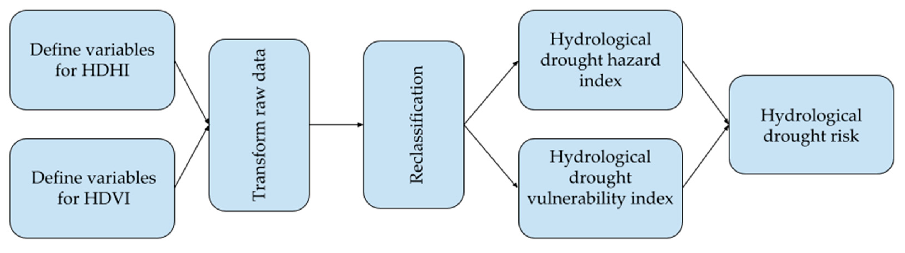
Figure 3.
Map of: (a) number of short drought events; (b) number of long drought events.
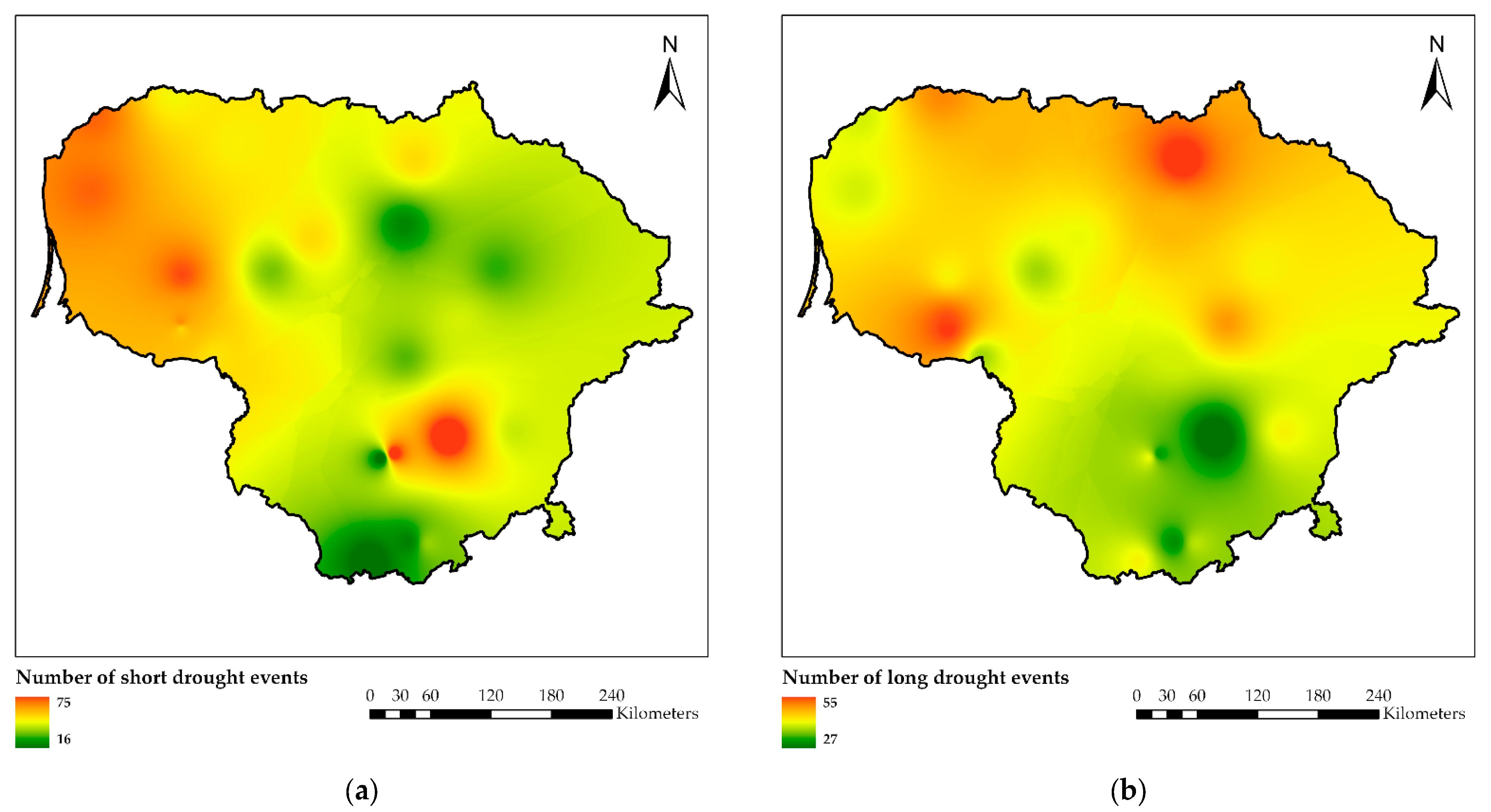
Figure 4.
Map of: (a) average precipitation; (b) river runoff dependence on rainfall-type feeding.

Figure 5.
Map of: (a) slope; (b) land use and land cover; (c) dominant soils; (d) lakes.
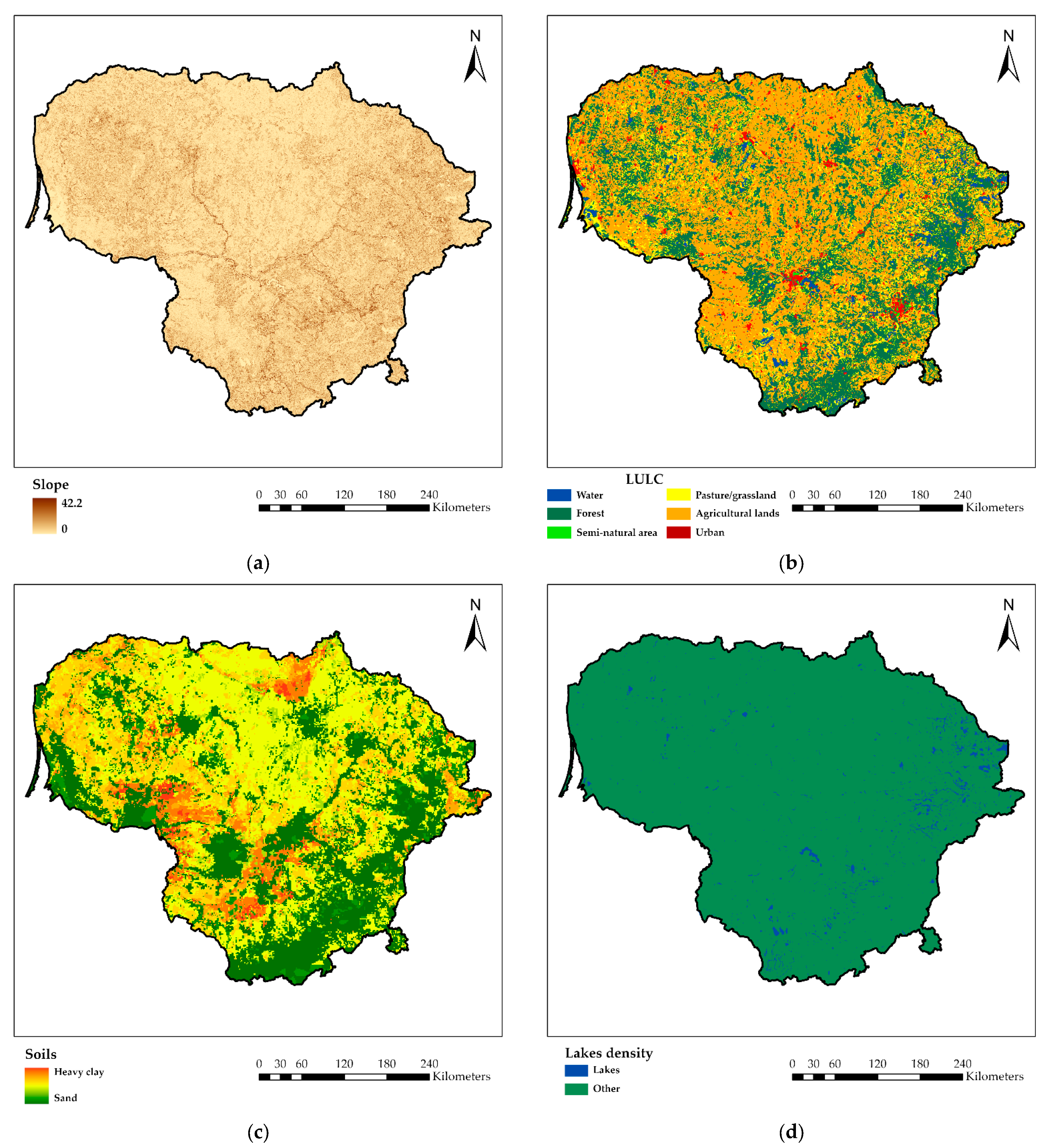
Figure 6.
Hydrological drought hazard index (a); hydrological drought vulnerability index (b); hydrological drought risk map (c).
Figure 6.
Hydrological drought hazard index (a); hydrological drought vulnerability index (b); hydrological drought risk map (c).
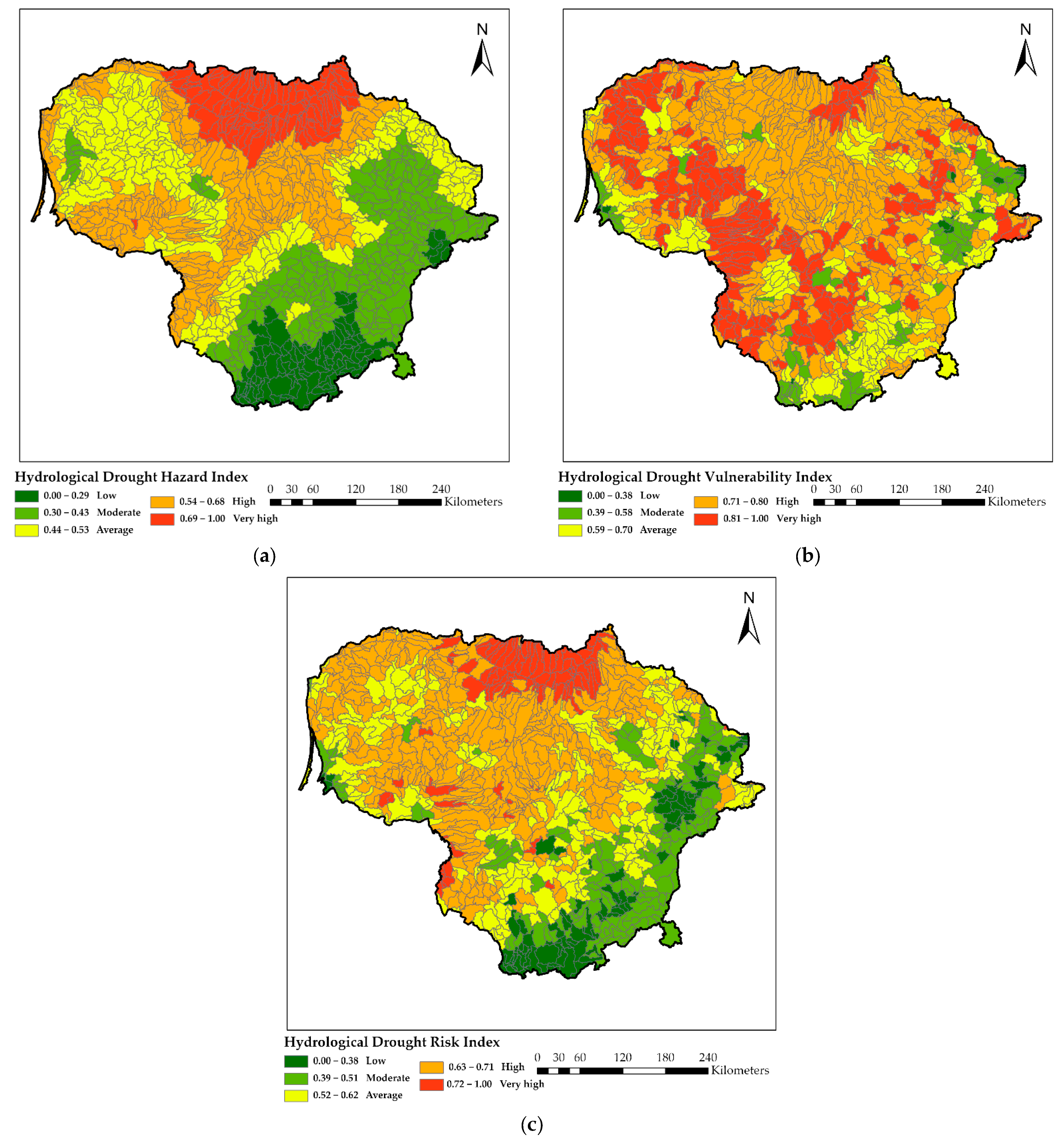
Figure 7.
The composition of the territory in percentages according to hydrological drought hazard index (HDHI); hydrological drought vulnerability index (HDVI); hydrological drought risk index (HDR).
Figure 7.
The composition of the territory in percentages according to hydrological drought hazard index (HDHI); hydrological drought vulnerability index (HDVI); hydrological drought risk index (HDR).

Figure 8.
Distribution of HDHI, HDVI and HDR classes in hydrological regions of Lithuania: western (a); central (b); southeastern (c).
Figure 8.
Distribution of HDHI, HDVI and HDR classes in hydrological regions of Lithuania: western (a); central (b); southeastern (c).
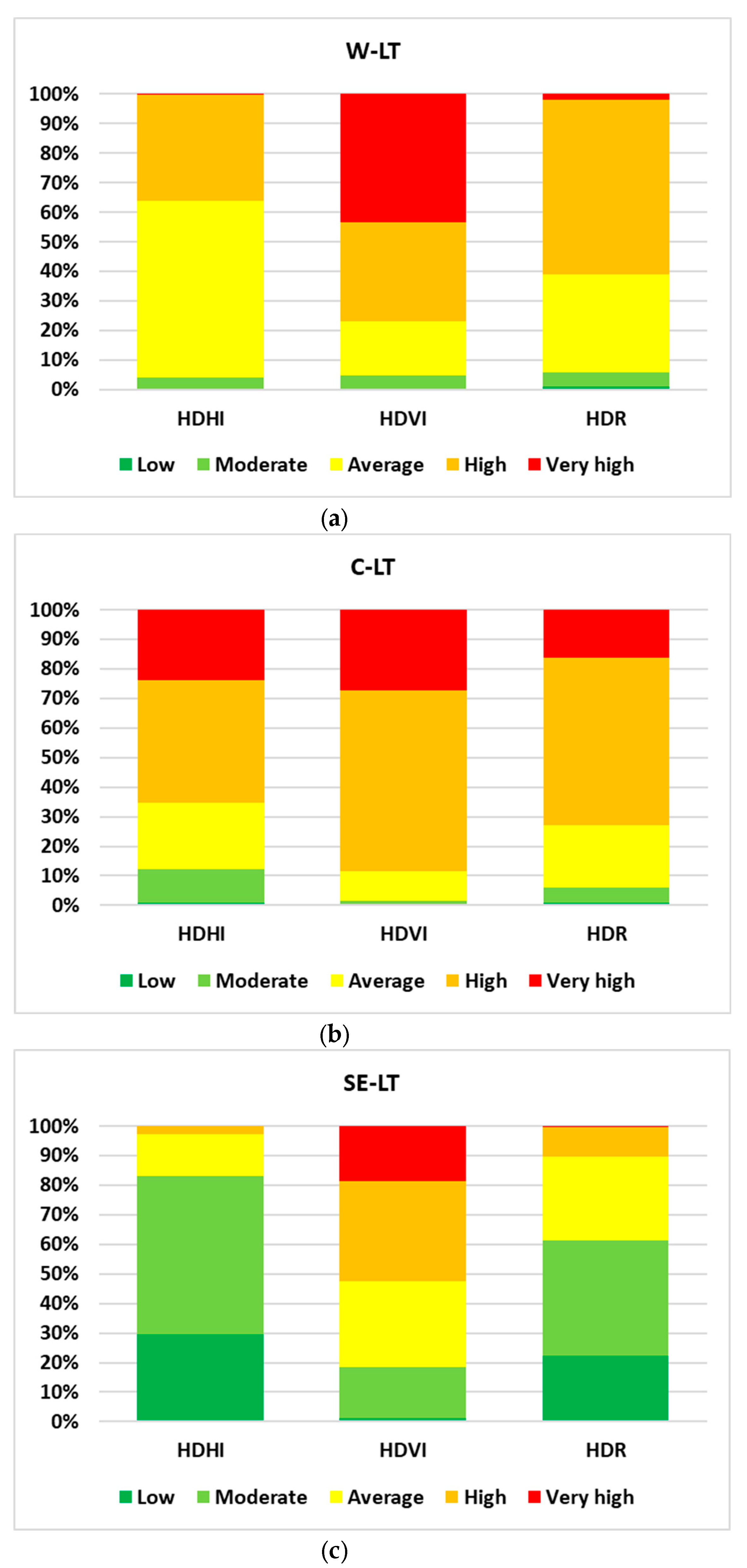
Figure 9.
Distribution of the area of each class in percent for basins, according to: hydrological drought hazard index (a); hydrological drought vulnerability index (b); hydrological drought risk map (c).
Figure 9.
Distribution of the area of each class in percent for basins, according to: hydrological drought hazard index (a); hydrological drought vulnerability index (b); hydrological drought risk map (c).


Table 1.
Characteristics and abbreviation of river basins.
| No. | Basin | Abbreviation | A, km2 |
|---|---|---|---|
| Nemunas river district | |||
| 1. | The small tributaries of the Nemunas river (with the Nemunas river) | SNM | 9294.3 |
| 2. | Merkys river basin | MER | 3781.0 |
| 3. | The small tributaries of the Neris river (with the Neris river) | SNR | 4378.6 |
| 4. | Žeimena river basin | ZEI | 2792.7 |
| 5. | Šventoji river basin | SVE | 6800.7 |
| 6. | Nevėžis river basin | NEV | 6143.8 |
| 7. | Dubysa river basin | DUB | 1972.6 |
| 8. | Jūra river basin | JUR | 3996.6 |
| 9. | Minija river basin | MIN | 2970.9 |
| 10. | Coastal rivers basin | COR | 1100.0 |
| 11. | Šešupė river basin | SSP | 4899.0 |
| 12. | Prieglius river basin | PRG | 88.4 |
| Lielupe river district | |||
| 13. | Mūša river basin | MUS | 5296.7 |
| 14. | Nemunėlis river basin | NML | 1892.0 |
| 15. | The small tributaries of the Lielupe river | SLE | 1749.6 |
| Venta river district | |||
| 16. | Venta river basin | VEN | 5140.4 |
| 17. | Bartuva river basin | BAR | 747.7 |
| 18. | Šventoji river basin | SVT | 398.0 |
| Dauguva river district | |||
| 19. | Dauguva river basin | DUG | 1857.0 |
Note: Small Prieglius river basin was joined to Šešupė river basin for calculation. Basins that merge are highlighted in color.
Table 2.
Primary limits of variables.
| Variable | Limits of the Values Scale | Description |
|---|---|---|
| Number of droughts lasting 5–16 days | 16–75 events | Rescaled before use in GIS |
| Number of droughts lasting more than 16 days | 27–55 events | Rescaled before use in GIS |
| Average rainfall | 572–856 mm/yr | The minimum and maximum annual values in Lithuania were taken as limits for rescaling |
| Dependence of river runoff on rainfall | 0–1 | In Lithuania, the maximum value of the river runoff dependence on the rainfall-type feeding is 0.63, and the minimum value is 0.19 |
| Slope | 0–42.2 | Calculated from SRTM; calculated as an average for a catchment |
| Land use/land cover type | Water—0 Forest—1 Semi-natural area—2 Pasture/grassland—3 Agricultural lands—4 Urban—5 | Calculated as an average for a catchment |
| Morphological composition of soils | Sand—1 ↓ Heavy clay—10 | Given that clayey soils are associated with larger surface runoff and a certain dependence of these soils on the presence of intermittent rivers was revealed in previous work, it was decided to assign them the maximum vulnerability score; calculated as an average for a catchment |
| Lake density | 0–30% | Lake density of 30% percent was taken as 0, as having the least impact on drought vulnerability in the region |
Disclaimer/Publisher’s Note: The statements, opinions and data contained in all publications are solely those of the individual author(s) and contributor(s) and not of MDPI and/or the editor(s). MDPI and/or the editor(s) disclaim responsibility for any injury to people or property resulting from any ideas, methods, instructions or products referred to in the content. |
© 2023 by the authors. Licensee MDPI, Basel, Switzerland. This article is an open access article distributed under the terms and conditions of the Creative Commons Attribution (CC BY) license (https://creativecommons.org/licenses/by/4.0/).
Share and Cite
MDPI and ACS Style
Nazarenko, S.; Šarauskienė, D.; Putrenko, V.; Kriaučiūnienė, J. Evaluating Hydrological Drought Risk in Lithuania. Water 2023, 15, 2830. https://doi.org/10.3390/w15152830
AMA Style
Nazarenko S, Šarauskienė D, Putrenko V, Kriaučiūnienė J. Evaluating Hydrological Drought Risk in Lithuania. Water. 2023; 15(15):2830. https://doi.org/10.3390/w15152830
Chicago/Turabian StyleNazarenko, Serhii, Diana Šarauskienė, Viktor Putrenko, and Jūratė Kriaučiūnienė. 2023. "Evaluating Hydrological Drought Risk in Lithuania" Water 15, no. 15: 2830. https://doi.org/10.3390/w15152830
Note that from the first issue of 2016, this journal uses article numbers instead of page numbers. See further details here.