A Modified Empirical Retracker for Lake Level Estimation Using Cryosat-2 SARin Data


Abstract
:1. Introduction
2. Study Areas and Data
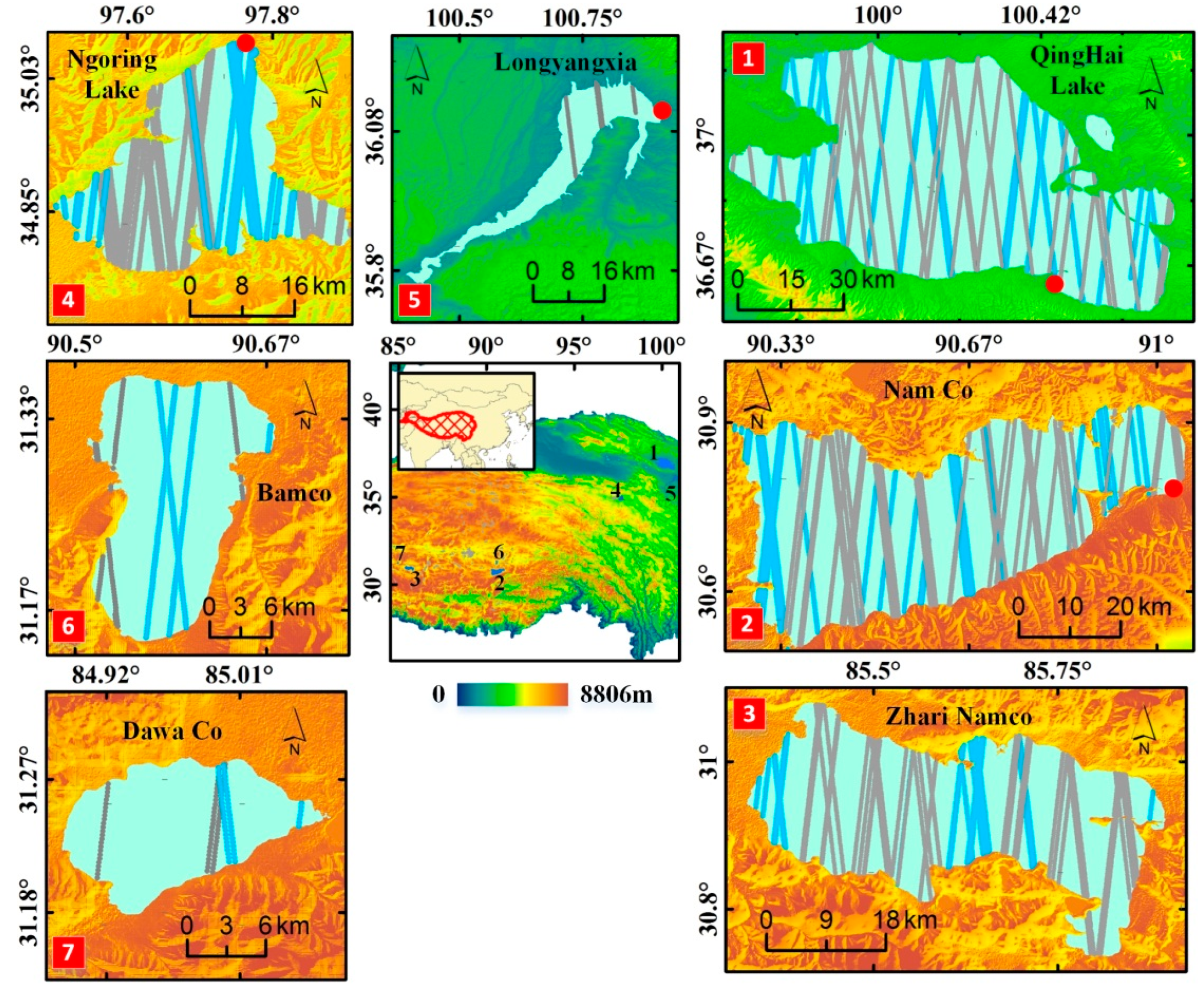
2.1. Study Areas
2.2. Data
2.2.1. Water Mask: The 2014 Sub-Dataset
2.2.2. Cryosat-2 SARin Data
2.2.3. In Situ Data
3. Methods
3.1. Estimation of Lake Level
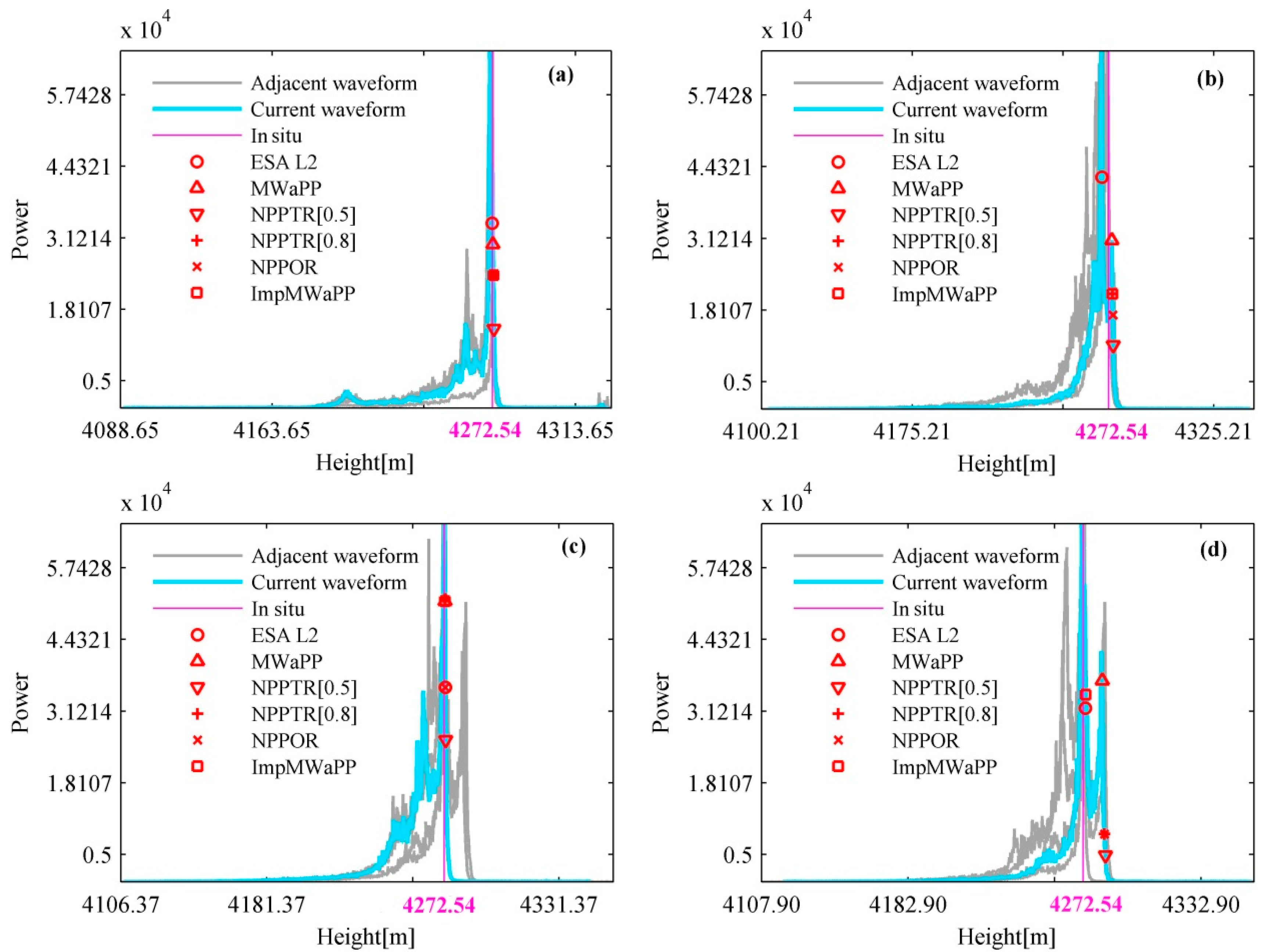
3.2. Improved Multiple Waveform Persistent Peak Retracker (ImpMWaPP)
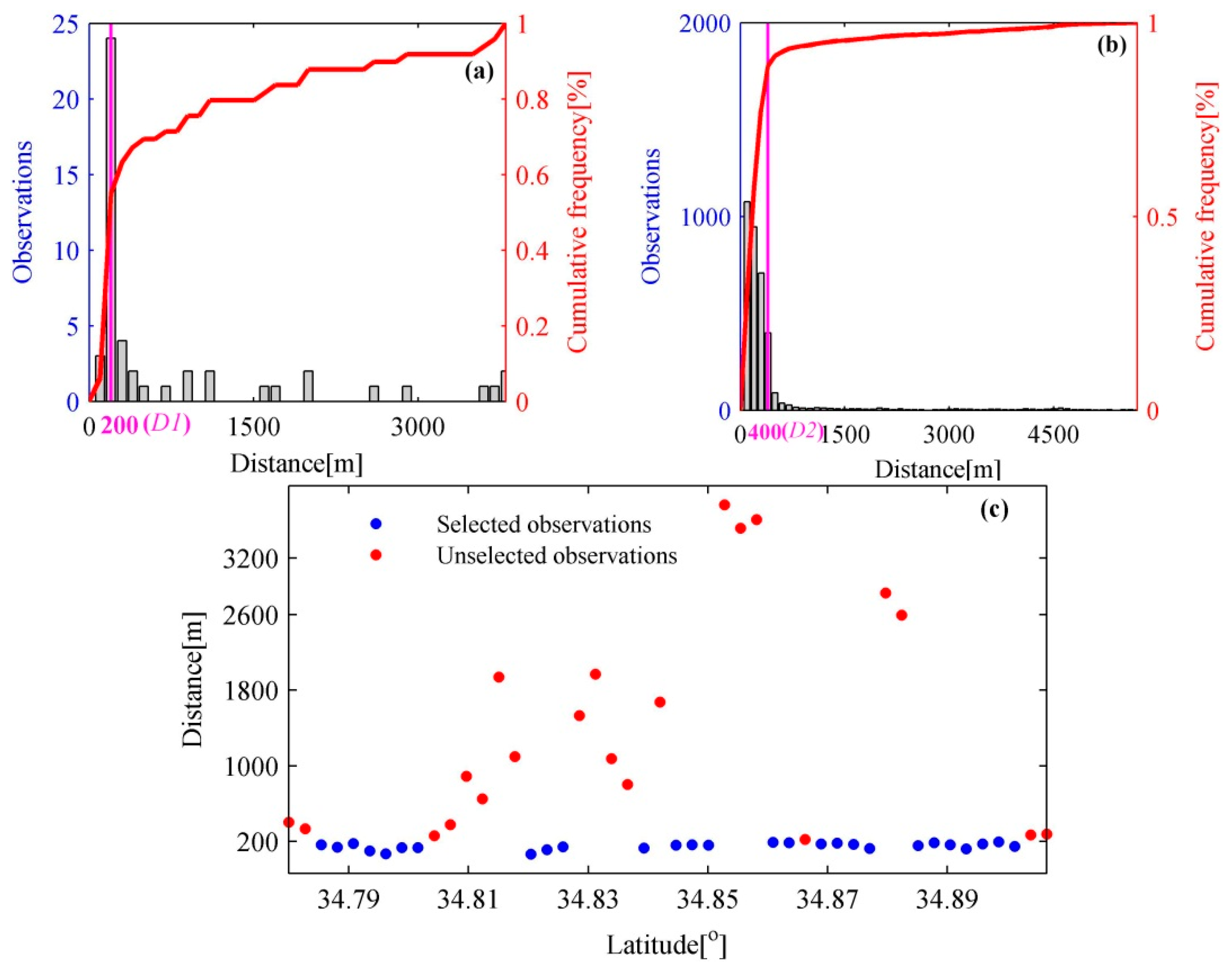
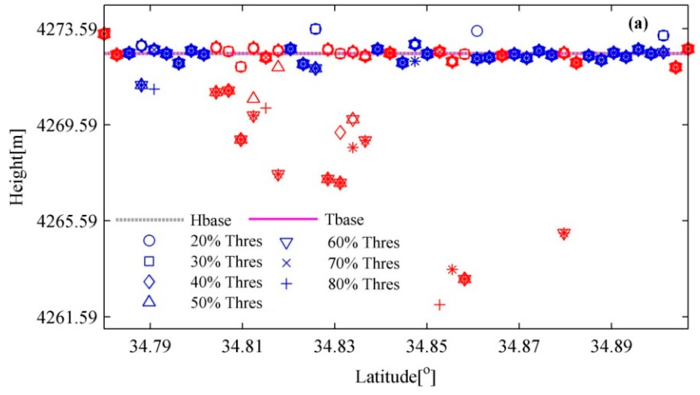
3.3. Determination of Reference Water Level Hbase
- (1)
- Calculate the distance between the nadir and corresponding Level-2 position for each observation in the present track, and construct the cumulative distribution function (CDF) of these distances at 100 m intervals. After this, we can obtain the distance corresponding to the minimum second-order difference quotient of this CDF, which is considered as D1.
- (2)
- Repeat step 1 for all observations of all tracks over the lake and obtain another distance as D2.
- (3)
- The minimum of D1 and D2 is finally accepted as D for the present track. The reason for this is that the present track may be dominated by the off-nadir observations, thus it is difficult to get a reasonable D if only this track is processed. Therefore, all observations of all tracks over the lake are considered.
4. Results and Discussion
4.1. Comparison of Retracking Methods
4.1.1. Multi-Peak Waveform Processing
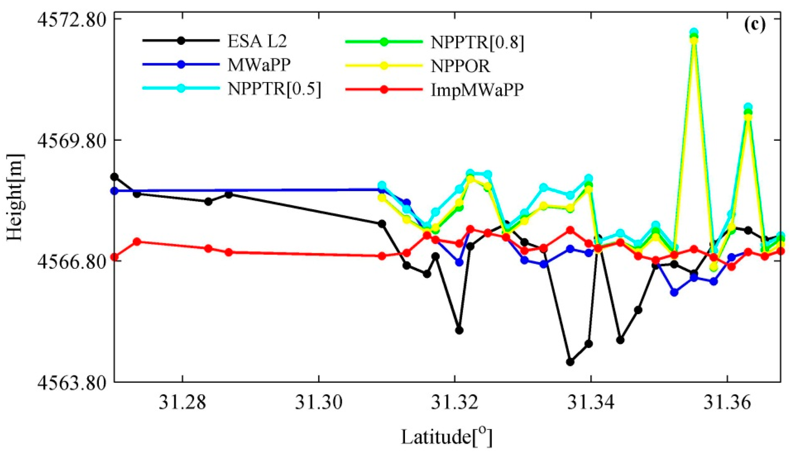
4.1.2. Comparison of Along-Track Water Levels
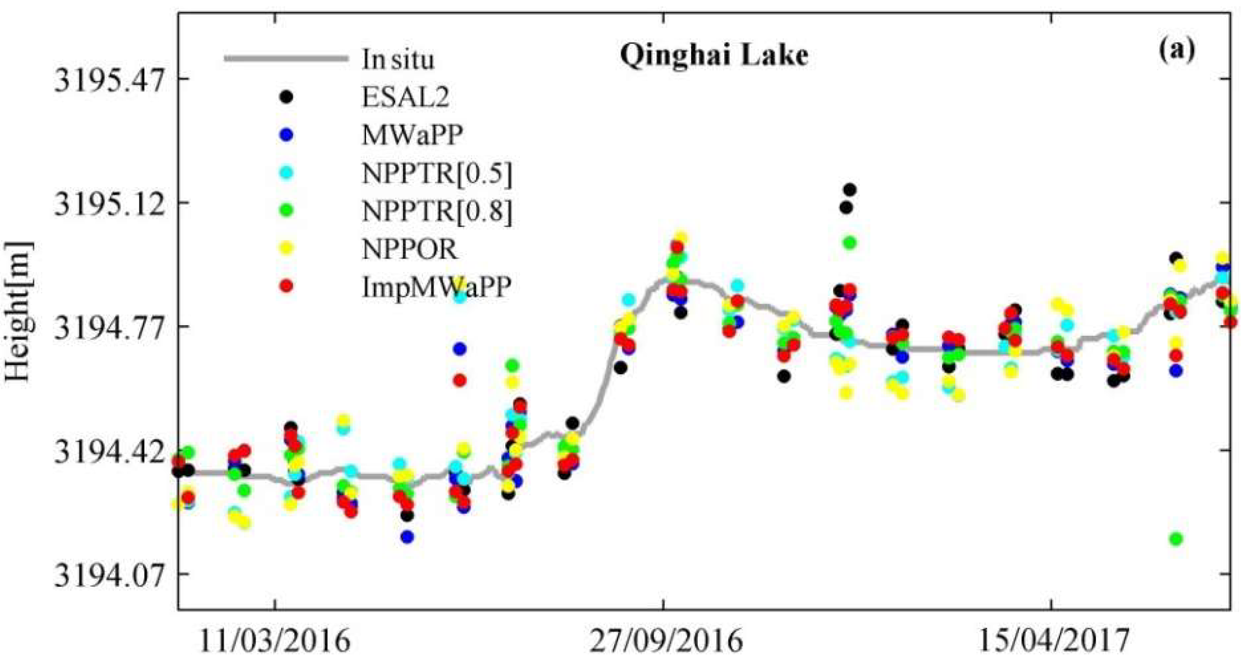
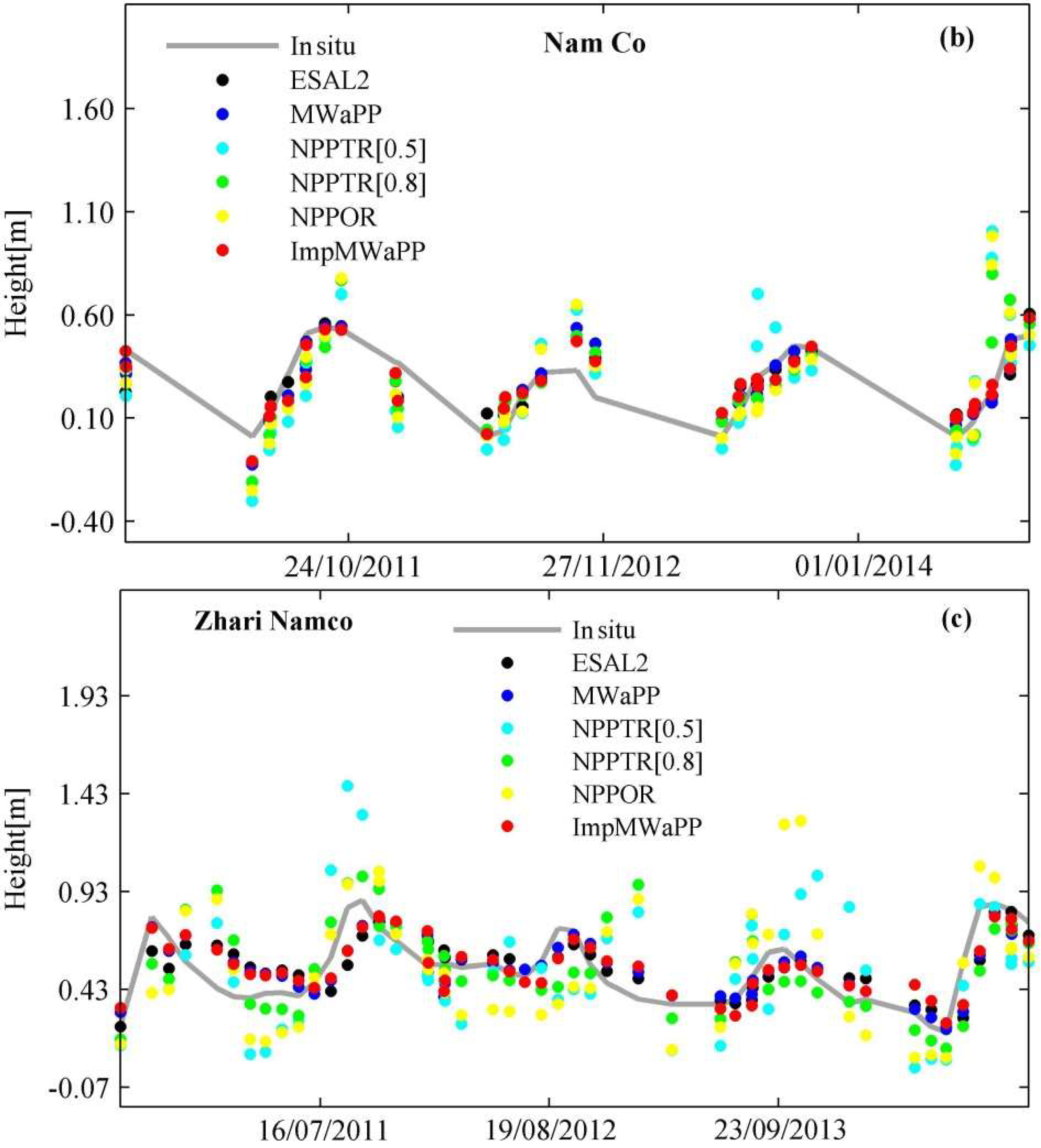
4.2. Time Series
4.3. Time Series of Icing and No-Ice Periods
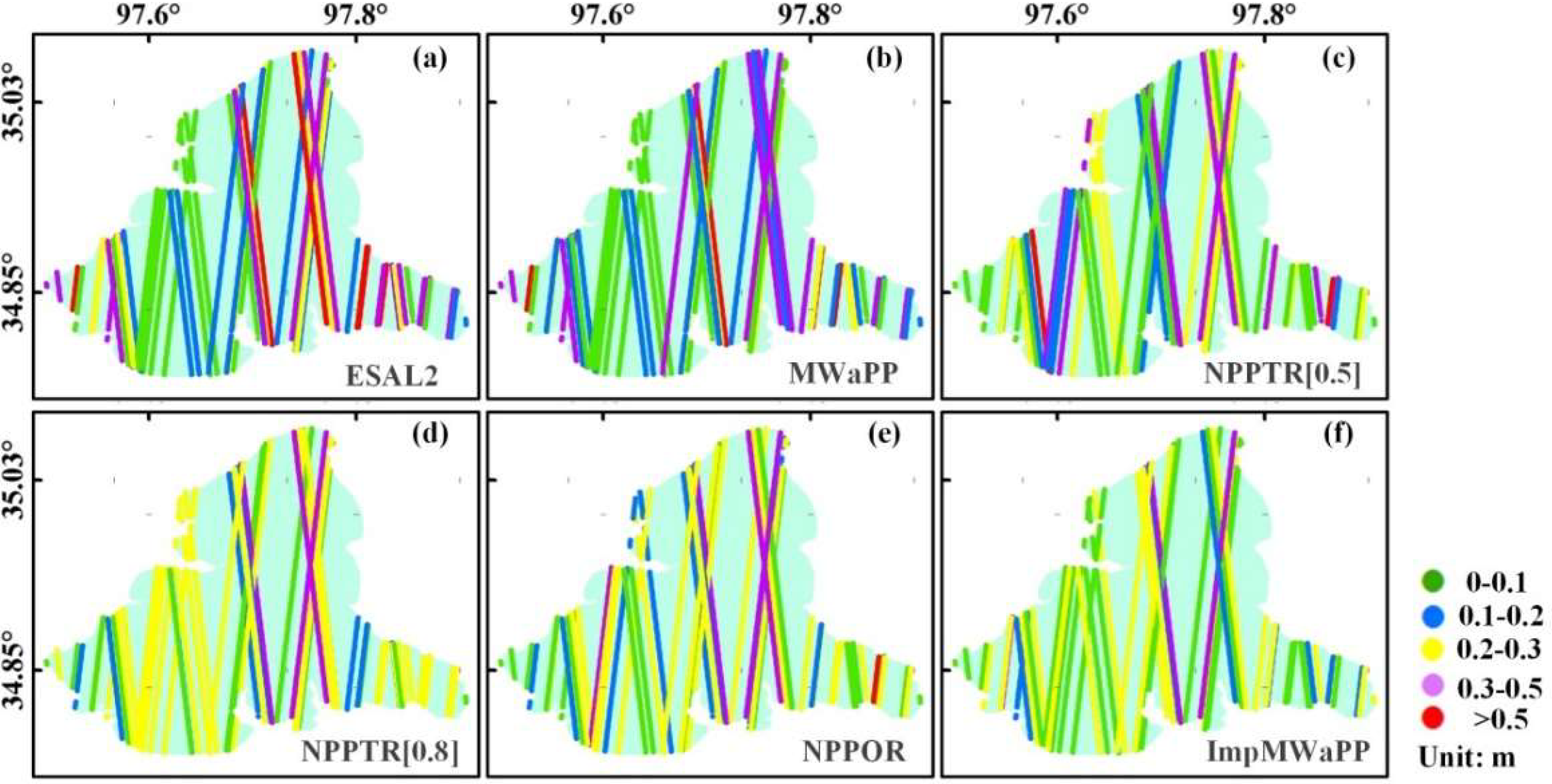
4.4. Along-Track Standard Deviations
5. Conclusions
Author Contributions
Funding
Acknowledgments
Conflicts of Interest
Appendix A


| Lake Name | ESAL2 | MWaPP | NPPTR[0.5] | NPPTR[0.8] | NPPOR | ImpMWaPP |
|---|---|---|---|---|---|---|
| Qinghai Lake | 3196.316 m | - | 3197.114 m | 3196.246 m | 3194.727 m | - |
| 3196.446 m | ||||||
| 3196.617 m | ||||||
| Nam Co | 5069.691 m | 5087.456 m | 5087.989 m | 5087.395 m | 5087.663 m | - |
| Zhari Namco | 4949.409 m | - | 4617.650 m | 4982.618 m | 4617.647 m | - |
| 4982.154 m | 4980.273 m | |||||
| Ngoring Lake | - | - | - | - | - | - |
| Longyangxia | - | - | - | - | - | - |
| Bamco | 4646.898 m | 4706.849 m | 4569.472 m | - | - | - |
| Dawa Co | 4626.380 m | - | 4629.480 m | - | - | - |
| Lake Name | ESAL2 | MWaPP | NPPTR[0.5] | NPPTR[0.8] | NPPOR | ImpMWaPP |
|---|---|---|---|---|---|---|
| Qinghai Lake | 3195.919 m | 3195.552 m | 3195.903 m | 3195.695 m | 3195.657 m | 3195.539 m |
| [0.24 m] | [0.22 m] | [0.22 m] | [0.22 m] | [0.23 m] | [0.22 m] | |
| NamCo | 4726.067 m | 4725.733 m | 4726.235 m | 4725.955 m | 4725.968 m | 4725.715 m |
| [0.30 m] | [0.33 m] | [0.46 m] | [0.36 m] | [0.43 m] | [0.32 m] | |
| Zhari Namco | 4615.237 m | 4614.912 m | 4615.467 m | 4615.149 m | 4615.185 m | 4614.892 m |
| [0.17 m] | [0.18 m] | [0.49 m] | [0.35 m] | [0.49 m] | [0.17 m] | |
| Ngoring Lake | 4272.831 m | 4272.532 m | 4273.130 m | 4272.834 m | 4272.625 m | 4272.837 m |
| [0.53 m] | [0.51 m] | [0.42 m] | [0.36 m] | [0.38 m] | [0.32 m] | |
| Longyangxia | 2576.587 m | 2573.791 m | 2574.390 m | 2574.180 m | 2574.122 m | 2573.583 m |
| [1.76 m] | [4.12 m] | [4.43 m] | [4.38 m] | [4.44 m] | [3.99 m] | |
| Bamco | 4567.314 m | 4567.085 m | 4567.479 m | 4567.296 m | 4567.190 m | 4567.094 m |
| [0.36 m] | [0.11 m] | [0.24 m] | [0.17 m] | [0.21 m] | [0.15 m] | |
| Dawa Co | 4627.790 | 4627.543 m | 4627.723 m | 4627.640 m | 4627.582 m | 4627.429 m |
| [0.21 m] | [0.41 m] | [0.22 m] | [0.290 m] | [0.31 m] | [0.28 m] |
References
- Birkett, C.M. The contribution of TOPEX/POSEIDON to the global monitoring of climatically sensitive lakes. J. Geophys. Res. 1995, 100, 25179–25204. [Google Scholar] [CrossRef]
- Birkett, C.M. Contribution of the Topex NASA radar altimeter to the global monitoring of large rivers and wetlands. Water Resour. Res. 2004, 34, 1223–1239. [Google Scholar] [CrossRef]
- Berry, P.A.M. Two Decades of Inland Water Monitoring Using Satellite Radar Altimetry. In Proceedings of the Symposium on 15 Years of Progress in Radar Altimetry, Venice, Italy, 13–18 March 2006. [Google Scholar]
- Santos da Silva, J.; Seyler, F.; Calmant, S.; Rotunno Filho, O.C.; Roux, E.; Araújo, A.A.M.; Guyot, J.L. Water level dynamics of Amazon wetlands at the watershed scale by satellite altimetry. Int. J. Remote Sens. 2012, 33, 3323–3353. [Google Scholar] [CrossRef]
- Duan, Z.; Bastiaanssen, W.G.M. Estimating water volume variations in lakes and reservoirs from four operational satellite altimetry databases and satellite imagery data. Remote Sens. Environ. 2013, 134, 403–416. [Google Scholar] [CrossRef]
- Tong, X.; Pang, H.; Xie, H.; Xu, X.; Li, F.; Chen, L.; Luo, X.; Liu, S.; Chen, P.; Jin, Y. Estimating water volume variations in Lake Victoria over the past 22 years using multi-mission altimetry and remotely sensed images. Remote Sens. Environ. 2016, 187, 400–413. [Google Scholar] [CrossRef]
- Crétaux, J.-F.; Abarca-del-Río, R.; Bergé-Nguyen, M.; Arsen, A.; Drolon, V.; Clos, G.; Maisongrande, P. Lake volume monitoring from space. Surv. Geophys. 2016, 37, 269–305. [Google Scholar] [CrossRef]
- Cretaux, J.F.; Birkett, C. Lake studies from satellite radar altimetry. C. R. Geosci. 2006, 338, 1098–1112. [Google Scholar] [CrossRef]
- Ričko, M.; Birkett, C.M.; Carton, J.A.; Crétaux, J.-F. Intercomparison and validation of continental water level products derived from satellite radar altimetry. J. Appl. Remote Sens. 2012, 6, 061710. [Google Scholar] [CrossRef] [Green Version]
- Kleinherenbrink, M.; Ditmar, P.; Lindenbergh, R. Retracking cryosat data in the sarin mode and robust lake level extraction. Remote Sens. Environ. 2014, 152, 38–50. [Google Scholar] [CrossRef]
- Baup, F.; Frappart, F.; Maubant, J. Combining high-resolution satellite images and altimetry to estimate the volume of small lakes. Hydrol. Earth Syst. Sci. 2014, 18, 2007–2020. [Google Scholar] [CrossRef] [Green Version]
- Kleinherenbrink, M.; Lindenbergh, R.C.; Ditmar, P.G. Monitoring of lake level changes on the Tibetan Plateau and Tian Shan by retracking Cryosat SARIn waveforms. J. Hydrol. 2015, 521, 119–131. [Google Scholar] [CrossRef]
- Bouzinac, C. CryoSat Product Handbook. Available online: https://earth.esa.int/documents/10174/125272/CryoSat_Product_Handbook (accessed on 1 January 2018).
- Jiang, L.; Nielsen, K.; Andersen, O.B.; Bauer-Gottwein, P. Monitoring recent lake level variations on the Tibetan Plateau using CryoSat-2 SARIn mode data. J. Hydrol. 2017, 544, 109–124. [Google Scholar] [CrossRef]
- Nielsen, K.; Stenseng, L.; Andersen, O.; Knudsen, P. The Performance and Potentials of the CryoSat-2 SAR and SARIn Modes for Lake Level Estimation. Water 2017, 9, 374. [Google Scholar] [CrossRef]
- Raney, R.K. The Delay/Doppler Radar Altimeter. IEEE Trans. Geosci. Remote Sens. 1998, 36, 1578–1588. [Google Scholar] [CrossRef]
- Villadsen, H.; Deng, X.; Andersen, O.B.; Stenseng, L.; Nielsen, K.; Knudsen, P. Improved inland water levels from SAR altimetry using novel empirical and physical retrackers. J. Hydrol. 2016, 537, 234–247. [Google Scholar] [CrossRef] [Green Version]
- Nielsen, K.; Stenseng, L.; Andersen, O.B.; Villadsen, H.; Knudsen, P. Validation of CryoSat-2 SAR mode based lake levels. Remote Sens. Environ. 2015, 171, 162–170. [Google Scholar] [CrossRef] [Green Version]
- Göttl, F.; Dettmering, D.; Müller, F.; Schwatke, C. Lake Level Estimation Based on CryoSat-2 SAR Altimetry and Multi-Looked Waveform Classification. Remote Sens. 2016, 8, 885. [Google Scholar] [CrossRef]
- Gommenginger, C.; Thibaut, P.; Fenoglio-Marc, L.; Quartly, G.; Deng, X.; Gómez-Enri, J.; Challenor, P.; Gao, Y. Retracking altimeter waveforms near the coasts. In Coastal Altimetry; Benveniste, J., Cipollini, P., Kostianoy, A.G., Vignudelli, S., Eds.; Springer: Berlin, Germany, 2011; pp. 61–101. [Google Scholar]
- Ganguly, D.; Chander, S.; Desai, S.; Chauhan, P. A subwaveform-based retracker for multipeak waveforms: A case study over Ukai dam/reservoir. Mar. Geod. 2015, 38, 581–596. [Google Scholar] [CrossRef]
- Wan, W.; Long, D.; Hong, Y.; Ma, Y.; Yuan, Y.; Xiao, P.; Duan, H.; Han, Z.; Gu, X. A lake data set for the Tibetan Plateau from the 1960s, 2005, and 2014. Sci. Data 2016, 3, 160039. [Google Scholar] [CrossRef] [PubMed]
- Scagliola, M.; Fornari, M. Main Evolutions and Expected Quality Improvements in BaselineC Level1b Products. Available online: https://wiki.services.eoportal.org/tiki-download_wiki_attachment.php?attId=3553&page=CryoSat%20Technical%20Notes&download=y (accessed on 1 January 2018).
- Pavlis, N.K.; Holmes, S.A.; Kenyon, S.C.; Factor, J.K. The development and evaluation of the Earth Gravitational Model 2008 (EGM2008). J. Geophys. Res. Solid Earth 2012. [Google Scholar] [CrossRef]
- Zhao, Y.; Liao, J.; Shen, G.; Zhang, X. Monitoring the water level changes in Qinghai Lake with satellite altimetry data. J. Remote Sens. 2017, 21, 633–644. (In Chinese) [Google Scholar]
- Hwang, C.; Peng, M.F.; Ning, J.; Luo, J.; Sui, C.H. Lake level variations in China from TOPEX/poseidon altimetry: Data quality assessment and links to precipitation and ENSO. Geophys. J. Int. 2005, 161, 1–11. [Google Scholar] [CrossRef]
- Wingham, D.; Rapley, C.; Griffiths, H. New Techniques in Satellite Altimeter Tracking Systems. In Proceedings of the 1986 International Geoscience and Remote Sensing Symposium (IGARSS’86) on Remote Sensing: Today’s Solutions for Tomorrow’s Information Needs, Zürich, Switzerland, 8–11 September 1986. [Google Scholar]
- Jain, M.; Andersen, O.B.; Dall, J.; Stenseng, L. Sea surface height determination in the Arctic using Cryosat-2 SAR data from primary peak empirical retrackers. Adv. Space Res. 2015, 55, 40–50. [Google Scholar] [CrossRef]
- Wingham, D.; Francis, C.; Baker, S.; Bouzinac, C.; Brockley, D.; Cullen, R.; de Chateau-Thierry, P.; Laxon, S.W.; Mallow, U.; Mavrocordatos, C.; et al. CryoSat: A mission to determine the fluctuations in Earth’s land and marine ice fields. Adv. Space Res. 2006, 37, 841–871. [Google Scholar] [CrossRef]
- Song, C.; Ye, Q.; Cheng, X. Shifts in water-level variation of Namco in the central Tibetan Plateau from ICESat and CryoSat-2 altimetry and station observations. Sci. Bull. 2015, 60, 1287–1297. [Google Scholar] [CrossRef]
- Sørensen, L.S.; Simonsen, S.B.; Nielsen, K.; Lucas-Picher, P.; Spada, G.; Adalgeirsdottir, G.; Forsberg, R.; Hvidberg, C.S. Mass balance of the Greenland ice sheet (2003–2008) from ICESat data—The impact of interpolation, sampling and firn density. Cryosphere 2011, 5, 173–186. [Google Scholar] [CrossRef] [Green Version]
- MSADC. Available online: http://www.msadc.cn/en/sy (accessed on 5 September 2018).
- Biancamaria, S.; Lettenmaier, D.P.; Pavelsky, T.M. The SWOT Mission and Its Capabilities for Land Hydrology. Surv. Geophys. 2016, 37, 307–337. [Google Scholar] [CrossRef]


| Lake Name | Coordinates | Area [km2] | Altitude 1 [m] | Tracks 2 | Date | Mode |
|---|---|---|---|---|---|---|
| Qinghai Lake | 100.20, 36.89 | 4435 | 3194 | 49 | 01/2016–08/2017 | Absolute |
| Nam Co | 90.60, 30.74 | 1920 | 4724 | 79 | 11/2010–12/2014 | Relative |
| Zhari Namco | 85.61, 30.93 | 1023 | 4612 | 59 | 04/2010–12/2014 | Relative |
| Ngoring Lake | 97.70, 34.90 | 610 | 4267 | 58 | 09/2010–12/2015 | Absolute |
| Longyangxia | 100.73, 36.01 | 359 | 2569 | 5 | 12/2015–06/2017 | Absolute |
| Bamco | 90.58, 31.27 | 180 | 4560 | 8 | 06/2013–12/2014 | Relative |
| Dawa Co | 84.96, 31.24 | 118 | 4623 | 6 | 06/2013–12/2014 | Relative |
| Lake Name | ESAL2 | MWaPP | NPPTR[0.5] | NPPTR[0.8] | NPPOR | ImpMWaPP |
|---|---|---|---|---|---|---|
| Qinghai Lake | 0.113 m | 0.092 m | 0.096 m | 0.121 m | 0.114 m | 0.085 m |
| [48,48] | [49,49] | [48,48] | [48,48] | [46,46] | [49,49] | |
| Nam Co | 0.094 m | 0.094 m | 0.240 m | 0.159 m | 0.213 m | 0.093 m |
| [78,36] | [78,36] | [78,36] | [78,36] | [78,36] | [79,36] | |
| Zhari Namco | 0.120 m | 0.106 m | 0.254 m | 0.192 m | 0.257 m | 0.109 m |
| [58,50] | [59,51] | [57,49] | [58,50] | [57,49] | [59,51] | |
| Ngoring Lake | 0.314 m | 0.289 m | 0.241 m | 0.164 m | 0.189 m | 0.159 m |
| [58,58] | [58,58] | [58,58] | [58,58] | [58,58] | [58,58] | |
| Longyangxia | 3.701 m | 0.871 m | 0.930 m | 0.951 m | 0.921 m | 0.573 m |
| [5,5] | [5,5] | [5,5] | [5,5] | [5,5] | [5,5] | |
| Bamco | 0.397 m | 0.079 m | 0.251 m | 0.156 m | 0.210 m | 0.087 m |
| [7,5] | [7,5] | [7,6] | [8,6] | [8,6] | [8,6] | |
| Dawa Co | 0.112 m | 0.146 m | 0.128 m | 0.105 m | 0.143 m | 0.122 m |
| [5,5] | [6,5] | [5,4] | [6,5] | [6,5] | [6,5] |
| Lake Name | ESAL2 | MWaPP | NPPTR[0.5] | NPPTR[0.8] | NPPOR | ImpMWaPP |
|---|---|---|---|---|---|---|
| Qinghai Lake | 0.138 m | 0.073 m | 0.078 m | 0.075 m | 0.094 m | 0.079 m |
| [23] | [23] | [23] | [23] | [22] | [23] | |
| Nam Co | 0.133 m | 0.136 m | 0.276 m | 0.170 m | 0.217 m | 0.131 m |
| [2] | [2] | [2] | [2] | [2] | [2] | |
| Zhari Namco | 0.126 m | 0.120 m | 0.264 m | 0.228 m | 0.239 m | 0.111 m |
| [14] | [14] | [14] | [14] | [14] | [14] | |
| Ngoring Lake | 0.402 m | 0.370 m | 0.182 m | 0.168 m | 0.168 m | 0.156 m |
| [23] | [23] | [23] | [23] | [23] | [23] |
| Lake Name | ESAL2 | MWaPP | NPPTR[0.5] | NPPTR[0.8] | NPPOR | ImpMWaPP |
|---|---|---|---|---|---|---|
| Qinghai Lake | 0.083 m | 0.107 m | 0.111 m | 0.152 m | 0.130 m | 0.089 m |
| [25] | [26] | [25] | [25] | [24] | [26] | |
| Nam Co | 0.091 m | 0.091 m | 0.237 m | 0.159 m | 0.213 m | 0.091 m |
| [34] | [34] | [34] | [34] | [34] | [34] | |
| Zhari Namco | 0.118 m | 0.096 m | 0.251 m | 0.175 m | 0.263 m | 0.104 m |
| [36] | [37] | [35] | [36] | [35] | [37] | |
| Ngoring Lake | 0.239 m | 0.219 m | 0.273 m | 0.161 m | 0.201 m | 0.161 m |
| [35] | [35] | [35] | [35] | [35] | [35] |
| Lake Name | ESAL2 | MWaPP | NPPTR[0.5] | NPPTR[0.8] | NPPOR | ImpMWaPP |
|---|---|---|---|---|---|---|
| Qinghai Lake | 0.170 m | 0.145 m | 0.413 m | 0.394 m | 0.396 m | 0.098 m |
| [0.116 m] | [0.092 m] | [0.401 m] | [0.366 m] | [0.379 m] | [0.084 m] | |
| Nam Co | 0.251 m | 0.246 m | 0.490 m | 0.479 m | 0.472 m | 0.208 m |
| [0.137 m] | [0.156 m] | [0.457 m] | [0.422 m] | [0.446 m] | [0.102 m] | |
| Zhari Namco | 0.213 m | 0.241 m | 0.674 m | 0.636 m | 0.618 m | 0.108 m |
| [0.158 m] | [0.157 m] | [0.502 m] | [0.463 m] | [0.475 m] | [0.105 m] | |
| Ngoring Lake | 0.256 m | 0.239 m | 0.267 m | 0.254 m | 0.254 m | 0.129 m |
| [0.122 m] | [0.105 m] | [0.216 m] | [0.229 m] | [0.217 m] | [0.097 m] | |
| Longyangxia | 0.668 m | 0.295 m | 0.532 m | 0.464 m | 0.519 m | 0.126 m |
| [0.442 m] | [0.098 m] | [0.622 m] | [0.350 m] | [0.608 m] | [0.089 m] | |
| Bamco | 0.389 m | 0.461 m | 0.626 m | 0.594 m | 0.581 m | 0.178 m |
| [0.190 m] | [0.182 m] | [0.697 m] | [0.651 m] | [0.662 m] | [0.127 m] | |
| Dawa Co | 0.320 m | 0.224 m | 0.478 m | 0.461 m | 0.523 m | 0.128 m |
| [0.239 m] | [0.163 m] | [0.480 m] | [0.487 m] | [0.492 m] | [0.110 m] |
© 2018 by the authors. Licensee MDPI, Basel, Switzerland. This article is an open access article distributed under the terms and conditions of the Creative Commons Attribution (CC BY) license (http://creativecommons.org/licenses/by/4.0/).
Share and Cite
Xue, H.; Liao, J.; Zhao, L. A Modified Empirical Retracker for Lake Level Estimation Using Cryosat-2 SARin Data. Water 2018, 10, 1584. https://doi.org/10.3390/w10111584
Xue H, Liao J, Zhao L. A Modified Empirical Retracker for Lake Level Estimation Using Cryosat-2 SARin Data. Water. 2018; 10(11):1584. https://doi.org/10.3390/w10111584
Chicago/Turabian StyleXue, Hui, Jingjuan Liao, and Lifei Zhao. 2018. "A Modified Empirical Retracker for Lake Level Estimation Using Cryosat-2 SARin Data" Water 10, no. 11: 1584. https://doi.org/10.3390/w10111584
APA StyleXue, H., Liao, J., & Zhao, L. (2018). A Modified Empirical Retracker for Lake Level Estimation Using Cryosat-2 SARin Data. Water, 10(11), 1584. https://doi.org/10.3390/w10111584