
Satellite-Based Run-Off Model for Monitoring Drought in Peninsular Malaysia

 , ,
, ,
Abstract
:
1. Introduction
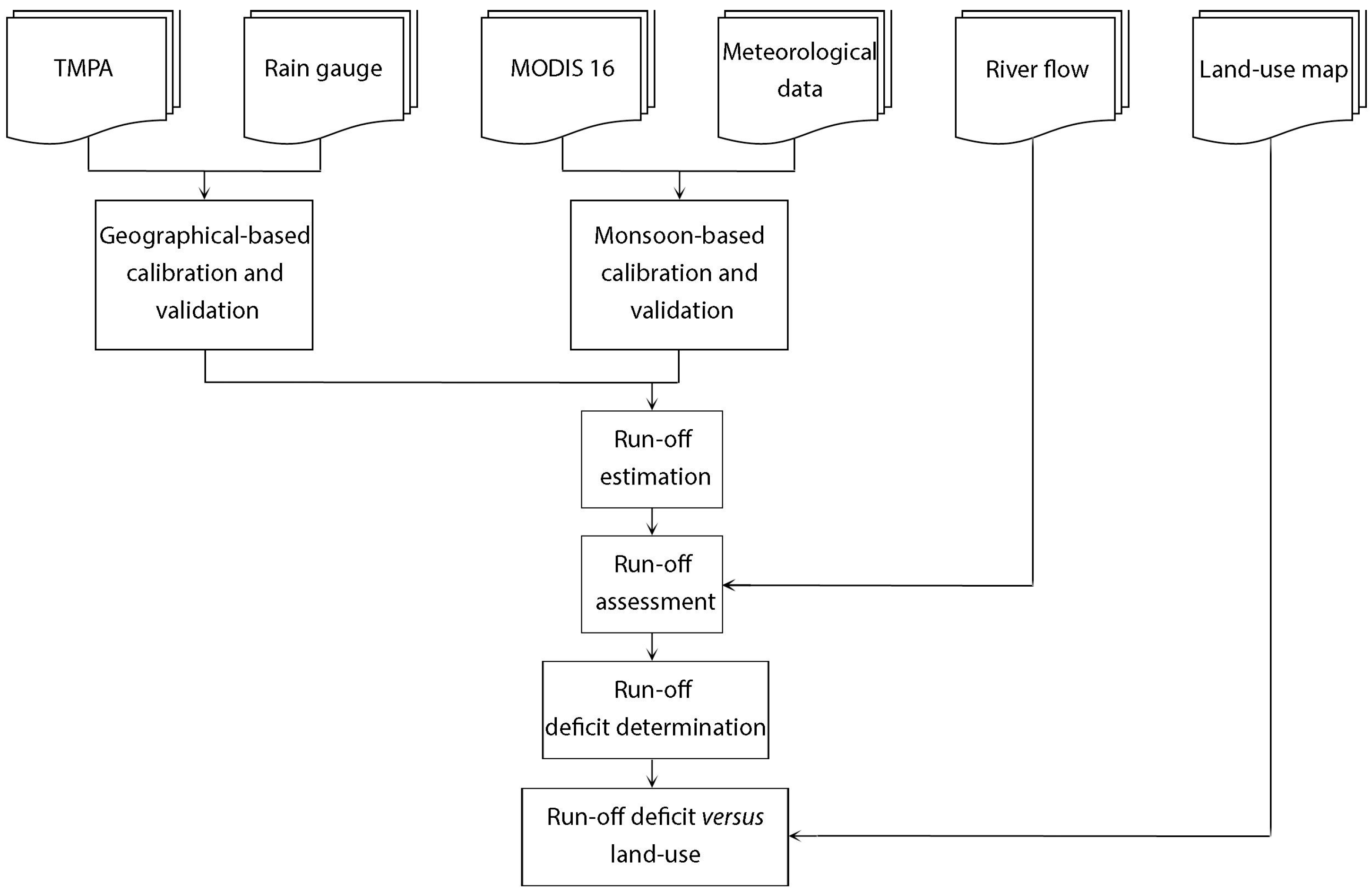
2. Materials and Methods
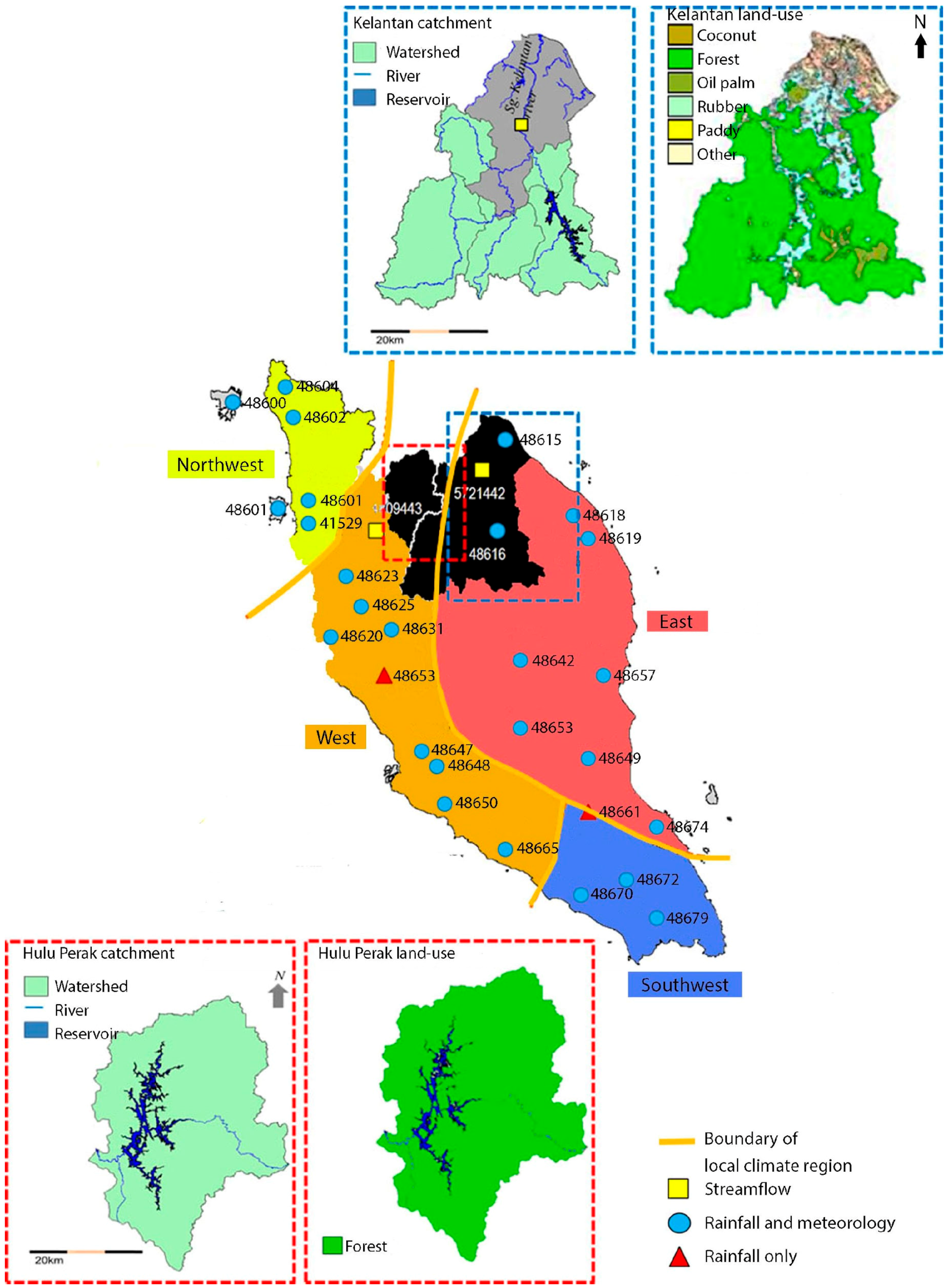
2.1. Study Site
2.2. Datasets and Methods
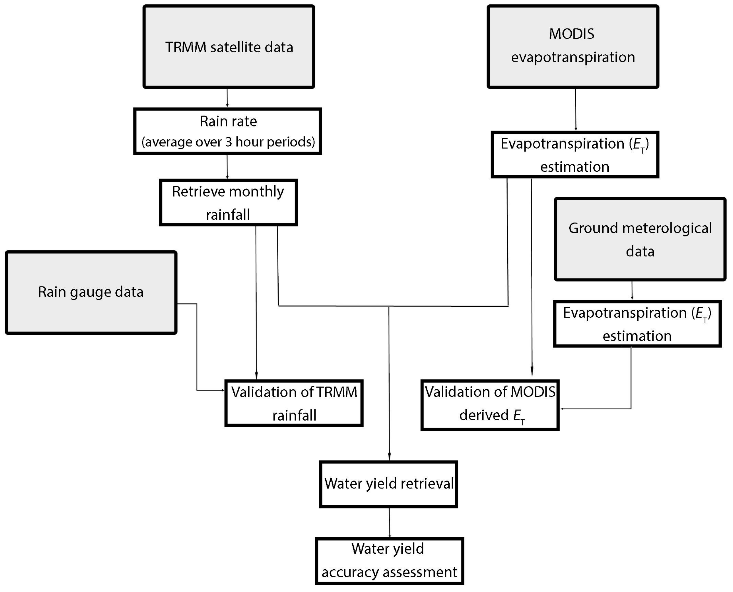
2.2.1. Rainfall Retrieval from TRMM Multi Satellites Precipitation Analysis Data (TMPA)
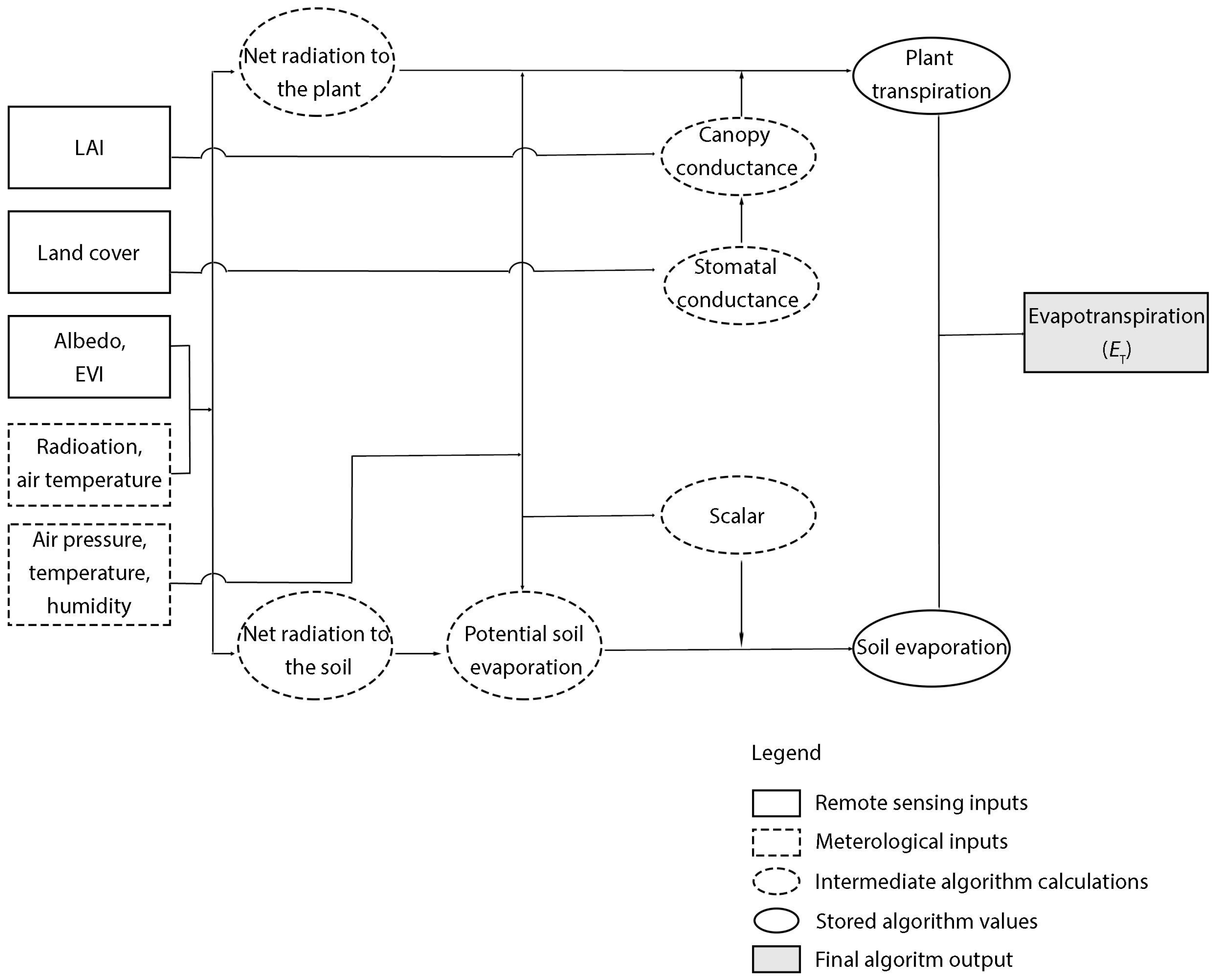
2.2.2. Calibration for Evapotranspiration (ET) retrieval from MODIS16A Data Set
2.2.3. Accuracy Assessment
3. Results
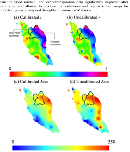
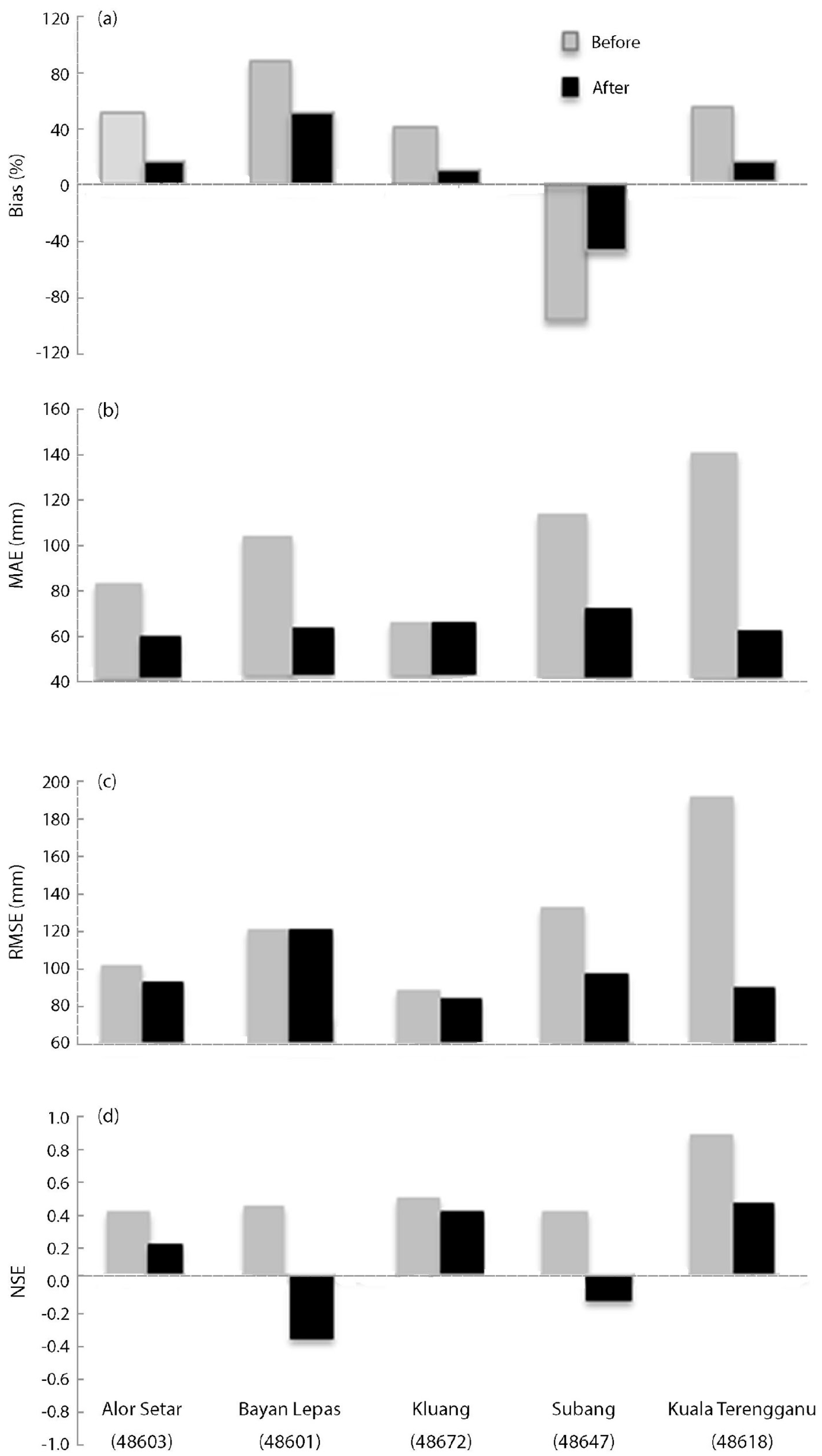
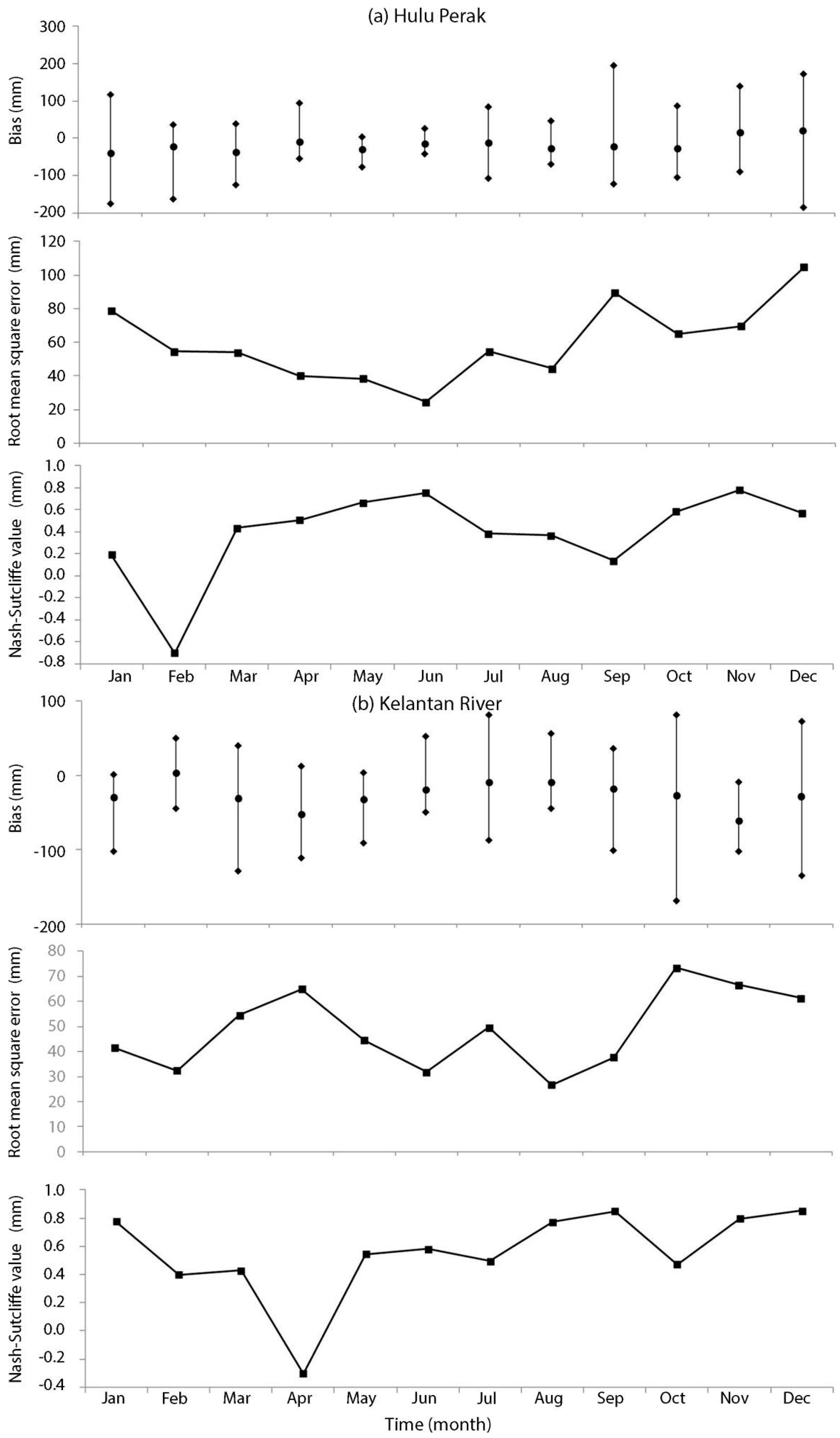
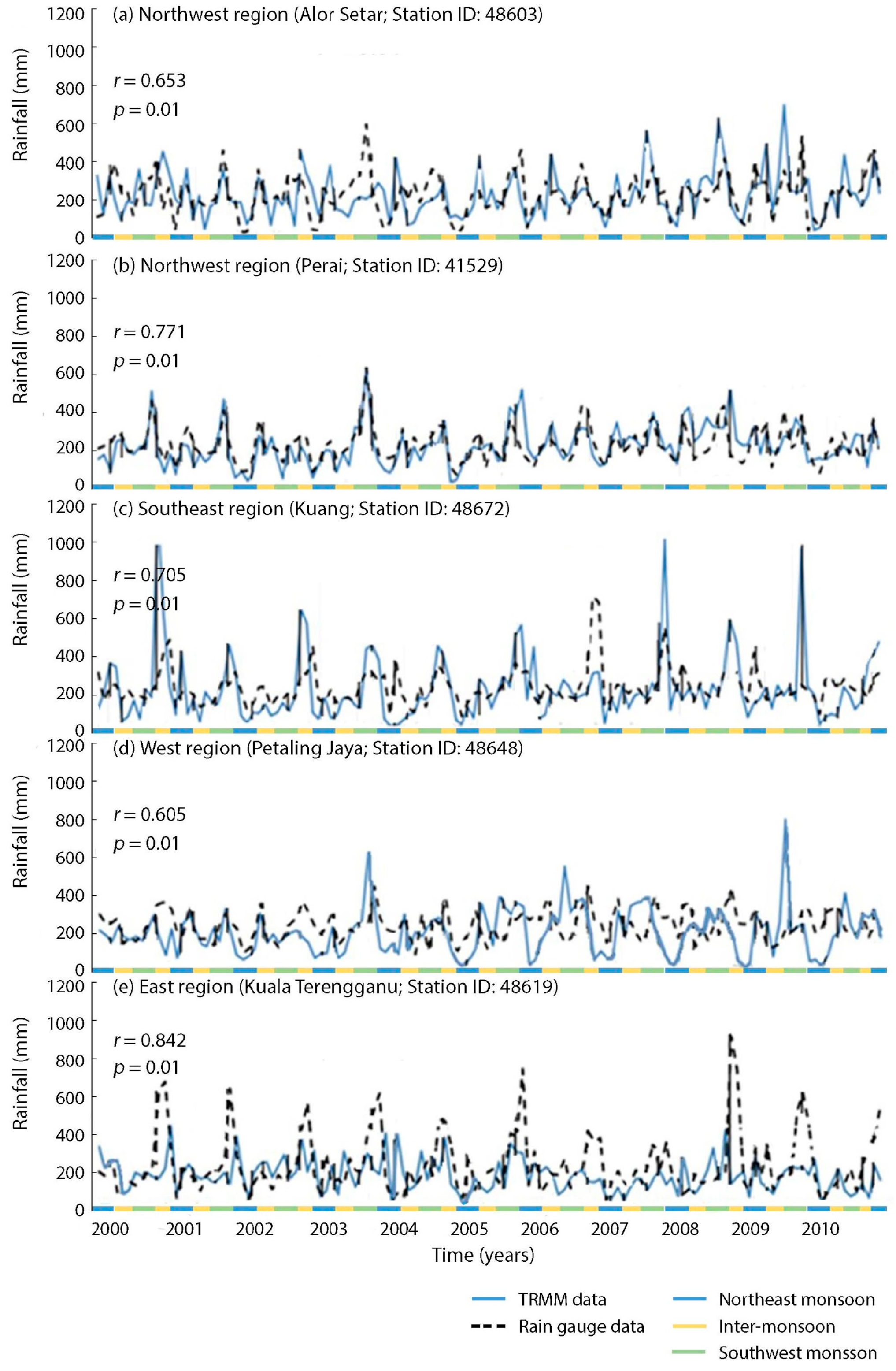
3.1. Validation of TMPA Rainfall Calibrated with Un-Calibrated Data
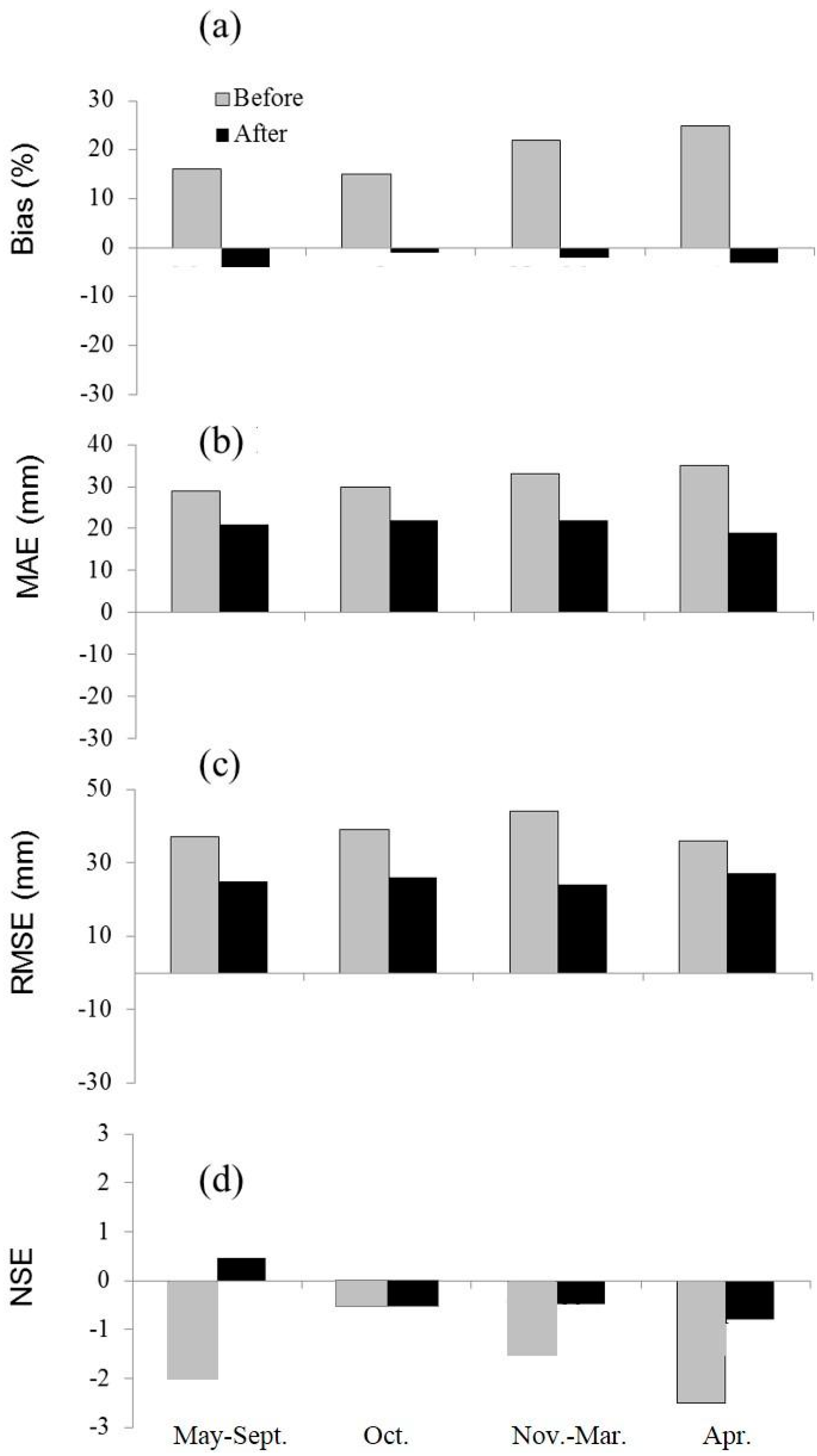
3.2. Assessment of MODIS 16 Calibrated Data
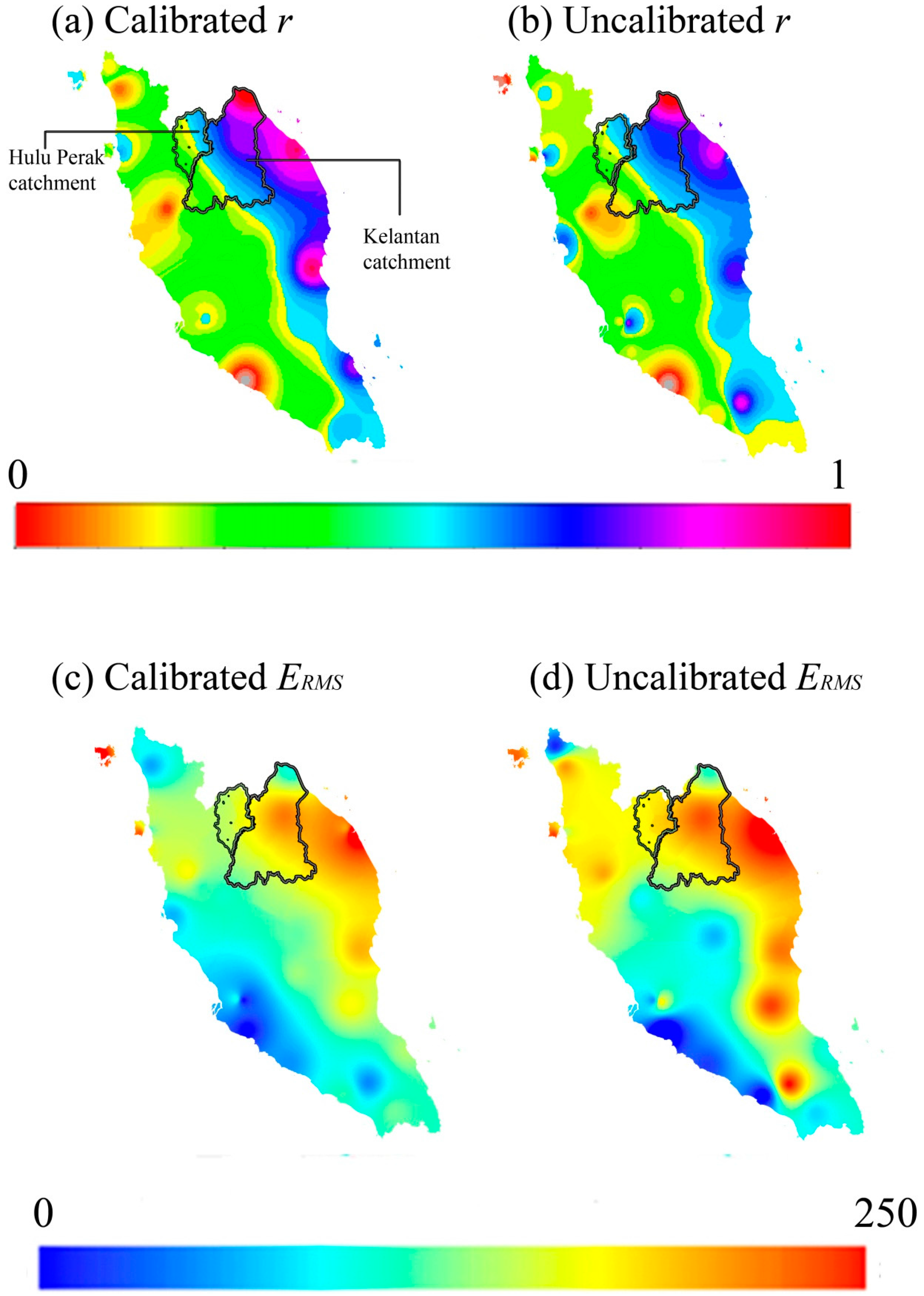
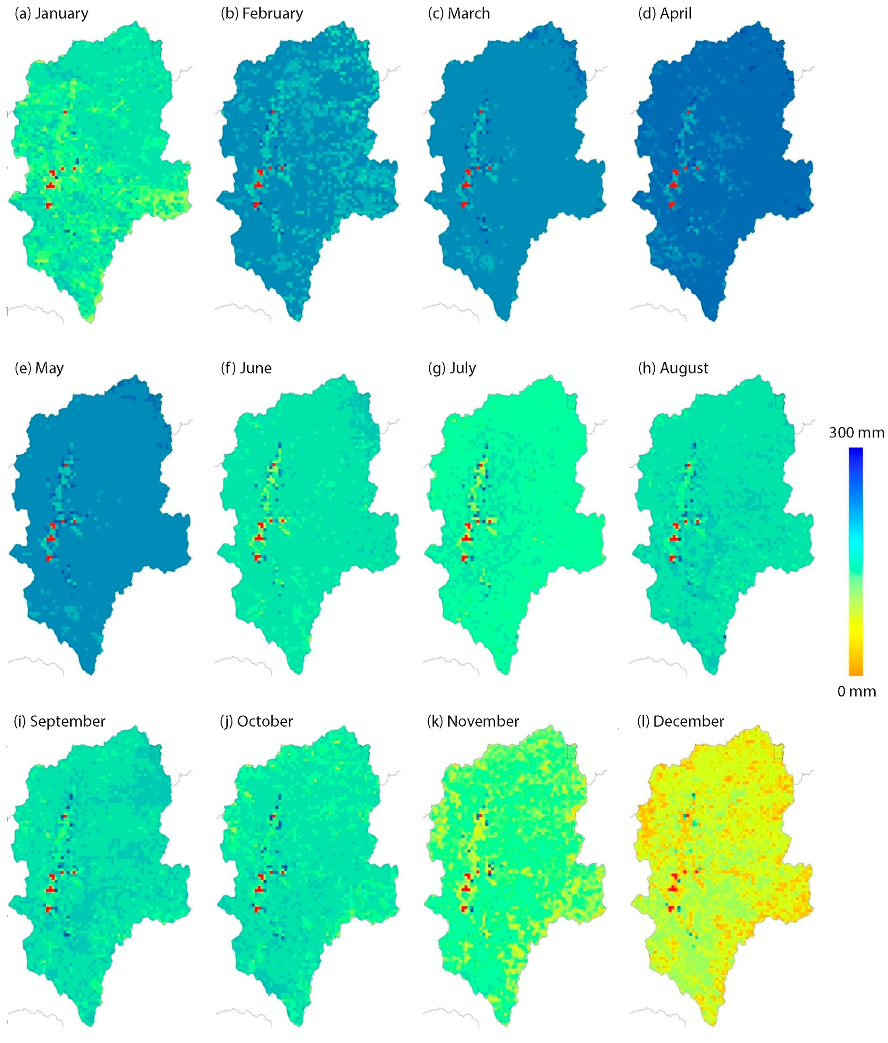
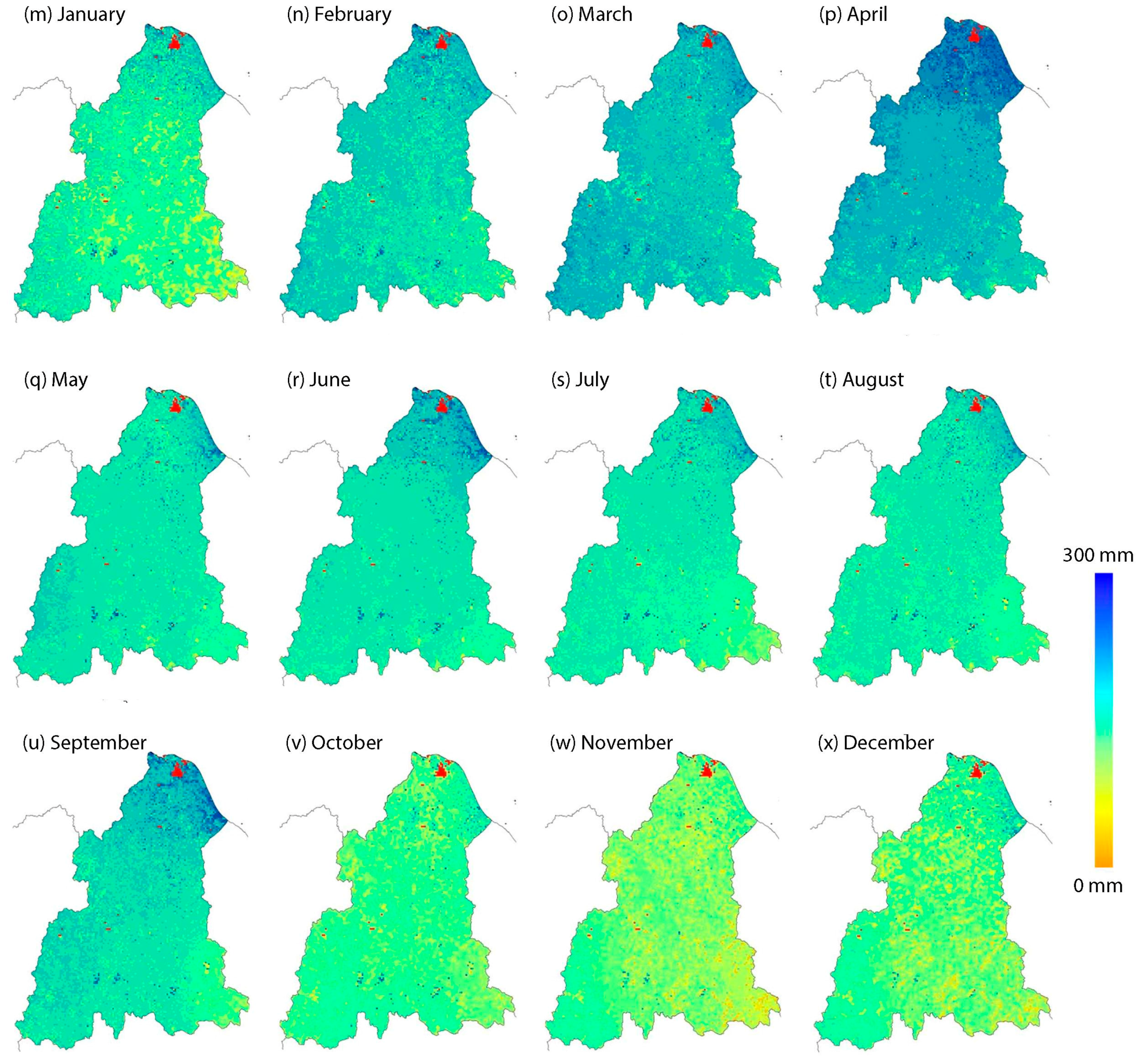
3.3. Assessment of Spatial-Based Run-off Deficit
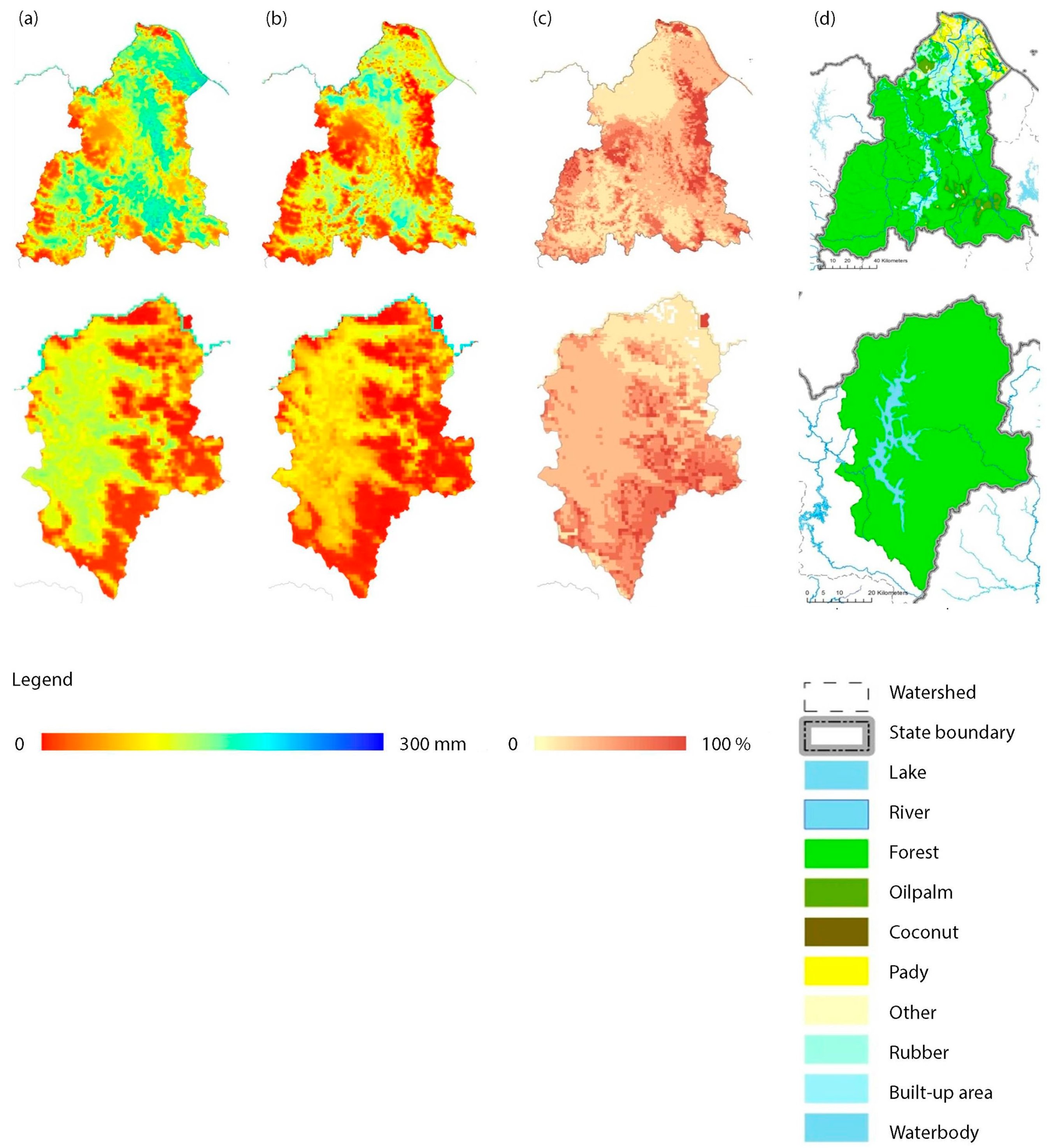
3.3.1. Land-Use Versus Run-off Deficiency Analysis
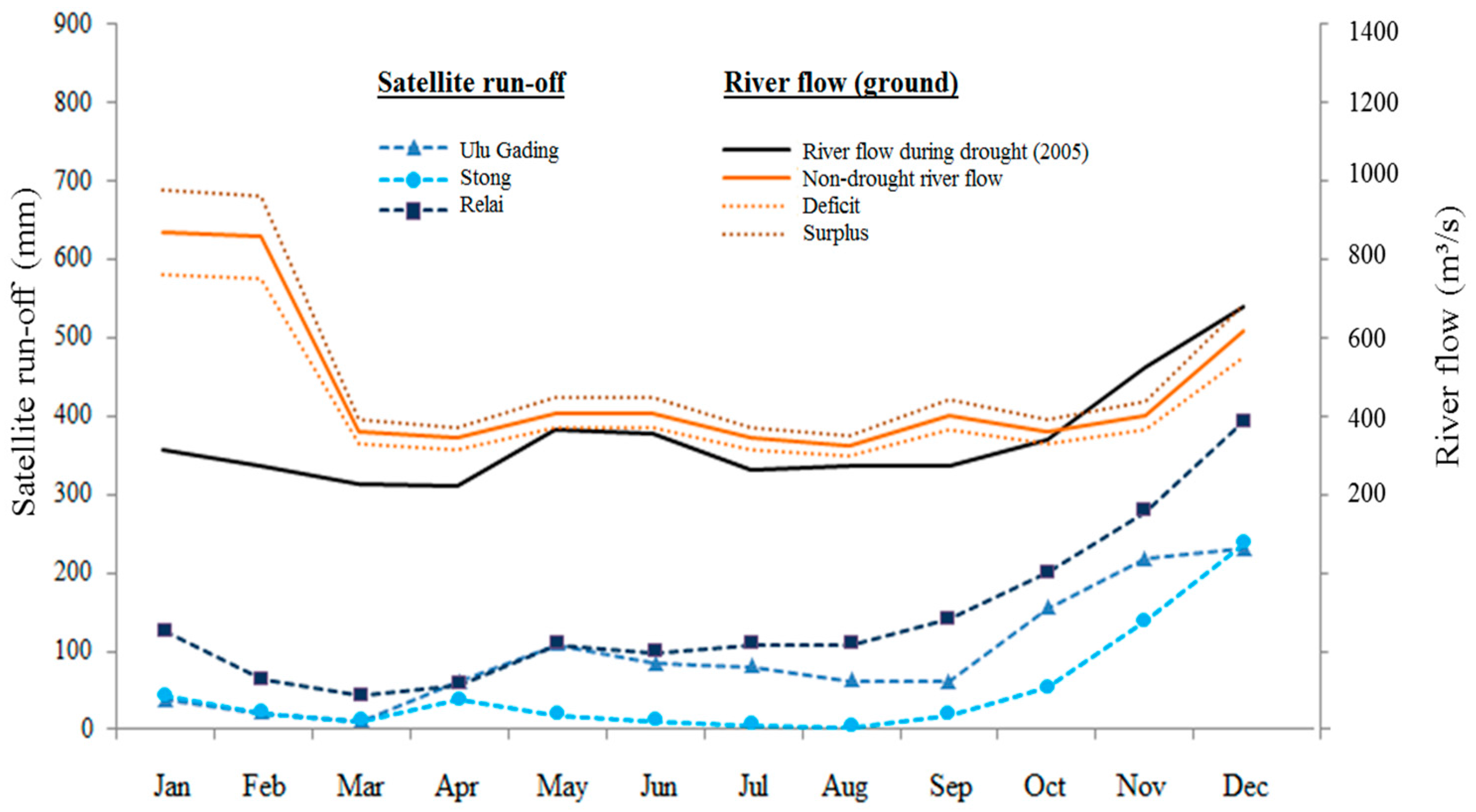
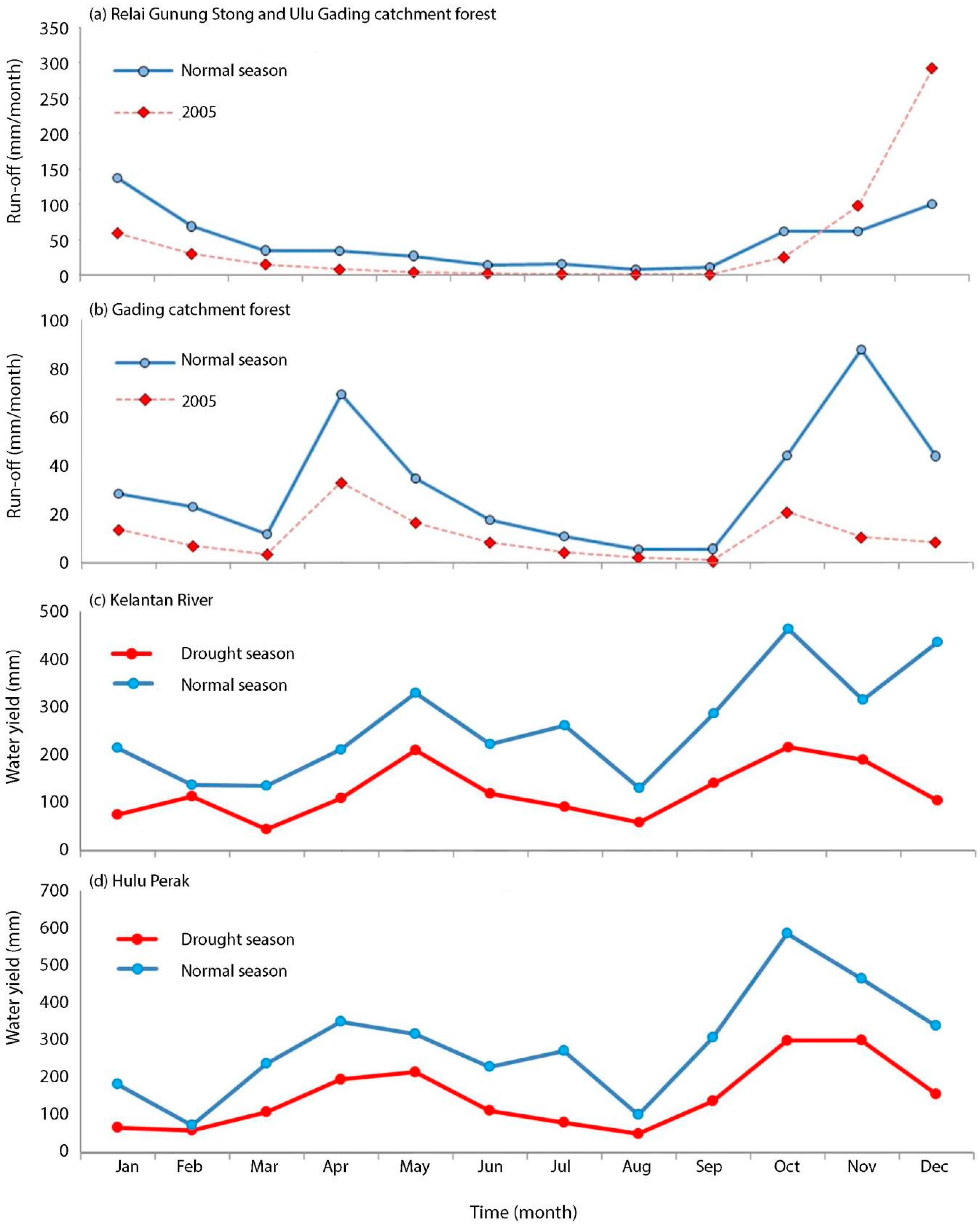
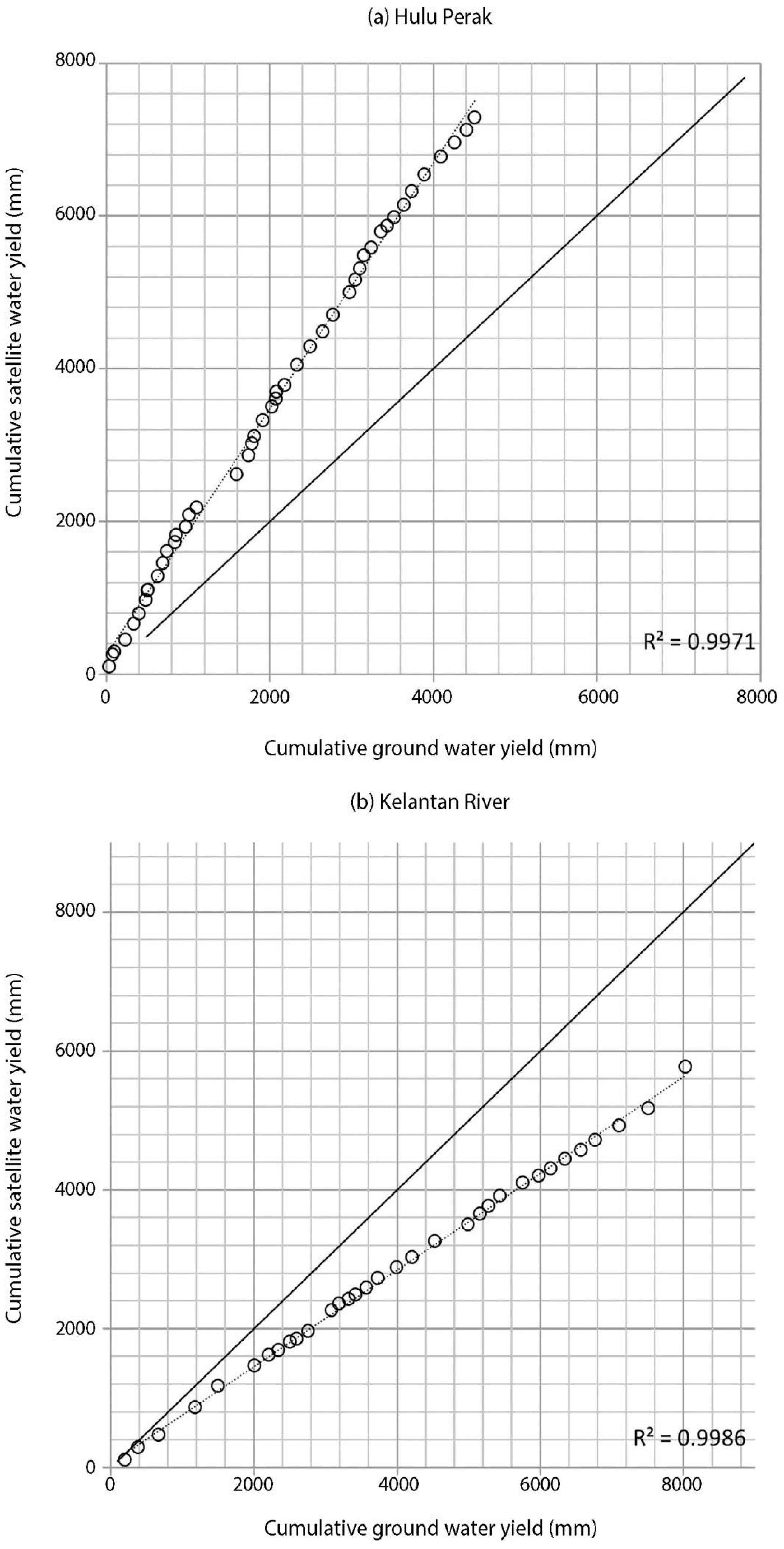
3.3.2. Comparison between Satellite-Based Run-Off and Actual River Flow
4. Discussion
5. Conclusions
Acknowledgments
Author Contributions
Conflicts of Interest
Appendix

| No. | ID | Name | Types | Region | Latitude (° ′ ′′) | Longitude (° ′ ′′) | Height (m.s.l) (m) |
|---|---|---|---|---|---|---|---|
| 1 | 48604 | Chuping | A | Northwest | 6 29 00 | 100 16 00 | 22 |
| 2 | 48600 | Langkawi | A | Northwest | 6 20 00 | 099 44 00 | 6.4 |
| 3 | 48603 | Alor Setar | A | Northwest | 6 12 00 | 100 44 00 | 4 |
| 4 | 48602 | Butterworth | A | Northwest | 5 28 00 | 100 23 00 | 2 |
| 5 | 41529 | Perai | A | Northwest | 5 21 00 | 100 24 00 | 1 |
| 6 | 48601 | Bayan Lepas | A | Northwest | 5 18 00 | 100 15 00 | 3 |
| 7 | 48674 | Mersing | A | East | 2 27 00 | 103 50 00 | 43.6 |
| 8 | 48642 | Batu Embun | A | East | 3 58 00 | 102 21 00 | 59 |
| 9 | 48657 | Kuantan | A | East | 3 47 00 | 103 13 00 | 15 |
| 10 | 48653 | Temerloh | A | East | 3 28 00 | 102 23 00 | 39 |
| 11 | 48649 | Muadzam Shah | A | East | 3 03 00 | 103 05 00 | 33 |
| 12 | 48618 | Kuala Terengganu | A | East | 5 23 00 | 103 06 00 | 5 |
| 13 | 48619 | Kuala Terengganu M.C. | A | East | 5 20 00 | 103 08 00 | 35 |
| 14 | 48615 | Kota Bharu | A | East | 6 10 00 | 102 17 00 | 4.6 |
| 15 | 48616 | Kuala Krai | A | East | 5 32 00 | 102 12 00 | 68.3 |
| 16 | 48661 | Ulu Chanis | B | East | 2 48 45 | 102 56 15 | N/A |
| 17 | 48625 | Ipoh | A | West | 4 35 00 | 101 06 00 | 39 |
| 18 | 48620 | Sitiawan | A | West | 4 13 00 | 101 42 00 | 7 |
| 19 | 48623 | Lubuk Merbau | A | West | 4 48 00 | 100 54 00 | 77.2 |
| 20 | 48631 | Cameron Highlands | A | West (Highland) | 4 28 00 | 101 23 00 | 1472 |
| 21 | 48647 | Subang | A | West | 3 07 00 | 101 33 00 | 17 |
| 22 | 48648 | Petaling Jaya | A | West | 3 06 00 | 101 39 00 | 45.7 |
| 23 | 48650 | Sepang KLIA | A | West | 2 43 00 | 101 42 00 | 16.3 |
| 24 | 48658 | Ldg. Sungkai | B | West | 3 58 15 | 101 18 00 | N/A |
| 25 | 48665 | Melaka | A | Southwest | 2 16 00 | 102 15 00 | 9 |
| 26 | 48672 | Kluang | A | Southwest | 2 01 00 | 103 19 00 | 88.1 |
| 27 | 48670 | Batu Pahat | A | Southwest | 1 52 00 | 102 59 00 | 6.3 |
| 28 | 48679 | Senai | A | Southwest | 1 38 00 | 103 40 00 | 37.8 |
| 29 | 5721442 | Sg. Kelantan | C | East | 5 45 45 | 102 09 00 | N/A |
| 30 | 4809443 | Sg. Perak | C | West | 4 49 10 | 100 57 55 | N/A |
References
- Wilhite, D.; Svoboda, M.; Hayes, M. Understanding the complex impacts of drought: A key to enhancing drought mitigation and preparedness. Water Resour. Manag. 2007, 21, 763–774. [Google Scholar] [CrossRef]
- Du, L.; Tian, Q.; Yu, T.; Meng, Q.; Jancso, T.; Udvardy, P.; Huang, Y. A Comprehensive drought monitoring method integrating MODIS and TRMM data. Int. J. Appl. Earth Obs. Geoinform. 2013, 23, 245–253. [Google Scholar] [CrossRef]
- Zargar, A.; Sadiq, R.; Naser, B.; Khan, F.I. A review of drought indices. Environ. Rev. 2011, 19, 333–349. [Google Scholar] [CrossRef]
- Rhee, J.; Im, J.; Park, S. Regional drought monitoring based on multi-sensor remote sensing. In Remote Sensing of Water Resources, Disasters, and Urban Studies; Thenkabail, D., Ed.; CRC Press: Florida, USA, 2015; pp. 401–415. [Google Scholar]
- Vyas, S.S.; Bhattacharya, B.K.; Nigam, R.; Guhathakurta, P.; Ghosh, K.; Chattopadhyay, N.; Gairola, R.M. A combined deficit index for regional agricultural drought assessment over semi-arid tract of India using geostationary meteorological satellite data. Int. J. Appl. Earth Obs. Geoinform. 2015, 39, 28–39. [Google Scholar] [CrossRef]
- Anderson, M.C.; Allen, R.G.; Morse, A.; Kustas, W.P. Use of Landsat Thermal Imagery in monitoring evapotranspiration and managing water resources. Remote Sens. Environ. 2012, 122, 50–65. [Google Scholar] [CrossRef]
- Wilhite, D.A.; Sivakumar, M.V.K.; Pulwarty, R. Managing drought risk in a changing climate: The role of national drought policy. Weather Clim. Extremes 2014, 3, 4–13. [Google Scholar] [CrossRef]
- Rossi, G.; Vega, T.; Bonaccorso, B. Methods and Tools for Drought Analysis and Management; Springer: Dordrecht, The Netherlands, 2007; p. 421. [Google Scholar]
- Miyan, M.A. Droughts in Asian least developed countries: Vulnerability and sustainability. Weather Clim. Extremes 2015, 7, 8–23. [Google Scholar] [CrossRef]
- Wilhite, D.A. Drought as a Natural Hazard: Concepts and Definitions; Routledge: London, UK, 2000; p. 18. [Google Scholar]
- Mildrexler, D.; Yang, Z.; Cohen, W.B.; Bell, D.M. A forest vulnerability index based on drought and high temperatures. Remote Sens. Environ. 2016, 173, 314–325. [Google Scholar] [CrossRef]
- Nam, W.; Hayes, M.J.; Svoboda, M.D.; Tadesse, T.; Wilhite, D.A. Drought Hazard assessment in the context of climate change for South Korea. Agric. Water Manag. 2015, 160, 106–117. [Google Scholar] [CrossRef]
- Delhomme, J.P. Kriging in the Hydrosciences. Adv. Water Resour. 1978, 1, 251–266. [Google Scholar] [CrossRef]
- Tao, T.; Chocat, B.; Liu, S.; Xin, K. Uncertainty Analysis of interpolation methods in rainfall spatial distribution—A case of small catchment in Lyon. J. Water Resour. Prot. 2009, 1, 136–144. [Google Scholar] [CrossRef]
- Swain, S.; Wardlow, B.D.; Narumalani, S.; Tadesse, T.; Callahan, K. Assessment of vegetation response to drought in Nebraska using Terra-MODIS land surface temperature and normalized difference vegetation index. GISci. Remote Sens. 2011, 48, 432–455. [Google Scholar] [CrossRef]
- Aghakouchak, A.; Farahmand, A.; Melton, F.S.; Teixeira, J.; Anderson, M.C.; Wardlow, B.D.; Hain, C.R. Remote sensing of drought: Progress, challenges and opportunities. Rev. Geophys. 2015, 53, 452–480. [Google Scholar] [CrossRef]
- McVicar, T.R.; Jupp, D.L.B. The current and potential operational uses of remote sensing to aid decisions on drought exceptional circumstances in Australia: A review. Agric. Syst. 1998, 57, 399–468. [Google Scholar] [CrossRef]
- Goerner, A.; Reichstein, M.; Rambal, S. Tracking seasonal drought effects on ecosystem light use efficiency with satellite-based PRI in a Mediterranean forest. Remote Sens. Environ. 2009, 113, 1101–1111. [Google Scholar] [CrossRef]
- Yao, Y.; Liang, S.; Qin, Q.; Wang, K.; Zhao, S. Monitoring global land surface drought based on an improved evapotranspiration model. Int. J. Appl. Earth Obs. Geoinform. 2011, 13, 447–457. [Google Scholar] [CrossRef]
- Mu, Q.; Zhao, M.; Kimball, J.S.; McDowell, N.G.; Running, S.W. A remotely sensed global terrestrial drought severity index. Bull. Am. Meteor. Soc. 2013, 94, 83–98. [Google Scholar] [CrossRef]
- Yirdaw, S.Z.; Snelgrove, K.R.; Agboma, C.O. GRACE satellite observations of terrestrial moisture changes for drought characterization in the Canadian Prairie. J. Hydrol. 2008, 356, 84–92. [Google Scholar] [CrossRef]
- Swenson, S.; Wahr, J.; Milly, P.C.D. Estimated accuracies of regional water storage variations inferred from the gravity recovery and climate experiment (GRACE). Water Resour. Res. 2003, 39. [Google Scholar] [CrossRef]
- Wang, L.; Qu, J.J.; Hao, X. Forest fire detection using the normalized multi-band drought index (NMDI) with satellite measurements. Agric. For. Meteorol. 2008, 148, 1767–1776. [Google Scholar] [CrossRef]
- Rahimzadeh Bajgiran, P.; Darvishsefat, A.A.; Khalili, A.; Makhdoum, M.F. Using AVHRR-based vegetation indices for drought monitoring in the northwest of Iran. J. Arid Environ. 2008, 72, 1086–1096. [Google Scholar] [CrossRef]
- Park, S.; Im, J.; Jang, E.; Rhee, J. Drought assessment and monitoring through blending of multi-sensor indices using machine learning approaches for different climate regions. Agric. For. Meteorol. 2016, 216, 157–169. [Google Scholar] [CrossRef]
- Sheffield, J.; Goteti, G.; Wood, E.F. Development of a 50-year high-resolution global dataset of meteorological forcings for land surface modeling. J. Clim. 2006, 19, 3088–3111. [Google Scholar] [CrossRef]
- Zhou, T.; Nijssen, B.; Huffman, G.J.; Lettenmaier, D.P. Evaluation of real-time satellite precipitation data for global drought monitoring. J. Hydrometeor 2014, 15, 1651–1660. [Google Scholar] [CrossRef]
- Melendez-Pastor, I.; Navarro-Pedreño, J.; Gómez, I.; Koch, M. Detecting drought induced environmental changes in a Mediterranean wetland by remote sensing. Appl. Geogr. 2010, 30, 254–262. [Google Scholar] [CrossRef]
- Rojas, O.; Vrieling, A.; Rembold, F. Assessing drought probability for agricultural areas in Africa with coarse resolution remote sensing imagery. Remote Sens. Environ. 2011, 115, 343–352. [Google Scholar] [CrossRef]
- Milewski, A.; Elkadiri, R.; Durham, M. Assessment and comparison of TMPA satellite precipitation products in varying climatic and topographic regimes in Morocco. Remote Sens. 2015, 7, 5697–5717. [Google Scholar] [CrossRef]
- Sahoo, A.K.; Sheffield, J.; Pan, M.; Wood, E.F. Evaluation of the tropical rainfall measuring mission multi-satellite precipitation analysis (TMPA) for assessment of large-scale meteorological drought. Remote Sens. Environ. 2015, 159, 181–193. [Google Scholar] [CrossRef]
- Nichol, J.E.; Abbas, S. Integration of remote sensing datasets for local scale assessment and prediction of drought. Sci. Total Environ. 2015, 505, 503–507. [Google Scholar] [CrossRef] [PubMed]
- AghaKouchak, A.; Mehran, A.; Norouzi, H.; Behrangi, A. Systematic and random error components in satellite precipitation data sets. Geophys. Res. Lett. 2012, 39. [Google Scholar] [CrossRef]
- Oki, T.; Musiake, K. Seasonal change of the diurnal cycle of precipitation over Japan and Malaysia. J. Appl. Meteorol. 1994, 33, 1445–1463. [Google Scholar] [CrossRef]
- Wang, Y.; Herzschuh, U. Reassessment of holocene vegetation change on the upper Tibetan Plateau using the pollen-based REVEALS model. Rev. Palaeobot. Palynol. 2011, 168, 31–40. [Google Scholar] [CrossRef]
- Houborg, R.; Rodell, M.; Li, B.; Reichle, R.; Zaitchik, B.F. Drought indicators based on model-assimilated gravity recovery and climate experiment (GRACE) terrestrial water storage observations. Water Resour. Res. 2012, 48. [Google Scholar] [CrossRef]
- Wong, C.L.; Venneker, R.; Uhlenbrook, S.; Jamil, A.B.M.; Zhou, Y. Variability of rainfall in Peninsular Malaysia. Hydrol. Earth Syst. Sci. 2009, 6, 5471–5503. [Google Scholar] [CrossRef]
- Malaysian Meteorological Department. Climate Change Scenarios for Malaysia 2001–2099; Malaysian Meteorological Department: Selangor, Malaysia, 2009. [Google Scholar]
- Climate Prediction Center. Available online: http://www.cpc.ncep.noaa.gov/products/analysis_monitoring/ensostuff/ensoyears.shtml (accessed on 15 May 2016).
- Thornthwaite, C.W.; Mather, J.R. The Water Balance; Drexel Institute of Technology, Laboratory of Climatology: Centerton, NJ, USA, 1955; p. 104. [Google Scholar]
- Mahmud, M.R.; Numata, S.; Matsuyama, H.; Hosaka, T.; Hashim, M. Assessment of effective seasonal downscaling of TRMM precipitation data in Peninsular Malaysia. Remote Sens. 2015, 7, 4092–4111. [Google Scholar] [CrossRef]
- Kleidon, A.; Heimann, M. A method of determining rooting depth from a terrestrial biosphere model and its impacts on the global water and carbon cycle. Glob. Chang. Biol. 1998, 4, 275–286. [Google Scholar] [CrossRef]
- Hydrology and Water Resources Division Department of Irrigation and Drainage Malaysia. Drought Report of Peninsular Malaysia; Hydrology and Water Resources Division Department of Irrigation and Drainage Malaysia: Lumpur, Malaysia, 2005. [Google Scholar]
- Goddard Earth Sciences Data and Information Services Center. Available online: http://mirador.gsfc.nasa.gov/cgi-bin/mirador/presentNavigation.pl?tree=project&project=TRMM (accessed on 15 May 2016).
- Mu, Q.Z.; Zhao, M.S.; Running, S.W. Improvements to a MODIS global terrestrial evapotranspiration algorithm. Remote Sens. Environ. 2011, 115, 1781–1800. [Google Scholar] [CrossRef]
- Bastiaanssen, W.G.M.; Ahmad, M.D.; Chemin, Y. Satellite surveillance of evaporative depletion across the Indus Basin. Water Resour. Res. 2002, 38, 1273–1282. [Google Scholar] [CrossRef]
- Nadzri, M.I.; Hashim, M. Validation of satellite precipitation using TRMM recent products. In Proceedings of the 34th Asian Conference on Remote Sensing, Bali, Indonesia, 20–24 October 2013; pp. 1992–1999.
- Nadzri, M.I.; Hashim, M. Validation of MODIS data for localized spatio-temporal evapotranspiration mapping. IOP Conf. Ser. Earth Environ. Sci. 2014, 18. [Google Scholar] [CrossRef]
- Mu, Q.; Heinsch, F.A.; Zhao, M.; Running, S.W. Development of a global evapotranspiration algorithm based on MODIS and global meteorology data. Remote Sens. Environ. 2007, 111, 519–536. [Google Scholar] [CrossRef]
- Hao, C.; Zhang, J.; Yao, F. Combination of multi-sensor remote sensing data for drought monitoring over Southwest China. Int. J. Appl. Earth Obs. Geoinform. 2015, 35, 270–283. [Google Scholar] [CrossRef]
- Bolten, J.D.; Crow, W.T.; Zhan, X.; Jackson, T.J.; Reynolds, C.A. Evaluating the utility of remotely sensed soil moisture retrievals for operational agricultural drought monitoring. IEEE J. Sel. Top. Appl. Earth Obs. Remote Sens. 2010, 3, 57–66. [Google Scholar] [CrossRef]
- Van Dijk, A.I.J.M.; Beck, H.E.; Crosbie, R.S.; de Jeu, R.A.M.; Liu, Y.Y.; Podger, G.M.; Timbal, B.; Viney, N.R. The millennium drought in Southeast Australia (2001–2009): Natural and human causes and implications for water resources, ecosystems, economy, and society. Water Resour. Res. 2013, 49, 1040–1057. [Google Scholar] [CrossRef]
- Brown, J.F.; Wardlow, B.D.; Tadesse, T.; Hayes, M.J.; Reed, B.C. The vegetation drought response index (VegDRI): A new integrated approach for monitoring drought stress in vegetation. GISci. Remote Sens. 2008, 45, 16–46. [Google Scholar] [CrossRef]
- Cáceres, M.D.; Martínez-Vilalta, J.; Coll, L.; Llorens, P.; Casals, P.; Poyatos, R.; Pausas, J.G.; Brotons, L. Coupling a water balance model with forest inventory data to predict drought stress: The role of forest structural changes vs. climate changes. Agric. For. Meteorol. 2015, 213, 77–90. [Google Scholar] [CrossRef]
- Xie, J.; Zha, T.; Zhou, C.; Jia, X.; Yu, H.; Yang, B.; Chen, J.; Zhang, F.; Wang, B.; Bourque, C.P.-A.; et al. Seasonal variation in ecosystem water use efficiency in an urban-forest reserve affected by periodic drought. Agric. For. Meteorol. 2016, 221, 142–151. [Google Scholar] [CrossRef]
- Yaduvanshi, A.; Srivastava, P.K.; Pandey, A.C. Integrating TRMM and MODIS satellite with socio-economic vulnerability for monitoring drought risk over a tropical region of India. Phys. Chem. Earth Parts A/B/C 2015, 83–84, 14–27. [Google Scholar] [CrossRef]
- Golian, S.; Mazdiyasni, O.; AghaKouchak, A. Trends in meteorological and agricultural droughts in Iran. Theor. Appl. Climatol. 2014, 119, 679–688. [Google Scholar] [CrossRef]
- Hoerling, M.; Kumar, A. The perfect ocean for drought. Science 2003, 299, 691–694. [Google Scholar] [CrossRef] [PubMed]
- Grimes, D.I.F.; Diop, M. Satellite-based rainfall estimation for river flow forecasting in Africa. I: Rainfall estimates and hydrological forecasts. Hydrol.l Sci. J. 2003, 48, 567–584. [Google Scholar] [CrossRef]
- Zin, W.Z.W.; Jemain, A.A.; Ibrahim, K. Analysis of drought condition and risk in Peninsular Malaysia using Standardised Precipitation Index. Theor. Appl. Climatol. 2013, 111, 559–568. [Google Scholar] [CrossRef]
- Tangang, F.T.; Juneng, L.; Salimun, E.; Sei, K.M.; Le, L.J.; Muhamad, H. Climate change and variability over Malaysia: Gaps in science and research information. Sains Malays. 2012, 41, 1355–1366. [Google Scholar]


| El Nino Episode | |
|---|---|
| Beginning | End |
| May 2002 | February 2003 |
| June 2004 | June 2005 |
| August 2006 | February 2007 |
| June 2009 | May 2010 |
| Region | No. of Gauges | Mean Monthly Rainfall (mm) Derived from | S/G ratio | |||
|---|---|---|---|---|---|---|
| Gauge | Uncalibrated TMPA | Calibrated TMPA | Uncalibrated | Calibrated | ||
| Northwest | 6 | 202.15 | 138.26 | 172.83 | 0.68 | 0.90 |
| East | 10 | 225.24 | 89.41 | 129.59 | 0.40 | 0.68 |
| Southwest | 3 | 167.59 | 98.42 | 131.23 | 0.59 | 0.79 |
| West | 9 | 210.21 | 149.87 | 187.34 | 0.71 | 0.92 |
| Peninsular | 28 | 201.3 | 118.99 | 155.25 | 0.60 | 0.82 |
| Station (ID) | Mean Ground Computed ET (mm/month) | Mean MODIS ET (mm/month) | Monthly S/G Ratio |
|---|---|---|---|
| Chuping (48604) | 147.3 | 205.4 | 1.4 |
| Alor Setar (48603) | 149.5 | 126.3 | 0.8 |
| Butterworth (48602) | 169.9 | 106.3 | 0.6 |
| K. Bharu (48615) | 135.6 | 119.0 | 0.9 |
| KualaTerengganu (48619) | 237.7 | 166.8 | 0.7 |
| Ipoh (48625) | 155.6 | 35.0 | 0.2 |
| Kuantan (48657) | 123.9 | 87.2 | 0.7 |
| Subang (48647) | 133.6 | 139.5 | 1.0 |
| Melaka (48665) | 132.8 | 79.7 | 0.6 |
| Senai (48679) | 129.5 | 60.9 | 0.5 |
| Run-off Deficit (%) | Land-Use (km2) | |||||||||
|---|---|---|---|---|---|---|---|---|---|---|
| Kelantan | Hulu Perak | |||||||||
| F | OP | P | R | O | F | OP | P | R | O | |
| 100–80 | 903 | 55 | 84 | 104 | 98 | 137 | N/A | N/A | N/A | N/A |
| 79–60 | 1508 | 60 | 58 | 160 | 61 | 542 | N/A | N/A | N/A | N/A |
| 59–40 | 1780 | 112 | 103 | 302 | 98 | 722 | N/A | N/A | N/A | N/A |
| 39–20 | 3837 | 419 | 482 | 902 | 328 | 1409 | N/A | N/A | N/A | N/A |
| <20 | 2510 | 121 | 234 | 533 | 172 | 453 | N/A | N/A | N/A | N/A |
© 2016 by the authors; licensee MDPI, Basel, Switzerland. This article is an open access article distributed under the terms and conditions of the Creative Commons Attribution (CC-BY) license (http://creativecommons.org/licenses/by/4.0/).
Share and Cite
Hashim, M.; Reba, N.M.; Nadzri, M.I.; Pour, A.B.; Mahmud, M.R.; Mohd Yusoff, A.R.; Ali, M.I.; Jaw, S.W.; Hossain, M.S. Satellite-Based Run-Off Model for Monitoring Drought in Peninsular Malaysia. Remote Sens. 2016, 8, 633. https://doi.org/10.3390/rs8080633
Hashim M, Reba NM, Nadzri MI, Pour AB, Mahmud MR, Mohd Yusoff AR, Ali MI, Jaw SW, Hossain MS. Satellite-Based Run-Off Model for Monitoring Drought in Peninsular Malaysia. Remote Sensing. 2016; 8(8):633. https://doi.org/10.3390/rs8080633
Chicago/Turabian StyleHashim, Mazlan, Nadzri M. Reba, Muhammad I. Nadzri, Amin B. Pour, Mohd R. Mahmud, Abdull R. Mohd Yusoff, Mohamad I. Ali, S. W. Jaw, and Mohammad S. Hossain. 2016. "Satellite-Based Run-Off Model for Monitoring Drought in Peninsular Malaysia" Remote Sensing 8, no. 8: 633. https://doi.org/10.3390/rs8080633