Remote Sensing Open Access Journal: Increasing Impact through Quality Publications

Remote Sensing, an open access journal ( https://www.mdpi.com/journal/remotesensing) has grown at rapid pace since its first publication five years ago, and has acquired a strong reputation. It is a “pathfinder” being the first open access journal in remote sensing. For those academics who were used to waiting a year or two for their peer-reviewed scientific work to be reviewed, revised, edited, and published, Remote Sensing offers a publication time frame that is unheard of (in most cases, less than four months). However, we do this after multiple peer-reviews, multiple revisions, much editorial scrutiny and decision-making, and professional editing by an editorial office before a paper is published online in our tight time frame, bringing a paradigm shift in scientific publication. As a result, there has been a swift increase in submissions of higher and higher quality manuscripts from the best authors and institutes working on Remote Sensing, Geographic Information Systems (GIS), Global Navigation Satellite System (GNSS), GIScience, and all related geospatial science and technologies from around the world. The purpose of this editorial is to update everyone interested in Remote Sensing on the progress made over the last year, and provide an outline of our vision for the immediate future.
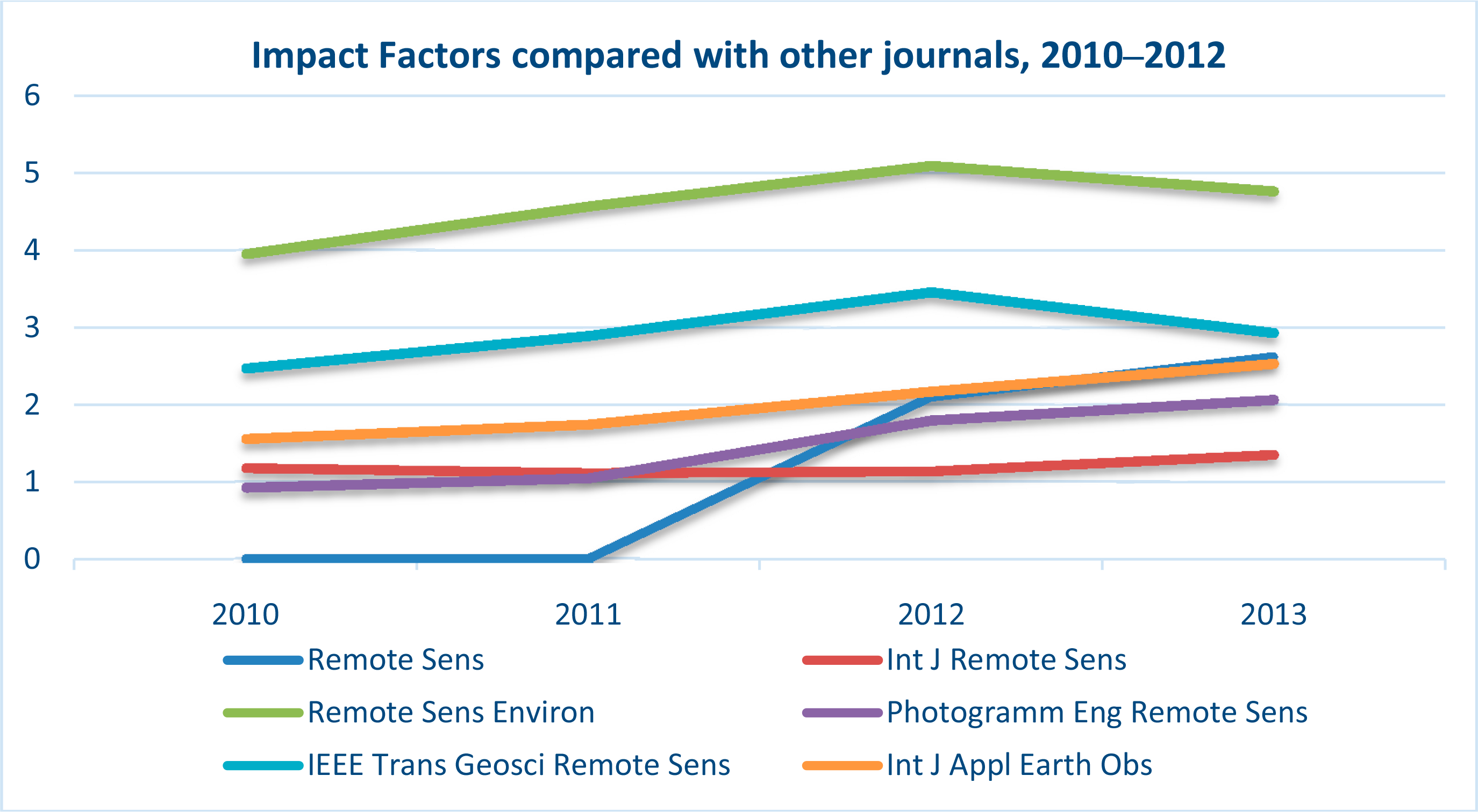
Having started in March 2009, Remote Sensing currently has an impact factor of 2.623 (Rank 6 out of 27 international journals published in Remote Sensing, GIS, and Spatial Science). A comparison with some of best remote sensing journals (Figure 1) shows the rapid gains made by Remote Sensing. In 2013, we received 650 articles for peer-review, of which we accepted 280 (43%), rejecting the rest 57% (Table 1). From 24 papers published in January 2013, the number increased to 39 in December 2013. There has been a further, highly significant increase in these numbers in 2014. For example, 216 papers were under consideration for publication in just two recent months, April and May, of which we accepted and published 45 in April and 52 in May, a total of 97 (45%). The 216 papers were submitted at various points over previous months and were in for decision during the two months mentioned. What this means is that, in the future, we can expect over 100 papers awaiting decisions every month. Handling and maintaining quality peer-review and publication is a major task that requires coordination, cooperation, enthusiasm, and a sense of service amongst the publication staff. I want to give readers an overview of how we handle this process. First, Remote Sensing has two editorial offices: one in Basel, Switzerland and another in Beijing, China. Once the authors submit the manuscript online, the editorial office processes the papers and: (a) sends them to peer-review; or (b) returns them to the author without review (when the quality is poor). For those manuscripts selected for peer-review, three to six reviewers are typically found for every manuscript. Second, once the reviews are all submitted, the manuscripts and the reviews are sent to one of the Associate Editors (AEs) or Guest Editors (GEs) in the case of guest edited issues. The AEs and GEs look at the reviews and send the paper back to the editorial office with a decision: (i) revise, (ii) reject, (iii) accept. It is quite normal to ask for papers to be revised at this stage. The revision iteration from editorial office to AEs/GEs and back is, often, more than once (I have not seen a single paper come to me without being revised; and often it is revised multiple times). Third, when AEs/GEs make a final decision, all manuscripts await the Editor-in-Chief’s (EiC; myself) final decision. At this stage, the EiC considers the reviews as well as comments from AEs/GEs and again makes one of the decisions: (i) revise, (ii) reject, (iii) accept. My role is to ensure that certain standards are maintained and that we apply them uniformly across all manuscripts. Accepted papers will then be edited and processed by the MDPI editorial office headquarters in Basel, Switzerland. Therefore, every manuscript goes through five levels of scrutiny before a final decision is made. These five levels, to re-iterate, are:
Editorial office initial processing;
Three to six peer-reviews;
Associate Editors’ or Guest Editors’ scrutiny and decision to: (i) revise, (ii) accept, (iii) reject;
Editor-in-Chief (EiC) scrutiny and final decision to: (i) revise, (ii) accept, (iii) reject; and
Editorial office final processing for accepted papers.
In order to increase the quality of publications, handle large volume of decisions rationally, and to consider different areas of expertise, I invited a team of 10 highly distinguished scientists to join Remote Sensing as Associate Editors (AEs). The AEs, listed below, have already started making a significant contribution in scrutinizing the peer-review articles, evaluating them, and in making decisions.
Prof. Dr. Randolph H. Wynne, Department of Forest Resources and Environmental Conservation, Virginia Tech, Cheatham Hall, RM 319, 310 West Campus Dr, Blacksburg, VA 24061, USA
Dr. Richard Gloaguen, Remote Sensing Group, Helmholtz Institute Freiberg, TU Bergakademie Freiberg, Bernhard von-Cotta Str., 2, D-09599 Freiberg, Germany
Dr. Nicolas Baghdadi, Maison de la Télédétection, Irstea - UMR TETIS, 500 rue JF Breton, 34093 Montpellier Cedex 05, France
Prof. Dr. Clement Atzberger, Head Surveying, Remote Sensing & Land Information (IVFL), University of Natural Resources and Life Sciences, Vienna (BOKU), Peter Jordan Strasse 82, 1190 Vienna, Austria
Prof. Dr. Alfredo R. Huete, Plant Functional Biology and Climate Change Cluster, School of Environment, University of Technology Sydney, 15 Broadway Road Ultimo, NSW 2007, Australia
Dr. Richard Müller, German Meteorological Service CM-SAF, Frankfurter Straße 135, 63067 Offenbach, Germany
Prof. Dr. Janet Nichol, Department of Surveying and Geo-Informatics, The Hong Kong Polytechnic University, Hung Hom, Kowloon, Hong Kong
Dr. Ioannis Gitas, Laboratory of Forest Management and Remote Sensing, School of Forestry and Natural Environment, Aristotle University of Thessaloniki, Thessaloniki, Greece
Dr. Alexander A. Kokhanovsky, EUMETSAT, Eumetsat Allee 1, D-64295 Darmstadt, Germany
Prof. Dr. L. Monika Moskal, School of Environmental and Forest Sciences, College of the Environment, University of Washington, Box 352100, Seattle WA 98195-2100, USA.
With the addition of AEs, the general workload is more broadly distributed and every manuscript is given the time and expert scrutiny required for high quality peer-reviewed publication. I am very grateful to the AEs for their dedicated service.
In addition to AEs, we have other layers of expert scrutiny and support, particularly from the guest editors and editorial team members. Every year we create a number of special issues, see https://www.mdpi.com/journal/remotesensing/special_issues.
Each special issue is guest edited by one or more guest editors. Guest editors ensure an additional layer of scrutiny and expert inputs. A classic case of high standards achieved by special issues can be gauged by over 30 peer-reviewed papers published in the special issue on “Monitoring Global Vegetation with AVHRR NDVI3g Data (1981–2011)” by Prof. Ranga B. Myneni of the Boston University and Dr. Jorge E. Pinzón of NASA GSFC and Science Systems and Applications, Inc.: https://www.mdpi.com/journal/remotesensing/special_issues/monitoring_global.
Special issues not only require Guest Editor’s decisions, but are also further scrutinized by the editorial decision-making body (Managing Editor, AEs, and the Editor-in-Chief). A number of Editorial Team Members play an active role. Depending on the role played and contributions made, the guest editors and the editorial board members have an opportunity to be promoted to AEs. However, that would depend on a vacant AE position. We are likely to have a maximum cap of about 12–15 AEs at any one given time. This number may look big, but with increased emphasis on online publication and the leadership in this mode of publication by Remote Sensing, and the expected significant further increase in submissions, such a vision is likely to be appropriate.
The Remote Sensing derives a lot of strength from its energetic and resourceful editorial team consisting of Mr. Elvis Wang, Managing Editor, and his team members, and Dr. Martyn Rittman, Production Editor. They look into every detail of the publication process and have maintained a perfect publication scheduling.
Reviewers, especially the good ones, are at the crux of our success. We are incredibly grateful to all those reviewers for the hours they have spent on providing critical input. I have seen the dedication of so many reviewers, who constantly review papers and further scrutinize the revisions (often more than once). With the increasing pool of authors, we also now have an increasing pool of reviewers. In order to honor our reviewers, we have decided to publish the name of all reviewers at the end of the year for that particular year. We will also publish how many papers they reviewed and how many rounds of reviews there were. I would encourage all those who publish with us and/or in other remote sensing, GIS, and spatial sciences journals to offer your service as reviewers and contribute to this rewarding job. There are many hidden, important rewards for good reviewers that, in time, come through in various forms (e.g., membership of editorial boards, associate editorship, and recognition of your expertise in greater international forums including your own institutes). I have often wondered about those who refuse to find time to review papers, but expect their papers to be reviewed expeditiously! This model is not sustainable for every good professional. Of course, it is reasonable to decline to review papers when necessary, and when numerous journals put demands on your time; but you must also identify and choose the journals for which you want to serve as authors, reviewers, editors, and contributors in many other ways (e.g., guest edit a special issue).
Authors are the “heart and soul” of a journal. It is authorship that defines a journal. Who publishes in a journal? Why do they choose Remote Sensing over other journals? When one sees the quality of papers, authors, and the institutional affiliations of these authors, it gives you a fairly good idea of the standard of the journal itself. In this regard, I would ask the readers to take a look at the long list of manuscripts and authors in our more recent issues. It is clear that the journal is heading in a very positive direction.
I would like to mention one discordant note: there are times when I receive letters from authors after a rejection decision, appealing for reconsideration. Regarding such letters, it is important to note that the several layers of decision-making process that we abide by (as explained in previous paragraphs), almost certainly leads to a fair and honest decision. Request for reconsideration adds to our workload and is not helpful to authors in improving the quality of their papers. Rather, it is my best advice to such authors to spend additional time in revising and improving their manuscript and resubmit the paper as a new paper (rather than write to me) that will go through another fair and independent peer-review process. Ultimately, a paper that deserves to be published will get published.
Increasing submissions, in recent times, has meant there is stiff competition as to which articles are published and which are rejected. The result is that only good, very good or even the best papers are published. I expect the number of submissions to increase further in coming months and the natural outcome of this will be that only the best will get published. We will probably maintain about 50 articles per issue as a maximum, unless we see a further dramatic increase in submissions. As a move towards this, we have been constantly innovating and raising the bar. For example, we are tightening the rules on the paper standards, as it is clear from these additional instructions to authors that call for greater scrutiny and greater rigor: https://dl.dropboxusercontent.com/u/165068305/Remote_Sensing-Additional_Instructions.pdf. We have also added instructions for review papers where we expect greater depth and detail in order that such papers have a chance of publication. These instructions are in addition to our normal instructions to authors.
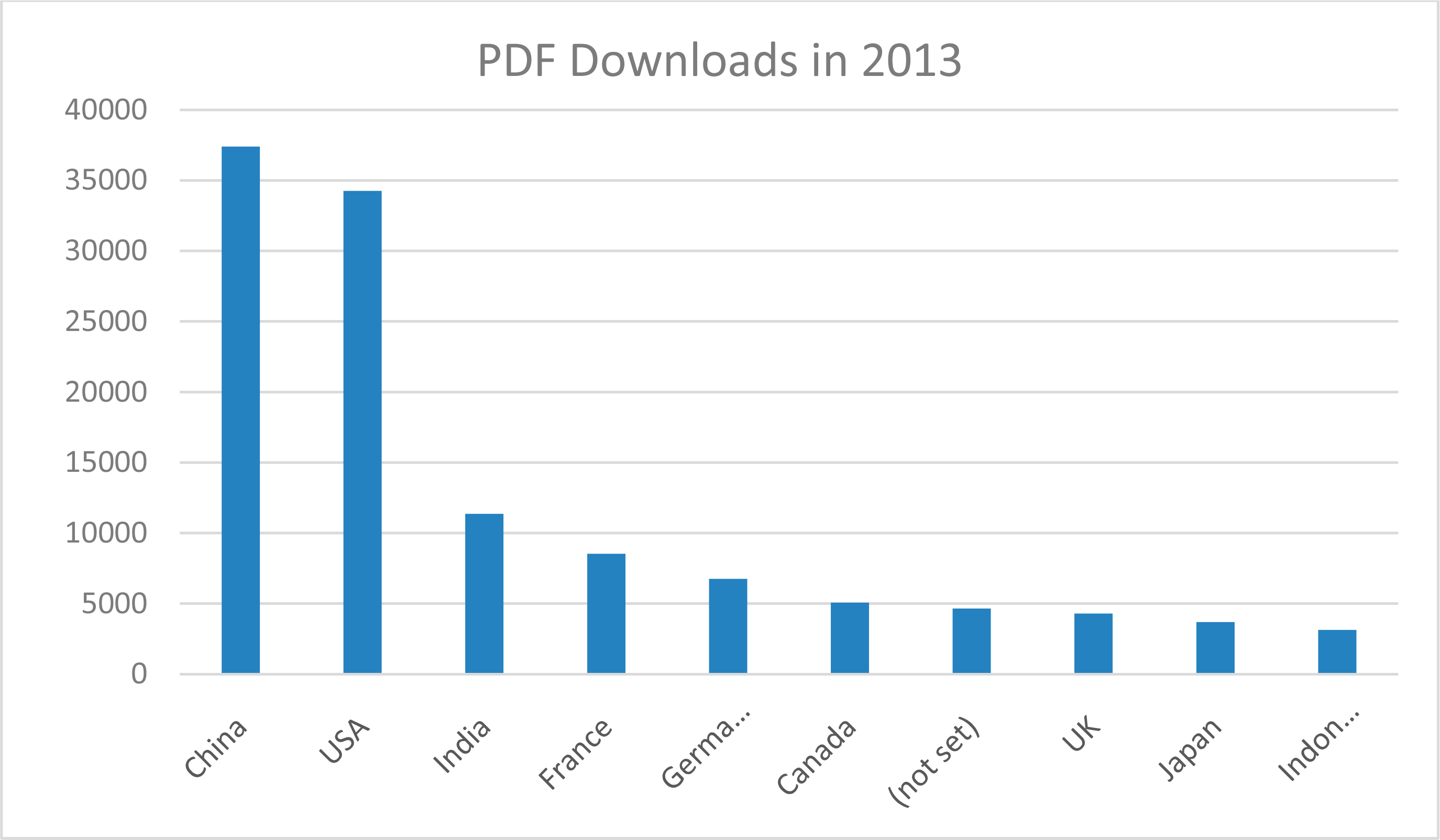
A good way to gauge the interest and importance of an online journal is to look at its online statistics of readership. In this regard, the total number of visits through Google to Remote Sensing manuscripts in 2013 was 175,157 (* “Visits” represent the number of visits to the journal homepage through Google.). The total number of pageviews is 490,669 while full text downloads from MDPI website was 417,372 in 2013, see Table 2. Figure 2 shows the geographical distribution of PDF downloads in 2013.
Increasing popularity of online open access (OA) publishing is inevitable. However, there are various models and debates on the future of publishing [1]. The two well-known models to OA publishing: gold (online open access model recommending pay-to-publish rather than pay-to-read), and green (archival route). The European Union-funded Finch report recommends “gold” open access with certain reservations. The United States Office of Science and Technology Policy (OSTP) released a memo in 2013 advocating that all federally funded research papers and data be made available free of cost from 12 months after publication. There are other models and ideas as well as descriptions of the pitfalls of the predatory nature of any of these publications that academics need to be aware of [1].
Acknowledgments
The figures, tables, and some of the information in this article are provided by Mr. Elvis Wang, Managing Editor of Remote Sensing.
References:
- Van Noorden, R. US science to be open to all. Nature 2013, 494, 414–415. [Google Scholar] [CrossRef]


| Submissions | Rejected before Review | Rejected after Review and Withdrawn | Published | |
|---|---|---|---|---|
| Jan | 70 | 22 | 14 | 24 |
| Feb | 67 | 25 | 7 | 24 |
| Mar | 47 | 16 | 9 | 24 |
| Apr | 55 | 26 | 7 | 25 |
| May | 53 | 20 | 8 | 27 |
| Jun | 50 | 13 | 6 | 25 |
| Jul | 66 | 32 | 7 | 23 |
| Aug | 67 | 25 | 8 | 23 |
| Sep | 94 | 29 | 17 | 25 |
| Oct | 85 | 22 | 14 | 30 |
| Nov | 78 | 20 | 12 | 35 |
| Dec | 73 | 26 | 8 | 39 |
Note:1.The rejection rate in 2013 is 56.92%: rejected/(accepted + archived): 370/(280 + 370) = 56.92%;2.2014 statistics are not provided here. However, in April and May alone we received 216 submissions, of which 43% of the papers were accepted for publications and the rest rejected.
| Quarter 1 | Quarter 2 | Quarter 3 | Quarter 4 | Total | |
|---|---|---|---|---|---|
| Publication numbers | 75 | 83 | 72 | 104 | 324 |
| Pageviews | 99,212 | 102,441 | 126,922 | 162,094 | 490,669 |
| PDF downloads | 81,849 | 101,709 | 123,347 | 110,467 | 417,372 |
© 2014 by the authors; licensee MDPI, Basel, Switzerland This article is an open access article distributed under the terms and conditions of the Creative Commons Attribution license (http://creativecommons.org/licenses/by/3.0/).
Share and Cite
Thenkabail, P.S. Remote Sensing Open Access Journal: Increasing Impact through Quality Publications. Remote Sens. 2014, 6, 7463-7468. https://doi.org/10.3390/rs6087463
Thenkabail PS. Remote Sensing Open Access Journal: Increasing Impact through Quality Publications. Remote Sensing. 2014; 6(8):7463-7468. https://doi.org/10.3390/rs6087463
Chicago/Turabian StyleThenkabail, Prasad S. 2014. "Remote Sensing Open Access Journal: Increasing Impact through Quality Publications" Remote Sensing 6, no. 8: 7463-7468. https://doi.org/10.3390/rs6087463