1. Introduction
Over the past several decades, urbanization has increased rapidly across the globe [
1]. Worldwide population, currently at just over seven billion, is expected to reach over nine billion by the middle of the 21st century [
2]. Agricultural land use has expanded to meet food demand and is expected to rise even more, putting increased pressure on the biosphere [
3,
4]. Dryland environments (arid, semi-arid, and dry sub-humid) are sensitive to environmental changes and comprise 38% of the global population [
5]. To keep up with the shifts to land change in dryland regions, land-use maps help monitor and study the social and institutional decisions to utilize land for different purposes. Land-use maps are also a fundamental part of land change science [
6] and a key source of data for studying urbanization and environmental change.
Monitoring land-use change relies on remote sensing products. Multiple methods can be used to classify land use from a remotely sensed image, but confusion can arise when heterogeneity of land covers obscure land-use classes [
7,
8]. One way to alleviate confusion between classifications is to incorporate more information from the images in such a way that takes advantage of human pattern recognition—something that is absent in automated classifiers. Object-based image analysis (OBIA) arose as a way to incorporate more of the pattern recognition capabilities of humans for improved classifications of land use and land cover [
9,
10]. The OBIA method integrates more information from the image than traditional pixel-based approaches, especially in urban systems [
11]. Objects are formed from pixels when spectrally or thematically similar neighboring pixels are grouped together using a segmentation algorithm [
12]. Objects formed from basal pixels have spatial properties similar to polygons. Once the pixels have formed meaningful objects, new options become available for classifying the image, including the option to use spatial properties [
13]. The incorporation of spatial information (or geometry), as well as traditional classification techniques, provides more flexibility to mappers.
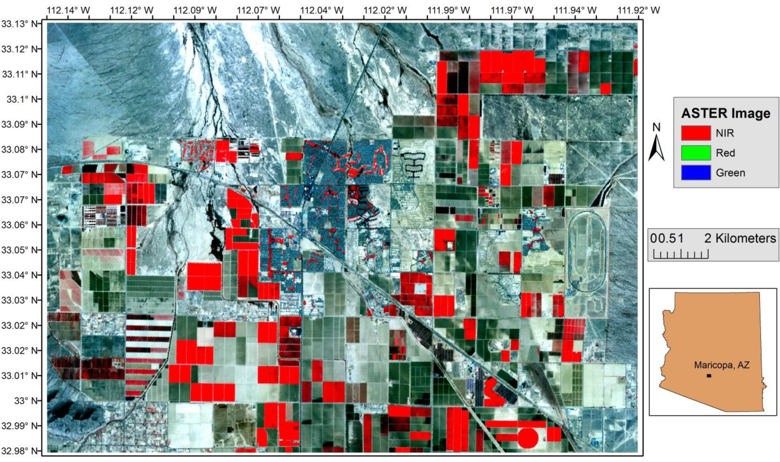
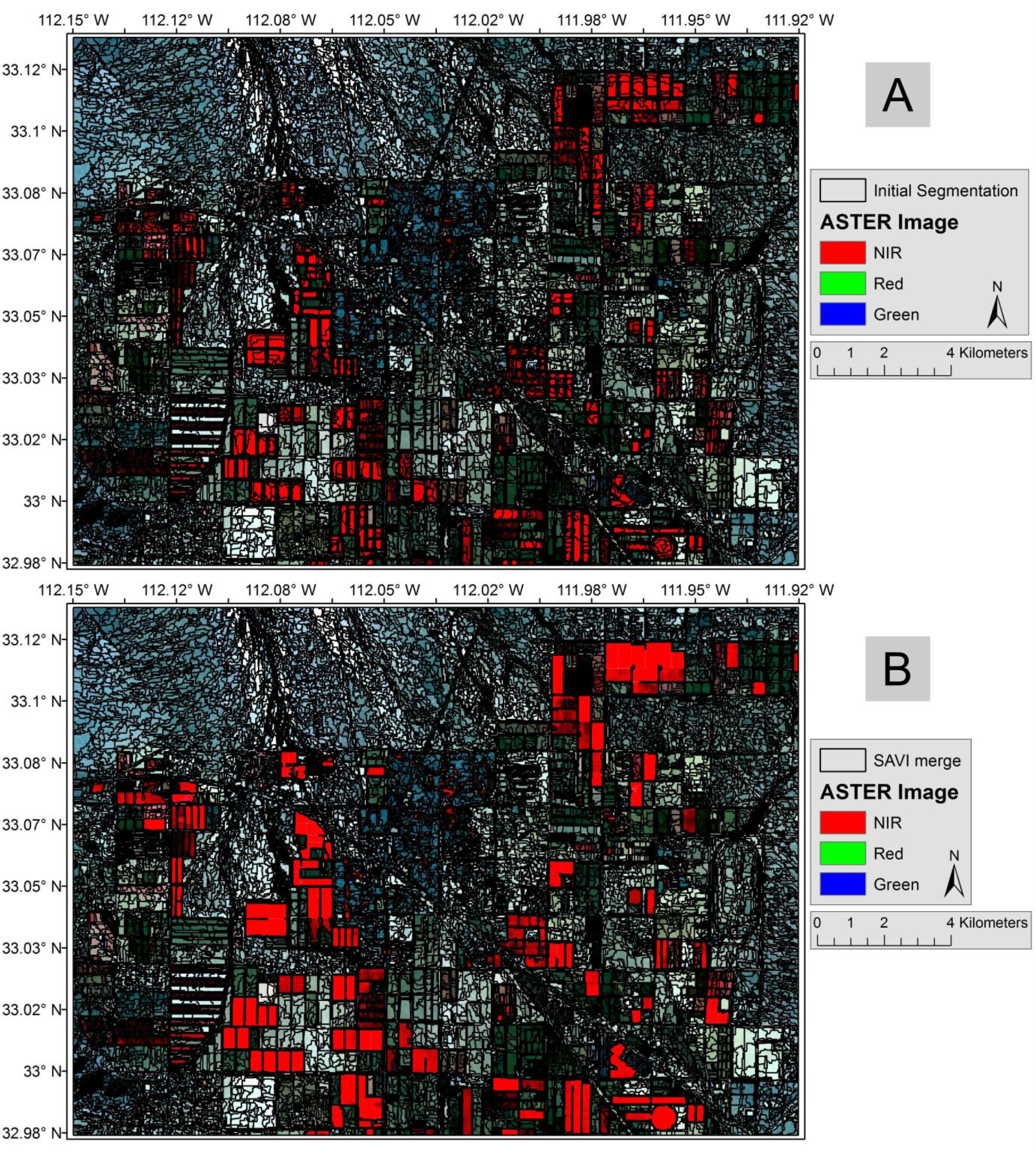
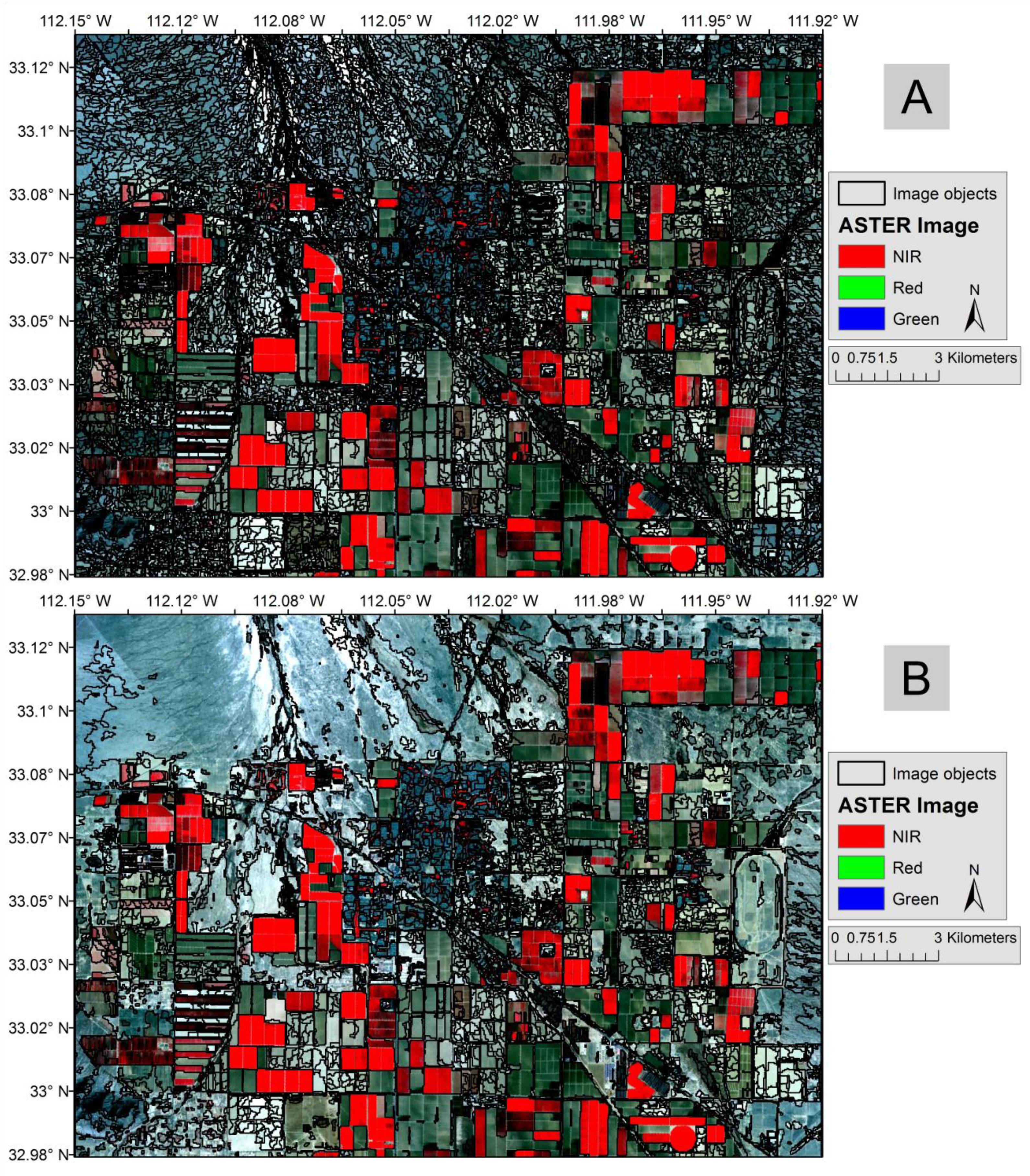
This paper presents research utilizing an OBIA approach to map land use in an arid region of Arizona, U.S.A., with ASTER (Advanced Spaceborne Thermal Emission and Reflection Radiometer) data in a mixed urban and agricultural landscape. Arid environments in the southwestern United States are sensitive to land-use decisions related to water consumption. These areas have also experienced rapid urbanization throughout the 20th and 21st centuries. The land-use map produced in this study was designed to help understand outdoor water usage as well as the spatial extent of urbanization and agriculture. Both spatial and spectral properties of objects were used to classify the image.
1.1. Aims and Objectives
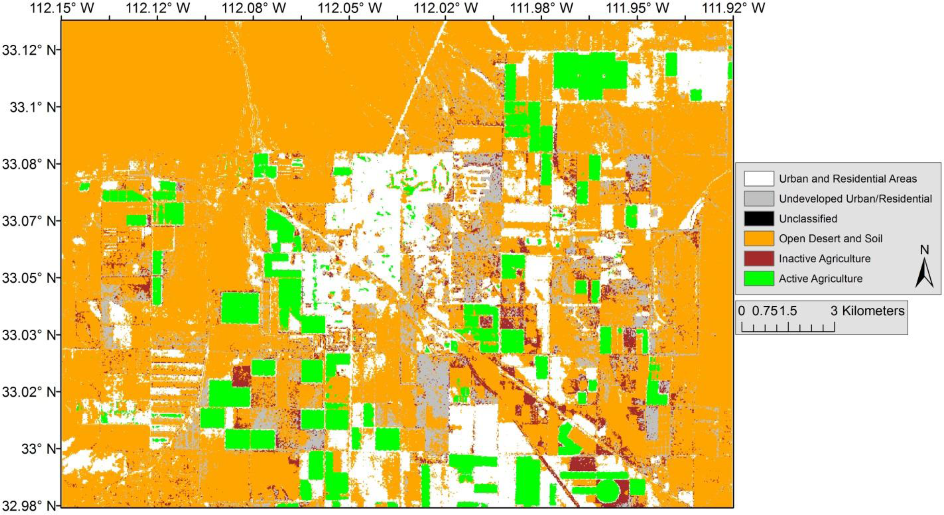
The study area was chosen based on the mixture of agriculture, urban/residential areas, and open desert, which is common to this part of Arizona. The primary aim is to develop an accurate map of meaningful land-use classifications that reflect the problems facing land systems in arid and semi-arid regions of the urbanizing southwestern United States, and to achieve this using information strictly within a single ASTER image. Six land-use types were used; they are listed below with their short names in parentheses (also
Table 1): Active Agriculture (active agriculture), Inactive or Fallow Agriculture (inactive agriculture), Recreational Green Zones (green space), Open Desert and Exposed Soil (open desert), Undeveloped Urban and Future High Density Residential Areas (undeveloped urban), and Urban and Residential Areas (developed urban).
These six classes are important today and are expected to be of great interest in future land-use studies. The “active” and “inactive agriculture” classes (class 1 and 2) represent land set aside for all agricultural activities, but the decision to split the super “agriculture” class into two separate classes gives land managers and planners better granularity on resource allocation, especially to help understand how water resources are used. The “green space” class (class 3) is a land-use category that indicates community and recreational “green space,” such as parks and golf courses, and is important for public water use, urban heat island mitigation, and community development. The “undeveloped urban” and “developed urban” classes (classes 5 and 6) show both the current urban extent and the planned urban extent. Delineating both of these urban classes will benefit land change studies, and offer insight about real estate economics and local effects of the recent slide in the housing market that occurred starting in 2008.
The second objective of this paper is to provide guidance for those conducting land-use studies in similar contexts. ASTER is an important sensor because it provides valuable VNIR and SWIR data (SWIR data prior to April 2008). OBIA has gained popularity in both land cover and land-use mapping in central Arizona because it performs well when compared to per-pixel methods [
14]. The methods in this study will hopefully offer suggestions for other researchers to consider when using OBIA for land-use mapping.
3. Results and Discussion
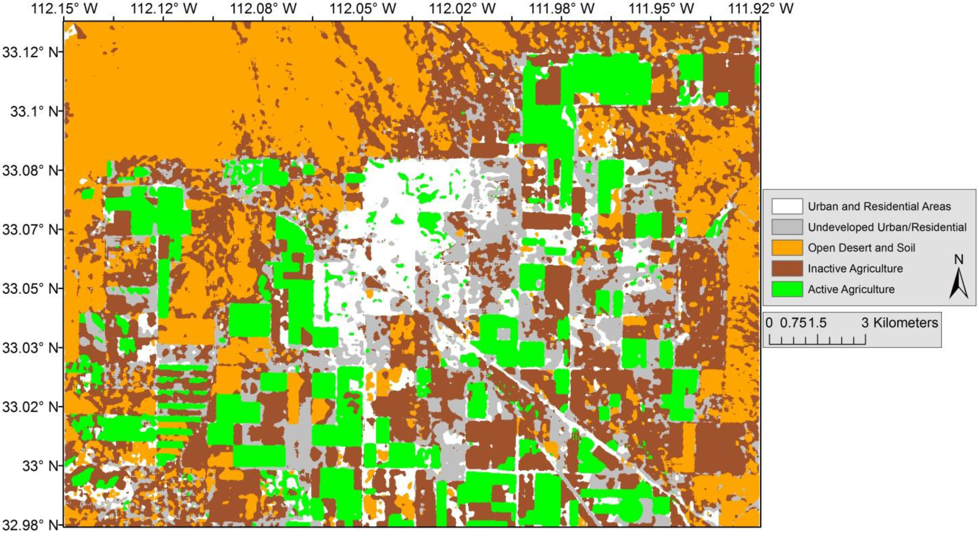
The results of the accuracy assessment for the OBIA (
Figure 10), supervised classification (
Figure 8), and unsupervised classification (
Figure 9) were compared (
Tables 2,
3, and
4). The OBIA method demonstrated higher accuracy than the supervised or unsupervised classification. The overall accuracy of the OBIA land-use map was 90.67%, with a Kappa of 0.8833. The overall accuracy of the unsupervised land-use map was 65.14%, with an overall Kappa of 0.5322. The accuracy of the supervised classification was 63.71%, with a Kappa of 0.513. Unsupervised classifications allocate classes to pixels based on the spectral difference between an arbitrary number of classes (30 for this study), whereas the supervised classification relies on signatures created from samples of different classes. The improved accuracy of the OBIA method over the supervised and unsupervised method is expected based on numerous studies showing that grouping pixels into objects can improve classification performance [
14,
40]. However, not all studies have demonstrated that OBIA always outperforms per-pixel approaches [
36], thus warranting further comparisons.
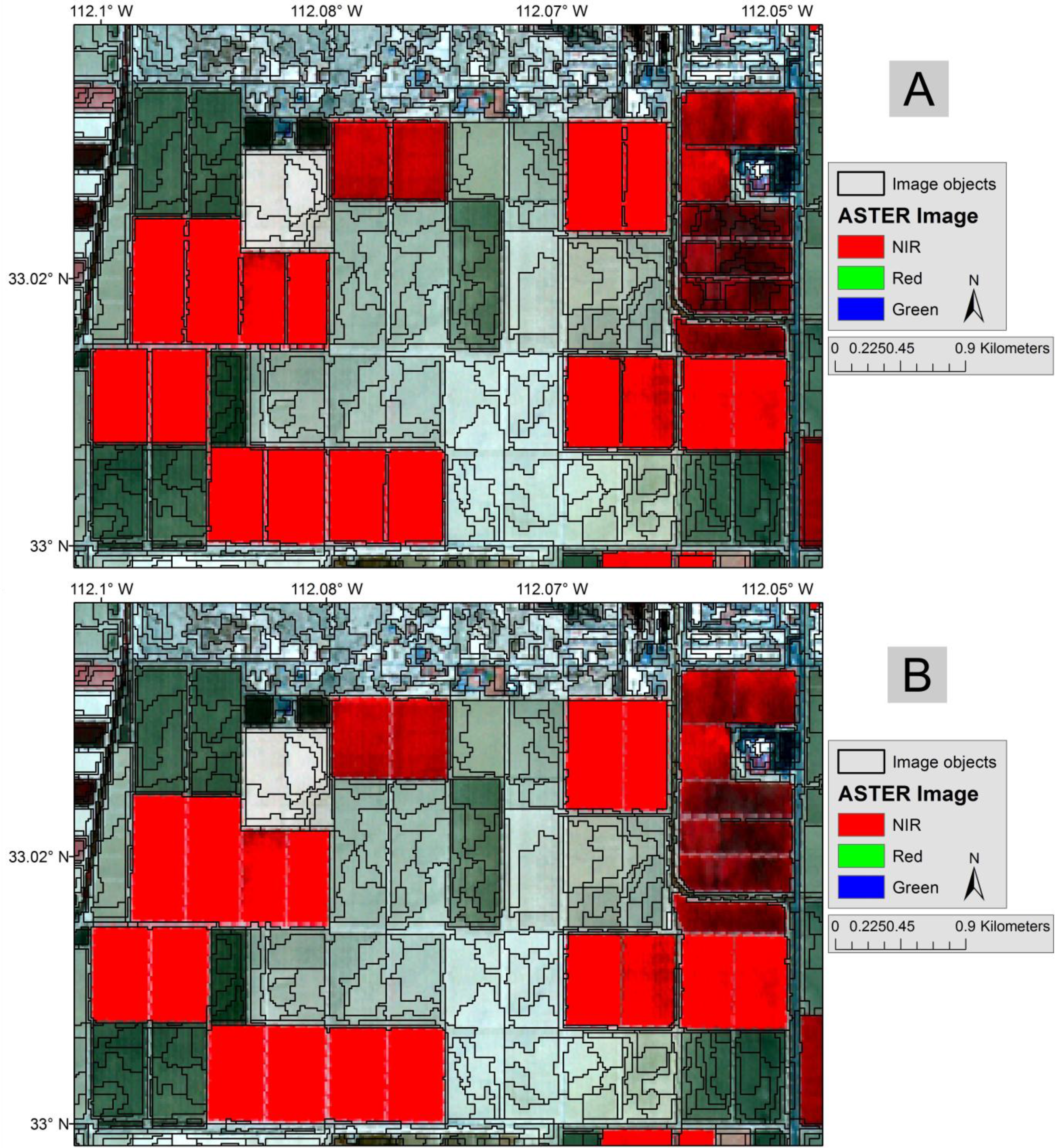
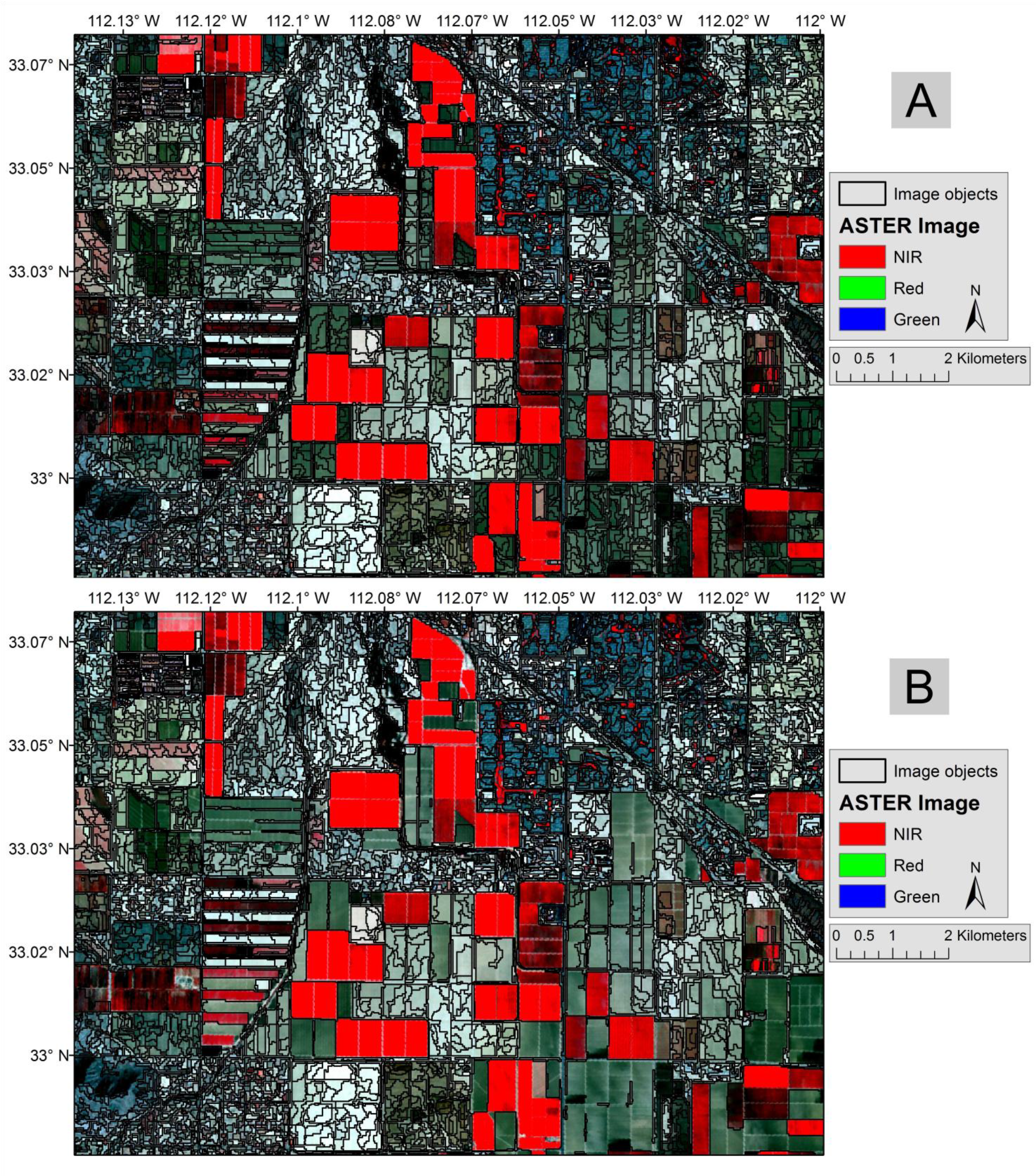
The unsupervised classification satisfactorily classified “active agriculture” (∼87% producers’ accuracy and ∼93% user’s accuracy), which compares to the OBIA method (∼81% producer’s and 100% user’s) and the supervised classification (78% producer’s and 100% user’s). The spectral properties of the vegetation make it easy to distinguish “active agriculture” from other land-use types. The morphing, merging, and growing of image objects, as well as using the size of the objects, helped to delineate “active agriculture” from other types of land uses in the OBIA method. It is possible in other study areas that agriculture may not be defined by size (e.g., small urban farm plots). If this is the case, other spatial information or geometry could assist in classifying agriculture. Shape parameters may help alleviate this problem, and could be an area for future exploration. Agriculture is distinctly square or circular in most applications; this characteristic could be exploited to automate classification of agriculture, no matter the size of the plots.
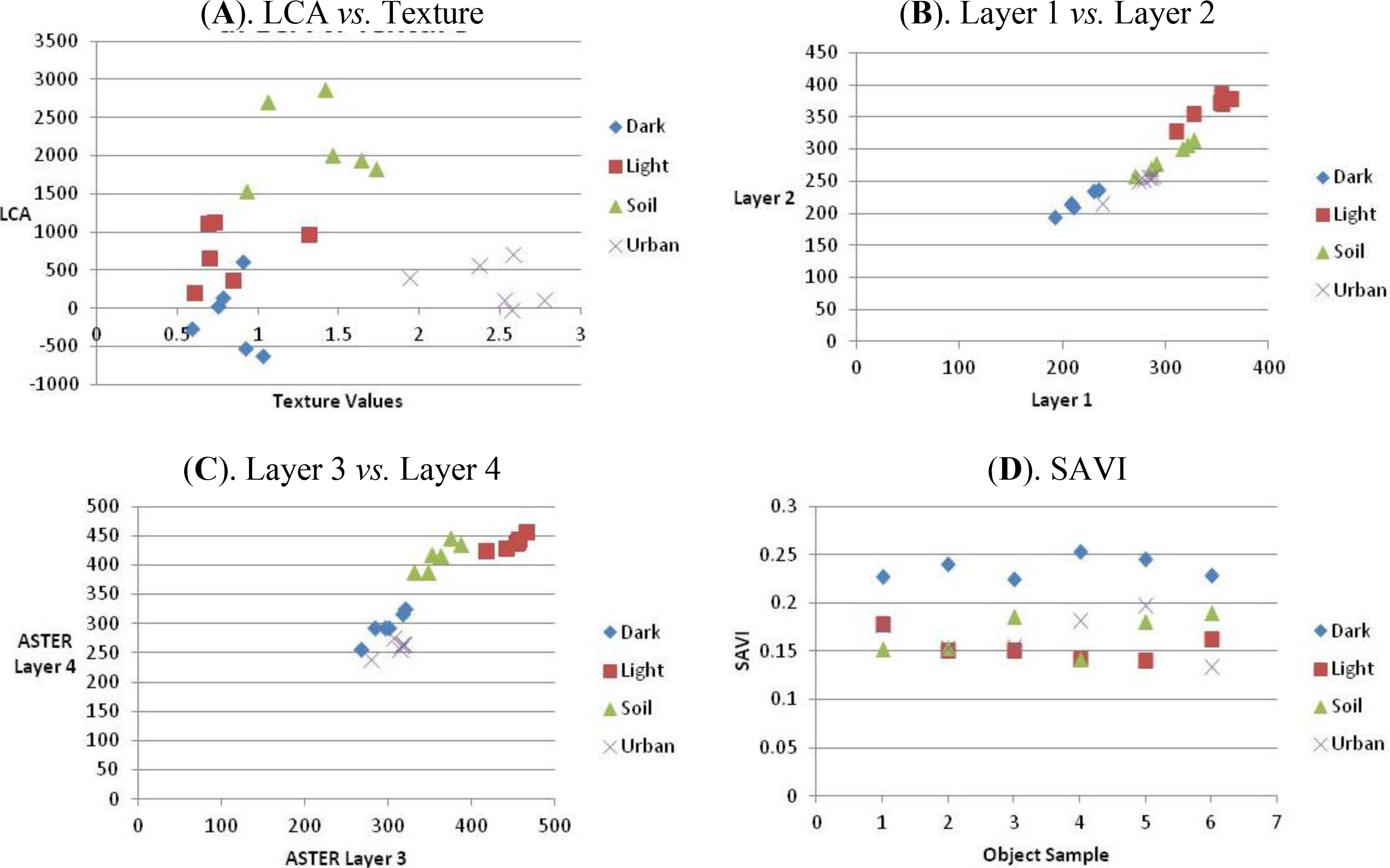
The classification of fallow or dormant agricultural plots (“inactive agriculture”) was difficult because these were spectrally similar qualities to other land uses. The accuracy assessment of the inactive agricultural plots is different between the OBIA method and the supervised and unsupervised classification (93% producers and 84% users for OBIA, 22% producer’s and 86% user’s for supervised, and 57% producers and 57% users for the unsupervised classification). The reason for such a disparity between these three methods is that the spectral properties of inactive agricultural plots are similar to “open desert” and “undeveloped urban.” The “open desert” class overlapped with “inactive agriculture” in the unsupervised and supervised classifications. The LCA index helped to distinguish fallow agriculture from open desert, as well as the discriminant analysis, but the OBIA also had the advantage of creating distinct objects—using the merging and growing object functions—which helped delineate large “open desert” and “inactive agriculture” plots.
The classification of “developed urban” varied widely between the OBIA and unsupervised classification method. The unsupervised classification had a producers’ accuracy of 75% and a users’ accuracy of 43%, whereas the OBIA accuracy for “developed urban” was 86% for the producer’s accuracy and had a users’ accuracy of 100%. The OBIA classification utilized several properties to distinguish the urban areas from other classes, including a PCA band (PCA 1), LCA, and texture, which both LCA and texture had excellent discrimination from other spectrally similar classes (
Figure 4).
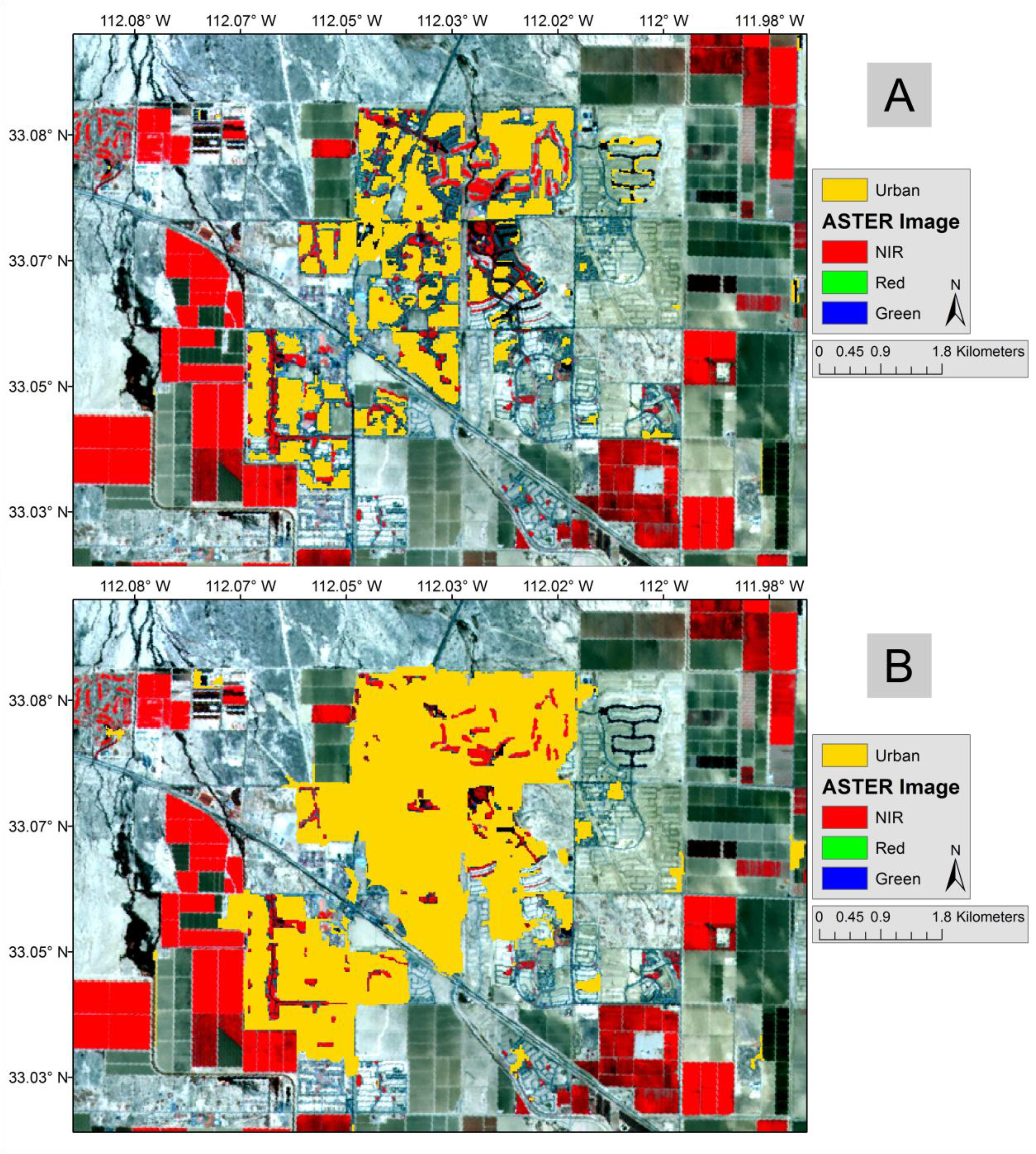
The “undeveloped urban” classification varied in results between the OBIA and unsupervised classification methods. The OBIA method had a 100% producer’s accuracy and 79% user’s accuracy, whereas the unsupervised classification had an 85% producer’s and 34% user’s accuracy. While the OBIA method more accurately classified “undeveloped urban,” there were still problems separating it from “open desert,” “inactive agriculture.” The spectral similarities between these three classes are the result of similar land covers (bare soil/sediment). The discriminant analysis helped classify the undeveloped areas, but only after the undeveloped areas were already classified using the “light/unused agriculture” intermediary class. It took several instances of classifying, reclassifying, and merging objects with intermediary classes to finally articulate the “undeveloped urban” land-use class in the final classification. However, as the user’s accuracy shows, there were several areas that were clearly “undeveloped urban” but were still misclassified as “open desert” or “inactive agriculture.” One observation noted in this study that has also been noted by others [
7,
24] is that land-use maps are capable of being produced from within the image data; however, confusion often occurs among land-use classes when similar land cover types are common between the classes. To reduce the impact of this problem, multiple steps of experimentation and refinement were performed during the development of the decision rules.
The diversity assessment indicates the amount of heterogeneity of the classified image (
Table 5). On a per-window basis, the OBIA classified fewer land use classes in any given 7 × 7 window
vs. the unsupervised or supervised classification. This confirmed our initial hypothesis (Section 2.6) and agrees with other studies comparing per-pixel classification methods with OBIA approaches [
36,
40]. This does not allude to the overall accuracy of the image; rather, it should be used to measure the amount of effort required for post-classification modification. The OBIA method has a higher concentration of windows with one land-use class, denoting a certain level of contiguity in the classification (
Figure 11). For OBIA, there is a lower frequency of windows as the number of land-use classes increases, following an exponentially decaying trend. The supervised and unsupervised classifications decay more linearly, which is indicative of these classifications being based solely on the spectral qualities of a single pixel. We believe this is the result of the segmentation and grouping of pixels into objects. The segmentation process uses spatial relationships in a way that is not possible with per-pixel approaches [
13], which is something that can be easily overlooked [
36].
The information gained from the diversity assessment highlights potential misclassifications, and serves as a guide for modifications to the classified map, similar to decision support systems used in other studies [
7]. Windows of pixels with one, two, or even three classes may be common, but a high number of classes per window can signal misclassified pixels. In a follow up to the diversity assessment, the land-use map was manually modified using the diversity assessment as a guide. The overall accuracy of the image was increased to 93.71% and the Kappa increased to 0.9223. The diversity assessment improved the classification by focusing on areas of greater heterogeneity.
4. Conclusions
A step-by-step procedure was given to map land-use in a mixed urban/agricultural area with ASTER imagery and object-based image analysis (OBIA). We demonstrated that it was possible to use a single multi-resolution segmentation of an ASTER image with a scale parameter of 10 to form meaningful objects. Two algorithms, grow region and merge region, transformed primitive objects into objects of interest. We classified active agriculture by merging all objects with a soil-adjusted vegetation index (SAVI) higher than 0.7, and then grew the region around it with slightly lower SAVI values. Similar methods were used to classify inactive agriculture (or fallow fields) and urban areas. Once the objects were formed, spatial information, such as area and relative distance, were used to classify the objects. Our research reinforces that object geometry and spatial relationships are effective when spectral properties alone are not sufficient to differentiate classes.
The Lignin-Cellulose Absorption index proved to be helpful both for classifying fallow fields and uncovering differences between fallow agricultural fields and open desert. Negative or weakly positive LCA values were associated with inactive agricultural fields, while deserts were associated with higher positive values. Land-use classifications that need to differentiate between open desert areas and inactive agricultural plots should consider the LCA (or a similar index) to help differentiate these two classes. An alternative is to use multi-temporal imagery to solve the confusion between fallow (inactive) agriculture and open desert, and this will be pursued in future research.
We also demonstrated that a land-use diversity assessment can assist the improvement of the final classification. The diversity assessment flags areas of high land-use heterogeneity, and we used these high diversity areas as a way to improve the final land-use map. This technique can be used to identify areas that need improvement, either for post-classification modifications or to refine the decisions rules. We also found that the OBIA method generates fewer regions of high land-use heterogeneity, which corroborates other research.
Finally, much of the focus of OBIA research centers on high resolution imagery, and OBIA seems to be used overwhelmingly to map land cover. Based on the outcome of this study, classifications using imagery from moderate resolution sensors (like ASTER) can also benefit from OBIA—and it need not be used solely for land-cover mapping. Meaningful land-use maps are possible, too, because while the land-use classes may be scale dependent, the methods are not.


