1. Introduction
The Zagros Orogenic Belt of Iran is one of the most prolific petroliferous areas, approximating 12% of the proven global oil reserves. It is well documented that a major portion of the oil reserve in the Zagrous Orgenic Belt is contained within the reservoirs of the Asmari (Oligo-Miocene) and Bangestan Group (Upper Cretaceous) anticlinal structures [
1]. In the folded belt of the Zagros Mountains, a sequence of Precambrian to Pliocene shelf sediments is deposited with a thickness of 12 km. This has undergone folding from the Miocene to more recent times [
2]. Most of these sections (6,000–7,000 m), which form the Cambrian to Miocene rocks, represent a single structural lithological unit popularly known as the Competent group [
2]. It is bounded by the detachment zones (above) and evaporite deposits (below).
The main types of salt structures in the Persian Gulf Basin are salt domes, salt pillows, salt walls, salt piercements, rim anticlines, turtleback structures, disharmonic folds, orogenic fold fillings and dissolution drapes [
3]. Diapiric oil fields, which accounts for 60% of the 600 billion barrels of total oil reserves of the Persian Gulf Basin, have grown continuously since Late Jurassic-Permian.
During the last decade, remote sensing and GIS techniques have been increasingly used for various applications in geosciences. More recently, the satellite data and GIS techniques have been used to detect and map the structural features [
4,
5,
6,
7,
8,
9] and also sub-surface deep seepages [
6].
This study emphasizes seismic potential mapping for the shallow oilfield in the Masjed-i-Soleiman area. Earthquakes are one of the natural hazards that cause damage to the structures, property and livestock. The most frequent occurring natural phenomena related to earthquakes are faulting, landslides, liquefaction and tsunamis. One of the most important damages caused by earthquakes occurs predominantly in shallow oilfields, and is mainly due to the faulting in ductile shallow cap rocks. It subsequently causes leakage of natural gas (through the uppermost hydrocarbon layer at the top of reservoir) from the oilfields. The sudden release of large-scale natural gas causes environmental pollution and firing of the adjacent area, leading to potential loss of life and property, or both.
The Masjed-i-Soleiman city is situated over the shallow buried MIS oilfield (the first explored oilfield in the Middle East) [
10]. From field observations, it was evident that the cap rock of this oilfield was fractured causing gas and oil leakages mostly in the residential areas. The population density surrounding these leakage areas is quite high. The continuous oil production from this oilfield over the last decades (
i.e., from 1908 to date) has caused the formation of a thick gas cap, predominantly H
2S, in the uppermost part of this hydrocarbon reservoir. Consequently, many oil seepages have changed to gas leakages [
11]. Fault activities have caused the large scale fracturing of the cap rock in the oil reservoir. Therefore, a sudden large-scale release of natural gas is predictable in the MIS.
In this research, with the aid of remote sensing techniques and image interpretation tools, the main fault zones were recognized. Further, the seismic potential of these fault zones were determined. Finally, the relationships of these structures, with respect to the localizing of gas leakage, have been studied in the GIS environment.
2. Study Area and Geological Setting
The Zagros fold-thrust belt was formed during several episodes of shortening, due to closure of the Tethys Ocean, and subsequent collision of the Arabian and Eurasian plates in the Late Cretaceous to Recent age [
12]. This seismically active fold-thrust belt can be divided into Thrust zone (High Zagros), simply folded belt and Coastal plain [
13,
14,
15,
16,
17,
18,
19]. The simply folded belt is divided into Fars Arc, Izeh zone and Dezful embayment by the Kazerun and Izeh fault zones. Dezful embayment appears to be a discrete structural unit, with boundaries defined by the Mountain front thrust fault to the northwest, the Kazerun-Borazjan and Izeh transverse faults to the east and southeast and the Zagros Fore deep (Frontal) fault to the southwest [
20,
21].
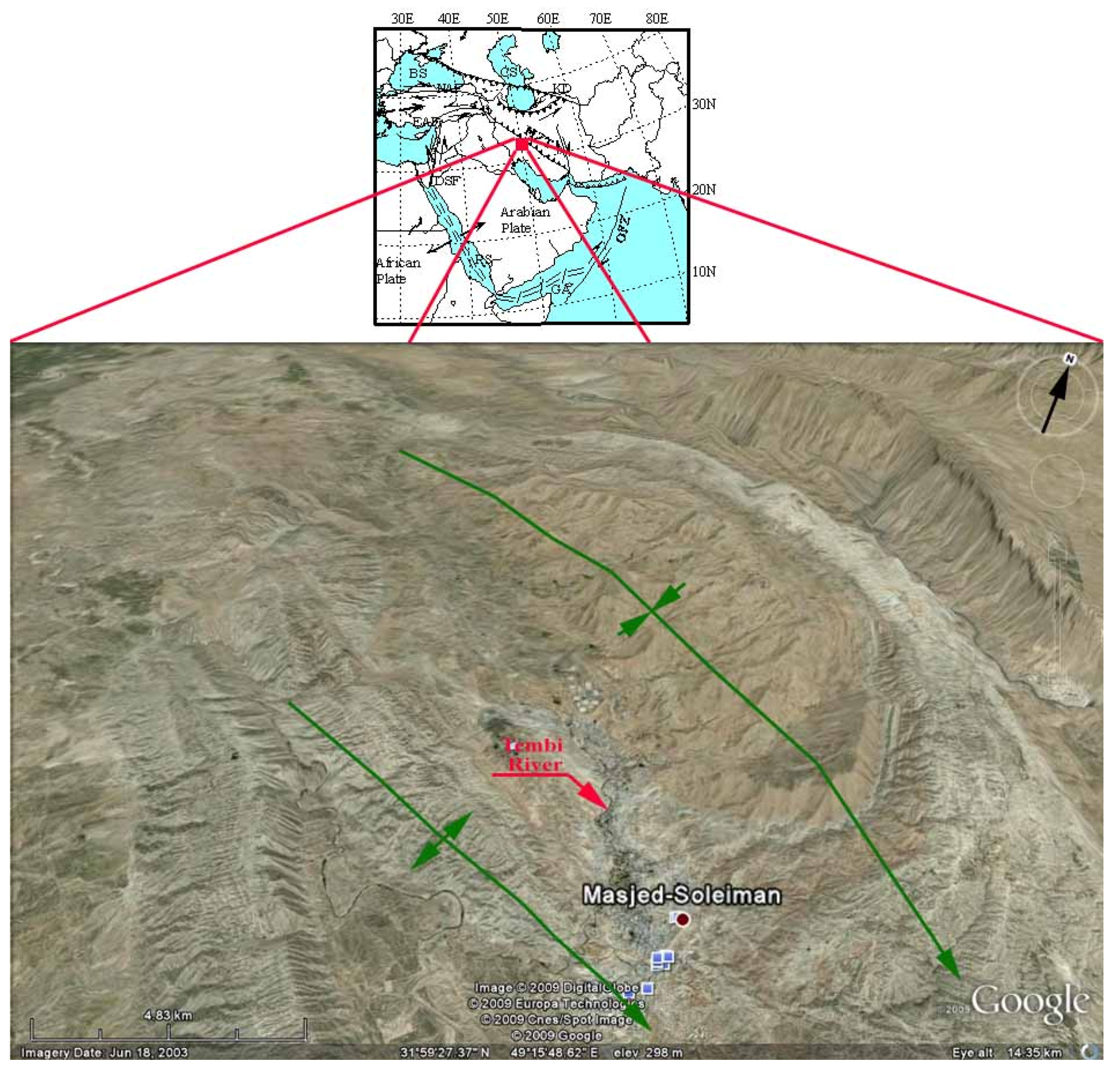
The MIS area lies within the coordinates: 31°42′37″N to 32°03′46″N and 49°02′31″E to 49°25′44″E and is located in the northern part of the Dezful embayment (
Figure 1). Topographically, MIS area is located in the piedmont zone of the Zagros Mountains (averaging 360 m). The main part of the study area is situated in and around the Tembi river valley and adjacent regions (
Figure 1).
Figure 1.
Geographical location of Masjed-i-Soleiman area (Google earth 2009 with modifications).
Figure 1.
Geographical location of Masjed-i-Soleiman area (Google earth 2009 with modifications).
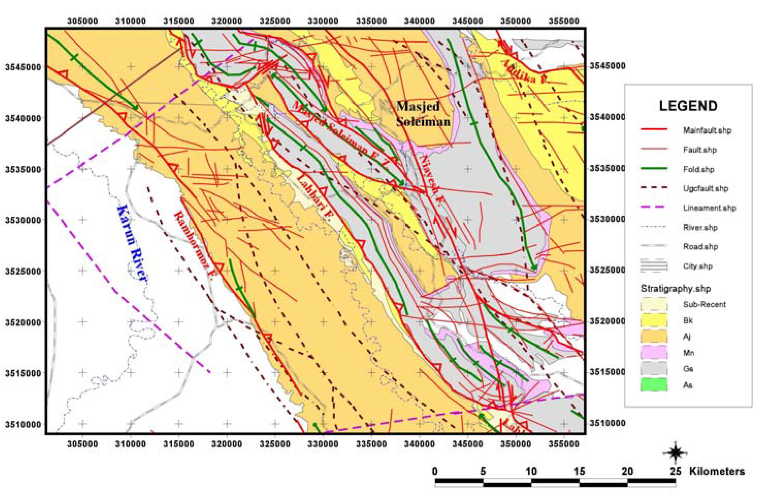
One of the most important features of this embayment is the buried shallow depth Asmari brittle formation (in Oligo-Miocece age, as hydrocarbon reservoir) under the ductile Gachsaran Formation (in Miocene age, as cap rock of oilfield). This hydrocarbon reservoir is situated in shallow depth (lesser than 300 m in depth) (NIOC 1988) and, therefore, a shallow oilfield has been formed in this area. The outcropped stratigraphic units (
Figure 2) comprise of Gachsaran, Mishan, Aghajari (with lahbari member) and Bakhtiari Formations. The main stratigraphic characteristics of Gachsaran and non-outcropped Asmari Formations are described in the following section.
2.1. Asmari Formation
This formation is of Oligo-Miocene age, and comprises approximately 460 m competent cream limestone with inter-bedded argillaceous limestone [
21]. The type section of this formation was measured in the Asmari anticline, which is located in the east of the study area. This formation shows mechanical brittle behavior and is predominantly fractured by existent fault zones. It has good porosity and permeability for forming a hydrocarbon reservoir.
2.2. Gachsaran Formation
This formation dates from the Miocene age and comprises a sequence of anhydrite and marl with marly limestone and salt inter-beds (approximately 1,500 m thickness) [
21]. Gachsaran formation shows a mechanical ductile behavior and is insignificantly fractured. Hence, it plays an important role as cap rock in the MIS oilfield.
Figure 2.
Geological map of the Masjed-i-Soleiman area.
Figure 2.
Geological map of the Masjed-i-Soleiman area.
3. Methodology
The following methodology has been adopted in this research for seismic hazard mapping for the shallow oil fields and its impact on the settlement. The following steps have been attempted in this research: (a) image processing and field investigations for distinguishing outcropped lithology and extracting structural features such as. faults and lineaments, (b) investigation of Recent Fault activities by seismotectonics assessment, (c) digitizing of underground contour map (UGC) and then, preparation of 3D-Sketch showing the relationship between the subsurface and surface structures.
3.1. Structural Geology
In this research, the spatial investigations consist of the interpretation of satellite image, field surveys and measurement of fault characteristics for the creation of the structural map.
Satellite Landsat 7 ETM+ image (NASA 2000) was geometrically corrected using 100 ground control points. The digital image processing techniques, such as filtering techniques using convolution kernel size, have been applied to extract the lineaments features from the image [
4]. The key elements for the image interpretation are tone, shape, topography, erosion, vegetation and linearity. False color composite (FCC) 741 (RGB) band composition image was developed using the ENVI software [
22]. In order to extract the linear structures, directional-filters were also applied. The extracted lineaments were checked and measured during the field investigations and then the final structural map was produced (
Plate 1).
Plate 1.
Structural map (with satellite image base) of the Masjed-i-Soleiman area.
Plate 1.
Structural map (with satellite image base) of the Masjed-i-Soleiman area.
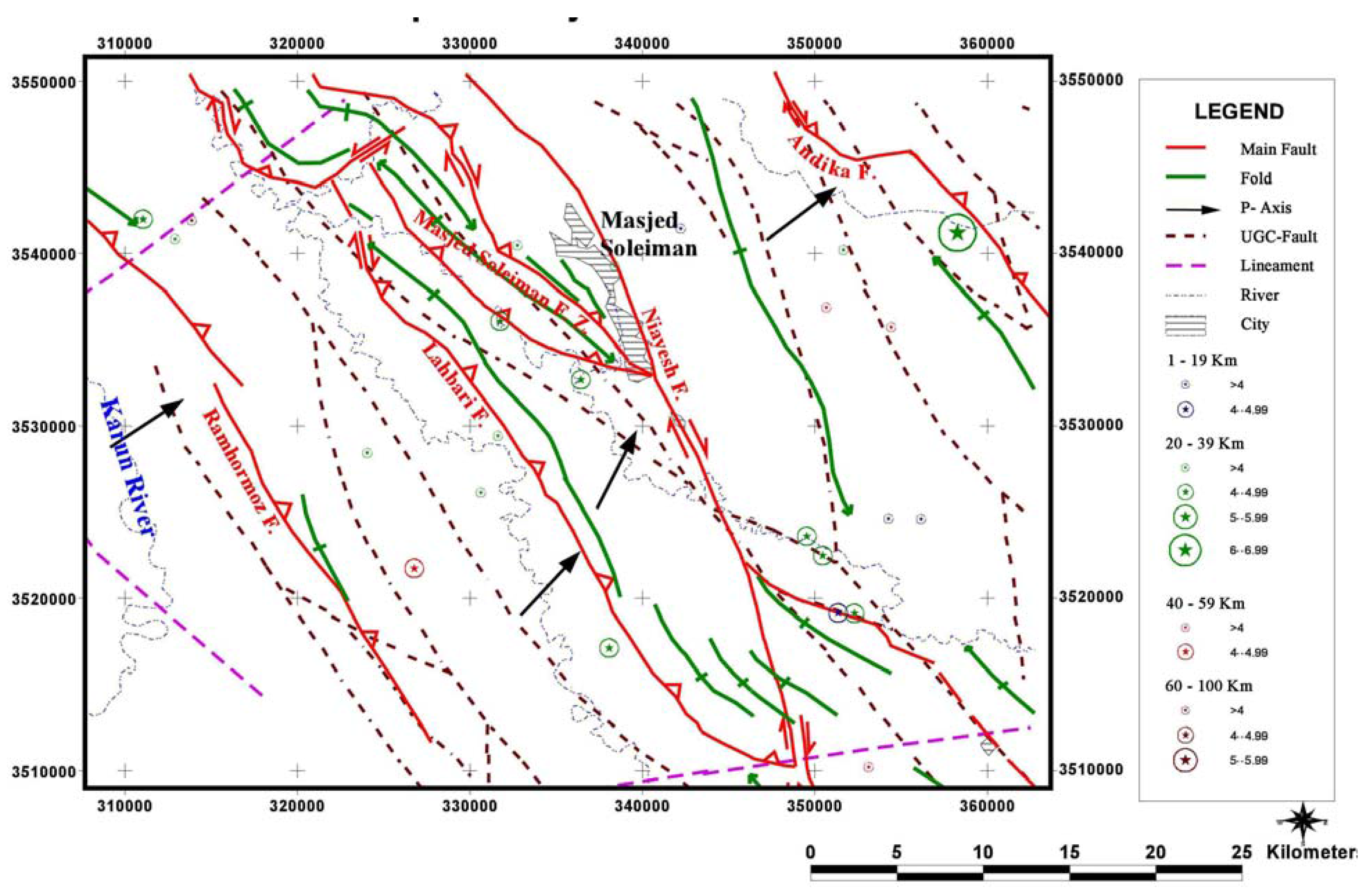
3.2. Seismotectonics
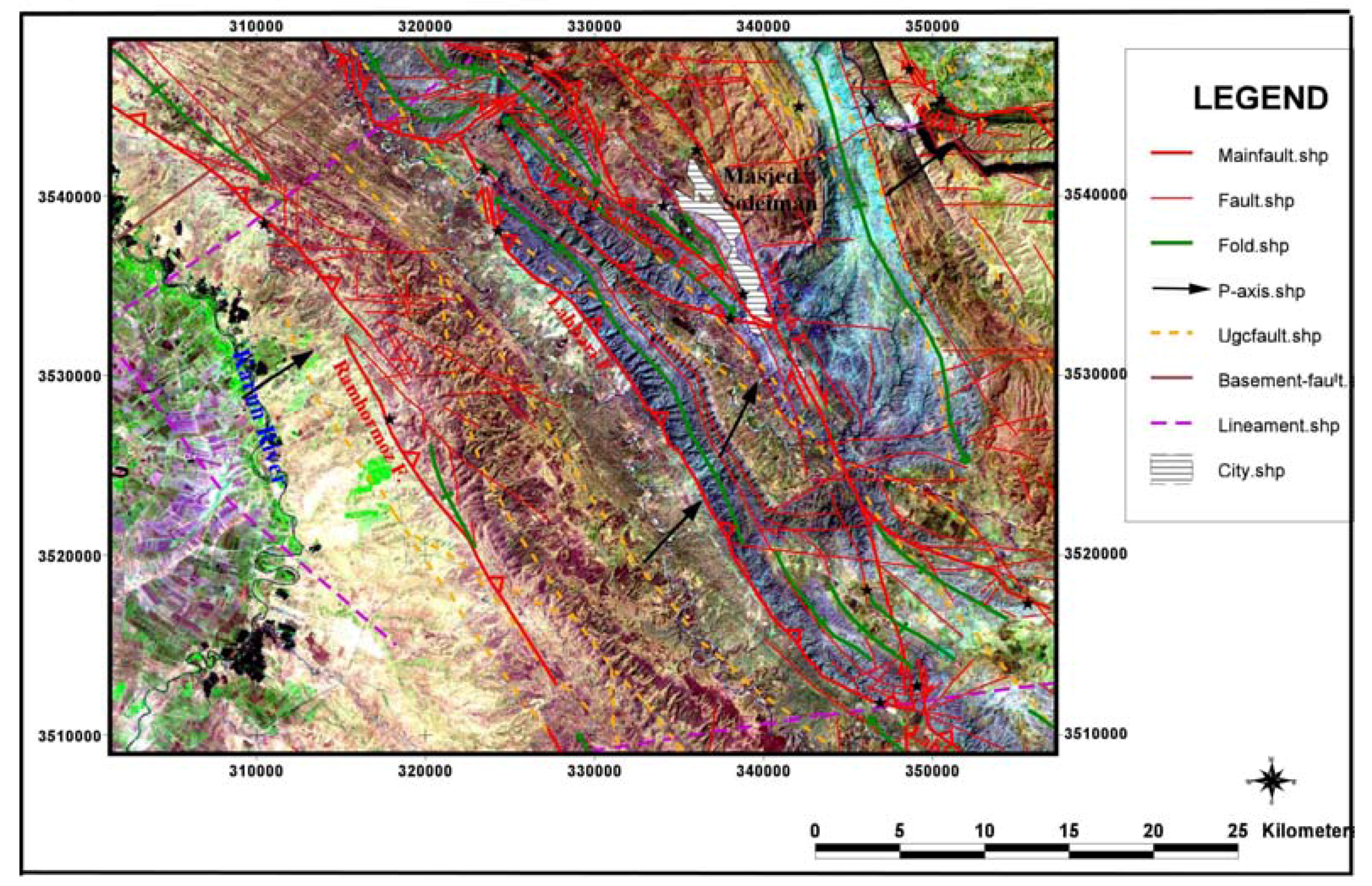
In this research, the emphasis was given to the seismotectonic analysis in order to find out the Quaternary (and recent) fault activities; and investigation of earthquakes. On the basis of seismotectonic studies, four main quaternary Masjed-i-Soleiman, Niayesh, Lahbari and Andika fault zones have been detected (
Figure 3), which have the potential for seismic activities. The activity impression, related earthquake epicenters and seismic potential of these fault zones, were also studied.
Figure 3.
Seismotectonic map of the Masjed-i-Soleiman area.
Figure 3.
Seismotectonic map of the Masjed-i-Soleiman area.
The seismic parameters of these faults such as magnitudes and horizontal ground accelerations were evaluated. The evaluations of these parameters were done using the deterministic (analytical) method. In this method, the maximum magnitude of probable earthquake is evaluated. In this research, the Nowroozi, Ambraseys and Melville modeling techniques were used for Iran’s earthquakes [
23,
24]. The equations of these models are given below:
After evaluating the maximum analytical magnitude, the Donovan and McGuire attenuation equations have been used to evaluate the maximum horizontal ground acceleration [
14]. These equations are as follows:
where R is the distance in Km, a is the maximum horizontal acceleration (Cm/s2), and e is Neperian base logarithm.
3.3. Underground Investigations
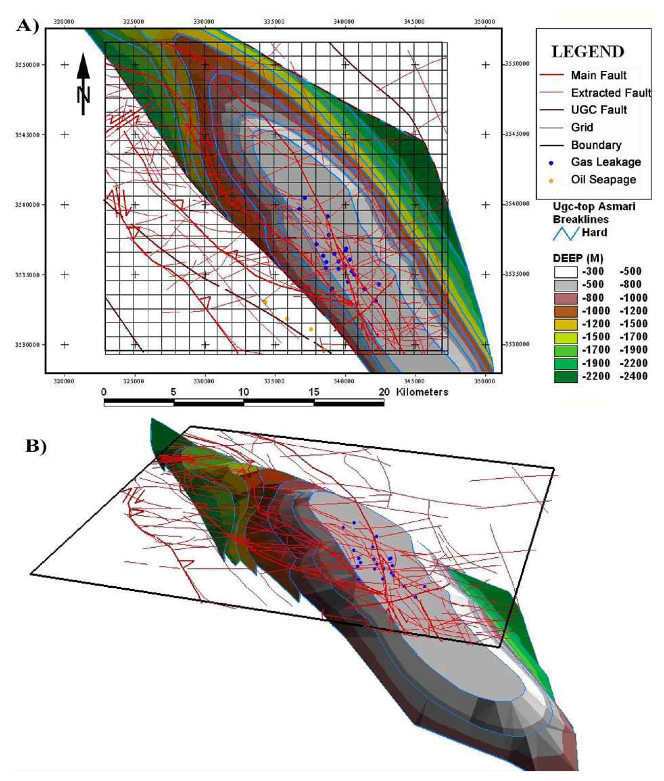
In order to make underground investigations, the underground contour map (UGC) of the top of the Asmari Formation has been digitized [
10]. Further, the Iso-potential surface of this UGC was reconstructed. The surface structures (fold axis and main fault zones) and the location of gas leakages (and oil seepages) were overlaid on this Iso-potential surface map (
Figure 4a). Using the GIS techniques, a 3D underground schematic sketch was prepared using Arcview 3.2 [
25]. This 3D map helped us to visually detect the relationship between the surface structures (such as faults and folds) and the subsurface structures (such as structural contours and UGC-faults which are shown on UGC-map). Moreover, the locational features of these gas leakages are exhibited on the generated 3D-sketch.
Figure 4b shows the rotation of this schematic 3D-sketch, the new viewpoints (aspects) and the surface and subsurface structural relationships between MIS anticline, main fault zones and gas leakage locations (
Figure 4b).
Figure 4.
Showing the 3D model of structures-gas leakages relationship (a) Preparation of Iso-potential surface of UGC map and overlaying surface structures [
10] (b) Construction of 3D-sketch from iso-potential surface and its rotation.
Figure 4.
Showing the 3D model of structures-gas leakages relationship (a) Preparation of Iso-potential surface of UGC map and overlaying surface structures [
10] (b) Construction of 3D-sketch from iso-potential surface and its rotation.
4. Results
This research paper discusses the oilfield and gas leakages that have occurred during the last decades due to the tectonics and seismic activities. The seismotectonics (or major fault) activities generated numerous lineaments and fractures, which play a major role in transmission of crude oils and H2S gas from the uppermost crust of the reservoir. Remote sensing techniques have proven to be a powerful tool for detecting lineaments, faults, folds and other structural features. The linearity of the vegetation and rugged topography of the studied area helped us to interpret structural features from the images. This study shows that the directional filtering and liner 2% enhancement techniques increased the interpretation ability for the analyst. The field observation coupled with remote sensing and GIS techniques were very helpful for the interpretation of the lineaments and faults at the surface and near the surface.
4.1. Structural Geology
Four main fault zones were detected in the studied area namely, Masjed-i-Soleiman, Niayesh, Lahbari and Andika. The main characteristics of these fault zones have been studied.
4.1.1. Masjed-i-Soleiman Fault Zone
This fault zone is 22 km in length, and extends from the northwest to southeast of the MIS area. It comprises of several reverse faults showing N115-125/65-NE trends, forming a structural Duplex (
Plate 2a) [
26]. The kinematical mechanism of this fault zone is reverse faulting with minor dextral strike slip component. The activities of this fault zone created the Masjed-i-Soleiman anticline as a fault related fold (
Figure 5).
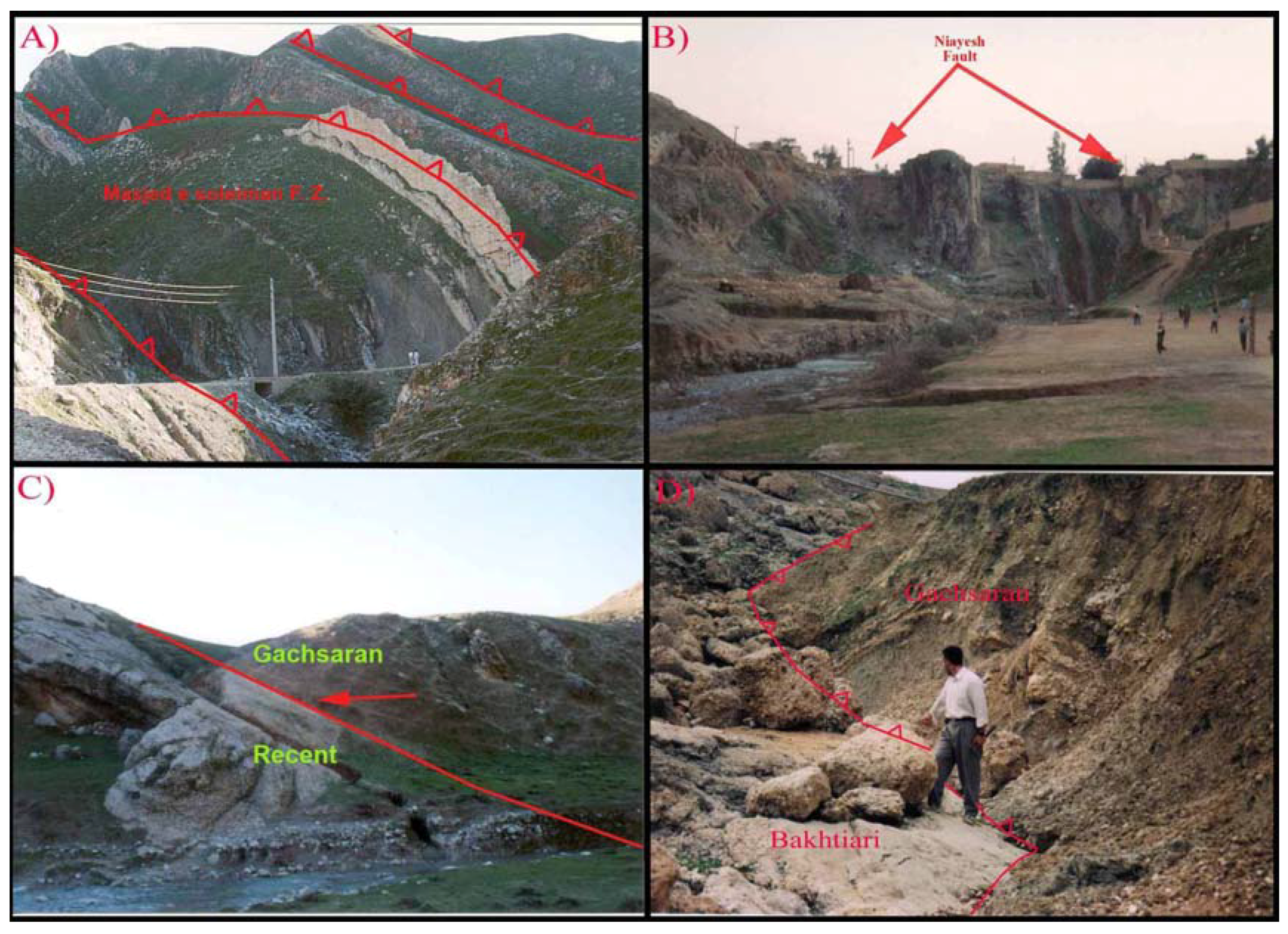
Plate 2.
Field evidence of main fault zones in Masjed-i-Soleiman area (a) MIS fault zone as a duplex; (b) Niayesh fault in residential area of MIS city (c) Lahbari thrust fault zone; (d) Andika fault zone.
Plate 2.
Field evidence of main fault zones in Masjed-i-Soleiman area (a) MIS fault zone as a duplex; (b) Niayesh fault in residential area of MIS city (c) Lahbari thrust fault zone; (d) Andika fault zone.
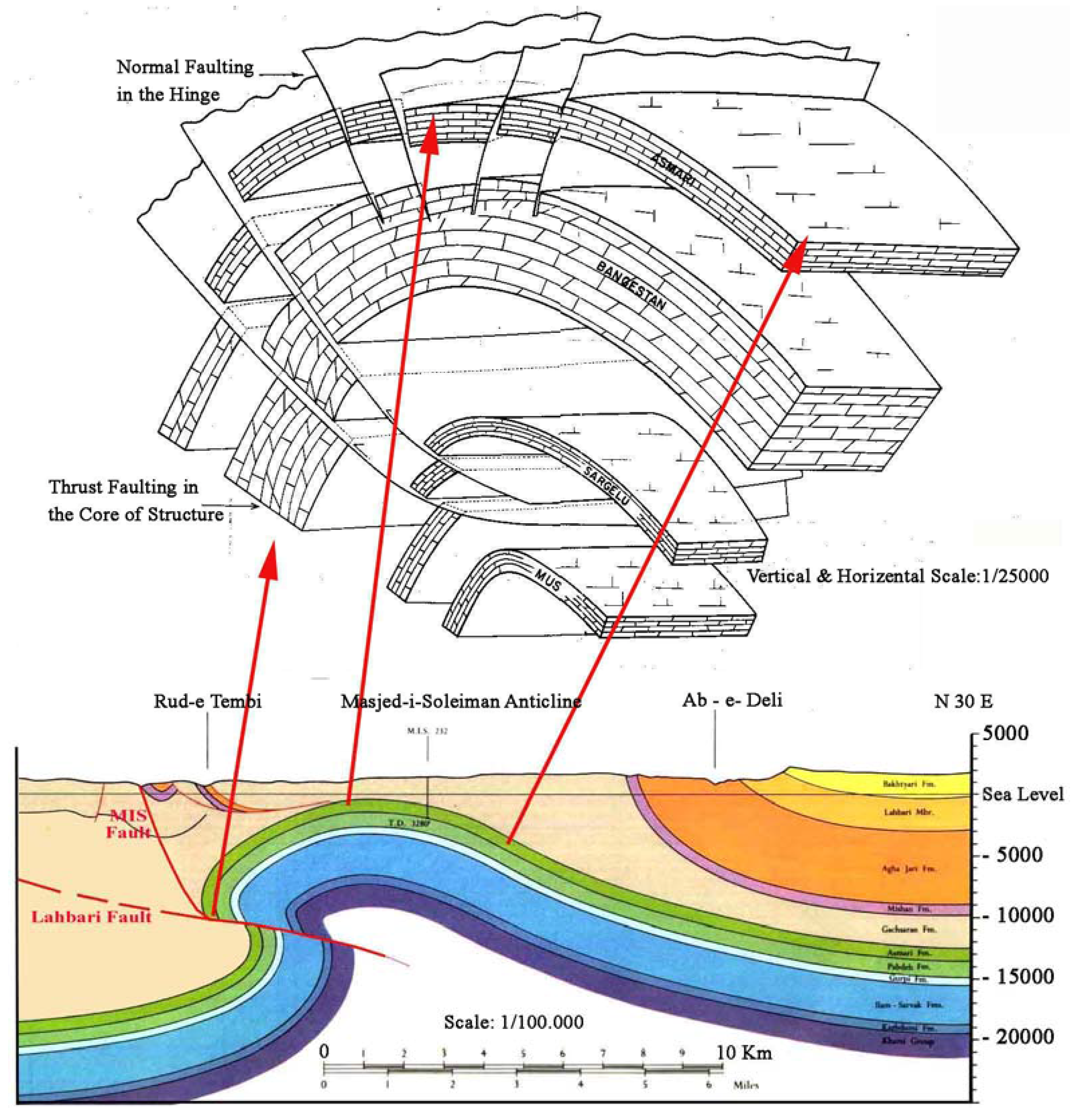
Figure 5.
Formation of Masjed-i-Soleiman anticline due to activity of MIS fault zone (Modified from Keyhanfar 1995 and NIOC 1967) [
10,
27].
Figure 5.
Formation of Masjed-i-Soleiman anticline due to activity of MIS fault zone (Modified from Keyhanfar 1995 and NIOC 1967) [
10,
27].
4.1.2. Niayesh Fault Zone
This dextral strike slip fault zone is 72 km in length and extends from the north of the MIS to the southwest of Haftgel city. This transverse fault zone crosses the MIS residential area (
Plate 2b). The main structural attitude of the Niayesh fault is N160-170/75-NE. The kinematical mechanism of this fault zone is dextral strike slip. The major activities of this fault caused truncating and dextral dragging of MIS anticline.
4.1.3. Lahbari Fault Zone
This reverse fault zone is 90 Km in length and extends from the Batvand area (located in the west-northwest of MIS region) to the northeast of Haftgel city (located 45 km south of MIS region). The main structural attitude of the Lahbari fault is N140/65-NE. The kinematical mechanism of this fault zone is reverse faulting with minor dextral strike slip component. The activities of this fault caused thrusting of Gachsaran Formation (in Miocene age) over Quaternary Bakhtiari conglomerates (
Plate 2c).
4.1.4. Andika Fault Zone
This fault zone is 45 km in length and is located approximately 14 km northeast of the MIS city (in northeast corner of study area) (
Plate 2d). The main structural attitude of this fault is N145/50-NE. The kinematical mechanism of this fault zone is dextral strike slip with minor reverse component (
Plate 2d). The activity of this fault caused dextral dragging of other structures (such as faults and anticlines).
4.2. Seismotectonics
Siesmotectonically, Quaternary fault activities and its possible earthquake investigation during the last decades have shown that the entire aforementioned fault zone plays a major role in the generation of seepages (and leakages) in the study area. The description is given as follows:
4.2.1. Masjed-i-Soleiman Fault Zone
The field activity of this fault zone revealed that the Quaternary activity played a major role in thrusting the Gachsaran Formation over the Tembi Quaternary plain (
Plate 1). The recent activity has also tilted and caused truncating of recent alluvium along the old MIS road. The earthquake epicenters that are related to the recent activities of this fault have been depicted in
Table 1. On the basis of analytical evaluation of seismic parameters (
Table 2), we can say that this fault can generate future earthquakes with maximum magnitude of Ms = 6.23 and maximum horizontal ground acceleration 0.37 g in MIS city.
Table 1.
The correlation of main quaternary fault zones and earthquakes. Ms = maximum magnitude on the Richter scale.
Table 1.
The correlation of main quaternary fault zones and earthquakes. Ms = maximum magnitude on the Richter scale.
| Date | Caused Fault | Long. | Lat. | Depth | Ms |
| 1964/01/12 | Niayesh | 49.4 | 31.5 | 67 | 5.2 |
| 1989/03/01 | Niayesh | 49.46 | 31.58 | 46 | 4.5 |
| 1994/10/27 | Niayesh | 49.41 | 31.43 | 33 | 4.6 |
| 1995/04/18 | Niayesh | 49.43 | 31.8 | 18 | 4.9 |
| 2002/12/30 | Niayesh | 49.41 | 31.84 | 33 | 4.8 |
| 2002/12/30 | Niayesh | 49.41 | 31.84 | 33 | 4.8 |
| 2003/01/01 | Niayesh | 49.44 | 31.8 | 33 | 4.7 |
| 1995/06/07 | MIS | 49.23 | 31.99 | 33 | 4.3 |
| 2001/12/23 | MIS | 49.29 | 31.78 | 33 | 4.7 |
| 2001/12/23 | Lahbari | 49.24 | 31.67 | 33 | 4.5 |
| 2003/12/11 | Lahbari | 49.22 | 31.95 | 33 | 5 |
4.2.2. Lahbari Fault Zone
The activity of this fault caused a thrusting of Miocene evaporites over Quaternary conglomerates (
Plate 2c). The earthquake epicenters which are related to the recent activities of this fault are illustrated in
Table 1. This fault has the capacity to generate future earthquakes with a maximum magnitude Ms = 7.05 and maximum horizontal ground acceleration 0.32 g in MIS city.
Table 2.
Evaluation of seismic parameters of the main fault zones in Masjed-i-Soleiman area.
Table 2.
Evaluation of seismic parameters of the main fault zones in Masjed-i-Soleiman area.
| Evaluated Max. Acceleration | Evaluated Max. Magnitude | Distance From MIS
(Km) | Mechanism | Length
(Km) | Fault
Name |
Mean
(g) | McGuire (1973)
Cm/s2 | Donovan(1972)
Cm/s2 | Mean | Ambraseys
&Melville
(1982) | Nowroozi
(1985) |
| 0.37 | 386.5 | 347.2 | 6.23 | 6.18 | 6.28 | Crossing the city | Reverse | 22 | MIS |
| 0.55 | 593.4 | 485.3 | 6.92 | 6.92 | 6.92 | Crossing the city | Dextral
Strike slip | 72 | Niayesh |
| 0.32 | 354.4 | 281.3 | 7.05 | 7.06 | 7.04 | 15 | Reverse | 90 | Lahbari |
| 0.26 | 283.5 | 238.1 | 6.65 | 6.63 | 6.67 | 14 | Dextral
Strike slip | 45 | Andika |
4.2.3. Andika Fault
The field evidences of this fault zone indicate that the truncating and tilting of young Quaternary (to Sub-Recent) lithified sediments are exhibited in the Andika region. The main earthquake epicenter that is related to the recent activity of this fault zone was reported on 15 July 1929, an earthquake with Ms = 6.25. This fault has the capacity to generate future earthquake with a maximum magnitude Ms = 6.65 and maximum horizontal ground acceleration 0.26 g in MIS city.
5. Discussions
MIS city is located in the Dezful embayment zone of the Zagros fold-thrust belt. This seismically active fold-thrust belt has several anticlines representing medium to large scale oilfields. Due to the tectonic settings of the Dezful embayment, many of these oilfields are situated at a shallow depth. The MIS oilfield is situated at a shallow depth, close to historical places such as the Zoroastrian temple, which may be established due to the oil seepages and minor gas leakages.
In this research, four main fault zones namely, Niayesh, Lahbari, Andika and MIS fault zone are recognized in the studied area. These were detected from the satellite image based on image interpretation technique.
The structural studies and controlling of structural cross section revealed that the MIS anticline is formed due to the thrusting movement along the MIS fault zone; hence creating a propagation fold (
Figure 5). This reverse movement along fault zone formed the shallow buried anticline and, consequently, a shallow oilfield with 300 to 600 m depth (on the basis of UGC of top of Asmari formation) [
9].
The accumulation of hydrocarbons in the competent Asmari Formation of this anticline has created the MIS oilfield. The main reservoir of this oilfield consists of competent cream limestone of Asmari which is overlaid by evaporitic rocks of Gachsaran Formation (as cap rock). MIS city is a high populated residential area and is situated in the center of the shallow oilfield.
The Niayesh and MIS fault zone activities have affected the oilfield. Subsequently, a highly dense fracture zone has developed within the intersection of Niayesh and MIS fault zones. Therefore, the cap rocks are highly fractured in nature.
On the basis of the 3D model and geological interpretation, it can be seen that a high density fracture zone has formed within the intersection between the Niayesh and the MIS fault zones. This is organized over a hinge zone with dense tensile fractures of the MIS buried anticline (
Figure 5). The highly fractured reservoir and cap rocks caused several oil seepages and gas leakages from the MIS oilfield in the residential areas at a shallow depth. Moreover, the long-term oil production from this oilfield (from 1908 to present) has formed a thick gas cap (predominantly H2S) in the upper most part of the hydrocarbon reservoir in the studied area. Unfortunately, in recent years, many oil seepages have been causeddue to the leakages of gas.
The seismotectonic behavior of the region is studied and it shows that four main fault zones are active faults. These fault zones have evidences of Quaternary to Recent activities such as: Tilting, dragging and truncating of lithified Sub-Recent and Quaternary sediments showing that the thrusting of Gachsaran Formation has taken place over the Plio-Pleistocene Bakhtiari Formation. The activities of these fault zones caused the high rate regional seismicity in the Masjed-i-Soleiman residential areas. The strongest earthquake, which recently took place on 15 July 1929, has a recorded magnitude of Ms = 6.25 on the Richter scale (
i.e., in Andika area placed in 14 Km of NE of MIS city). The seismotectonic study revealed that re-activation of these active faults might have caused the large earthquakes with maximum magnitude 6.23 < Ms < 7.05 (on the Richter scale) and maximum horizontal acceleration 0.26 < a < 0.55 (g) (
Table 2). Furthermore, the re-activation of these fault zones in future may generate a large earthquake. This may develop the large scale fracturing of Gachsaran ductile cap rocks and thus, may release a large volume of H
2S gas from the upper most of the reservoir.
6. Conclusions
The activity of the MIS reverse fault zone has developed in the Dezful embayment zone within the Zagros fold-thrust belt. It has formed the MIS shallow buried anticline and acts as a fault related fold. The accumulation of hydrocarbon in the competent Asmari Formation (overlaid by ductile Gachsaran Formation) established the MIS shallow oilfield with a thick gas cap under MIS residential area. The intersection of the Niayesh and the MIS fault zones has created high fracture zones that have caused gas leakage (and oil seepage) through the thick gas cap of this oilfield.
The activities of main active fault zones could generate destructive earthquakes in future; with geological seismite such as large scale opening of previous fractures and or forming new fractures in the Gachsaran ductile cap rocks. The creation of large scale tensile fractures in the hinge zone of the shallow buried MIS anticline (with reservoir contain thick gas cap) is the main cause of release of large volumes of gas, predominantly H2S, from the upper most part of this oilfield, posing danger to the inhabitants and damaging the environment. This study concluded that the integration of remote sensing and GIS techniques in conjunction with field observation can be successfully utilized for mapping structural features and also environmental impacts in oilfield and seepages.


