Ten Years of SeaWinds on QuikSCAT for Snow Applications

Abstract
:1. Introduction
2. Data Characteristics


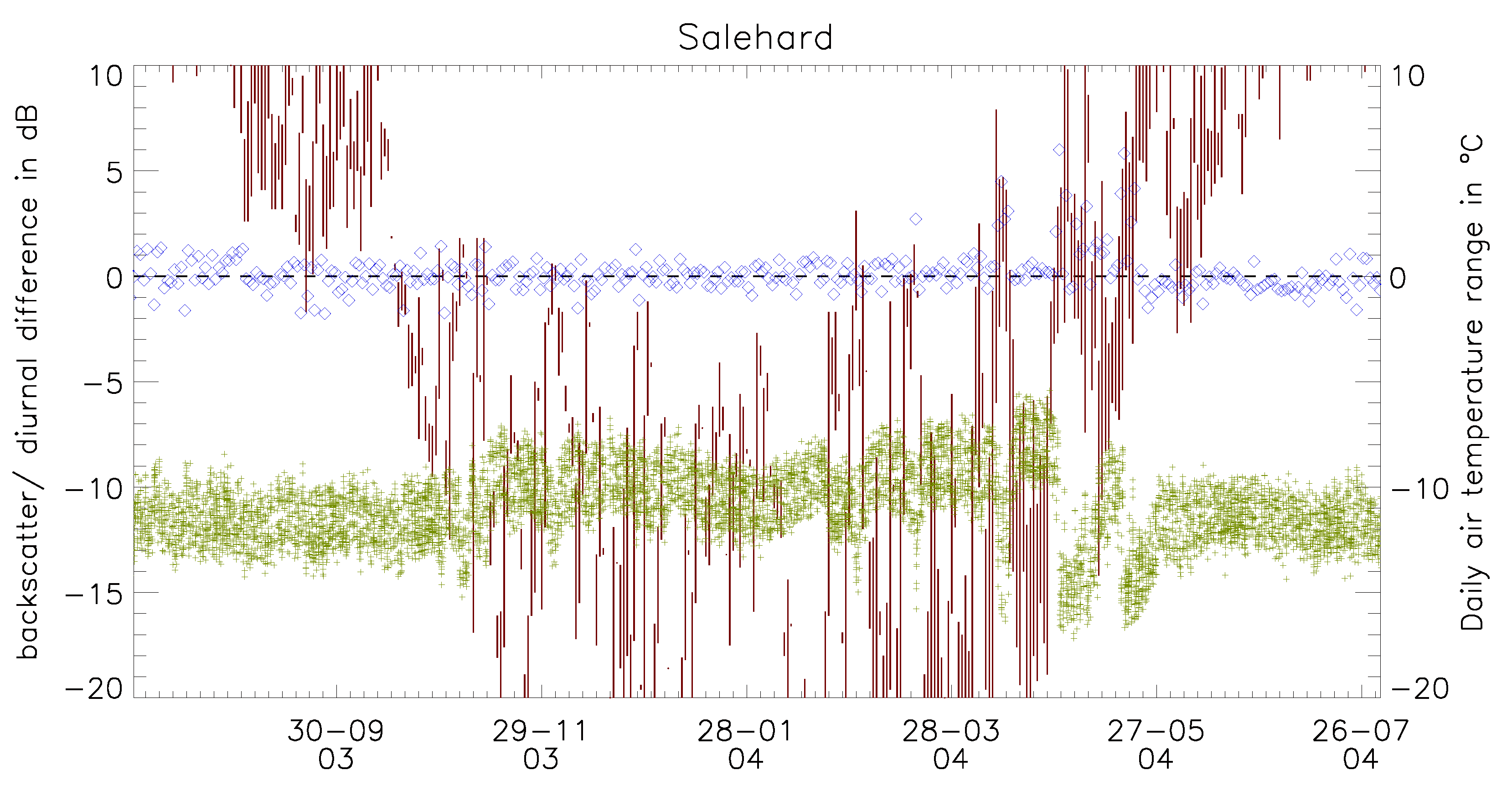
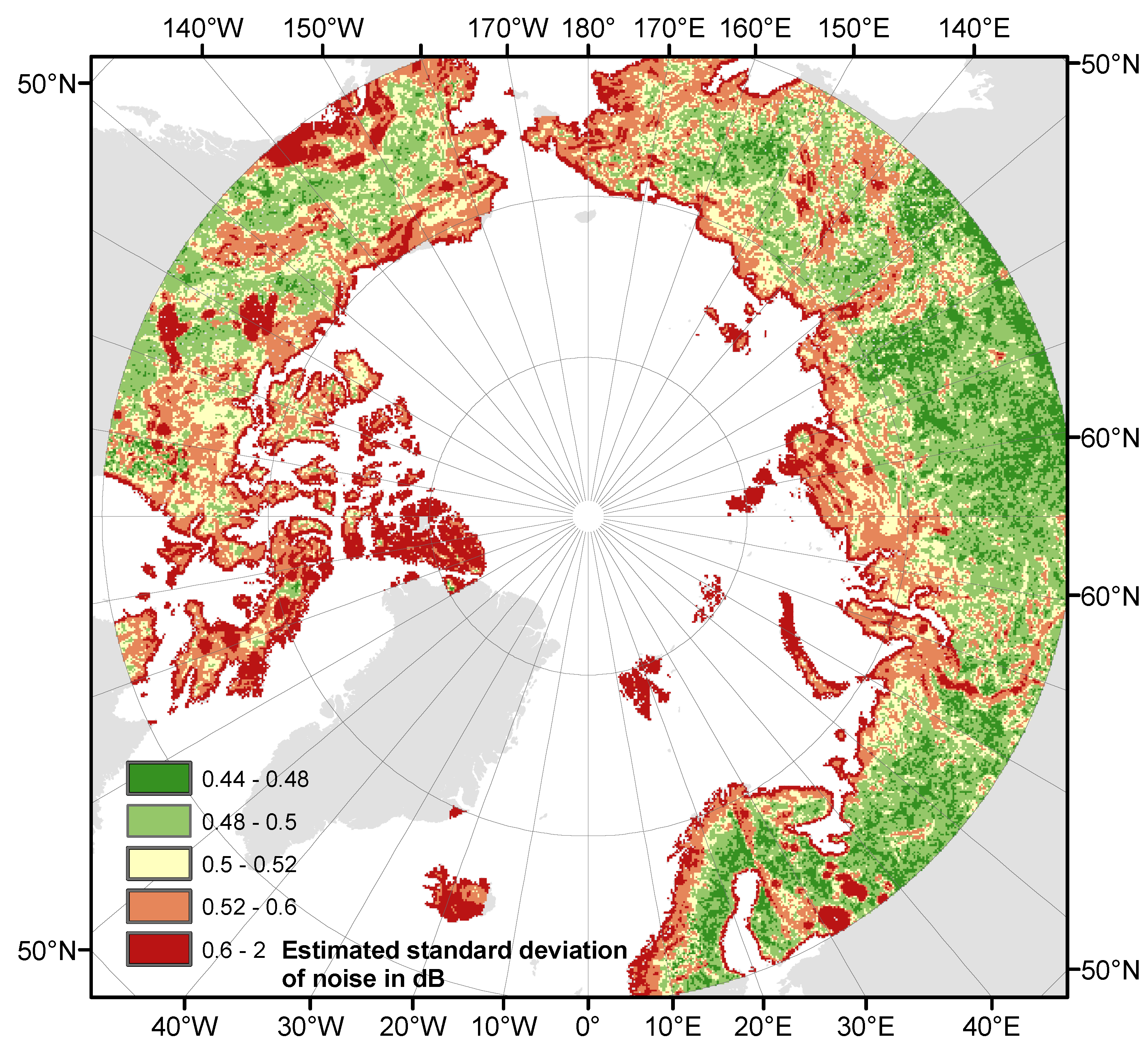
| GlobCover class | Min | Max | Mean |
|---|---|---|---|
| mixed broad leaved and needleaved forest | 0.45 | 0.97 | 0.50 |
| needle leave deciduous or evergreen forest | 0.45 | 1.17 | 0.49 |
| sparse vegetation (less than 15%) | 0.46 | 1.66 | 0.59 |
| water | 0.48 | 2.46 | 1.98 |
| permanent snow and ice | 0.48 | 2.20 | 0.87 |
3. Change Detection Approaches
| Reference | Sensor | Method | Parameters |
|---|---|---|---|
| [31] Boehnke & Wismann 1996 | ERS (C-band) | Location specific summer (July) and winter (February) backscatter | Thaw timing |
| [11] Frolking et al. 1999 | NSCAT | Five day average backscatter and location specific difference from overall mean | Thaw timing |
| [15] Kimball et al. 2001 | NSCAT | Application of similar method as in Boehnke et al. 1996 | Thaw timing |
| [18] Kidd et al. 2003, [12] Bartsch et al. 2007 | SeaWinds QuikSCAT | Diurnal differences with respect to noise and multiple thaw periods | Start and end of major thaw period |
| [16] Kimball et al. 2004a | NSCAT | Extension of Frolking et al. 1999 | Start, end, primary thaw date |
| [33] Kimball et al. 2004b | SeaWinds QuikSCAT | As in Kimball et al. 2004a | Start, end, primary thaw date plus autumn refreeze |
| [23] Brown et al. 2007 | SeaWinds QuikSCAT | Fixed threshold for deviation from winter (February) backscatter level | Thaw timing |
| [24] Wang et al. 2008 | SeaWinds QuikSCAT | Application of method from Frolking et al. 1999 to average evening backscatter with respect to summer mean values (August) | Snow-off date |
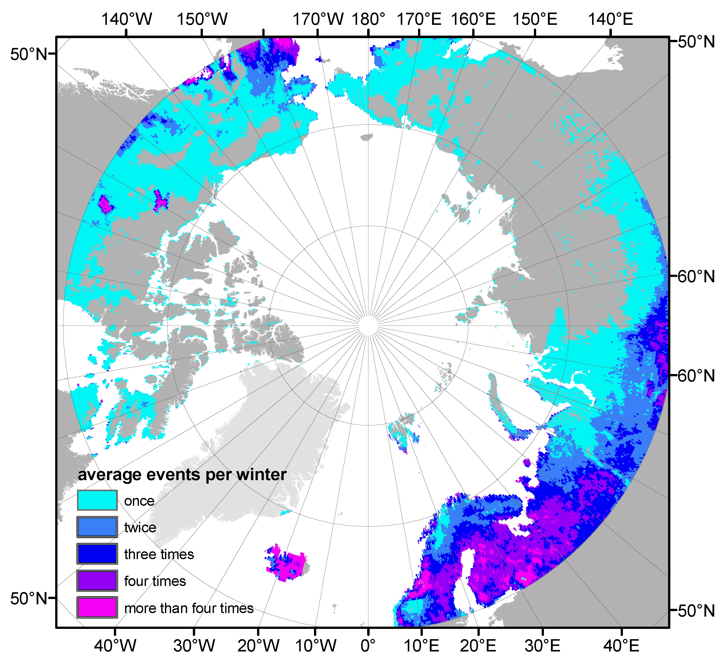
4. Applications
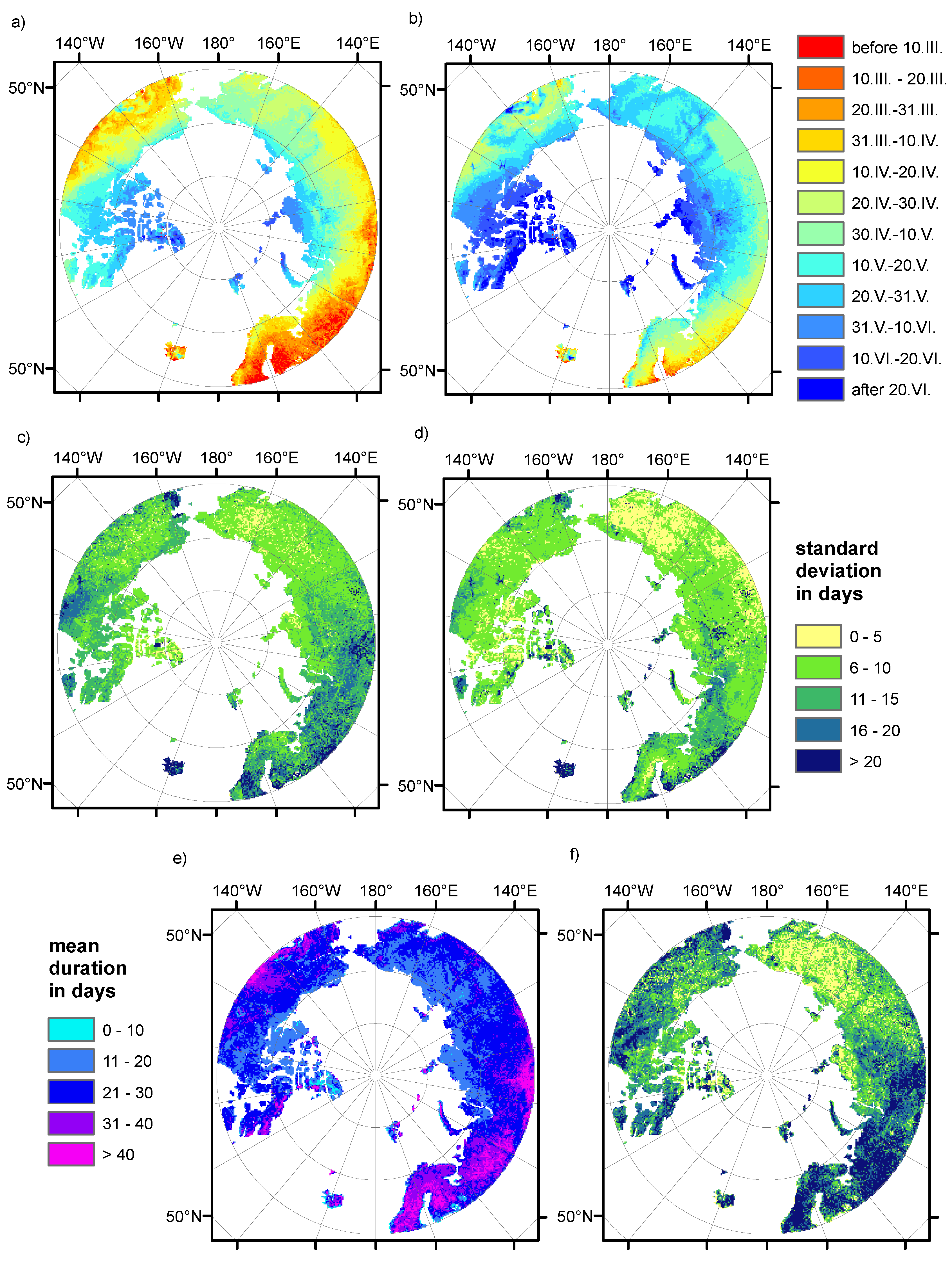
5. Summary
Acknowledgements
References
- Ulaby, F.T.; Stiles, W.H. The Active and Passive Microwave Response to Snow Parameters 2. Water Equivalent of Dry Snow. J. Geophys. Res. 1980, 85, 1045–1049. [Google Scholar] [CrossRef]
- Mätzler, C.; Schanda, E. Snow Mapping with Active Microwave Sensors. Int. J. Remote Sens. 1984, 5, 409–422. [Google Scholar] [CrossRef]
- Yang, D.; Zhao, Y.; Armstrong, R.; Robinson, D.; Brodzik, M.J. Streamflow Response to Seasonal Snow Cover Mass Changes over Large Siberian Watersheds. J. Geophys. Res. 2007, 112, F02S22. [Google Scholar] [CrossRef]
- Yang, D.; Ye, B.; Kane, D.L. Streamflow Changes over Siberian Yenisei River Basin. J. Hydrol. 2004, 296, 59–80. [Google Scholar] [CrossRef]
- Muskett, R.R.; Romanovsky, V.E. Groundwater Storage Changes in Arctic Permafrost Watersheds from GRACE and in situ Measurements. Env. Res. Lett. 2009, 4, 045009. [Google Scholar] [CrossRef]
- Shiklomanov, A.I.; Lammers, R.B. Record Russian River Discharge in 2007 and the Limits of Analyses. Env. Res. Lett. 2009, 4, 045015. [Google Scholar] [CrossRef]
- Nghiem, S.V.; Steffen, K.; Kwok, R.; Tsai, W.Y. Detection of Snow Melt Regions on the Greenland Ice Sheet Using Diurnal Backscatter Change. J. Glaciol. 2001, 47, 539–547. [Google Scholar] [CrossRef]
- Tedesco, M. Snowmelt Detection over the Greenland Ice Sheet from SSM/I Brightness Temperature Daily Variations. Geophys. Res. Lett. 2007, 34, L02504. [Google Scholar] [CrossRef]
- Nghiem, S.V.; Chao, Y.; Neumann, G.; Li, P.; Perovich, D.K.; Street, T.; Clemente-Colon, P. Depletion of Perennial Sea Ice in the East Arctic Ocean. Geophys. Res. Lett. 2006, 33, L17501. [Google Scholar] [CrossRef]
- Yu, P.; Clausi, D.A.; Howell, S.E.L. Fusing AMSR-E and QuikSCAT Imagery for Improved Sea Ice Recognition. IEEE Trans. Geosci. Remote Sens. 2009, 47, 1980–1989. [Google Scholar] [CrossRef]
- Frolking, S.; McDonald, K.C.; Kimball, J.S.; Way, J.B.; Zimmermann, R.; Running, S.W. Using the Space-Borne NASA Scatterometer (NSCAT) to Determine the Frozen and Thawed Seasons. J. Geophys. Res. 1999, 104, 27895–27907. [Google Scholar] [CrossRef]
- Bartsch, A.; Kidd, R.A.; Wagner, W.; Bartalis, Z. Temporal and Spatial Variability of the Beginning and End of Daily Spring Freeze/Thaw Cycles Derived from Scatterometer Data. Remote Sens. Environ. 2007, 106, 360–374. [Google Scholar] [CrossRef]
- Tsai, W.T.; Nghiem, S.V.; Huddleston, J.N.; Spencer, M.W.; Stiles, B.W.; West, R.D. Polarimetric Scatterometry: A Promising Technique for Improving Ocean Surface Wind Measurements from Space. IEEE Trans. Geosci. Remote Sens. 2000, 38, 1903–1921. [Google Scholar] [CrossRef]
- Callahan, P.S. QuikSCAT Science Data Product Users Manual, Overview and Geophysical Data Products; Version 3.0; JPL: Pasadena, CA, USA, 2006; D-18053-RevA. [Google Scholar]
- Kimball, J.S.; McDonald, K.C.; Keyser, A.R.; Frolking, S.; Running, S.W. Application of the NASA Scatterometer (NSCAT) for Determining the Daily Frozen and Nonfrozen Landscape of Alaska. Remote Sens. Environ. 2001, 75, 113–126. [Google Scholar] [CrossRef]
- Kimball, J.S.; McDonald, K.C.; Frolking, S.; Running, S.W. Radar Remote Sensing of the Spring Thaw Transition Across a Boreal Landscape. Remote Sens. Environ. 2004, 89, 163–175. [Google Scholar] [CrossRef]
- Nghiem, S.V.; Tsai, W.Y. Global Snow Cover Monitoring with Spaceborne Ku-Band Scatterometer. IEEE Trans. Geosci. Remote Sens. 2001, 39, 2118–2134. [Google Scholar] [CrossRef]
- Kidd, R.A.; Trommler, M.; Wagner, W. The Development of a Processing Environment for Time-Series Analyses of SeaWinds Scatterometer Data. In Proceedings of IEEE 2003 International Geoscience and Remote Sensing Symposium, Toulouse, France; 2003; pp. 4110–4112. [Google Scholar]
- Early, D.S.; Long, D.G. Image Reconstruction and Enhanced Resolution Imaging from Irregular Samples. IEEE Trans. Geosci. Remote Sens. 2001, 39, 291–302. [Google Scholar] [CrossRef]
- Long, D.G.; Hicks, B.R. Standard BYU QuikSCAT/SeaWinds Land/Ice Image Products; MERS Technical Report 05-04; Brigham Young University: Provo, UT, USA, 2005. [Google Scholar]
- Hardin, P.J.; Jackson, M.W. Investigating SeaWinds Terrestrial Backscatter: Equatorial Savannas of South America. Photogramm. Eng. Remote Sens. 2003, 69, 1243–1254. [Google Scholar] [CrossRef]
- Frolking, S.; Fahnestock, M.; Milliman, T.; McDonald, K.; Kimball, J. Interannual Variability in North American Grassland Biomass/Productivity Detected by SeaWinds Scatterometer Backscatter. Geophys. Res. Lett. 2005, 32, L21409. [Google Scholar] [CrossRef]
- Brown, R.; Derksen, C.; Wang, L. Assessment of Spring Snow Cover Duration Variability over Northern Canada From Satellite Dataset. Remote Sens. Environ. 2007, 111, 367–381. [Google Scholar] [CrossRef]
- Wang, L.; Derksen, C.; Brown, R. Detection of Pan-Arctic Terrerstrial Snowmelt from QuikSCAT, 2000-2005. Remote Sens. Environ. 2008, 112, 3794–3805. [Google Scholar] [CrossRef]
- Ulaby, F.T.; Moore, R.K.; Fung, A. Microwave Remote Sensing–Active and Passive; Artech House: Norwood, MA, USA, 1982; Volume II. [Google Scholar]
- Way, J.B.; Zimmermann, R.; Rignot, E.; McDonald, K.; Oren, R. Winter and Spring Thaw as Observed with Imaging Radar at BOREAS. J. Geophys. Res. 1997, 102, 29673–29684. [Google Scholar] [CrossRef]
- Wegmüller, U. The Effect of Freezing and Thawing on the Microwave Signatures of Bare Soil. Remote Sens. Environ. 1990, 33, 123–135. [Google Scholar] [CrossRef]
- Tedesco, M.; Miller, J. Observations and Statistical Analysis of Combined Activepassive Microwave Space-Borne Data and Snow Depth at Large Spatial Scales. Remote Sens. Environ. 2007, 111, 382–397. [Google Scholar] [CrossRef]
- Wagner, W.; Lemoine, G.; Rott, H. A Method for Estimating Soil Moisture from ERS Scatterometer and Soil Data. Remote Sens. Environ. 1999, 70, 191–207. [Google Scholar] [CrossRef]
- Naeimi, V.; Scipal, K.; Bartalis, Z.; Hasenauer, S.; Wagner, W. An Improved Soil Moisture Retrieval Algorithm for ERS and METOP Scatterometer Observations. IEEE Trans. Geosci. Remote Sens. 2009, 47, 1999–2013. [Google Scholar] [CrossRef]
- Boehnke, K.; Wismann, V.R. ERS Scatterometer Land Applications: Detecting the Thawing of Soils in Siberia; Earth Observation Quarterly 52, ESA Publication Division: Noordwijk, The Netherlands, 1996. [Google Scholar]
- Wismann, V. Monitoring of Seasonal Thawing in Siberia with ERS Scatterometer Data. IEEE Trans. Geosci. Remote Sens. 2000, 38, 1804–1809. [Google Scholar] [CrossRef]
- Kimball, J.S.; McDonald, K.C.; Running, S.W.; Frolking, S.E. Satellite Radar Remote Sensing of Seasonal Growing Seasons for Boreal and Subalpine Evergreen Forests. Remote Sens. Environ. 2004, 90, 243–258. [Google Scholar] [CrossRef]
- Rawlins, M.A.; McDonald, K.C.; Frolking, S.; Lammers, R.B.; Fahnestock, M.; Kimball, J.S.; Vörösmarty, C.J. Remote Sensing of Snow Thaw at the Pan-Arctic Scale Using the SeaWinds Scatterometer. J. Hydrol. 2005, 312, 294–311. [Google Scholar] [CrossRef]
- Bartsch, A.; Kidd, R.; Wagner, W. Diurnal Thaw and Refreeze During Spring Snowmelt from Quikscat over Entire Siberia. In Proceedings of the 5th EARSEL Workshop on Remote Sensing of Snow and Glaciers: Changing Climate Changing Cryosphere, Bern, Switzerland, February 2008.
- Bartsch, A.; Wagner, W.; Kidd, R. Remote Sensing of Spring Snowmelt in Siberia. In Environmental Change in Siberia. Earth Observation, Field Studies and Modelling; Balzter, H., Ed.; Springer: Dordrecht, The Netherlands, 2010. [Google Scholar]
- Scherer, D.; Hall, D.K.; Hochschild, V.; König, M.; Winther, J.G.; Duguay, C.R.; Pivot, F.; Mätzler, C.; Rau, F.; Seidel, K.; Solberg, R.; Walker, A.E. Remote Sensing of Snow Cover. In Remote Sensing in Northern Hydrology: Measuring Environmental Change; Duguay, C.R., Pietroniro, A., Eds.; American Geophysical Union: Washington, DC, USA, 2005; Volume 163, Geophysical Monograph Series; pp. 7–38. [Google Scholar]
- Putkonen, J.; Roe, G. Rain-on-Snow Events Impact Soil Temperatures and Affect Ungulate Survival. Geophys. Res. Lett. 2003, 30, 1188. [Google Scholar] [CrossRef]
- Bartsch, A.; Wagner, W.; Rupp, K.; Kidd, R. Application of C and Ku-Band Scatterometer Dara for Catchment Hydrology in Northern Latitudes. In Proceedings of the 2007 IEEE International Geoscience and Remote Sensing Symposium, Barcelona, Spain, July 2007.
- Bartsch, A.; Kumpula, T.; Forbes, B.; Stammler, S. Detection of Snow Surface Thawing and Refreezing in the Eurasian Arctic Using QuikSCAT: Implications for Reindeer Herding. Ecol. Appl. 2010. e-View. [Google Scholar] [CrossRef]
- Aurela, M.; Laurilla, T.; Tuovinen, J.P. The Timing of Snow Melt Controls the Annual CO2 Balance in a Subarctic Fen. Geophys. Res. Lett. 2004, 31, L16119. [Google Scholar] [CrossRef]
- Rees, W.G. Remote Sensing of Snow and Ice; CRC Press: Boca Raton, FL, USA, 2006. [Google Scholar]
- Ye, H.; Yang, D.; Robinson, D. Winter Rain on Snow and its Association with Air Temperature in Northern Eurasia. Hydrol. Proc. 2008, 22, 2728–2736. [Google Scholar] [CrossRef]
- Stieglitz, M.; Dery, S.J.; Romanovsky, V.E.; Osterkamp, T.E. The Role of Snow Cover in the Warming of Arctic Permafrost. Geophys. Res. Lett. 2003, 30, 1721. [Google Scholar] [CrossRef]
- Saito, K.; Kimoto, M.; Takata, T.Z.A.K.; Emori, S. Evaluating a High-Resolution Climate Model: Simulated Hydrothermal Regimes in Frozen Ground Regions and their Change under the Global Warming Scenario. J. Geophys. Res. 2007, 112, F02S11. [Google Scholar] [CrossRef]
- Schmullius, C.; Hese, S.; Knorr, D. Siberia-II - A Multi Sensor Approach for Greenhouse Gas Accounting in Northern Eurasia. Petermanns Geographische Mitteilungen 2003, 47, 4–5. [Google Scholar]
- Grippa, M.; Kergoat, L.; Le Toan, T.; Mognard, N.M.; Delbart, N.; L’Hermitte, J.; Vincente-Serrano, S.M. The Impact of Snow Depth and Snowmelt on the Vegetation Variability over Central Siberia. Geophys. Res. Lett. 2005, 32, L21412. [Google Scholar] [CrossRef]
- Delbart, N.; Kergoat, L.; Le Toan, T.; Lhermitte, J.; Picard, G. Determination of Phenological Dates in Boreal Regions Using Normalized Difference Water Index. Remote Sens. Environ. 2005, 97, 26–38. [Google Scholar] [CrossRef]
- Derksen, C.; A, W. Identification of Systematic Bias in the Crossplatform (SMMR and SSM/I) EASE-Grid Brightness Temperature Time Series. IEEE Trans. Geosci. Remote Sens. 2003, 41, 910–915. [Google Scholar] [CrossRef]
- Howell, S.E.L.; Brown, L.C.; Kang, K.K.; Duguay, C.R. Variability in Ice Phenology on Great Bear Lake and Great Slave Lake, Northwest Territories, Canada, from SeaWinds/QuikSCAT: 20002006. Remote Sens. Environ. 2009, 113, 816–834. [Google Scholar] [CrossRef]
- Haarpaintner, J. Arctic-Wide Operational Sea Ice Drift From Enhanced-Resolution QuikScat/ SeaWinds Scatterometry and Its Validation. IEEE Trans. Geosci. Remote Sens. 2006, 44, 102–107. [Google Scholar] [CrossRef]
- Wiesmann, A.; Strozzi, T.; Werner, C.; Wegmüller, U.; Santoro, M. Microwave Remote Sensing of Alpine Snow. In IEEE International Symposium on Geoscience and Remote Sensing Proceedings; Barcelona, Spain, 2007; pp. 1223–1227. [Google Scholar]
- Bartalis, Z.; Wagner, W.; Naeimi, V.; Hasenauer, S.; Scipal, K.; Bonekamp, H.; Figa, J.; Anderson, C. Initial Soil Moisture Retrievals from the METOP-A Advanced Scatterometer (ASCAT). Geophys. Res. Lett. 2007, 34, L20401. [Google Scholar] [CrossRef]
- Bourassa, M.A.; Stoffelen, A.; Bonekamp, H.; Chang, P.; Chelton, D.B.; Courtney, J.; Edson, R.; Figa, J.; He, Y.; Hersbach, H.; Hilburn, K.; Jelenak, Z.; Kelly, K.A.; Knabb, R.; Lee, T.; Lindstrom, E.J.; Liu, W.T.; Long, D.G.; Perrie, W.; Portabella, M.; Powell, M.; Rodriguez, E.; Smith, D.K.; Swail, V.; Wentz, F.J. Remotely Sensed Winds and Wind Stresses for Marine Forecasting and Ocean Modeling. In OceanObs 09; Venice, Italy, September 2009; Community White Paper. [Google Scholar]
© 2010 by the author; licensee Molecular Diversity Preservation International, Basel, Switzerland. This article is an open-access article distributed under the terms and conditions of the Creative Commons Attribution license http://creativecommons.org/licenses/by/3.0/.
Share and Cite
Bartsch, A. Ten Years of SeaWinds on QuikSCAT for Snow Applications. Remote Sens. 2010, 2, 1142-1156. https://doi.org/10.3390/rs2041142
Bartsch A. Ten Years of SeaWinds on QuikSCAT for Snow Applications. Remote Sensing. 2010; 2(4):1142-1156. https://doi.org/10.3390/rs2041142
Chicago/Turabian StyleBartsch, Annett. 2010. "Ten Years of SeaWinds on QuikSCAT for Snow Applications" Remote Sensing 2, no. 4: 1142-1156. https://doi.org/10.3390/rs2041142