Article

3D Virtual Itinerary for Education Using Google Earth as a Tool for the Recovery of the Geological Heritage of Natural Areas: Application in the “Las Batuecas Valley” Nature Park (Salamanca, Spain)

by
Antonio Miguel Martínez-Graña
*,
José González-Delgado
,
Silvia Pallarés
,
José Luis Goy
and
Jorge Civis Llovera
Department of Geology, Faculty of Sciences, Square Merced, University of Salamanca, Salamanca 37008, Spain
*
Author to whom correspondence should be addressed.
These authors contributed equally to this work.
Sustainability 2014, 6(12), 8567-8591; https://doi.org/10.3390/su6128567
Submission received: 11 October 2014 / Revised: 18 November 2014 / Accepted: 19 November 2014 / Published: 27 November 2014
(This article belongs to the Special Issue Sustainable Management of Geomorphological Heritage)

Abstract

:
The objective of this study is to develop a methodology that enhances the value and position of the geological heritage of any natural area in the world using a 3D virtual itinerary. Field applications of this geological itinerary enable students to participate actively in teaching and learning theoretical concepts in the earth sciences and engineering. The educational resources, which include a virtual itinerary, a flight simulator, a field notebook with questionnaires, videos, and an augmented reality developed with Google Earth, provide a familiar and effective learning environment that can be implemented by students daily using new technologies (smartphones, tablets, and iPods) and can leverage the power of computer games to achieve the objectives of a specific curriculum. The implementation of geological content in an interactive, educational game has been employed in compulsory levels of secondary education, high school, and college in Batuecas Valley. The geomatic applications are free as they can be accessed from existing computer labs.

Graphical Abstract

1. Introduction

The theoretical teaching-learning of the Earth sciences to which the student is introduced, includes different concepts and disciplines related to geology (geomorphology, palaeontology, tectonics and stratigraphy), analysis and field observations of different geological structures, materials from different geodynamic processes and their relationships with ancient palaeoenvironments and their processes, forms, structures and records of sediments and fossils.
Over the last decades, many efforts to preserve the natural environment have been made, endangered vegetal and animal species have been classified. At the same time, those customs and traditions that may enhance the development of rural areas in a territory, are being fostered as far as possible. Laws have been established to protect natural areas as places of extraordinary natural heritage and to preserve sustainable environmental education activities, which have been established to ensure that the carrying capacity of visitors, tourism and recreation does not degrade natural resources [1,2]. This protection and conservation has been especially developed for biological, cultural and traditional resources. What about the geological features that define geological heritage and geodiversity? [3]. Geological heritage is an educational resource enhancement that promotes the awareness and sensitivity of the environment and an understanding of the role of man in nature, his environmental responsibility, and his knowledge. Education about the protection of geological heritage creates attitudes and skills regarding the natural fragility of the geologic history of the Earth and provides a capability assessment of environmental issues and impacts, which facilitate the understanding and respect of the participation of society [4,5,6,7,8].
A protectionist approach that is based on a measureless resource economy has become necessary to protect different heritages, which have been forgotten but have been demonstrated to be a source of development for small towns, beginning with the educational value of geological features from the scientific, educational and/or tourist viewpoint [9]. The study and conservation of geological heritage was forgotten in the decades before the 70s. In the late seventies, the Geological and Mining Institute of Spain—IGME—decided to undertake a systematic effort by the National Inventory of Geosites to develop a limited methodology and inventory of some sectors of the Spanish geography in search of an administrative awareness of conservation [10,11]. Currently, this methodology is being adapted to ensure compatibility with conservation policies and accessibility by the authorities responsible for the conservation, management and use of natural areas [4]; it can be used to prioritize areas with highly scientific, educational and/or recreational-tourism value.
As the geological analysis of a natural area is challenging from the perspective of space [12,13], we employ maps to observe the distribution of different materials and geological elements [14,15]. Technological advances enable free applications that can be implemented with a computer [16] an overview of the three-dimensional—3D—territory with different stops and geoeducational pathways and the deployment of geological mapping and other thematic maps on orthophotos, which display the different elements (i.e., roads and towns) that guide students to their locations [17,18,19]. The creation of 3D virtual flights by the teacher or the students using a joystick to simulate a game of aircraft has received increasing interest and enables a virtual global geological view [20]. This flight facilitates learning the virtual flight itinerary in school prior to applying in the field, which provides a comprehensive three-dimensional view of the different layers of the natural environment (geology, topography, vegetation, and urban distribution) and facilitates the use and understanding of the itinerary [21].
In this study, a 3D virtual itinerary is provided in cooperation with the official curriculum of the Castile and Leon for secondary education (4th), high school and universities (1st), to complete practical training required by the contents of the training block “Earth, a planet in flux”. This training teaches the geological transformations of both external and internal geodynamics and geological time, including elements or structures required for their dating (fossils or footprints).

2. Materials and Methods

The objectives of this study are to identify, classify and evaluate different geosites to establish an educational geological itinerary and to implement the enhancement of the itinerary using 3D geomatic applications in school prior to its application in practice in “real time”. The task is simplified by the extensive use of new technologies (smartphones, tablets, and iPads) amongst students [2,22], which provide additional motivation and interest [23]. To achieve these objectives, the following specific objectives are established:
First, identify ten stops that constitute a didactic itinerary-oriented application to the secondary level, high school and college, which can be adapted to other levels and to the nonspecialized public, who are generally characterized by high geological interest (stratigraphic, paleontological, and tectonic). Second, qualitatively and quantitatively evaluate each geosite through the intrinsic development of chips with different parameters and weights, which are linked to the potential scientific, educational and/or tourist/recreational current value to establish the itinerary. Each record can be assessed by the teacher or, once the route is taken, by students as an activity analysis of the parameters involved in the assessment. Third, assess the vulnerability of each geosite prior to its use in field applications; students can use routes to deduct and prioritize conservation strategies. Fourth, document educational resources with a field notebook that includes properly designed questionnaires to facilitate the user’s understanding of the scientific and/or educational content to be developed at each stop and the graphic description of the phenomenon observed through photographs and diagrams. Last, achieve an enhancement of the geological itinerary through the development of a virtual 3D flight with stops or georeferenced geosites in its natural context by visualizing the Google Earth browser, which has been enhanced with new technologies.

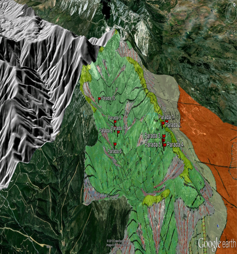
2.1. Situation and Analysis of Geological Context of the Itinerary

The virtual flight itinerary was performed in Batuecas Valley (Figure 1), with the idea that potential participants have the opportunity to discover a place of great natural and geological heritage, that serves as a physical basis for the rest of the natural heritage: biological, ecological and cultural heritage within the protected “Batuecas-Sierra de Francia” national reference in the natural and social environment. This sector presents geological features conditioned by the different events of its geological history, as indicated in the results section.
Figure 1. Study area.
Sustainability 06 08567 g001
The analysis and distribution of different geological materials observed in the Batuecas Valley reveal its geological evolution over time based on paleogeographical and paleoenvironmental data. The oldest materials formed by the schist grauwacke complex (upper Precambrian-Cambrian; lower age more than 500 million years-m.y.), which is composed of shales, sandstones, conglomerates, and black shales, are interpreted as a submarine fan depositional environment that underwent profound shallowing [24].
The sandstone and limestone indicate a marine environment platform of archaeocyathids fossils, which indicates shallow and warm waters; these materials were deposited during the Cambrian (485–541 m.y.). Additional materials formed on top of the previous ones, which appear from the Ordovician age (485–443 m.y.), consist of sandstones, conglomerates, quartzites and gray and black shales, which indicate a detrital platform with subtidal conditions.
The Silurian (443–419 m.y.) deposits consist of slates and quartzites with interbedded volcanic rocks from the Devonian age, which corresponds to a deeper sea carbonate sedimentation sludge from remnants of the shells of organisms. Laurasia is formed at the end of the Devonian and Carboniferous and during the formation of a large supercontinent (Pangaea) generated by the collision of the large continent Gondwana (which is attached to the Iberian plate) with another supercontinent originates. This collision generates the Variscan Orogen, which consists of folding and deforming materials in a retreating sea area.
During the Cenozoic a new collision between Eurasian and Iberian plates generates the Alpine Orogeny, in which Pyrenees and reactivating Variscan fractures of the current and subsequent periods emerge, resulting in blocks that sink and rise like piano keys and new reliefs that settle to the Paleogene (65.5 to 23 m.y.). During the Neogene (23 to 2.58 m.y.), the saws undergo erosion forming conglomerate alluvial fan systems, which continues until the Quaternary (2.58 m.y.-present). A change in the sediment dynamics, followed by a fluvial incision of the alluvial fans take place, the current relief having deep valleys, like that of Las Batuecas , is generated.
The relief of the study area (Figure 2) is the result of varisc folding with soft curved type synclinal structures with steep and strong slopes, which produces an “Appalachian” relief (anticlines and synclines in high areas and topographically low areas). Formations are also seen due to differential erosion controlled by competition or resistance to different lithological formations, such as the quartzite formations, which are noted for their hardness. In these outcrops of quartzites, inorganic structures (such as asymmetric and symmetric ripples waves, lenticular stratification, cross-bedding, and parallel lamination) and organizational structures, such as trace fossils or tracks that reflect the behavior of organisms (displacement, nutrition, housing, and predation) are evident in a shallow marine paleoenvironmental coastline subjected to waves. Skolithos, which are clustered distributions of worms caused by the use of home, are observed perpendicular to the stratification and are also inclined by the tectonic effect. Cruzianas, which consist of offset marks on sandy substrate trilobites, were observed and striated Daedalus is attributed to a “cesspool” of marine worms.
Figure 2. Digital terrain model and geological map on a 3D orthophoto of Batuecas Valley. Color key: dark green-Ordovician quartzite, light green-Ordovician quartzite, orange-granitic intrusion, gray-Quaternary screw, and black lines-fractures and lineation structures.
Sustainability 06 08567 g002

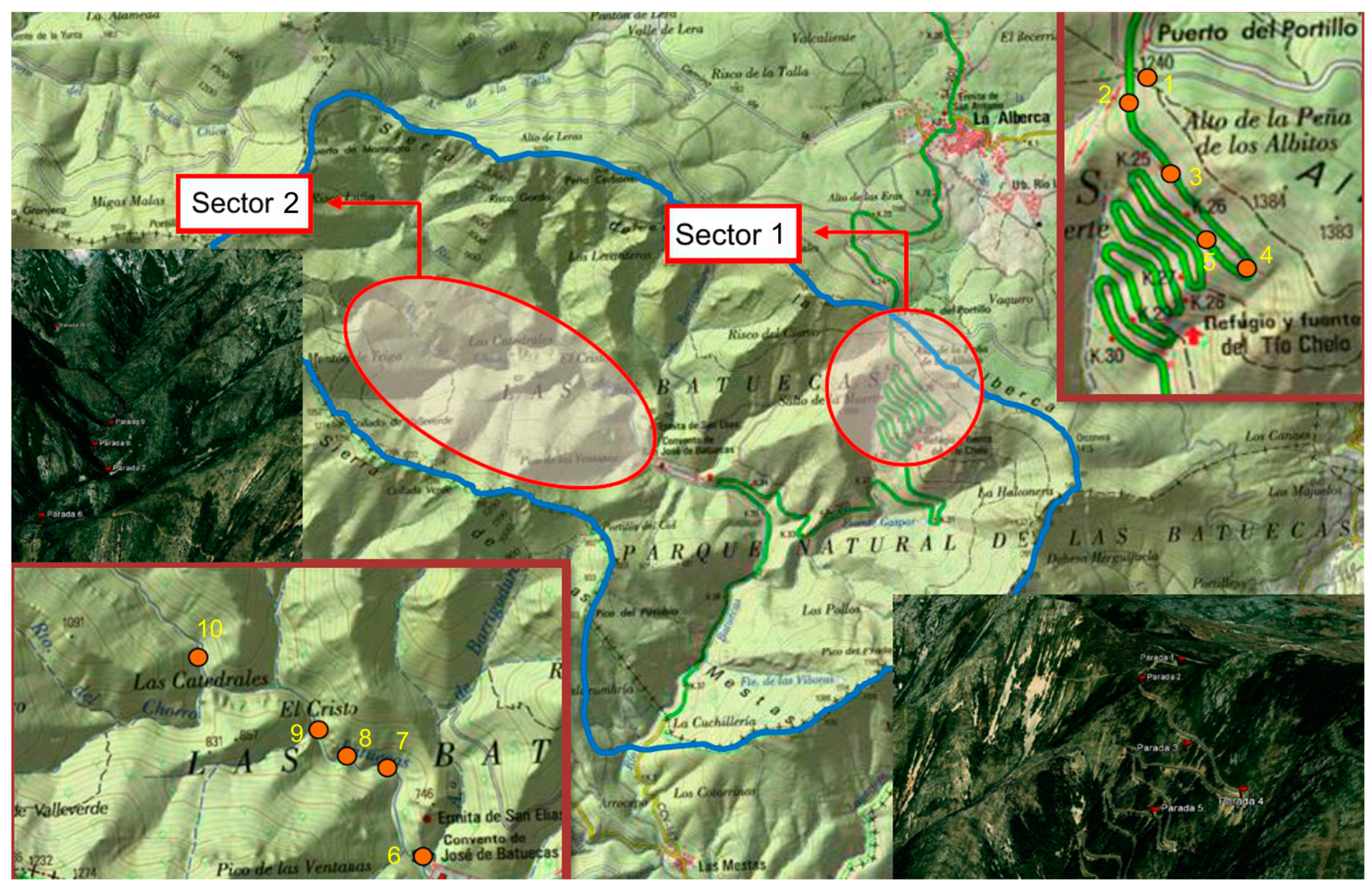
2.2. Inventory and Cataloguing of Geosites

A field trip was conducted to identify potential stops in this area with multiple values, which are likely to be used for teaching and the assessment. From field observations and different publications (thesis and scientific articles), ten representative points, which were tailored to the educational level of the participants, were selected. Points that could not be included in the proposed itinerary were discarded.
At each stop, a geosite or tab (Figure 3, Side A) in which side A—point location on the topographic mapping and orthophotography—is present, the UTM coordinates and description of existing geological interest is performed with representative photographs of the geological event. On the other side, the valuation parameters, which conform to the methodology proposed by the IGME, are established to develop the Spanish Inventory of Sites of Geological Interest [5]. This valuation is based on three criteria [10]: the intrinsic value (T1), the value of potential use (T2) and the value of the need for protection (T3). The latter criterion is a parameter used to evaluate the locations that were previously selected based on their values in the first two criteria. Due to the influence of the assessment, some parameters, such as proximity to population centers and accessibility, which is inversely proportional to the assessment of the potential use, erroneous results may occur if locations are assessed concurrently. The potential use of scientific, educational and/or tourist/recreational groups leads to places of geological interest and prevents the exclusion of geosites that do not achieve a minimum value in the sum of T2. Therefore, geosites are rated according to their core values and their potential use and the most vulnerable geosites are subsequently evaluated to prioritize the need for protection [12].
To assess the intrinsic value (T1), the various parameters [11] are weighted from 0 to 4 points (the value 0 is attributed to the location with a minimum interest value less than 1, which is dependent on the features of each stop; Table 1).
Table 1. Parameters that define the intrinsic value and the weighting (T1).
ParametersIntrinsic value
Representativeness (quality of location to adequately illustrate the features of the domain)
Useful as a model to partially represent a trait or process1
Useful as a model to represent a trait or process2
Best-known example and geological domain level considered to represent a trait or process4
Character type locality or benchmark (quality of place as a stratigraphic, paleontological, and mineralogical reference)Intrinsic value
Useful as a model to partially represent a trait or process1
Useful as a model to represent a trait or process2
Best-known example and geological domain level considered to represent a trait or process4
Level of scientific knowledge of the location (geological relevance and scientific interest in publications and studies)Intrinsic value
Published studies and/or doctoral thesis about the location1
Focus of research by scientific teams and the subject of doctoral theses and published papers that have been referenced in national scientific journals2
Focus of research by scientific teams and the subject of doctoral theses and published papers in international journals4
State of conservation (existence of physical deterioration of the trait)Intrinsic value
With impairments that prevent appreciation of some features of interest1
Some defects, which do not decisively affect its value or interest2
The geosite is well-preserved4
Viewing conditions (offered by the environment to observe the trait).Intrinsic value
Contain elements that do not enable appreciation of some features of interest for the geosite1
Contain elements that do not enable complete observation of the geosite, despite the difficulty2
Perfectly and easily observable in its entirety4
Rarity (shortage of similar traits as described)Intrinsic value
One of the few known examples at the regional level1
Only example known at the regional level2
Only example known at the national level (or international level) 4
Geological diversity (the existence of various types of geological interest in the same location)Intrinsic value
The geosite has other interests in addition to the primary interest, which are not relevant1
The geosite has two types of interests in addition to the primary interest, or only one relevant interest2
The geosite has three or more types of interests in addition to the primary interest but only two interests are relevant4
Educational content/educational use identified (trait is easily taught or already used for this purpose).Intrinsic value and use
Illustrates university content of curricula1
Illustrates curricula at all levels of the educational system2
Commonly used in educational activities at all levels of the educational system4
Logistics infrastructure (Existence of lodging and restaurants)Use value
Accommodations for groups with 20 people within 25 km1
Accommodations for groups with 40 people within 25 km2
Accommodations for groups of 40 within 5 km4
Population density (demand immediate potential) (Linked to the potential number of visits and the increased potential for vandalism)Use value and protection
Less than 200,000 inhabitants within 50 km1
Between 200,000 and 1,000,000 inhabitants within 50 km 2
More than 1,000,000 inhabitants within 50 km4
Accessibility (Linked to easier access and a greater potential for vandalism)Use value and protection
Direct access by dirt road but passable1
Direct access by paved road with parking for cars2
Direct access by paved road with parking for coach buses4
Intrinsic fragility intrinsic vulnerability of the location due to its size or nature (deposits)Use value and protection
Not vulnerable as visits but more sensitive to human activities and decametric aggressive traits1
Hectometric features that may experience deterioration by human activities2
Kilometric traits that are not damaged by human activities4
Association with other nature/cultural elements. The site also does not contain other elements of geological interest.Use value
Presence of a single element of natural or cultural heritage within 5 km1
Presence of various elements of natural and cultural heritage within 5 km2
Presence of various elements of natural and cultural heritage within 5 km4
Visual beauty or spectacular trait or qualityIntrinsic value
Used only in the local tourist iconography1
Used occasionally in the tourist iconography at the national or international level2
Typically used in the tourist iconography at the national or international level4
Informative content/use detected. The feature is easily identifiable or already used for this purposeIntrinsic value and use
Demonstrates clear and expressive manner for groups of certain cultural levels1
Demonstrates clear and expressive collective cultural level any way about the importance or usefulness of geology2
Commonly used for outreach activities4
Potential for tourism and recreational activities. The location satisfies the conditions for conducting activities or is already used for this purposeIntrinsic value and use
You can make develop one of these activities1
You can perform these activities2
These activities are usually organized4
Proximity to recreational areas (demand immediate potential) Linked to the potential number of visits and the increased potential for vandalismUse value and protection
Geosite located within 5 km of a recreational area (campsites, popular beaches, national or natural parks, and visitor centers)1
Geosite located within 2 km of a recreational area2
Geosite situated within 500 meters of a recreational area4
Socioeconomic environment. Socioeconomic conditions that favor its use as a factor of local developmentUse value
Region with per capita income levels, education and occupation similar to the regional average but below the national average1
Region with per capita income levels, education and occupation below the regional average2
Site located in a region with socioeconomic decline4
The weighted values for each parameter are based on the weighting coefficients (Table 2). The value for each parameter in Table 1 and for each of the proposed stops indicated by the weighting coefficient yield a total value that represents the scientific, educational, and/or tourist/recreational interest, which can be used to quantify the value of each stop as the potential use (T2).
Table 2. Weights for each parameter as a function of interest (T2).
ParameterScientific interestEducational interestTourist/recreational interest
Representativeness255---
Character type locality205---
Degree of scientific knowledge of the location15------
State of conservation105---
Viewing conditions555
Rarity155---
Geological diversity1010---
Learning objectives/educational use---20---
Logistics infrastructure---155
Population density---55
Accessibility---1510
Intrinsic fragility------15
Association with elements natural and/or cultural---55
Beauty or spectacularity ---520
Informative content/use------15
Potential for tourism/recreation activities------5
Proximity to recreational areas------5
Socioeconomic environment------10
TOTAL 100100100
Each parameter is weighted from 0 to 4, according to the scales shown in Table 2. Thus, three groups of geosites are established: geosites with a value greater than 200 (high interest), geosites with values that range from 101 to 200 (average interest) and geosites with values less than 101 (low interest). As the location of some geosites (proximity to areas with vehicular traffic and road embankments), it was considered appropriate to assess the vulnerability (T3) for these geosites using a methodology similar to the intrinsic value T1 (Table 3).
Table 3. Parameters for assessing the vulnerability of geosites (T3).
ParametersValue
Anthropic vulnerability/existence of anthropogenic threats
Location situated less than 100 meters from a road, less than 1 km from an industrial or mining area, less than 2 km from urban land in cities with less than 100,000 inhabitants or less than 5 km from older populations1
Location adjacent to an industrial or mining area, adjacent to urban or undeveloped land, or located within 25 km of a road2
Located in a mining area (active and abandoned), on the slope of a road or on urban land4
Interest in mining/interesting in the mining of outcropping materials
Substance is of minimal to moderate interest with farms in the area1
Substance is of significant interest with farms in the area2
Substance is of significant interest with no alternative holdings in the area4
Natural vulnerability. Existence of natural hazards (active processes)
Feature (s) vulnerable (s) to physical and chemical weathering1
Location affected by active processes (erosion, flooding, and land movement) of moderate intensity2
Location affected by intense active processes4
Intrinsic fragility/intrinsic vulnerability due to its size or nature (deposits)
Hectometric to kilometric traits that may experience deterioration by human activities1
Decametric traits that are not vulnerable to visits but are sensitive to more aggressive human activities2
Paleontological or mineralogical capability of plundering 4
Protection regime instead of possible protection depending on location within or outside a protected area
Location with no form of protection but subject to management plan without care or cultural interest due to its paleontological/archaeological content1
Location located in rural area with the preservation of land by its transformation through planning and urbanization of the town and country2
Figure location that lacks any type of protection4
Physical protection or indirect physical difficulties of access to the site
Easily accessible and located far from paths and camouflaged by vegetation1
Easily accessible and only camouflaged by vegetation2
Location lacks any type of indirect protection4
Accessibility (potential aggression) linked to the need for protection against vandalism
Direct access by dirt road but passable1
Direct access by paved road with parking for cars2
Direct access by paved road with parking for coach buses4
Ownership of the location: private, public repositories or restricted
Geosite located in public areas and areas with restricted access1
Geosite located on private property and areas with restricted access2
Geosite located in public areas or private property repositories4
Population density (potential aggression). Need for protection by increasing the likelihood of vandalism
More than 100,000 inhabitants but less than 200,000 inhabitants within 50 km1
Between 200,000 inhabitants and 1,000,000 inhabitants within 50 km2
More than 1,000,000 inhabitants within 50 km4
Proximity to recreational areas (potential aggression). Presence of recreational or tourist areas and linked to the increased possibility of vandalism
Geosite located within 5 km of a recreational area (campsites and beaches)1
Geosite located within 2 km of a recreational area2
Geosite situated within 500 meters of a recreational area4
The intrinsic value of some parameters of vulnerability (accessibility, population density or fragility) have been analyzed, as shown in Table 1. However, in Table 3, the parameters are analyzed in reverse as, for example, greater accessibility increases the potential of visitors but can be considered to be detrimental due to agglomeration or vandalism. Similarly, we have established a set of relative weights for vulnerability (Table 4), which yield a total value for priority protection.
Table 4. Weights for each parameter of vulnerability (T4).
ParameterWeights
Anthropogenic threats15
Interest in mining15
Natural hazards15
Intrinsic fragility10
Protection regime 10
Physical or indirect protection10
Accessibility10
Ownership of the location5
Population density5
Proximity to recreational areas5
TOTAL 100
By applying simple formulas, we have calculated the value of priority of protection (PP) to establish preventive measures that can be used to conserve these geosites for future use by students in various fields of practice or for the use and enjoyment of a geotourism that is sustainable by the inhabitants of this natural area and tourists arriving in this region. We used the following Equations (1):
PP scientific = scientific interest (Ic) + Vulnerability (V)
PP educational = educational interest (Id) + Vulnerability (V)
PP tourist/recreational = tourist/recreational interest (It) + Vulnerability (V)
[PP = [(Ic + Id + It)/3] + V]
To prioritize the protection of each geosite, the value of vulnerability must be added to the value of its scientific, educational or tourist/recreational interest, which enables sorting of the geosites according to their global interest and priority protection into three sections: if 201 < PP < 500 points, short-term and medium-term protection is recommended; however, if PP < 201 points, specific protection through legislative action is not required (Figure 3, Side B).

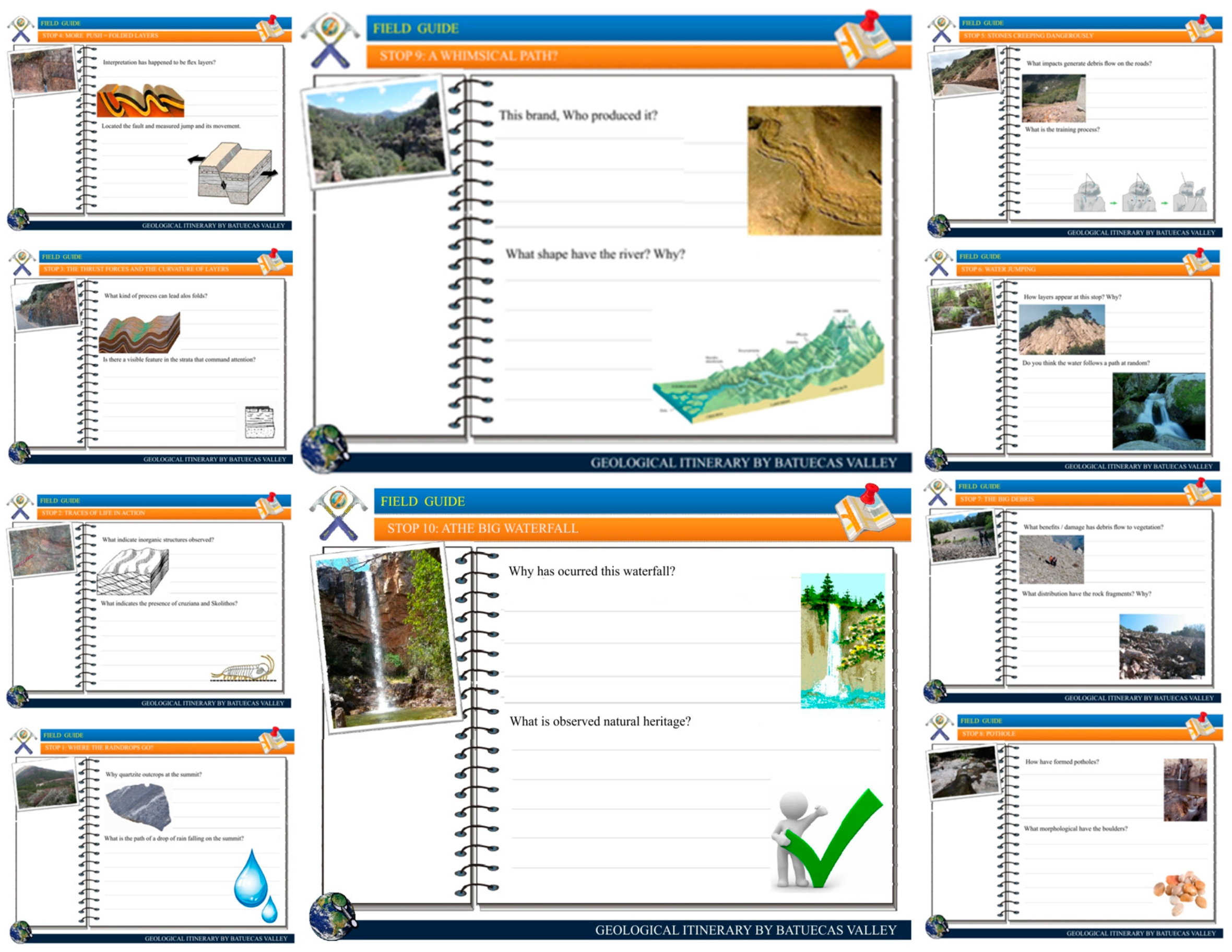
2.3. Educational Resources: Field Guide

From the descriptive material (coordinates and field data) and graphics (photographs and diagrams) obtained on a previous trip, three sessions were conducted to design the questionnaires for each geosite; the questions ask the participants for results using the process of observation and interpretation of forms, geologic materials, structures and footprints at each stop along the itinerary, which enable the participant to propose the main idea or geological concept [25,26]. Two issues to be developed for each geosite are recorded in a field book in printed or pdf format (Figure 4), which is downloadable via a teaching platform of the subject or created by a QR code printed on each geosite in the field notebook. A description of the development results by the participant, which is obtained through this process of teaching and learning, is included at the end of the book. From the resource processing, different themed itineraries, which comprise mixed geopath of different specialties, are created to enable teachers, students, tourists, and hikers to access this documentation, which adds value to natural geological resources in areas of significant naturalness and fragility. This digital or paper field notebook should include recommendations regarding geological heritage, which is considered to be a nonrenewable resource; therefore, the prohibition of the removal or damage of georesources and rules on behavior (noise, waste, and hiking) in these places should be protected.

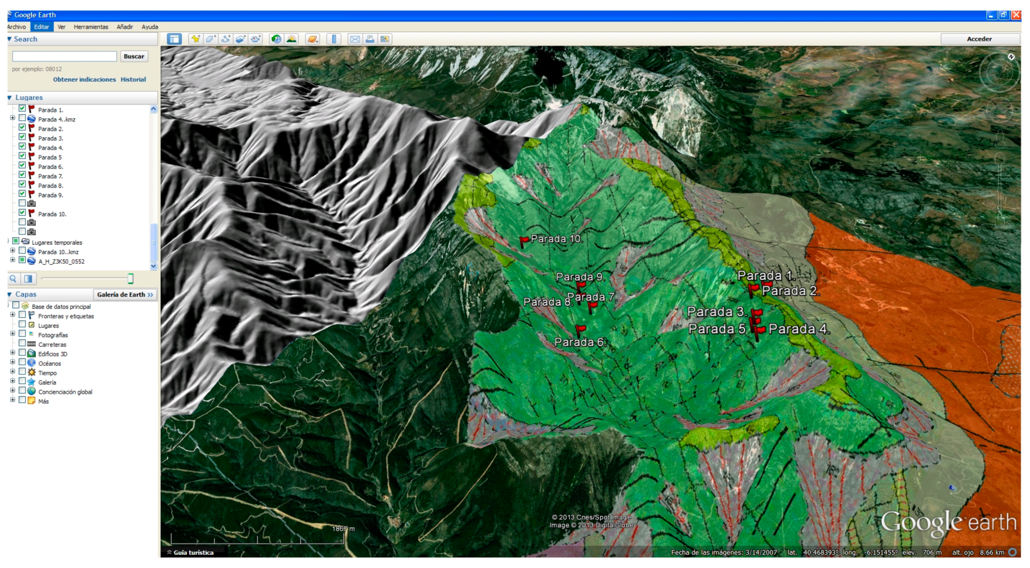
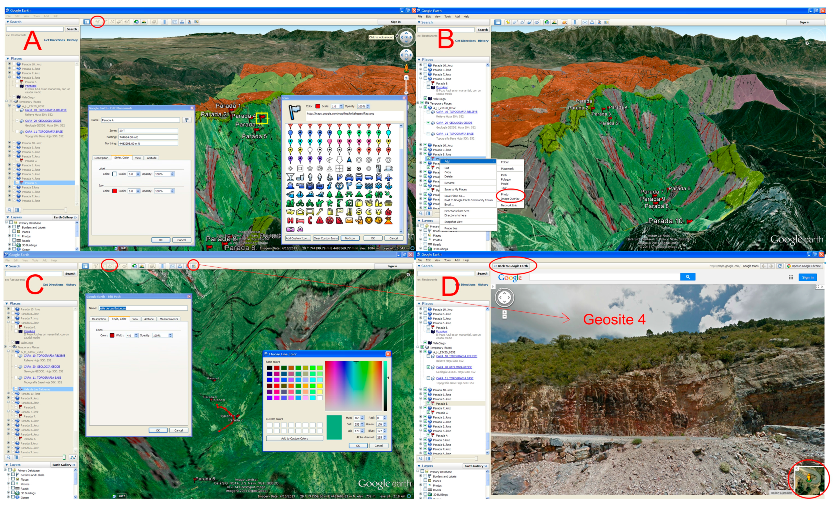
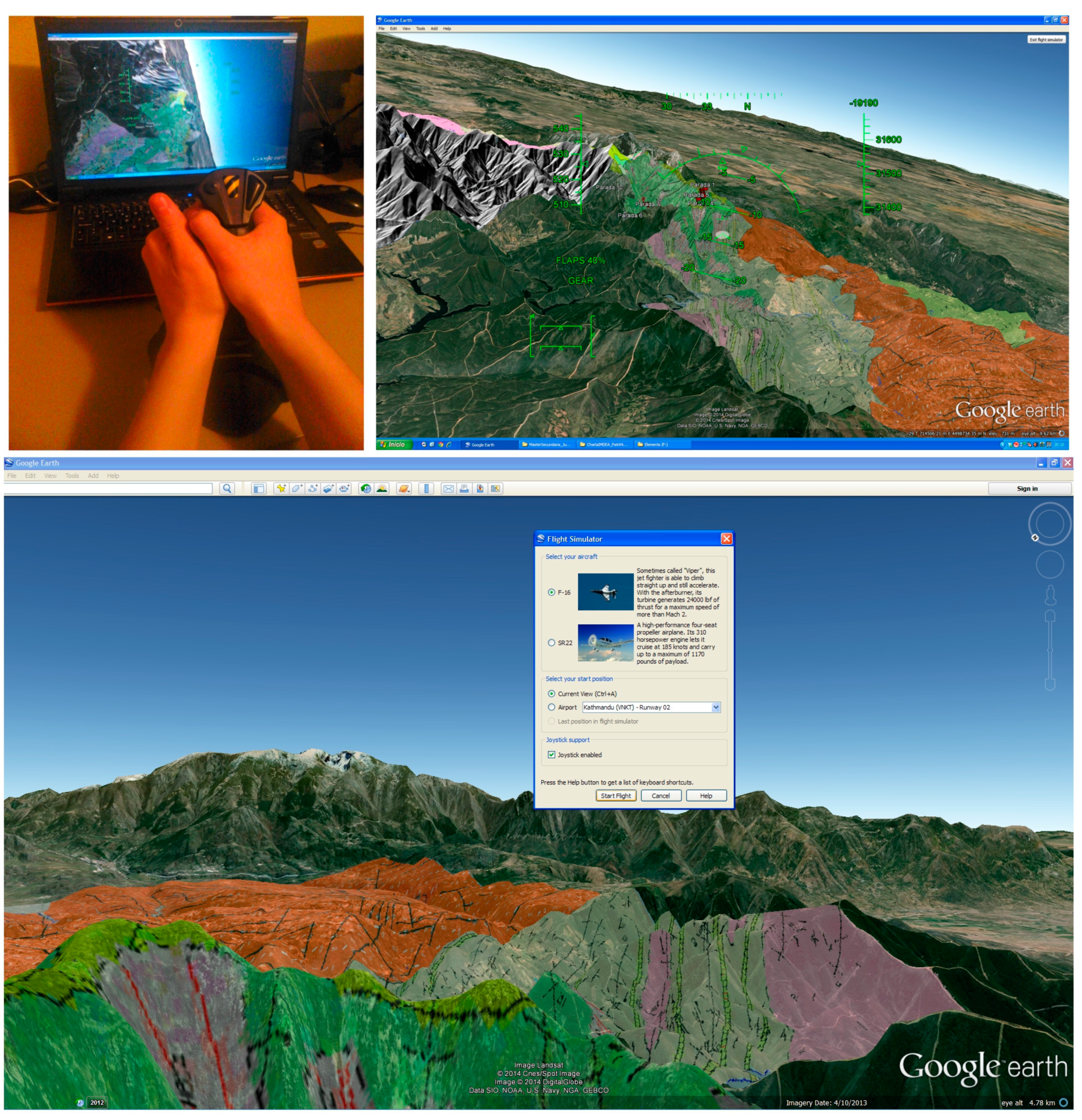
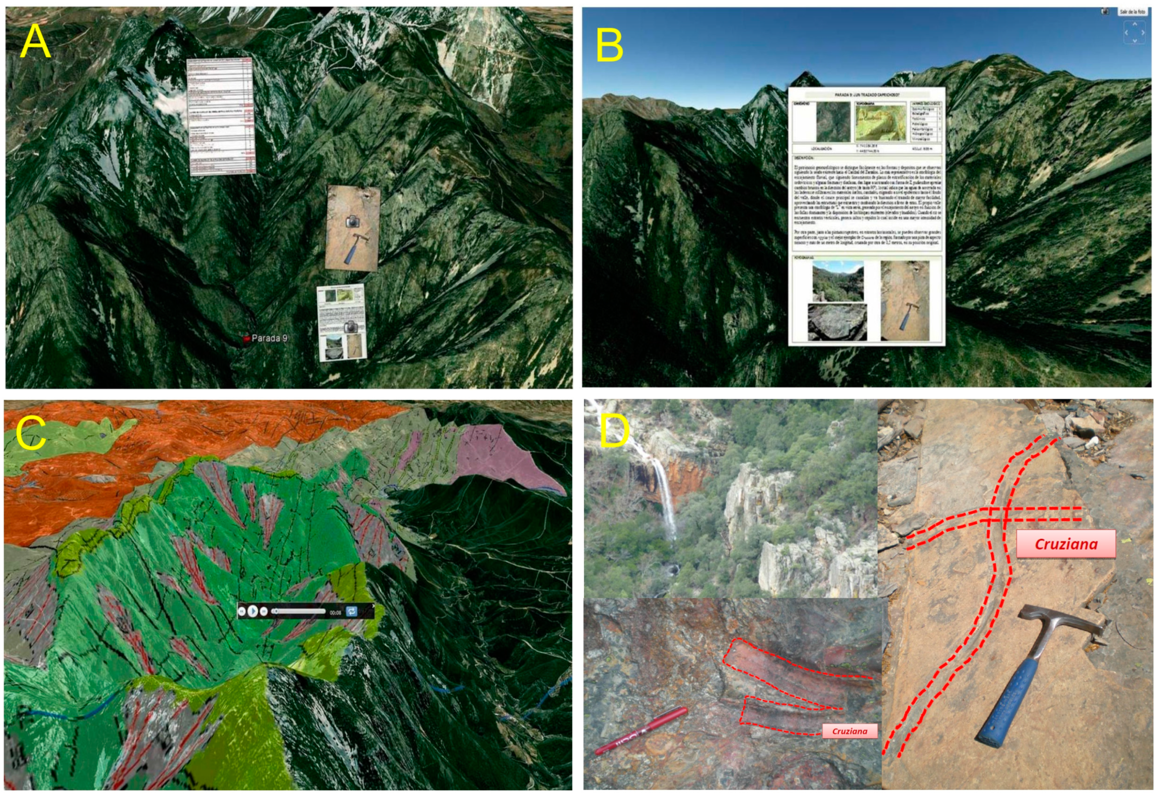
2.4. Preparation of Itinerary Using Google Earth and 3D Virtual Flight

Once identified, catalogued and rated, the itinerary of the 10 geosites in the Batuecas Valley can be georeferenced. A placemark is displayed at each stop using their spatial coordinates and a description associated with the window position. Each placemark can be represented with different shapes and colors, which are available in the Google Earth application (Figure 5A). As each stop is saved in “kmz” format, when you open the file, the Google Earth platform opens and automatically georeferences a stop [14,22]. Subsequent geological mapping in Google Earth was loaded into ortho overlap, in which a user can zoom “+” or “−” to approach or move away from a geosite to analyze the geological context of the sector study and provide a spatial overview of the itinerary, which is displayed using different 3D geological materials by observing their topographic position and lithologic sequences.
To enrich the virtual path in the table of contents (TOC) of Google Earth (left bar of the application) via the “add” option (Figure 5B), graphic documentation of the different valuation records revolves with field photographs. Once loaded, all virtual information (geosites, chips with ratings, and pictures) is needed to scan the path using the "add path" button on the top menu of Google Earth (Figure 5C), which colors the route alignment with varying thicknesses and line types in the popup. The extensive interoperability of this free browser enables interaction with the “Google Maps” application called “Street View”, which can be used to virtually analyze road profiles, structures and/or “in situ” school outcrops (Figure 5D).
A 3D virtual flight is conducted from the “record a tour” command on the Google Earth menu using a USB-type Thrustmaster joystick with 3 axes and 4 buttons for complete control, a point of view perfect button for camera control and immersion in Google Earth, and an ergonomic handle with an enlarged rest hand and thumb throttle for speed control. The flight comprises a tour of the geological mapping according to the marked route from the geosites. It simulates a game, in which the participant selects the type of plane in the Google “tools” menu button to “enter flight simulator” (Ctrl + Alt + A) with direct flight in the study area or by taking off from a particular airport to watch the different views. These virtual flights are recorded using the free Google Earth platform and can be played in different formats (avi. and mpeg.) They are compatible with new technologies (smartphones, personal computers, iPads and tablets) and common domestic players (DVDs and CDs). Deployment with a free browser, such as Google Earth and Terra Explorer, is simple and accessible from any school by the Internet or “Wi-Fi” with new mobile technologies to facilitate the visualization of itineraries by potential users [26,27] and young participants, which increases their interest for presenting the activity in a familiar environment, such as with video games [28,29].
Figure 3. Sheets in which sides A and B depict the proposed itineraries of observed geosites.
Sustainability 06 08567 g003
Figure 4. Field guide with questionnaires about different geosites.
Sustainability 06 08567 g004
Figure 5. Commands used for the implementation of the different virtual resources.
Sustainability 06 08567 g005

3. Results and Discussion

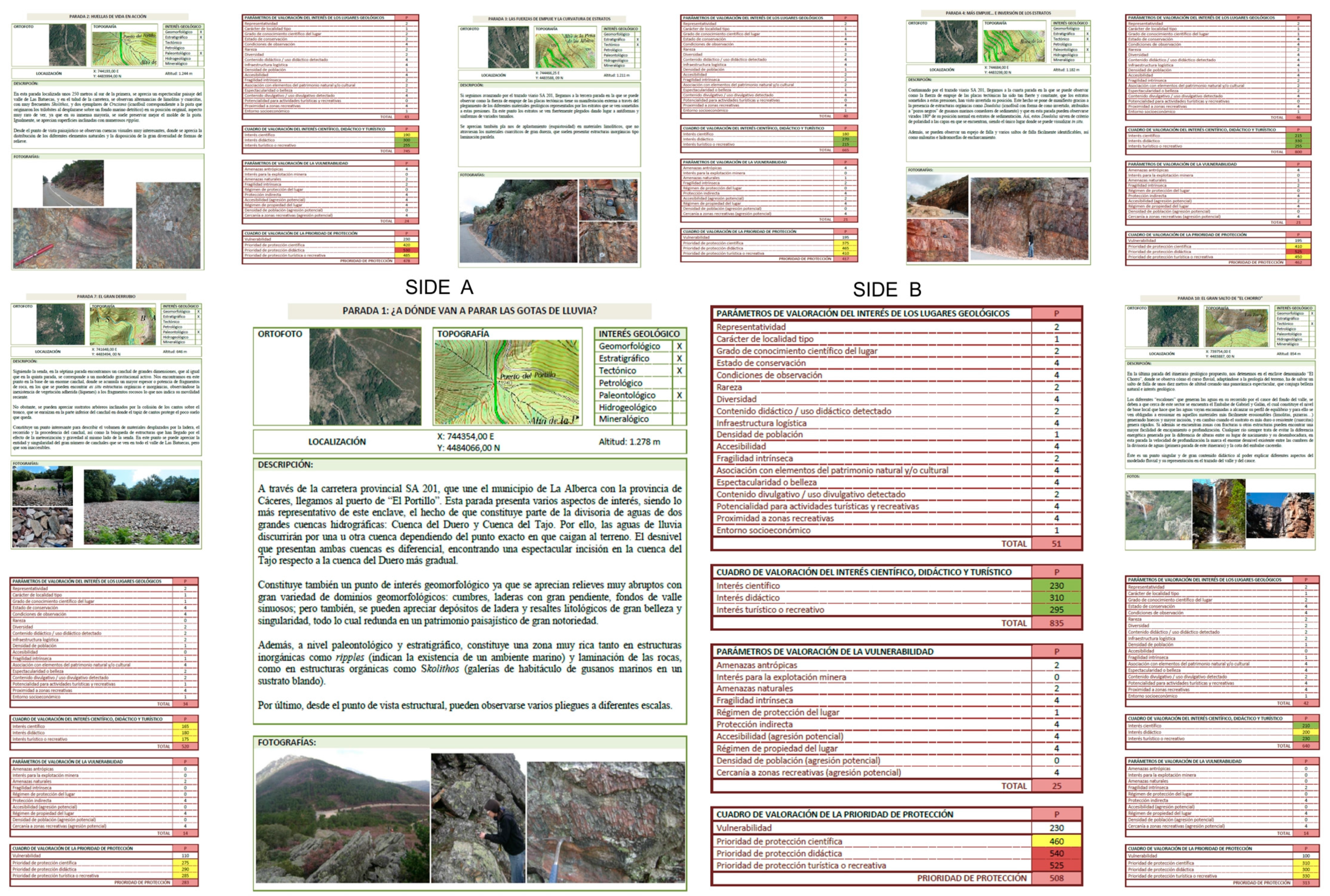
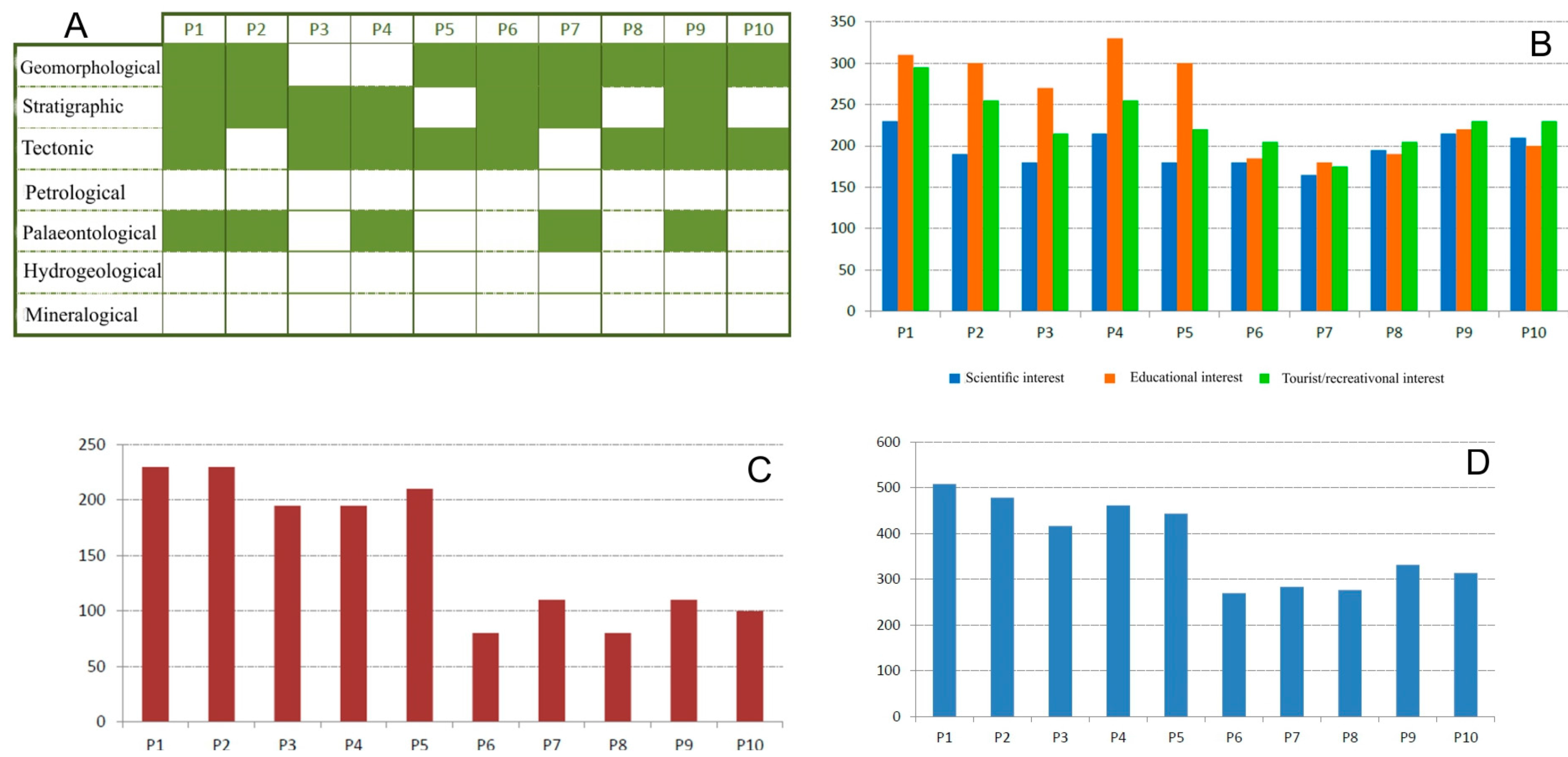
3.1. Inventory, Cataloguing and Assessment of the Stops on the Itinerary

Ten stops were divided into two distinct areas: the first area is located in the watershed north of the stream basin of the Batuecas Valley, in which five stops are located along the downstream side, and the second area is located on the bottom of the valley. The first area is more accessible as its display is directly obtained from a tour of the road, whereas the second are is obtained from a tour of a trail, in which some of the stops are not shortcuts as you have to deviate from the main route. However, as these sites are located at a sufficient distance from each other, people who set out to discover an area of great beauty and multiple interests, observe not only geological features but also faunal, botanical, and cultural features.
To proceed with the evaluation of geosites with a vast amount of data and to facilitate the analysis of interest and vulnerability, a table of different parameters and variables is created and a graph that displays the data analysis is produced (Table 5).
Table 5. Assessment of the parameters and variables for the all geosites.
P1P2P3P4P5P6P7P8P9P10
Parameters for assessment of geosites
Representativeness2222222222
Character type locality1111111111
Degree of scientific knowledge about place2211111112
State of conservation4244444444
Viewing conditions4444444444
Rarity2212110222
Geological diversity4224222242
Learning objectives/educational use2444422222
Logistics infrastructure4444422222
Population density1111111111
Accessibility4424400000
Intrinsic fragility2222121211
Association with elements of nature/culture heritage4222244444
Beauty or spectacularity4212122244
Informative content/use2444422222
Potential for activities tourism/recreation4000041444
Proximity to recreational areas4444444444
Socioeconomic environment1111111111
Assessment of scientific, educational and tourist/recreational interest
Scientific interest230190180215180180165195215210
Educational interest310300270330300185180190220200
Tourist/recreational interest295255215255220205175205230230
Total835745665800700570520590665640
Parameters for vulnerability of geosites
Anthropogenic threats2444400000
Interest in mining0000000000
Natural hazards2211202020
Intrinsic fragility4222220222
Protection regime 1000000000
Physical or indirect protection4444424224
Accessibility (*)4422200000
Ownership of the place4444444444
Population density (*)0000000000
Proximity to recreational areas (*)4444444444
Total25242121221214121414
Assessment of vulnerability and protection priority
Vulnerability2302301951952108011080110100
Scientific protection priority460420375410390260275275325310
Educational protection priority540530465525510265290270330300
Tourist/recreational protection priority525485410450430285285285340330
Protection priority508478417462443170283277332313
Note: “*” potential aggression.
The different stops are analyzed to develop the most appropriate stop to correspond with the theoretical content taught in the actual classes of the subject (Figure 6A) geological disciplines, which enables the creation of specific routes around a theme based on the training block of the group of participants, where observable features at these stops are significant to the understanding and learning of these blocks. From the quantitative assessment of the stops, we can establish whether a particular stop has a scientific interest for pre-university or university participants, or if a stop is didactic and complemented by a tourism and recreation interest from an environmental point of view (Figure 6B). This route highlights the educational interest for the first 5 stops and indicates that all stops in both sectors have high values.
Students can assess and calculate the degree of vulnerability of each geosite (Figure 6C) and determine their priority for protection (Figure 6D). The vulnerability of the geological elements in each geosite to anthropogenic and natural action shows that the stops in the first sector are located next to the road infrastructure, whereas the accessibility in the second sector is reduced to walkers who are at risk of potential attacks. This accessibility shows a need for protection of the geological features of the first five stops.
Figure 6. (A) Type of geological interest at each stop (P1, P2,…, and P10); (B) Ratings for the different types of interest at each stop; (C) Assessment of the level of vulnerability of each stop on the itinerary; (D) Priority ratings for each stop protection.
Sustainability 06 08567 g006

3.2. Inventory, Cataloguing and Assessment of the Stops on the Itinerary

Conducting educational activities at each stop by a field guide facilitates the development of ideas and concepts and the reinforcement of visual surveys to ensure the proper functioning of the teaching and learning processes. This field guide presents 10 records, in which two questions are asked at each stop, with an outcrop photo or a sequence of patterns of natural processes that occur at the stop, which informs the educator whether the participant understands the main idea of each stop. The text incorporates part of a simple and understandable colloquial description and gradually includes geological terms to facilitate understanding. For example, we subsequently developed only two stops: one stop in sector 1 (geosite 1) and a second stop in sector 2 (geosite 10):
Stop 1: Why are quartzite outcrops produced at the summit? The main idea is that participants observed the arrangement of the different rock types in the mapping, in which the current relief is the result of differential erosion of geological materials, which surfaced in the toughest peaks; in this case, the material was quartzite. At this stop, the composition of these siliceous rock and mineral association, which exhibit high hardness and metamorphic processes, can also be analyzed.
What is the path of a drop of rain falling on the summit? This stop is the watershed between two major river basins: the Duero basin and the Tajo basin. The participants observe that runoff on the southern slope will descend towards the Tajo basin in the city of Lisbon (Portugal), whereas raindrops that fall a few more feet to the right will follow a path that will be carried to the Duero basin and will lead to the city of Porto (Portugal); both flow into the Atlantic Ocean 300 miles to the north. The geographical demarcation of the watershed is analyzed according to the different paths.
Stop 10: Why has this waterfall occurred? It is a fracture that has at least one fault vertical drop of approximately 10 m. Was coming so far really worth it? The horizontal arrangement of stratification with the cut perpendicular to the vertical fracture is observed; a “zig-zag” path of riparian vegetation is observed towards the valley, which follows the course of the recognized river and is the result of water following a path of least resistance to erosion, which is dependent on the type and hardness of the bedrock that is traveling towards water.

3.3. Itinerary and 3D Virtual Flight

Using the Google Earth browser, ten geosites that incorporate the information available at each stop have been located, properly georeferenced, and digitized from records and diverse graphic and descriptive documentation, as previously mentioned and collected during the field work (Figure 7A). This study has generated a virtual flight that enables visits to actual places and the acquisition of geological contexts and relationships to other points of natural interests; the itinerary can be also modified in real time. This virtual tour can be shared with anyone via the web using similar software and can also be used in geo-portals. Using emerging technologies (smartphones, tablets, and iPads), students, teachers and the general public can directly access this path from these devices [29], which promotes an accessible, active and sustainable geotourism through an augmented reality with an enhanced geological heritage. This virtual 3D flight situation provides the user with a geological context on a georeferenced overlay for ease of situation with 30% transparency on the orthophotography, enables the user to fly over a distribution of different lithologies and associated structures, and enables the user to change sheets at every geosite (geomorphological units such as steep slopes with the development of scree, summits and ropes, are highlighted watersheds with erosion-resistant quartzites) (Figure 7B), whereas the spatial arrangement of the elements, such as valley bottoms where runoff deepens, with waterfalls in the Batuecas stream are observed, for transverse fractures of the valley, surrounded by prominent reliefs that generate natural landscapes of significant beauty, favored by a microclimate due to the topographic difference of 650 m between geosite 1 and geosite 6.
This flight is saved as associated with a Google Earth file, which enables a user to play it at any time, project various videos made a few minutes but in different areas of the Batuecas Valley with a different spatial resolution (approaching or retreating flight to the ground surface). To implement the lectures or route information, these virtual flights are recorded as “avi” or “mpeg” files (Figure 7C), which are compatible with any video player or computer and facilitates the use of various presentation software by teachers (Power Point), the incorporation of photographs and interpretive schemes of organic and inorganic structures, and geodynamic processes for images taken in the field (Figure 7D).
From the superposition of several thematic layers on 3D virtual globe in raster format (orthophotos) and vector polygons (geologic mapping), line (route) and points (geosites), a trip is made with the flight simulator by selecting a model airplane and flying over the study area, activating altitude and flight control screen commands (Figure 8), taking a trip manned by three-dimensional modeling of the relief, automatically displaying the descriptive geological information screen as we approach each geosite, and following the route traced. It is possible to superimpose several layers of different thematic mappings (landscape, vegetation, and climate) to perform a comprehensive analysis of the physical environment of the Batuecas Valley.
Figure 7. (A) 3D virtual flight inside Batuecas Valley with photographs and valuation tables for the geosite; (B) Detailed description of the sheet in geosite 9; (C) Capture of the flight in “avi” format; (D) Interpretations of the photographs of organic structures and the morphostructural modeling of geosite 10.
Sustainability 06 08567 g007
Figure 8. 3D virtual flight over the study area using a flight simulator and a joystick.
Sustainability 06 08567 g008

4. Conclusions

The conceptual development and degree of understanding achieved by students in teaching-learning courses in the Earth sciences in engineering is highly effective if the contents of the “curriculum” are analyzed in the natural laboratory, such as itineraries of geosites that are representative of different geological processes and events. This paper presents a methodology to develop geological itineraries of natural areas that give value to geological heritage as well as provide educational resources and virtual 3D flight, which enables the educational center to integrate the geological context in the relief, which is developed by virtual balloons and augmented reality.
Internet browsers, such as Google Earth, assist students in the spatial visualization of thematic maps (geological, geomorphological, and stratigraphic). The implementation of innovative educational resources and new technologies stimulates creativity and knowledge for the rapid acquisition of a greater degree of collaborative, autonomous and interactive skills, which introduces the development of a flight simulation game to the teaching-learning process. This methodology represents a practical perspective for the curriculum using a technological approach to the processing and transmission of information using daily interaction amongst social groups in familiar digital formats (images, videos, and augmented reality by Wi-Fi).
The geological itinerary for the Batuecas Valley identifies and evaluates ten geosites of high geological interest and highly scientific, educational and tourist/entertainment content. It was implemented using Google Earth to encourage and enhance the cartographic spatial analysis and specific innovative educational resources, such as 3D virtual flights, educational materials such as field notebooks, digitized routes that are georeferenced and linked to sheets, valuation tables, photos, and QR codes using geomatic applications. The implementation of this methodology has no cost as the software is free and accessible (Google Earth) to schools and the hardware is installed on the majority of computers in computer labs.
The use of these methods by students in the region studied and by school administrations may enhance sustainable geotourism. The most vulnerable sectors that require geoconservation are established, which is useful for the rational planning of territories with consideration of the biological and socioeconomic components of natural areas.

Acknowledgments

The authors express their thanks to projects LK8C/Diputación Salamanca, CGL2009-11539/BTE, CGL2012-33430/BTE and CGL2012-37581/BTE.

Author Contributions

The presented research was conjointly designed and elaborated the inventory, cataloguing and assessment of the stops by Antonio Miguel Martínez-Graña, José Ángel González-Delgado and Silvia Pallarés; José Luis Goy and Jorge Civis Llovera. The itinerary and 3D virtual flight was generated by Antonio Miguel Martínez-Graña. The discussion were realized conjointly by José Ángel González-Delgado, José Luis Goy and Jorge Civis Llovera. All authors contributed equally in the writing of this paper. All authors have read and approved the final manuscript

Conflicts of Interest

The authors declare no conflict of interest.

References

  1. Martínez-Graña, A.M.; Goy, J.L.G.Y.; Cardeña, Z.C. Natural Heritage Mapping of the Las Batuecas-Sierra De Francia and Quilamas Nature Parks (SW Salamanca, Spain). J. Maps 2011, 7, 600–613. [Google Scholar] [CrossRef]
  2. González-Delgado, J.A.; Martínez-Graña, A.M.; Civis, J.; Sierro, F.J.; Goy, J.L.; Dabrio, C.F.; Ruiz, F.; González-Regalado, M.L.; Abad, M. Virtual 3D tour of the Neogene palaeontological heritage of Huelva (Guadalquivir Basin, Spain). Environ. Earth Sci. 2014. [Google Scholar] [CrossRef]
  3. Gray, M. Geodiversity: Valuing and Conserving Abiotic Nature; Wiley: Hoboken, NJ, USA, 2004. [Google Scholar]
  4. Gallego, E.; García-Cortés, A. Patrimonio geológico y áreas naturales protegidas. Geogaceta 1996, 19, 202–206. (In Spanish) [Google Scholar]
  5. Boletin Oficial del Estado. (BOE). Ley 42/2007 del Patrimonio Natural y de la Biodiversidad. Boletin Oficial del Estado 2007, 299, 151275–51327. (In Spanish) [Google Scholar]
  6. Geoschools. Teaching Geosciences in secondary schools. Available online: http://geoschools.geol.uoa.gr/ (accessed on 4 January 2014).
  7. Goy, J.L.; González-Delgado, J.A.; López-Plaza, M.; Preto Gomes, E.; Zazo, C.; Cruz, R.; Martinez-Graña, A.M.; de Villota, I.; de Bustamante, I.; Civis, J.; et al. Arribes del Duero-Douro (Spain, Portugal): Posibilitéis for the First Iberian cross-border Geopark. In Processdings of Geoeventts, Geological Heritage, and the Role of the IGCP, Murcia, Spain, 5–18 September 2010.
  8. Henriques, M.H.; Tomaz, C.; Sá, A.A. The Arouca Geopark (Portugal) as an educational resource: A study case. Episodes 2012, 35, 481–488. [Google Scholar]
  9. Goy, J.L.; Martínez-Graña, A.M.; Sanz, J.; Cruz, R.; Andrés, C.; de Bustamante, I. Catalogación del patrimonio geológico de los Espacios naturales del Sur de Castilla y León (Salamanca-Ávila, España). Cuadernos del Museo Geominero 2013, 15, 389–400. (In Spanish) [Google Scholar]
  10. Cendrero, A. El patrimonio geológico. Ideas para su protección, conservación y utilización. In El Patrimonio Geológico. Bases Para su Valoración, Protección, Conservación y Utilización; Ministerio de Obras Públicas: Madrid, Spain, 1996; pp. 17–38. (In Spanish) [Google Scholar]
  11. García-Cortes, A.; Carcavilla, L. Documento metodológico para la elaboración del inventario español de lugares de interés geológico (IELIG). Available online: http://www.igme.es/patrimonio/novedades/METODOLOGIA%20IELIG%20web.pdf (accessed on 1 July 2014). (In Spanish)
  12. Bailey, J.E.; Chen, A. The role of virtual globes in geoscience. Comput. Geosci. 2011, 37, 1–2. [Google Scholar] [CrossRef]
  13. Schneps, M.H.; Ruel, J.; Sonnert, G.; Dussault, M.; Griffin, M.; Sadler, P.M. Conceptualizing astronomical scale: Virtual simulations on handheld tablet computers reverse misconceptions. Comput. Educ. 2014, 71, 269–280. [Google Scholar] [CrossRef]
  14. Tao, P.K. Conceptual change in science through collaborative learning at the computer. Int. J. Sci. Educ. 1999, 21, 39–57. [Google Scholar] [CrossRef]
  15. Martínez-Graña, A.M.; Goy, J.L.; Cimarra, C. A virtual tour of geological heritage: Valourising geodiversity using Google Earth and QR code. Comput. Geosci. 2013, 61, 83–93. [Google Scholar] [CrossRef]
  16. Couse, L.J.; Chen, D.W. A tablet computer for young children? Exploring its viability for early childhood education. J. Res. Technol. Educ. 2010, 43, 75–98. [Google Scholar]
  17. De Paor, D.; Whitmeyer, S.J. Geological and geophysical modelling on virtual globes using KML, Collada and Javascript. Comput. Geosci. 2011, 37, 100–110. [Google Scholar] [CrossRef]
  18. Blenkinsop, T.G. Visualizing structural geology: From Excell to Google Earth. Comput. Geosci. 2012, 45, 52–56. [Google Scholar] [CrossRef]
  19. Weng, Y.-H.; Sun, F.-S.; Grigsby, J.D. Geotools: An Android phone application in geology. Comput. Geosci. 2012, 44, 24–30. [Google Scholar] [CrossRef]
  20. Lim, C.P. Global citizenship education, school curriculum and games: Learning mathematics, English and science as a global citizen. Comput. Educ. 2008, 51, 1073–1093. [Google Scholar] [CrossRef]
  21. Esteban-Millat, I.; Martínez-López, F.J.; Huertas-García, R.; Meseguer, A.; Rodríguez-Ardura, I. Modelling students’ flow experiences in an online learning environment. Comput. Educ. 2014, 71, 111–123. [Google Scholar] [CrossRef]
  22. Kucirkova, N.; Messer, D.; Sheehy, K.; Fernández Panadero, C. Children’s engagement with educational iPad apps: Insights from a Spanish classroom. Comput. Educ. 2014, 71, 175–184. [Google Scholar] [CrossRef]
  23. Ibáñez, M.B.; Di Serio, Á; Villarán, D. Experimenting with electromagnetism using augmented reality: Impact on flow student experience and educational effectiveness. Comput. Educ. 2014, 71, 175–184. [Google Scholar]
  24. Díez Balda, M.A. El Complejo Esquisto-Grauvaquico, Las Series Paleozoicas y La Estructura Hercinica Al Sur de Salamanca; Universidad de Salamanca: Salamanca, Spain, 1986. (In Spanish) [Google Scholar]
  25. Zingaro, D.; Porter, L. Peer Instruction in computing: The value of instructor intervention. Comput. Educ. 2014, 71, 87–96. [Google Scholar] [CrossRef]
  26. Richard, M.O.; Chandra, R. A model of consumer web navigational behavior: Conceptual development and application. J. Bus. Res. 2005, 58, 1019–1029. [Google Scholar] [CrossRef]
  27. Kiili, K. Digital game-based learning: Towards an experiential gaming model. Internet High. Educ. 2005, 8, 13–24. [Google Scholar] [CrossRef]
  28. Papastergiou, M. Digital game-based learning in high school computer science education: Impact on educational effectiveness and student motivation. Comput. Educ. 2009, 52, 1–12. [Google Scholar] [CrossRef]
  29. Falloon, G. Young students using ipads: App design and content influences on their learning pathways. Comput. Educ. 2013, 68, 505–521. [Google Scholar] [CrossRef]

