Article

The Effect of the COVID-19 Pandemic on the Distribution of Traffic Accident Hotspots in New York City

1
School of Transportation Science and Engineering, Harbin Institute of Technology, Harbin 150090, China
2
School of Automobile and Traffic Engineering, Heilongjiang Institute of Technology, Harbin 150050, China
*
Author to whom correspondence should be addressed.
Sustainability 2024, 16(8), 3440; https://doi.org/10.3390/su16083440
Submission received: 18 January 2024 / Revised: 9 April 2024 / Accepted: 17 April 2024 / Published: 19 April 2024
(This article belongs to the Special Issue Sustainable Road Transport System Planning and Optimization)

Abstract

:
The COVID-19 pandemic has had a substantial impact on the lives of city residents and has reshaped working patterns, with a concomitant impact on traffic accidents. We correlated data from multiple sources to explore the impact of residents’ mobility and residents’ travel behavior on the spatiotemporal distribution characteristics of urban traffic accident hotspots and its internal mechanism under the impact of the pandemic and subsequent policy measures. The results showed that the pandemic and policy measures inhibited the mobility of residents, had a significant impact on working patterns, and changed the composition structure of the purpose of residents’ travel behavior, which substantially impacted the spatiotemporal distribution characteristics of urban traffic accident hotspots. The quantity of traffic accidents decreased significantly, and the spatial distribution characteristics of urban traffic accident hotspots changed substantially, with accident hotspots changing from the single-center spatial distribution before the pandemic to the multi-center spatial distribution during the pandemic; urban accident-prone areas changed from being mainly distributed in the central business district before the pandemic to being more widely distributed in public service areas during the pandemic. The results of this study may be helpful to better understand the spatiotemporal distribution characteristics of urban traffic accident hotspots and their intrinsic mechanism.

1. Introduction

With the development of the economy and society, the process of urbanization accelerates, the number of residents’ car ownership increases, and the number of road traffic accidents also increases. The report released by the World Health Organization (WHO) shows that road traffic accidents kill 1.35 million people every year all over the world. A previous report shows that road traffic accidents are the number one killer of people aged 5–29 [1]. Road traffic accidents not only cause casualties to individuals but also bring about huge economic and social costs for families and society. These costs include the cost of treatment for the dead and injured, as well as labor lost to the dead, those who are disabled by injury, and family members who need to take time away from work or study to care for the injured. Therefore, the road traffic safety problem is not only a traffic problem but also a global social problem [2].
In order to ensure traffic safety, extensive studies have been conducted from multiple perspectives, such as driver behavior [3], automatic collision avoidance technology [4], and traffic conflict modeling [5,6]. These studies have effectively improved the level of road traffic safety. Contemporaneously, with the development of the geographic information system (GIS), based on massive traffic accident data, more and more scholars are using GIS to carry out spatial visualization of traffic accidents, identify traffic accident hotspots, and determine the potential factors for the formation of traffic accident hotspots. Then, measures are taken to improve the level of road traffic safety.
As is well known, the COVID-19 pandemic has significantly affected the lives of urban residents [7,8]. In the face of the pandemic, governments worldwide reduced urban residents’ freedom to travel by issuing stay-at-home orders and other policy measures to inhibit the further spread of the pandemic. Faced with these restrictions, people have had to change various aspects of their lifestyles. From online office to online education, and from telemedicine to fresh product e-commerce, various new online service patterns have emerged, which not only meet residents’ work and life requirements under changed circumstances but also significantly reduce residents’ travel requirements; these changes have also had a remarkable influence on traffic accidents.
This study used resident mobility data, traffic flow data, and traffic accident data, coupled with the construction of the kernel density estimation model and the Getis-Ord Gi* model. Based on these, this study investigated the spatiotemporal distribution characteristics and evolution of urban traffic accident hotspots before and during the pandemic at different time granularities (that is, taking the year and month as the time interval, respectively) to explore the impact of residents’ mobility and residents’ travel behavior on the spatiotemporal distribution characteristics of urban traffic accident hotspots and its internal mechanism under the impact of the pandemic and subsequent policy measures. The remainder of this paper is organized as follows: Section 2 discusses the literature related to the problem under study. Section 3 presents the data and methods. Section 4 discusses the influence of mobility restrictions during the COVID-19 pandemic on the mobility of residents and urban traffic accidents. Finally, Section 5 discusses the results of this paper and presents future research directions.

2. Literature Review

2.1. Traffic Accident Hotspots

Traffic accident hotspots refer to locations with high-density clusters of traffic accidents. In recent years, based on substantial volumes of traffic accident data and with the help of GIS platforms, in-depth studies on urban traffic accident hotspots have been conducted [9,10,11,12,13]. GIS-based traffic accident hotspot identification methods include the kernel density estimation method, the local Moran’s I, the Getis-Ord Gi* method, and so on [14,15,16]. Some studies focus on highway traffic accident hotspots. Almoshaogeh et al. [17] studied a highway in Saudi Arabia, identified traffic accident hotspots, and proposed road safety improvement strategies. Some studies focus on regional traffic accident hotspots. Erdoğan et al. [18] studied the spatiotemporal distribution of traffic accident hotspots in Turkey and then put forward effective preventive measures. More studies focus on urban traffic accident hotspots. Zhai et al. [19] studied traffic accident hotspots in Los Angeles and explored the influential factors related to traffic accident hotspots. Some scholars have studied traffic accident hotspots from the perspective of roadway features or human factors. Umair et al. [20] used the kernel density estimation method to identify traffic accident hotspots in Rawalpindi, Pakistan, and then used Tobit and multiple regression models to analyze the impact of built environment factors on traffic accidents. The results showed that road conditions, informal stops, footpath/setback encroachments, green belt availability, and traffic sign visibility have some effects on traffic accidents. Al-Aamri et al. [21] conducted a study on traffic accident hotspots of MuscatGovernorate in the Sultanate of Oman. The results showed that road intersections have a more significant impact on traffic accidents than other road geometric features. Mesquitela et al. [22] correlated data from multiple sources and applied the kernel density estimation and the Getis-Ord Gi* method to identify and analyze traffic accident hotspots in Lisbon City. The results showed that human factors are the main factors leading to traffic accidents. Scholars have also studied urban traffic accident hotspots from other perspectives. Wang et al. [23] studied the spatiotemporal distribution characteristics of traffic accident hotspots in Harbin from a seasonal perspective. The results showed that climate has a significant impact on the spatiotemporal distribution of urban traffic accident hotspots. Rahman et al. [24] studied the spatiotemporal distribution characteristics of traffic accident hotspots in Dammam, Saudi Arabia, from the perspective of land use. The results demonstrated that the land use type affects the formation and spatiotemporal evolution of traffic accident hotspots in the city. From the perspective of traffic accident severity, Le et al. [25] conducted a comparative study of traffic accident hotspots in Hanoi, Vietnam, with and without considering traffic accident severity. The results showed that the hotspots of urban traffic accidents are relatively similar when considering the severity of traffic accidents and without considering the severity of traffic accidents.

2.2. The Influence of the COVID-19 Pandemic on Traffic Accidents

In academia, efforts have been made to understand the impact of the pandemic on traffic accidents [26,27,28]. Rad and El-Basyouny [29] studied the impact of the COVID-19 pandemic on collision hotspots from the perspective of temporal and spatial distribution. The results showed that there were fewer accident hotspots outside Edmonton’s central area, while fatal collisions were concentrated close to the central area. Their study also found a significant reduction in traffic accidents in April 2020, demonstrating the impact of the COVID-19 pandemic on traffic accidents. From the perspective of regional differences, Lin et al. [30] found that the impact of the pandemic on different demographic groups is unequal, and regional income differences have a certain impact on the spatial distribution characteristics of traffic accident hotspots. From the perspective of the number of traffic accidents, Muley et al. [31] carried out a comparative study on the traffic volume and the number of traffic accidents in the State of Qatar before and after the COVID-19 pandemic. The results showed that the mobility restriction measures have a significant impact on traffic volume and traffic accidents. After the implementation of mobility restriction measures, the traffic volume and the number of traffic accidents declined significantly. Some scholars have also conducted research on the number of casualties in traffic accidents. Cappellari et al. [32] found that, during the pandemic, the traffic volume decreased significantly, and the number of traffic accidents also decreased, but the number of casualties caused by traffic accidents actually increased. Yasin et al. [33] found that the number of traffic accidents decreased significantly during the pandemic, which encouraged high-speed driving and led to a rise in road traffic fatalities. Some studies focus on the influence of the pandemic on the severity of traffic accidents. Wang et al. [34] found that the number of traffic accidents decreased significantly during the pandemic, whereas the average accident severity increased rather than decreased. Bajor [35] found that the share of fatal accidents increased significantly during the lockdown period. From the perspective of traffic accident rate, Doucette et al. [36] studied the impact of the stay-at-home order on daily vehicle miles traveled and the accident rate per vehicle in Connecticut. The results showed that after the stay-at-home order was enacted, daily vehicle miles traveled decreased. Meanwhile, considering the reduction in total vehicle mileage during the pandemic, the accident rate per vehicle increased. Further studies have indicated that the driving behavior of some drivers changed radically during the pandemic, which had a significant impact on traffic accidents [37,38]. Many scholars have studied the impact of human factors on traffic accidents. Adanu et al. [39] found that serious traffic injury accidents increased in Alabama during the pandemic, in which drunk driving was an important factor leading to traffic accidents. Shahlaee et al. [40] found an increase in the rate of fatal and serious injury crashes during the COVID-19 stay-at-home order. Their research showed that the traffic volume decreased dramatically during the stay-at-home order in Maine, and drivers responded to the change by increasing their speed, with speeding largely contributing to the increase in fatal and serious injury crashes. In Malaysia, Al-Hussein et al. [41] studied the impact of COVID-19 on driver driving behavior using naturalistic driving data. The findings showed that drivers committed increased infractions and swerved more aggressively during the pandemic than at any other time. Dong et al. [42] studied the impact of drivers‘ driving behavior on traffic safety during COVID-19. The results showed that driver aggression and inattention increased significantly during COVID-19, leading to a higher likelihood of serious crashes. Based on multi-source data from Tennessee, Patwary and Khattak [43] found that changes in drivers‘ driving behavior before and after the pandemic were related to factors such as traffic law enforcement, socioeconomic status, road conditions, and other factors.
However, from the perspective of the pandemic, studying the impact of residents’ mobility and residents’ travel behavior on the spatiotemporal distribution characteristics of urban traffic accident hotspots under the impact of the pandemic and subsequent policy measures will be of great help in analyzing the spatiotemporal distribution characteristics of traffic accident hotspots and their intrinsic mechanism at the urban level.

3. Materials and Methods

3.1. Research Area

We selected New York City as the study area. New York City is the largest city in the United States and is considered the cultural, media, and financial center of the United States. Like other cities around the world, New York City has been hit hard by the COVID-19 pandemic, which has had a significant impact on its residents’ lives.

3.2. Data

3.2.1. Resident Mobility Data

We obtained resident mobility data from the COVID-19 Impact Analysis Platform of the University of Maryland [44,45]. The data provided by the platform include indicators such as the proportion of residents staying at home and working from home, the number of miles per person, trips per person, work trips per person, and non-work trips per person. We collected daily resident mobility data from 1 January 2020 to 31 December 2020.

3.2.2. Traffic Flow Data

We used traffic flow data provided by the Metropolitan Transportation Authority of New York City [46]. This dataset provides hourly traffic flow data, and these vehicle counts are related to the traffic direction, which allowed us to aggregate the counts separately for the five boroughs of New York City. We extracted hourly traffic flow data from 2019 to 2020 from this dataset to obtain the average annual daily traffic volume in New York City and the borough of Manhattan.

3.2.3. Traffic Accident Data

We used traffic accident data from New York City provided by the New York City Police Department [47]. This dataset includes fields such as the time of the accident and the accident location. We extracted traffic accident data from 2016 to 2021 from this dataset and deleted the missing data. Then, we used ArcGIS Pro version 3.2 [48] to perform geographic analysis on the traffic accident data.

3.3. Methods

3.3.1. Kernel Density Estimation Method

As a non-parametric density estimation technique, the kernel density estimation method may be applied in the GIS environment to create the density map of traffic accident hotspots based on a specific road network. As an effective method for identifying traffic accident hotspots in road networks, the kernel density estimation method can visualize the spatial distribution and aggregation of traffic accident points, as demonstrated in various studies [25,49,50,51].
The kernel density estimation function may be calculated as follows:
f ( x ) = 1 n h a i = 1 n k ( d i h )
where f ( x ) is the estimated density at the location x ; n is the number of samples; h is the bandwidth; a is the number of dimensions; K is the kernel function [52,53,54]; and d i is the distance from the location x to the i th observation.

3.3.2. Getis-Ord Gi* Method

In order to effectively analyze the relationship between traffic-accident-prone areas and land use type, the Getis-Ord Gi* method [55] was adopted for conducting hotspot analysis. By obtaining a statistically significant z-score, we could assess whether a specific area was prone to traffic accidents compared with adjacent areas and with the entire area being analyzed. The z-score value of the Getis-Ord Gi* of the area may be calculated using Equations (2)–(4):
G i * = j = 1 n w i , j x j X ¯ j = 1 n w i , j S n j = 1 n w i , j 2 ( j = 1 n w i , j ) 2 n 1
X ¯ = j = 1 n x j n
S = j = 1 n x j 2 n ( X ¯ ) 2
where n is the number of geographical units; w i , j is the spatial weight between the geographic units i and j ; x j is the number of events for the geographic unit j ; X ¯ is the average of the variable; and S is the standard deviation of the variable.

4. Results

4.1. The Influence of the COVID-19 Pandemic on the Mobility of Residents

Based on New York City resident mobility data, we examined the impact of the COVID-19 pandemic and subsequent policy measures on the mobility of residents. Some studies have shown that a substantial number of people migrated away (both temporarily and permanently) from New York City once the pandemic started. Many moved to neighboring states or even the suburbs [56,57,58]. In our study of the mobility of residents who still live in New York City, we found that the pandemic and subsequent policy measures had a significant impact on the mobility of residents. Figure 1 illustrates the changes in the mobility of residents during the COVID-19 pandemic. As shown in the figure, the pandemic and policy measures such as the stay-at-home order enacted by the mayor of New York City in March 2020, the temporary closure of almost all tourist destinations (mainly in the central business district), and increased law enforcement on the roads (to enhance enforcement of government control measures) had a significant impact on the mobility of residents.
The percentage of people staying at home increased sharply, from approximately 30% in January and February to approximately 50% in March and April. With the relaxation of government control measures, this percentage slowly dropped to approximately 35% after July 2020, indicating that policy measures such as the stay-at-home order severely inhibited residents’ travel demand (Figure 1a). The number of miles per person, trips per person, and non-work trips per person changed in a similar pattern, showing a clear decline in March and April and slowly recovering to the levels of January and February after July (Figure 1c,d,f). However, the percentage of people working from home increased sharply, from approximately 5% in January and February to approximately 40% in March and April. Subsequently, this percentage continued to hover at a high level (Figure 1b), illustrating the profound influence of the pandemic on resident working patterns. The number of work trips per person changed similarly: after declining from a value of approximately 0.9 in January and February to approximately 0.5 in March and April, the value sustained lower levels (Figure 1e).
By analyzing traffic flow data for New York City, we found that traffic flow underwent a significant decline as COVID-19 curbed residents’ mobility. Further analysis indicated that, compared with 2019, the annual average daily traffic volume of New York City decreased by 24.98% in 2020, whereas the annual average daily traffic volume of the borough of Manhattan decreased by 31.06%. The pandemic severely suppressed residents’ travel demand for the purpose of commuting to work, resulting in a significantly greater decline in traffic flow in the central business district than in the overall urban area during the same period.

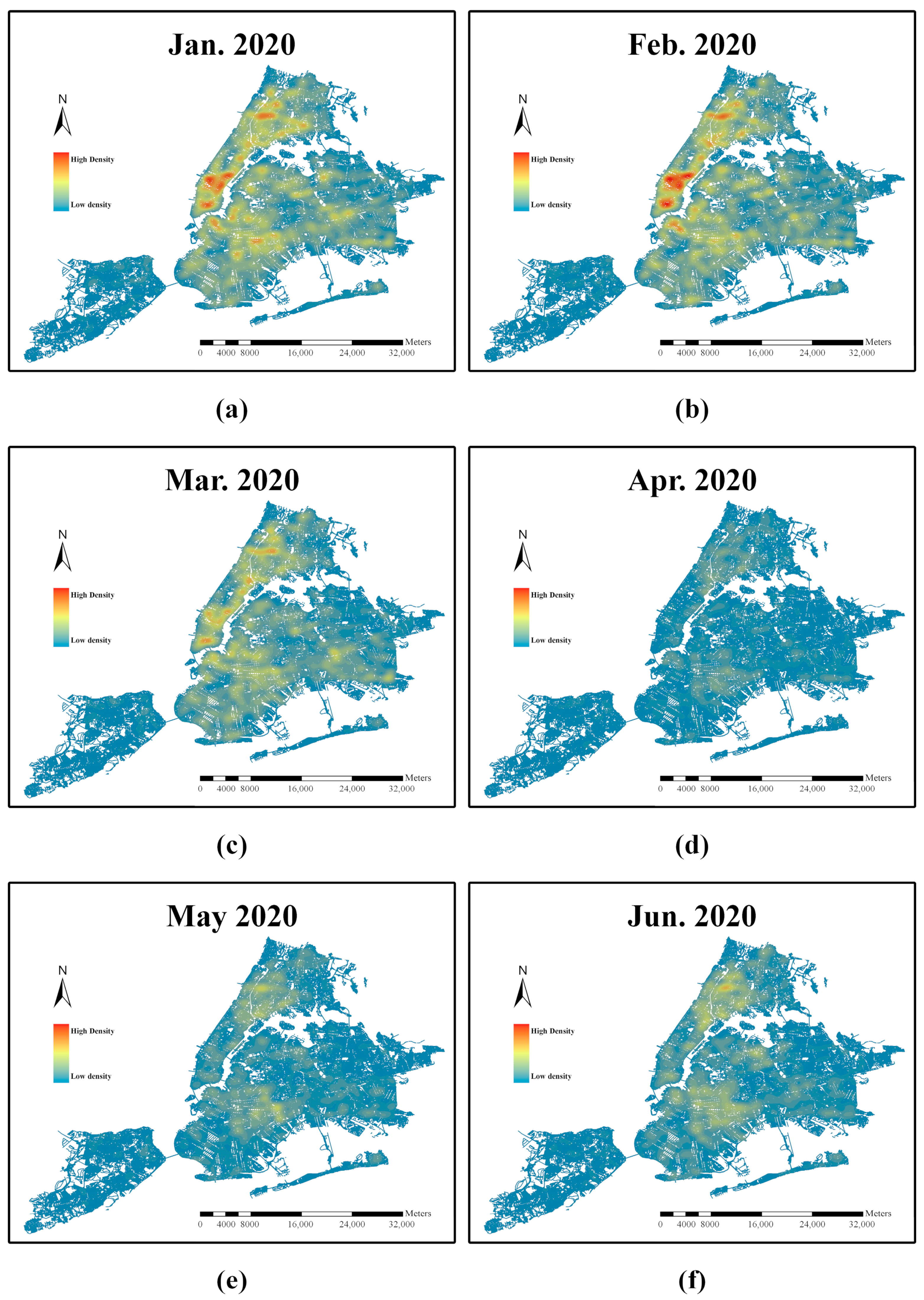
4.2. The Influence of the COVID-19 Pandemic on Urban Traffic Accidents

Based on the relevant data provided by OpenStreetMap [59], we processed the functional zoning of land use in New York City (Figure 2) to analyze the relationship between the travel behavior of residents and the spatial distribution characteristics of urban traffic accident hotspots.
First, we compared the differences in traffic accident hotspots and numbers before and during the pandemic (Figure 3 and Figure 4). Compared to the pre-pandemic period, the spatial distribution of traffic accident hotspots in New York City changed during the pandemic, and the number of traffic accidents in Manhattan decreased significantly. From Figure 5, we can see that the spatial distribution of traffic-accident-prone areas in New York City also changed compared to the pre-pandemic period. The high positive z-score and low p-value indicate significant clustering of high values. From the comparison of G*-statistics, we can observe that the spatial pattern before the pandemic was more pronounced. Using the hotspot analysis comparison tool in ArcGIS Pro, we compared the two hotspot analysis result layers before and during the pandemic, identified using the Getis-Ord Gi* method, and measured their similarity (Figure 6). The results showed that there are significant differences in the spatial patterns of hot and cold spots before and during the pandemic.
Then, we analyzed the spatial and temporal distribution characteristics of traffic-accident hotspots in New York City before and during the pandemic, with the year as the time dimension. As shown in Figure 7, the number of traffic accidents in New York City decreased significantly in 2020 and 2021 compared to the pre-pandemic period owing to the pandemic and related policy measures. As shown in Figure 7a–d, before the pandemic, traffic accident hotspots in New York City were concentrated mainly in the borough of Manhattan. A comparison of Figure 7a–d with Figure 8 reveals that, during the pandemic, the percentage of people working from home increased significantly. This occurrence reduced residents’ demand for work-related commuting, resulting in the spatial distribution of traffic accident hotspots changing from the single-center spatial distribution to the multi-center spatial distribution. As shown in Figure 9, the high positive z-score and low p-value indicate significant clustering of high values. From the comparison of G*-statistics, we can observe that the spatial pattern in 2016 was more pronounced. Combined with land use type, Figure 9a–d illustrate that, before the pandemic, the purpose of residents’ travel behavior was mainly for work, leading to more traffic accidents occurring in the central business district, traffic-accident-prone areas were predominantly distributed in the central business district of New York City and its surrounding residential areas. During the pandemic, the spread of the epidemic changed residents’ working patterns to some extent and the composition structure of the purpose of residents’ travel behavior and substantially impacted the spatiotemporal distribution characteristics of urban traffic accidents, which changed from a predominantly work-oriented focus before the pandemic to a work–life orientation during the pandemic. After the start of the pandemic, traffic-accident-prone areas were distributed to a greater extent in public service areas in the northern and central regions of New York City (Figure 9e,f).
We analyzed the impact of weather factors on traffic accidents in the city (as shown in Figure 10, Figure 11, Figure 12 and Figure 13). Considering the influence of the pandemic, we investigated the spatial distribution of traffic accident hotspots in different months before and during the pandemic. As shown in Figure 10, weather factors significantly affected traffic accidents in New York City before the pandemic. When the weather was cold, the number of traffic accidents was low and most pronounced in January (Figure 10a). During warm weather, the number of traffic accidents was relatively high, with the number in May being the most pronounced (Figure 10e). These results indicate that weather conditions affect residents’ travel to a certain extent and have a certain impact on traffic accidents. As shown in Figure 11 and Figure 13, the high positive z-score and low p-value indicate significant clustering of high values. From the comparison of G*-statistics, we can observe that the spatial patterns in February and February 2020 were more pronounced. In terms of land use type, before the pandemic, areas prone to traffic accidents were predominantly distributed in the central business district of New York City (Figure 11). A comparison of Figure 12 and Figure 13 indicates that, compared with weather factors, the pandemic and consequent policy measures, such as stay-at-home orders, had a more significant impact on traffic accidents. In January, the number of traffic accidents in the pre-pandemic period was relatively low, whereas the number of traffic accidents in the pandemic period was relatively high (Figure 10a with Figure 12a). In May, the number of traffic accidents in the pre-pandemic period was relatively high, whereas the number of traffic accidents in the pandemic period was relatively low (Figure 10e with Figure 12e). As shown in Figure 12, the number of traffic accidents in New York City was lowest in April 2020, indicating that the city’s stay-at-home order implemented in March 2020 significantly curbed residents’ mobility. Combined with Figure 1, a surge in the percentage of people staying at home and working from home is visible; the number of miles and trips per person decreased significantly immediately following the stay-at-home order, resulting in a decrease in traffic flow, which in turn reduced the number of traffic accidents. As shown in Figure 13, under the dual influence of the pandemic and government control, residents’ working pattern was reshaped, with an increase in the proportion of residents working from home, leading to a significant change in the composition structure of the purpose of residents’ travel behavior; thus, traffic-accident-prone areas shifted from the central business district to the public service areas in the northern and central regions of New York City. The most notable period of change was April 2020 (Figure 13d). This phenomenon reflects that changes in the composition structure of the purpose of residents’ travel behavior will affect the spatial distribution of traffic-accident-prone areas.

5. Discussion

In this study, based on multi-source data, we investigated the spatiotemporal distribution of urban traffic accident hotspots before and during the COVID-19 pandemic and the internal mechanisms of their changes. We studied the impact of residents’ mobility and residents’ travel behavior on the spatiotemporal distribution characteristics of urban traffic accident hotspots under the impact of the pandemic and the subsequent stay-at-home order. This paper contributes to the in-depth understanding of the spatiotemporal distribution characteristics of traffic accident hotspots and their intrinsic mechanism from the urban level.
Based on resident mobility, traffic flow, and traffic accident data, we investigated the intrinsic associations between the COVID-19 pandemic, the stay-at-home order, residents’ mobility, and traffic accidents. According to our findings, the pandemic and the stay-at-home order significantly curbed the mobility of residents. The percentage of residents staying at home and working from home increased significantly, whereas the number of miles per person, trips per person, work trips per person, and non-work trips per person decreased significantly. Our study revealed that as the pandemic was brought under control, and the stay-at-home order was relaxed, the proportion of people staying at home and the number of miles per person, trips per person, and non-work trips per person slowly returned to the levels before the stay-at-home order, whereas the proportion of people working from home and the number of work trips per person were sustained at elevated and decreased levels, respectively. This finding demonstrates that the pandemic has reshaped residents’ working patterns to a significant extent, leading to an increase in the proportion of residents working from home. The study on traffic flow in New York City also confirmed this finding. During the pandemic, the decrease in traffic flow in Manhattan was significantly higher than that of the overall traffic flow in New York, indicating that the rise in the number of residents working from home significantly reduced residents’ work-oriented travel requirements, resulting in a significant decline in traffic flow related to the central business district. The results show that the inhibition of residents’ mobility from the COVID-19 pandemic and stay-at-home order had a significant impact on the spatial distribution of traffic accident hotspots, with the urban traffic accident hotspots changing from the single-center spatial distribution before the pandemic to the multi-center spatial distribution during the pandemic. However, it is worth noting that the temporal/spatial patterns are not identical for all types of accidents. Krukowicz et al. [60] found no impact on animal–vehicle crashes during the lockdown in the initial period of the COVID-19 pandemic (March–April 2020).
Based on land use functional zoning obtained by processing and traffic accident data, we investigated the intrinsic associations between the COVID-19 pandemic, the stay-at-home order, residents’ travel behavior, and traffic accidents. The research results indicate that the pandemic and the stay-at-home order had a significant impact on residents’ travel behavior, and the composition structure of the purpose of residents’ travel behavior changed significantly. The change in the composition structure of the purpose of residents’ travel behavior affected the spatial distribution of traffic-accident-prone areas; urban traffic-accident-prone areas changed from being mainly distributed in the central business district before the pandemic to being more widely distributed in public service areas during the pandemic, indicating that the travel behavior of residents changes the spatial distribution of urban traffic accident hotspots to a certain extent. We believe that the results of this study may add insight into the impact of residents’ mobility and residents’ travel behavior on the spatiotemporal distribution characteristics of urban traffic accident hotspots and its internal mechanism under the impact of the pandemic and the subsequent stay-at-home order; it may also provide additional insight into the goal of achieving Vision Zero for traffic accidents through policy measures. This study also has several limitations. Due to the limitation of data availability, we only studied traffic accidents in New York City, so the study area can be expanded to other cities and countries in the future. In addition, the current study takes motor vehicles as the research object. In the future, research objects can be expanded to pedestrians, bicycles, and motorcycles.

Author Contributions

Conceptualization, Y.C., L.W. and H.Z.; methodology, Y.C., L.W. and H.Z.; software, H.Z. and Y.H.; validation, Y.C. and L.W.; formal analysis, H.Z.; investigation, Y.C., L.W. and H.Z.; resources, Y.C., L.W. and H.Z.; data curation, H.Z. and Y.H.; writing—original draft preparation, H.Z.; writing—review and editing, Y.C. and L.W.; visualization, H.Z. and Y.H.; supervision, Y.C. and L.W.; project administration, H.Z.; funding acquisition, Y.C. All authors have read and agreed to the published version of the manuscript.

Funding

This research was funded by the National Key R & D Program of China (Grant No. 2021YFB2600502).

Institutional Review Board Statement

Not applicable.

Informed Consent Statement

Not applicable.

Data Availability Statement

The data presented in this study are available upon request from the corresponding author.

Conflicts of Interest

The authors declare no conflicts of interest.

References

  1. Global Status Report on Road Safety 2018. 2018. Available online: https://www.who.int/publications/i/item/9789241565684 (accessed on 12 January 2024).
  2. Abdel-Aty, M.A.; Radwan, A.E. Modeling traffic accident occurrence and involvement. Accid. Anal. Prev. 2000, 32, 633–642. [Google Scholar] [CrossRef] [PubMed]
  3. Singh, H.; Kathuria, A. Analyzing driver behavior under naturalistic driving conditions: A review. Accid. Anal. Prev. 2021, 150, 105908. [Google Scholar] [CrossRef] [PubMed]
  4. Wang, C.; Xie, Y.; Huang, H.; Liu, P. A review of surrogate safety measures and their applications in connected and automated vehicles safety modeling. Accid. Anal. Prev. 2021, 157, 106157. [Google Scholar] [CrossRef]
  5. Arun, A.; Haque, M.M.; Bhaskar, A.; Washington, S.; Sayed, T. A systematic mapping review of surrogate safety assessment using traffic conflict techniques. Accid. Anal. Prev. 2021, 153, 106016. [Google Scholar] [CrossRef] [PubMed]
  6. Zheng, L.; Sayed, T.; Mannering, F. Modeling traffic conflicts for use in road safety analysis: A review of analytic methods and future directions. Anal. Methods Accid. Res. 2021, 29, 100142. [Google Scholar] [CrossRef]
  7. Rosenthal, D.M.; Heys, M.; Schoenthaler, A.; Hayward, A.; Ucci, M.; Lewis, C. How did living in temporary accommodation during the COVID-19 pandemic affect children younger than 5 years’ access to health care and health outcomes? A qualitative study of key professionals in a socially and ethnically diverse and deprived area of London. Lancet 2022, 400, S75. [Google Scholar] [CrossRef] [PubMed]
  8. Shew, A. Let COVID-19 expand awareness of disability tech. Nature 2020, 581, 9–10. [Google Scholar] [CrossRef] [PubMed]
  9. Harirforoush, H.; Bellalite, L. A new integrated GIS-based analysis to detect hotspots: A case study of the city of Sherbrooke. Accid. Anal. Prev. 2019, 130, 62–74. [Google Scholar] [CrossRef] [PubMed]
  10. Sarkar, C.; Webster, C.; Kumari, S. Street morphology and severity of road casualties: A 5-year study of Greater London. Int. J. Sustain. Transp. 2018, 12, 510–525. [Google Scholar] [CrossRef]
  11. Dagaeva, M.; Garaeva, A.; Anikin, I.; Makhmutova, A.; Minnikhanov, R. Big spatio-temporal data mining for emergency management information systems. IET Intell. Transp. Syst. 2019, 13, 1649–1657. [Google Scholar] [CrossRef]
  12. Zhang, W.; Liu, T.; Yi, J. Exploring the spatiotemporal characteristics and causes of rear-end collisions on urban roadways. Sustainability 2022, 14, 11761. [Google Scholar] [CrossRef]
  13. Levine, N.; Ceccato, V. Malignant mixes: The overlap of motor vehicle crashes and crime in Stockholm, Sweden. Accid. Anal. Prev. 2021, 161, 106361. [Google Scholar] [CrossRef] [PubMed]
  14. Kazmi, S.S.A.; Ahmed, M.; Mumtaz, R.; Anwar, Z. Spatiotemporal clustering and analysis of road accident hotspots by exploiting GIS technology and Kernel density estimation. Comput. J. 2022, 65, 155–176. [Google Scholar] [CrossRef]
  15. Kavousi, A.; Moradi, A.; Rahmani, K.; Zeini, S.; Ameri, P. Geographical distribution of at fault drivers involved in fatal traffic collisions in Tehran, Iran. Epidemiol. Health 2020, 42, e2020002. [Google Scholar] [CrossRef] [PubMed]
  16. Le, K.G.; Liu, P.; Lin, L.T. Traffic accident hotspot identification by integrating kernel density estimation and spatial autocorrelation analysis: A case study. Int. J. Crashworthiness 2022, 27, 543–553. [Google Scholar] [CrossRef]
  17. Almoshaogeh, M.; Abdulrehman, R.; Haider, H.; Alharbi, F.; Jamal, A.; Alarifi, S.; Shafiquzzaman, M.D. Traffic accident risk assessment framework for qassim, saudi arabia: Evaluating the impact of speed cameras. Appl. Sci. 2021, 11, 6682. [Google Scholar] [CrossRef]
  18. Erdoğan, S.; Dereli, M.A.; Şenol, H.İ. A GIS-based assessment of long-term traffic accidents using spatiotemporal and empirical Bayes analysis in Turkey. Appl. Geomat. 2022, 14, 147–162. [Google Scholar] [CrossRef]
  19. Zhai, C.; Li, Z.; Jiang, F.; Ma, J.J.; Xu, Z. A spatial analysis methodology based on lazy ensembled adaptive associative classifier and GIS for examining the influential factors on traffic fatalities. IEEE Access 2020, 8, 117932–117945. [Google Scholar] [CrossRef]
  20. Umair, M.; Rana, I.A.; Lodhi, R.H. The impact of urban design and the built environment on road traffic crashes: A case study of Rawalpindi, Pakistan. Case Stud. Transp. Policy 2022, 10, 417–426. [Google Scholar] [CrossRef]
  21. Al-Aamri, A.K.; Hornby, G.; Zhang, L.C.; Al-Maniri, A.A.; Padmadas, S.S. Mapping road traffic crash hotspots using GIS-based methods: A case study of Muscat Governorate in the Sultanate of Oman. Spat. Stat. 2021, 42, 100458. [Google Scholar] [CrossRef]
  22. Mesquitela, J.; Elvas, L.B.; Ferreira, J.C.; Nunes, L. Data analytics process over road accidents data—A case study of Lisbon City. ISPRS Int. J. Geo-Inf. 2022, 11, 143. [Google Scholar] [CrossRef]
  23. Wang, M.; Yi, J.; Chen, X.; Zhang, W.; Qiang, T. Spatial and temporal distribution analysis of traffic accidents using GIS-based data in Harbin. J. Adv. Transp. 2021, 2021, 9207500. [Google Scholar] [CrossRef]
  24. Rahman, M.T.; Jamal, A.; Al-Ahmadi, H.M. Examining hotspots of traffic collisions and their spatial relationships with land use: A GIS-based geographically weighted regression approach for Dammam, Saudi Arabia. ISPRS Int. J. Geo-Inf. 2020, 9, 540. [Google Scholar] [CrossRef]
  25. Le, K.G.; Liu, P.; Lin, L.T. Determining the road traffic accident hotspots using GIS-based temporal-spatial statistical analytic techniques in Hanoi, Vietnam. Geo-Spat. Inf. Sci. 2020, 23, 153–164. [Google Scholar] [CrossRef]
  26. Lei, Y.; Ozbay, K.; Xie, K. Safety analytics at a granular level using a Gaussian process modulated renewal model: A case study of the COVID-19 pandemic. Accid. Anal. Prev. 2022, 173, 106715. [Google Scholar] [CrossRef]
  27. Ma, Y.; Xu, J.; Gao, C.; Tong, X. Impacts of COVID-19 travel restriction policies on the traffic quality of the national and provincial trunk highway network: A case study of Shaanxi Province. Int. J. Environ. Res. Public Health 2022, 19, 9387. [Google Scholar] [CrossRef]
  28. Vingilis, E.; Beirness, D.; Boase, P.; Byrne, P.; Johnson, J.; Jonah, B.; Mann, R.E.; Rapoport, M.J.; Seeley, J.; Wickens, C.M.; et al. Coronavirus disease 2019: What could be the effects on road safety? Accid. Anal. Prev. 2020, 144, 105687. [Google Scholar] [CrossRef]
  29. Rad, M.F.; El-Basyouny, K. How COVID-19 impacted the temporal and spatial distribution of collision hotspots. Can. J. Civ. Eng. 2024, 1–24. [Google Scholar] [CrossRef]
  30. Lin, L.; Shi, F.; Li, W. Assessing inequality, irregularity, and severity regarding road traffic safety during COVID-19. Sci. Rep. 2021, 11, 13147. [Google Scholar] [CrossRef] [PubMed]
  31. Muley, D.; Ghanim, M.S.; Mohammad, A.; Kharbeche, M. Quantifying the impact of COVID–19 preventive measures on traffic in the State of Qatar. Transp. Policy 2021, 103, 45–59. [Google Scholar] [CrossRef]
  32. Cappellari, P.; Weber, B.S. An analysis of the New York City traffic volume, vehicle collisions, and safety under COVID-19. J. Saf. Res. 2022, 83, 57–65. [Google Scholar] [CrossRef] [PubMed]
  33. Yasin, Y.J.; Grivna, M.; Abu-Zidan, F.M. Global impact of COVID-19 pandemic on road traffic collisions. World J. Emerg. Surg. 2021, 16, 51. [Google Scholar] [CrossRef]
  34. Wang, J.; Yang, X.; Yu, S.; Yuan, Q.; Lian, Z.; Yang, Q. Road crash risk prediction during COVID-19 for flash crowd traffic prevention: The case of Los Angeles. Comput. Commun. 2023, 198, 195–205. [Google Scholar] [CrossRef]
  35. Bajor, M. Wskaźniki BRD w Okresie Ograniczonej Mobilności. 2021. Available online: https://media-prof.pl/web/files/24448/PKD_MBajor_Analizy-BRD_2021_05_18.pdf (accessed on 11 March 2024).
  36. Doucette, M.L.; Tucker, A.; Auguste, M.E.; Watkins, A.; Green, C.; Pereira, F.E.; Borrup, K.T.; Shapiro, D.; Lapidus, G. Initial impact of COVID-19’s stay-at-home order on motor vehicle traffic and crash patterns in Connecticut: An interrupted time series analysis. Inj. Prev. 2021, 27, 3–9. [Google Scholar] [CrossRef]
  37. Islam, M.; Alogaili, A.; Mannering, F.; Maness, M. Evidence of sample selectivity in highway injury-severity models: The case of risky driving during COVID-19. Anal. Methods Accid. Res. 2023, 38, 100263. [Google Scholar] [CrossRef]
  38. Vanlaar, W.G.; Woods-Fry, H.; Barrett, H.; Lyon, C.; Brown, S.; Wicklund, C.; Robertson, R.D. The impact of COVID-19 on road safety in Canada and the United States. Accid. Anal. Prev. 2021, 160, 106324. [Google Scholar] [CrossRef] [PubMed]
  39. Adanu, E.K.; Brown, D.; Jones, S.; Parrish, A. How did the COVID-19 pandemic affect road crashes and crash outcomes in Alabama? Accid. Anal. Prev. 2021, 163, 106428. [Google Scholar] [CrossRef] [PubMed]
  40. Shahlaee, A.; Shirazi, M.; Marshall, E.; Ivan, J.N. Modeling the impact of the COVID-19 pandemic on speeding at rural roadway facilities in Maine using short-term speed and traffic count data. Accid. Anal. Prev. 2022, 177, 106828. [Google Scholar] [CrossRef]
  41. Al-Hussein, W.A.; Li, W.; Por, L.Y.; Ku, C.S.; Alredany, W.H.D.; Leesri, T.; MohamadJawad, H.H. Investigating the effect of COVID-19 on driver behavior and road safety: A naturalistic driving study in Malaysia. Int. J. Environ. Res. Public Health 2022, 19, 11224. [Google Scholar] [CrossRef]
  42. Dong, X.; Xie, K.; Yang, H. How did COVID-19 impact driving behaviors and crash Severity? A multigroup structural equation modeling. Accid. Anal. Prev. 2022, 172, 106687. [Google Scholar] [CrossRef]
  43. Patwary, A.L.; Khattak, A.J. Crash harm before and during the COVID-19 pandemic: Evidence for spatial heterogeneity in Tennessee. Accid. Anal. Prev. 2023, 183, 106988. [Google Scholar] [CrossRef] [PubMed]
  44. University of Maryland COVID-19 Impact Analysis Planform. 2020. Available online:https://data.covid.umd.edu (accessed on 22 October 2023).
  45. Zhang, L.; Darzi, A.; Ghader, S.; Pack, M.L.; Xiong, C.; Yang, M.; Sun, Q.; Kabiri, A.; Hu, S. Interactive COVID-19 mobility impact and social distancing analysis platform. Transp. Res. Rec. 2021, 2677, 168–180. [Google Scholar] [CrossRef] [PubMed]
  46. Hourly Traffic on Metropolitan Transportation Authority (MTA) Bridges and Tunnels. 2020. Available online:https://data.ny.gov/Transportation/Hourly-Traffic-on-Metropolitan-Transportation-Auth/qzve-kjga (accessed on 22 October 2023).
  47. Motor Vehicle Collisions–Crashes. 2022. Available online:https://data.cityofnewyork.us/Public-Safety/Motor-Vehicle-Collisions-Crashes/h9gi-nx95 (accessed on 16 November 2023).
  48. Esri. ArcGIS Pro (3.2); Environmental Systems Research Institute: Redlands, CA, USA, 2023. [Google Scholar]
  49. Al-Ruzouq, R.; Hamad, K.; Abu Dabous, S.; Zeiada, W.; Khalil, M.A.; Voigt, T. Weighted multi-attribute framework to identify freeway incident hot spots in a spatiotemporal context. Arab. J. Sci. Eng. 2019, 44, 8205–8223. [Google Scholar] [CrossRef]
  50. Özcan, M.; Küçükönder, M. Investigation of spatiotemporal changes in the incidence of traffic accidents in Kahramanmaraş, Turkey, using GIS-based density analysis. J. Indian Soc. Remote Sens. 2020, 48, 1045–1056. [Google Scholar] [CrossRef]
  51. Yalcin, G.; Duzgun, H.S. Spatial analysis of two-wheeled vehicles traffic crashes: Osmaniye in Turkey. KSCE J. Civ. Eng. 2015, 19, 2225–2232. [Google Scholar] [CrossRef]
  52. Porter, M.D.; Reich, B.J. Evaluating temporally weighted kernel density methods for predicting the next event location in a series. Ann. GIS 2012, 18, 225–240. [Google Scholar] [CrossRef]
  53. Silverman, B.W. Density Estimation for Statistics and Data Analysis; CRC Press: Boca Raton, FL, USA, 1986. [Google Scholar]
  54. Ushakov, N.G.; Ushakov, V.G. On bandwidth selection in kernel density estimation. J. Nonparametric Stat. 2012, 24, 419–428. [Google Scholar] [CrossRef]
  55. Getis, A.; Ord, J.K. The analysis of spatial association by use of distance statistics. Geogr. Anal. 1992, 24, 189–206. [Google Scholar] [CrossRef]
  56. Anacker, K.B. US suburbs and the lobal COVID-19 pandemic: From cleanscapes to safescapes 2.0? The case of the New York metropolitan area. Urban Geogr. 2022, 43, 1260–1267. [Google Scholar] [CrossRef]
  57. Kavikondala, S.M.; Sperling, J.; Hou, Y.; Holden, J.; Young, S.; Duvall, A.; Yang, A. Quantifying movement motivations, demand, and inflow-outflow dynamics in four cities (New York, Chicago, Austin, and San Diego) during COVID-19. In Proceedings of the International Conference on Transportation and Development 2022, Seattle, WA, USA, 31 May–3 June 2022; pp. 133–141. [Google Scholar] [CrossRef]
  58. Ravenelle, A.J.; Conley, J.; Newell, A. Left behind: Yachts, dinghies, and perceptions of social inequality in COVID-19. Sociol. Q. 2023, 64, 367–386. [Google Scholar] [CrossRef]
  59. OpenStreetMap. 2022. Available online: https://www.openstreetmap.org/copyright/en (accessed on 21 November 2023).
  60. Krukowicz, T.; Firląg, K.; Chrobot, P. Spatiotemporal analysis of road crashes with animals in Poland. Sustainability 2022, 14, 1253. [Google Scholar] [CrossRef]
Figure 1. Changes in resident mobility during the COVID-19 pandemic: (a) staying home; (b) working from home; (c) trips/person; (d) miles/person; (e) work trips/person; (f) non-work trips/person.
Sustainability 16 03440 g001
Figure 2. Land use functional zoning in New York City.
Sustainability 16 03440 g002
Figure 3. Traffic accident hotspots in New York City: (a) before the pandemic; (b) during the pandemic.
Sustainability 16 03440 g003
Figure 4. Differential map of the number of traffic accidents in New York City before and during the pandemic.
Sustainability 16 03440 g004
Figure 5. Spatial distribution of traffic accident cold and hot spots in New York City: (a) before the pandemic; (b) during the pandemic.
Sustainability 16 03440 g005
Figure 6. Difference comparison map of traffic accident cold and hot spots in New York City before and during the pandemic.
Sustainability 16 03440 g006
Figure 7. Traffic accident hotspots in New York City, 2016–2021: (a) 2016; (b) 2017; (c) 2018; (d) 2019; (e) 2020; (f) 2021.
Sustainability 16 03440 g007
Figure 8. Enlarged view of traffic accident hotspots in New York City, 2020–2021: (a) 2020; (b) 2021.
Sustainability 16 03440 g008
Figure 9. Spatial distribution of traffic accident cold and hot spots in New York City, 2016–2021: (a) 2016; (b) 2017; (c) 2018; (d) 2019; (e) 2020; (f) 2021.
Sustainability 16 03440 g009
Figure 10. Monthly variation map of traffic accident hotspots in New York City before the pandemic, 2016–2019: (a) January; (b) February; (c) March; (d) April; (e) May; (f) June.
Sustainability 16 03440 g010
Figure 11. Monthly variation map of the spatial distribution of traffic accident cold and hot spots in New York City before the pandemic, 2016–2019: (a) January; (b) February; (c) March; (d) April; (e) May; (f) June.
Sustainability 16 03440 g011
Figure 12. Monthly variation map of traffic accident hotspots in New York City during the pandemic, 2020: (a) January 2020; (b) February 2020; (c) March 2020; (d) April 2020; (e) May 2020; (f) June 2020.
Sustainability 16 03440 g012
Figure 13. Monthly variation map of the spatial distribution of traffic accident cold and hot spots in New York City during the pandemic, 2020: (a) January 2020; (b) February 2020; (c) March 2020; (d) April 2020; (e) May 2020; (f) June 2020.
Sustainability 16 03440 g013
Disclaimer/Publisher’s Note: The statements, opinions and data contained in all publications are solely those of the individual author(s) and contributor(s) and not of MDPI and/or the editor(s). MDPI and/or the editor(s) disclaim responsibility for any injury to people or property resulting from any ideas, methods, instructions or products referred to in the content.

