Article

Terraced Landscapes and Hydrogeological Risk. Effects of Land Abandonment in Cinque Terre (Italy) during Severe Rainfall Events

Department of Agricultural, Food and Forest Systems Management (GESAAF), University of Florence, Via San Bonaventura 13, 50145 Firenze, Italy
*
Author to whom correspondence should be addressed.
Sustainability 2019, 11(1), 235; https://doi.org/10.3390/su11010235
Submission received: 30 November 2018 / Revised: 21 December 2018 / Accepted: 28 December 2018 / Published: 4 January 2019

Abstract

:
During 25 October 2011, an extremely intense rainfall event occurred in Eastern Liguria and Northern Tuscany. Severe damages were registered in the Monterosso and Vernazza basins, located in the famous area of Cinque Terre, which have been affected by hundreds of landslides, mud flows, and erosions. The main feature of the Cinque Terre landscape is the presence of terraced cultivations on steep slopes facing the sea. The area represents a remarkable cultural landscape, is a National Park, and is included in the World Heritage List of the UNESCO. This work aims to analyze the effect of abandoned terraced land on hydrogeological risks and in landslide prevention, by comparing what happened in Cinque Terre to other experiences presented in scientific literature. The cessation of maintenance of dry stone terraces due to the crisis of traditional agriculture was identified as the main cause of failure during the heavy rainfall event. However, we found some contrasting and, in some cases, unexpected results in the literature regarding the effects of the vegetation that develops on abandoned terraces. This paper compares different results in order to better understand what the future of terraced landscapes is and which are the best management strategies for such complex and fragile territories. In particular, where they represent a cultural heritage and a resource for the rural economy.

1. Introduction

The existence and importance of terracing in Italy is attested ever since the Neolithic Age and is well documented from the Middle Ages onward. Contour terraces and regular terraces remained in use until the second postwar period, because sharecropper contracts guaranteed their constant maintenance. Terraces were thus a regular feature of many hill and mountain landscapes in Italy, as well as in many southern European countries.
Italian agriculture has suffered a progressive decline that began 60 years ago. This phenomena has been even more evident in terraced landscapes, since they are less convenient and less remunerative to cultivate. The abandonment of cultivated terraces affected many other countries, especially in Europe [1,2,3,4,5,6]. Although they have a historical and aesthetic significance, and are a resource for agriculture and tourism, they are also a challenge for land conservation and management [7,8].
Among the ecosystem services that terraced landscapes can provide, the reduction of hydrogeological risk is probably one of the most important. The role of terracing in the hydrologic behavior of slopes has become a topic of interest, especially in Mediterranean areas [9,10,11,12,13,14], as they constitute a system that strongly modifies runoff processes on steep slopes [15,16,17], erosion [13], and infiltration [10]. The study of terracing has gained special importance over the last years with the growth of awareness of their economic, environmental, and cultural-historical importance, as well as of the hydrological functions of terraced landscapes in farm areas, including erosion control, slope stabilization, lengthening of concentration times, and reduction of surface runoff [4,12,13,18]. These kind of traditional agricultural landscapes are today not only included in the UNESCO Cultural landscapes but represents the main focus of the Globally Important Agricultural Heritage Systems program of the FAO.
The first consequence of terrace abandonment is the occurrence of degradation processes such as erosion and mass movements, due to an initial increase in hydrological connectivity and the degradation of risers [3,5,6,19,20]. Furthermore, recent studies highlighted how colonization of slopes by woods goes together with the deterioration of terraces, both as cause and effect [21]. This consequently leads to an increase of erosion and landslide risks. On the other hand, the growth of more complex vegetation canopies gives an increasing stability to slopes over time, due to root reinforcement and erosion control [22,23,24,25].
In central Italy, abandoned terraces are becoming a serious hazard because of their uphill proximity to human settlements. For this reason, several studies have already been carried out in the Tuscany and Liguria regions [14,26,27,28,29,30]. Investigations by Agnoletti et al. [31], highlighted certain aspects of the relationship between terracing and hydrogeological risk. As regards the hydrogeological aspect, terrace abandonment resulted in a process of erosion and shallow instability. Other studies in the Apuan Alps area [18] highlighted the relationship between the abandonment of terraces and landscape dynamics and the decrease of biodiversity, with the consequences of the hydrogeological disasters that occurred in the Cardoso basin in 1996.
The aim of this paper is to analyze the role of agricultural terraces in terms of landslide prevention and soil protection, comparing results from a survey of the landslides carried out immediately after the 25 October 2011 rainstorm in Cinque Terre, with other scientific studies carried out in other terraced areas of the world.

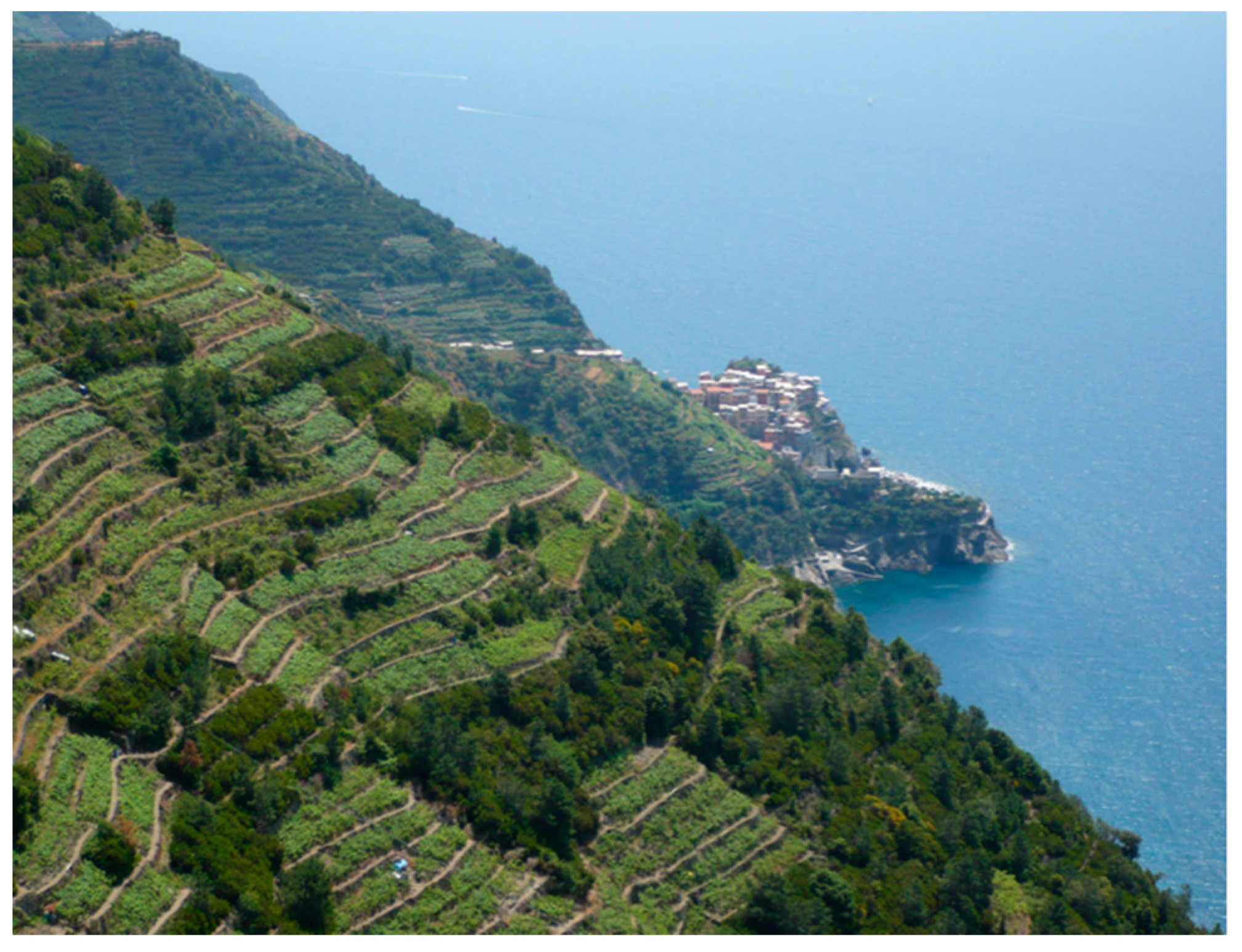
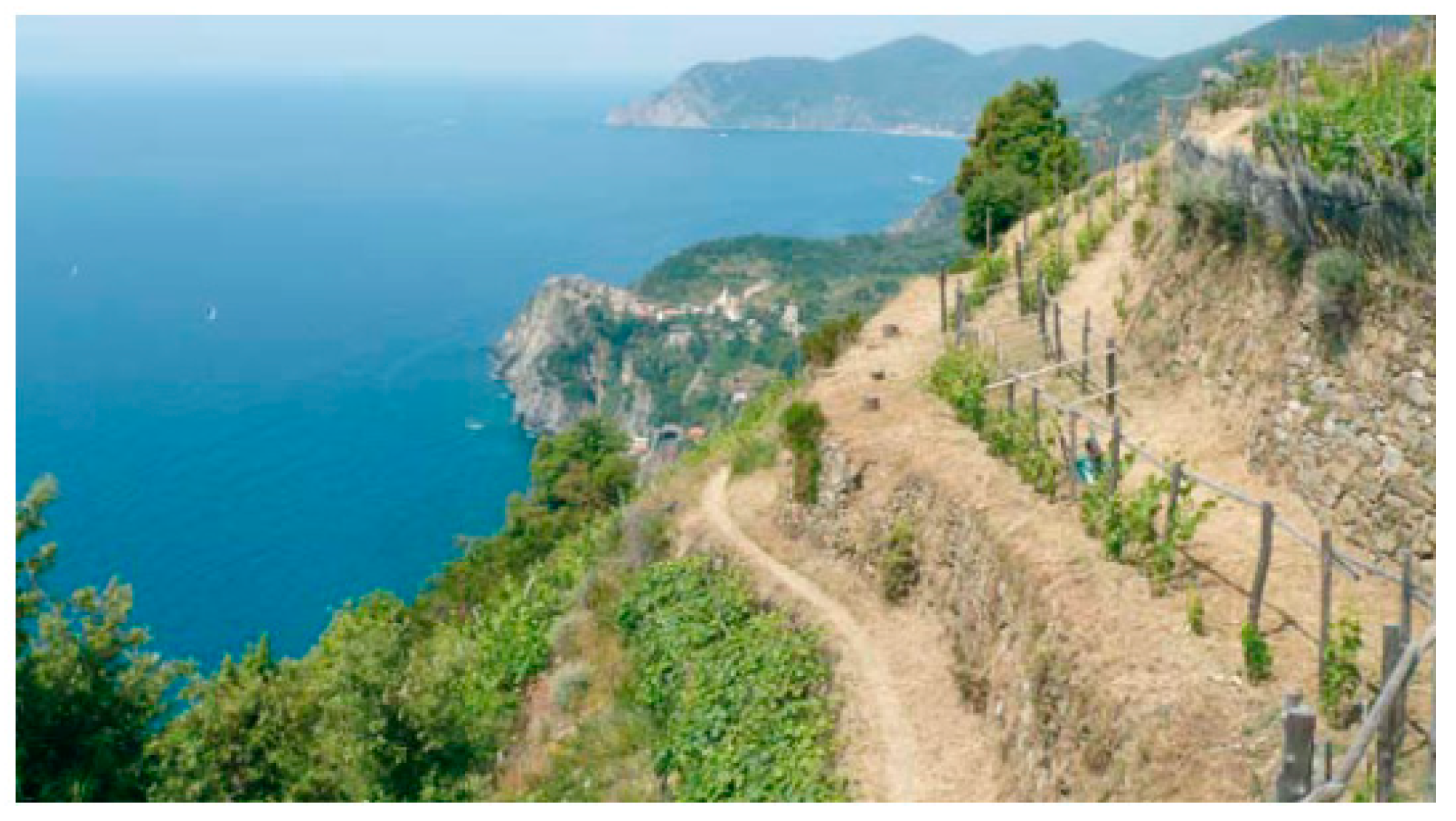
History of Cinque Terre and Its Viticulture

According to available historical sources, in pre-Roman times the Cinque Terre area was peopled partly by Liguri, Apuani and partly by Tigulli. There are divergent testimonies about the first building of terraces. For example, the bronze tablet known as the Polcevera Table (117 BC) reports that the ancient Liguri were already growing grapes and building contour terraces in pre-Roman times. Pliny the Elder celebrates the vinum lunense and mentions its presence in the Maritime Alps of a wild grape known as raetica. What is certain is that the historical terraced landscape of Cinque Terre is the result of major transformations undertaken by human beings over 1000 years of history, through the harsh, continuous, and assiduous toil of generations who over centuries replaced the shrublands and woods covering the slopes with vineyards growing on terraces [32].
After the early Middle Ages, which witnessed a barbarization of farming practices, the first timid signs of a recovery begin to be noticeable around the year 1000. Lands that had been abandoned for a long time, or devastated by the violence of Saracen incursions, were farmed again, leaving ample room for grapevines. Historical documents indicate that Cinque Terre also witnessed a new bloom around the year 1000. This is when the famous five towns were founded, and the first agricultural landscaping works undertaken. It is also around this time that terracing became widespread, thanks to the control of the land exercised by Benedictine monasteries and parishes. “The local people were charged with farm work in exchange for protection. Deforestation, valley-bottom hydraulic works, the opening up of some mountain paths, and the spread of terracing and olive-growing contributed to redefine the organization and image of the landscape, notwithstanding interruptions and slowdowns due to Saracen invasions until the eleventh century” [33]. Three main forms of terraces were built—contour terraces, lunettes, and terraces in the strict sense. The first type was used in the interior of Liguria, where slopes are not excessively steep (along ridges or valley bottoms). Vegetables were usually grown on the terraces and they were retained by short grassy scarps. The second type, especially popular in the Middle Ages, was used to prevent the land in which individual trees are rooted from being washed away. These terraces had crescent-shaped dry-stone walls and were built on steep slopes. Terraces in the strict sense, instead, consist of a succession of dry-stone walls that retain the cultivable plots, which are more or less wide, depending on the inclination of the slope. Usually the stones of the terrace walls are laid without a binder to allow excess water to drain away. Thus, the harsh toil that made the land cultivable gave rise to a “stepped land” [34].
The first descriptions of Cinque Terre date from the early fourteenth century. Jacopo Bracelli, chancellor and historiographer of the Genoese Republic was the first to provide a fairly accurate description of this area of Liguria, in his Descriptio orae Ligusticae (1448). “Then along the coast stand five lands almost at equal distances from one another, which are Monterosso, Vulnezia, now vulgarly known as Vernazza, Cornelia, Manarola and Rio Maggiore, famous not only in Italy but also among the French and the English for the excellence of their wine”. These five towns were spontaneously associated under a single name, both because of the quality of their wine and because they all grew grapes in the same way, on terraces that left a strong mark on their landscape and sharply distinguished it from the rest of the extreme versant of Liguria. Thanks to the foundation of these municipalities and the cessation of the incursions of Saracen pirates, both the settlements and the crops began to expand along the coast and inland. The terraces became a collective resource to be defended, as attested by prescriptions in municipal statutes, such as the one of Celle in 1414, forbidding the taking of stones from terrace walls or the tilling of the soil too close to the walls at risk of damaging them.
The year 1874 witnessed the publication of the Guida delle Alpi Apuane, edited by Cesare Zolfanelli and Vincenzo Santini, which offers an accurate and detailed description of Cinque Terre. “From Portovenere, following the coastline railway towards Genoa, one encounters the cove of Cinque Terre (…) and there are some extremely patient farmers who, so as not lose the advantage of their experience, plant vineyards on slopes of bare rock. Having built a low wall, they bring soil from other places; but sometimes misfortune hits them, and the industrious grower sees the whole thing washed down to sea by the water.”
In 1920, local viticulture had been seriously impacted by Phylloxera, which in very few years caused the death of all varieties of grapes grown in the area. After the Phylloxera epidemic, viticulture had a hard time recovering, partly due to the lack of labor. As early as the late nineteenth century, as agricultural income decreased, the first migratory flows began, first towards cities, then towards foreign countries, especially the Americas.
From the 1970s onward (Figure 1), Cinque Terre witnessed a more than 70% decline of its agriculture and fishing. The towns of Vernazza and Riomaggiore were those that experienced the worst decline of viticulture; for example, the loss of over 52 ha was reported in Riomaggiore between 1982 and 1990, and 24 ha in Vernazza [35]. This decrease of vineyard surface can be regarded as a constant trend over the last thirty years. The depopulation of the countryside has determined a constant reduction of the maintenance required by the terraces. Terraced viticulture in the Cinque Terre area is an economic, historical, and cultural heritage, a landscape modeled by human beings with the sweat of their brow to guarantee their livelihood. But if the population declines, this heritage is placed in jeopardy.

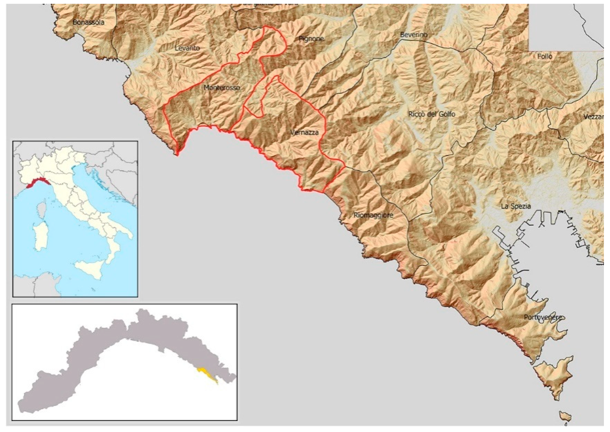
2. Materials and Methods

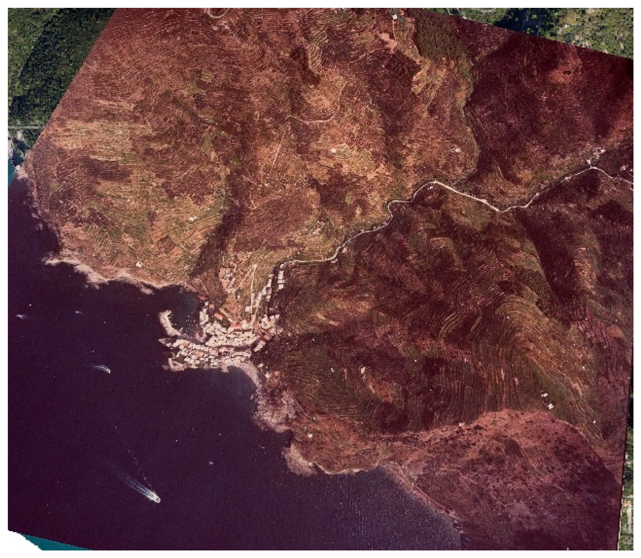
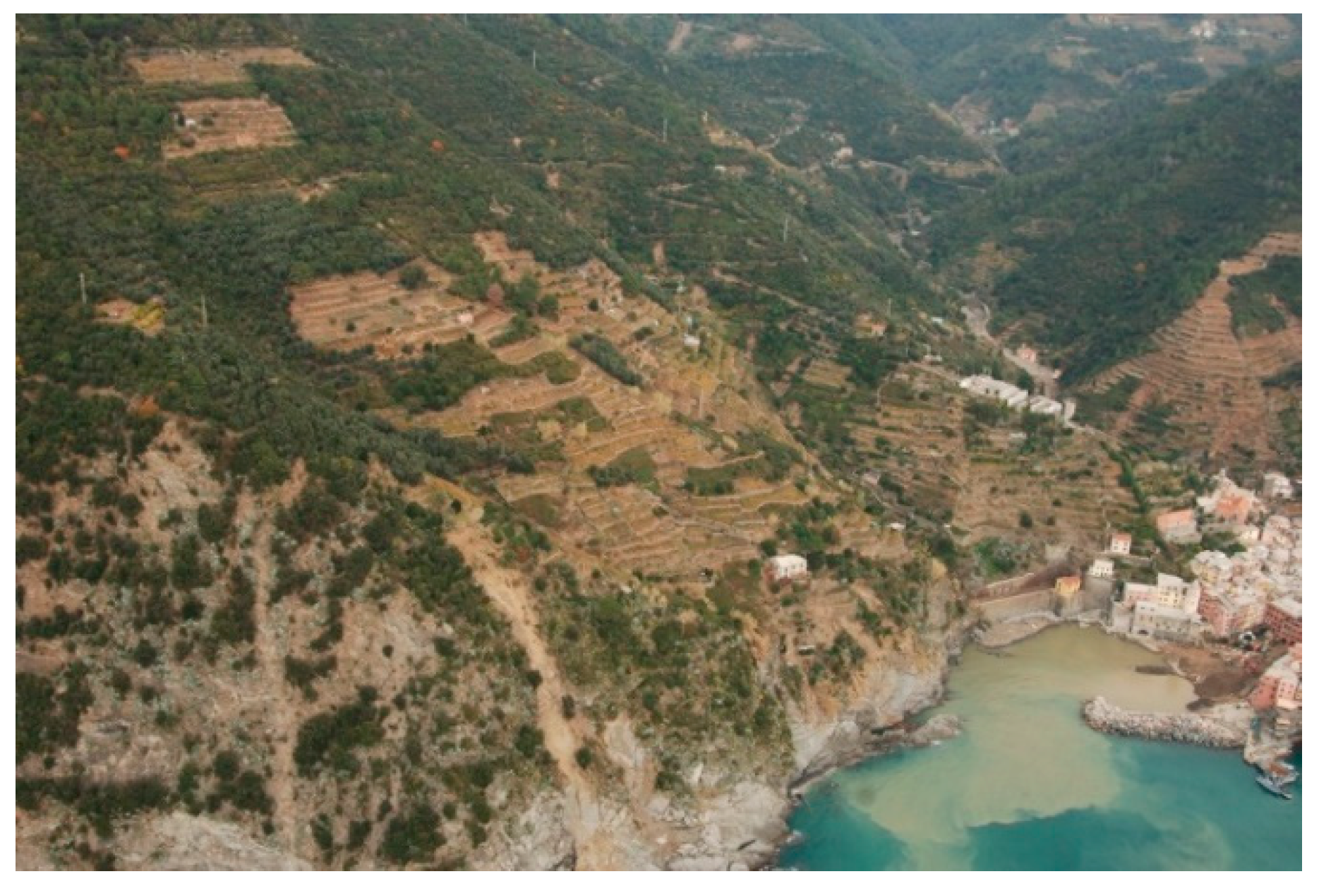
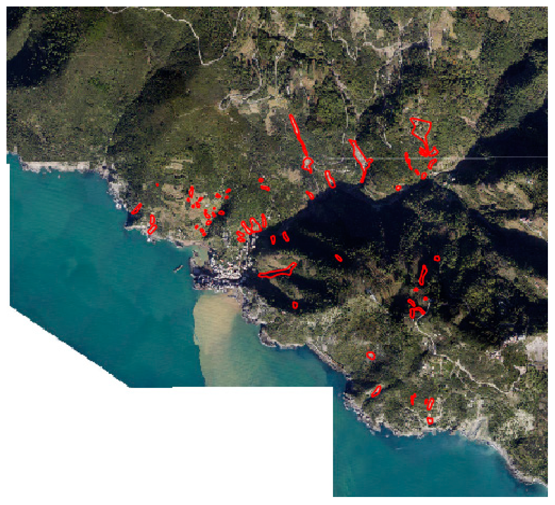
The Cinque Terre and the 25 October 2011 Rainstorm
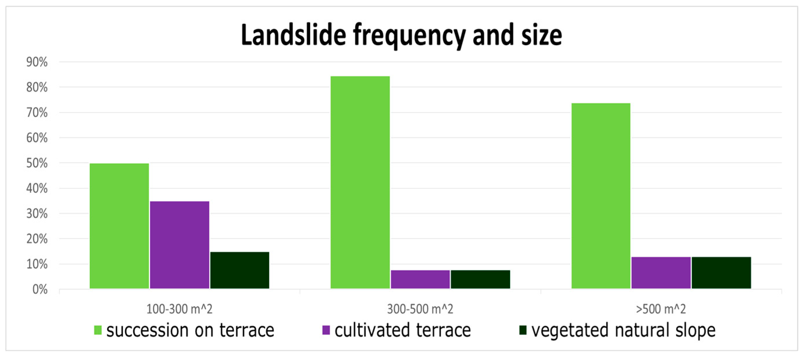
The Cinque Terre area is located along the coast of Liguria Region, in Northeastern Italy (Figure 2), and owes its importance not only to its productive viticulture, but also because it is part of a National Park and of a UNESCO World Heritage site. Therefore, it is especially important to assess what happened, not only to prevent future damages, but also in consideration of the global significance of the area (Figure 3 and Figure 4).
As concerns the geological setting, Cinque Terre, as part of the North Appennines area is characterized by sedimentary tectonic units. In particular, the Vernazza catchment presents units belonging to the Tuscan and Sub-Ligurian Domains [29]. The Tuscan Domain is a flysch made up of sandstones and clayey siltstones, whereas in the Sub-Ligurian Domain claystones with limestones and silty sandstones turbidites are present, together with marly limestones with thin claystone interbeds, fine sandstones turbidites, and silty marl and siltstone [36]. These units are part of a wide, overturned antiform fold with the axis striking 150 N [37].
On 25 October 2011, in less than 24 h, a high intense rainstorm affected the northern part of Tuscany and the eastern part of Liguria, in the provinces of La Spezia and Massa-Carrara. The rain gauges located in the surroundings of the terraced area of Cinque Terre show cumulative rainfalls ranging between 111 and 382 mm/24 h, with peaks of 111 mm/h, 195 mm/3 h and 350 mm/6 h [30,38]. The consequences were dramatic in terms of loss of lives (13 casualties), and structural and economic damages. Hundreds of shallow landslides, debris and mud flows triggered from the very steep slopes facing the sea, caused the flooding and the partial burial of the famous settlements of Monterosso and Vernazza (Figure 5).
Landslides mainly occurred because of the failure of the layer between debris and bedrock [38], bringing high amounts of sediment into the streams. Consequently, debris-floods reached the settlements located at the mouths, causing fatalities and severe damages to structures and business activities. During the event, several agricultural terraces failed; the relationship between land use and proneness to landslides has been investigated by Cevasco et al. [28], Galve et al. [29], and will be further discussed in this paper.
The current ongoing deterioration of terracing is an issue at the district level, due both to the extension of the terraces and to the fact that they lie uphill and downhill of roads and settlements on hills and mountains (Figure 6). Large areas are presently in critical conditions. Action is necessary for hydrogeological and cultural reasons. With the industrialization of agriculture and the migration away from the countryside from the 1960s onward, there has been a gradual drop in terrace building and maintenance, as a consequence of the introduction of tractors capable of tilling the soil along the steepest incline of a hillside, allowing for a reduction of labor costs. The Italian national catalogue of the historic rural landscape has recorded a number of terraced areas, where a variety of crops are grown, although viticulture seems to prevail. According to the principles of industrial agriculture, terracing, besides being more expensive, is not the best suited method for grape growing. This has led to the abandonment of many terraced areas since the 1960s, especially in the principal wine-growing regions. Over the last few years, however, a reflection has begun on the consequences of terrace abandonment on landscapes, the economy, the environment, and the local society.
To provide a short overview of the consequences of land abandonment on landslide risk a simple analysis of the landslide distribution in the Vernazza area was carried out, focusing on the differences in land use. In particular, land use was categorized in three classes. (a) ‘Succession on terrace’, which includes all terraced areas in which cultivation activities ceased, and is currently substituted by both wood and shrub cover; (b) ‘Cultivated terrace’, which includes all areas which are still under any kind of cultivation, from olive groves, to vineyards, to other crops; (c) ‘Vegetated natural slopes’, which refer to those areas covered by spontaneous vegetation which have never been terraced. Landslide mapping was made through the photointerpretation of aerial imagery taken immediately after the event. The choice to investigate only wider failures was motivated by the fact that landslides smaller than 100 m2 can have different micro-scale causes, which are not the object of this study. The land use of each failure was assigned according to the one observed at the head scarp of each landslide.

3. Results

The severe rainfall event that occurred on 25 October 2011 highlighted the strict connection that exists between the famous Cinque Terre settlements and the uphill slopes. In fact, most of the damages to structures and inhabitants were caused by the impact of landslides coming from the slopes, both terraced or not. The main cause of the great instability of the territory appeared to be related to land abandonment and the lack of maintenance of dry stone walls, despite several failures occurred on cultivated terraces as well. This issue became a new challenge for research, both at a national and international level, so that some studies have already been carried out.
In Figure 7 the landslide frequency is sorted by size and land use macro-classes. We used a dataset of 62 landslides that occurred on 25 October 2011 within the Cinque Terre area. As presented in the graph, the frequency of failures on cultivated terraced land is higher for the smallest class. The category “succession on terrace”, which is composed by both wood and shrub cover on terraces, resulted in the most unstable land use for all the three classes of size. For non-terraced wooded areas, the percentage of failures is equal to or lower than that for cultivated terraces. The distribution seems to be not strongly related to the size. The frequency of wider failures is lower for cultivated terraces, but it has to be considered that the extent of cultivated lands is considerably smaller than the abandoned or wooded ones.
Recent studies tried to investigate the role of terraces during the rainstorms, in terms of failure proneness related to the presence/absence of retaining structures and the state of abandonment of farmland in the Cinque Terre area [28,29,30,38]. Unexpected results concerning the effectiveness of agriculture in contrasting land degradation processes in the terraced areas were found, opening new societal challenges in land management and natural hazard prevention. On the one hand, the cessation of maintenance and monitoring activities, once practiced by farmers, resulted in the degradation of the structures [18]. On the other hand, after some years, the colonization of terraces by shrubs and woody species seems to bring back stability to the slopes that, in the first years after the abandonment, were highly prone to failure and erosion in case of heavy rainfalls [29,39].

4. Discussion

Hydrogeological instability has been a problem in Italy since ancient times. It was a central concern of the environmental policies of the unified Italian State, and required increasing expenses until the second postwar period, affecting the whole country to some degree or other. The adopted strategies have gone through several historical phases, influenced by technical and scientific models proposing various solutions, often based not on traditional farming practices, but on an engineering approach. This involves the building of structures to manage river and torrents, or the extensive reforestation of mountain slopes. More recently, the attention of public administration and many environmental associations focused on the role of the urban sprawl and inappropriate urban planning decisions in determining hydrogeological risk. Therefore, supposing that an increase of risk is related not only to an increase in hazard, but also to the increase of vulnerability.
Focusing on farmlands on steep slopes, several works demonstrated how modern agriculture changed the hydrological behavior of catchments. Recent publications discovered that the beneficial effects of terracing are more evident where the well-maintained surfaces are more extensive, and the farming system is more complex [12,13]. In fact, the main factor that triggers landslides seems to be the lack of runoff control which, even in terraced woodlands, is concentrated in areas where the saturation of surface soil layers leads to failure [11,40,41]. For such situations, the presence of abandoned and partially destroyed terraces under tree cover can constitute an aggravating factor of instability [42].
As concerns the role of different geological substrates on landslide proneness, the work of Galve et al. [29] is of relevance, in which the authors observed how the most prone areas were located on the clays and limestones of Canetolo Fm, and also on the sandstone flysch of Ponte Bratica. Furthermore, the authors argued that “the combination of terraced terrain with all the geological formations can produce instability zones”. Consequently, the present work did not go further in geological analyses.
Focusing on the secondary forest successions, recent results confirm that vegetation plays a key role in soil protection also for abandoned terraces [19,29]. In fact, shrubland resulted in the most unstable land use class during severe rainfall events on terraced slopes in Cinque Terre [10,28]. As already observed by other authors [29,43], terraces become rapidly unstable after abandonment, when the recolonization by vegetation is made by grass and shrubs. However, our findings show that bigger failures occurred on abandoned terraces covered with forest vegetation. According to Brandolini et al. [43], who carried out a complete study in the Vernazza basin after 11 October 2011, terraces abandoned for a short time (less than 25–30 years ago) resulted in the most hazardous land use class, with erosion rates approximately 2–3 times higher than terraced slopes abandoned a long time ago (more than 25–30 years ago).
The effect of an uncontrolled runoff can be at least counterbalanced by the development of trees and their more extended root systems [39]. Further studies are necessary to investigate the differences between different woody species in terrace colonization, and the interaction of their roots with the dry-stone wall. In fact, it is possible that the roots of certain species are capable to penetrate the spaces between one stone and the other, decreasing the stability of the whole structure [21].
In this regard, the findings of Cevasco et al. [38] show how it is evident that most of the failures are located in the slope classes of 60 to 70% corresponding to the average friction angle of the soils in the study area, ranging between 28° and 35°. Shrubland and agricultural land featured their landslide frequency peaks in correspondence of the natural friction angle of soils, while failures in woodlands occurred mainly on steeper slopes [38]. This would confirm that grass and shrub roots are unable to reinforce the soil, unlike those of trees (especially if these reach the bedrock with a considerable anchorage effect), and corroborates the statement that tree roots have an effective role in slope stability [22,24].
Recent studies carried out in different Mediterranean areas evidenced that the natural successions dynamics are connected with changes in the hydrological response of slopes, especially for the Mediterranean severe rainfall events [5,6,18]. The secondary forests resulted positively effective especially for shallow landslides and erosion [44]. However, in case of heavy rainfall events, the natural succession covers, even if represented by woody species with developed root systems, are not sufficient to guarantee stability of the terraced slopes as much as they do for natural slopes, as observed in the results of Galve et al. [29].
The results presented in this paper regarding the 25 October 2011 rainfall, are partially coherent with the ones obtained by Cevasco et al. [28,38] and Galve et al. [29], who studied landslides with a size down to 15 m2, finding that the ‘shrubland on terraces’ (so recently abandoned terraces) is the most unstable land use class, but also that cultivated terraces presents high failure rates. The authors studied all the landslides of a catchment considering the ratio between the failed area and the whole surface for each land use, calling it “landslide index”. Thus, the landslide index does not take into account the size of the single failures, but is very efficient in determining the failure proneness of each land use class. According to their results, cultivated terraces could be more failure-prone than the forested ones, while shrublands and grasslands on terraces resulted in the most fragile land use. However, as confirmed by the research by Brandolini et al. [43], abandoned terraced slopes have been affected by a higher amount of mobilized debris volumes than currently cultivated terraces, and terraces abandoned for a short time result in the most hazardous land use class.

5. Conclusions

The effect of dry stone terraces in controlling slope failures during a severe rainfall event is still a complex and controversial issue. In fact, the results of the presented studies demonstrated how also cultivated terraces were not always effective in controlling land degradation processes for the rainstorm of 25 October 2011. However, the recent abandonment of terraces resulted in an increase of failure proneness. The initial recolonization phase, carried out by weeds and shrubs, resulted in the scenario with the highest landslide frequency and with the higher amount of mobilized debris volume. When the succession evolved to woodlands, the stability rose again, probably due to the effect of the roots on soil cohesion, which is more effective than the surcharge due to trees [24,45]. In spite of this, reforestation still does not represent the total solution against failures, especially where the slope angle is higher than the soil friction factor, and runoff management is not practiced anymore. In fact, the presence of a thick soil layer on such steep slopes still represents an artificial layout, which is more susceptible to landslides and erosions than a natural slope. Hence, forested terraces seem to be prone to go back, event after event, to the natural scenario of such an area, which is characterized by steep slopes, shallow soils and frequent failures, independently of its vegetal cover.
The colonization by woods of abandoned terraced slopes goes together with the deterioration of terraces. Thus, if on one hand, soil cohesion gradually increases, on the other hand, the uncontrolled runoff leads to the concentration of water on terrace bodies. In case of heavy rainfall events, grass and shrub cover is not able to contrast the slope failure. Tree vegetation has rather a more effective role in slope stabilization, which is still not enough for extreme rainfall events. For these reasons, hydrogeological instability cannot be addressed merely by generically recommending the reforesting of hill and mountain slopes. A more balanced assessment of the role of agriculture and forestry in land protection is called for.
What happened in the Cinque Terre area on 25 October 2011 must not be taken as reference for other, different rainfall events. This event was characterized by a return time of over 100 years, therefore it is not correct to draw conclusions only based on what happened in such conditions, as the authors themselves observed [29]. During such a severe rainfall, even perfectly efficient runoff collectors and drainage systems on maintained terraces proved to not be sufficient. It is reasonable to suppose that less intense and more frequent rainfalls have different consequences on slopes, so that the stabilizing effect of terraces could be highly more significant than what was observed in the presented studies. From this alternative point of view, terraces find additional reasons to be maintained. More case studies on similar contexts are needed.
In conclusion: what is the best management strategies for traditional agricultural terraced landscapes? Slope failures presented a small size and low impact where agricultural terraces were well maintained; this means less risk of severe damages to human settlements and fatalities. The costs of terrace maintenance would probably be lower than those of compensation for the damages caused by catastrophic events to people, properties, infrastructure and to the retaining stone walls themselves. Hence, also according to Brandolini et al. [43], the present study shows that the maintenance of terraces has to be considered as the primary measure for geo-hydrological hazard mitigation and soil conservation within the study catchment. The study area, in fact, is characterized by a unique landscape, where terraces are not just a mere soil protection measure, but represent an important agricultural heritage system (according to FAO GIAHS definition) and the reason why this landscape is so well-known and inscribed in the UNESCO World Heritage List and is a protected area since 1999, known as Cinque Terre National Park. If reforestation seems to be a possible low-cost solution, since it does not need maintenance costs, it cannot be taken into consideration, since it would accelerate the loss of this remarkable landscape. Further studies need to be carried out to better understand the social costs and benefits of terraced landscapes, but in any case it is a fact that traditional terraced landscapes provide a variety of ecosystem services and also economic benefits to local communities [7]. This means that traditional terraced landscapes need specific management strategies, since their abandonment, besides leading to the loss of aesthetical and cultural values, contributes to the aggravation of the entire economic situation.

Author Contributions

Conceptualization and supervision, M.A. and F.P.; investigation and writing, A.E., A.S. and A.D.

Funding

This research was funded by the EU project “Assistere l’adattamento ai cambiamenti climatici dei sistemi urbani dello spazio transfrontaliero—ADAPT, Programma Interreg Italia-Francia Marittimo 2014-2020 CUP B19J1600289000” and by AICS (Italian Agency for Cooperation and Development) project “GIAHS building capacity”.

Conflicts of Interest

The authors declare no conflict of interest.

References

  1. Walther, P. Land abandonment in Swiss Alps: A new understanding of a land-use problem. Mt. Res. 1986, 6, 305–314. [Google Scholar] [CrossRef]
  2. Garcia-Ruiz, J.M.; Lasanta-Martinez, T. Land-use changes in the Spanish Pyrenees. Mt. Res. Dev. 1990, 10, 267–279. [Google Scholar] [CrossRef]
  3. Harden, C.P. Interrelationships between land abandonment and land degradation: A case from the Ecuadorian Andes. Mt. Res. Dev. 1996, 16, 274–280. [Google Scholar] [CrossRef]
  4. Kamada, M.; Nakagoshi, N. Influence of cultural factors on landscapes of mountainous farm villages in western Japan. Landsc. Urban Plan. 1997, 37, 83–90. [Google Scholar] [CrossRef]
  5. MacDonald, D.; Crabtree, J.R.; Wlesinger, G.; Dax, T.; Stamou, N.; Fleury, P.; Lazplta, J.G.; Gibon, A. Agricultural abandonment in mountain areas of Europe: Environmental consequences and policy response. J. Environ. Manag. 2000, 59, 47–69. [Google Scholar] [CrossRef] [Green Version]
  6. Romero-Clacerrada, R.; Perry, G.L.W. The role of land abandonment in landscape dynamics in the SPA “Encinares del Rio Alberche y Cofio, Central Spain”. Landsc. Urban Plan. 2004, 66, 217–232. [Google Scholar]
  7. Wei, W.; Chen, D.; Wang, L.; Daryanto, S.; Chen, L.; Yu, Y.; Lu, Y.; Sun, G.; Feng, T. Global synthesis of the classifications, distributions, benefits and issues of terracing. Earth-Sci. Rev. 2016, 159, 388–403. [Google Scholar] [CrossRef] [Green Version]
  8. Stanchi, S.; Freppaz, M.; Agnelli, A.; Reinsch, T.; Zanini, E. Properties, best management practices and conservation of terraced soils in Southern Europe (from Mediterranean areas to the Alps): A review. Quat. Int. 2012, 265, 90–100. [Google Scholar] [CrossRef] [Green Version]
  9. Llorens, P.; Latron, J.; Gallart, F. Analysis of the role of agricultural abandoned terraces on the hydrology and sediment dynamics in a small mountainous basin (High Llobregat, Eastern Pyrenees). Pirineos 1992, 139, 27–46. [Google Scholar] [CrossRef]
  10. Gallart, F.; Llorens, P.; Latron, J. Studying the role of old agricultural terraces on runoff generation in a Mediterranean small mountainous basin. J. Hydrol. 1994, 159, 291–303. [Google Scholar] [CrossRef]
  11. Camera, C.A.; Apuani, T.; Masetti, M. Mechanisms of failure on terraced slopes: The Valtellina case (northern Italy). Landslides 2012, 11, 43–54. [Google Scholar] [CrossRef]
  12. Tarolli, P.; Preti, F.; Romano, N. Terraced landscapes: From an old best practice to a potential hazard for soil degradation due to land abandonment. Anthropocene 2014, 6, 10–25. [Google Scholar] [CrossRef]
  13. Arnaèz, J.; Lana-Renault, N.; Lasanta, T.; Ruiz Flaño, P.; Castroviejo, J. Effects of farming terraces on hydrological and geomorphological processes. A review. Catena 2015, 128, 122–134. [Google Scholar] [CrossRef] [Green Version]
  14. Agnoletti, M.; Conti, L.; Frezza, L.; Santoro, A. Territorial Analysis of the Agricultural Terraced Landscapes of Tuscany (Italy): Preliminary Results. Sustainability 2015, 7, 4564–4581. [Google Scholar] [CrossRef] [Green Version]
  15. Bellin, N.; van Wesemael, B.; Meerkerk, A.; Vanacker, V.; Barbera, G.G. Abandonment of soil and water conservation structures in Mediterranean ecosystems. A case study from south east Spain. Catena 2009, 76, 114–121. [Google Scholar] [CrossRef]
  16. Romero Díaz, A.; Marín Sanleandro, P.; Sánchez Soriano, A.; Belmonte Serrato, F.; Faulkner, H. The causes of piping in a set of abandoned agricultural terraces in southeast Spain. Catena 2007, 69, 282–293. [Google Scholar] [CrossRef]
  17. Shrestha, D.P.; Zinck, J.A.; Van Rast, E. Modelling land degradation in the Nepalese Himalaya. Catena 2004, 57, 135–156. [Google Scholar] [CrossRef]
  18. Agnoletti, M. The degradation of traditional landscape in a mountain area of Tuscany during the 19th and 20th centuries: Implications for biodiversity and sustainable management. For. Ecol. Manag. 2007, 249, 5–17. [Google Scholar] [CrossRef]
  19. López-Vicente, M.; Poesen, J.; Navas, A.; Gaspar, L. Predicting runoff and sediment connectivity and soil erosion by water for different land use scenarios in the Spanish Pre-Pyrenees. Catena 2013, 102, 62–73. [Google Scholar] [CrossRef] [Green Version]
  20. Savo, V.; Caneva, G.; McClatchey, W.; Reedy, D.; Salvati, L. Combining environmental factors and agriculturalists’ observations of environmental changes in the traditional terrace system of the Amalfi coast (Southern Italy). Ambio 2014, 43, 297–310. [Google Scholar] [CrossRef]
  21. Caneva, G.; Galotta, G.; Cancellieri, L.; Savo, V. Tree roots and damages in the Jewish catacombs of Villa Torlonia (Roma). J. Cult. Herit. 2009, 10, 53–62. [Google Scholar] [CrossRef]
  22. Schwarz, M.; Preti, F.; Giadrossich, F.; Lehmann, P.; Or, D. Quantifying the role of vegetation in slope stability: A case study in Tuscany (Italy). Ecol. Eng. 2010, 36, 285–291. [Google Scholar] [CrossRef]
  23. Giadrossich, F.; Schwarz, M.; Cohen, D.; Preti, F.; Or, D. Mechanical interactions between neighbouring roots during pullout tests. Plant Soil 2013, 367, 391–406. [Google Scholar] [CrossRef]
  24. Preti, F. Forest protection and protection forest: Tree root degradation over hydrological shallow landslides triggering. Ecol. Eng. 2013, 61, 633–645. [Google Scholar] [CrossRef]
  25. Arnone, E.; Caracciolo, D.; Noto, L.V.; Preti, F.; Bras, R.L. Modeling the hydrological and mechanical effect of roots on shallow landslides. Water Resour. Res. 2016, 52, 8590–8612. [Google Scholar]
  26. Carl, T.; Richter, M. Geoecological and morphological processes on abandoned vine-terraces in the Cinque Terre (Liguria). Geoòkodynamic 1989, 10, 125–158. [Google Scholar]
  27. Agnoletti, M.; Cargnello, G.; Gardin, L.; Santoro, A.; Bazzoffi, P.; Sansone, L.; Pezza, L.; Belfiore, N. Traditional landscape and rural development: Comparative study in three terraced areas in northern, central and southern Italy to evaluate the efficacy of GAEC standard 4.4 of cross compliance. Ital. J. Agron. 2011, 6 (Suppl. 1), 121–139. [Google Scholar] [CrossRef]
  28. Cevasco, A.; Brandolini, P.; Scopesi, C.; Rellini, I. Relationships between geo-hydrological processes induced by heavy rainfall and land-use: The case of 25 October 2011 in the Vernazza catchment (Cinque Terre, NW Italy). J. Maps 2013, 9, 289–298. [Google Scholar]
  29. Galve, J.P.; Cevasco, A.; Brandolini, P.; Soldati, M. Assessment of shallow landslide risk mitigation measures based on land use planning through probabilistic modelling. Landslides 2015, 12, 101–114. [Google Scholar] [CrossRef]
  30. D’Amato Avanzi, G.; Galanti, Y.; Giannecchini, R.; Mazzali, A.; Saulle, G. Remarks on the 25 October 2011 rainstorm in Eastern Liguria and Northwestern Tuscany (Italy) and the related landslides. Rend. Online Soc. Geol. Ital. 2013, 24, 76–78. [Google Scholar]
  31. Agnoletti, M.; Conti, L.; Frezza, L.; Monti, M.; Santoro, A. Features analysis of dry stone walls of Tuscany (Italy). Sustainability 2015, 7, 13887–13903. [Google Scholar] [CrossRef]
  32. Marmocchi, F.C. Descrizione Dell’Italia; Poligrafica Italiana: Firenze, Italy, 1846. [Google Scholar]
  33. Brancucci, G.; Ghersi, A.; Ruggiero, M.E. Paesaggi Liguri a Terrazze. Riflessioni per una Metodologia di Studio; Alinea Editrice: Firenze, Italy, 2000. [Google Scholar]
  34. Ghersi, A.; Ghiglione, G. Paesaggi Terrazzati. I Muretti a Secco Nella Tradizione Rurale Ligure; Il Piviere: Alessandria, Italy, 2012. [Google Scholar]
  35. Storti, M. Il Paesaggio Storico Delle Cinque Terre. Individuazione di Regole per Azioni di Progetto Condivise; Firenze University Press: Firenze, Italy, 2004. [Google Scholar]
  36. Abbate, E. Geologia delle Cinque Terre e dell’entroterra di Levanto (Liguria Orientale). Mem. Soc. Geol. Ital. 1969, 8, 923–1014. [Google Scholar]
  37. Giammarino, S.; Giglia, G. Gli Elementi Strutturali Della Piega di La Spezia Nel Contesto Geodinamico Dell’Appennino Settentrionale. Boll. Soc. Geol. Ital. 1990, 109, 683–692. [Google Scholar]
  38. Cevasco, A.; Pepe, G.; Brandolini, P. The influences of geological and land use settings on shallow landslides triggered by an intense rainfall event in a coastal terraced environment. Bull. Eng. Geol. Environ. 2014, 73, 859–875. [Google Scholar] [CrossRef]
  39. Cerdà, A. Soil erosion after land abandonment in a semiarid environment of southeastern Spain. Arid Soil Res. Manag. 1997, 11, 163–176. [Google Scholar] [CrossRef]
  40. Preti, F.; Errico, A.; Caruso, M.; Dani, A.; Guastini, E. Dry-stone wall terrace monitoring and modelling. Land Degrad. Dev. 2018, 29, 1806–1818. [Google Scholar] [CrossRef]
  41. Preti, F.; Guastini, E.; Penna, D.; Dani, A.; Cassiani, G.; Boaga, J.; Deiana, R.; Romano, N.; Nasta, P.; Palladino, M.; et al. Conceptualization of water flow pathways in agricultural terraced landscapes. Land Degrad. Dev. 2018, 29, 651–662. [Google Scholar] [CrossRef]
  42. Tarolli, P.; Sofia, G.; Calligaro, S.; Prosdocimi, M.; Preti, F.; Dalla Fontana, G. Vineyards in Terraced Landscapes: New Opportunities from Lidar Data. Land Degrad. Dev. 2015, 26, 92–102. [Google Scholar] [CrossRef]
  43. Brandolini, P.; Cevasco, A.; Capolongo, D.; Pepe, G.; Lovergine, F.; Del Monte, M. Response of terraced slopes to a very intense rainfall event and relationships with land abandonment: A case study from Cinque Terre (Italy). Land Degrad. Dev. 2018, 29, 630–642. [Google Scholar] [CrossRef]
  44. Stokes, A.; Douglas, G.B.; Fourcaud, T.; Giadrossich, F.; Gillies, C.; Hubble, T.; Kim, J.H.; Loades, K.W.; Mao, Z.; McIvor, I.R.; et al. Ecological mitigation of hillslope instability: Ten key issues facing researchers and practitioners. Plant Soil 2014, 377, 1–23. [Google Scholar] [CrossRef]
  45. Preti, F.; Forzieri, G.; Chirico, G.B. Forest cover influence on regional flood frequency assessment in Mediterranean catchments. Hydrol. Earth Syst. Sci. 2011, 15, 3077. [Google Scholar] [CrossRef]
Figure 1. Coastal part of the Vernazza catchment in 1973. Almost the whole surface is terraced. The dark green areas were olive groves.
Sustainability 11 00235 g001
Figure 2. The red boundaries identify the two municipalities of Monterosso and Vernazza, located along the coast of Liguria, in the northern part of the Cinque Terre district.
Sustainability 11 00235 g002
Figure 3. In the Cinque Terre area, terracing, besides having great historical and aesthetic value, plays a fundamental role in agricultural production and in the reduction of hydrogeological risk.
Sustainability 11 00235 g003
Figure 4. Terracing models the slopes of Cinque Terre, preserving many traditional practices not only as regards building materials, but also grape-growing techniques (photo by Agnoletti).
Sustainability 11 00235 g004
Figure 5. The settlement of Vernazza. The picture highlights the magnitude of the landslide that dragged solid material all the way down to the sea.
Sustainability 11 00235 g005
Figure 6. The same area of Figure 1 on November 2011 after the rainfall event of 25 October 2011. The landslides are emphasized in red. It’s clear how woodland substituted agriculture in the last 40 years.
Sustainability 11 00235 g006
Figure 7. Landslide frequency distribution and size. The frequency for cultivated terraces is higher for small failures, while the frequency of bigger failures is higher on abandoned terraces. The minimum considered size was 100 m2, due to the impossibility of recognizing smaller landslides by aerial images.
Sustainability 11 00235 g007

