Abstract
Human settlements are social-economic-natural complex ecosystems centered on human activities and the most prominent site for the contradictions between humans and the environment. Taking Hongcun, a UNESCO World Heritage site in China, as an example, this paper analyzes the methods and effect of coupling man and nature in Hongcun, summarizes the ecological wisdom of dealing with the relationship between human and nature, and uses this wisdom to shed light on the planning, construction, and management of contemporary urban and rural settlements. Firstly, the study introduces the Human-Natural Intergraded Ecological Planning (HNIEP) model’s hypothesis, explaining its foundation and potential principles or approaches. Secondly, using the case study of Hongcun to explain, support, and validate the HNIEP model and its framework, the study found that the unique planning and construction of Hongcun has greatly promoted ecosystem services, such as local microclimate regulation, rainwater runoff regulation, water conservation, landscape aesthetic, and engagement with nature. Thirdly, Hongcun reflects the concept of harmonious coexistence between human and nature, the wisdom of rational use of ecosystem structures, processes and functions, and the wisdom of coupling human activities with the living environment and natural ecosystem. Finally, the paper summarizes the enlightenment brought by both the HNIEP model and Hongcun wisdom to contemporary urban-rural planning and construction management.
1. Introduction
Human settlement is a product of the progress of human civilization, being a concentration of populations and production activities. It is a social-economic-natural complex ecosystem [1]. Urban and rural development in recent decades results in such problems as encroachment onto land and ecological space, environmental destruction, the degradation of ecosystem services, the deterioration of the living environment, landscape fragmentation, and the increased frequency of habitat diseases [2,3,4]. Human settlements are, in recent decades, the most prominent sites of human–nature conflict: Therefore, improvement of the living environment and ecosystem services within human settlements has become a prominent issue for governments all over the world. The UN 2030 Agenda for Sustainable Development proposed the sustainable development goals of making cities and human settlements “inclusive, safe, resilient and sustainable” while promoting “sustainable use of terrestrial ecosystems” [5]. The New Urban Agenda of UN Habitat-III takes environmentally sustainable and resilient urban development as its main principles [6]. As with other governments around the world, the Chinese government regards ecological civilization construction and green development as a national strategy, with the goal of “ensuring harmony between human and nature” [7].
Facing the degrading ecosystem services and deteriorating human settlements, there is growing discussion around urban ecology and ecological and sustainable habitat planning, in order to improve the living environment and the ecosystem services it provides [8,9,10,11,12,13,14]. Concepts such as garden city [15], eco-city [16,17,18], sustainable city [19], green city [20] or urban greening [21,22], low impact development [23], and natural ideology design are integral to the methods of landscape architect McHarg [24,25,26]. Ecosystem services have become an important theme within urban ecology research [10,12], including research into the design, planning, and management of resilient cities [27,28], and planning for the impacts of climate change on urban areas [29]. After the concept of sustainable human settlement has come to the fore, it has emerged that urban and rural spaces need to be planned with the understanding of ecological planning in order to provide environmentally sensitive development. In this context, ecological approaches in urban planning and design are becoming increasingly important. Green infrastructure, green road, green wedge, and other systems are some of the work being done in this direction. As Cetin mentioned, with such approaches, urban parks, playgrounds, sports fields, and a number of solution proposals have been introduced to different open and green areas within urban or rural areas as a whole. This study describes the importance of ecological approaches in planning and design studies in sustainable settlements. Urban and rural planning is not only an aesthetically pleasing solution to various problems, but also achieves sustainable, high quality, practical designs as they approach the ecological, sociological, and economic fronts. The planning and design of recreational areas, cultural areas, open spaces, pedestrian zones, highways, industrial and agricultural areas (which are the inevitable outcomes of sustainable settlements), the analysis and management of ecosystems and resources, and the planning of rural and urban spaces, seemingly all the work regarding decisions about area use, are among the tasks of urban and rural planners [30,31,32,33,34].
In the history of ecological planning and design, there are a lot of examples around traditional thinking that are prominent, with respect to doing real and permanent good for human habitats and the environment, such as Central Park in New York City, United States (1857 AD, by Frederick Law Olmsted and Calvert Vaux) [35] and the Dujiangyan irrigation system in Sichuan, China (256 BC, by Li Bing) [36,37]. These reflect remarkable wisdom in dealing with the relationship between man and nature, which the author recognizes as ecological wisdom. There was also some discussion about ecological wisdom in the early days, focusing on Traditional Ecological Knowledge (TEK), learned from ancient people, human activities, and practices [38,39,40]. Moreover, the journal Landscape and Urban Planning published a special issue on the theme of ecological wisdom in 2016, and several scholars have conducted in-depth research into the topic. Xiang [41] investigated philosophical reflections on ecological wisdom within ecological practice, and posited the construct ecophronesis. X. Wang et al. [42] argue that ecological wisdom is a means of knowing, understanding, and applying ecological information that can guide urban planning and design professionals. They also argue that a prevailing dualistic perspective of humans and the environment as separate leads to a lack of understanding of environmental integrity. Young’s [43] research provides an opportunity to assess the wisdom of planning interventions based upon the symmetry of their impact on the co-evolution of social and ecological systems. Zhang et al. [44] summarize the ecological wisdom of storm water management underlying Beijing’s Tuanchen drainage system. The historic drainage system is an excellent example of using gray and green infrastructure to create a hydrological landscape that is functionally equivalent to natural conditions. Patten [45] argues that ecological wisdom could be an overarching tool in the management of sustainable interdependent urban and natural ecosystems.
There is consensus amongst academics and practitioners that scientific and ecological wisdom from existing human practices must be integral to future sustainable urban and rural development. But the direct assessment and analysis of the ecological wisdom learnt from ancient human settlement, especially underlying planning, construction, and management, still need more research.
Taking the ancient and internationally recognized village of Hongcun, a UNESCO World Heritage site in China, as an example, this paper focuses on the methods and effects of coupling man and nature in Hongcun, and summarizes the ecological wisdom that informed the characteristics of planning and construction and how this impacted ecosystem services. A deeper understanding of Hongcun’s ancient ecological planning methods can enhance ecosystem services within contemporary human settlements. Based on the findings of this research, the paper then proposes a Human-Natural Integrated Ecological Planning (HNIEP) conceptual model for the planning and development of integrated and sustainable human settlements.
2. Methods
2.1. Study Area
Hongcun is located in the south of China’s Anhui Province (117°38′ E and 30°11′ N), Yi county, Huangshan city (Figure 1). It was founded in the Shaoxi period of the China Southern Song Dynasty (1131 AD) and was originally inhabited by the Wang family (the Wang family is Hongcong Han, leading the construction, planning, and management of Hongcun, and making village rules.). Because of its long history and spectacular environment, Hongcun is known as the “village like a Chinese painting”. It is an outstanding representative of an ancient Anhui village, especially known for its artificial living water system and the aesthetics of its built environment. In 2000, Hongcun, along with another ancient village, Xidi, were added to the UNESCO World Heritage list. UNESCO describes Hongcun thus: “Its street plan, its architecture and decoration, and the integration of houses with comprehensive water systems are unique surviving examples” [46].
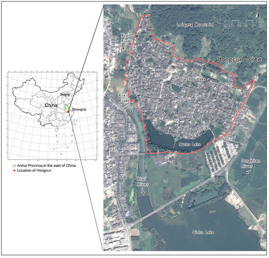
Figure 1.
Location and map of Hongcun and the surrounding environment.
The core built area of the village covers approximately 18 hectares, containing 138 well-preserved ancient houses from the China Ming (1368-1644 AD) and Qing (1644–1911 AD) dynasties. Its village site location, master plan and architectural layout form are guided by Chinese traditional geomantic theory, and have a direct relationship with the water system. Hongcun is one of only a handful of examples worldwide of a carefully planned ancient village that has been preserved to the present day (Figure 1).
2.2. Methods & Research Diagram
This paper firstly puts forward the hypothesis of the Human-Natural Integrated Ecological Planning (HNIEP) conceptual model, based on the related literature research, and assuming principles or elements of it should be followed, such as site selection, planning layout, and ecological infrastructure, etc.
Secondly, taking Hongcun’s ecological planning and construction as an example, this paper summarizes Hongcun’s extraordinary wisdom and experience to verify and support the hypothesis of the HNIEP Model. Specifically including links to the planning, construction, and ecosystem services of Hongcun, this paper makes an assessment of the effect of ecosystem services generated by the planning and construction of Hongcun. It also summarizes the ecological wisdom in the planning and construction of the Hongcun human settlement, which has been scientifically verified by this paper, including its wisdom in dealing with the relationship between human and nature; the wisdom of using the natural ecosystem pattern, process and function, especially the role of water systems in planning and building, and its functional use for aesthetic purpose in creating Hongcun landscape; and the wisdom of integrating the relationship between human life and production activities and the natural ecosystem, etc.
Finally, this paper explores the enlightenment of the HNIEP model on contemporary urban-rural planning and construction management, which is also the key lesson learned from the ecological wisdoms of Hongcun (Figure 2).
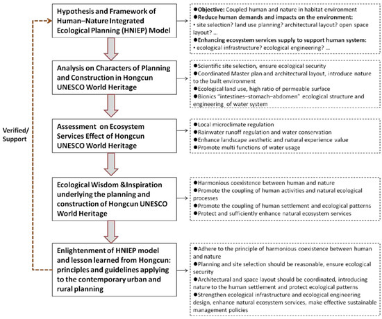
Figure 2.
Research diagram.
Technological research methods such as layout analysis, GIS analysis tools, VENT wind environment simulation (building ventilation VENT is an analysis tool designed to optimize the wind environment for building layout planning and building space division. The software is built on the AutoCAD platform and integrates modeling, meshing, flow field analysis, and result viewing.), 3D computer physical modeling by Sketch Up, DEM elevation analysis, and view analysis were used.
2.3. Hypothesis and Framework of the HNIEP Model
Through the aforementioned literature review, the services of ecosystems and the natural capital contributed to human welfare, both directly and indirectly [47]. How to deal with the relationship between man and nature reasonably and harmoniously, and how to couple human and natural systems, has become one of the focuses of research in ecological planning and ecosystem services, especially about improving the ecosystem services to support humans and reducing the human impact on ecosystems [48,49,50]. How to describe, classify, and value ecosystem functions, goods, and services [51] are also research focuses. Meanwhile, the implementation of ecosystem services to decision making [52,53] and integrated modeling are also needed [54]. Based on these, this paper puts forward the hypothesis of the Human-Natural Integrated Ecological Planning (HNIEP) conceptual model. The principles and elements of the HNIEP model should include following: Reducing human demands and impacts on the environment; using ecological planning methods, such as site selection, space layout, and land use patterns regulation, while enhancing the supply of ecosystem services to support human systems through optimizing ecological patterns; regulating ecological processes; and promoting ecological functions (Figure 3).
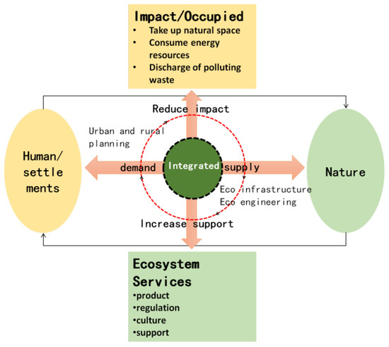
Figure 3.
Hypothesis and framework of the Human–Nature Integrated Ecological Planning (HNIEP) model.
2.4. Data
The data used in this article include map, literature, and on-site data collection. Map data is a combination of Google map and topographic maps, provided by the Huangshan Institute of Planning and Design. Diagrams such as the natural landscape, master plan and architectural layout, land use, water system, and a 3D Model of Hongcun were plotted based on the map data. Literature data include the Yi County Record [55] (Hongcun is located in Yi County, and the Yi County Record is the official record kept by the government on the local customs, climate, weather, economic and social data, etc.), national outdoor drainage design code [56], and related books and articles, from which weather data such as wind speed, rainfall, and runoff coefficient, etc., can be obtained. On-site data collection including water depth measurement, villagers’ interviews, photo records, and paper literature collections (the authors conducted a long-term field survey of Hongcun in 2001, 2005, 2010, and 2016). In addition, DEM altitude data were used for site selection analysis.
3. Key Planning and Construction Characteristics of Hongcun
The planning and construction of Hongcun has been studied by Chinese scholars. Wu [57] suggests that the characteristics of Hongcun include the pursuit of an ideal state of “harmony between man and nature”, the ingenious combination of landform and landscape, and vast street and water channel space. Wang [58] explored the historical processes underlying water system planning and construction in Hongcun, and argues that the water system represents the traditional settlement’s pursuit of perfection within an ideal living environment. Li [59] explored the wisdom of rainwater management in Hongcun, including the combination of stagnation, storage, and discharge. This paper will focus on the key planning and construction characteristics of site selection, master plan, architectural layout, land use, and water system in Hongcun.
3.1. Site Selection
Hongcun is surrounded by mountains on all sides, with Mt. Leigang nearby to the north, Mt. Donghsan to the east, Mt. Baolin to the west, and Mt. Guishan to the south at a relatively long distance. In addition, the village has water sources on three sides: the Xixi and Yangzhan rivers meet west of the village, the Dongbian river runs to the east, while to the south lies a big Lake called Qishu (Figure 4). The village faces south and is surrounded by water and mountains, which is the optimum situation within the traditional Chinese geomantic theory (Figure 4).
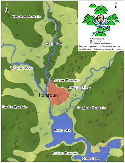
Figure 4.
Site selection analysis of Hongcun based on DEM elevation (the best geomantic location in the traditional Chinese geomantic theory, redrawn by an author, based on Chen Hong [60]).
Through DEM elevation analysis, Hongcun was found to be situated on relatively flat terrain amidst the surrounding mountains and interlaced rivers, with a topography gently sloping downwards from north to south. The entire village is approximately 2 m higher than the Xixi River to the west (Figure 4).
3.2. Master Plan and Architectural Layout
Hongcun covers a total land area of 18.2 hectares, with a total building floor area of 209,785 m2, building area of 62,630 m2, floor area ratio of 1.15, and building density of 34.38% (Table 1). The village layout is not in the more common chessboard pattern of traditional Chinese habitats (the vast majority of ancient Chinese habitats use horizontal and vertical chessboard road networks). Instead, Hongcun has been designed and constructed by adapting to local conditions and terrain and adopting the bionic buffalo-shaped layout, which is a nature-integrated design. The architectural layout of Hongcun is situated along streets and alleys, which, in turn, are located near water, protect local old trees, and leave enough open space for nature. Buildings are mainly one or two floors in height. The water system, streets, buildings, and squares, therefore, merge with the natural environment beyond, to create an ideal living environment (Figure 5).

Table 1.
Main indicators of the master plan of Hongcun.
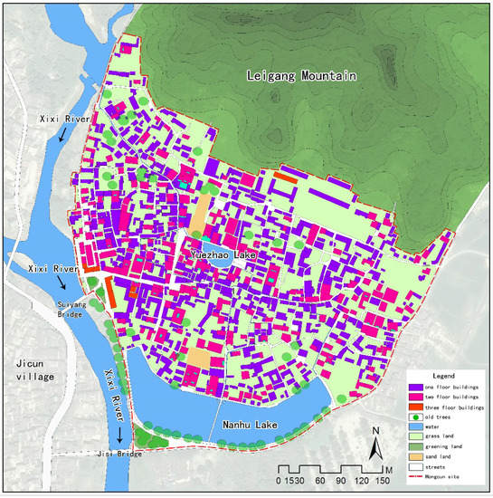
Figure 5.
Master plan, architectural layout, and land use map of Hongcun.
3.3. Land Use
Hongcun’s land use can be divided into six categories: Building, water, grass land, greening land (such are areas of artificial greening, tree-plant land), sand land, and stone roads (Figure 5). Among these, grass, greening, and sand land are permeable. The ratio of permeable surface area of Hongcun (44.08%) and water area (11.18%) is much higher than modern human settlements (Table 2).
Table 2.
Land use of Hongcun.
3.4. Artificial Water System
The water system of Hongcun is composed of a water inlet, canals, Lake Yuezhao, and Lake Nanhu which are all part of an artificial living water system planned and constructed almost a millennium ago. The water system adopts the unique bionic “buffalo” shape: Lake Yuezhao, in the center of the village, forms the “stomach”; Lake Qishu, on the southern edge of the village, forms the “abdomen”; and the winding water canals are the buffalo’s “intestines” (Figure 6).
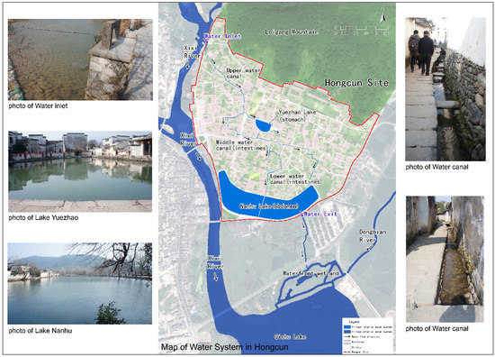
Figure 6.
Water system of Hongcun (photo by author).
The water system is 1222 m long, 1–2 m wide, and 0.5–2.5 m deep, and it is divided into upper, middle, and lower sections. The water inlet located in the northwest of the village carries water from the Xixi River. The upper section flows 30 m south from the inlet, then changes course to the southeast. The middle section then flows to the east along Lake Yuezhao and again changes course to the south. The lower section then twists and turns into Lake Nanhu, south through a waterfront wetland, and finally flows into Lake Qishu (Figure 6). The entire water system depends on gravity. The water level of the inlet is 3.96 m higher than the surface of Lake Nanhu, and there is an average water velocity of 21.6 m/s, over an area of 20,368.5 m2, which accounts for 11.18% of total village land.
4. Ecosystem Services Effect in Hongcun
The study found that the unique planning and construction of Hongcun has greatly promoted and affected the following four aspects of ecosystem services: Local microclimate regulation, rainwater runoff regulation and water conservation, landscape aesthetic and natural experience value, and multiple functions of water usage.
4.1. Regulate Local Microclimate and Form Ventilation Corridors
The entire village is approximately two meters higher than the Xixi River to the west, allowing easy water access while simultaneously limiting the risk of flooding and ensuring the ecological security of the village (Figure 4). In addition, in summer, the prevailing wind direction is south or southeast, and in winter it is north or northeast. Mt. Leigang lies to the north, at an altitude of 340–470 m, and a height relative to Hongcun of 60–190 m. This mountain, combined with the open area of Lake Qishu to the south, creates a microclimate of moist, cool wind in summer along the south-to-north incline. In winter, cold wind is blocked by Mt. Leigang (Figure 7), thus suggesting that pre-existing local knowledge of the terrain and climate was used to regulate the local climate of the village.
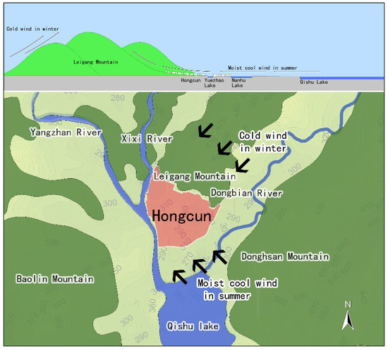
Figure 7.
Local microclimate regulation and natural terrain in Hongcun.
Hongcun’s architectural layout follows the natural north-high to south-low topography of the surrounding landscape. The village presents a slight deviation from this pattern where streets have been constructed along the water system to form open spaces. A 3D model of Hongcun (Figure 8) was created, and VENT wind environment analysis software was used to create a wind environment simulation of the village. The average wind speed was set to 1.5 m/s, based on Yi County records [55]. Prevailing directions of southeast and south were selected to simulate the summer wind environment. The results show that the open space wind speed is relatively high along Lake Nanhu, Lake Yuezhao and along the water system, forming a clear ventilation corridor for the prevailing summer wind. The building layout and open space along the water benefit from the increased ventilation created by this microclimate (Figure 8).
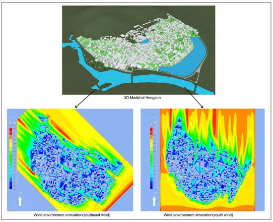
Figure 8.
3D model and wind environment simulation of Hongcun.
4.2. Enhance Rainwater Runoff Regulation and Water Conservation
The average annual rainfall in Hongcun is 1759.67 mm [55]. The total runoff volume control rate is 0.44 (Table 3), and the total water conservation capacity of the water system is approximately 830,000 cubic meters (Table 4). Hongcun’s water system, therefore, has the capacity to store a year’s average rainfall. Due to the high permeable surface ratio and water surface ratio, rainfall runoff is effectively regulated, resulting in high seepage and high water conservation levels, making it an ancient version of Sponge City (which is a new generation of urban stormwater management concept in China, and refers to the city with good “flexibility” in adapting to environmental change and responding to natural disasters caused by rain, also known as a “water-resilient city”. The common international terminology is “low impact on the development of rainwater system construction”).
Table 3.
Total runoff volume control rate in Hongcun.
Table 4.
Water conservation capacity in Hongcun.
4.3. Enhance Landscape Aesthetic and Natural Experience Value
The planning of Hongcun has been deliberately situated to introduce nature into the village, with the surrounding natural mountains coming into view from most points in the village, especially from the streets and the open space near the water system. This article selects five representative perspectives for view analysis, and abstracts images into four categories: Sky, green, water, and building views (Figure 9). The views of green, water, and sky comprise the majority, forming more than 70%, while the building view accounts for less than 30% (Table 5). Hongcun’s nature-integrated architectural layout, water system, and street space organization enhance the ecosystem services of landscape aesthetic and natural experience value.
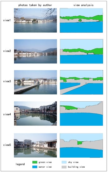
Figure 9.
View analysis for five representative perspectives in Hongcun. (View 1–3: Views from Lake Nanhu and surrounding buildings and environment. View 4–5: Views from Lake Yuezhao and surrounding buildings and environment.).
Table 5.
View proportion calculations for five representative perspectives in Hongcun.
4.4. Promote Multi Functions of Water Usage
In addition to rainwater runoff regulation and water conservation, the water systems of Hongcun also provide firefighting, irrigating, washing, drinking, and multiple other functions.
(1) Use as firefighting water:
Using GIS proximity analysis to calculate the shortest distance between each building and the water system, it was established that, of the 1055 building blocks in the village, 95.1% are within 100 m of the water system. Only one building is more than 200 m (208 m) away from the water system, while 12 are over 150 m away (Figure 10, Table 6). Because of the layout of the water system, all village residents are in proximity to water for household and agricultural production use. The proximity of the water system also meets the demand for easily accessible water in the event of fire.
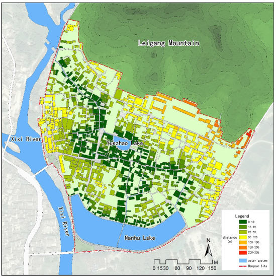
Figure 10.
Accessibility of water system (distance between buildings and water system).
Table 6.
The Nearest Distance of buildings from the water system.
(2) Use as irrigation, washing, and drinking water:
Many smaller canals run off the main canal at the heart of the water system, providing convenient water for household chores, such as laundry and garden irrigation. These canals were the “tap water” of the ancient village, with villagers drinking and washing in the “intestines”. Wang ancestors once had a rule that, before 8:00 am, water in the “intestines” could only be used for drinking, and after 8:00 am it could be used for washing. Because of such management measures, water quality remains good. Today, villagers continue to wash vegetables in the canal (Figure 11), and this water is piped directly into homes for household aquaculture (Figure 12).
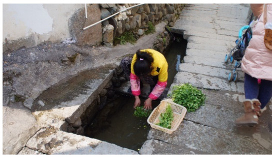
Figure 11.
Villagers still wash vegetables in the canal (photo by author).
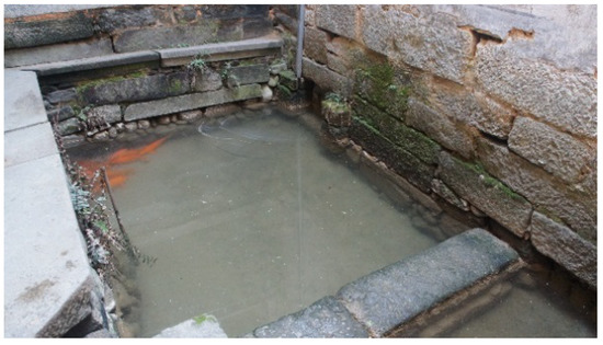
Figure 12.
Residential fishing pond still connected with the water system (photo by author).
5. Ecological Wisdom Underlying the Planning and Construction of Hongcun
This paper has thus far analyzed the ecosystem services effects generated by the planning and construction of Hongcun. The research described in this paper verifies that the planning and construction of Hongcun reflects excellent ecological wisdom, such as the concept of integrating human and nature, in order to sustainably utilize ecosystem patterns, processes and functions, and to integrate human life and production activities with natural ecosystems.
5.1. Harmonious Coexistence between Human and Nature Minimizes the Negative Influences of Human Settlement on Natural Ecosystems
The ingenious site selection, appropriate scale, scientific water system, coordinated streets, and architectural layout of Hongcun all reflect an ecological wisdom that harmonizes the relationship between humans and nature. It is based on a concept of human habitat and settlement within an environment that respects, conforms to, and is highly integrated with nature. In Hongcun, through site selection, layout, and planning methods, such as introducing nature into the village, a harmonious relationship of coexistence has been created and maintained between humans and the environment, thus minimizing the adverse impacts of human settlement and activities, and integrating humans and the natural environment in ways that complement each other.
5.2. Human Activities Are Regarded as an Inseparable Part of the Ecosystem, and Promote the Coupling of Human Activities and Natural Ecological Processes
The unique “intestines–stomach–abdomen” ecological structure of the Hongcun water system is the tactful imitation of a natural water system. It effectively combines utility, such as drinking, washing, irrigation, and firefighting, with recreation, landscape aesthetics, and the natural water cycle process, adhering to the excellent concepts of ecological balance and cycling, which can be expressed as “return after borrowing”. In ancient Hongcun, the water system was dependent on gravity, buildings were energy efficient, firewood, charcoal, and other renewable fuels were used, and human and animal excreta and other waste was returned to the land as agricultural fertilizer. Thus, it has an environmental purpose of closure of energy circles and waste management. Therefore, in ancient Hongcun, the human environment and human activities were regarded as part of the ecosystem, and human activities and ecological processes were effectively coupled, so that artificial and natural systems were interconnected loops.
5.3. Respectfully Utilize Natural Ecological Patterns, Incorporate Nature into Human Settlements, and Promote the Coupling of Human Settlement and Ecological Patterns
The site of the village was selected because it faces the water and backs onto hills, thus enjoying cool air from the south in summer and shelter from the north wind in winter, resulting in a well-regulated local climate. The layout is adapted to local conditions, which allows nature into the village and maintenance of ecological space due to relief, density of layout, the movement of water, and the aesthetic use of the surrounding landscape. The pattern of the built environment is coupled with the pattern of the natural environment, forming a harmonious whole which favorably enhances the aesthetic value of the landscape and the natural experience.
5.4. Protect and Sufficiently Enhance Natural Ecosystem Services
Planning, construction, and management policy in Hongcun fully realized the importance of ecosystem functions. For example, a high permeable surface ratio and a high water ratio enhanced water conservation, seepage, and runoff regulating functions, resulting in an ancient Sponge City system. This balanced water system layout improves water system accessibility, not only for household and agricultural use, but also for ventilation, cooling, and aesthetics. A policy of restricting certain activities to certain times of day enhanced the multiple functions of the water system, allowing drinking, washing, irrigation, and firefighting.
6. Conclusions and Discussion
Inspired by the ecological wisdom underlying the planning and construction of Hongcun, this paper proposes and verifies the Human-Natural Intergraded Ecological Planning (HNIEP) conceptual model for ecological planning and ecosystem services in urban and rural areas. Learning from the lessons that Hongcun has given us, and the new knowledge the HNIEP model brings to studies on ecosystem wisdom, recommended principles and guidelines applying to the contemporary urban and rural planning should include the following:
(1) Adhere to the principle of harmonious coexistence between humans and nature
Urban and rural planning should take the harmonious coexistence of humans and nature as its first principle. This should incorporate respect for nature, merging with the natural environment, adapting to local conditions, minimizing damage to nature, and integrating with natural ecology.
(2) Planning and site selection should be reasonable and ensure ecological security
Site selection of urban and rural settlements should fully analyze local environments and ecological patterns. Selecting suitable land for construction and development ensures long-term ecological security, avoids ecological disasters, protects natural ecological patterns from destruction, and makes conditional use of ecological patterns to promote the coupling of human settlement patterns and ecological patterns.
(3) Architectural and space layout should be coordinated, introducing nature to the human settlement and protecting ecological patterns
Architectural and space layout in urban and rural areas should make full use of underlying ecological factors. It should adjust measures to local conditions, and incorporate nature into the built environment. This could be achieved by, for example, combining water systems along ecological corridors and fusing road patterns and other ecological infrastructure with natural ecological patterns. Planning design should seek to promote nature and natural experiences within the built environment.
(4) Strengthen ecological infrastructure and ecological engineering design, make effective sustainable management policies
Ecological infrastructure and ecological engineering should take advantage of such features as permeable surfaces, artificial wetlands and urban forests, regulate ecological processes, and improve ecosystem services. For example, using sinking green land, reservoir, artificial wetland, natural revetment, and water-permeable paving to follow the model of the Sponge city to contemporary development zones in Chinese cities. Simultaneously, the formulation and system design of management policy should be strengthened to encourage and promote green building, rainwater collection, garbage recycling, clean energy use, and harmful pollutants control, etc.
The scale of Hongcun was relatively small, and lifestyles and living conditions in ancient times were limited. There was no electricity, tap water, modern toilets or sewers, no fossil fuel consumption, and no modern waste such as plastics, all of which seem to be inevitable elements of modern life. The ecological wisdom underpinning Hongcun’s planning and construction, however, can still provide lessons to the modern world, especially with regard to harmony and symbiosis between humans and the natural environment, the integration of nature into urban planning, and the management of human settlements.
Due to limitations of study area, this paper has analyzed only one ancient village amongst many across China’s vast territory, each of which can teach us lessons about sustainable human settlement. Future research should classify and summarize more of these traditional ecological planning methods, in order to form a series of research results of traditional ecological wisdom to inspire contemporary sustainable urban and rural development.
Acknowledgments
This work was supported by the National Natural Science Foundation of China (No. 71533005).
Author Contributions
Z.O. and S.Z. conceived and designed the research; S.Z. analyzed the data and wrote the paper; S.Z., B.H. and Z.O. revised the paper; S.Z. and D.W. do the site field survey and villager interview; S.Z., B.H. and D.W. contributed materials; all authors read and approved the paper.
Conflicts of Interest
The authors declare no conflict of interest.
References
- Wang, R.S.; Li, F.; Hu, D.; Li, B.L. Understanding eco-complexity: Social-Economic-Natural Complex Ecosystem approach. Ecol. Complex. 2011, 8, 15–29. [Google Scholar] [CrossRef]
- Jorgenson, A.K.; Burns, T.J. Effects of rural and urban population dynamics and national development on deforestation in less-developed countries, 1990–2000. Sociol. Inq. 2007, 77, 460–482. [Google Scholar] [CrossRef]
- Belant, J.L. Gulls in urban environments: Landscape-level management to reduce conflict. Landsc. Urban Plan. 1997, 38, 245–258. [Google Scholar] [CrossRef]
- Di Giulio, M.; Holderegger, R.; Tobias, S. Effects of habitat and landscape fragmentation on humans and biodiversity in densely populated landscapes. J. Environ. Manag. 2009, 90, 2959–2968. [Google Scholar] [CrossRef] [PubMed]
- Transforming Our World: The 2030 Agenda for Sustainable Development. Available online: https://sustainabledevelopment.un.org/post2015/transformingourworld (accessed on 21 October 2015).
- The New Urban Agenda. Available online: http://habitat3.org/wp-content/uploads/NUA-English.pdf (accessed on 23 December 2016).
- Xi Jinping’s Report at 19th CPC National Congress. Available online: http://www.xinhuanet.com/english/download/Xi_Jinping’s_report_at_19th_CPC_National_Congress.pdf (accessed on 18 October 2017).
- Pickett, S.T.A.; Cadenasso, M.L.; Grove, J.M.; Nilon, C.H.; Pouyat, R.V.; Zipperer, W.C.; Costanza, R. Urban ecological systems: Linking terrestrial ecological, physical, and socioeconomic components of metropolitan areas. Annu. Rev. Ecol. Syst. 2001, 32, 127–157. [Google Scholar] [CrossRef]
- Fang, C.L.; Liu, H.M.; Li, G.D. International progress and evaluation on interactive coupling effects between urbanization and the eco-environment. J. Geogr. Sci. 2016, 26, 1081–1116. [Google Scholar] [CrossRef]
- Jianguo, W.; Wei-Ning, X.; Jingzhu, Z. Urban ecology in China: Historical developments and future directions. Landsc. Urban Plan. 2014, 125, 222–233. [Google Scholar] [CrossRef]
- Gomez-Baggethun, E.; Barton, D.N. Classifying and valuing ecosystem services for urban planning. Ecol. Econ. 2013, 86, 235–245. [Google Scholar] [CrossRef]
- Luederitz, C.; Brink, E.; Gralla, F.; Hermelingmeier, V.; Meyer, M.; Niven, L.; Panzer, L.; Partelow, S.; Rau, A.-L.; Sasaki, R.; et al. A review of urban ecosystem services: Six key challenges for future research. Ecosyst. Serv. 2015, 14, 98–112. [Google Scholar] [CrossRef]
- Guisan, A.; Zimmermann, N.E. Predictive habitat distribution models in ecology. Ecol. Model. 2000, 135, 147–186. [Google Scholar] [CrossRef]
- Grunewald, K.; Bastian, O. Special Issue: “Maintaining Ecosystem Services to Support Urban Needs”. Sustainability 2017, 9, 1647. [Google Scholar] [CrossRef]
- Howard, E. Tomorrow: A Peaceful Path to Reform; Swan Sonnenschein: London, UK, 1898. [Google Scholar]
- Kenworthy, J.R. The eco-city: Ten key transport and planning dimensions for sustainable city development. Environ. Urban 2006, 18, 67–85. [Google Scholar] [CrossRef]
- Roseland, M. Dimensions of the eco-city. Cities 1997, 14, 197–202. [Google Scholar] [CrossRef]
- Antuña-Rozado, C.; García-Navarro, J.; Reda, F.; Tuominen, P. Methodologies Developed for EcoCity Related Projects: New Borg El Arab, an Egyptian Case Study. Energies 2016, 9, 631. [Google Scholar] [CrossRef]
- Jabareen, Y.R. Sustainable urban forms—Their typologies, models, and concepts. J. Plan. Educ. Res. 2006, 26, 38–52. [Google Scholar] [CrossRef]
- Campbell, S. Green cities, growing cities, just cities? Urban planning and the contradictions of sustainable development. J. Am. Plan. Assoc. 1996, 62, 296–312. [Google Scholar] [CrossRef]
- Bowler, D.E.; Buyung-Ali, L.; Knight, T.M.; Pullin, A.S. Urban greening to cool towns and cities: A systematic review of the empirical evidence. Landsc. Urban Plan. 2010, 97, 147–155. [Google Scholar] [CrossRef]
- Li, F.; Wang, R.S.; Paulussen, J.; Liu, X.S. Comprehensive concept planning of urban greening based on ecological principles: A case study in Beijing, China. Landsc. Urban Plan. 2005, 72, 325–336. [Google Scholar] [CrossRef]
- Dietz, M.E. Low impact development practices: A review of current research and recommendations for future directions. Water Air Soil Pollut. 2007, 186, 351–363. [Google Scholar] [CrossRef]
- McHarg, I.L.; Sutton, J. Ecological plumbing for the Texas coastal plain: The Woodlands new town experiment. Landsc. Archit. 1975, 65, 80–90. [Google Scholar]
- Herrington, S. The Nature of Ian McHarg’s Science. Landsc. J. 2010, 29, 1–20. [Google Scholar] [CrossRef]
- McHarg, I.L. Design with Nature; Natural History Press: Garden City, NY, USA, 1969. [Google Scholar]
- Desouza, K.C.; Flanery, T.H. Designing, planning, and managing resilient cities: A conceptual framework. Cities 2013, 35, 89–99. [Google Scholar] [CrossRef]
- Jabareen, Y. Planning the resilient city: Concepts and strategies for coping with climate change and environmental risk. Cities 2013, 31, 220–229. [Google Scholar] [CrossRef]
- Wamsler, C.; Brink, E.; Rivera, C. Planning for climate change in urban areas: From theory to practice. J. Clean. Prod. 2013, 50, 68–81. [Google Scholar] [CrossRef]
- Cetin, M. Evaluation of the sustainable tourism potential of a protected area for landscape planning: A case study of the ancient city of Pompeipolis in Kastamonu. Int. J. Sustain. Dev. World Ecol. 2015, 22, 490–495. [Google Scholar] [CrossRef]
- Cetin, M. Using GIS analysis to assess urban green space in terms of accessibility: Case study in Kutahya. Int. J. Sustain. Dev. World Ecol. 2015, 22, 420–424. [Google Scholar] [CrossRef]
- Cetin, M. Sustainability of urban coastal area management: A case study on Cide. J. Sustain. For. 2016, 35, 527–541. [Google Scholar] [CrossRef]
- Cetin, M.; Zeren, I.; Sevik, H.; Cakir, C.; Akpinar, H. A study on the determination of the natural park’s sustainable tourism potential. Environ. Monit. Assess. 2018, 190, 167. [Google Scholar] [CrossRef] [PubMed]
- Cetin, M. Determining the bioclimatic comfort in Kastamonu City. Environ. Monit. Assess. 2015, 187, 10. [Google Scholar] [CrossRef] [PubMed]
- DeCandido, R.; Calvanese, N.; Alvarez, R.V.; Brown, M.I.; Nelson, T.M. The naturally occurring historical and extant flora of Central Park, New York City, New York 1857–2007. J. Torrey Bot. Soc. 2007, 134, 552–569. [Google Scholar] [CrossRef]
- Cao, S.; Liu, X.; Er, H. Dujiangyan Irrigation System—A world cultural heritage corresponding to concepts of modern hydraulic science. J. Hydro-Environ. Res. 2010, 4, 3–13. [Google Scholar] [CrossRef]
- Li, K.; Xu, Z. Overview of Dujiangyan Irrigation Scheme of ancient China with current theory. Irrig. Drain. 2006, 55, 291–298. [Google Scholar] [CrossRef]
- Morren, G.E.B. Traditional ecological knowledge—Wisdom for sustainable development—Williams, N.M., Baines, G. Am. Anthropol. 1995, 97, 174–175. [Google Scholar]
- Turner, N.J.; Ignace, M.B.; Ignace, R. Traditional Ecological Knowledge and Wisdom of aboriginal peoples in British Columbia. Ecol. Appl. 2000, 10, 1275–1287. [Google Scholar] [CrossRef]
- Ruotsala, H. Ancestors’ Wisdom or Desktop Reindeer Management? The Role of Traditional Ecological Knowledge in Contemporary Reindeer Herding; White Horse Press: Cambridge, UK, 2011. [Google Scholar]
- Xiang, W.-N. Ecophronesis: The ecological practical wisdom for and from ecological practice. Landsc. Urban Plan. 2016, 155, 53–60. [Google Scholar] [CrossRef]
- Wang, X.; Palazzo, D.; Carper, M. Ecological wisdom as an emerging field of scholarly inquiry in urban planning and design. Landsc. Urban Plan. 2016, 155, 100–107. [Google Scholar] [CrossRef]
- Young, R.F. Modernity, postmodernity, and ecological wisdom: Toward a new framework for landscape and urban planning. Landsc. Urban Plan. 2016, 155, 91–99. [Google Scholar] [CrossRef]
- Zhang, L.; Yang, Z.; Voinov, A.; Gao, S. Nature-inspired stormwater management practice: The ecological wisdom underlying the Tuanchen drainage system in Beijing, China and its contemporary relevance. Landsc. Urban Plan. 2016, 155, 11–20. [Google Scholar] [CrossRef]
- Patten, D.T. The role of ecological wisdom in managing for sustainable interdependent urban and natural ecosystems. Landsc. Urban Plan. 2016, 155, 3–10. [Google Scholar] [CrossRef]
- UNESCO World Heritage List: Ancient Villages in Southern Anhui-Xidi and Hongcun. Available online: http://whc.unesco.org/en/list/1002 (accessed on 2 December 2000).
- Costanza, R.; dArge, R.; deGroot, R.; Farber, S.; Grasso, M.; Hannon, B.; Limburg, K.; Naeem, S.; Oneill, R.V.; Paruelo, J.; et al. The value of the world’s ecosystem services and natural capital. Nature 1997, 387, 253–260. [Google Scholar] [CrossRef]
- Liu, J.; Dietz, T.; Carpenter, S.R.; Folke, C.; Alberti, M.; Redman, C.L.; Schneider, S.H.; Ostrom, E.; Pell, A.N.; Lubchenco, J.; et al. Coupled human and natural systems. AMBIO J. Hum. Environ. 2007, 36, 639–649. [Google Scholar] [CrossRef]
- Liu, J.; Dietz, T.; Carpenter, S.R.; Alberti, M.; Folke, C.; Moran, E.; Pell, A.N.; Deadman, P.; Kratz, T.; Lubchenco, J.; et al. Complexity of coupled human and natural systems. Science 2007, 317, 1513–1516. [Google Scholar] [CrossRef] [PubMed]
- Liu, J.G.; Hull, V.; Ouyang, Z.Y.; Zhang, H.M. Future Directions for Coupled Human and Natural Systems Research; Oxford University Press: New York, NY, USA, 2016. [Google Scholar]
- De Groot, R.S.; Wilson, M.A.; Boumans, R.M.J. A typology for the classification, description and valuation of ecosystem functions, goods and services. Ecol. Econ. 2002, 41, 393–408. [Google Scholar] [CrossRef]
- Daily, G.C.; Matson, P.A. Ecosystem services: From theory to implementation. Proc. Natl. Acad. Sci. USA 2008, 105, 9455–9456. [Google Scholar] [CrossRef] [PubMed]
- Daily, G.C.; Polasky, S.; Goldstein, J.; Kareiva, P.M.; Mooney, H.A.; Pejchar, L.; Ricketts, T.H.; Salzman, J.; Shallenberger, R. Ecosystem services in decision making: Time to deliver. Front. Ecol. Environ. 2009, 7, 21–28. [Google Scholar] [CrossRef]
- Costanza, R.; de Groot, R.; Braat, L.; Kubiszewski, I.; Fioramonti, L.; Sutton, P.; Farber, S.; Grasso, M. Twenty years of ecosystem services: How far have we come and how far do we still need to go? Ecosyst. Serv. 2017, 28, 1–16. [Google Scholar] [CrossRef]
- Yi County Record. Available online: http://60.166.6.242:8080/was40/index_sz.jsp?rootid=8857&channelid=51407 (accessed on 1 December 2017). (In Chinese).
- Code for Design of Outdoor Wastewater Engineering (GB 50014-2006: 2016 edition). Available online: http://www.zzguifan.com/webarbs/book/54774/2884110.shtml (accessed on 28 June 2016). (In Chinese).
- Wu, X.; Chen, A.; Wan, G. World Cultural Heritage—Study of South Anhui ancient village characteristics. Archit J. 2001, 8, 59–61. (In Chinese) [Google Scholar]
- Haofeng, W. Planning, construction and management of Hongcun water system. Dev. Small Cities Towns 2008, 51–55. (In Chinese) [Google Scholar]
- Li, Z.; Che, W.; Wang, J.; Yan, P.; Zhao, Y. The Enlightment of Sponge City Construction from Ancient Chinese Stormwater Management Wisdom: A Case Study of Hongcun. Urban Dev. Stud. 2015, 22, 1–5. (In Chinese) [Google Scholar]
- Chen Hong, L.P. The Spatial Pattern of Fengshui and its Impact on Chinese Traditional Urban Planning. City Plan. Rev. 1995, 4, 18–21. (In Chinese) [Google Scholar]
© 2018 by the authors. Licensee MDPI, Basel, Switzerland. This article is an open access article distributed under the terms and conditions of the Creative Commons Attribution (CC BY) license (http://creativecommons.org/licenses/by/4.0/).