Low-Cost Mapping and Publishing Methods for Landscape Architectural Analysis and Design in Slum-Upgrading Projects

Abstract
: The research project “Grassroots GIS” focuses on the development of low-cost mapping and publishing methods for slums and slum-upgrading projects in Manila. In this project smartphones, collaborative mapping and 3D visualization applications are systematically employed to support landscape architectural analysis and design work in the context of urban poverty and urban informal settlements. In this paper we focus on the description of the developed methods and present preliminary results of this work-in-progress.1. Introduction
In 2001, virtually one billion people lived in urban slums. In 2030 the global number of slum dwellers is expected to increase to about 2 billion, if no significant changes are taking place [1]. The worldwide doxology of city life detracts from the shady side of the urbanization process. Asia dominates the global picture of this shady side with 60 per cent of the world's total slum dwellers [1]. Megacities, with populations in excess of 8 million, and hypercities, with more than 20 million inhabitants [2], are contemporary epicenters of urban poverty. The urban poor in such megacities are mainly living in informal settlements or slums.
Slums are vast, challenging and fascinating urban worlds, but almost fully eschewed by the architectural design disciplines – definitely “landscape architecture” is a foreign word there [3]. The common avoidance of slum areas is understandable. Anyhow, the sheer number of slum dwellers and their unacceptable living conditions are an unmistakable indication of the importance of urban slums as a work task for designers. Slum upgrading initiatives only can be successful, if they are entrenched in the participation of the resident dwellers and the engagement of groups of volunteers, in conjunction with intensive links to the local government and administration. Sensitive slum upgrading is an interminable, dusty and malodorous working field. It means “dirty work” [4], “sweat equity” [5] for dwellers and volunteers, embedded in a cross fire of bottom-up activities and building stones, instead of top-down master plans and pre-establishments. Grassroots engagement is predicated on big numbers of people, but as a rule it faces small or diminutive budgets. In terms of design efforts, expensive and sophisticated methods and tools have to be replaced by pragmatic, simple and effective instruments that allow basic fieldwork and in situ design.
Slum areas are the most unsurveyed and thus most untraceable parts of megacities. Although some dwellers have access to the Internet (e.g., at Internet cafés or even mobile Internet), their informal settlements frequently appear as blank spots — unmapped areas and neglected space on official maps and planning materials. As a form of illegal land use, slums are blinded out from the radar of planners and public or commercial cartography, e.g., online maps. Accordingly, Google Streetview and Teleatlas forgo the areas where the poor live. The majority of urban slums shows no street names and no formal addresses [3]. No wonder that informal settlers extensively live in non-consideration. For example Kibera, Kenya, one of Africa's largest slums, was depicted as wild forest on official maps, and deemed illegal and ignored by the government for decades [6]. Since 2009 the Map Kibera project has successfully engaged and trained local youth to map their marginalized community, e.g., by using GPS devices and OpenStreetMap (OSM), the collaborative, open source project to create a free editable map of the world [7]. This project put Kibera on the world map and is currently trying to use the geographical data to improve the delivery of services and the implementation of projects. Community members have been enabled to become both most important consumers and creators of information resources [6].
1.1. Study Area
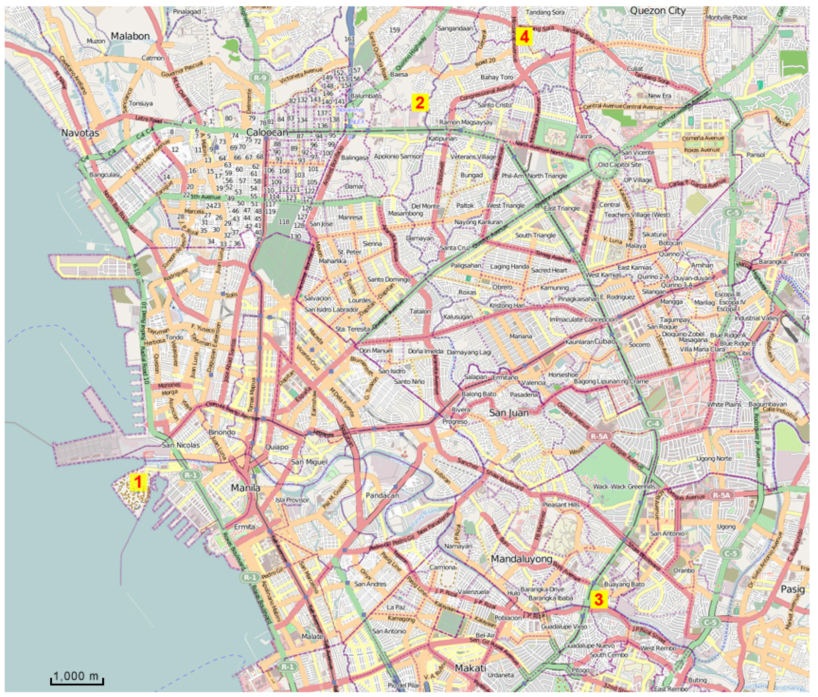
This paper describes the first and second of three fieldwork studies in the context of the research project “Grassroots GIS (geographic information system). Development of low cost mapping and publishing methods for slums and slum-upgrading projects in Manila”. Metro Manila is one of the icons of Asian megacities in developing country context. The greater urban area of Manila with a population at around 21 million people is the world's 5th largest urban agglomeration [8]. Metro Manila contains the city of Manila, national capital of the Philippines, as well as sixteen surrounding cities and municipalities. Metro Manila is a rapidly growing “endless city” [9] with all imaginable characteristics of urban affluence as well as of bitter urban poverty. Vast parts of Metro Manila-an estimated 40% portion-have to be attributed to urban informal settlements or slums.
The project follows from preparatory work and the first investigative fieldtrip by the authors in 2010 [3]. The research is conducted in combination with special landscape design studios in the context of the Master of Landscape Architecture program (MLA), National University of Singapore. These studio projects are related to and organized in cooperation with the Philippine grassroots movement Gawad Kalinga (GK). The mission of Gawad Kalinga – meaning to give care – reads as follows: “Building Communities to End Poverty”. Their method is baldly: “Land for the Landless. Homes for the Homeless. Food for the Hungry” [5].
Beneficiaries work hand-in-hand in bayanihan (Filipino term for teamwork and cooperation) with GK volunteers in building the infrastructure and structures of the community. The kapitbahayan (association of GK homeowners) composed of the beneficiaries themselves, take on multiple roles and undergo various leadership trainings. The beneficiaries learn to take ownership of their community and are empowered to help themselves and help others [5]. The GK slum-upgrading project areas are denoted as villages, and that is exactly what they reminded us: Children playing on the streets, pets and livestock in between and sometimes very, sometimes less successful attempts of ornamental gardening and urban farming.
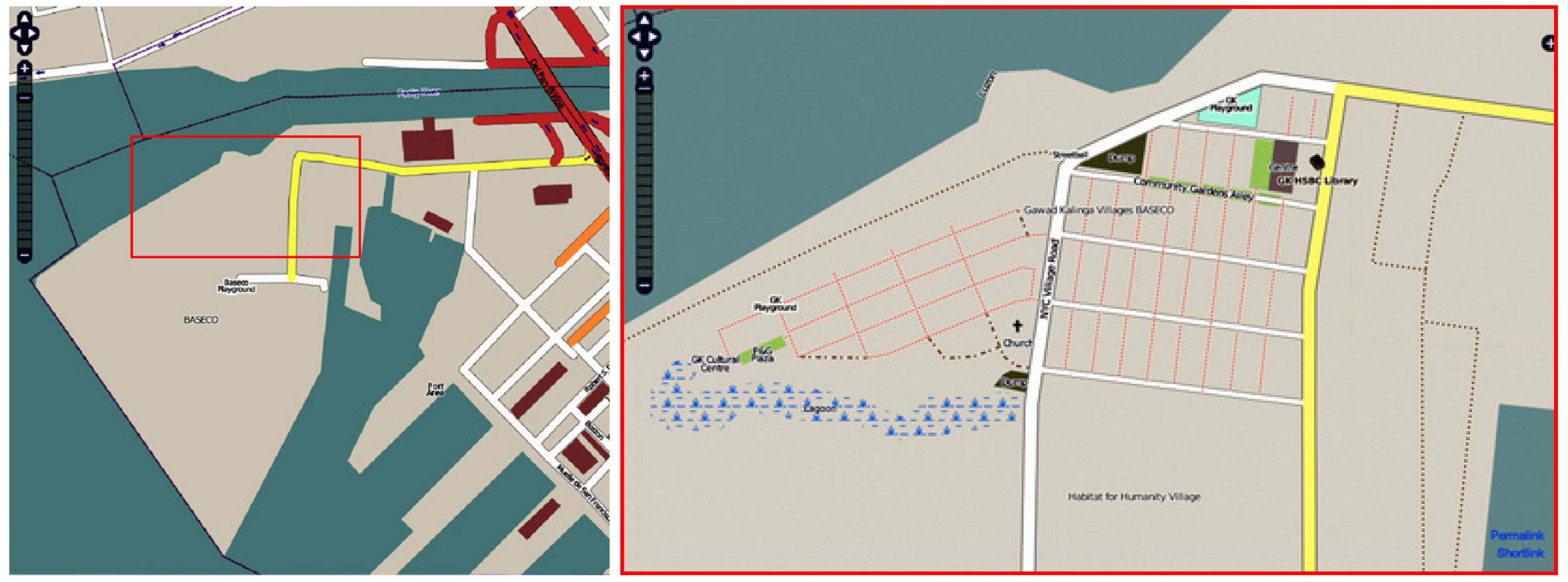
Landscape architectural design in slum areas is facing a categorical scarcity of space. Therefore, large projects as parks or other representative big outdoor spaces are out of place [3]. It is the small, unimposing micro-plot that counts in a slum and there are uncounted possibilities of designing essentials as an outdoor designer. In 2010, the students worked on the topic “Needle in a Haystack Gardens – Manila” [10], focusing on microdesigns of urban gardens or garden elements that contribute to a healthy environment and to improved living conditions in two selected GK villages (Figure 1).
The first one is situated within a notorious slum called Baseco, situated at the estuary of Pasig River and the most central harbor front area of Manila City. The second site is the GK village Espiritu Santo, surrounded by a vast slum area with the euphemistic name Sitio Pajo in Quezon City (Metro Manila). The students had been asked to specialize on productive forms of gardens that can provide precious food for the table [5].
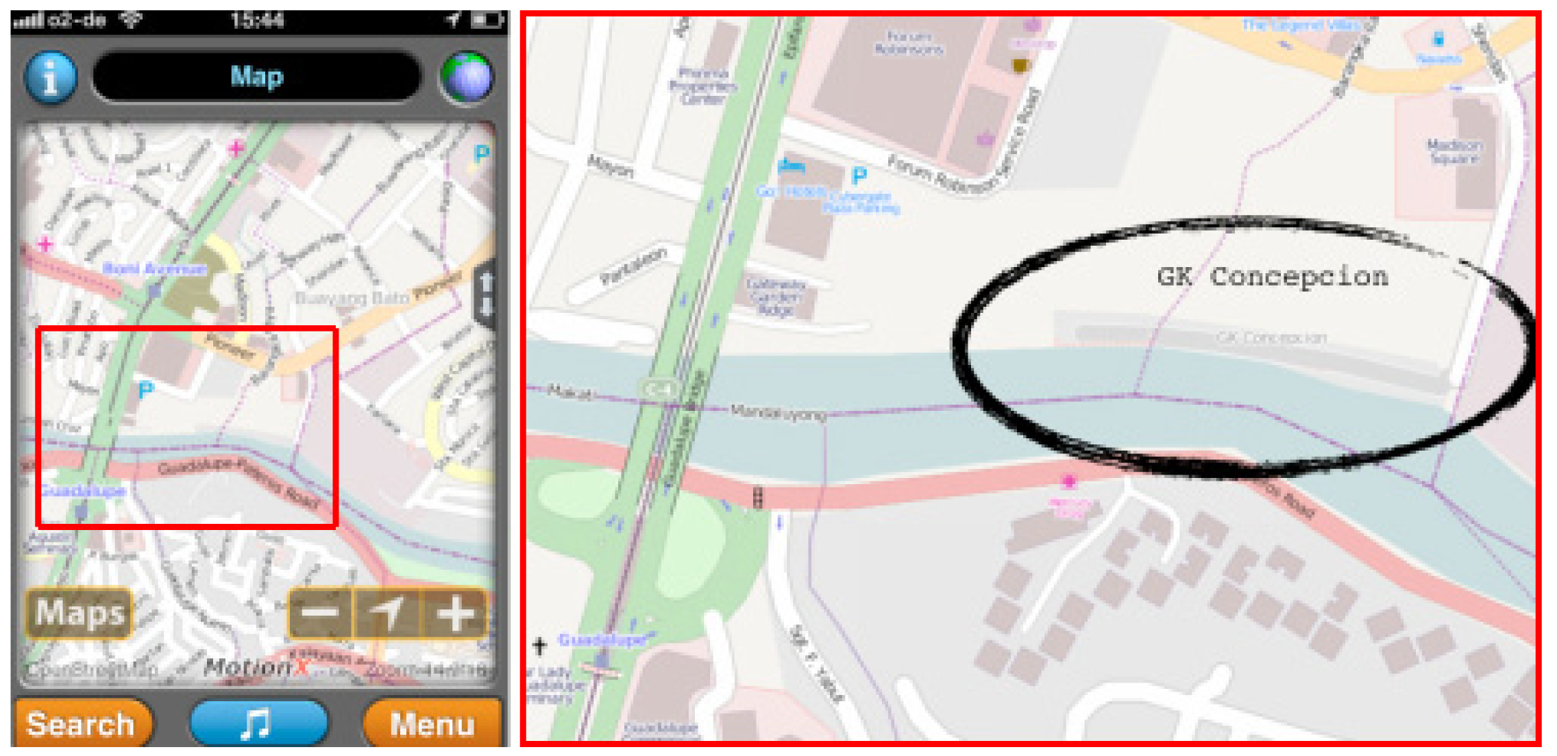
This year, 2011, the “designs for the real world” [11] of the students focused urban farming and livelihood ideas for two other selected GK villages in Metro Manila – Concepcion, Barangay Buayang Bato (administrative district) in Mandaluyong City and Telus in Quezon City [12] (Figure 1).
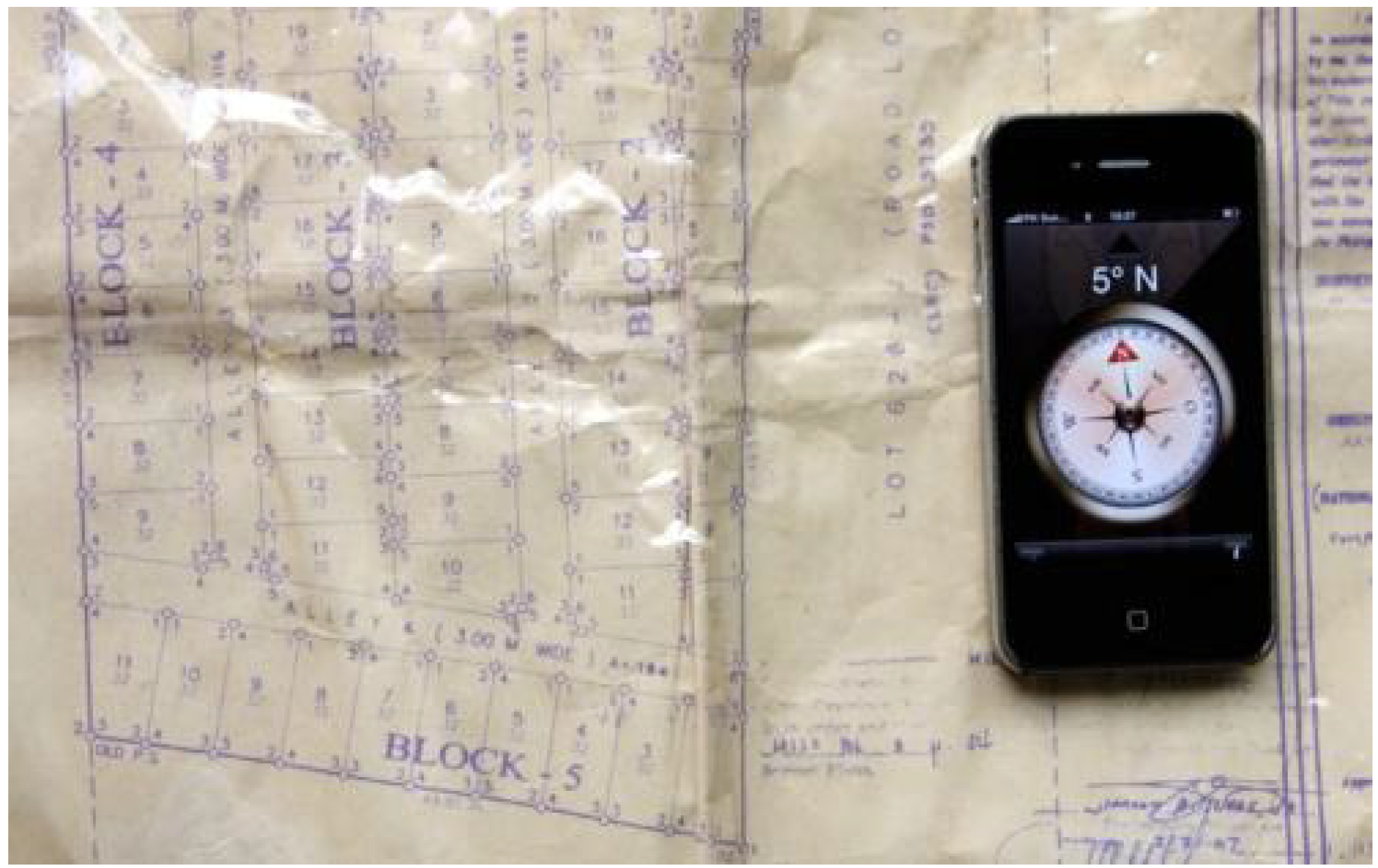
Only half of the GK villages that the authors have visited with MLA students could provide a lot plan, which means a creasy laminated hard copy of a rough hand drawing – without georeferencing (Figure 2). GK officials and supporters acknowledge that projects suffer from the absence or shortcomings of geographical data, and precise base maps (2nd Gawad Kalinga Global Summit, National University of Singapore, pers. comm., June 25–27, 2010).
The overriding goal of the described research is to contribute to the extrication of urban slums and slum-upgrading projects from non-consideration and invisibility. Secondary aim is to create reliable geographical data for directed design interventions in these environments. Grassroots GIS relies on the bottom-up principle, aims on outdoor design inclusive planting design, and integrates 2D and 3D geospatial data and tools for the purpose of landscape design activities. From 2010 to 2013, we tend to develop a toolbox and user-generated geospatial content process that supports mapping, storing, interactive design, disseminating, and interactive visualizing of landscape architectural interventions in the context of urban informal settlements. Target users of the presented low-cost mapping and publishing methods are volunteers such as planners, students or private individuals, and those GK beneficiaries, who build and inhabit the upgraded settlements. First stage users of the collected geographical data are students of our design studios. The research hypothesis reads as follows: Grass Roots GIS can provide elementary planning material for the design process of systematic slum upgrading initiatives and it can contribute to the step-by-step deliverance of informal settlers from non-consideration and addresslessness. Placing the design proposals and project areas on the Internet adds geographical details and could lead to spatial identity, comprehensiveness and enhanced understanding of design ideas for the otherwise untraceable informal worlds in the haystack of the megacity. The possibility to navigate to new addresses and edited entries on online maps and digital globes presumably sharpens the sense of orientation and spatial awareness.
In this paper we present and discuss our methods, preliminary findings, and the iterative, experimental design of our approach.
2. Methods and Tools
Slum-upgrading work of non-profit organizations such as Gawad Kalinga faces small or diminutive budgets, thence Grassroots GIS tries to build on inexpensive methods and technology, i.e., uncomplicated workflows, easy or free access to applied tools, geographical data and georeferenced design data as well as open source, open standard and low-cost or cost-free software, data storage, and dissemination possibilities [3]. Giusti de Pérez and Pérez [14] showed that “GIS can help make public projects visible, especially in the eyes of community and official institutions that finance improvements”. Standard GIS has also proved to be useful for the managing process of improvement interventions in squatter developments, which involve a myriad of small and medium construction tasks [14]. While standard GIS seems far too complex and possibly expensive for our presented approach, Grassroots GIS is aiming at operation below the project level. It is meant to be an initial explorer toolbox that helps making completely unmapped parts of the city visible. Also remote sensing could benefit from fieldwork data—acquired via the Grassroots GIS method—to “ground truth” classification of informal settlements [15].
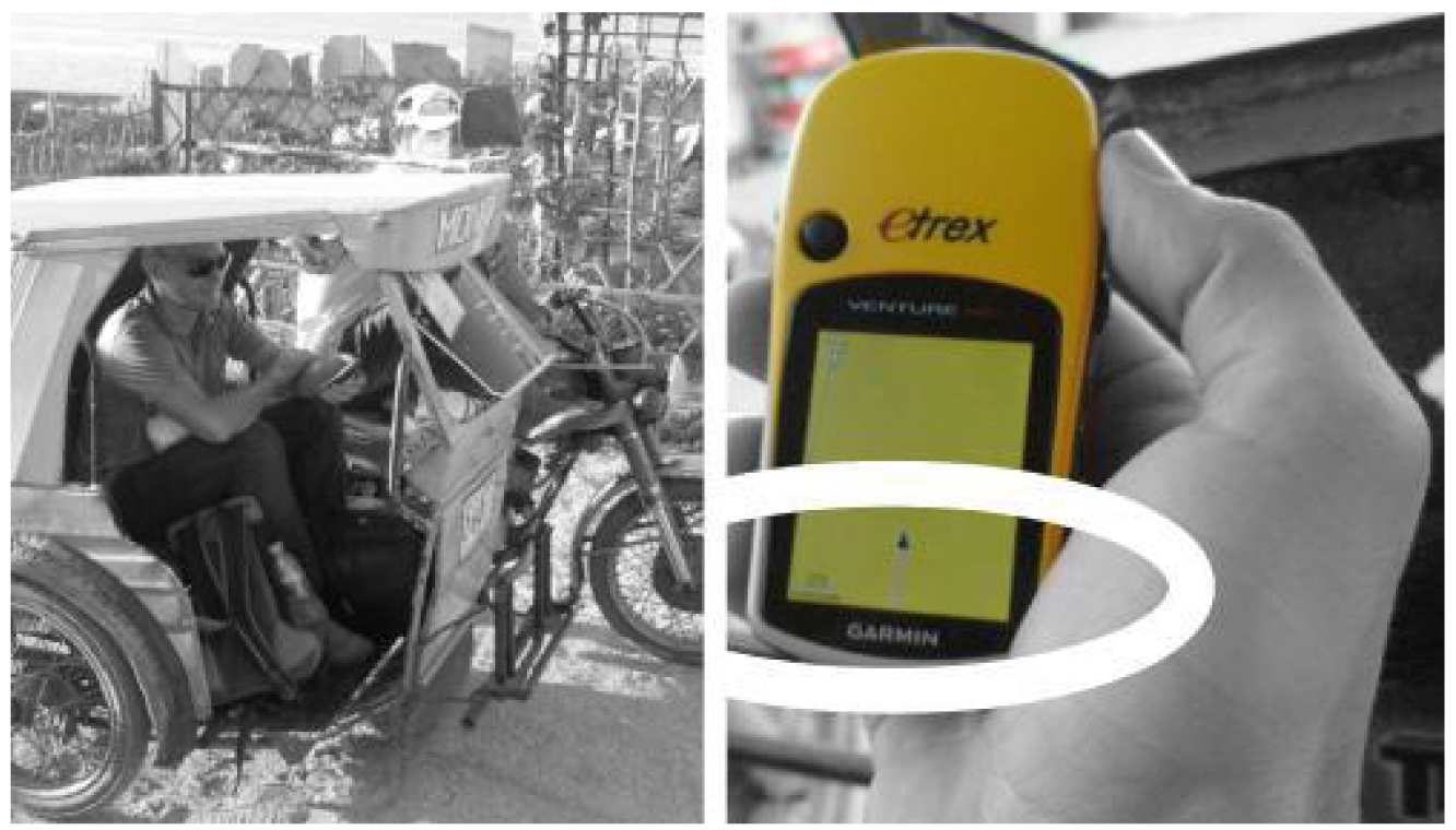
In 2010, a low cost (Garmin) GPS device and a consumer digital compact camera had represented our only digital equipment.
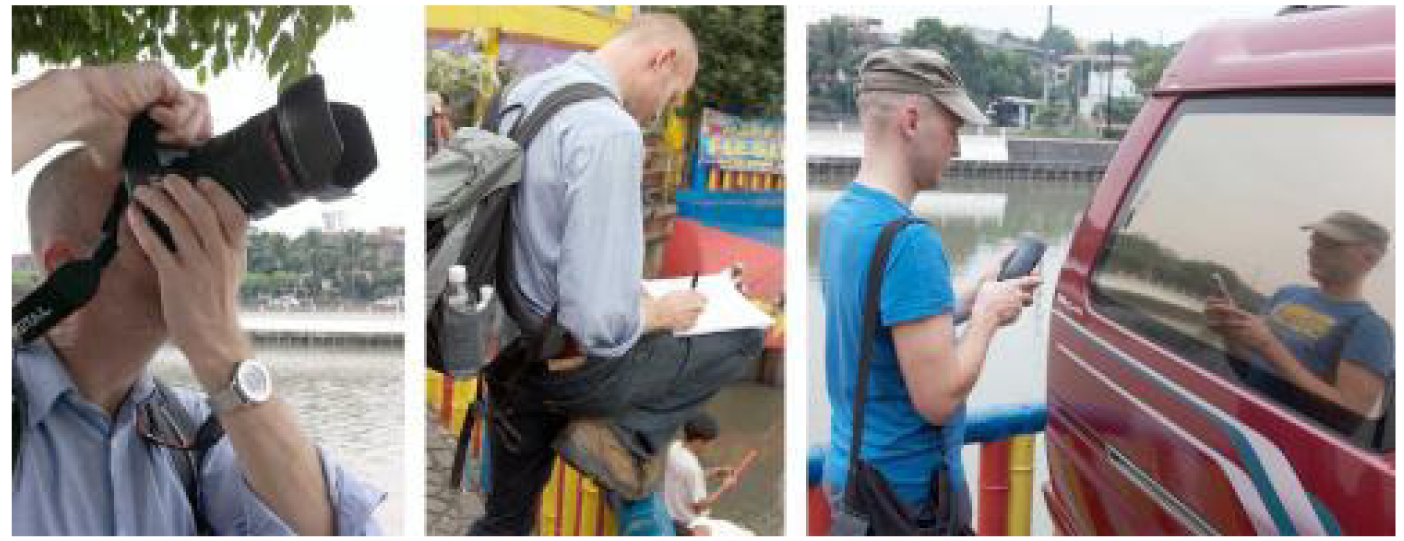
In 2011, we invested some money in a certain hardware and software upgrade (Figure 3). In addition to the GPS device we bought Apple iPhones 4, equipping them with some free or low-cost applications (“Apps”) for our fieldwork. The iPhone 3G was the first consumer device to provide a seamless integration of three positioning technologies: Assisted GPS (A-GPS), WiFi positioning and cellular network positioning. Tests [16] indicate that A-GPS locations obtained using the iPhone 3G are much less accurate than those from regular dedicated GPS units. Also a better and primarily faster semi-professional DSLR camera (Canon EOS 550D and 18-135 IS II lens) found its way into our luggage. From more than 300,000 available iPhone Apps [17] in January 2011 we have chosen the modest number of less than 10 Apps.
2.1. Mapping
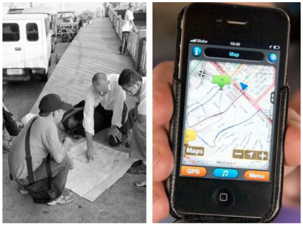
Finding the area of operation – in situ – forms the first step of Grassroots GIS in slum areas. In Manila we faced situations that GK villages only could be found after several indications given by local dwellers on the street – even though we had an extremely experienced driver and a member of the GK organization with us, who regularly goes to the sites (Figure 4). We had the GPS device and iPhone respectively but no basic maps of the GK sites are available so far, showing any street of the searched slum/slum upgrading area.
Second step of Grassroots GIS is to pace off all accessible streets, lanes and pathways of the project area with a GPS device; in 2010, we used a low cost Garmin product. In the totally unmapped slum areas, this tracking act truly forms a way of “volunteered geography” [18], exploring untrodden paths of urban public realm (Figure 5) and contributing to the growing global patchwork of self-generated, amateur geographic information.
Third step is to upload and publish the geographical data on OSM. Back at our accommodation, the fieldwork data is edited using the open source Java OpenStreetMap Editor (JOSM) [19], which allows processing of raw data and file preparation for web-based publication on OSM. In 2011, we used the iPhone instead of the Garmin device. After some pre-fieldtrip testing of MotionX GPS Lite, the limited but cost-free version of MotionX GPS, we decided to rely on MotionX GPS ($2.99) [20] during fieldwork. According to the developer, the App is the leading GPS App for the iPhone and iPad. “Over eight million iPhone or iPad users have chosen MotionX” [20]. The App offers an OSM download feature and caches the map tiles. This way, users can avoid expensive data roaming on-site.
2.2. Photographic Documentation
Designing in slums means highly detailed, small-scale work. It is impossible to remember all relevant details after the fieldtrip, without having an area-wide and building-sharp photo documentation of the project site. For this purpose Google Street View would be the state-of-the-art tool, but for a city like Manila – and other cities of developing countries – it is not available. For that reason also the “luxury” of an automatically generated Google Street View 3D model of selected city streets is not applicable. A sufficiently detailed working model has to be built by hand. In 2010, we used our standard digital camera to photograph all relevant façades, front gardens, public spaces and streets. In 2011, we used 3 camera Apps [17]: ProCamera ($2.99), a powerful, award-winning tool, which might currently be the most sophisticated camera tool for iPhone, 360 Panorama ($0.99), a tool for real-time panorama creation and Camera, the inbuilt standard camera App of the iPhone and Color Set ($0.99). Additionally, we used a Canon DSLR camera with wide angle to telephoto zoom lens.
2.3. 3D Modeling and Visualization
Final step, after map generation, photo documentation and studio design activity, is the 3D visualization of design interventions. Back in the studio the students produce basic Google SketchUp models of the GK villages with building blocks and streetscapes. The SketchUp models are georeferenced using Google Earth and the GPS data. Then we begin to drape photos on these 3D mock-ups. Finally, the 3D models can be interactively visualized on Google Earth and Biosphere3D [21]. Biosphere3D is a free and open source real-time landscape scenery visualization tool. It is laid out for interactive rendering of complex landscape scenarios and landscape elements in geospatial context. The software system enables zooming from various scales up to 1:1 scale, being relevant for the microdesigns of “Needle in a Haystack Gardens” in the informal city context of Manila. In Biosphere3D especially 3D vegetation can be visualized in an interactive and photo-realistic way, an important function for landscape architects [22]. Biosphere3D's interactive photo overlay feature is used to render raw images for accurate photomontages [23].
3. Results and Discussion
3.1. Collaborative Mapping
The edited and uploaded geographical data for the selected GK slum-upgrading projects in Manila, published on OSM, lift these previously undocumented and invisible city neighborhoods such as Baseco onto a worldwide accessible and visible public map (Figure 6). We regard this unspectacular action as a first successful step for the slum dwellers respectively ex-slum dwellers away from isolation, addresslessness and “untraceability”, towards a collective urban identity and territorial consciousness [3].
We decided to limit the GPS application to primary geographical information like streets, lanes, pathways, etc., due to the small size of GPS device or smartphone and limited accuracy of the GPS signal. Secondary information was recorded on a paper map.
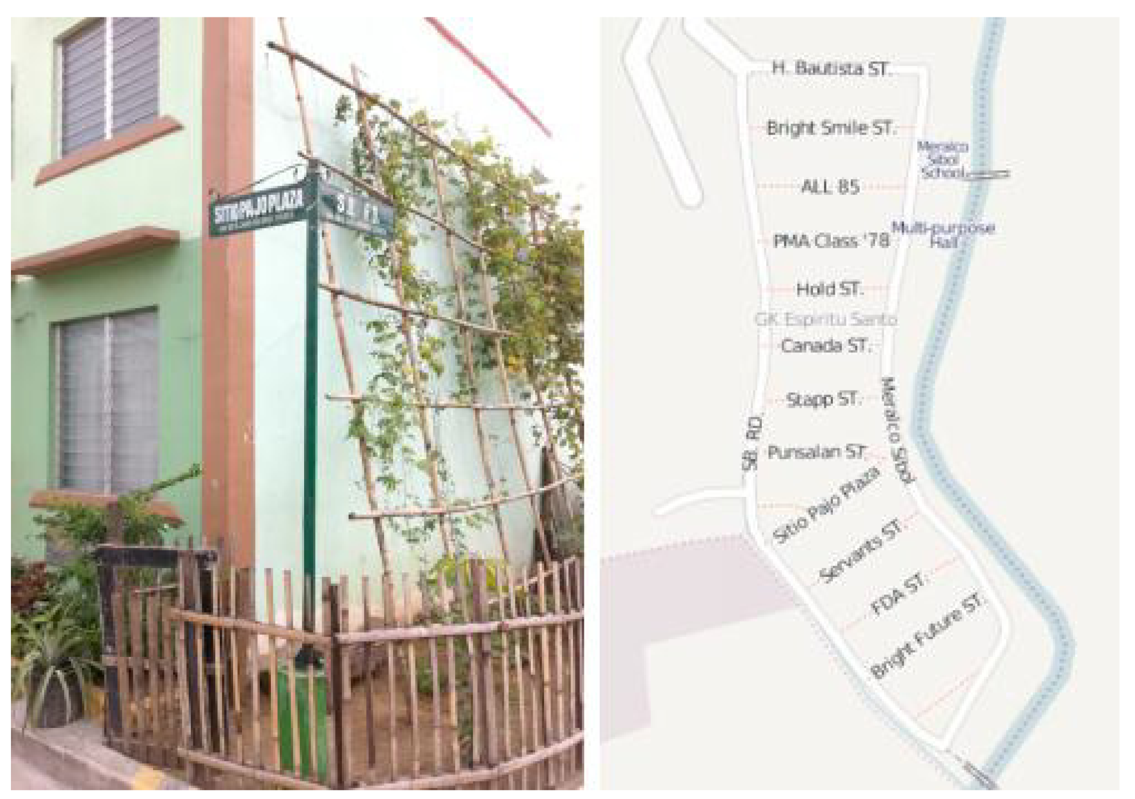
In 2010 we worked on GK village Espiritu Santo, one of our study sites “where the streets have no name” [3]. In the meantime street names had been assigned and we were able to update the data on OSM (Figure 7b). No records of these new street names were available, only in the field we could check and document them.
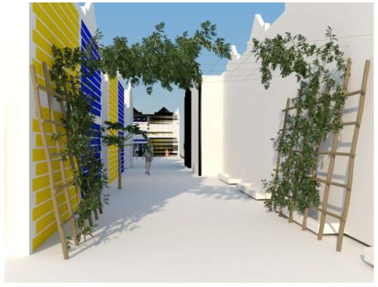
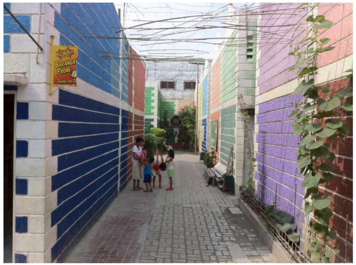
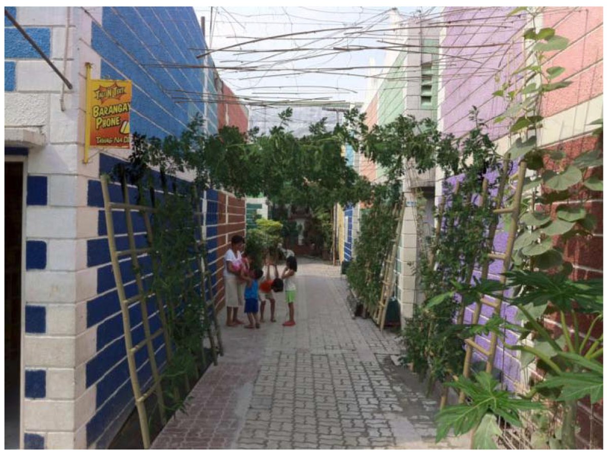
Beside the street name signs, the photo (Figure 6a) shows the successful local implementation of an awarded design intervention: a simple green wall, proposed by one of our MLA students in 2010 [10]. In 2011, a single photo on Flickr [24] mentioning GK village Concepcion helped us to locate the urban quarter but did not come with geo-coordinates. Finally, we were able to find and map the site (Figure 8).
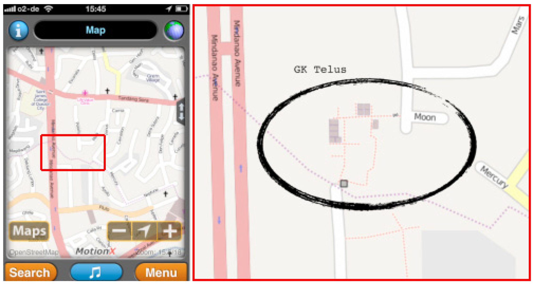
The authors might be two of the few academics in the field of landscape architecture who dedicate their research and design work to informal settlements in the megacity context. At large, we are only two scattered “foot soldiers” in the vast world army of “volunteer geographers” [18], exploring untrodden paths of urban public realm and (re)mapping the world on own initiative [3]. In 2011 in GK village Telus (Figure 9), we were joined by two of these activists, Emmanuel Sambale – a professional geographer and GIS expert, and Rally de Leon, a businessman, running a messenger service in Manila and being frustrated by the ambiguous delivery addresses of many clients.
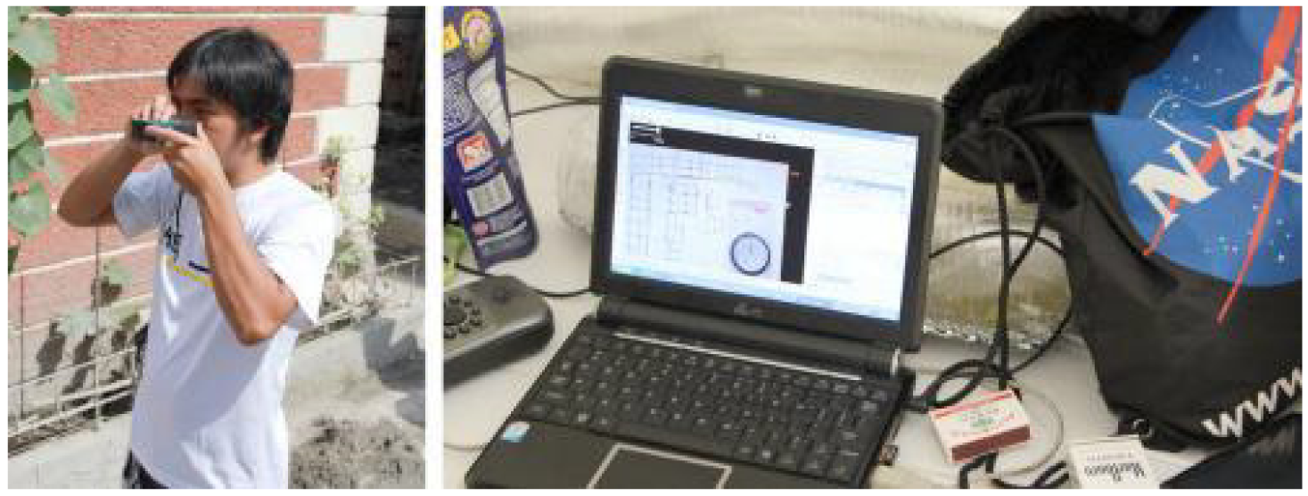
It was them who established the contact, identifying us by our year 2010 OSM uploads of Baseco (Figure 6b). They are volunteer mappers since more than five years, and they joined us during our mapping activities in GK Telus, Quezon City. When they usually do their fieldwork, they celebrate mapping parties. The social part of such parties begins, when all data of a site are collected, processed and uploaded – the same day. They came well equipped – laptop with wireless connection, Garmin GPS tablet devices, laser telemeter and a separate compass (Figure 10). The telemeter was an indoor device and turned out to be not really suitable for outdoor conditions and distances.
Their compass came into operation when using a detailed hand-drawn ground plan of our NUS students to merge it with GPS tracks and a rough ground sketch of their own. The compass was positioned on the paper map, digitally photographed, loaded into JOSM and scaled and rotated with the JOSM plug-in Piclayer (Figure 10b). The GPS data was edited in Garmin's desktop software MapSource and imported into JOSM. After a manual calibration of the laser telemeter data, GPS data and the paper maps, they generated an on-screen fair drafting in JOSM, added useful attributes and were ready to upload the new map tiles. The principle of gathering, processing and upload of all data on one day and on-site, offers an essential advantage: Mistakes or doubts can immediately be checked in situ.
MotionX GPS is a powerful App, but the power consumption of the built-in iPhone GPS receiver is high and sub-street-level accuracy of such standard GPS chips in “urban canyons” is low. The segmentation and narrowness of the informal city does not correspond to such a GPS signal variance and vice versa. To get more than 8–10 m accuracy we would have to move to a differential GPS system. The Filipino OSM volunteers reported that they sometimes use an external antenna in the urban context, mounting it on a bamboo stick to receive better GPS signals. When mapping in areas of high housing density, they recommended setting some reference points in open areas adjacent to these density zones in order to process data with higher accuracy. Elevation measurement from the iPhone 4 was frequently found unreliable and imprecise, i.e., useless.
Telus village does not have street names so far, but house numbers had been assigned recently and could be attributed in OSM. This final step would mean: Telus village is findable, people can be visited, mail can be delivered – mission completed [12].
After their session in Telus, the Filipino colleagues went straight to the next nearby GK village. GK officials showed vivid interest in the community mapping and crowdsourcing approach, and we are pleased that we could initiate a meeting of local actors for a good cause. The uploaded material of Sambale and de Leon (Figure 9) forms a small step of progress concerning our work for GK. They included some samples of the tiny GK house footprints – each footprint is about 18 square meters. This detailed scale just could be reached by including the hand drawings of our MLA students and the (non-georeferenced) lot plan of the GK village (Figure 2); pure GPS mapping does not allow this specificity, and accuracy.Displayed at highest OSM zoom level, we realize that the house samples are nearly too small for such maps, but they are visible. The very small housing lots of GK slum upgrading projects would require a bigger zoom scale of the OSM map renderer (Mapnik). We would like to add more and more details to the OSM platform, but as yet closely located Points of Interest are hardly distinguishable and being labeled visibly.
Not only free and open maps are getting more and more accurate, complete, and recent: e.g., Baseco on Google Maps has recently being updated [25]. Interestingly, this was also done by volunteers but using Google's map maker [26].
3.2. Photographic Documentation
First of all we must explain that this kind of fieldwork, especially taking pictures and bringing curious students into such environment, is only feasible and responsible because of the high reputation and active shelter of GK. Inside the GK villages and even at the fringes one feels safe and very welcome.
In 2010, we have tried to cover entire slum upgrading areas. This systematic photo documentation turned out to be a complicated undertaking, e.g., Baseco has a dimension of several hectares. Many situations in the narrow lanes required acrobatic climbing to allow overlapping image shots – the precision of the attained image material is accordingly limited. Together with all the photos and sketches of the students, the field works creates gigabytes of snapshots and raw image material for the design process and Grassroots GIS. Freehand photographing without tripod is fast, flexible and adequate in narrow and congested slum environments. But the gained material is difficult to process automatically for linear panoramas, because of irregular picture intervals and shooting angles. In 2011, we decided to be more selective and just documented parts that deserved closer attention for design interventions. The iPhone App 360 Panorama allowed us – via an ingenious real-time panorama painting technique – to create on-site, effective geo-referenced 360° views (Figure 11) despite the omnipresent hindrances and stumbling blocks in the informal environment, which render all too systematic and exact photo documentations virtually impossible. No chance for finicky fiddling on squatter or ex-squatter territory. The tightness and density of informal settlements would afford an ultra-wide-angle lens to allow photographing of complete facades – currently unaccomplishable for an iPhone-sized camera. Also the photo quality suffers from high image contrast or in low light conditions. We repeatedly thought that an App with a comparable comfort and simplicity for the creation of linear (long and flat) panoramas would be extremely helpful for analytic work in the context of informal settlements. The 360 Panorama App is one of the most simple and efficient fieldwork tools we found so far, but it should feature a better exposure compensation for strong light contrast in outdoor situations. And it would be good – especially for landscape architects – if the App could record a bigger visible portion of sky and ground.
In 2012, we consider to test Microsoft Photosynth App [17] for the interactive panorama capture and sharing on the cloud. The multi-perspective street slide panorama system Street Slide [27] developed by Microsoft Research is able to render linear panoramas of street façades. We tag our current results as “Google Street View surrogate”, a low-budget, self-made alternative to Street View, wildly handmade but sufficient and bridging the waiting time for the Google (or Microsoft) camera vehicle that never arrives [3].
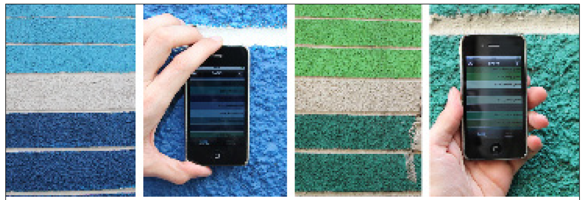
As being visible on the panoramas, color plays a crucial role in the GK concept. Slums are dark, sometimes pitch-black. The GK movement tries to guide the poor back to the light and paints all new houses in bright colors. To document these colors, we used the App Color Set (Figure 12), a digital color chart based on the German RAL color systems, which can be used in the field to identify the exact tint of the GK house walls. Such detailedness is possible but constitutes a theoretical extreme of Grassroots GIS. This goes too far concerning our purposes but we had to test it.
3.3. 3D Modeling and Visualization
The georeferenced iPhone photos can be placed in Google Earth or Biosphere3D – communicating snapshots of the reality and development of GK villages worldwide. In 2010, we have also created sandbox models of photo-textured SketchUp mock-ups for the outdoor design process in Baseco (Figure 13).
These boxes evidently do not work well for overview perspectives. Therefore in 2011, we decided to create true 3D models for interactive visualization. The inchoate 3D model of MLA students' design proposal in GK Telus is based on a rough Google SketchUp model (Figure 14), a georeferenced iPhone photo (Figure 15), and detailed 3D plant models (Figures 14, 16).
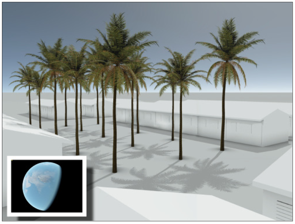
Although 3D trees have been introduced to the popular archetype Google Earth in 2010, this 3D feature is currently available for 50 tree species only and not for other plant types and vegetation cover [28]. Compared to our plant models the degree of detail and realism of Google's plants is too low for convincing foreground display. Chosen vegetation for microgardens and microdesign must be recognizable by the dwellers and potential sponsors of slum-upgrading projects.
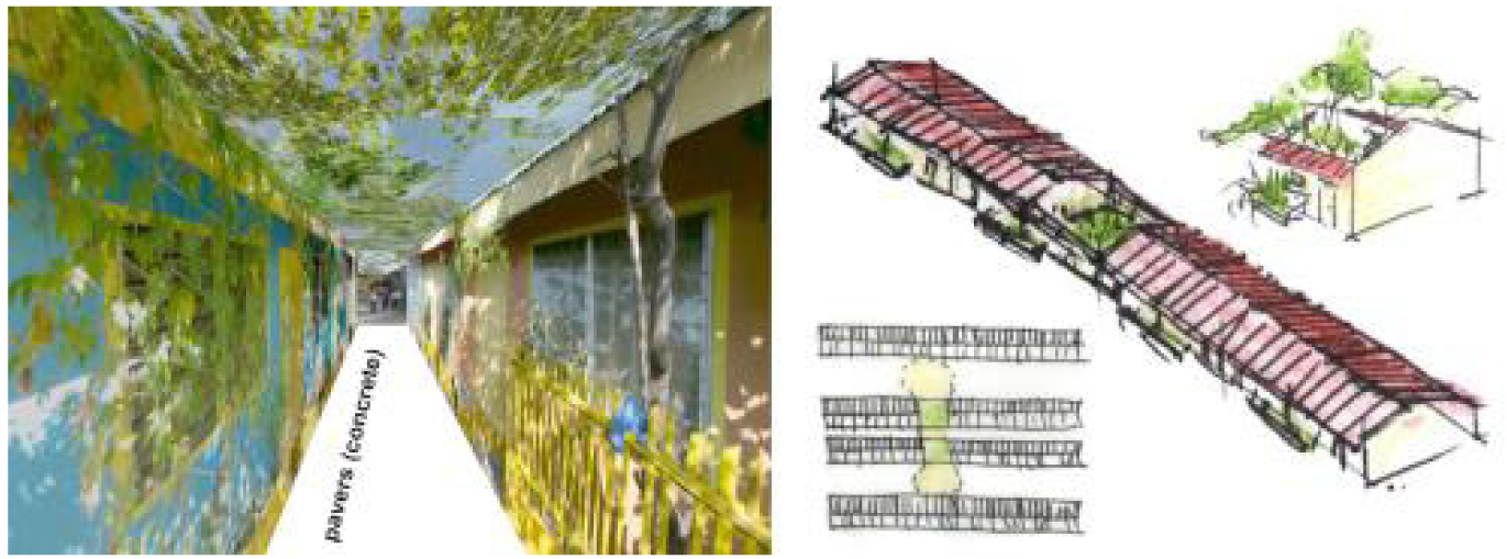
Furthermore, georeferenced 3D models of project areas and design proposals can be placed on a digital globe to add geographical and spatial identity and comprehensiveness to the otherwise untraceable informal worlds in the “haystack” of the megacity. The possibility to fly to new addresses and entries on the digital globe promises to sharpen the sense of orientation and space. The depicted example (Figure 17) represents the described working step in a schematic and symbolic way. Visualized designs in the informal urban context, finally should not look soulless but presumably epitomize a form of dirty imagery [29], being in line with the rough and unadorned face of urban reality.
4. Conclusions
The staggering mega-urban environments of the poorest of the poor have been used as a worst-case laboratory to test state-of-the-art smartphones and their geo-related applications on-site for their capability of delivering adequate geo-data and providing socially and design relevant services. Working in the field of informal urban settlements and slum upgrading projects offers a multitude of opportunities for landscape architects to go back to some essential contents of the profession [3,4]. In a universe next door, there is an overwhelming and fascinating potential of information gathering and design work, which is as yet nearly untouched by landscape architecture. While the comfortable, affluent side of the urbanized planet seems to be buried under all thinkable sorts of information and information overload, the other, uncomfortable side of the coin seems to remain a blind spot in the global consciousness.
Conducting this research parallel to the guidance of design studios with a social background has been an actual challenge. Therefore, we regard this article as a reflection on methods, experiences, problems, necessities and ideas. After the two research trips to Manila, the chosen approach of Grassroots GIS with simple fieldwork tools based on common technology can be found adequate. We have learned four essential lessons; (i) Low-cost mapping tools and free and open platforms such as OpenStreetMap are essential to operate in urban informal settlements, i.e., to become independent from non-existent maps. There are many urban sites that have not yet been sufficiently mapped or mapped at all, where, e.g., aerial photos and street maps on Bing Maps or Google Maps are not up to date or too coarse-grain; (ii) Simple fieldwork tools and methods have proven to be efficient and practicable in terms of mapping speed and data quality on both street map(ping) scale and for photographical documentation; (iii) Precision has it is price. There are tasks such as accurate leveling or measurements with accuracy superior to standard GPS that simply cannot yet be achieved with smartphones and Apps; (iv) OpenStreetMap and standard GPS reach their limits on a street map scale. An adequate scale for outdoor design, especially in narrow and fragmented urban informal settlements would require a mapping and dissemination platform on cadastre level, e.g., up to 1:500.
Grassroots GIS is an effort towards geo-referenced landscape design for the real world [11], e.g., making use of Web 2.0 technology, which seems definitely callow enough to be pursued. Compared to the efforts and outcome of Map Kibera and for the short term, measurable results such as our own map uploads and edits to OSM are certainly marginal. Anecdotal evidence of Baseco suggests that blank spots on the (e.g., OSM or Google) map disappear when volunteer geographers pioneer on these sites. The mediated collaboration between volunteer geographers and a slum-upgrading project has been recognized as a win-win situation and should definitely be adopted by more projects. Apparently, the success of GK projects greatly relies on their trial and error approach and their ability to learn from best practice examples adapting these to local conditions and needs.
To “spread the word”, we seek to publish findings of Grassroots GIS as a kind of hands-on tutorials in a GK Field Manual [5]. Then, a substantial evaluation of our Grassroots GIS approach, e.g., to assess which methods were successfully adopted by other slum-upgrading projects, would be expedient. This could involve comparison of mapping and editing activities on OSM for GK sites. For the time being, the authors plan to refine the Grassroots GIS approach in further case studies to develop a more robust, rigorous methodology. Again, students will be involved in the mapping process and as first users of the processed geo-information within their design work.
Commercial GIS software vendors and commercial providers of online maps do not seem to be unimpressed by the success of platforms and movements such as OpenStreetMap. OSM project founder Steve Coast announced [29] that he has joined Microsoft to work on its Bing Maps team. According to Coast, Microsoft will be providing access to its “global orthorectified aerial imagery to help OpenStreetMappers make the map even better than it already is” [30]. Hopefully, GIS vendors such as Esri Inc. or global players such as Google will continue to increase their engagement for NGOs, and volunteers.
In general, the iPhone with its integrated and expandable functions has proved be useful and appropriate in the extreme urban environment. The simpleness of the fieldwork action leaves room for identification and appreciation of the homemade details in the tinkered worlds of informal settlements. This ability is crucial for the development of context and user related designs – we are neither coming as geographers nor as helpers. We are coming as outdoor designers [3]. We regard our research as design-oriented basic service, paving the way for subsequent outdoor design inclusive planting design, integrating 2D and 3D geospatial data and tools for the purpose of landscape design activities. Professional geodesists have definitely more sophisticated methods and tools.
We will continue to explore the next generation of smartphone devices and Apps and consider to make at least partial use of more professional surveying tools for areas and issues where more precision and accuracy is required, e.g., in flood-prone situations. We might have to seek the company of field surveyors, respectively their hand-held machinery or upgrade on the post-processing of data, e.g., using photo-based 3D modeling software.
One could argue that in slums expensive gadgets like the iPhone are out of place (Figure 18). The decision to upgrade from separate GPS device and budget digital camera was related to three estimations [11]: (i) The growing market share and sinking price of such high-capacity smartphones seems to allow their future subsumption under the grassroots category. They will find their way even into the hands of the poor or already found to some volunteers and local officials in slum-upgrading projects. In our research we are trying to anticipate this inevitable development; (ii) We constantly have to cater for not being outdistanced and compromised by the common technical progress; (iii) Smartphone and “App”-developers lay claim to deliver this legendary all-in-one, the jack of all trades. Even the quarter of fulfillment of this promise would accommodate us very much with our intended grassroots approach.
Power-saving tablet computers such as the Apple iPad with its large display would certainly be helpful for on-site mapping, editing, visualization, and presentation. On the other hand, it seems far too large for a discreet capture of photos. Pulling out a camera can already lead to serious trouble in slum areas; in Manila nobody caries a camera, which substantiates that technical equipment can not be minimized enough. Megaurbanity would call for an “Urban Chaos App”, able to record and analyze the overwhelming mixture of multiple noise, stench of excrements and waste, extreme air pollution, numbing exhaust fumes and other “abstract environmental pollution” [31] on-site. Would an App or cloud service that deliver image-based 3D reconstructions in standard formats, generated in real-time during fieldwork walk-throughs also fall under this muser category?
A true grassroots approach will always necessitate hand- and fieldwork. Most of the findings of our Grassroots GIS approach can therefore just be generated via arduous fieldwork, only be “perceived through the feet” [32]. Under these conditions learning by doing remains indispensable, disappointment inescapable.


Acknowledgments
This study is funded by the School of Design and Environment, Department of Architecture, National University of Singapore (NUS). The authors would like to thank Roma Padua from Gawad Kalinga and the OpenStreetMap volunteers Emmanuel Sambale and Rally de Leon, Manila.
References
- United Nations Human Settlements Programme (UN-HABITAT). The Challenge of Slums: Global Report on Human Settlements 2003; UN-HABITAT: Nairobi, Kenya, 2003. [Google Scholar]
- Davis, M. Planet of slums; Verso: London, UK, 2007. [Google Scholar]
- Rekittke, J.; Paar, P. Grassroots GIS – Digital Outdoor Designing Where the Streets Have No Name. In Peer-reviewed Proc. Digital Landscape Architecture 2010; Buhmann, E., Pietsch, M., Kretzler, E., Eds.; Wichmann: Heidelberg, Germany, 2010; pp. 69–78. [Google Scholar]
- Beardsley, J.; Werthmann, C. Dirty Work. Topos 2008, 64, 36–42. [Google Scholar]
- Building Communities to End Poverty, Available online: http://www.gk1world.com (accessed on 27 June 2011).
- Dumiak, M. The place that wasn't there. Wired UK 2011, 5, 50. [Google Scholar]
- OpenStreetMap (OSM). Available online: http://www.openstreetmap.org (accessed on 27 June 2011).
- Demographia World Urban Areas (World Agglomerations), 7th ed. 2011. Available online: http://www.demographia.com/db-worldua.pdf (accessed on 27 June 2011).
- Burdett, R., Sudjic, D., Eds.; The Endless City: the Urban Age Project by the London School of Economics and Deutsche Bank's Alfred Herrhausen Society; Phaidon Press: New York, NY, USA, 2007.
- Rekittke, J., Ed.; Logbook Landscape Architecture no.02; epubli: Berlin, Germany, 2010; p. 654.
- Papanek, V. Design for the Real World. Human Ecology and Social Change; Academy Chicago Publishers: Chicago, IL, USA, 2000. [Google Scholar]
- Rekittke, J.; Paar, P. There is no App for that—Arduous fieldwork under mega urban conditions. In Teaching Landscape Architecture; Buhmann, E, Ervin, S., Tomlin, C.D., Pietsch, M., Eds.; Anhalt University: Dessau and Bernburg, Germany, 2011; pp. 26–36. [Google Scholar]
- OpenStreetMaps. Metro Manila. Available online: http://www.openstreetmap.org/?lat=14.6122455596924&lon=121.046161651611&zoom=13 (accessed on 19 September 2011).
- Giusti de Pérez, R.; Pérez, R. Analyzing Urban Poverty. GIS for the Developing World; ESRI Press: Redlands, CA, USA, 2008. [Google Scholar]
- d'Oleire-Oltmanns, S.; Coenradie, B.; Kleinschmit, B. An Object-Based Classification Approach for Mapping Migrant Housing in the Mega-Urban Area of the Pearl River Delta (China). Remote Sens. 2011, 3, 1710–1723. [Google Scholar]
- Zandbergen, P.A. Accuracy of iPhone Locations: A Comparison of Assisted GPS, WiFi and Cellular Positioning. Trans. GIS 2009, 13, 5–25. [Google Scholar]
- App Store. Available online: http://www.apple.com/iphone/apps-for-iphone/ (accessed on 2 January 2011).
- Goodchild, M.F. Citizens as Sensors: The World of Volunteered Geography. GeoJournal 2007, 69, 211–221. [Google Scholar]
- Java OpenStreetMap Editor (JOSM). Available online: http://josm.openstreetmap.de/ (accessed on 27 June 2011).
- MotionX-GPS. Available online: http://gps.motionx.com/iphone/overview/ (accessed on 2 January 2011).
- Paar, P.; Clasen, M. Earth, Landscape, Biotope, Plant. Interactive visualisation with Biosphere3D. Proceedings of CORP, 12th International Conference on Urban Planning & Regional Development in the Information Society, Vienna, Austria, 20–23 May 2007; CORP: Vienna Austria; pp. 207–214.
- Rekittke, J.; Paar, P. Digital Botany. J. Landsc. Archit. 2006, 2, 28–35. [Google Scholar]
- Rekittke, J.; Paar, P. Real-time Collage in Landscape Architecture. In Digital Design in Landscape Architecture; Buhmann, E., Pietsch, M., Heins, M., Eds.; Wichmann: Heidelberg, Germany, 2008; pp. 88–95. [Google Scholar]
- GK Build at Buayang Bato. GK RFM Concepcion Village. Available online: http://www.flickr.com/photos/twistedgrooves/404311280/ (accessed on 27 June 2011).
- Google Maps. Baseco Compound. Available online: http://maps.google.com/maps?hl=en&ll=14.593343,120.95973&spn=0.020101,0.016372&t=h&z=16 (accessed on 27 June 2011).
- Google. map maker. Available online: http://www.google.com/intl/en_us/help/mapmaker/ (accessed on 27 June 2011).
- Kopf, J.; Chen, B.; Szeliski, R.; Cohen, M. Street Slide: Browsing Street Level Imagery. ACM Trans. Graph. 2010, 4, 96:1–96:8. [Google Scholar]
- Google. Google Earth Showcase 3D Trees, Available online: http://www.google.com/earth/explore/showcase/trees.html (accessed on 27 June 2011).
- Rekittke, J.; Paar, P. Dirty Imagery – The Challenge of Inconvenient Reality in 3D Landscape Representations. In Peer-reviewed Proc. Digital Landscape Architecture 2010; Buhmann, E., Pietsch, M., Kretzler, E., Eds.; Anhalt University of Applied Sciences: Heidelberg, Germany, 2010; pp. 221–230. [Google Scholar]
- Twitter post. Steve Coast. Available online: http://twitter.com/#!/SteveC/status/7116536766533633 (accessed on 27 June 2011).
- Speed, C.; Southern, J. 2010: Handscapes – Reflecting upon the Use of Locative Media to Explore Landscapes. In Peer-reviewed Proc. Digital Landscape Architecture 2010; Buhmann, E., Pietsch, M., Kretzler, E., Eds.; Anhalt University of Applied Sciences: Heidelberg, Germany, 2010; pp. 164–172. [Google Scholar]
- Ingold, T. Culture on the Ground: The World Perceived Through the Feet. J. Mater. Cult. 2004, 9, 315–340. [Google Scholar]
© 2011 by the authors; licensee MDPI, Basel, Switzerland. This article is an open access article distributed under the terms and conditions of the Creative Commons Attribution license (http://creativecommons.org/licenses/by/3.0/).
Share and Cite
Paar, P.; Rekittke, J. Low-Cost Mapping and Publishing Methods for Landscape Architectural Analysis and Design in Slum-Upgrading Projects . Future Internet 2011, 3, 228-247. https://doi.org/10.3390/fi3040228
Paar P, Rekittke J. Low-Cost Mapping and Publishing Methods for Landscape Architectural Analysis and Design in Slum-Upgrading Projects . Future Internet. 2011; 3(4):228-247. https://doi.org/10.3390/fi3040228
Chicago/Turabian StylePaar, Philip, and Jörg Rekittke. 2011. "Low-Cost Mapping and Publishing Methods for Landscape Architectural Analysis and Design in Slum-Upgrading Projects " Future Internet 3, no. 4: 228-247. https://doi.org/10.3390/fi3040228