
Tools for Assessing the Impacts of Climate Variability and Change on Wildfire Regimes in Forests


 ,
,
Abstract
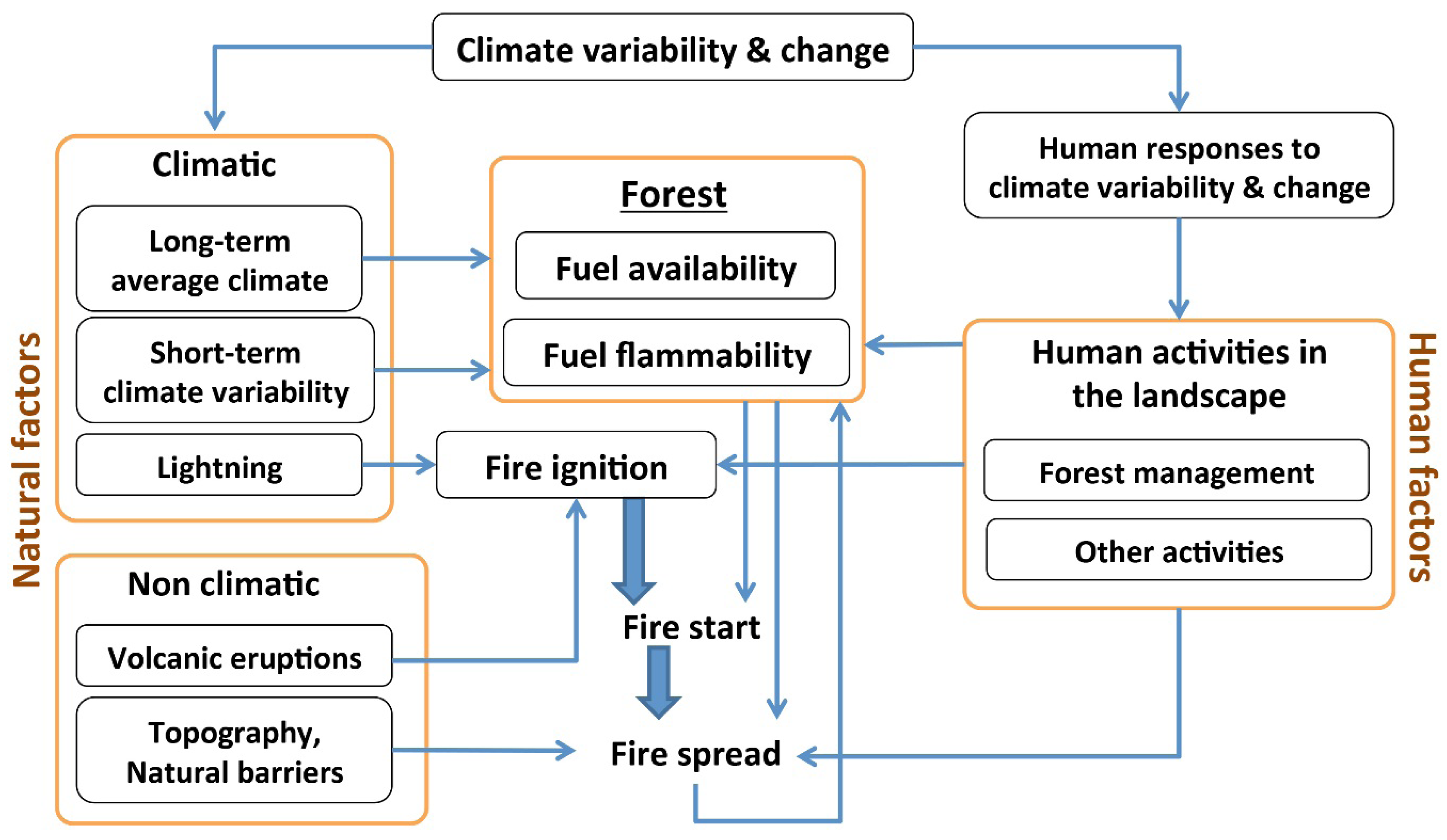
:1. Introduction
2. Remote Sensing Approaches: Monitoring and Mapping Fires and Fuel Characteristics

| Sensor | Spatial Resolution | Temporal Resolution | Study Area | Analyzing, Monitoring and/or Mapping | Product Features | Area Coverage | Sources/Reference | |||
|---|---|---|---|---|---|---|---|---|---|---|
| Active Fires | Burned Areas | Fuel Availability | Fuel Flammability | |||||||
| NOAA-AVHRR | 1000 m | 1 day | Australia, Brazil, Central Africa, Indonesia, Mediterranean, North America, North and South Korea, Russia | √ | √ | √ | √ | Multispectral optical data, 6 bands. Red and near-infrared bands (NDVI) | Large | [26,27,28,29,31,32,33,34,35,36,37,38,39] |
| RapidEye | 5 m | 1 day | Germany, Indonesia, USA | √ | √ | √ | Multispectral optical data, 5 bands (400–850 nm) | Small | [40,41,4243] | |
| AVIRIS | 15–20 m | User defined | USA | √ | √ | Hyperspectral optical data, 220 bands. Visible, near-infrared to shortwave infrared spectral band | Small to medium | [37,39,44,45] | ||
| Landsat TM/ETM | 15–60 m | 16 days | Brazil, France, Greece, Indonesia, Portugal, Spain, USA | √ | √ | √ | √ | Multispectral optical data, 7 bands. Red and near-infrared bands, thermal band | Small to medium | [26,37,39,46,47,48,49,50,5152] |
| MODIS | 250–1000 m | 1-2 days | Africa, Australia, Brazil, Canada, Indonesia, Russia, Spain, USA | √ | √ | √ | √ | Multispectral optical data, 36 bands. Availability of active fire and burned areas products | Medium to large | [37,39,50,53,54,55,56,57,58,59,60,6162] |
| BIRD | 370 m | User defined | Australia, Benin, China, India, Indonesia | √ | Mid-infrared band (MIR)=3.4–4.2 μm; Visible and infrared sensor (VIS) = 0.60–0.67 μm; thermal infrared band (TIR) = 8.5–9.3 μm; near-infrared band (NIR) = 0.84–0.90 μm | Small to medium | [52,56,63,64] | |||
| ASTER | 15–90 m | 4-16 days | Brazil, Greece, Southern Africa, USA | √ | √ | √ | Multispectral optical data, 14 bands. Visible and near-infrared, shortwave infrared, thermal infrared | Small to medium | [39,54,61,65,6667] | |
| MASTER | 5–50 m | User defined | USA | √ | √ | √ | 50 bands (0.4–13 μm), (Visible and near-infrared (VNIR), shortwave infrared (SWIR), mid-infrared (MIR) and thermal infrared (TIR)) | Small to medium | [68,69] | |
| Ikonos | 1 m | 3–5 days (off nadir) | Greece | √ | √ | √ | Multispectral optical data | Small | [70] | |
| ERS SAR | 25 m | 35 days | Canada, France, Greece, Indonesia, Spain, USA | √ | √ | √ | Synthetic aperture radar | Small to medium | [33,46,71,72,73,74,75] | |
| Airborne LIDAR | 0.5 m | User defined | Germany, Indonesia, Portugal, Spain, USA | √ | √ | Laser scanner, capability to be integrated for modeling fire behavior | Small | [25,76,77,78,79,80,8182] | ||
| Data Set | Time Span | Satellite | Spatial Resolution | Temporal Resolution | Status |
|---|---|---|---|---|---|
| GFED3 | 1996–present | MODIS, TRMM/VIRS, ATSR | 0.5° × 0.5° | Monthly | Operational |
| MCD45A1 | 2000–2009 | MODIS | 500 m | Monthly | Operational |
| L3JRC | 2000–2007 | SPOT VEGETATION | 1 km | Daily | Finished |
| GBA2000 | 2000 | SPOT VEGETATION | 1 km | Monthly | Finished |
| GLOBCARBON | 1998–2007 | SPOT VEGETATION, ATSR-2, AATSR | 1 km | Monthly | Finished |
| GBS | 1982–1999 | NOAA-AVHRR GAC | 8 km | Weekly | Finished |
| GLOBSCAR | >2000 | ERS2-ATSR2 | 1 km | Monthly | Finished |
3. Dynamic Global Vegetation and Landscape Models
4. Modeling Fuel Characteristics and Fire: Integrated Fire-Vegetation Models
5. Modeling Dynamics of Fuel Flammability: Fire Danger Rating Systems
6. Modeling Fire Ignition and Occurrence: Empirical Models
7. Modeling Fuel Flammability, Fire Occurrence, Spread and Effects: Fire Models
8. Conclusions
Acknowledgments
Author Contributions
Glossary
Conflicts of Interest
References
- Trabaud, L. Postfire plant community dynamics in the Mediterranean basin. Ecol. Stud. 1994, 107, 1–15. [Google Scholar]
- Velez, R. Mediterranean forest fires: A regional perspective. Unasylva 1990, 162, 10–12. [Google Scholar]
- Alo, C.A.; Wang, G.L. Potential future changes of the terrestrial ecosystem based on climate projections by eight general circulation models. J. Geophys. Res.-Biogeosci. 2008, 113, G01004. [Google Scholar] [CrossRef]
- Krawchuk, M.A.; Moritz, M.A.; Parisien, M.; Dorn, J.V.; Hayhoe, K. Global pyrogeography: The current and future distribution of wildfire. PloS ONE 2009, 4, e5102. [Google Scholar] [CrossRef] [PubMed]
- Liu, Y.; Stanturf, J.; Goodrick, S. Trends in global wildfire potential in a changing climate. Forest Ecol. Manag. 2010, 259, 685–697. [Google Scholar] [CrossRef]
- Moritz, M.A.; Parisien, M.-A.; Batllori, E.; Krawchuk, M.A.; Van Dorn, J.; Ganz, D.J.; Hayhoe, K. Climate change and disruptions to global fire activity. Ecosphere 2012, 3. art49. [Google Scholar] [CrossRef]
- Scholze, M.; Knorr, W.; Arnell, N.W.; Prentice, I.C. A climate-change risk analysis for world ecosystems. PNAS 2006, 103, 13116–13120. [Google Scholar] [CrossRef] [PubMed]
- IPCC Summary for Policymakers. In Climate Change 2013: The Physical Science Basis. Contribution of Working Group I to the Fifth Assessment Report of the Intergovernmental Panel on Climate Change; Stocker, T.; Qin, D.; Plattner, G.; Tignor, M.; Allen, S.; Boschung, J.; Nauels, A.; Xia, Y.; Bex, V.; Midgley, P. (Eds.) Cambridge University Press: Cambridge, UK; New York, NY, USA, 2013; p. 29.
- FAO; GFMC. FAO wildland fire management terminology. Available online: http://www.fire.uni-freiburg.de/literature/glossary.htm (accessed on 9 February 2014).
- Fauria, M.M.; Michaletz, S.T.; Johnson, E.A. Predicting climate change effects on wildfires requires linking processes across scales. Wiley Interdiscip. Rev.: Clim. Chang. 2010, 2, 99–112. [Google Scholar] [CrossRef]
- Flannigan, M.D.; Krawchuk, M.A.; de-Groot, W.J.; Wotton, B.M.; Gowman, L.M. Implications of changing climate for global wildland fire. Int. J. Wildland Fire 2009, 18, 483–507. [Google Scholar] [CrossRef]
- Cardille, J.A.; Ventura, S.J.; Turner, M.G. Environmental and social factors influencing wildfires in the Upper Midwest, USA. Ecol. Appl. 2001, 11, 111–127. [Google Scholar] [CrossRef]
- Genton, M.G.; Butry, D.T.; Gumpertz, M.L.; Prestemon, J.P. Spatio-temporal analysis of wildfire ignitions in the St Johns River Water Management District, Florida. Int. J. Wildland Fire 2006, 15, 87–97. [Google Scholar] [CrossRef]
- Agee, J.; Skinner, C. Basic principles of forest fuel reduction treatments. For. Ecol. Manag. 2005, 211, 83–96. [Google Scholar] [CrossRef]
- Dimitrakopoulos, A. A statistical classification of Mediterranean species based on their flammability components. Int. J. Wildland Fire 2001, 10, 113–118. [Google Scholar] [CrossRef]
- Schoenberg, F.; Peng, R.; Huang, Z.; Rundel, P. Detection of non-linearities in the dependence of burn area on fuel age and climatic variables. Int. J. Wildland Fire 2003, 12, 1–6. [Google Scholar] [CrossRef]
- Allen, C.D. Cross-scale interactions among forest dieback, fire, and erosion in northern New Mexico landscapes. Ecosystems 2007, 10, 797–808. [Google Scholar] [CrossRef]
- Woodall, C.W.; Nagel, L.M. Down woody fuel loadings dynamics of a large-scale blowdown in northern Minnesota. For. Ecol. Manag. 2007, 247, 194–199. [Google Scholar] [CrossRef]
- González, J.; Trasobares, A.; Palahi, M.; Pukkala, T. Predicting stand damage and tree survival in burned forests in Catalonia (North-East Spain). Ann. For. Sci. 2007, 64, 733–742. [Google Scholar] [CrossRef]
- Pollet, J.; Omi, P.N. Effect of thinning and prescribed burning on crown fire severity in ponderosa pine forests. Int. J. Wildland Fire 2002, 11, 1–10. [Google Scholar] [CrossRef]
- Goldammer, J.G.; Price, C. Potential impacts of climate change on fire regimes in the tropics based on MAGICC and a GISS GCM-derived lightning model. Clim. Chang. 1998, 39, 273–296. [Google Scholar] [CrossRef]
- Wotton, B.M.; Martell, D.L.; Logan, K.A. Climate change and people-caused forest fire occurrence in Ontario. Clim. Chang. 2003, 60, 275–295. [Google Scholar] [CrossRef]
- Pausas, J.G.; Bradstock, R.A. Fire persistence traits of plants along a productivity and disturbance gradient in mediterranean shrublands of south-east Australia. Glob. Ecol. Biogeogr. 2007, 16, 330–340. [Google Scholar] [CrossRef]
- Lavorel, S.; Flannigan, M.D.; Lambin, E.F.; Scholes, M.C. Vulnerability of land systems to fire: Interactions among humans, climate, the atmosphere, and ecosystems. Mitig. Adapt. Strateg. Glob. Chang. 2007, 12, 33–53. [Google Scholar] [CrossRef]
- González-Olabarria, J.R.; Rodríguez, F.; Fernández-Landa, A.; Mola-Yudego, B. Mapping fire risk in the Model Forest of Urbión (Spain) based on airborne LiDAR measurements. For. Ecol. Manag. 2012, 282, 149–156. [Google Scholar] [CrossRef]
- Dennis, R.A.; Maye, J.; Applegate, G.; Chokkalingam, U.; Colfer, C.J.P.; Kurniawan, I.; Lachowski, H.; Maus, P.; Permana, R.P.; Ruchiat, Y.; et al. Fire, people and pixels: Linking social science and remote sensing to understand underlying causes and impacts of fires in Indonesia. Hum. Ecol. 2005, 33, 465–504. [Google Scholar] [CrossRef]
- Chuvieco, E.; Cocero, D.; Riano, D.; Martin, P.; Martınez-Vega, J.; de-la-Riva, J.; Perez, F. Combining NDVI and surface temperature for the estimation of live fuel moisture content in forest fire danger rating. Remote Sens. Environ. 2004, 92, 322–331. [Google Scholar] [CrossRef]
- Gong, P.; Pu, R.; Li, Z.; Scarborough, J.; Clinton, N.; Levien, L.M. An integrated approach to wildland fire mapping of California, USA using NOAA/AVHRR data. Photogramm. Eng. Remote Sens. 2006, 72, 139–150. [Google Scholar] [CrossRef]
- Sukhinin, A.I.; French, N.H.F.; Kasischke, E.S.; Hewson, J.H.; Soja, A.J.; Csiszar, I.A.; Hyer, E.J.; Loboda, T.; Conrad, S.G.; Romasko, V.I.; et al. AVHRR-based mapping of fires in Russia: New products for fire management and carbon cycle studies. Remote Sens. Environ. 2004, 93, 546–564. [Google Scholar] [CrossRef]
- Tucker, C.J. Red and photographic infrared linear combinations for monitoring vegetation. Remote Sens. Environ. 1979, 8, 127–150. [Google Scholar] [CrossRef]
- Lyon, J.G.; Yuan, D.; Lunetta, R.S.; Elvidge, C.D. A change detection experiment using vegetation indices. Photogramm. Eng. Remote Sens. 1998, 64, 143–150. [Google Scholar]
- Oldford, S.; Leblon, B.; Gallant, L.; Alexander, M.E. Mapping pre-fire forest conditions with NOAA-AVHRR images in northern Boreal forests. Geocarto Int. 2003, 18, 21–32. [Google Scholar] [CrossRef]
- Siegert, F.; Ruecker, G.; Hinrichs, A.; Hoffmann, A.A. Increased damage from fires in logged forests during droughts caused by El Nino. Nature 2001, 414, 437–440. [Google Scholar] [CrossRef] [PubMed]
- Schuck, A.; Brusselen, J.V.; Paivinen, R.; Hame, T.; Kennedy, P.; Folving, S. Compilation of a Calibrated European Forest Map Derived from NOAA-AVHRR Data; European Forest Institute: Joensuu, Finland, 2002; p. 44. [Google Scholar]
- Chung, Y.S.; Kim, H.S. Satellite monitoring of forest fires and associated smoke plumes occuring in Korea. Air Qual. Atmos. Health 2008, 1, 111–118. [Google Scholar] [CrossRef]
- Crevoisier, C.; Shevliakova, E.; Gloor, M.; Wirth, C.; Pacala, S. Drivers of fire in the boreal forests: Data constrained design of a prognostic model of burned area for use in dynamic global vegetation models. J. Geophys. Res. 2007, 112. [Google Scholar] [CrossRef]
- Xie, Y.; Sha, Z.; Yu, M. Remote sensing imagery in vegetation mapping: A review. J. Plant Ecol. 2008, 1, 9–23. [Google Scholar] [CrossRef]
- Li, Z.; Fraser, R.; Jin, J.; Abuelgasim, A.A.; Csiszar, I.; Gong, P.; Pu, R.; Hao, W. Evaluation of algorithms for fire detection and mapping across North America from satellite. J. Geophys. Res. 2003, 108, 4076. [Google Scholar] [CrossRef]
- Joseph, S.; Murthy, M.; Thomas, A. The progress on remote sensing technology in identifying tropical forest degradation: A synthesis of the present knowledge and future perspectives. Environ. Earth Sci. 2011, 64, 731–741. [Google Scholar] [CrossRef]
- Franke, J.; Navratil, P.; Keuck, V.; Peterson, K.; Siegert, F. Monitoring fire and selective logging activities in tropical peat swamp forests. IEEE J. Sel. Top. Appl. Earth Observ. Remote Sens. 2012, 5, 1811–1820. [Google Scholar] [CrossRef]
- Eitel, J.U.; Vierling, L.A.; Litvak, M.E.; Long, D.S.; Schulthess, U.; Ager, A.A.; Krofcheck, D.J.; Stoscheck, L. Broadband, red-edge information from satellites improves early stress detection in a New Mexico conifer woodland. Remote Sens. Environ. 2011, 115, 3640–3646. [Google Scholar] [CrossRef]
- Schuster, C.; Förster, M.; Kleinschmit, B. Testing the red edge channel for improving land-use classifications based on high-resolution multi-spectral satellite data. Int. J. Remote Sens. 2012, 33, 5583–5599. [Google Scholar] [CrossRef]
- RapidEye AG. Satellite Imagery Product Specifications; RapidEye AG and RapidEye US LLC: Brandenburg an der Havel, Germany, 2012; p. 44. [Google Scholar]
- Jia, G.J.; Burke, I.C.; Goetz, A.F.; Kaufmann, M.R.; Kindel, B.C. Assessing spatial patterns of forest fuel using AVIRIS data. Remote Sens. Environ. 2006, 102, 318–327. [Google Scholar] [CrossRef]
- Asner, G.P.; Jones, M.O.; Martin, R.E.; Knapp, D.E.; Hughes, R.F. Remote sensing of native and invasive species in Hawaiian forests. Remote Sens. of Environ. 2008, 112, 1912–1926. [Google Scholar] [CrossRef]
- Chuvieco, E. A Review of Remote Sensing Methods for the Study of Large Wildland Fires; Departamento de Geografía, Universidad de Alcalá: Alcalá de Henares, Spain, 1997; p. 192. [Google Scholar]
- Kerr, J.T.; Ostrovsky, M. From space to species: Ecological applications for remote sensing. Trends Ecol. Evol. 2003, 18, 299–305. [Google Scholar] [CrossRef]
- Lentile, L.B.; Holden, Z.A.; Smith, A.M.S.; Falkowski, M.J.; Hudak, A.T.; Morgan, P.; Lewis, S.A.; Gessler, P.E.; Benson, N.C. Remote sensing techniques to assess active fire characteristics and post-fire effects. Int. J. Wildland Fire 2006, 15, 319–345. [Google Scholar] [CrossRef]
- Alencar, A.A.C.; Solorzano, L.A.; Nepstad, D.C. Modeling forest understory fires in an Eastern Amazonian Landscape. Ecol. Appl. 2004, 14, S139–S149. [Google Scholar] [CrossRef]
- Barrett, K.; Kasischke, E.S.; McGuire, A.D.; Turetsky, M.R.; Kane, E.S. Modeling fire severity in black spruce stands in the Alaskan boreal forest using spectral and non-spectral geospatial data. Remote Sens. Environ. 2010, 114, 1494–1503. [Google Scholar] [CrossRef]
- De Zea Bermudez, P.; Mendes, J.; Pereira, J.M.C.; Turkman, K.F.; Vasconcelos, M.J.P. Spatial and temporal extremes of wildfire sizes in Portugal (1984–2004). Int. J. Wildland Fire 2009, 18, 983–991. [Google Scholar]
- Joseph, S.; Anitha, K.; Murthy, M. Forest fire in India: A review of the knowledge base. Jpn. For. Soc. Springer 2009, 14, 127–134. [Google Scholar]
- Chuvieco, E.; Kasischke, E.S. Remote sensing information for fire management and fire effects assessment. J. Geophys. Res. 2007, 112, G01S90. [Google Scholar]
- Giglio, L.; Descloitres, J.; Justice, C.O.; Kaufman, Y.J. An enhanced contextual fire detection algorithm for MODIS. Remote Sens. Environ. 2003, 87, 273–282. [Google Scholar] [CrossRef]
- Roberts, G.J.; Wooster, M.J. Fire detection and fire characterization over Africa using Meteosat SEVIRI. IEEE Trans. Geosci. Remote Sens. 2008, 46, 1200–1218. [Google Scholar] [CrossRef]
- Wooster, M.J.; Zhukov, B.; Oertel, D. Fire radiative energy for quantitative study of biomass burning: Derivation from the BIRD experimental satellite and comparison to MODIS fire products. Remote Sens. Environ. 2003, 86, 83–107. [Google Scholar] [CrossRef]
- Achard, F.; Eva, H.D.; Mollicone, D.; Beuchle, R. The effect of climate anomalies and human ignition factor on wildfires in Russian boreal forests. Philos. Trans. R. Soc. B 2008, 363, 2329–2337. [Google Scholar] [CrossRef]
- Akther, M.S.; Hassan, Q.K. Remote sensing-based assessment of fire danger conditions over boreal forest. Sel. Top. Appl. Earth Observ. Remote Sens. IEEE J. 2011, 4, 992–999. [Google Scholar] [CrossRef]
- Pricope, N.G.; Binford, M.W. A spatio-temporal analysis of fire recurrence and extent for semi-arid savanna ecosystems in southern Africa using moderate-resolution satellite imagery. J. Environ. Manag. 2012, 100, 72–85. [Google Scholar] [CrossRef]
- Tansey, K.; Beston, J.; Hoscilo, A.; Page, S.E.; Hernandez, C.U.P. Relationship between MODIS fire hot spot count and burned area in a degraded tropical peat swamp forest in Central Kalimantan, Indonesia. J. Geophys. Res. 2008, 113. [Google Scholar] [CrossRef]
- Morisette, J.T.; Giglio, L.; Csiszar, I.; Setzer, A.; Schroeder, W.; Morton, D.; Justice, C.O. Validation of MODIS active fire detection products derived from two algorithms. Earth Interact. 2005, 9, 1–25. [Google Scholar] [CrossRef]
- Giglio, L.; Randerson, J.T.; van der Werf, G.R.; Kasibhatla, P.S.; Collatz, G.J.; Morton, D.C.; DeFries, R.S. Assessing variability and long-term trends in burned area by merging multiple satellite fire products. Biogeosciences 2010, 7, 1171–1186. [Google Scholar] [CrossRef]
- Oertel, D.; Zhukov, B.; Thamm, H.-P.; Roehrig, J.; Orthmann, B. Space-borne high resolution fire remote sensing in Benin, West Africa. Int. J. Remote Sens. 2004, 25, 2209–2216. [Google Scholar] [CrossRef]
- Briess, K.; Lorenz, E. Systematic image processing of the small satellite mission BIRD. Available online: http://fred.unis.no/AGF218/Systematic%20image%20processing%20of%20BIRD%20V2.pdf (accessed on 10 March 2014).
- Falkowski, M.J.; Gessler, P.E.; Morgan, P.; Hudak, A.T.; Smith, A.M.S. Characterizing and mapping forest fire fuels using ASTER imagery and gradient modeling. For. Ecol. Manag. 2005, 217, 129–146. [Google Scholar] [CrossRef]
- Yamaguchi, Y.; Kahle, A.B.; Tsu, H.; Kawakami, T.; Pniel, M. Overview of advanced spaceborne thermal emission and reflection radiometer (ASTER). IEEE Trans. Geosci. Remote Sens. 1998, 36, 1062–1071. [Google Scholar] [CrossRef]
- Keramitsoglou, I.; Kontoes, C.; Sykioti, O.; Sifakis, N.; Xofis, P. Reliable, accurate and timely forest mapping for wildfire management using ASTER and Hyperion satellite imagery. For. Ecol. Manag. 2008, 255, 3556–3562. [Google Scholar] [CrossRef]
- Harris, S.; Veraverbeke, S.; Hook, S. Evaluating spectral indices for assessing fire severity in Chaparral ecosystems (Southern California) using MODIS/ASTER (MASTER) airborne simulator data. Remote Sens. 2011, 3, 2403–2419. [Google Scholar] [CrossRef]
- Hook, S.J.; Myers, J.J.; Thome, K.J.; Fitzgerald, M.; Kahle, A.B. The MODIS/ASTER airborne simulator (MASTER)-a new instrument for earth science studies. Remote Sens. Environ. 2001, 76, 93–102. [Google Scholar] [CrossRef]
- Mitri, G.; Gitas, I. Fire type mapping using object-based classification of Ikonos imagery. Int. J. Wildland Fire 2006, 15, 457–462. [Google Scholar] [CrossRef]
- Bourgeau-Chavez, L.L.; Garwood, G.; Riordan, K.; Cella, B.; Alden, S.; Kwart, M.; Murphy, K. Assessing the potential for wildfire using ERS-2 SAR imagery. Available online: https://www.asf.alaska.edu/news-notes/3-1/wildfire/ (accessed on 9 February 2014).
- Dobson, M.C.; Pierce, L.; Sarabandi, K.; Ulaby, F.T.; Sharik, T. Preliminary analysis of ERS-1 SAR for forest ecosystem studies. IEEE Trans. Geosci. Remote 1992, 30, 203–211. [Google Scholar] [CrossRef]
- Leblon, B.; Kasischke, E.; Alexander, M.; Doyle, M.; Abbott, M. Fire danger monitoring using ERS-1 SAR images in the case of northern Boreal forests. Nat. Hazards 2002, 27, 231–255. [Google Scholar] [CrossRef]
- Siegert, F.; Hoffmann, A.A. The 1998 forest fires in East Kalimantan (Indonesia): A quantitative evaluation using high resolution, multitemporal ERS-2 SAR images and NOAA-AVHRR hotspot data. Remote Sens. Environ. 2000, 72, 64–77. [Google Scholar] [CrossRef]
- Kasischke, E.S.; Bourgeau-Chavez, L.L.; Johnstone, J.F. Assessing spatial and temporal variations in surface soil moisture in fire-disturbed black spruce forests in Interior Alaska using spaceborne synthetic aperture radar imagery—Implications for post-fire tree recruitment. Remote Sens. Environ. 2007, 108, 42–58. [Google Scholar] [CrossRef]
- Andersen, H.-E.; McGaughey, R.J.; Reutebuch, S.E. Estimating forest canopy fuel parameters using LIDAR data. Remote Sens. Environ. 2005, 94, 441–449. [Google Scholar] [CrossRef]
- Mutlu, M.; Popescu, S.C.; Stripling, C.; Spencer, T. Mapping surface fuel models using lidar and multispectral data fusion for fire behavior. Remote Sens. Environ. 2008, 112, 274–285. [Google Scholar] [CrossRef]
- Mutlu, M.; Popescu, S.C.; Zhao, K. Sensitivity analysis of fire behavior modeling with LIDAR-derived surface fuel maps. For. Ecol. Manag. 2008, 256, 289–294. [Google Scholar] [CrossRef]
- Riano, D.; Meier, E.; Allgower, B.; Chuvieco, E.; Ustin, S.L. Modeling airborne laser scanning data for the spatial generation of critical forest parameters in fire behavior modeling. Remote Sens. Environ. 2003, 86, 177–186. [Google Scholar] [CrossRef]
- Riano, D.; Valladares, F.; Condes, S.; Chuvieco, E. Estimation of leaf area index and covered ground from airborne laser scanner (Lidar) in two contrasting forests. Agric. For. Meteorol. 2004, 124, 269–275. [Google Scholar] [CrossRef]
- Riano, D.; Chuvieco, E.; Ustin, S.L.; Salas, J.; Rodríguez-Perez, J.R.; Ribeiro, L.M.; Viegas, D.X.; Moreno, J.M.; Fernandez, H. Estimation of shrub height for fuel-type mapping combining airborne LiDAR and simultaneous color infrared ortho imaging. Int. J. Wildland Fire 2007, 16, 341–348. [Google Scholar] [CrossRef]
- Jubanski, J.; Ballhorn, U.; Kronseder, K.; Franke, J.; Siegert, F. Detection of large above-ground biomass variability in lowland forest ecosystems by airborne LiDAR. Biogeosciences 2013, 10, 3917–3930. [Google Scholar] [CrossRef]
- Blackbridge. Satellite Imagery Product Specifications; Blackbridge: Berlin, Germany, 2012; p. 47. [Google Scholar]
- Irons, J.R.; Dwyer, J.L.; Barsi, J.A. The next landsat satellite: The landsat data continuity mission. Remote Sens. Environ. 2012, 122, 11–21. [Google Scholar] [CrossRef]
- Mouillot, F.; Schultz, M.G.; Yue, C.; Cadule, P.; Tansey, K.; Ciais, P.; Chuvieco, E. Ten years of global burned area products from spaceborne remote sensing-A review: Analysis of user needs and recommendations for future developments. Int. J. Appl. Earth Observ. Geoinf. 2014, 26, 64–79. [Google Scholar] [CrossRef]
- Thonicke, K.; Venevsky, S.; Sitch, S.; Cramer, W. The role of fire disturbance for global vegetation dynamics: Coupling fire into a dynamic global vegetation model. Glob. Ecol. Biogeogr. 2001, 10, 661–677. [Google Scholar] [CrossRef]
- He, H.S.; Hao, Z.; Mladenoff, D.J.; Shao, G.; Hu, Y.; Chang, Y. Simulating forest ecosystem response to climate warming incorporating spatial effects in north-eastern China. J. Biogeogr. 2005, 32, 2043–2056. [Google Scholar] [CrossRef]
- Schumacher, S.; Bugmann, H. The relative importance of climatic effects, wildfires and management for future forest landscape dynamics in the Swiss Alps. Glob. Chang. Biol. 2006, 12, 1435–1450. [Google Scholar] [CrossRef]
- Schumacher, S.; Reineking, B.; Sibold, J.; Bugmann, H. Modeling the impact of climate and vegetation on fire regimes in mountain landscapes. Landsc. Ecol. 2006, 21, 539–554. [Google Scholar] [CrossRef]
- Sitch, S.; Huntingford, C.; Gedney, N.; Levy, P.E.; Lomas, M.; Piao, S.L.; Betts, R.; Ciais, P.; Cox, P.; Friedlingstein, P.; et al. Evaluation of the terrestrial carbon cycle, future plant geography and climate-carbon cycle feedbacks using five dynamic global vegetation models (DGVMs). Glob. Chang. Biol. 2008, 14, 2015–2039. [Google Scholar] [CrossRef]
- Battles, J.J.; Robards, T.; Das, A.; Waring, K.; Gilless, J.K.; Biging, G.; Schurr, F. Climate change impacts on forest growth and tree mortality: A data-driven modeling study in the mixedconifer forest of the Sierra Nevada, California. Clim. Chang. 2008, 87, S193–S213. [Google Scholar] [CrossRef]
- UNFCCC Secretariat. Compendium on Methods and Tools to Evaluate Impacts of, and Vulnerability and Adaptation to Climate Change. Final Draft Report; UNFCCC Secretariat: Bonn, Germany, 2008.
- Sitch, S.; Smith, B.; Prentice, I.; Arneth, A.; Bondeau, A.; Cramer, W.; Kaplan, J.; Levis, S.; Lucht, W.; Sykes, M.; et al. Evaluation of ecosystem dynamics, plant geography and terrestrial carbon cycling in LPJ dynamic global vegetation model. Glob. Chang. Biol. 2003, 9, 161–185. [Google Scholar] [CrossRef]
- Henne, P.D.; Elkin, C.; Colombaroli, D.; Samartin, S.; Bugmann, H.; Heiri, O.; Tinner, W. Impacts of changing climate and land use on vegetation dynamics in a Mediterranean ecosystem: Insights from paleoecology and dynamic modeling. Landsc. Ecol. 2012, 1–15. [Google Scholar]
- Thonicke, K.; Cramer, W. Long-term trends in vegetation dynamics and forest fires in Brandenburg (Germany) under a changing climate. Nat. Hazards 2006, 38, 283–300. [Google Scholar] [CrossRef]
- IPCC. IPCC Special Report. Emissions Scenarios. Summary for Policymakers; WMO, UNEP: Geneva, 2000; p. 20.
- Finney, M.A.; McHugh, C.W.; Grenfell, I.C.; Riley, K.L.; Short, K.C. A simulation of probabilistic wildfire risk components for the continental United States. Stochast. Environ. Res. Risk Assess. 2011, 25, 973–1000. [Google Scholar] [CrossRef]
- Gebert, K.M.; Calkin, D.E.; Huggett, R.J.; Abt, K.L. Economic analysis of federal wildfire management programs. In The Economics of Forest Disturbances: Wildfires, Storms, and Invasive Species; Holmes, T.P., Prestemon, J.P., Abt, K.L., Eds.; Springer-Verlag: Dordrecht, The Netherlands, 2008; pp. 295–322. [Google Scholar]
- Bachelet, D.; Lenihan, J.M.; Daly, C.; Neilson, R.P. Interactions between fire, grazing and climate change at Wind Cave National Park, SD. Ecol. Model. 2000, 134, 229–244. [Google Scholar] [CrossRef]
- Bachelet, D.; Neilson, R.P.; Lenihan, J.M.; Drapek, R.J. Climate change effects on vegetation distribution and carbon budget in the United States. Ecosystems 2001, 4, 164–185. [Google Scholar] [CrossRef]
- Rogers, B.M.; Neilson, R.P.; Drapek, R.; Lenihan, J.M.; Wells, J.R.; Bachelet, D.; Law, B.E. Impacts of climate change on fire regimes and carbon stocks of the U.S. Pacific Northwest. J. Geophys. Res. 2011, 116, G03037. [Google Scholar]
- Gonzalez, P.; Neilson, R.P.; Lenihan, J.M.; Drapek, R.J. Global patterns in vulnerability of ecosystems to vegetation shifts due to climate change. Glob. Ecol. Biogeogr. 2010, 19, 755–768. [Google Scholar] [CrossRef]
- Herrera, S.; Bedia, J.; Gutiérrez, J.M.; Fernández, J.; Moreno, J.M. On the projection of future fire danger conditions with various instantaneous/mean-daily data sources. Clim. Chang. 2013, 118, 827–840. [Google Scholar] [CrossRef]
- Williams, A.A.J.; Karoly, D.K.; Tapper, N. The sensitivity of Australian fire danger to climate change. Clim. Chang. 2001, 49, 171–191. [Google Scholar] [CrossRef]
- White, B.L.A.; White, L.A.S.; Ribeiro, G.T.; Fernandes, P.A.M. Development of a fire danger index for Eucalypt plantations in the northern coast of Bahia, Brazil. Floresta 2013, 43, 601–610. [Google Scholar] [CrossRef]
- Petros, G.; Antonis, M.; Marianthi, T. Development of an adapted empirical drought index to the Mediterranean conditions for use in forestry. Agric. For. Meteorol. 2011, 151, 241–250. [Google Scholar] [CrossRef]
- Flannigan, M.D.; Amiro, B.D.; Logan, K.A.; Stocks, B.J.; Wotton, B.M. Forest fires and climate change in the 21st century. Mitig. Adapt. Strateg. Glob. Chang. 2005, 11, 847–859. [Google Scholar] [CrossRef]
- Le Goff, H.; Flannigan, M.D.; Bergeron, Y. Potential changes in monthly fire risk in the eastern Canadian boreal forest under future climate change. Can. J. For. Res. 2009, 39, 2369–2380. [Google Scholar]
- Nitschke, C.R.; Innes, J.L. Climatic change and fire potential in South-Central British Columbia, Canada. Glob. Chang. Biol. 2008, 14, 841–855. [Google Scholar] [CrossRef]
- Stocks, B.J.; Fosberg, M.A.; Lynham, T.J.; Mearns, L.; Wotton, B.M.; Yang, Q.; Jin, J.Z.; Lawrence, K.; Hartley, G.R.; Mason, J.A.; et al. Climate change and forest fire potential in Rusian and Canadian boreal forests. Clim. Chang. 1998, 38, 1–13. [Google Scholar] [CrossRef]
- Flannigan, M.D.; Stocks, B.J.; Wotton, B.M. Climate change and forest fires. Sci. Total Environ. 2000, 262, 221–229. [Google Scholar] [CrossRef] [PubMed]
- Carvalho, A.; Flannigan, M.D.; Logan, K.A.; Gowman, L.M.; Miranda, A.I.; Borrego, C. The impact of spatial resolution on area burned and fire occurrence projections in Portugal under climate change. Clim. Chang. 2010, 98, 177–197. [Google Scholar] [CrossRef]
- Fried, J.S.; Gilless, J.K.; Riley, W.J.; Moody, T.J.; de-Blas, C.S.; Hayhoe, K.; Moritz, M.; Stephens, S.; Torn, M. Predicting the effect of climate change on wildfire behavior and initial attack success. Clima. Chang. 2008, 87, S251–S264. [Google Scholar]
- Groisman, P.Y.; Sherstyukov, B.G.; Razuvaev, V.N.; Knight, R.W.; Enloe, J.G.; Stroumentova, N.S.; Whitfield, P.H.; Førland, E.; Bauer, I.H.; Tuomenvirta, H.; et al. Potential forest fire danger over Northern Eurasia: Changes during the 20th century. Glob. Planet. Chang. 2007, 56, 371–386. [Google Scholar] [CrossRef]
- Herawati, H.; Santoso, H. Tropical forest susceptibility to and risk of fire under changing climate: A review of fire nature, policy and institutions in Indonesia. For. Policy Econ. 2011, 13, 227–233. [Google Scholar] [CrossRef]
- Lehsten, V.; Harmand, P.; Palumbo, I.; Arneth, A. Modelling burned area in Africa. Biogeosciences 2010, 7, 3199–3214. [Google Scholar] [CrossRef]
- Abatzoglou, J.T. Development of gridded surface meteorological data for ecological applications and modelling. Int. J. Climatol. 2013, 33, 121–131. [Google Scholar] [CrossRef]
- de-Groot, W.J.; Field, R.D.; Brady, M.A.; Roswintiarti, O.; Mohamad, M. Development of the Indonesian and Malaysian FireDanger Rating Systems. Mitig. Adapt. Strateg. Glob. Chang. 2006, 12, 165–180. [Google Scholar] [CrossRef]
- Martell, D.L.; Otukol, S.; Stocks, B.J. A logistic model for predicting daily people-caused forest fire occurrence in Ontario. Can. J. For. Res. 1987, 17, 394–401. [Google Scholar] [CrossRef]
- Pew, K.L.; Larsen, C.P. GIS analysis of spatial and temporal patterns of human-caused wildfires in the temperate rain forest of Vancouver Island, Canada. For. Ecol. Manag. 2001, 140, 1–18. [Google Scholar] [CrossRef]
- Romero-Calcerrada, R.; Novillo, C.J.; Millington, J.D.A.; Gomez-Jimenez, I. GIS analysis of spatial patterns of human-caused wildfire ignition risk in the SW of Madrid (Central Spain). Landsc. Ecol. 2008, 23, 341–354. [Google Scholar] [CrossRef]
- Vega-Garcia, C.; Lee, B.S.; Woodard, P.M.; Titus, S.J. Applying neural network technology to human-caused wildfire occurrence prediction. AI Appl. 1996, 10, 9–18. [Google Scholar]
- Chou, Y.H.; Minnich, R.A.; Chase, R.A. Mapping probability of fire occurrence in San Jacinto Mountains, California, USA. Environ. Manag. 1993, 17, 129–140. [Google Scholar] [CrossRef]
- De-la-Riva, J.; Perez-Cabello, F.; Lana-Renault, N.; Koutsias, N. Mapping wildfire occurrence at regional scale. Remote Sens. Environ. 2004, 92, 363–369. [Google Scholar] [CrossRef]
- Prestemon, J.P.; Pye, J.M.; Butry, D.T.; Holmes, T.P.; Mercer, D.E. Understanding broadscale wildfire risks in a human-dominated landscape. For. Sci. 2002, 48, 685–693. [Google Scholar]
- Preisler, H.K.; Chen, S.C.; Fujioka, F.; Benoit, J.W.; Westerling, A.L. Wildland fire probabilities estimated from weather model-deduced monthly mean fire danger indices. Int. J. Wildland Fire 2008, 17, 305–316. [Google Scholar] [CrossRef]
- TNC; PROARCA/APM. Forest Fire Prediction in Mesoamerica Ecoregions. Mesoamerican Ecoregional Assessment; The Nature Conservancy: San Jose, Costa Rica, 2006; p. 23.
- Westerling, A.L.; Bryant, B.P. Climate change and wildfire in California. Clim. Chang. 2008, 87, S231–S249. [Google Scholar] [CrossRef]
- Alonso-Betanzos, A.; Fontenla-Romero, O.; Guijarro-Berdinas, B.; Hernandez-Pereira, E.; Andrade, M.I.P.; Jimenez, E.; Soto, J.L.L.; Carballas, T. An intelligent system for forest fire risk prediction and fire fighting management in Galicia. Expert Syst. Appl. 2003, 25, 545–554. [Google Scholar] [CrossRef]
- Cortez, P.; Morais, A. A Data Mining Approach to Predict Forest Fires Using Meteorological Data. In Proceedings of The 13th Portuguese Conference on Articial Intelligence, Guimaraes, Portugal, 3–7 December 2007; pp. 512–523.
- Dlamini, W.M. Application of Bayesian networks for fire risk mapping using GIS and remote sensing data. GeoJournal 2011, 76, 283–296. [Google Scholar] [CrossRef]
- Lozano, F.J.; Suárez-Seoane, S.; Kelly, M.; Luis, E. A multi-scale approach for modeling fire occurrence probability using satellite data and classification trees: A case study in a mountainous Mediterranean region. Remote Sens. Environ. 2008, 112, 708–719. [Google Scholar] [CrossRef]
- Maingi, J.K.; Henry, M.C. Factors influencing wildfire occurrence and distribution in eastern Kentucky, USA. Int. J. Wildland Fire 2007, 16, 23–33. [Google Scholar] [CrossRef]
- Stojanova, D.; Kobler, A.; Ogrinc, P.; Zenko, B.; Dzeroski, S. Estimating the risk of fire outbreaks in the natural environment. Data Min. Knowl. Discov. 2012, 24, 411–442. [Google Scholar] [CrossRef]
- McKenzie, D.; Peterson, D.L.; Agee, J.K. Fire frequency in the Interior Columbia River Basin: Building regional models from fire history data. Ecol. Appl. 2000, 10, 1497–1516. [Google Scholar] [CrossRef]
- Nepstad, D.; Lefebvre, P.; da-Silva, U.L.; Tomasella, J.; Schlesinger, P.; Solorzano, L.; Moutinho, P.; Ray, D.; Benito, J.G. Amazon drought and its implications for forest flammability and tree growth: A basin-wide analysis. Glob. Chang. Biol. 2004, 10, 704–717. [Google Scholar] [CrossRef]
- Coen, J.L. Modeling Wildland Fires: A Description of the Coulped Atmosphere-Wildland Fire Environment Model (CAWFE); National Center for Atmospheric Research: Boulder, CO, USA, 2013; p. 38. [Google Scholar]
- Coen, J.L.; Riggan, P.J. A landscape-scale wildland fire study using a coupled weather-wildland fire model and airborne remote sensing. In Proceedings of 3rd Fire Behavior and Fuels Conference, Spokane, WA, USA, 25–29 October 2010; The International Association of Wildland Fire: Birmingham, AL, USA, 2010. [Google Scholar]
- Stratton, R.D. Guidance on Spatial Wildland Fire Analysis: Models, Tools, and Techniques. Report RMRS-GTR-183; Rocky Mountain Research Station, USFS, USDA: Fort Collins, CO, USA, 2006; p. 15.
- Bradshaw, L.; McCormick, E. FireFamily Plus User’s Guide, Version 2.0.; U.S. Department of Agriculture, Forest Service, Rocky Mountain Research Station: Ogden, UT, USA, 2000.
- Andrews, P.L. BehavePlus Fire Modeling System: Past, Present, and Future. In Proceedings of 7th Symposium on Fire and Forest Meteorology, Bar Harbor, ME, USA, 23–25 October 2007; American Meteorological Society: Bar Harbor, ME, USA, 2007; p. 13. [Google Scholar]
- Andrews, P.L.; Bevins, C.D.; Seli, R.C. BehavePlus Fire Modeling System Version 3.0: User’s Guide; Department of Agriculture, Forest Service, Rocky Mountain Research Station: Ogden, UT, USA, 2005; p. 134.
- Finney, M.A. FARSITE: FireaArea Simulator-Model Development and Evaluation; Rocky Mountain Research Station: Fort Collins, CO, USA, 2004; p. 47.
- Finney, M.A.; Grenfell, I.C.; McHugh, C.W.; Seli, R.C.; Trethewey, D.; Stratton, R.D.; Brittain, S. A Method for ensemble wildland fire simulation. Environ. Model. Assess. 2011, 16, 153–167. [Google Scholar] [CrossRef]
- Finney, M.A. An overview of FlamMap fire modeling capabilities. In Fuels Management-How to Measure Success: Conference Proceedings, Portland, OR, USA, 28–30 March 2006; Andrews, P.L., Butler, B.W., Eds.; Department of Agriculture, Forest Service, Rocky Mountain Research Station: Fort Collins, CO, USA, 2006; pp. 213–220. [Google Scholar]
© 2015 by the authors; licensee MDPI, Basel, Switzerland. This article is an open access article distributed under the terms and conditions of the Creative Commons Attribution license (http://creativecommons.org/licenses/by/4.0/).
Share and Cite
Herawati, H.; González-Olabarria, J.R.; Wijaya, A.; Martius, C.; Purnomo, H.; Andriani, R. Tools for Assessing the Impacts of Climate Variability and Change on Wildfire Regimes in Forests. Forests 2015, 6, 1476-1499. https://doi.org/10.3390/f6051476
Herawati H, González-Olabarria JR, Wijaya A, Martius C, Purnomo H, Andriani R. Tools for Assessing the Impacts of Climate Variability and Change on Wildfire Regimes in Forests. Forests. 2015; 6(5):1476-1499. https://doi.org/10.3390/f6051476
Chicago/Turabian StyleHerawati, Hety, José Ramón González-Olabarria, Arief Wijaya, Christopher Martius, Herry Purnomo, and Rubeta Andriani. 2015. "Tools for Assessing the Impacts of Climate Variability and Change on Wildfire Regimes in Forests" Forests 6, no. 5: 1476-1499. https://doi.org/10.3390/f6051476
APA StyleHerawati, H., González-Olabarria, J. R., Wijaya, A., Martius, C., Purnomo, H., & Andriani, R. (2015). Tools for Assessing the Impacts of Climate Variability and Change on Wildfire Regimes in Forests. Forests, 6(5), 1476-1499. https://doi.org/10.3390/f6051476