Article

Integrating CBM into Land-Use Based Mitigation Actions Implemented by Local Communities

by
Arturo Balderas Torres
1,2,*,
Lucio Andrés Santos Acuña
3 and
José Manuel Canto Vergara
4
1
Centro de Investigaciones en Geografía Ambiental, Universidad Nacional Autónoma de México (UNAM), antigua carretera a Pátzcuaro 8701, CP 58190 Morelia, Michoacán, Mexico
2
CSTM, Twente Centre for Studies in Technology and Sustainable Development, University of Twente, Postbus 217, 7500 AE Enschede, The Netherlands
3
United Nations Development Program (UNDP), Representation in Mexico, Montes Urales 440, Lomas de Chapultepec, 11000 Miguel Hidalgo, Mexico City, Mexico
4
The Nature Conservancy, North and Central America Regional Office, Ricardo Palmerín No. 110, 10120 Mexico City, Mexico
*
Author to whom correspondence should be addressed.
Forests 2014, 5(12), 3295-3326; https://doi.org/10.3390/f5123295
Submission received: 14 August 2014 / Revised: 3 December 2014 / Accepted: 8 December 2014 / Published: 18 December 2014

Abstract

:
In 2009, the conference of the parties of the United Nations Framework Convention on Climate Change recognized the need to engage communities and indigenous groups into the systems to monitor, report and verify the results of REDD+. Since then, many countries have started to prepare for REDD+ implementation. This article reviews early experiences under development in 11 projects financed by the Alliance Mexico REDD+ located in four Early Action Areas to identify the potential integration of Community Based Monitoring (CBM). The evaluation of the projects is made based on a multi-criteria analysis which considers the potential to produce information relevant for national monitoring systems and the prospects for sustained monitoring practices over time. Results indicate there are challenges to harmonizing monitoring practices and protocols between projects since activities proposed differ greatly from one project to another. Technical specifications for integrating local data into national systems are thus required. The results of these projects can help to identify best practices for planning and implementing REDD+. Findings indicate that in general, resources and capacities to gather, analyse and report information as part of CBM systems are in place in the projects, but usually these reside with non-local experts (i.e., NGOs and Academia); however, there are notable examples where these capacities reside in the communities. If national forest monitoring systems are geared to include information gathered through locally-driven processes REDD+ should promote activities that produce local benefits, but countries would need to build local capacities for managing and monitoring natural resources and would also need to create agreements for sharing and using local data. Otherwise, national systems may need to rely on monitoring practices external to communities, which depend on the continued availability of external financial resources.

1. Introduction

REDD+ is a policy being negotiated under the United Nations Framework Convention on Climate Change (UNFCCC). It aims to assist developing countries to reduce emissions from deforestation and forest degradation and increase forest carbon stocks (e.g., [1]). In the context of REDD+, information at high levels of accuracy and precision is required to produce inventories and reports on carbon emissions and removals for national and international communications and as part of the systems to monitor, report and verify REDD+ implementation (MRV), as well as for national systems for monitoring of forests (NFMS) [2,3]. However, the final objective of this programme is to implement actions on the ground, responding to local needs without compromising local livelihoods and biodiversity. The UNFCCC has explicitly recognised the need for local communities and indigenous groups to participate in activities as part of MRV systems for REDD+ [2]. REDD+ is being implemented in phases, initiated at a preparation stage, followed by implementation of initial activities at the sub-national level before moving towards full national level implementation [4]. Successful implementation of REDD+ on the ground, including continued local monitoring of activities and results requires the design of schemes that promote participation in the long term.
Within the phased implementation of REDD+, countries are starting to implement demonstration activities in early action areas (EAA). There are various activities and initiatives under development as part of REDD+ in México that are being implemented jointly with other parties. These include actions for the preparation and implementation of the national strategy, the preparation of the institutional arrangements and early actions. The objective of this article is to discuss the potential contribution of community based monitoring (CBM) to NFMS and MRV for REDD+. The analyses focuses on the case of Mexico, with emphasis on the early actions that are being carried on by the Alliance Mexico REDD+ in four EAAs. Potential contribution of CBM to national systems is discussed in terms of the prospects for the provision of information in the long-term and the completeness and compatibility with the institutional systems.
The Alliance is initially financing the implementation of a number of 3-year projects to create local capacities for REDD+ in four early action areas [5]. The United States Agency for International Development (USAID) is funding the Alliance as a capacity building measure for the implementation and achievement of an appropriate framework for the implementation of the Emission Reductions Initiative in Mexico, alongside the objectives of Mexico’s draft national REDD+ strategy (ENAREDD+, in Spanish). The work of the Alliance, which is led by The Nature Conservancy (TNC), is being carried out by a number of different organizations in collaboration with the Ministry of Environment, Secretaria de Medio Ambiente y Recursos Naturales (SEMARNAT) and the National Forestry Commission, Comision Nacional Forestal (CONAFOR) [6], including Rainforest Alliance, the Woods Hole Research Centre, and Espacios Naturales para el Desarrollo Sustentable (ENDESU). This article analyses the potential for CBM within these projects, to discuss the prospects for the permanence of such monitoring practices in the mid and long terms and for their contribution to the national systems for REDD+.
The structure of the document is as follows: first background information on CBM, climate change mitigation and implementation of REDD+ in Mexico is presented in Section 2. Section 3 presents the methods used to evaluate and compare the projects. In order to assess the potential for CBM, the projects are described and evaluated in terms of the activities to be implemented, the infrastructure and capacities and the degree of engagement of local actors into the projects. Section 4 presents the results and discussion. Finally, conclusions are presented in Section 5.

2. Background

2.1. Community Based Monitoring

Participatory or locally based monitoring approaches grouped here under the term Community Based Monitoring (CBM), can be described as processes that involve local people directly in data collection and/or data interpretation for environmental monitoring using relatively simple methods [7,8,9,10]. CBM schemes have been implemented in developed and developing countries to monitor different environmental attributes such as biodiversity and wildlife (e.g., [7]), hydrological services (e.g., [11]) or carbon in forests [12,13]. In fact, there are more than 1200 applications of participatory approaches for development and environmental issues reported in the literature [14].
Developing countries often lack systems and trained personnel to enable local participation and thus most environmental monitoring efforts rely on researchers/professionals funded by remote agencies, external to study areas (e.g., [15]); these schemes are often expensive, based on non-endemic know-how and may be non-sustainable in the long-term once external funding ends [8,16]. Nevertheless, there are various types of initiatives to produce information through monitoring schemes with varying level of involvement of ‘external’ actors and local communities. Danielsen et al. [8] provide a useful classification for such schemes, which can be used for the analysis of monitoring practices:
  • Type I: externally driven and run monitoring programmes;
  • Type II: externally designed monitoring schemes with local data collection;
  • Type III: collaborative design of monitoring with external interpretation of the data;
  • Type IV: collaborative design of monitoring with local interpretation of the data; and,
  • Type V: autonomous monitoring schemes, designed and run entirely by local people.
The type of monitoring that can be implemented in an area depends on the type of incentives and motivations for local participation and also on the degree of development of the required skills and local resources for monitoring (e.g., equipment and infrastructure). CBM is more likely to be sustainable over time if it is built on existing institutions, if it does not generate conflicts between government and traditional authorities and if data is stored and analysed locally [7]; this might mean that the process of implementation should be simple, appropriate to local needs and developed at a slow pace despite the pressures from external actors (e.g., funding bodies) [7,17]. Monitoring schemes with higher involvement of communities can help to build social capital, and facilitate a prompt response for forest management decision-making, if the schemes are developed within a supportive legal framework [8] and communities have rights to manage and use forest resources [18,19,20].
Following Danielsen et al. [8], the share of costs between external and local actors varies along the spectrum from type I–V; while local monitoring is cheaper in operational activities (due to lower wages and transport costs), it will require relatively high initial costs (i.e., equipment and capacity building) [7,8]. If monitoring is locally relevant it may be more sustainable since valuation of local benefits will promote participation (types III–V) [8]; nevertheless monitoring programs should not rely on this ‘low cost’ monitoring, since if real local benefits are not enough to cover the participation costs, monitoring will not occur [8,18,21]. Previous research highlights the potential to develop monitoring schemes of types II–III when practices are institutionalised in official organizational and governance schemes to enable the provision of support/feedback by officials and other technical experts (e.g., [8,22]). External support is needed for including CBM into national monitoring systems for REDD+ since, first, this is an external initiative at international level and second, because institutions, skills and infrastructure are usually not in place yet for the interpretation of field data. This is necessary to produce more elaborated estimates of carbon stocks, baselines and leakage at the statistical levels expected for national and international schemes.

2.2. CBM and MRV for REDD+

CBM can become the backbone for a nested structure for REDD+ particularly if the following conditions are met: firstly, national monitoring systems need to include the appropriate infrastructure for data registration, storage and processing; secondly, standard procedures for monitoring practices are required to create a consistent and transparent system; and thirdly, the communities and public offices managing MRV systems need to benefit from collaboration by creating win-win conditions [23]. Local information produced through CBM can help to increase the detail of the information of national systems (i.e., geographical data, emissions factors and information of carbon stocks) and can help to evaluate the impact of specific management practices; there are specific opportunities to engage CBM in monitoring systems by hiring local brigades to intensify official inventory programmes and through information sharing from forest management plans, on-going forest carbon projects and projects working with other certification schemes [24].
CBM can be helpful to understand and address local drivers of deforestation and forest degradation and also to provide information on changes in carbon stocks and forest areas [23]. There are experiences indicating that communities can monitor forest carbon stocks by undertaking local inventories using GPS and hand-held computers with accurate levels similar to those from professional foresters (e.g., [23]). For example, projects in Tanzania and Nepal have shown that villagers are able to use a GPS accurately [25]; this is less time consuming and more reliable than using a compass [26].
In addition to data gathering, CBM schemes can include participatory geographic information systems (PGIS) as a tool for monitoring forest carbon stocks and forest area [27] and also to monitor deforestation and forest degradation [28]; through PGIS, maps can be constructed in a collaborative process involving indigenous researchers, cartographers and GIS specialists (e.g., local knowledge can be gathered from elders, hunters, women and all relevant members of a community) [28]; however, usually these processes are conducted by technical staff from NGOs or academia and thus the know-how is not resident in the communities.
In many cases, local people contribute in CBM by collecting data, but for various reasons information is often processed outside the community. These correspond to the first classes of monitoring schemes described by Danielsen et al. [8]. However, there are cases in which PGIS has been implemented locally thus transferring additional skills to local actors. For instance, in the Siaya district of Kenya, a PGIS project was established to monitor the impact of brick-making industry on forests [29]; spatial data was processed on-site at the Ugunja Community Resource Center. In order to implement such a local system, a number of issues had to be addressed first (i.e., unreliable electricity supply and unsuitable computing equipment, technical services and economic resources to run the laboratory). In order to succeed, the project needed predictable funding to pay for the personnel. Another important aspect was related to technical capacities; it was necessary to develop solid skills to accomplish the objectives of the project. Volunteer trainees learned to collect data, develop databases, design maps and use a GPS. Additionally, they learned more complex tasks such as downloading and converting GPS data, and planning, design and management of GIS databases. The project enabled the community to gather strong evidence linking brick-making and declining forest areas [29]. At national level, countries face different challenges to build capacities for the integration of CBM into MRV systems [23], this is also true at sub-national levels given the heterogeneity of communities and degrees of involvement of local actors in forest management.
With regard to existing and potential sources of local information, there are various opportunities to integrate CBM into NFMS and MRV for REDD+ [24] since these systems require information on forest areas and carbon stocks with high levels of resolution and frequent updating. First, there is the information that communities can gather as part of public programmes, this includes hiring communities to establish inventory plots as part of national or regional forest inventories following standardized protocols (public programmes); the motivation of the communities to gather the information in this case will be linked to the external benefits from public programmes. This overlaps with scheme of type II in the classification of Danielsen et al. [8] (scheme with lower involvement of communities). The second option is the information that communities gather and use as part of their management of natural resources motivated by the potential to access direct benefits (e.g., timber, non-timber forest products (NTFP), environmental services) (local interest); depending on the skills of the local actors and often on the involvement of external allies (e.g., NGOs). These activities may range from types III to V in the classification of Danielsen et al. [8] where communities play more active roles but may not necessarily follow standard monitoring procedures. The third option for integrating local data into national systems relates to the information collected during participation in private incentive schemes such as carbon markets or certification programmes (e.g., organic, certified timber) [24]. In this case, communities participate to receive an external benefit, building upon local management practices and following standardized monitoring protocols (private incentives); as in the previous option, depending on the skills of local actors, in these schemes they can engage in more activities and may correspond to types II to IV in the classification by Danielsen et al. [8]. The main differences between these three cases are the motivations for participation and the methods used to gather the information. In order to integrate the information of the last two options into national systems, it is necessary to reach agreements with local actors who formally own the information [24].

2.3. REDD+ in Mexico

Prior to COP 16 in Cancun, Mexico prepared a document to define its Vision on REDD+ [30]; two years later in November 2012, CONAFOR published a draft version of its national REDD+ strategy (ENAREDD+ in Spanish) [31], and a revised draft was circulated around a Technical Consulting Committee (CTC) for comments (July–August 2013). The ENAREDD+ draft [31], establishes that REDD+ implementation will involve a broad sustainable rural development approach, with a landscape focus aligned to the principles of the strategy and with social and environmental safeguards. In line with the General Climate Change Law, the draft of the strategy states the target of reaching zero carbon losses in original ecosystems by 2020; it also aims to reduce emissions from degradation, increase the areas under sustainable management and those regenerating naturally, as well as to conserve and enhance carbon stocks.
Based on a landscape approach, one of the objectives stated in the strategy is the integration of monitoring into the institutional arrangements at different scales. For this, activities to be implemented will be planned locally as means to create local governance schemes promoting the participation of communities, for instance via inter-municipal associations. In line with the texts adopted at the COP, the MRV system should consider the methods and guidance of IPCC [32,33] and the implementation will follow three stages (i.e., preparedness, implementation of actions and policies and full MRV). It has been established in local legislation that the National Forest and Soil Inventory, which is at the core of the NFMS in the country, will include the information of the MRV system and that this should be created within a period of three years, starting on June 2012 [34]. The NFMS should be robust and include a transparent MRV system; it should promote local participation by exploring different approaches to improve community forest management while contributing to national systems. This system should be a tool to support land management at local level combined with different approaches of local monitoring to improve community territorial management.
In addition to the activities developed by the Alliance Mexico REDD+ there are other initiatives being undertaken in the country. In 2010, the Ministries of Environment of Mexico and Norway signed an agreement of understanding to develop activities related to REDD+ including the design of a MRV system (at least to a Tier 2 level), promoting South-South capacity building and the design of local incentives [35]; the official name of the project is “Fortalecimiento del proceso de preparación para REDD+ en México y el fomento de la Cooperación Sur-Sur” although it is usually known as the Mexico-Norway project. CONAFOR is also implementing a project in collaboration with the French Development Agency and the Spanish Agency for International Cooperation and Development funded by the Latin American Investment Facility (LAIF) of the European Union, to replicate the creation of local governance systems for REDD+ [36]. The objective of the LAIF project is to replicate the inter-municipal association scheme adopted in the EAA of Ayuquila River Basin in Jalisco in other watersheds and EAAs of high priority in order to build local capacities to link activities for rural development and sustainable forest management in REDD+ [36]. The three initiatives are assessing a monitoring governance based approach in communities within the EAAs.

2.4. Activities Financed by the Alliance Mexico REDD+

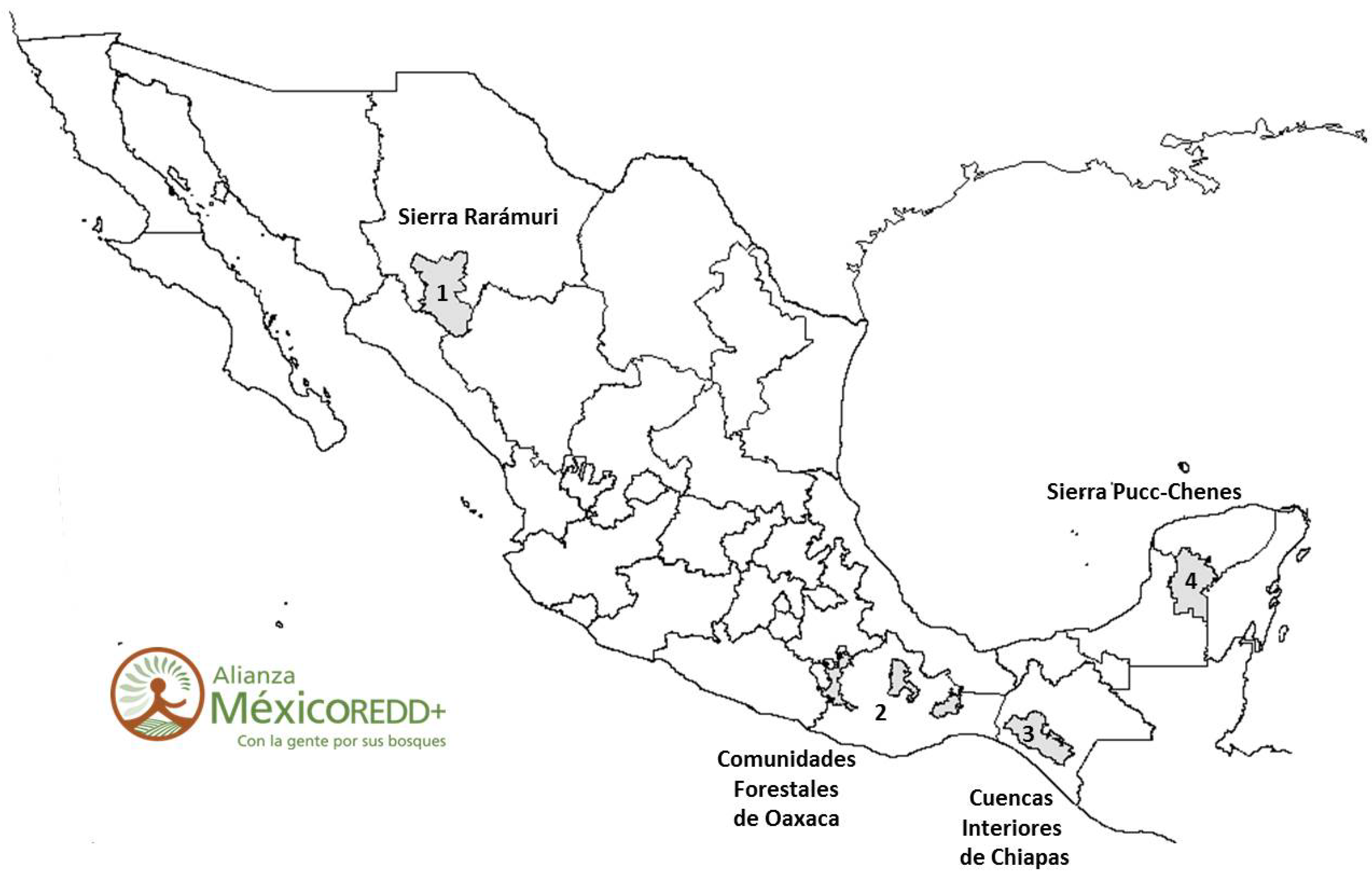
In this context, the Alliance is providing resources for the implementation of REDD+ activities in 11 projects located within the EAA of Sierra Rarámuri of Chihuahua (2 projects), the Pucc-Chenes Mountain Range in Yucatan Peninsula (3 projects), the inner watersheds of Chiapas (3 projects) and forest based communities of Oaxaca (3 projects) (Figure 1). These projects are implementing different activities to mitigate climate change including a wide variety of actors, strategies and scope. The projects were granted resources for three years based on competitive proposals submitted by different organisations that integrate local alliances for implementation.
Figure 1. Early action areas. Alianza Mexico REDD+ (image provided by TNC).
Forests 05 03295 g001
The activities proposed in the projects can affect carbon emissions or removals in forests in many different ways. Strategies include some actions that are to be developed directly in forestland (i.e., sustainable management of forest), some that take place off-forest (i.e., improved agricultural practices, reforestation), others that involve a group of regional policies (i.e., community land-use plans; environmental law enforcement), and/or a group of activities that can be oriented towards capacity building. It is recognised that action outside forested areas is necessary to address different drivers of deforestation and forest degradation (e.g., agricultural practices) (e.g., [37,38]). Additionally, the activities to be implemented by each project can vary as regards the potential to provide information compatible with national monitoring systems (i.e., activity data or information on forest areas, changes in area and management practices; and data on carbon stocks and stock changes for different reservoirs). In order to assess the potential of the projects to produce information to national systems, thus activities can be grouped into three general types that are described below.
Case A. Strategies that can produce geographical data (maps) but not data to quantify levels and changes in carbon stocks. Some REDD+ activities might have a diffuse effect on forest management, making it hard to predict the impact on carbon stocks; moreover, they may not initially include the implementation of carbon monitoring practices or targets to reduce emissions. Examples of such activities are the formulation of local land-use plans, general training on best agroforestry practices or the exclusion of cattle in forested areas. Local actors can produce activity data (i.e., area) and integrate it into a PGIS as part of project design and follow-up. Information could refer for instance to the areas of forest that have a local land-use plan, or the ejidos, communities and municipalities that have received training or the polygons where certain activities are being implemented. Such local geographical information could be integrated into the NFMS and identified accordingly as an extra stratum for analysis.
Case B. Strategies that can generate geographical data and some estimates of carbon stock changes. A second case would be the activities that in addition to geographical data could provide information on gains or losses in certain carbon stocks, though not through a comprehensive local forest inventory. Examples of these activities could be the installation of improved cook stoves (in which case, the reduction of fuel-wood extraction could be estimated based on usage) or the restoration of degraded forests by tree planting (for which calculations of biomass growth could be made). It is necessary to identify the specific data types that would need to be produced to identify suitable methods to estimate impacts of the strategies on carbon stocks, emissions or removals. In this case, the information on estimated stock changes in individual reservoirs could be included in national systems [24].
Case C. Strategies for which complete local information can be generated (Geographical & Carbon). This category corresponds to actions including the implementation of local, repeated, forest inventories, which include all the relevant carbon reservoirs. This would correspond to areas with commercial forest management plans or areas participating in carbon sequestration markets. The local forest inventory data could be combined with that of national inventories. This would however require that local inventories follow standardised protocols and the prescribed verification processes associated with the different schemes.

3. Methods

REDD+ is at an early stage in Mexico and the first projects in the EAAs are just starting. In order to assess the potential for integrating CBM into these projects, the following methodology was followed. First, the individual project proposals as submitted to TNC were reviewed to assess the potential for integrating CBM into these [39,40,41,42,43,44,45,46,47,48,49]; additionally interviews were made to project managers and a survey to evaluate the inclusion of different features related to CBM was applied to all 11 projects during the summer 2013. Appendix 1 presents basic information on each project. The potential contribution of CBM to national forest monitoring systems for REDD+ is evaluated using a multi-criteria analysis [50]. The projects are ranked according to different criteria for analysis (Table 1). At a later step, a weighted score for each project is obtained by assigning different levels of importance to each of the criteria.
Table 1. Criteria for evaluating potential contribution of projects to national systems for REDD+ and for the implementation of monitoring practices in the long-term.
CriteriaDescription
Potential contribution to national monitoring systems (50%)
Scale (25%)The contribution to REDD+ is assessed by determining the scale of direct implementation of the activities in reference to the direct influence area of the project (i.e., area where local actors have jurisdiction to implement activities) and the size of the EAA. This is made based on the description of each project [39,40,41,42,43,44,45,46,47,48,49]. Projects are ordered based on the scale of their contribution.
Expected Information (25%)The activities proposed by projects are classified as A, B or C (Section 2.4, potential to produce information on activity data and on carbon stocks and stock changes); a quantitative characterisation is made for these activities by assigning a value of 1 for activities of type A, 2 for B and 3 for C. Once all the activities proposed by the projects are evaluated, a sum of the values is made and projects are ordered from those with higher to those with lower scores.
Infrastructure and Roles for MRV (25%)The inclusion of monitoring in the projects is evaluated with regard to the formal inclusion of MRV, resources available and local capacities. If these practices have been included explicitly in the project, it receives 1 point. If the project has the required infrastructure necessary for collecting and processing the information (i.e., equipment for forest inventories, computer, internet access and GIS software), the project receives 2 points; however if the project has only part of the resources required it receives 1 point. Finally, if specific monitoring activities are defined for local actors, the project receives one more point. A total value is obtained per project and these are ordered from higher to lower scores.
Completeness of Monitoring (25%)The completeness of monitoring is evaluated in terms of the carbon reservoirs included, the specific options to produce geographical information (i.e., activity data) and the inclusion of activities to monitor leakage. Projects received a point for each factor included in their monitoring plans, and are also ordered accordingly to total score.
Temporal Sustainability of Monitoring Practices (50%)
Motivation (50%)The activities proposed by each project are classified in terms of expected linkage to public, local or private interests to identify the motivation for implementation (Section 2.2); a value of 3 is assigned to activities linked to local interests, 2 for private incentives and 1 for public programmes. For this criterion totals are also obtained and projects are ordered accordingly.
Roles in Projects (50%)Finally projects are evaluated with regard to the type of actors participating in the projects and the roles they play. Two points are granted if the project was proposed by a local actor (ejido/community); if local actors participate in the project but they are not leading it, the project is granted one point. Lastly, the project is granted a point if an NGO/academic institution with the required know-how for MRV is part of the project. Totals are obtained and projects are ordered according to the scores.
The evaluation is made in two dimensions, firstly considering the potential to provide information to national systems and secondly, analysing the potential to provide this information in the long term; each of these main criteria is worth 50% of the final mark for the projects. In order to assess the contribution to monitoring systems, projects are described in terms of (a) the geographical scales of the activities to be implemented; (b) the type of information that can be gathered as part of CBM (i.e., activity data and emission factors); (c) the resources available and roles associated with monitoring; and (d) the completeness of the monitoring practices (i.e., carbon reservoirs, geographical information and monitoring of leakage). Each of these four elements has a weight of 25%. For the evaluation of the prospects for long-term provision of information, two additional factors are assessed: first, the motivation to implement the activities described in the projects and the second, the engagement of local actors and other participants in project management. These factors contribute by 50% to the evaluation of the temporal sustainability of CBM in the projects. Here, it is assumed that monitoring activities led by local actors motivated by access to local direct benefits will be more likely to be sustainably in the long term as these represent more autonomous monitoring types [8]. For each criterion, the projects are evaluated and ranked, starting with those that are more likely to produce useful information for national systems and promote long-term collaboration. Finally, a weighted score is obtained for each project.

4. Results and Discussion

4.1. Scale of Direct Implementation

Table 2 below presents data on the projects in relation to the area of the EAA and the projects’ influence area. It can be seen that in most cases, although each project includes a number of different communities or ejidos, the projects cover only a very small part of the EAAs. Nevertheless, it is expected that as part of other deliverables of the projects, there will be a growing number of practical activities to be replicated and implemented in the mid and long terms in the areas of influence of the projects.
As regards the area for direct implementation of activities, the projects IDESMAC and UZACHI have the highest marks. IDESMAC proposes to implement best practices for coffee production over 10,000 ha. UZACHI will work towards the reduction of land use changes over an area of 3,000 ha. On the other hand the projects of Ejido Trinidad and AMBIENTARE did not specify the scale of their project in terms of area for implementation.
Looking at Table 2, it is clear that most of the activities/strategies envisaged in most of the projects take place over relatively small management units. This means that data from the national or even state level inventories will most likely not be able to measure the effect of specific practices, as their density of sampling is too low to capture the impact of changes in these (e.g., activities take place outside the plots; national inventories do not monitor relevant reservoirs; satellite images do not detect changes below the canopy). Gathering local data is therefore essential to understand how these activities impact forest area, carbon stocks and their associated changes. Monitoring the results from these pilot activities through CBM can help to identify better options for implementation of REDD+ based on specific management practices.
Table 2. Projects’ influence area and area for direct implementation in the different EAA.
EAA (ha) *ProjectProject Influence Area (Ha) (% EAA)Direct Implementation (Area; % EAA; % Project Influence Area)Rank **
Chihuahua (1,883,895 ha)Ejido Chinatu113,736 (6.0%)Fire protection 5000 ha, prescribed fire 100 ha, 20 km fire breakers, 1000 ha for conservation (water), 10 km black lines, 30 km dead organic matter soil conservation practices; 10 ha reforestation (5000 ha; 0.27%; 4.4%).3
Ejido Trinidad 88,030 (4.7%)-10
Sub-Total EAA201,766 (10.7%)
Chiapas (1’059,157 ha)BIOMASA123,200 (11.6%) (Villaflores Municipality)80 ha prescribed fires, 20 km black lines, 70 km fire breakers (80 ha; 0.01%; 0.1%).5
AMBIO30,000 (2.8%)Pilot parcels in 3 communities (pastureland and cropland management) (30 ha; 0.003%, 0.1%).6
IDESMAC119,177 (8.6%)10,000 ha with improved coffee management (10,000 ha; 0.94%; 8.4%).1
Sub-Total EAA272,377 (25.7%)
Yucatan Peninsula (1’381,924 ha)BIOASESORES105,541 (10%)12 pilot parcels (12 ha; 0.001%; 0.01%).8
PRONATURA22,984 (1.7%)Study over 250,000 ha.9
NUKUCH KA AX12,101 (0.9%)15 pilot parcels (15 ha; 0.001%; 0.1%).7
Sub-Total EAA140,626 (10.2%)
Oaxaca (1’154,839 ha)MESOFILO25,371 (2.2%)40 ha of enriched fallows, 4% households reduce 50% fuelwood consumption (Approximately 20 households) (40 ha; 0.003%; 0.2%).4
AMBIENTARE22,223 (1.9%)200 m2 nursery with capacity for 25,000 plants.10
UZACHI59,225 (5.1%)Reduction of land use change in about 3,000 ha, working with 54 community members directly (3000 ha; 0.3%; 5.1%).2
Sub-Total EAA106,820 (9.2%)
* Areas of the EAA obtained from [6]; ** The rank shows the order considering the area for direct implementation of activities as percentage of the project influence area.

4.2. Type of Activities Implemented

Table 3 presents below the list of actions proposed for each the 11 projects; it is interesting to note they differ greatly. This represents a challenge in designing a monitoring system since it should consider the particularities of the different activities while maintaining the compatibility of the results. Activities are described in terms of the location where they take place (forest/off-forest) and whether they refer to interventions to enhance local governance and capacities or specific factors related to monitoring systems and REDD+. Actions proposed by the projects are described in terms of the expected geographic information and on carbon stocks that can be gathered (as A, B or C, as described above in Section 2.4), and also in terms of the typical type of motivation for implementation (i.e., Public, Local or Private, as described in Section 2.2). Activities associated with private motivation include those oriented to carbon markets and other certification schemes, and in the broader sense cash/market-oriented activities and research oriented projects. Using these criteria each project is evaluated by taking into account the different activities proposed. Hence, there are two ranks presented in Table 3, first that related to the information that can be gathered and included in national monitoring systems; and secondly, a rank for the type of motivation for the implementation. The projects with the highest marks in terms of information to be gathered are UZACHI followed by Ejido Trinidad and MESOFILO. UZACHI included various activities that can produce information on activity data and information on the different carbon reservoirs through forest inventories, projects oriented to carbon markets, development of local allometric equations and carbon accounting.
The second criterion concerns the motivation associated with the implementation of each activity. Columns 7–9 present the classification of each activity based on whether these are associated with public programmes, local interests or private incentives. When one activity can be linked to more than one option, the highest value is recorded. The strategies presented in Table 3 could be analysed in detail to define whether they have been included in the projects as a response to external incentives or to local interests. However, this analysis would require a deeper documentation of the projects including interviews to members of the communities involved in each project, which is beyond the scope of this work. In terms of the type of motivation for implementation, the projects with the highest marks are UZACHI, Ejido Trinidad and AMBIO. These are the projects in which more of the activities proposed may generate local benefits and respond to the interests of the community.
If local information is used only for local internal interests, it could happen that protocols for measurement, evaluation and storage of data would not be as stringent as those for externally driven projects; and it may not fulfil the requirements for external use in national systems. Hence, in order to integrate the information to be produced by the projects with national systems, the first task would be to harmonise the protocols for data gathering, processing and reporting so that all the projects use a common approach. In some cases it would be necessary to design and create ad hoc monitoring schemes for the relevant carbon reservoirs (e.g., when the activity does not have carbon monitoring as an initial objective). However, for cases B and C, once the data is produced and processed it should be possible to determine the resulting reduction of emissions or carbon removals in terms of tCO2e/ha-yr.
Table 3. Definition and classification of the actions proposed as described in the projects of the Alliance.
ActionsLocation of Activity or Type of ActivityExpected Information to be GatheredType of Activity (Case) *Type of Motivation *Projects Mentioning the Activity/Intervention
1. Activity Data2. Some Carbon Reservoirs3. All Carbon Reservoirs1. Public2. Local3. Private1. Ejido Chinatu2. Ejido Trinidad3. BIOMASA4. AMBIO5. IDESMAC6. BIOASESORES7. PRO-NATURA8. NUKUCH KA AX9. MESOFILO10. AMBIEN-TARE11. UZACHI
Improved Forest ManagementForestXXXCXX XX XX XXXX
Forest Management Certification SchemesForestXXXC XX X X
Forest ConservationForestXX BXXX X
Restoration Critical AreasOff-forestXX BXXX
Fire Management PracticesForestXX BXX XXX XX XX
Soil Conservation PracticesOff-forestXX ** BXX X X XX
Improved CoffeeOff-forestXX ** B XX X X X
Beekeeping (reforestation/restoration for…)Off-forestXX B XX X X
Camedor Palm ProductionOff-forestXX ** B XX X X
EcotourismOff-forestX A XX X
PESForestXX BX X
Reforestation/AfforestationOff-forestXX BXXXX X X
Improved Grazing/ RanchingOff-forestXX B XXX XX XXXX
Improved FallowOff-forestXX B XX X X
AgroforestryOff-forestXX B XX X X
Organic AgricultureOff-forestXX B XX X X
Improved Corn ProductionOff-forestX A X X X X XX
Biological Pest ControlOff-forestX A X X X
Protein BanksOff-forestX A XX X
Productive Activities Low Carbon DevelopmentOff-forestXX B X XX XX
Food Production at homeOff-forestX A X X
Eco TechniquesOff-forestXX BXXX X
Tree NurseriesOff-forestX AXXX X X X
Carbon MarketsOff-forestXXXB/C X X
Land use PlansGovernance/ CapacitiesX AXX XXXX X XXX
Governance, Coord. Plann.Governance/ CapacitiesX AXX XXXX XX X
Financing Benef. Shar.Governance/ CapacitiesX AX X X
Market AccessGovernance/ CapacitiesX A X XX X X
Best PracticesGovernance/ CapacitiesXX ** B X XX X
Pilot ActivitiesGovernance/ CapacitiesXX ** B X X XXX
Training, Cap. BuildingGovernance/ CapacitiesXX ** BXXXXXXXXXXXXXX
Evaluation ProtocolsMonitoringXX BXX XXX XX X
Wildlife Inv.MonitoringX AXXX X X X
Forest InventoryMonitoringXXXB/CXXXXXX XX
Carbon AccountingMonitoringX AX X XXX XXX
Monitoring Water and Env. Serv.MonitoringX AXXX X X
Development of Allometric EquationsMonitoringXX BXXX X
Online Repository of InformationMonitoring NAXXX X
Community MappingMonitoringX AXXX X
GPS useMonitoringX AXXX X
Identification of DriversREDD+X AXXX
Total of Actions to be Implemented913131312111010141116
Rank Considering Expected Information to be Gathered72454687361
Rank Considering the Type of Motivation of Activities to be Implemented71315456251
* For evaluation, regarding the expected information, projects receive 1 point in case A, 2 for B and 3 for C; regarding the type of motivation projects receive 1 for Public Programmes, 2 for Private Incentives and 3 for Local Interests. For the activities with more than one possible values the highest one is used; ** It is not clear how/if carbon accounting will be incorporated into these practices; *** Reforestation/Afforestation practices take place in non-forest land, however if the projects are successful after 20 years areas can be reclassified as forests; NA. Not Applicable.

4.3. Infrastructure and Capacities for MRV

In order to gain a more detailed view of the monitoring practices in the project, a questionnaire was sent to project leaders which included questions about inclusion or the creation of a MRV system, the different roles expected from the different actors and capacities and infrastructure available. Table 4 presents a summary of the responses obtained to these questions.
Table 4. Roles and infrastructure for the monitoring, report and verification (MRV) of activities of the projects financed by the Alliance.
Project *MRV Formally IncludedResponsible for Analysis and ReportingInfrastructureRole/Capacities of CommunitiesRole/Capacities External ExpertsRank **
Ejido ChinatuNoProject information to be reported by external consultantsConsultants provide equipment including GIS software.Capacities for MRV are neededForest management, Capacities for MRV (technicians)3
Ejido TrinidadNoForest technicians elaborate reports according to forest management plansComputer, internet, brigades and GIS software available.N.S.Forest management3
BIOMASANoConsultantsField equipment to estimate fuels, computer and GIS softwareN.S.N.S.3
AMBIONoN.S.Brigade, computers and GIS softwareData gatheringAnalysis2
IDESMAC-----5
BIOASESORESYesConsultants-Capacities for MRV are neededMeasurement and monitoring, some capacities are required4
PRONATURAYes (M only)ConsultantsBrigade, computers and GIS softwareCapacities required for data gatheringCapacities for MRV are needed2
NUKUCH KA AXYesExperts and communitiesBrigade, computers and GIS softwareCapacities for MRV are neededCapacities for MRV are needed2
MESOFILOYes (MR only)Experts and academiaComputer and brigade equipment, not mentioned GIS softwareCapacities for MRV are neededSIG and Project management, capacities for MRV needed3
AMBIENTAREYesN.S.Brigade, computers and GIS softwareNeed to build capacities for monitoring, PGIS and inventories.SIG, inventories, and reporting.2
UZACHIYesAnalysis Academia, Report, UZACHIBrigade, computers and GIS softwareThere is a high degree of social organizationInformation management and methodology1
N.S. Not specified; * IDESMAC project did not complete the questionnaire; ** Projects received one point for the formal inclusion of MRV; one point if the project has access to the required equipment and infrastructure and another point if local actors/communities have defined roles.
In Table 4, it can be seen that not all the projects have included practices for MRV in their design and in some cases there is reference only to the monitoring or reporting of information. In general, all the projects have access to computers, internet connection, basic equipment for forestry inventories and GIS software. However, most of these resources are not part of the assets of the communities but of consultants, NGOs and academia, who are charged with processing the data. This corresponds to Danielsen et al. [8] Type II (or possibly Type III, where communities act mostly as gatherers of local data) as regards community involvement. NUKUCH KA AX and UZACHI are exceptions since local participants will participate in analysis and reporting. Capacities for the local analysis of information have not been developed consistently and homogenously across communities participating in the projects. The prominent role envisioned for communities as part of CBM will be that of data gathering and only AMBIO and UZACHI acknowledged that the required capacities for this are in place; these two projects obtained the highest marks in the evaluation on this criterion although AMBIO did not include specific MRV activities as part of their project proposal since this would require additional resources.

4.4. Completeness of Monitoring

Project leaders were specifically asked if CBM had been considered as part of the monitoring activities in the assessment of specific variables related to carbon reservoirs and geographical information. Table 5 presents the responses obtained.
Although in some cases projects did not include specific provisions for setting up an MRV system, the activities to be implemented will generate information that could possibly be integrated into such a system. However, as noted above, it will be necessary to standardize monitoring practices since there are large variations across EAA and even among projects in the same regions. The projects that obtained the highest ranks were BIOASESORES and UZACHI. Conversely, the projects with the lower marks are AMBIO, MESOFILO and NUKUCH KA AX. The case of AMBIO indicates that although the members of the project may have the required skills and resources to perform monitoring practices, resources for this are needed and the scope and resources granted were not enough to include monitoring of the activities proposed. Most of the projects have included practices to monitor biomass and carbon stocks in trees (the principal carbon reservoirs); it will be easy to standardize monitoring practices for monitoring trees and this can set a common point of departure. It will take more time to develop and deploy comparable methods to monitor other carbon pools such as dead organic matter (fuelwood is a resource of local interest in rural areas), as to develop a system for the representation of lands and different forms of leakage.
Table 5. Information to be generated by the projects. Is CBM considered for the generation of the following information? *.
VariableEjido ChinatuEjido TrinidadBIOMASAAMBIOBIOASESORESPRONATURANUKUCH KA AXMESOFILOAMBIENTAREUZACHITotal
Carbon Reservoirs (Stocks and Changes)
Biomass (Above and below ground, trees, shrubs and herbs)YesYes **YesNo **YesYes **NSYes **YesYes10
Soil (Organic, Mineral)NoYes **NoNo **YesNoNoNoNoYes5
Dead Organic Matter and LitterYesYes **YesNo **YesNoNoYes **NoYes8
Emissions from disturbances (fire, pests, meteorological)NoNoNoNoYesYes **NoNoNoYes5
Storage in Harvested Wood Products (Timber, other)NONoYesNoYesYes **NoNoNoNo3
Illegal Logging (reports)NoNoNoNoYesYes **NoNoNoNo4
Information on Representation of Lands
Representation of Lands (Stratification, vegetation type, areas with different management practices)YesYesYesNo **YesYes **NoNoYes **Yes7
Mapping the area of each stratumYesYesNoNo **YesYesNoNoYes **Yes6
Monitoring land use change of forest areas.YesYesNoNo **YesYes **NoNoYes **Yes8
Monitoring changes in canopy cover.YesYes **NoNoNoNoNoNoNoYes3
Leakage
Displacement of extractive activities (timber, fuel-wood, soil).YesYesYesNoYesYes **YesNo **Yes **Yes8
Displacement of grazing activities.YesYesYesNoYesYes **YesNoYes **Yes8
Displacement of agricultural practices.YesYesYesNoYesYes **YesNoYes **Yes8
Rank4358136752
The answers shown as ‘Yes’ receive 1 point for the evaluation; * IDESMAC did not complete the questionnaire; ** Project leaders provide a brief description of the methods.

4.5. Roles and Actors

One of the objectives of creating local capacities for CBM is to produce systems that could be sustained over time, preferably without the need for external incentives. In this context, the prospects for creating sustainable CBM schemes are defined as the potential to maintain REDD+ activities and their monitoring once the support from the Alliance ends. All other things being equal, it may be expected that with more community involvement (higher on Danielsen’s scale [8]), sustainability will be more likely. Table 6 presents the type of stakeholders participating in the projects, identifying the type of project proponent (leader).
Table 6. Members of local alliances and involvement of local communities.
ProjectProject Proponent (Type)Other Members of Local AllianceRank
Local ActorsNGO/Consult.Acad.Gov.
Ejido ChinatuLocal Actors * 2
Ejido TrinidadLocal Actors XX 1
BIOMASANGOXXX 2
AMBIONGOXXX 2
IDESMACNGOXXX 2
BIOASESORESNGOXXX 2
PRONATURANGOXX 2
NUKUCH KA AXLocal ActorsXX 2
MESOFILONGOX 2
AMBIENTARENGO* X3
UZACHILocal Actors X 1
Projects received 2 points if the projects were proposed by a local actor/community, 1 point if local actors are included as part of the projects, and 1 more point if the project includes a technical member (i.e., NGO/Consultant or an academic institution); Consult.: Consultants; Acad.: Academia; Gov.: Government; * Actors are not specified formally as members of the local alliance for the implementation of the project.
Table 6 shows there are different actors participating in these projects: local actors (ejidos or producers’ unions), NGOs or consultants, academia and public offices. The projects were proposed officially by an individual actor to the Alliance, and each proposal mentions who the other official members of the project are (local alliance). Four projects were proposed directly by local actors (communities or productive unions); these are the ejidos Chinatu and Trinidad in Chihuahua and the unions of NUKUCH KA AX in the Yucatan Peninsula and UZACHI in Oaxaca. In these projects, local actors have developed interest, capacities and initiative to engage into REDD+ related activities and thus might have a good chance of continuing efforts in the mid and long terms. The projects with the highest ranks are UZACHI and Ejido Trinidad.
The remaining seven projects were proposed by NGOs, many of which had long standing experience in collaborating with local actors in local management of natural resources (e.g., AMBIO, PRONATURA). In terms of specific abilities and capacities for data management and processing, all the projects with the exception of Ejido Chinatu include either NGO/consultants and/or academic institutions. In these projects, some critical tasks will be done by the experts external to communities (e.g., proposal writing, project planning, data management and GIS analysis), but it would be important to identify how communities could start to adopt and lead these activities. If NGOs have predictable and sufficient sources of funding to cover their overheads this might help to run the projects and create local capacities for the implementation of REDD+ activities in the longer term. This offers a period of opportunity to initiate processes to build local capacities and mechanisms for the adoption of locally driven sustainable management practices and local governance schemes, including monitoring. Ejido Chinatu mentioned that external consultants will participate in the analysis of information. They will be hired by the ejido, but are not a formal party in the project.
The participation of academia can also provide long term access to specialized know-how and trained personnel as long as researchers and students have funding and time. In this case, it will be necessary to prevent potential conflicts related to data ownership, management and publication. Sometimes, part of the technical information collected and analysed by researchers is withheld until it has been published in academic journals. These actors should have the capacities and infrastructure to process and store the information, however if the objective is to transfer these capacities and facilities to local communities some specific activities need to be implemented.
There is however one project in which local actors are not officially members of the partnership according to project documentation, this is AMBIENTARE. This project obtained the lower marks in the evaluation of this criterion. The project was proposed by an NGO in collaboration with environmental governmental offices (CONANP/SEMARNAT); the document mentions that the project will be implemented in three communities and two ejidos from three different municipalities however they are not mentioned as being project members.

4.6. Summary of Results

Table 7 presents the overall evaluation of the projects financed by the Alliance taking into account the potential contribution to national monitoring systems and the prospects for long term sustainability of monitoring schemes based on the multi-criteria analysis.
The evaluation produced separated rankings for the contribution to monitoring systems and for the evaluation of the prospects for temporal sustainability. In both cases, the project led by UZACHI had the highest marks. This project will implement activities that may produce information compatible with national systems and that may also motivate long-term implementation and monitoring. The project is led by a local organisation with the skills and infrastructure needed to undertake monitoring and analysis of information. In terms of potential contribution to monitoring systems the projects PRONATURA, NUKUCH KA AX and AMBIENTARE had the lowest marks. These projects propose actions over relatively small areas, such that their activities will not generate complete information that can be integrated into national systems; moreover, their proposed monitoring practices include few parameters. Regarding the prospects for sustained monitoring over time, in addition to these three projects, IDESMAC also had a lower score. The case of AMBIENTARE imposes great challenges for the continued practice of monitoring since local actors were not mentioned as members of the project.
Table 7. Overall evaluation of potential contribution to MRV systems and temporal sustainability of monitoring schemes of the projects financed by the Alliance Mexico REDD+.
ProjectPotential Contribution to National Monitoring Systems (50%)Temporal Sustainability of Monitoring Practices (50%)Final Score (Rank)Classification (Danielsen et al. [8])
Scale (25%)Expected Information (25%)Infrastructure and Roles for MRV (25%)Completeness of Monitoring (25%)Total Score (Rank)Motivation (50%)Roles in Projects (50%)Total Score (Rank)
Ejido Chinatu37344.25 (2)724.50 (8)4.38 (6)III
Ejido Trinidad102334.50 (3)111.00 (1)2.75 (2)III
BIOMASA54354.25 (2)322.50 (4)3.38 (4)II
AMBIO65285.25 (5)121.50 (2)3.38 (4)II
IDESMAC14594.75 (4)523.50 (6)4.13 (5)II
BIOASESORES86414.75 (4)423.00 (5)3.88 (4)II
PRONATURA98235.50 (6)523.50 (6)4.50 (7)II
NUKUCH KA AX77265.50 (6)613.50 (6)4.50 (7)III–IV
MESOFILO43374.25 (2)222.00 (3)3.13 (3)II
AMBIENTARE106255.75 (7)534.00 (7)4.88 (8)I
UZACHI21121.50 (1)111.00 (1)1.25 (1)III–IV
Table 7 enables the identification of particular strengths for each project as well as a general overview. The last column in Table 7 describes the type of monitoring scheme for each project based on the classification proposed by Danielsen et al. [8] and on the evaluation made in this work. One project (AMBIETNARE) corresponds to type I of monitoring schemes, this is an externally driven intervention that is most likely to stop once the external support ends. The majority of the projects correspond to type II, these are the projects led by external NGOs but include the participation of local actors. In these cases while communities may have participated in the design of the project and identification of the management activities to be implemented, the main role they will play in the monitoring will be data gathering. There are technical parties in the projects (NGOs and Academia) with the resources and skills that will lead the analysis and interpretation of information that can be used for external reports in a first instance for the Alliance. Finally, there are four projects classified as type III or IV in the typology of Danielsen et al. [8]. These are collaborative projects with a higher degree of participation and leadership of the local actors. In projects of type III, external partners assist the communities in the analysis and interpretation of information (Ejido Chinatu and Ejido Trinidad). Only the projects UZACHI and NUKCH KA AX identified members of the communities as actors responsible for analysis and reporting of information; these projects fall between type III and IV because there are also other external actors collaborating in these tasks.

4.7. Further Steps: Project eREDD+

The review of the 11 projects financed by the Alliance shows that in general, the resources to implement local monitoring activities through CBM activities are in place. In most cases, these capacities reside in specialised organisations such as NGOs and academia. However, the review of these projects showed that at least two projects have also developed the required skills and could transit towards more autonomous schemes. Nevertheless, although the infrastructure and capacities are in place it is necessary to dedicate appropriate resources for the implementation of monitoring systems based on CBM, as the case of the project led by AMBIO illustrates. Moreover, it is necessary to define the activities that could be included in REDD+ (e.g., in forest and off forest areas) along with the technical requirements for the participation of communities in national systems (e.g., methods, formats, procedures).
Considering the need for a common base for CBM and stemming from the early experiences of the Alliance Mexico REDD+, there is a new project being developed called “Strengthening of local capacities for CBM in Mexico”. The goal of this project is to research, develop and test methods to integrate data from ground-based CBM with remote sensing, GIS and web-enabled reporting tools, in the context of a nested monitoring system. During a first stage of the project, a web-based platform will be designed and created to capture, transmit, store, systematize, analyse and present results based on CBM for a wide range of data users (i.e., eREDD+ System). The system will standardize monitoring practices across the projects financed by the Alliance, including the basic requirements for the integration of information to national systems and it is expected that it will reduce the barriers and costs of CBM. At a later stage such information will be made available from the different studies and strategies implemented by the Mexico REDD+ Alliance and strategic partners. For these, the pilot initiative will develop tools and methodologies, while providing training to a group of ejidos/communities on a CBM protocol. This project is an initiative from the Mexico REDD+ Alliance, Mexico-Norway Project, FAO and LAIF working together with local communities, academic institutions and civil society organisations.

5. Conclusions

There are two requisites that need to be reconciled in national monitoring systems for REDD+ including CBM: on the one hand the process should ideally include active participation of local actors from a bottom-up approach, not least because this may enhance the prospects for sustainable monitoring schemes. On the other hand national systems need to establish a set of protocols and a minimum of standards to ensure that the information generated at the local level can be integrated into the larger MRV system and NFMS. The challenge at project level is to create a unified monitoring scheme, which is compatible with national systems and also provides useful information for local management. Such a scheme should engage communities already prepared to manage their natural resources more actively into monitoring, analysis, interpretation and use of information.
For effective monitoring in REDD+ it is clear that collaboration will be needed between communities and projects at the local level. In the case of Mexico, the draft ENAREDD+ states clearly that local implementation will start at the ejido and municipality levels. This work made a review of 11 projects being implemented in Mexico to explore the potential to include CBM and to produce information compatible with national monitoring systems for REDD+. The results indicate that the capacities and resources to produce local information for national monitoring systems are in place at the project level. In most cases, these resources reside in NGOs and academia, but also in communities, which have a higher degree of organisation. However, in many projects the prominent role of local communities in CBM will be data gathering. Hence, in most of the cases, at least initially, the processes for integrating local information into monitoring systems would be externally driven. In the fewer cases when more autonomous locally driven schemes could be implemented, information will be produced and used according to local interests; these cases may maintain monitoring activities in the long term [8].
There are two important challenges in integrating local information into the national monitoring systems of REDD+. First, since projects will implement many different activities (see Table 3), the information will not be entirely compatible with national systems (i.e., parameters, formats, protocols); and secondly, since the information is owned by communities, an agreement will be needed to share and include sensitive information into the reporting systems of REDD+ [24]. A comprehensive strategy to include CBM into national systems for REDD+ will need to consider these issues. If a country aims to produce monitoring schemes driven by local actors, an initial investment is required to provide the necessary resources (i.e., computers, software, satellite imagery, internet connection) and to create local capacities including technical and organisational skills. The organisational skills refer not only to the planning and management of CBM plans, but in a broader sense to the management of natural resources of local interest. Moreover, it is necessary to identify the activities that produce more benefits at the local level while contributing to the objectives of REDD+ since these will increase the chances of designing enduring interventions. Projects under development in EAAs can contribute to evaluate the contribution of different management practices to the reduction of emissions and promotion of carbon enhancements. Thus, carbon emissions/removal factors obtained through projects could be integrated into the design of further REDD+ activities. It will be necessary to define and create the platforms to integrate local information into the national monitoring systems for REDD+.

Acknowledgments

This document is based on the reports Balderas Torres [51,52]. In reference to this work the author would like to acknowledge the contribution of Margaret Skutsch, Alejandra Larrazabal and Hugo de Alba and to Tuyeni Mwampamba and Miguel Angel Salinas Melgoza of CIGA-UNAM, Fernando Paz from COLPOS, and Peter Ellis of TNC for their comments. Likewise, the documents have also benefited greatly from the interviews made to, and comments received from, Ignacio March, Yves C. Paiz, Sébastien Proust, Ian Starr and the project coordinators who were interviewed and answered the questionnaires: Eric Castañares, Lizeth Hernández, Guillermo Velasco, José Hernández, Claudio Vicente Franco, Angélica Padilla Hernández, Pilar E. Pérez Delgado, Sotero Quechulpa Montalvo, Marcela Delgadillo Ramírez, Angélica Padilla Hernández, Gerardo García Contreras, Maria Antonieta Bocanegra, Ejidos Chinatu, La Trinidad, Catedral and Nopal, Grupo Mesófilo A.C., Asociación Regional de Agrosilvicultores del sur de Yucatan Nukuch Ka Ax A.C, Biodiversidad, Medio Ambiente, Suelo y Agua, AC, Unión de Comunidades Productoras Forestales Zapotecos-Chinantecos de la Sierra Juárez de R. I. (UZACHI), and BIOASESORES A.C. and to Jaime Severino, Noé Castellanos, Ana Karla Perea, Alejandra Aguilar, Sergio Armando Villela Gaytan and César Moreno García of CONAFOR; José Ma. Michel Fuentes of the Mexico-Norway Project; and to Noah James Chutz and Sofia Magdalena García Sánchez of the LAIF project to whom the author is indebted. About Balderas Torres [51,52]: “This publication was possible through the generous support of the people of the United States through the United States Agency for International Development (USAID) under the terms of Cooperative Agreement No. AID-523-A-11-00001 (Project for Reducing Emissions from Deforestation and Forest Degradation in Mexico) implemented by the prime contractor The Nature Conservancy and its partners (Rainforest Alliance, Woods Hole Research Center and Natural and Espacios Naturales para el Desarrollo Sustentable). The contents and opinions expressed herein are those of the authors and do not reflect the views of Project for Reducing Emissions from Deforestation and Forest Degradation of Mexico and the Agency United States Agency for International Development, the Government of the United States of America”.

Appendix

The description of the projects presented below is based on the documents of the projects, interviews to project coordinators and responses to the questionnaires.

EAA Chihuahua

Ejido Chinatu [39]

The objective of the project proposed by the ejido Chinatu is to restore the Turuachi river basin located in the state of Chihuahua; for this, the project will implement natural resource preservation practices, including sustainable forest management and the implementation of community planning instruments. The section of the basin to be restored is located in the ejido Chinatu, in the municipality of Guadalupe y Calvo that hosts nine indigenous communities; the project is developed in the Tarahumara region. The ejido has an area of 113,736 ha (12% of the municipality’s area), from which 95,137 ha are forest (15% of the total municipality’s forest land); out of this land, 42,609 ha are the exploitable woods pine and oak. The project will be developed in an area with forest-land use vocation of 86,090 ha specifically in the 5000 ha of the Turuachi river basin where there are 9 communities all part of the ejido Chinatu.

Ejido Trinidad [40]

The project’s main objective is to achieve the sustainable and integral development of three ejidos from the Guadalupe y Calvo municipality in Chihuahua. It aims to contribute to a development model that should be economically competitive, socially and culturally equitable, ecologically sustainable and regionally balanced. The municipality has a total population of 53,499 and an area of 9629.05 km2 from which 65.2% is covered by forestland (pine-oak forests). Other main land uses are agriculture and grasslands for grazing, the main crops harvested in the municipality are maize, oatmeal and bean. The ejidos that will be involved in the project are La Trinidad (48,013 ha), El Nopal (4417 ha), and Catedral (35,600 ha) involving 11 communities overall. Land is communally owned and is used mainly in forestry. The project is proposed by Ejido La Trinidad in collaboration with other actors (i.e., a consultancy firm, a civil association and a local university). The ejidos have forest management plans for timber extraction; La Trinidad has been certified under the FSC. The ejidos have experience with reforestation practices, PES programs (i.e., hydrological services, 5076.06 ha in La Trinidad, 462.01 ha in El Nopal), soil conservation and restoration practices and wildlife management.

EAA Chiapas

BIOMASA [41]

The project was proposed by Biodiversidad, Medio Ambiente, Suelo y Agua, A.C. Its main objective is to boost pilot models of productive and environmental alternatives in four microbasins in the Villaflores municipality, located in the Sierra Madre de Chiapas. This will be achieved by implementing sustainable forest management strategies and environmental safeguards, and by strengthening local abilities to contribute to the communities’ REDD+ preparation. The project will be located in the limit and buffer zones of the “La Sepultura” biosphere reserve and the natural resources protection area “La Frailescana”. Villaflores has a 1232.2 km2 area, from which 50,000 ha are pine, oak, and evergreen forests. The four microbasins of the El Tablón river, where the project will take place, are Champerico, Nuevo Horizonte, Villahermosa, and Nueva Palestina. These hold 11 ejidos, a 20,000 ha surface (from which 15,000 are commonly owned), and 2950 inhabitants.

AMBIO [42]

The project presented by Cooperativa AMBIO S.C. de R.L. aims to create a low emission rural development strategy in the area by leading productive activities toward sustainable practices and participative planning processes in order to improve the legal framework to favor social participation. Located at the Sierra Madre de Chiapas, the Natural Resources Protection Area (APRN) La Frailescana is an important biological corridor that provides several environmental services. It is located in four municipalities of Chiapas (La Concordia, Ángel Albino Corso, Jiquipilas, and Villaflores); 25.5% of these municipalities’ area is forestland, 26.4% is agricultural areas and 14.9% is grassland. The most important agricultural products are bean, maize, and sorghum. Existing vegetation in APRN La Frailescana includes low and high evergreen forest, low and high deciduous forest and oak and pine forests, however they are decreasing in area. The most abundant covers are secondary vegetation, grasslands and seasonal agricultural lands. The project will benefit 16 communities, accounting for more than a thousand families distributed in more than 30,000 ha.

IDESMAC [43]

The project’s objective is to implement a strategy for territorial development at different levels to reduce emissions from degradation and deforestation in eight agricultural sites from Reserva de la Biósfera El Triunfo (REBITRI). The project was proposed by Instituto para el Desarrollo Sustentable en Mesoamérica, A.C. REBITRI has a 119,177 ha area with ten different types of vegetation: deciduous and evergreen forests, oak-pine forest and cloud forest. The reserve holds endemic and endangered species. It works as a rainwater catchment area to feed Mexico’s most important hydroelectric system and nine rivers that work as a water source for different towns and irrigation systems. The agricultural sites are located in four municipalities from the state of Chiapas: Ángel Albino Corzo (Santa Rita and Querétaro), La Concordia (Plan de la Libertad and La Concordia), Montecristo de Guerrero (Toluca and Montecristo de Guerrero), and Siltepec (Ángel Díaz and Honduras) these cover 48,653 ha and hosts 3018 people (total population of the four municipalities is 115,753). Main productive activities are agriculture, palm gathering, commerce, crafting and livestock.

EAA Yucatan Peninsula

BIOASESORES [44]

The objective is to design, plan, and develop a concept and pilot model of MREDD+ development in four pieces of land in the Puuc-Chenes region in the municipalities of Tekax and Oxkutzcab in Yucatán and Hopelchen in Campeche through low carbon emission activities, capacity building and communication development, and the implementation of safeguards and MRV system. The ejidos participating are: San Agustin (Tekax), Yaaxachen (Oxkutzcab), Bolonchen and Yaxche (Hopelchen). The total influence area is 105,541 ha. The existent ecosystem is medium deciduous forest, however the conditions of resources vary from one community to another. The main crops grown in these municipalities are maize and pastures; however, the land is mainly forest (85% of the area).

PRONATURA [45]

The project was proposed by Pronatura Península de Yucatán, A.C. Its objective is to strengthen the technical and organizational capacities of the Puuc-Chenes corridor through the development of local and regional land management and governance mechanisms that will link rural development and sustainable management programs in Hopelchén. The project will be located in the Puuc-Chenes region in Hopelchén, Campeche, which total area is 89% forest. Existing vegetation are forests, herbaceous and shrub secondary vegetation, grasslands, and seasonal agriculture. The region’s importance resides in the fact that it is a corridor between two ecological reserves. Three ejidos were chosen for this project: Chun ek (15,700 ha, 124 inhabitants, 23 communal land owners), Ramón Corona (3854 ha and 39 communal land owners), and Francisco J. Mújica (3700 ha and 37 communal land owners). This covers 33% of Hopelchén’s area. Hopelchén’s population is mainly indigenous (76%). It is estimated that the project will benefit 90 people directly and 200 indirectly.

NUKUCH KA AX [46]

The project aims to develop and implement pilot parcels in five ejidos of the Forest Management Unit (UMAFOR) 3106 by developing capacities and transforming productive activities through intensive pastureland management systems, improved maize production, and organic agriculture. It was proposed by Asociación Regional de Agrosilvicultores del Sur de Yucatán Nukuch Ka Ax A.C. The chosen ejidos and the municipality in which they are located are described as follows: Tekax has 87% to forest and 10% to agriculture; San Juan Tekax and Becanchen (10,069 ha and 298 communal land owners, 36% of surface is covered by secondary vegetation, 18.2% by dry forest, and 45.5% by agricultural land); Tzucacab, 74% of the territory is occupied by forest and 21% by agriculture; San Isidro (2031.5 ha and 25 communal land owners) and Ekbalam. From Oxkutzcab, which land is occupied 78% by forest-land and 21% by agriculture; Xul will be partly reforested to diversify activities.

EAA Oaxaca

MESOFILO [47]

The project proposed by Grupo Mesófilo A.C. aims to implement in a participative way actions that may fortify the conservation of natural resources and incentives to assure the continuity of ecosystems in the Rincón de Ixtlán zone, Sierra Norte de Oaxaca, as a contribution to carbon emission reduction. The project covers an area of 25,371 ha (35% of the municipality’s area) of communally owned land and is located in Sierra Norte. Involved localities are: San Miguel Tiltepec (9769.82 ha), San Juan Yagila (1576.61 ha), Santa Cruz Yagavila (1469.03 ha), Santa María Zoogochí (687.21 ha). The project intends to benefit 250 people directly and 1800 people indirectly (27% of the municipality’s total population). Marginalization in the area is high.

AMBIENTARE [48]

The main objective of the project is to develop land and forest resource management instruments and to strengthen capacities related to different REDD+ components to avoid degradation and lead to better management practices in three communities and two ejidos in Santa Catarina Zapoquila, San Juan Suchitepec, and San Francisco Teopan in Oaxaca. The zone holds a population of 1259 people, distributed in 16 rural communities living with high poverty and marginalization conditions. The project will benefit 75 people directly and 831 people indirectly. The ecosystems found in the area are coniferous and hardwood forests. Around 22,223 ha (75% of the municipalities’ total area) have no management plan and 4845 ha are productive and settlement areas. From the total area, 59% is secondary vegetation, 22% is grassland and 19% is forest-land. The project was proposed by AMBIENTARE, A.C.

UZACHI [49]

The Project was proposed by the UZACHI (union of local producers). Its main objective is to develop a participative community monitoring scheme that allows the measurement of the carbon reserves increment based on data from de National Forest Inventory and measurement units, as well as measurement of emission levels linked to better practices on natural resources management and considering monitoring of water and biodiversity environmental co-benefits. The project will reside in the following communities: La Trinidad, Capulálpam de Méndez, Santiago Xiacuí, Santa María Jaltianguis, San Juan Evangelista Analco (all of these located in the Sierra Norte), San Juan Ozolotepec, and Santa María Lachixonace (located in the Sierra Sur), covering an area of 57,464 ha.

Conflicts of Interest

The authors declare no conflict of interest.

References and Notes

  1. Report of the Conference of the Parties on its thirteenth session. Addendum. Part Two: Action taken by the Conference of the Parties at its thirteenth session. In Proceedings of the Bali Climate Change Conference, Bali, Indonesia, 3–15 December 2007; United Nations Framework Convention on Climate Change (UNFCCC): Geneva, Switzerland, 2008.
  2. Report of the Conference of the Parties on its fifteenth session. Addendum. Part Two: Action taken by the Conference of the Parties at its fifteenth session. In Proceedings of the Copenhagen Climate Change Conference, Copenhagen, Denmark, 7–19 December 2009; United Nations Framework Convention on Climate Change (UNFCCC): Geneva, Switzerland, 2010.
  3. Report of the Conference of the Parties on its seventeenth session. Addendum. Part two: Action taken by the Conference of the Parties at its seventeenth session. In Proceedings of the Durban Climate Change Conference, Durban, South Africa, 28 November–11 December 2011; United Nations Framework Convention on Climate Change (UNFCCC): Geneva, Switzerland, 2012.
  4. Report of the Conference of the Parties on its sixteenth session. Addendum. Part two: Action taken by the Conference of the Parties at its sixteenth session. In Proceedings of the Cancun Climate Change Conference, Cancun, Mexico, 29 November–10 December 2010; United Nations Framework Convention on Climate Change (UNFCCC): Geneva, Switzerland, 2011.
  5. Alliance Mexico REDD+. Convocatoria a proyectos de campo a través de alianzas para la preparación a REDD+; Alianza México MREDD+ and Comisión Nacional Forestal: Mexico City, Mexico, 2012. [Google Scholar]
  6. Alliance Mexico REDD+. ¿Qué es MREDD+? Alianza México REDD+. Available online: http://www.alianza-mredd.org/acerca-de-mredd/ (accessed on 23 July 2013).
  7. Danielsen, F.; Burgess, N.D.; Balmford, A. Monitoring matters: Examining the potential of locally-based approaches. Biodivers. Conserv. 2005, 14, 2507–2542. [Google Scholar]
  8. Danielsen, F.; Burgess, N.D.; Balmford, A.; Donald, P.F.; Funder, M.; Jones, J.P.; Alviola, P.; Balete, D.D.; Blomley, T.; Brashares, J.; et al. Local participation in natural resource monitoring: A characterization of approaches. Conserv. Biol. 2009, 23, 31–42. [Google Scholar] [CrossRef] [PubMed]
  9. Van Laake, P.E.; Skutsch, M.; McCall, M. Data collection and national/local level. Chapter 3.4. In GOFC-GOLD: Reducing GHG Emissions from Deforestation and Degradation in Developing Countries: A Sourcebook of Methods and Procedures for Monitoring, Measuring and Reporting; Achard, F., Brown, S., de Fries, R., Grassi, G., Herold, M., Schiller, F., et al., Eds.; GOFC-GOLD Project Office: Natural Resources Canada, AL, Canada, 2009; pp. 1–222. [Google Scholar]
  10. Burgess, N.D.; Bahane, B.; Clairs, T.; Danielsen, F.; Dalsgaard, S.; Funder, M.; Hagelberg, N.; Harrison, P.; Haule, C.; Kabalimu, K.; et al. Getting ready for REDD+ in Tanzania: A case study of progress and challenges. Oryx 2010, 44, 339–351. [Google Scholar] [CrossRef]
  11. Becker, C.D.; Agreda, A.; Astudillo, E.; Constantino, M.; Torres, P. Community-based monitoring of fog capture and biodiversity in Loma Alta, Ecuador enhance social capital and institutional cooperation. Biodivers. Conserv. 2005, 14, 2695–2707. [Google Scholar] [CrossRef]
  12. Skutsch, M. Community Forest Monitoring for the Carbon Market. Opportunities under REDD; Earthscan: London, UK, 2011. [Google Scholar]
  13. Partihast, A.K.; Herold, M.; Avitabile, V.; de Bruin, S.; Bartholomeus, H.; Souza, C.M., Jr.; Ribbe, L. Mobile devices for community-based REDD+ monitoring: A case study from Vietnam. Sensors 2013, 13, 21–38. [Google Scholar] [CrossRef]
  14. McCall, M.K. ‘pgis-psp-lsk’ applying participatory-GIS and Participatory mapping to participatory spatial planning utilising Local & Indigenous spatial knowledge. A bibliography, ITC, Enschede; University of Twente and Morelia: CIGAM UNAM, Enschede, The Netherlands, 2012. Available online: http://www.ppgis.net/bibliography.htm (accessed on 10 June 2014).
  15. Spellerberg, I.F. Monitoring Ecological Change; Cambridge University Press: Cambridge, UK, 2005. [Google Scholar]
  16. Sheil, D. Conservation and biodiversity monitoring in the tropics: realities, priorities, and distractions. Conserv. Biol. 2001, 15, 1179–1182. [Google Scholar] [CrossRef]
  17. Rodriguez, J.P. Challenges and opportunities for surveying and monitoring tropical biodiversity—A response to Danielsen et al. Oryx 2003, 37, 411. [Google Scholar] [CrossRef]
  18. Topp-Jorgensen, E.; Poulsen, M.K.; Lund, J.F.; Massao, J.F. Community-based monitoring of natural resource use and forest quality in montane forests and miombo woodlands of Tanzania. Biodivers. Conserv. 2005, 15, 2653–2677. [Google Scholar] [CrossRef]
  19. Hobley, M. Participatory Forestry: The Process of Change in India and Nepal. Rural Development Forestry Study Guide 3,Rural Development Forestry Network; Overseas Development Institute: London, UK, 1996; p. 330. [Google Scholar]
  20. Davies, J.; Richards, M. The Use of Economics to Assess Stakeholder Incentives in Participatory Forest Management: A Review. European Union Tropical Forestry Paper 5; ODI: London, UK, 1999; pp. 1–45. [Google Scholar]
  21. Hockley, N.J.; Jones, J.P.G.; Andriahajaina, F.B.; Manica, A.; Rakoto, F.E.; Ranambitsoa, E.H.; Randriamboahary, J.A. When should communities and conservationists monitor exploited resources? Biodivers. Conserv. 2005, 14, 2795–2806. [Google Scholar] [CrossRef]
  22. Bennun, L.; Matiku, P.; Mulwa, R.; Mwangi, S.; Buckley, P. Monitoring Important Bird Areas in Africa: Towards a sustainable and scaleable system. Biodivers. Conserv. 2005, 14, 2575–2590. [Google Scholar] [CrossRef]
  23. Partihast, A.K.; Herold, M.; de Sy, V.; Murdiyarso, D.; Skutsch, M. Linking community-based and national REDD+ monitoring: A review of the potential. Carbon Manag. 2013, 4, 91–104. [Google Scholar] [CrossRef]
  24. Balderas Torres, A. Potential for integrating Community Based Monitoring into REDD+. Forests 2014, 5, 1815–1833. [Google Scholar] [CrossRef]
  25. Mukama, K.; Mustalahti, I.; Zahabu, E. Participatory Forest Carbon Assessment and REDD+: Learning from Tanzania. Int. J. For. Res. 2012, 2012, 1–14. [Google Scholar]
  26. Rana, E.B.; Shrestha, H.L.; Silwal, R. Participatory Carbon Estimation in Community Forest: Methodologies and Learnings. Initiation 2008, 2, 91–98. [Google Scholar]
  27. Minang, P.A.; McCall, M.K. Participatory GIS and local knowledge enhancement for community carbon forestry planning: An example from Cameroon. Particip. Learn. Act. 2006, 54, 85–91. [Google Scholar]
  28. Butler, R. Protecting their Rainforest: Amazon Tribes Embrace Technology to save, Land, Culture. Geoworld 2010, 15–18. [Google Scholar]
  29. Flynn, M. Kenya: Introducing GIS to a rural community. 2005. Available online: http://ictupdate.cta.int/layout/set/print/Feature-Articles/Kenya-Introducing-GIS-to-a-rural-community (accessed on 23 July 2013).
  30. Visión de México sobre REDD+; Primer borrador; Versión 17 de octubre del 2010; Comision Nacional Forestal: Zapopan Jalisco, Mexico, 2010.
  31. Estrategia Nacional para REDD+; Borrador; Comision Nacional Forestal: Zapopan Jalisco, Mexico, 2012.
  32. Good Practice Guidance for Land Use, Land-Use Change and Forestry, Prepared by the National Greenhouse Gas Inventories Programme; Penman, J.; Gytarsky, M.; Hiraishi, T.; Krug, T.; Kruger, D.; Pipatti, R.; Buendia, L.; Miwa, K.; Ngara, T.; Tanabe, K.; et al. (Eds.) Intergovernmental Panel on Climate Change, Institute for Global Environmental Strategies IGES: Hayama, Kanagawa Japan, 2003.
  33. 2006 IPCC Guidelines for National Greenhouse Gas Inventories. Prepared by the National Greenhouse Gas Inventories Programme; Eggleston, H.S.; Buendia, L.; Miwa, K.; Ngara, T.; Tanabe, K. (Eds.) Intergovernmental Panel on Climate Change, Institute for Global Environmental Strategies IGES: Hayama, Kanagawa, Japan, 2006.
  34. Segundo Transitorio. Articulo 45 IX. Ley General de Desarrollo Forestal Sustentable. Secretaria de Medio Ambiente y Recursos Naturales, 24 Abril 2012. Diario Oficial de la Federacion: Mexico City, Mexico, 2012.
  35. PMN. Fortalecimiento REDD+ y Cooperacion Sur-Sur. Introduccion. 2013. Available online: http://www.mrv.mx/index.php/es/introduccion (accessed on 23 July 2013).
  36. CONAFOR. F. Gobernanza local para implementación de ATREDD+-LAIF. Comisión Nacional Forestal. 2013. Available online: http://www.conafor.gob.mx/portal/index.php/acciones-conafor/f-gobernanza-local-mecanismos (accessed on 23 July 2013).
  37. Kissinger, G.; Herold, M.; de Sy, V. Drivers of Deforestation and Forest Degradation: A Synthesis Report for REDD+ Policymakers; Lexeme Consulting: Vancouver, Canada, 2012. [Google Scholar]
  38. Balderas Torres, A.; Skutsch, M. Challenges for Pro-Poor Benefit Sharing Schemes in the Implementation of REDD+ in Mexico: Final Report; International Union for Conservation of Nature (IUCN), Regional Office for Mexico, Central America and the Caribbean (ORMACC): San José, Costa Rica, 2014. [Google Scholar]
  39. Cuenca río Turuachi con atención a áreas críticas de deforestación y degradación forestal. Propuesta de Proyecto enviada por Ejido Chinatú como parte de la Convocatoria a proyectos de campo a través de Alianzas para la preparación a REDD+ del proyecto México de Reducción de Emisiones por Deforestación y Degradación Forestal (MREDD+). Alianza México REDD+: Mexico City, Mexico, 2012.
  40. Proyecto Integral Ambiental para la Preparación de REDD+ en ejidos del municipio de Guadalupe y Calvo, Chihuahua. Propuesta de Proyecto enviada por Ejido La Trinidad como parte de la Convocatoria a proyectos de campo a través de Alianzas para la preparación a REDD+ del proyecto México de Reducción de Emisiones por Deforestación y Degradación Forestal (MREDD+). Alianza México REDD+: Mexico City, Mexico, 2012.
  41. Implementación de estrategias y actividades de manejo de recursos naturales en el municipio de Villaflores, Chiapas, para la adaptación y mitigación de los efectos del cambio climático. Propuesta de Proyecto enviada por BIOMASA como parte de la Convocatoria a proyectos de campo a través de Alianzas para la preparación a REDD+ del proyecto México de Reducción de Emisiones por Deforestación y Degradación Forestal (MREDD+). Alianza México REDD+: Mexico City, Mexico, 2012.
  42. Estrategia Integral de desarrollo rural de bajas emisiones en La Frailescana, Chiapas México. Propuesta de Proyecto enviada por AMBIO como parte de la Convocatoria a proyectos de campo a través de Alianzas para la preparación a REDD+ del proyecto México de Reducción de Emisiones por Deforestación y Degradación Forestal (MREDD+). Alianza México REDD+: Mexico City, Mexico, 2012.
  43. Cohesión social y ordenamiento territorial: bases para la construcción de MREDD+ en Chiapas. Propuesta de Proyecto enviada por IDESMAC como parte de la Convocatoria a proyectos de campo a través de Alianzas para la preparación a REDD+ del proyecto México de Reducción de Emisiones por Deforestación y Degradación Forestal (MREDD+). Alianza México REDD+: Mexico City, Mexico, 2012.
  44. Alianza para el desarrollo sustentable de la región Puuc y Chenes, y la implementación de los objetivos REDD+. Propuesta de Proyecto enviada por BIOASESORES como parte de la Convocatoria a proyectos de campo a través de Alianzas para la preparación a REDD+ del proyecto México de Reducción de Emisiones por Deforestación y Degradación Forestal (MREDD+). Alianza México REDD+: Mexico City, Mexico, 2012.
  45. Implementación de acciones tempranas REDD+ a través de un modelo de gestión territorial y la construcción de un mecanismo de gobernanza local en el municipio de Hopelchén, Campeche. Propuesta de Proyecto enviada por PRONATURA como parte de la Convocatoria a proyectos de campo a través de Alianzas para la preparación a REDD+ del proyecto México de Reducción de Emisiones por Deforestación y Degradación Forestal (MREDD+). Alianza México REDD+: Mexico City, Mexico, 2012.
  46. Fortalecimiento de la goberanza y reconversión de actividades productivas en la UMAFOR 3106 para reducir la deforestación y degradación. Propuesta de Proyecto enviada por NUKUCH KA AX como parte de la Convocatoria a proyectos de campo a través de Alianzas para la preparación a REDD+ del proyecto México de Reducción de Emisiones por Deforestación y Degradación Forestal (MREDD+). Alianza México REDD+. Propuesta de Proyecto enviada como parte de la Convocatoria a proyectos de campo a través de Alianzas para la preparación a REDD+ del proyecto México de Reducción de Emisiones por Deforestación y Degradación Forestal (MREDD+). Alianza México REDD+: Mexico City, Mexico, 2012.
  47. Plan integral para la conservación y continuidad del corredor biológico en la zona del Rincón de Ixtlán, Oaxaca, una contribución a la reducción de emisiones de carbono. Propuesta de Proyecto enviada por Grupo MESOFILO como parte de la Convocatoria a proyectos de campo a través de Alianzas para la preparación a REDD+ del proyecto México de Reducción de Emisiones por Deforestación y Degradación Forestal (MREDD+). Alianza México REDD+: Mexico City, Mexico, 2013.
  48. Modelo microregional para evitar la degradación e incrementar la cobertura de los bosques de táscate(+) y encino(+) de la alta mixteca oaxaqueña en el marco de la estrategia REDD+-México. Propuesta de Proyecto enviada por AMBIENTARE como parte de la Convocatoria a proyectos de campo a través de Alianzas para la preparación a REDD+ del proyecto México de Reducción de Emisiones por Deforestación y Degradación Forestal (MREDD+). Alianza México REDD+: Mexico City, Mexico, 2013.
  49. Desarrollo de protocolos para el MRV de la estructura, biomasa, captura de carbono, y co-beneficios ambientales en la Unión de Comunidades Productoras Forestales Zapotecos-Chinantecos de la Sierra Juárez de R.I. (UZACHI) y Anexas. Propuesta de Proyecto enviada por UZACHI como parte de la Convocatoria a proyectos de campo a través de Alianzas para la preparación a REDD+ del proyecto México de Reducción de Emisiones por Deforestación y Degradación Forestal (MREDD+). Alianza México REDD+: Mexico City, Mexico, 2013.
  50. CIFOR. Guidelines for Applying Multi-Criteria Analysis to the Assessment of Criteria and Indicators; The Criteria & Indicator Toolbox Series 9; Center for International Forestry Research: Jakarta, Indonesia, 1999. [Google Scholar]
  51. Balderas Torres, A. Integrating CBM into MRV Activities of Projects Financed by the Alliance in the Early Action Areas of REDD+ in Mexico; Consultancy Report; The Nature Conservancy: Mexico City, Mexico, 2013. [Google Scholar]
  52. Balderas Torres, A. White Paper: Opportunities and Challenges for Integrating CBM into MRV Systems for REDD+ in Mexico; Consultancy Report; The Nature Conservancy: Mexico City, Mexico, 2013. [Google Scholar]

