Examining Land-Use/Land-Cover Change in the Lake Dianchi Watershed of the Yunnan-Guizhou Plateau of Southwest China with Remote Sensing and GIS Techniques: 1974–2008

Abstract
:1. Introduction
2. Study Area

3. Methodology
3.1. Remote Sensing and GIS Techniques
3.2. Data and Processing
3.3. Land-Use/Land-Cover Classification System

| Land-use/Land-cover Types | Description |
|---|---|
| Developed area | Urban area, rural developed area, transportation area, and industrial and mining areas |
| Forest land | Arboreal forest, shrubbery area, and economic forest |
| Wild grassland | Sparse woodland, rangelands in water deficit, and other grasslands |
| Water | Lakes, rivers, reservoirs, and ponds |
| Agricultural land | Irrigated arid land, unirrigated dry land, terraced land, vegetable land, and fruit land |
| Bare land | Bare rock, bare soil, vacant land, and other land that cannot be utilized |
3.4. Land-Use/Land-Cover Classification Method
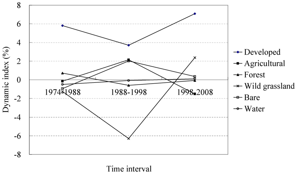
3.5. Dynamic Index of Land-Use/Land-Cover
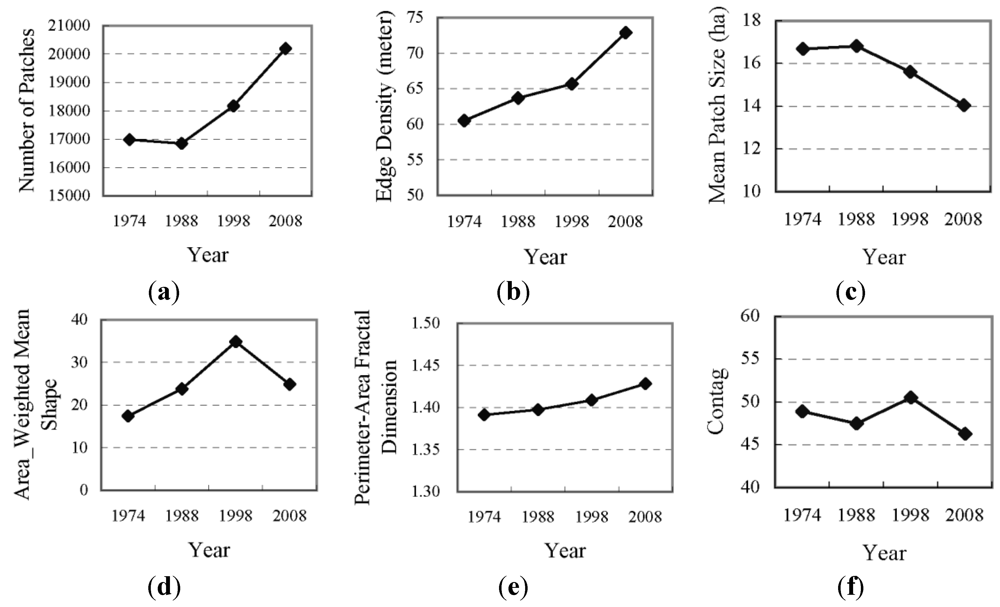
3.6 Landscape Metrics
| Metric | Description | Unit | Range |
|---|---|---|---|
| NP: Number of patches | NP equals the number of patches of the corresponding patch type (class). | None | NP ≥ 1, no limit |
| MPS: Mean Patch Size | MPS equals the sum, across all patches in the landscape, of the corresponding patch metric values divided by the total number of patches and 10,000 (to convert into hectares). | Hectares per patch | MPS ≥ 0, no limit |
| ED: Edge Density | ED equals the sum of the lengths (m) of all edge segments in the landscape divided by the total landscape area (m2) multiplied by 10,000 (to convert into hectares). | Meters per hectare | ED ≥ 0, no limit |
| AWMS: Area-Weighted Mean Shape | AWMS equals the sum, across all patches in the landscape, of the corresponding patch metric value multiplied by the proportional abundance of the patch [ i.e., the patch area (m2) divided by the sum of patch areas]. | None | AWMS ≥ 1 |
| PAFRAC: Perimeter Area Fractal Dimension | PAFRAC equals 2 divided by the slope of the regression line obtained by regressing the logarithm of the patch area (m2) against the logarithm of the patch perimeter (m). | None | 1 ≤ PAFRAC ≤ 2 |
| CONTAG: Contagion Index | CONTAG measures the overall probability that a cell of a patch type is adjacent to cells of the same type. | Percent | 0 < CONTAG ≤ 100 |
| AI: Aggregation Index | AI equals the number of like adjacencies involving the corresponding class divided by the maximum possible number of like adjacencies involving the corresponding class, which is achieved when the class is maximally clumped into a single, compact patch; multiplied by 100 (to convert into a percentage). | Percent | 0 < CONTAG ≤ 100 |
| LPI: Largest Patch Index | LPI equals the area (m2) of the largest patch of the corresponding patch type divided by the total landscape area (m2) multiplied by 100 (to convert into a percentage); i.e., LPI equals the percentage of the landscape comprised by the largest patch. | Percent | 0 < LPI ≤ 100 |
4. Results and Discussion
4.1. Land-Use/Land-Cover Maps and Accuracy Assessment
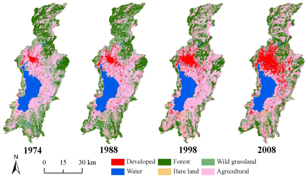
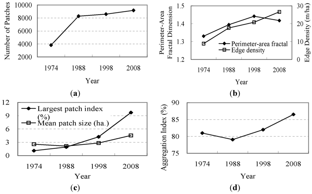
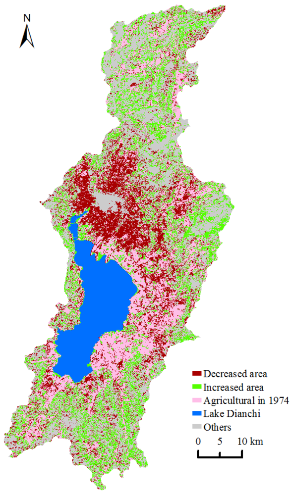
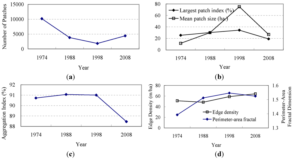
4.2. Structure, LULCC, and Landscape
| Land-Use/Land-Cover Type | 1974 | 1988 | 1998 | 2008 | Relative Change 1974–2008 (%) | ||||
|---|---|---|---|---|---|---|---|---|---|
| Area (km2) | % | Area (km2) | % | Area (km2) | % | Area (km2) | % | ||
| Developed area | 98.4 | 3.5 | 178.4 | 6.3 | 244.4 | 8.6 | 417.6 | 14.7 | 324.4 |
| Agricultural land | 1,175.8 | 41.5 | 1,151.7 | 40.6 | 1,399.4 | 49.4 | 1,187.6 | 41.9 | 1.0 |
| Forest land | 648.3 | 22.9 | 714.1 | 25.2 | 671.9 | 23.7 | 666.8 | 23.5 | 2.8 |
| Wild grassland | 533.5 | 18.8 | 440.7 | 15.5 | 163.4 | 5.8 | 202.1 | 7.1 | −62.1 |
| Bare land | 46.6 | 1.6 | 40.5 | 1.4 | 48.7 | 1.7 | 50.4 | 1.8 | 8.2 |
| Water | 332.2 | 11.7 | 309.4 | 10.9 | 307.1 | 10.8 | 310.2 | 10.9 | −6.6 |
| 1974/2008 | Developed Area | Agricultural Land | Forest Land | Wild Grassland | Water | Bare Land | Total |
|---|---|---|---|---|---|---|---|
| Developed area | 66.9 | 25.1 | 2.3 | 2.6 | 0.7 | 0.8 | 98.4 |
| Agricultural land | 291.4 | 673.0 | 119.5 | 66.2 | 3.2 | 22.5 | 1,175.8 |
| Forest land | 10.1 | 194.9 | 418.3 | 21.4 | 0.6 | 2.9 | 648.3 |
| Wild grassland | 38.5 | 249.8 | 119.4 | 103.1 | 3.0 | 19.8 | 533.5 |
| Water | 4.6 | 22.9 | 0.7 | 0.7 | 302.6 | 0.8 | 332.2 |
| Bare land | 6.1 | 22.0 | 6.7 | 8.1 | 0.1 | 3.7 | 46.6 |
| Total | 417.6 | 1,187.6 | 666.8 | 202.1 | 310.2 | 50.4 | 2,834.8 |
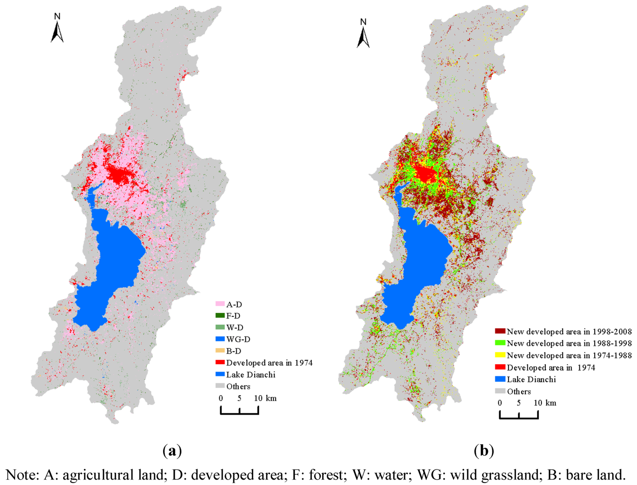
4.3. Developed Area Changes

4.4. Agricultural Land Changes


5. Conclusions
Acknowledgements
References
- Yong, J. China’s water scarcity. J. Environ. Manag. 2009, 90, 3185–3196. [Google Scholar] [CrossRef]
- Younger, P.L. Mine water pollution in Scotland: Nature, extent and preventative strategies. Sci. Total Environ. 2001, 265, 309–326. [Google Scholar]
- Sivertun, A.; Prange, L. Non-point source critical area analysis in the Gisselo watershed using GIS. Environ. Model. Software 2003, 18, 887–898. [Google Scholar] [CrossRef]
- Carpenter, S.R.; Fisher, S.G.; Grimm, N.B.; Kitchell, J.F. Global change and freshwater ecosystems. Annu. Rev. Ecol. Syst. 1992, 23, 119–139. [Google Scholar]
- Tang, Z.; Engel, B.A.; Pijanowski, B.C.; Lim, K.J. Forecasting land use change and its environmental impact at a watershed scale. J. Environ. Manage. 2005, 76, 35–45. [Google Scholar] [CrossRef]
- Ngoye, E.; Machiwa, J.F. The influence of land-use patterns in the Ruvu river watershed on water quality in the river system. Phys. Chem. Earth 2004, 29, 1161–1166. [Google Scholar]
- Mattikalli, N.M.; Richards, K.S. Estimation of surface water quality changes in response to land use change: Application of the export coefficient model using remote sensing and geographical information system. J. Environ. Manage. 1996, 48, 263–282. [Google Scholar] [CrossRef]
- Fisher, D.S.; Steiner, J.L.; Endale, D.M.; Stuedemann, J.A.; Schomberg, H.H.; Franzluebbers, A.J.; Wilkinson, S.R. The relationship of land use practices to surface water quality in the Upper Oconee Watershed of Georgia. Forest Ecol. Manage. 2000, 128, 39–48. [Google Scholar] [CrossRef]
- Wolter, P.T.; Johnston, C.A.; Niemi, G.J. Land use land cover change in the U.S. Great Lakes basin 1992 to 2001. J. Great Lakes Res. 2006, 32, 607–628. [Google Scholar] [CrossRef]
- Lautenbach, S.; Kugel, C.; Lausch, A.; Seppelt, R. Analysis of historic changes in regional ecosystem service provisioning using land use data. Ecol. Indic. 2011, 11, 676–687. [Google Scholar] [CrossRef]
- Viglizzo, E.F.; Frank, F.C. Land-use options for Del Plata basin in South America: Tradeoffs analysis based on ecosystem service provision. Ecol. Econ. 2006, 57, 140–151. [Google Scholar] [CrossRef]
- Jha, R.; Ojha, C.S.P.; Bhatia, K.K.S. Non-point source pollution estimation using a modified approach. Hydrol. Process. 2007, 21, 1098–1105. [Google Scholar] [CrossRef]
- Jat, M.K.; Khare, D.; Garg, P.K.; Shankar, V. Remote sensing and GIS-based assessment of urbanisation and degradation of watershed health. Urban. Water J. 2009, 6, 251–263. [Google Scholar]
- Wang, C.; Xie, Z.; Song, L.; Xiao, B.; Li, G.; Li, L. Dianchi Lake macroinvertebrate community succession trends and retrogressive analysis. Zool. Res. 2011, 32, 212–222. (in Chinese). [Google Scholar]
- Li, R.; Dong, M.; Zhao, Y.; Zhang, L.; Cui, Q.; He, W. Assessment of water quality and identification of pollution sources of plateau lakes in Yunnan (China). J. Environ. Qual. 2007, 36, 291–297. [Google Scholar] [CrossRef]
- Du, L.; Li, Y.; Chen, X.; Yang, J. Effect of eutrophication on molluscan community composition in the Lake Dianchi (China, Yunnan). Limnologica. Ecol. Manage. Inland Waters 2011, 41, 213–219. [Google Scholar] [CrossRef]
- Gray, A.V.; Li, W. Case study on water quality modelling of Dianchi lake, Yunnan province, South West China. Water Sci. Technol. 1999, 40, 35–43. [Google Scholar]
- Li, L.; Xie, S.G.; Zhang, H.; Wen, D.H. Field experiment on biological contact oxidation process to treat polluted river water in the Dianchi Lake watershed. Frontiers Environ. Sci. Eng. China 2009, 3, 38–47. [Google Scholar] [CrossRef]
- Ghadouani, A.; Coggins, L.X. Science, technology and policy for water pollution control at the watershed scale: Current issues and future challenges. Phys. Chem. Earth 2011, 36, 335–341. [Google Scholar] [CrossRef]
- Qu, J.H.; Fan, M.H. The current state of water quality and technology development for water pollution control in China. Cri. Rev. Environ. Sci. Technol. 2010, 40, 519–560. [Google Scholar] [CrossRef]
- Meng, W. System engineering for water pollution control at the watershed level in China. Frontiers Environ. Sci. Eng. China 2009, 3, 443–452. [Google Scholar] [CrossRef]
- Huang, D.; Bader, H.P.; Scheidegger, R.; Schertenleib, R.; Gujer, W. Confronting limitations: New solutions required for urban water management in Kunming City. J. Environ. Manage. 2007, 84, 49–61. [Google Scholar] [CrossRef]
- Gao, H.Y.; Liu, T.; Zhu, F.T.; Deng, L. Characteristics of organic phosphorus in sediments of Lake Dianchi, China. Fresenius Environ. Bull. 2010, 19, 3125–3130. [Google Scholar]
- Wang, K.; Liu, Y.D.; Li, D.H. Biosorption of copper by cyanobacterial bloom-derived biomass harvested from the eutrophic Lake Dianchi in China. Curr. Microbiol. 2010, 61, 340–345. [Google Scholar] [CrossRef]
- Li, L.H.; Xu, H.G.; Bao, A.M.; Pan, X.L.; Yuan, S.L.; Feng, X.W. Environmental Sustainability of Urban Lake Dianchi. In Proceedings of 2009 Conference on Systems Science, Management Science & System Dynamics, Shanghai, China, 29-31 May 2009; pp. 217–222.
- Zhang, H.; Li, H.; Chen, Z. Analysis of land use dynamic change and its impact on the water environment in Yunnan Plateau lake area: A case study of the Dianchi Lake drainage area. Procedia. Environ. Sci. 2011, 10, 2709–2717. [Google Scholar] [CrossRef]
- Tan, L.; Li, M.C.; Liu, Y.X.; Wei, W.; Hu, W. Study of Urban Expansion Simulation on the Condition of Ecological Environment Protection-A Case Study in Dianchi. Basin in Kunming. In Proceeding of 2009 Joint Urban Remote Sensing Event, Shanghai, China, 20-22 May 2009; pp. 505–510.
- Wu, F.; Qing, H.; Wan, G. Regeneration of N, P and Si near the sediment/water interface of lakes from Southwestern China Plateau. Water Res. 2001, 35, 1334–1337. [Google Scholar] [CrossRef]
- Zhang, R.; Wu, F.; Liu, C.; Fu, P.; Li, W.; Wang, L.; Liao, H.; Guo, J. Characteristics of organic phosphorus fractions in different trophic sediments of lakes from the middle and lower reaches of Yangtze River region and Southwestern Plateau, China. Environ. Pollut. 2008, 152, 366–372. [Google Scholar] [CrossRef]
- Gong, Z.; Li, Y.; Shen, J.; Xie, P. Diatom community succession in the recent history of a eutrophic Yunnan Plateau lake, Lake Dianchi, in subtropical China. Limnology 2009, 10, 247–253. [Google Scholar] [CrossRef]
- Pan, M.; Gao, L. The influence of socio-economic development on water quality in the Dianchi Lake. Eng. Sci. 2010, 12, 117–122. (in Chinese). [Google Scholar]
- Treitz, P.; Rogan, J. Remote sensing for mapping and monitoring land-cover and land-use change -An introduction. Prog. Plann. 2004, 61, 269–279. [Google Scholar] [CrossRef]
- Rogan, J.; Chen, D. Remote sensing technology for mapping and monitoring land-cover and land-use change. Prog. Plann. 2004, 61, 301–325. [Google Scholar] [CrossRef]
- Yuan, F.; Sawaya, K.E.; Loeffelholz, B.C.; Bauer, M.E. Land cover classification and change analysis of the twin cities (Minnesota) metropolitan area by multitemporal Landsat remote sensing. Remote Sens. Environ. 2005, 98, 317–328. [Google Scholar] [CrossRef]
- Prenzel, B.; Treitz, P. Remote sensing change detection for a watershed in North Sulawesi, Indonesia. Prog. Plann. 2004, 61, 349–363. [Google Scholar] [CrossRef]
- Xian, G.; Crane, M. Assessments of urban growth in the Tampa Bay watershed using remote sensing data. Remote Sens. Environ. 2005, 97, 203–215. [Google Scholar] [CrossRef]
- Li, R.; Zhao, L.; Haigh, T.; Tang, Z. Monitoring watershed drought conditions through the Landsat imagery interpretation. Disaster Adv. 2010, 3, 40–46. [Google Scholar]
- Huang, M.X.; Gong, J.H.; Shi, Z.; Liu, C.B.; Zhang, L.H. Genetic algorithm-based decision tree classifier for remote sensing mapping with SPOT-5 data in the HongShiMao watershed of the loess plateau, China. Neural Comput. Appl. 2007, 16, 513–517. [Google Scholar] [CrossRef]
- Saran, S.; Sterk, G.; Kumar, S. Optimal land use/land cover classification using remote sensing imagery for hydrological modeling in a Himalayan watershed. J. Appl. Remote Sens. 2009. [Google Scholar] [CrossRef]
- Andersen, J.R.; Hardy, E.E.; Roach, J.T.; Witmer, R.E. A Land-Use and Land-Cover Classification System for Use with Remote Sensor Data; Geological Survey Professional Paper 964; United States Government Printing Office: Washington, DC, USA, 1976; pp. 1–28. [Google Scholar]
- Sokal, R. Classification purposes principles progress prospects. Science 1974, 185, 1115–1123. [Google Scholar]
- Feng, C.C.; Flewelling, D.M. Assessment of semantic similarity between land use/land cover classification systems. Comput. Environ. Urban. Syst. 2004, 28, 229–246. [Google Scholar] [CrossRef]
- Jansen, L.J.M.; Gregorio, A.D. Parametric land-cover and land-use classifications as tools for environmental change detection. Agric. Ecos. Environ. 2002, 91, 89–100. [Google Scholar] [CrossRef]
- Maiti, S.; Bhattacharya, A.K. A three-unit-based approach in coastal-change studies using Landsat images. Int. J. Remote Sens. 2011, 32, 209–229. [Google Scholar] [CrossRef]
- Ellis, J.T.; Spruce, J.P.; Swann, R.A.; Smoot, J.C.; Hilbert, K.W. An assessment of coastal land-use and land-cover change from 1974-2008 in the vicinity of Mobile Bay, Alabama. J. Coast. Conserv. 2011, 15, 139–149. [Google Scholar] [CrossRef]
- Zhao, Y.; Murayama, Y. Effect of spatial scale on urban land-use pattern analysis in different classification systems: An empirical study in the CBD of Tokyo. Theory Appl. GIS 2006, 14, 29–42. [Google Scholar] [CrossRef]
- Wang, X.; Bao, Y. Study on the methods of land use dynamic change research. Prog. Geog. 1999, 18, 81–87. (in Chinese). [Google Scholar]
- Dunn, C.P.; Sharpe, D.M.; Guntensbergen, G.R.; Stearns, F.; Yang, Z. Methods for Analyzing Temporal Changes in Landscape Pattern. In Quantitative Methods in Landscape Ecology: The Analysis and Interpretation of Landscape Heterogeneity; Turner, M.G., Gardner, R.H., Eds.; Springer Verlag: New York, NY, USA, 1991; pp. 173–198. [Google Scholar]
- Wu, J.; Jelinski, E.J.; Luck, M.; Tueller, P.T. Multiscale analysis of landscape heterogeneity: Scale variance and pattern metrics. Geogr. Inf. Sci. 2000, 6, 6–19. [Google Scholar]
- Zhao, Y.; Murayama, Y. Urban dynamics analysis using spatial metrics: A case study of Yokohama city. Tsukuba Geoenviron. Sci. 2006, 2, 9–18. [Google Scholar]
- Jones, K.B.; Neale, A.C.; Nash, M.S.; van Remortel, R.D.; Wickham, J.D.; Riitters, K.H.; O’Neill, R.V. Predicting nutrient and sediment loadings to streams from landscape metrics: A multiple watershed study from the United States Mid-Atlantic region. Landsc. Ecol. 2001, 16, 301–312. [Google Scholar] [CrossRef]
- Lundquist, J.E.; Lindner, L.R.; Popp, J. Using landscape metrics to measure suitability of a forested watershed: A case study for old growth. Can. J. For. Res. 2001, 31, 1786–1792. [Google Scholar] [CrossRef]
- Liu, Y.B.; Nishiyama, S.; Kusaka, T. Examining landscape dynamics at a watershed scale using landsat TM imagery for detection of wintering hooded crane decline in Yashiro, Japan. Environ. Manage. 2003, 31, 365–376. [Google Scholar] [CrossRef]
- Lin, Y.P.; Hong, N.M.; Wu, P.J.; Wu, C.F.; Verburg, P.H. Impacts of land use change scenarios on hydrology and land use patterns in the Wu-Tu watershed in Northern Taiwan. Landscape Urban. Plan. 2007, 80, 111–126. [Google Scholar] [CrossRef]
- Yang, X.J.; Liu, Z. Quantifying landscape pattern and its change in an estuarine watershed using satellite imagery and landscape metrics. Int. J. Remote Sens. 2005, 26, 5297–5323. [Google Scholar] [CrossRef]
- Lin, Y.P.; Wu, P.J.; Hong, N.M. The effects of changing the resolution of land-use modeling on simulations of land-use patterns and hydrology for a watershed land-use planning assessment in Wu-Tu, Taiwan. Landscape Urban Plan. 2008, 87, 54–66. [Google Scholar] [CrossRef]
- Lin, Y.P.; Verburg, P.H.; Chang, C.R.; Chen, H.Y.; Chen, M.H. Developing and comparing optimal and empirical land-use models for the development of an urbanized watershed forest in Taiwan. Landscape Urban Plan. 2009, 92, 242–254. [Google Scholar] [CrossRef]
- Mandelbrot, B.B. Fractals-A geometry of nature. New Sci. 1990, 127, 38–43. [Google Scholar]
- McGarigal, K.; Cushman, S.A.; Neel, M.C.; Ene, E. Spatial Pattern Analysis Program for Categorical Maps. Available online: http://www.umass.edu/landeco/research/fragstats/fragstats.html (accessed on 2 June 2007).
- Zhou, Y.X.; Ma, L. China’s urbanization levels: Reconstructing comparable time-series data based on the fifth population census. China Q. 2003, 173, 184–204. [Google Scholar]
- Huang, Y.; Wen, H.; Cai, J.; Cai, M.; Sun, J. Key aquatic environmental factors affecting ecosystem health of streams in the Dianchi Lake watershed, China. Procedia. Environ. Sci. 2010, 2, 868–880. [Google Scholar] [CrossRef]
- Tan, M.; Li, X.; Xie, H.; Lu, C. Urban land expansion and arable land loss in China-A case study of Beijing-Tianjin-Hebei region. Land Use Policy 2005, 22, 187–196. [Google Scholar]
- Li, R.; Guan, Q.; Merchant, J. A geospatial modeling framework for assessing biofuels-related land-use and land-cover change. Agr. Ecosyst. Environ. 2012, 161, 17–26. [Google Scholar] [CrossRef]
- Wickham, J.D.; Rhtters, K.H. Sensitivity of landscape metrics to pixel size. Int. J. Remote Sens. 1995, 16, 3585–3594. [Google Scholar] [CrossRef]
- Wei, Y.; Zhao, M. Urban spill over vs. local urban sprawl: Entangling land-use regulations in the urban growth of China’s megacities. Land Use Policy 2009, 26, 1031–1045. [Google Scholar] [CrossRef]
- Ding, C. Land policy reform in China: Assessment and prospects. Land Use Policy 2003, 20, 109–120. [Google Scholar] [CrossRef]
- Ding, C. Policy and praxis of land acquisition in China. Land Use Policy 2007, 24, 1–13. [Google Scholar]
- Li, W.; Feng, T.; Hao, J. The evolving concepts of land administration in China: Cultivated land protection perspective. Land Use Policy 2009, 26, 262–272. [Google Scholar] [CrossRef]
- Skinner, M.W.; Kuhn, R.G.; Joseph, A.E. Agricultural land protection in China: A case study of local governance in Zhejiang Province. Land Use Policy 2001, 18, 329–340. [Google Scholar] [CrossRef]
© 2012 by the authors; licensee MDPI, Basel, Switzerland. This article is an open-access article distributed under the terms and conditions of the Creative Commons Attribution license (http://creativecommons.org/licenses/by/3.0/).
Share and Cite
Zhao, Y.; Zhang, K.; Fu, Y.; Zhang, H. Examining Land-Use/Land-Cover Change in the Lake Dianchi Watershed of the Yunnan-Guizhou Plateau of Southwest China with Remote Sensing and GIS Techniques: 1974–2008. Int. J. Environ. Res. Public Health 2012, 9, 3843-3865. https://doi.org/10.3390/ijerph9113843
Zhao Y, Zhang K, Fu Y, Zhang H. Examining Land-Use/Land-Cover Change in the Lake Dianchi Watershed of the Yunnan-Guizhou Plateau of Southwest China with Remote Sensing and GIS Techniques: 1974–2008. International Journal of Environmental Research and Public Health. 2012; 9(11):3843-3865. https://doi.org/10.3390/ijerph9113843
Chicago/Turabian StyleZhao, Yaolong, Ke Zhang, Yingchun Fu, and Hong Zhang. 2012. "Examining Land-Use/Land-Cover Change in the Lake Dianchi Watershed of the Yunnan-Guizhou Plateau of Southwest China with Remote Sensing and GIS Techniques: 1974–2008" International Journal of Environmental Research and Public Health 9, no. 11: 3843-3865. https://doi.org/10.3390/ijerph9113843